Embed Size (px)
Citation preview

Slide: 1 EUM/SES/VWG/07/0141 GSCB Workshop 2007, ESRIN
GSCB Workshop 2007: EUMETSAT Missions
Dr. Graeme Mason, EUMETSAT.GSCB Workshop 2007,
ESRIN, Frascati,19 June 2007.

Slide: 2 EUM/SES/VWG/07/0141 GSCB Workshop 2007, ESRIN
Introduction To EUMETSAT
• The European Organisation for the Exploitation of Meteorological Satellites, EUMETSAT, is an intergovernmental organisation, established in 1986 and is headquartered in Darmstadt, Germany.
• EUMETSAT is funded by the National Meteorological Services of its Member States to deliver cost efficient operational satellite data and products that satisfy the meteorological and climate data requirements of the Member States, taking into account the recommendations of the World Meteorological Organisation (WMO).
• EUMETSAT’s primary objective is “to establish, maintain and exploit European systems of operational meteorological satellites.”
• A further objective is “to contribute to the operational monitoring of the climate and the detection of global climatic changes.”

Slide: 3 EUM/SES/VWG/07/0141 GSCB Workshop 2007, ESRIN
EUMETSAT Missions
• EUMETSAT operates and processes and disseminates data from:
– first generation Meteosat geostationary satellites (Meteosat-6, 7),
– second generation Meteosat geostationary satellites (Meteosat-8, 9),
– polar-orbiting Metop satellites (Metop-A).
• EUMETSAT also routinely acquires, processes and disseminates data from:
– NOAA polar-orbiting satellites (NOAA-18).
• From mid-2008, EUMETSAT will also process and disseminate data from:
– Ocean Surface Topography Mission (Jason-2).
Slide: 4 EUM/SES/VWG/07/0141 GSCB Workshop 2007, ESRIN
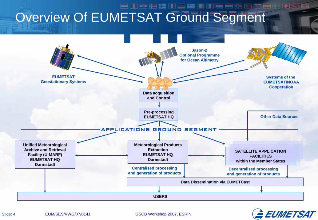
Overview Of EUMETSAT Ground Segment
Data acquisitionand Control
Pre-processingEUMETSAT HQ
Meteorological ProductsExtraction
EUMETSAT HQDarmstadt
Unified MeteorologicalArchive and Retrieval
Facility (U-MARF)EUMETSAT HQ
Darmstadt
SATELLITE APPLICATIONFACILITIES
within the Member States
Data Dissemination via EUMETCast
APPLICATIONS GROUND SEGMENT
EUMETSATGeostationary Systems
Systems of the EUMETSAT/NOAA
Cooperation
Other Data Sources
Centralised processingand generation of products
Decentralised processingand generation of products
USERS
Jason-2Optional Programmefor Ocean Altimetry

Slide: 5 EUM/SES/VWG/07/0141 GSCB Workshop 2007, ESRIN
Distributed Applications Ground Segment
4
7
6
2
15 8
3
Member State
Cooperating State
Support to Nowcasting and Very Short Range Forecasting
Ocean and Sea Ice
Climate Monitoring
Numerical Weather Prediction
Land Surface Analysis
Ozone and Atmospheric Chemistry Monitoring
GRAS Meteorology
Support to Operational Hydrology and Water Management
SAF Consortium Member
Additional Met Service Users
6
7
8
5
4
3
2
1

Slide: 6 EUM/SES/VWG/07/0141 GSCB Workshop 2007, ESRIN
Interoperability Between EUMETSAT Missions
• EUMETSAT is directly funded by its user community, and thereforeconsiders the most important aspects regarding interoperability between its missions to be related to the delivery of data and products to the users.
• On-line “Product Navigator” available providing essential information about more than 200 data products available through EUMETSAT and a guide to users as to how to access these products:
www.eumetsat.int/products
• Single archive (Unified Archive and Retrieval Facility, U-MARF):http://archive.eumetsat.org/umarf
• Common dissemination system for all near real-time products (satellite based digital video broadcast (DVB) system called EUMETCast).
• (Other dissemination mechanisms include WMO Global Telecommunications System (GTS) and Regional Meteorological DataCommunications Network (RMDCN) and FTP).

Slide: 7 EUM/SES/VWG/07/0141 GSCB Workshop 2007, ESRIN
EUMETSAT Product Navigator

Slide: 8 EUM/SES/VWG/07/0141 GSCB Workshop 2007, ESRIN
Unified EUMETSAT Archive
U-MARF
EUMETSAT administration
MSG Ground Segment
MTP Ground Segment
SAFs
EPS Ground Segment
EUMETSAT internal Users
End users
Internet
Production
DHL
• Archive for all EUM centrally generated products, plus some SAF products.
• Central catalogue (also for distributed SAF products).
• Over 1300 registered users.
• On-line product ordering.
• Ingestion: 186 GB per day (EPS), 108 GB per day (MSG-1/2).
• Retrieval: 2 TB per day, 180,000 retrieval jobs executed in 2006.

Slide: 9 EUM/SES/VWG/07/0141 GSCB Workshop 2007, ESRIN
Unified EUMETSAT Archive: On-line Ordering

Slide: 10 EUM/SES/VWG/07/0141 GSCB Workshop 2007, ESRIN
Interoperability With Other Archives
• Local archiving and cataloguing at distributed Satellite Application Facilities (SAFs) for the SAF products (except Ocean and Sea Ice SAF).
• EUMETSAT provided SAF client software transfers metadata and browse files from SAF archives to U-MARF, allowing users to order all SAF products from central U-MARF.
• Heterogeneous Mission Accessibility (HMA) prototyping for U-MARF currently ongoing in EUMETSAT – expected to be completed in July (excluding user management and mission planning specifications).
• Future plans to upgrade the U-MARF in accordance with OGC, WMO and ISO standards to be compatible with:– HMA, and GEO,– WMO Information System (WIS) and the Virtual Global Information
System Centres (V-GISC) initiative.Timescale for implementation: 2008 – 2009.

Slide: 11 EUM/SES/VWG/07/0141 GSCB Workshop 2007, ESRIN
Long-Term Data Preservation
• Legacy data from all Meteosat satellites back to Meteosat-2 launch in 1981 migrated into U-MARF.
• New EUMETSAT programmes fund the transcription of previous programme archives so that they ‘inherit’ the existing archive, thus ensuring long-term data preservation.
• Data and products from on-going missions archived routinely.
• Multiple copies of all archived data maintained – second copy stored off-site (Offenbach), with third copy on disk for most demanded products.
• Periodic migration of data onto new media (from experience, approximately every 5 years).
• U-MARF catalogue data and products versioning ensures support to reprocessing.

Slide: 12 EUM/SES/VWG/07/0141 GSCB Workshop 2007, ESRIN
EUMETCast Dissemination System
• EUMETCast is EUMETSAT’s common dissemination system (based on standard DVB technology) for all near real-time products.
• EUMETCast used for dissemination of:– EUMETSAT Meteosat and Metop Data;– Near real-time products from EUMETSAT SAFs;– Foreign Satellite Data (NOAA, GOES, MTSAT);– Meteorological Products and Forecast Data (ECMWF, DWD, MetOffice);– Deutscher Wetterdienst (DWDSAT);– Data Collection Platforms;– Meteorological Data Dissemination (for WMO Region I including PUMA/AMESD);– Basic Meteorological Data (for WMO Region VI);– EARS (EUMETSAT Advanced Re-transmission System) Data;– VEGETATION products from VITO.
• More than 2200 registered EUMETCast reception terminals.

Slide: 13 EUM/SES/VWG/07/0141 GSCB Workshop 2007, ESRIN
EUMETCast Dissemination System
EUMETSATData
SAF Data
DWDSAT
VITO Data
GTS/RMDCNData
Uplink Providerat Usingen
TurnaroundProvider 1
Users TurnaroundProvider 2
Users
Users
Communication LinesSatellite 1
Satellite 3
Satellite 2
Slide: 14 EUM/SES/VWG/07/0141 GSCB Workshop 2007, ESRIN
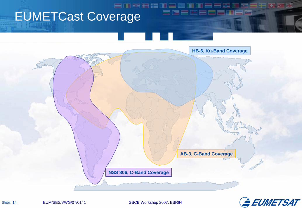
EUMETCast Coverage
HB-6, Ku-Band Coverage
AB-3, C-Band Coverage
NSS 806, C-Band Coverage

Slide: 15 EUM/SES/VWG/07/0141 GSCB Workshop 2007, ESRIN
GEONETCast
• GEONETCast is a contributing element to the emerging Global Earth Observation System of Systems (GEOSS) that is being coordinated by the intergovernmental Group on Earth Observations (GEO).
• GEONETCast is a global network of satellite based data dissemination systems providing environmental data to a world-wide user community.
• GEONETCast consists of:EUMETCast: EUMETSAT’s contribution.FengYunCast: The China Meteorological
Administration’s contribution, utilising the AsiaSat4 satellite to broadcast data and products to a usercommunity in the Asia-Pacific region.
GEONETCast-Americas: A future broadcast system covering the Americas, which is currently being planned by NOAA.
Slide: 16 EUM/SES/VWG/07/0141 GSCB Workshop 2007, ESRIN
EUMETSAT Data Policy
• EUMETSAT is the owner of its satellites plus the data and products generated from the satellites and the EUMETSAT ground segment.
• National Meteorological Services (NMSs) of EUMETSAT Member States receive all EUMETSAT data for Official Duty use at no cost.
• NMSs of EUMETSAT Member States act as Exclusive Licensing Agents of EUMETSAT for users within their national territories, and apply the uniform EUMETSAT fees and conditions.
• EUMETSAT Secretariat acts as licensing authority for users outside of EUMETSAT Member States and for international organisations.
• EUMETSAT Secretariat is also licensing authority for archived data and for derived products generated by the EUMETSAT ground segment.

Slide: 17 EUM/SES/VWG/07/0141 GSCB Workshop 2007, ESRIN
EUMETSAT Data Policy
• A set of data is declared as “Essential”, as defined by WMO, and provided free of charge to all users, world-wide (e.g. 6-hourly image data, all data from Metop local mission).
• A further set of data is provided to NMSs of non-Member States free of charge for Official Duty use (e.g. 3-hourly image data).
• Free of charge access to all data is given for scientific and educational use (including “amateur” use).
• Other types of users have to pay a fee, which varies depending on user category (i.e. End Users, Service Providers or Broadcasters).
• Commercial activities of NMSs of Member States are treated like Service Providers.

Slide: 18 EUM/SES/VWG/07/0141 GSCB Workshop 2007, ESRIN
A GMES Perspective
• Data and products from the EUMETSAT satellites (Meteosat, Metop), together with EUMETSAT generated products from other satellites (e.g. NOAA, Jason) are expected to be highly relevant to GMES.
• In particular for the Atmospheric and Marine services, for which these satellites are expected to provide a significant portion of the necessary data.
• Also for the Land service with respect to global land products.
• EUMETSAT is encouraging the use of these data and products for GMES services and applications providing the existing EUMETSAT Data Policy is respected and the “identity” of EUMETSAT is preserved.