Embed Size (px)
Citation preview
APPENDIX E

Certified Sanborn® Map Report
Inquiry Number:
6 Armstrong Road, 4th floor Shelton, CT 06484Toll Free: 800.352.0050 www.edrnet.com
1402 W. Pico Avenue
1402 W. Pico Avenue
El Centro, CA 92243
December 15, 2016
4807201.3

Certified Sanborn® Map Report
Certified Sanborn Results:
Disclaimer - Copyright and Trademark Notice
EDR and its logos (including Sanborn and Sanborn Map) are trademarks of Environmental Data Resources, Inc. or its affiliates. All other trademarks used herein are the property of their respective owners.
page-
The Sanborn Library includes more than 1.2 millionfire insurance maps from Sanborn, Bromley, Perris &Browne, Hopkins, Barlow and others which trackhistorical property usage in approximately 12,000American cities and towns. Collections searched:
Library of Congress
University Publications of America
EDR Private Collection
The Sanborn Library LLC Since 1866™
Limited Permission To Make Copies
Sanborn® Library search results
Certification #
Contact:EDR Inquiry #
Site Name: Client Name:
PO #
Project
12/15/16
1402 W. Pico Avenue GS Lyon Consultants1402 W. Pico Avenue 780 N. Fourth StreetEl Centro, CA 92243 El Centro, CA 92243
4807201.3 Steven Williams
The Sanborn Library has been searched by EDR and maps covering the target property location as provided by GS Lyon Consultants wereidentified for the years listed below. The Sanborn Library is the largest, most complete collection of fire insurance maps. The collectionincludes maps from Sanborn, Bromley, Perris & Browne, Hopkins, Barlow, and others. Only Environmental Data Resources Inc. (EDR) isauthorized to grant rights for commercial reproduction of maps by the Sanborn Library LLC, the copyright holder for the collection. Resultscan be authenticated by visiting www.edrnet.com/sanborn.
The Sanborn Library is continually enhanced with newly identified map archives. This report accesses all maps in the collection as of theday this report was generated.
2567-4B5F-9828
NA
GS1635
UNMAPPED PROPERTY
This report certifies that the complete holdings of the Sanborn Library,LLC collection have been searched based on client supplied targetproperty information, and fire insurance maps covering the target propertywere not found.
Certification #: 2567-4B5F-9828
GS Lyon Consultants (the client) is permitted to make up to FIVE photocopies of this Sanborn Map transmittal and each fire insurance map accompanying this reportsolely for the limited use of its customer. No one other than the client is authorized to make copies. Upon request made directly to an EDR Account Executive, theclient may be permitted to make a limited number of additional photocopies. This permission is conditioned upon compliance by the client, its customer and theiragents with EDR's copyright policy; a copy of which is available upon request.
This Report contains certain information obtained from a variety of public and other sources reasonably available to Environmental Data Resources, Inc. It cannotbe concluded from this Report that coverage information for the target and surrounding properties does not exist from other sources. NO WARRANTYEXPRESSED OR IMPLIED, IS MADE WHATSOEVER IN CONNECTION WITH THIS REPORT. ENVIRONMENTAL DATA RESOURCES, INC. SPECIFICALLYDISCLAIMS THE MAKING OF ANY SUCH WARRANTIES, INCLUDING WITHOUT LIMITATION, MERCHANTABILITY OR FITNESS FOR A PARTICULAR USEOR PURPOSE. ALL RISK IS ASSUMED BY THE USER. IN NO EVENT SHALL ENVIRONMENTAL DATA RESOURCES, INC. BE LIABLE TO ANYONE,WHETHER ARISING OUT OF ERRORS OR OMISSIONS, NEGLIGENCE, ACCIDENT OR ANY OTHER CAUSE, FOR ANY LOSS OF DAMAGE, INCLUDING,WITHOUT LIMITATION, SPECIAL, INCIDENTAL, CONSEQUENTIAL, OR EXEMPLARY DAMAGES. ANY LIABILITY ON THE PART OF ENVIRONMENTALDATA RESOURCES, INC. IS STRICTLY LIMITED TO A REFUND OF THE AMOUNT PAID FOR THIS REPORT. Purchaser accepts this Report "AS IS". Anyanalyses, estimates, ratings, environmental risk levels or risk codes provided in this Report are provided for illustrative purposes only, and are not intended toprovide, nor should they be interpreted as providing any facts regarding, or prediction or forecast of, any environmental risk for any property. Only a Phase IEnvironmental Site Assessment performed by an environmental professional can provide information regarding the environmental risk for any property.Additionally, the information provided in this Report is not to be construed as legal advice.
Copyright 2016 by Environmental Data Resources, Inc. All rights reserved. Reproduction in any media or format, in whole or in part, of any report or map ofEnvironmental Data Resources, Inc., or its affiliates, is prohibited without prior written permission.
4807201 3 2

APPENDIX F

FORM-LBD-RG
®kcehCoeG htiw tropeR ™paM suidaR RDE ehT
6 Armstrong Road, 4th floorShelton, CT 06484Toll Free: 800.352.0050www.edrnet.com
1402 W. Pico Avenue1402 W. Pico AvenueEl Centro, CA 92243
Inquiry Number: 4807201.2sDecember 15, 2016

SECTION PAGE
Executive Summary ES1
Overview Map 2
Detail Map 3
Map Findings Summary 4
Map Findings 8
Orphan Summary 69
Government Records Searched/Data Currency Tracking GR-1
GEOCHECK ADDENDUM
Physical Setting Source Addendum A-1
Physical Setting Source Summary A-2
Physical Setting SSURGO Soil Map A-5
Physical Setting Source Map A-10
Physical Setting Source Map Findings A-12
Physical Setting Source Records Searched PSGR-1
TC4807201.2s Page 1
Thank you for your business.Please contact EDR at 1-800-352-0050
with any questions or comments.
Disclaimer - Copyright and Trademark Notice
This Report contains certain information obtained from a variety of public and other sources reasonably available to Environmental DataResources, Inc. It cannot be concluded from this Report that coverage information for the target and surrounding properties does not exist fromother sources. NO WARRANTY EXPRESSED OR IMPLIED, IS MADE WHATSOEVER IN CONNECTION WITH THIS REPORT. ENVIRONMENTALDATA RESOURCES, INC. SPECIFICALLY DISCLAIMS THE MAKING OF ANY SUCH WARRANTIES, INCLUDING WITHOUT LIMITATION,MERCHANTABILITY OR FITNESS FOR A PARTICULAR USE OR PURPOSE. ALL RISK IS ASSUMED BY THE USER. IN NO EVENT SHALLENVIRONMENTAL DATA RESOURCES, INC. BE LIABLE TO ANYONE, WHETHER ARISING OUT OF ERRORS OR OMISSIONS, NEGLIGENCE,ACCIDENT OR ANY OTHER CAUSE, FOR ANY LOSS OF DAMAGE, INCLUDING, WITHOUT LIMITATION, SPECIAL, INCIDENTAL,CONSEQUENTIAL, OR EXEMPLARY DAMAGES. ANY LIABILITY ON THE PART OF ENVIRONMENTAL DATA RESOURCES, INC. IS STRICTLYLIMITED TO A REFUND OF THE AMOUNT PAID FOR THIS REPORT. Purchaser accepts this Report "AS IS". Any analyses, estimates, ratings,environmental risk levels or risk codes provided in this Report are provided for illustrative purposes only, and are not intended to provide, norshould they be interpreted as providing any facts regarding, or prediction or forecast of, any environmental risk for any property. Only a Phase IEnvironmental Site Assessment performed by an environmental professional can provide information regarding the environmental risk for anyproperty. Additionally, the information provided in this Report is not to be construed as legal advice.
Copyright 2016 by Environmental Data Resources, Inc. All rights reserved. Reproduction in any media or format, in wholeor in part, of any report or map of Environmental Data Resources, Inc., or its affiliates, is prohibited without prior written permission.
EDR and its logos (including Sanborn and Sanborn Map) are trademarks of Environmental Data Resources, Inc. or its affiliates. All othertrademarks used herein are the property of their respective owners.
TABLE OF CONTENTS

EXECUTIVE SUMMARY
TC4807201.2s EXECUTIVE SUMMARY 1
A search of available environmental records was conducted by Environmental Data Resources, Inc (EDR).The report was designed to assist parties seeking to meet the search requirements of EPA’s Standardsand Practices for All Appropriate Inquiries (40 CFR Part 312), the ASTM Standard Practice forEnvironmental Site Assessments (E 1527-13) or custom requirements developed for the evaluation ofenvironmental risk associated with a parcel of real estate.
TARGET PROPERTY INFORMATION
ADDRESS
1402 W. PICO AVENUEEL CENTRO, CA 92243
COORDINATES
32.8066080 - 32˚ 48’ 23.78’’Latitude (North): 115.5680970 - 115˚ 34’ 5.14’’Longitude (West): Zone 11Universal Tranverse Mercator: 634062.2UTM X (Meters): 3630565.0UTM Y (Meters): 44 ft. below sea levelElevation:
USGS TOPOGRAPHIC MAP ASSOCIATED WITH TARGET PROPERTY
5622954 EL CENTRO, CATarget Property Map:2012Version Date:
AERIAL PHOTOGRAPHY IN THIS REPORT
20140606Portions of Photo from:USDASource:

4807201.2s Page 2
33 J.R. SIMPLOT DOGWOOD AND CHICK RO ENVIROSTOR Higher 5169, 0.979, SSE
I32 SO CAL GAS/EL CENTRO 970 NORTH 4TH STREET ENVIROSTOR, VCP, DEED, HIST CORTESE Lower 4734, 0.897, ESE
I31 SO CAL GAS/EL CENTRO 970 NORTH 4TH STREET EDR MGP Lower 4734, 0.897, ESE
30 MCDONALDS RESTAURANT 345 N. IMPERIAL AVE. LUST, HIST CORTESE, Notify 65 Higher 3621, 0.686, South
H29 R & M PETROLEUM 805 N IMPERIAL AVE LUST, CUPA Listings Higher 2236, 0.423, South
H28 EL CENTRO TEXACO 805 NORTH IMPERIAL A HWP Higher 2236, 0.423, South
27 PRIVATE RESIDENCE PRIVATE RESIDENCE LUST Higher 1748, 0.331, SSW
G26 EL CENTRO MAIN SEWER 1675 PICO HIST CORTESE Higher 1499, 0.284, WSW
G25 EL CENTRO MAIN SEWER 1675 WEST PICO AVENU LUST Higher 1499, 0.284, WSW
24 KMART #3151 1950 N IMPERIAL AVE CUPA Listings Lower 1073, 0.203, NNW
F23 HARBOR FREIGHT TOOL 1750 N IMPERIAL AVE CUPA Listings Lower 1059, 0.201, NW
F22 HARBOR FREIGHT TOOLS 1750 N IMPERIAL AVE RCRA-SQG, FINDS, ECHO Lower 1059, 0.201, NW
E21 US BORDER PATROL SEC 1111 N IMPERIAL AVE UST Higher 1005, 0.190, SSW
E20 US BORDER PATROL-EL 1111 N. IMPERIAL AVE AST Higher 1005, 0.190, SSW
E19 U.S.BORDER PATROL HE 1111 N IMPERIAL AVE LUST, SWEEPS UST, HIST UST, CA FID UST, CUPA... Higher 1005, 0.190, SSW
E18 USDOJ INS BORDER PAT 1111 N IMPERIAL AVE RCRA-SQG, FINDS, ECHO Higher 1005, 0.190, SSW
E17 IMMIGRATION & CUSTOM 1115 N. IMPERIAL AVE AST Higher 1000, 0.189, SSW
E16 U.S.IMMIGRATION & NA 1115 N IMPERIAL AVE SWEEPS UST, CA FID UST, CUPA Listings, HAZNET Higher 1000, 0.189, SSW
E15 IMMIGRATION AND CUST 1115 N. IMPERIAL AVE AST Higher 1000, 0.189, SSW
14 MAIN LIFT STATION 1625 W PICO ROAD HIST UST, CA FID UST Higher 933, 0.177, WSW
C13 U HAUL OF EL CENTRO 1746 S HIGHWAY 86 CA FID UST Lower 665, 0.126, NW
C12 U HAUL OF EL CENTRO 1746 SO HWY 86 HIST UST Lower 665, 0.126, NW
D11 COYNE (VACANT LOT) 1334 IMPERIAL LUST, HIST CORTESE Higher 638, 0.121, WSW
D10 IMPERIAL VALLEY CYCL 1334 N IMPERIAL AVE CUPA Listings Higher 638, 0.121, WSW
D9 IMPERIAL VALLEY CYCL 1334 N IMPERIAL AVE SWEEPS UST, CA FID UST Higher 638, 0.121, WSW
D8 SMART & FINAL #461 1290 N IMPERIAL AVE CUPA Listings Higher 587, 0.111, SW
C7 CARDENAS MARKETS, IN 1620 N IMPERIAL AVE CUPA Listings Higher 487, 0.092, NW
B6 SOUTHLAND CORP. #264 1360 N IMPERIAL AVE SWEEPS UST, CA FID UST Higher 462, 0.087, WSW
B5 7 ELEVEN STORE NO .2 1360 NORTH IMPERIAL LUST Higher 462, 0.087, WSW
B4 7 ELEVEN STORE NO .2 1360 NORTH IMPERIAL LUST, HIST CORTESE Higher 462, 0.087, WSW
A3 BRAWLEY ENDOSCOPY DB 1550 N IMPERIAL AVE CUPA Listings, HAZNET Higher 415, 0.079, West
B2 WESTERN DENTAL CENTE 1450 N IMPERIAL AVE CUPA Listings, HAZNET Higher 410, 0.078, WSW
A1 IMPERIAL VALLEY PODI 1503 N IMPERIAL AVE CUPA Listings, HAZNET Higher 196, 0.037, WNW
MAPPED SITES SUMMARY
Target Property Address:1402 W. PICO AVENUEEL CENTRO, CA 92243
Click on Map ID to see full detail.
MAP RELATIVE DIST (ft. & mi.)ID DATABASE ACRONYMS ELEVATION DIRECTIONSITE NAME ADDRESS

EXECUTIVE SUMMARY
TC4807201.2s EXECUTIVE SUMMARY 3
TARGET PROPERTY SEARCH RESULTS
The target property was not listed in any of the databases searched by EDR.
DATABASES WITH NO MAPPED SITES
No mapped sites were found in EDR’s search of available ("reasonably ascertainable ") governmentrecords either on the target property or within the search radius around the target property for thefollowing databases:
STANDARD ENVIRONMENTAL RECORDS
Federal NPL site list
NPL National Priority ListProposed NPL Proposed National Priority List SitesNPL LIENS Federal Superfund Liens
Federal Delisted NPL site list
Delisted NPL National Priority List Deletions
Federal CERCLIS list
FEDERAL FACILITY Federal Facility Site Information listingSEMS Superfund Enterprise Management System
Federal CERCLIS NFRAP site list
SEMS-ARCHIVE Superfund Enterprise Management System Archive
Federal RCRA CORRACTS facilities list
CORRACTS Corrective Action Report
Federal RCRA non-CORRACTS TSD facilities list
RCRA-TSDF RCRA - Treatment, Storage and Disposal
Federal RCRA generators list
RCRA-LQG RCRA - Large Quantity GeneratorsRCRA-CESQG RCRA - Conditionally Exempt Small Quantity Generator
Federal institutional controls / engineering controls registries
LUCIS Land Use Control Information SystemUS ENG CONTROLS Engineering Controls Sites ListUS INST CONTROL Sites with Institutional Controls
EXECUTIVE SUMMARY
TC4807201.2s EXECUTIVE SUMMARY 4
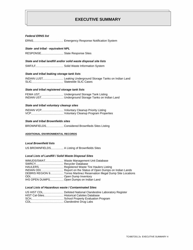
Federal ERNS list
ERNS Emergency Response Notification System
State- and tribal - equivalent NPL
RESPONSE State Response Sites
State and tribal landfill and/or solid waste disposal site lists
SWF/LF Solid Waste Information System
State and tribal leaking storage tank lists
INDIAN LUST Leaking Underground Storage Tanks on Indian LandSLIC Statewide SLIC Cases
State and tribal registered storage tank lists
FEMA UST Underground Storage Tank ListingINDIAN UST Underground Storage Tanks on Indian Land
State and tribal voluntary cleanup sites
INDIAN VCP Voluntary Cleanup Priority ListingVCP Voluntary Cleanup Program Properties
State and tribal Brownfields sites
BROWNFIELDS Considered Brownfieds Sites Listing
ADDITIONAL ENVIRONMENTAL RECORDS
Local Brownfield lists
US BROWNFIELDS A Listing of Brownfields Sites
Local Lists of Landfill / Solid Waste Disposal Sites
WMUDS/SWAT Waste Management Unit DatabaseSWRCY Recycler DatabaseHAULERS Registered Waste Tire Haulers ListingINDIAN ODI Report on the Status of Open Dumps on Indian LandsDEBRIS REGION 9 Torres Martinez Reservation Illegal Dump Site LocationsODI Open Dump InventoryIHS OPEN DUMPS Open Dumps on Indian Land
Local Lists of Hazardous waste / Contaminated Sites
US HIST CDL Delisted National Clandestine Laboratory RegisterHIST Cal-Sites Historical Calsites DatabaseSCH School Property Evaluation ProgramCDL Clandestine Drug Labs

EXECUTIVE SUMMARY
TC4807201.2s EXECUTIVE SUMMARY 5
Toxic Pits Toxic Pits Cleanup Act SitesUS CDL National Clandestine Laboratory Register
Local Land Records
LIENS Environmental Liens ListingLIENS 2 CERCLA Lien InformationDEED Deed Restriction Listing
Records of Emergency Release Reports
HMIRS Hazardous Materials Information Reporting SystemCHMIRS California Hazardous Material Incident Report SystemLDS Land Disposal Sites ListingMCS Military Cleanup Sites ListingSPILLS 90 SPILLS 90 data from FirstSearch
Other Ascertainable Records
RCRA NonGen / NLR RCRA - Non Generators / No Longer RegulatedFUDS Formerly Used Defense SitesDOD Department of Defense SitesSCRD DRYCLEANERS State Coalition for Remediation of Drycleaners ListingUS FIN ASSUR Financial Assurance InformationEPA WATCH LIST EPA WATCH LIST2020 COR ACTION 2020 Corrective Action Program ListTSCA Toxic Substances Control ActTRIS Toxic Chemical Release Inventory SystemSSTS Section 7 Tracking SystemsROD Records Of DecisionRMP Risk Management PlansRAATS RCRA Administrative Action Tracking SystemPRP Potentially Responsible PartiesPADS PCB Activity Database SystemICIS Integrated Compliance Information SystemFTTS FIFRA/ TSCA Tracking System - FIFRA (Federal Insecticide, Fungicide, & Rodenticide Act)/TSCA (Toxic Substances Control Act)MLTS Material Licensing Tracking SystemCOAL ASH DOE Steam-Electric Plant Operation DataCOAL ASH EPA Coal Combustion Residues Surface Impoundments ListPCB TRANSFORMER PCB Transformer Registration DatabaseRADINFO Radiation Information DatabaseHIST FTTS FIFRA/TSCA Tracking System Administrative Case ListingDOT OPS Incident and Accident DataCONSENT Superfund (CERCLA) Consent DecreesINDIAN RESERV Indian ReservationsFUSRAP Formerly Utilized Sites Remedial Action ProgramUMTRA Uranium Mill Tailings SitesLEAD SMELTERS Lead Smelter SitesUS AIRS Aerometric Information Retrieval System Facility SubsystemUS MINES Mines Master Index FileFINDS Facility Index System/Facility Registry SystemDOCKET HWC Hazardous Waste Compliance Docket ListingUXO Unexploded Ordnance SitesCA BOND EXP. PLAN Bond Expenditure Plan

EXECUTIVE SUMMARY
TC4807201.2s EXECUTIVE SUMMARY 6
Cortese "Cortese" Hazardous Waste & Substances Sites ListDRYCLEANERS Cleaner FacilitiesEMI Emissions Inventory DataENF Enforcement Action ListingFinancial Assurance Financial Assurance Information ListingHAZNET Facility and Manifest DataHWT Registered Hazardous Waste Transporter DatabaseMINES Mines Site Location ListingMWMP Medical Waste Management Program ListingNPDES NPDES Permits ListingPEST LIC Pesticide Regulation Licenses ListingPROC Certified Processors DatabaseUIC UIC ListingWASTEWATER PITS Oil Wastewater Pits ListingWDS Waste Discharge SystemWIP Well Investigation Program Case ListFUELS PROGRAM EPA Fuels Program Registered ListingABANDONED MINES Abandoned MinesICE ICEECHO Enforcement & Compliance History Information
EDR HIGH RISK HISTORICAL RECORDS
EDR Exclusive Records
EDR Hist Auto EDR Exclusive Historic Gas StationsEDR Hist Cleaner EDR Exclusive Historic Dry Cleaners
EDR RECOVERED GOVERNMENT ARCHIVES
Exclusive Recovered Govt. Archives
RGA LF Recovered Government Archive Solid Waste Facilities ListRGA LUST Recovered Government Archive Leaking Underground Storage Tank
SURROUNDING SITES: SEARCH RESULTS
Surrounding sites were identified in the following databases.
Elevations have been determined from the USGS Digital Elevation Model and should be evaluated ona relative (not an absolute) basis. Relative elevation information between sites of close proximityshould be field verified. Sites with an elevation equal to or higher than the target property have beendifferentiated below from sites with an elevation lower than the target property.Page numbers and map identification numbers refer to the EDR Radius Map report where detaileddata on individual sites can be reviewed.
Sites listed in bold italics are in multiple databases.
Unmappable (orphan) sites are not considered in the foregoing analysis.
EXECUTIVE SUMMARY
TC4807201.2s EXECUTIVE SUMMARY 7
STANDARD ENVIRONMENTAL RECORDS
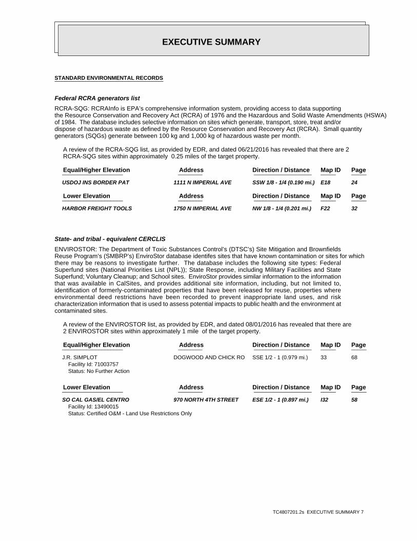
Federal RCRA generators list
RCRA-SQG: RCRAInfo is EPA’s comprehensive information system, providing access to data supportingthe Resource Conservation and Recovery Act (RCRA) of 1976 and the Hazardous and Solid Waste Amendments (HSWA)of 1984. The database includes selective information on sites which generate, transport, store, treat and/ordispose of hazardous waste as defined by the Resource Conservation and Recovery Act (RCRA). Small quantitygenerators (SQGs) generate between 100 kg and 1,000 kg of hazardous waste per month.
A review of the RCRA-SQG list, as provided by EDR, and dated 06/21/2016 has revealed that there are 2 RCRA-SQG sites within approximately 0.25 miles of the target property.
PageMap IDDirection / Distance Address Equal/Higher Elevation ____________________ ________ ___________________ _____ _____
USDOJ INS BORDER PAT 1111 N IMPERIAL AVE SSW 1/8 - 1/4 (0.190 mi.) E18 24
PageMap IDDirection / Distance Address Lower Elevation ____________________ ________ ___________________ _____ _____
HARBOR FREIGHT TOOLS 1750 N IMPERIAL AVE NW 1/8 - 1/4 (0.201 mi.) F22 32
State- and tribal - equivalent CERCLIS
ENVIROSTOR: The Department of Toxic Substances Control’s (DTSC’s) Site Mitigation and BrownfieldsReuse Program’s (SMBRP’s) EnviroStor database identifes sites that have known contamination or sites for whichthere may be reasons to investigate further. The database includes the following site types: FederalSuperfund sites (National Priorities List (NPL)); State Response, including Military Facilities and StateSuperfund; Voluntary Cleanup; and School sites. EnviroStor provides similar information to the informationthat was available in CalSites, and provides additional site information, including, but not limited to,identification of formerly-contaminated properties that have been released for reuse, properties whereenvironmental deed restrictions have been recorded to prevent inappropriate land uses, and riskcharacterization information that is used to assess potential impacts to public health and the environment atcontaminated sites.
A review of the ENVIROSTOR list, as provided by EDR, and dated 08/01/2016 has revealed that there are 2 ENVIROSTOR sites within approximately 1 mile of the target property.
PageMap IDDirection / Distance Address Equal/Higher Elevation ____________________ ________ ___________________ _____ _____
J.R. SIMPLOT DOGWOOD AND CHICK RO SSE 1/2 - 1 (0.979 mi.) 33 68Facility Id: 71003757Status: No Further Action
PageMap IDDirection / Distance Address Lower Elevation ____________________ ________ ___________________ _____ _____
SO CAL GAS/EL CENTRO 970 NORTH 4TH STREET ESE 1/2 - 1 (0.897 mi.) I32 58Facility Id: 13490015Status: Certified O&M - Land Use Restrictions Only

EXECUTIVE SUMMARY
TC4807201.2s EXECUTIVE SUMMARY 8
State and tribal leaking storage tank lists
LUST: Leaking Underground Storage Tank (LUST) Sites included in GeoTracker. GeoTracker is theWater Boards data management system for sites that impact, or have the potential to impact, water quality inCalifornia, with emphasis on groundwater.
A review of the LUST list, as provided by EDR, has revealed that there are 7 LUST sites within approximately 0.5 miles of the target property.
PageMap IDDirection / Distance Address Equal/Higher Elevation ____________________ ________ ___________________ _____ _____
7 ELEVEN STORE NO .2 1360 NORTH IMPERIAL WSW 0 - 1/8 (0.087 mi.) B4 12Database: LUST, Date of Government Version: 09/12/2016Status: Completed - Case ClosedGlobal Id: T0602500108
7 ELEVEN STORE NO .2 1360 NORTH IMPERIAL WSW 0 - 1/8 (0.087 mi.) B5 13Database: LUST REG 7, Date of Government Version: 02/26/2004Status: 9 - Case ClosedGlobal ID: T0602500108
COYNE (VACANT LOT) 1334 IMPERIAL WSW 0 - 1/8 (0.121 mi.) D11 17Database: LUST, Date of Government Version: 09/12/2016Database: LUST REG 7, Date of Government Version: 02/26/2004Status: Completed - Case ClosedStatus: 9 - Case ClosedGlobal Id: T0602500082Global ID: T0602500082
U.S.BORDER PATROL HE 1111 N IMPERIAL AVE SSW 1/8 - 1/4 (0.190 mi.) E19 27Database: LUST, Date of Government Version: 09/12/2016Status: Completed - Case ClosedGlobal Id: T0602500099
EL CENTRO MAIN SEWER 1675 WEST PICO AVENU WSW 1/4 - 1/2 (0.284 mi.) G25 35Database: LUST, Date of Government Version: 09/12/2016Database: LUST REG 7, Date of Government Version: 02/26/2004Status: Completed - Case ClosedStatus: 9 - Case ClosedGlobal Id: T0602500071Global ID: T0602500071
PRIVATE RESIDENCE PRIVATE RESIDENCE SSW 1/4 - 1/2 (0.331 mi.) 27 36Database: LUST, Date of Government Version: 09/12/2016Status: Open - Site AssessmentGlobal Id: T0602562350
R & M PETROLEUM 805 N IMPERIAL AVE S 1/4 - 1/2 (0.423 mi.) H29 46Database: LUST, Date of Government Version: 09/12/2016Status: Open - RemediationGlobal Id: T0602500101
State and tribal registered storage tank lists
UST: The Underground Storage Tank database contains registered USTs. USTs are regulated underSubtitle I of the Resource Conservation and Recovery Act (RCRA). The data come from the State Water ResourcesControl Board’s Hazardous Substance Storage Container Database.
A review of the UST list, as provided by EDR, has revealed that there is 1 UST site within

EXECUTIVE SUMMARY
TC4807201.2s EXECUTIVE SUMMARY 9
approximately 0.25 miles of the target property.
PageMap IDDirection / Distance Address Equal/Higher Elevation ____________________ ________ ___________________ _____ _____
US BORDER PATROL SEC 1111 N IMPERIAL AVE SSW 1/8 - 1/4 (0.190 mi.) E21 32Database: UST, Date of Government Version: 09/12/2016Facility Id: 997
AST: A listing of aboveground storage tank petroleum storage tank locations.
A review of the AST list, as provided by EDR, and dated 07/06/2016 has revealed that there are 3 AST sites within approximately 0.25 miles of the target property.
PageMap IDDirection / Distance Address Equal/Higher Elevation ____________________ ________ ___________________ _____ _____
IMMIGRATION AND CUST 1115 N. IMPERIAL AVE SSW 1/8 - 1/4 (0.189 mi.) E15 21 IMMIGRATION & CUSTOM 1115 N. IMPERIAL AVE SSW 1/8 - 1/4 (0.189 mi.) E17 24 US BORDER PATROL-EL 1111 N. IMPERIAL AVE SSW 1/8 - 1/4 (0.190 mi.) E20 31
ADDITIONAL ENVIRONMENTAL RECORDS
Local Lists of Registered Storage Tanks
SWEEPS UST: Statewide Environmental Evaluation and Planning System. This underground storage tanklisting was updated and maintained by a company contacted by the SWRCB in the early 1990’s. The listing is nolonger updated or maintained. The local agency is the contact for more information on a site on the SWEEPSlist.
A review of the SWEEPS UST list, as provided by EDR, and dated 06/01/1994 has revealed that there are 4 SWEEPS UST sites within approximately 0.25 miles of the target property.
PageMap IDDirection / Distance Address Equal/Higher Elevation ____________________ ________ ___________________ _____ _____
SOUTHLAND CORP. #264 1360 N IMPERIAL AVE WSW 0 - 1/8 (0.087 mi.) B6 14Status: ATank Status: AComp Number: 210
IMPERIAL VALLEY CYCL 1334 N IMPERIAL AVE WSW 0 - 1/8 (0.121 mi.) D9 15Status: ATank Status: AComp Number: 289
U.S.IMMIGRATION & NA 1115 N IMPERIAL AVE SSW 1/8 - 1/4 (0.189 mi.) E16 21Status: ATank Status: AComp Number: 107
U.S.BORDER PATROL HE 1111 N IMPERIAL AVE SSW 1/8 - 1/4 (0.190 mi.) E19 27Status: ATank Status: AComp Number: 532
EXECUTIVE SUMMARY
TC4807201.2s EXECUTIVE SUMMARY 10
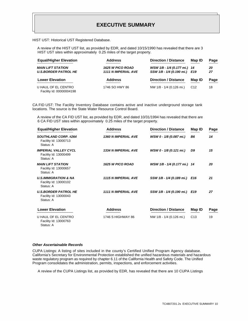
HIST UST: Historical UST Registered Database.
A review of the HIST UST list, as provided by EDR, and dated 10/15/1990 has revealed that there are 3 HIST UST sites within approximately 0.25 miles of the target property.
PageMap IDDirection / Distance Address Equal/Higher Elevation ____________________ ________ ___________________ _____ _____
MAIN LIFT STATION 1625 W PICO ROAD WSW 1/8 - 1/4 (0.177 mi.) 14 20 U.S.BORDER PATROL HE 1111 N IMPERIAL AVE SSW 1/8 - 1/4 (0.190 mi.) E19 27
PageMap IDDirection / Distance Address Lower Elevation ____________________ ________ ___________________ _____ _____
U HAUL OF EL CENTRO 1746 SO HWY 86 NW 1/8 - 1/4 (0.126 mi.) C12 18Facility Id: 00000004198
CA FID UST: The Facility Inventory Database contains active and inactive underground storage tanklocations. The source is the State Water Resource Control Board.
A review of the CA FID UST list, as provided by EDR, and dated 10/31/1994 has revealed that there are 6 CA FID UST sites within approximately 0.25 miles of the target property.
PageMap IDDirection / Distance Address Equal/Higher Elevation ____________________ ________ ___________________ _____ _____
SOUTHLAND CORP. #264 1360 N IMPERIAL AVE WSW 0 - 1/8 (0.087 mi.) B6 14Facility Id: 13000713Status: A
IMPERIAL VALLEY CYCL 1334 N IMPERIAL AVE WSW 0 - 1/8 (0.121 mi.) D9 15Facility Id: 13000499Status: A
MAIN LIFT STATION 1625 W PICO ROAD WSW 1/8 - 1/4 (0.177 mi.) 14 20Facility Id: 13000657Status: A
U.S.IMMIGRATION & NA 1115 N IMPERIAL AVE SSW 1/8 - 1/4 (0.189 mi.) E16 21Facility Id: 13000102Status: A
U.S.BORDER PATROL HE 1111 N IMPERIAL AVE SSW 1/8 - 1/4 (0.190 mi.) E19 27Facility Id: 13000043Status: A
PageMap IDDirection / Distance Address Lower Elevation ____________________ ________ ___________________ _____ _____
U HAUL OF EL CENTRO 1746 S HIGHWAY 86 NW 1/8 - 1/4 (0.126 mi.) C13 19Facility Id: 13000763Status: A
Other Ascertainable Records
CUPA Listings: A listing of sites included in the county’s Certified Unified Program Agency database. California’s Secretary for Environmental Protection established the unified hazardous materials and hazardouswaste regulatory program as required by chapter 6.11 of the California Health and Safety Code. The UnifiedProgram consolidates the administration, permits, inspections, and enforcement activities.
A review of the CUPA Listings list, as provided by EDR, has revealed that there are 10 CUPA Listings

EXECUTIVE SUMMARY
TC4807201.2s EXECUTIVE SUMMARY 11
sites within approximately 0.25 miles of the target property.
PageMap IDDirection / Distance Address Equal/Higher Elevation ____________________ ________ ___________________ _____ _____
IMPERIAL VALLEY PODI 1503 N IMPERIAL AVE WNW 0 - 1/8 (0.037 mi.) A1 8Database: CUPA IMPERIAL, Date of Government Version: 10/24/2016
WESTERN DENTAL CENTE 1450 N IMPERIAL AVE WSW 0 - 1/8 (0.078 mi.) B2 9Database: CUPA IMPERIAL, Date of Government Version: 10/24/2016
BRAWLEY ENDOSCOPY DB 1550 N IMPERIAL AVE W 0 - 1/8 (0.079 mi.) A3 11Database: CUPA IMPERIAL, Date of Government Version: 10/24/2016
CARDENAS MARKETS, IN 1620 N IMPERIAL AVE NW 0 - 1/8 (0.092 mi.) C7 15Database: CUPA IMPERIAL, Date of Government Version: 10/24/2016
SMART & FINAL #461 1290 N IMPERIAL AVE SW 0 - 1/8 (0.111 mi.) D8 15Database: CUPA IMPERIAL, Date of Government Version: 10/24/2016
IMPERIAL VALLEY CYCL 1334 N IMPERIAL AVE WSW 0 - 1/8 (0.121 mi.) D10 16Database: CUPA IMPERIAL, Date of Government Version: 10/24/2016
U.S.IMMIGRATION & NA 1115 N IMPERIAL AVE SSW 1/8 - 1/4 (0.189 mi.) E16 21Database: CUPA IMPERIAL, Date of Government Version: 10/24/2016
U.S.BORDER PATROL HE 1111 N IMPERIAL AVE SSW 1/8 - 1/4 (0.190 mi.) E19 27Database: CUPA IMPERIAL, Date of Government Version: 10/24/2016
PageMap IDDirection / Distance Address Lower Elevation ____________________ ________ ___________________ _____ _____
HARBOR FREIGHT TOOL 1750 N IMPERIAL AVE NW 1/8 - 1/4 (0.201 mi.) F23 34Database: CUPA IMPERIAL, Date of Government Version: 10/24/2016
KMART #3151 1950 N IMPERIAL AVE NNW 1/8 - 1/4 (0.203 mi.) 24 34Database: CUPA IMPERIAL, Date of Government Version: 10/24/2016
HIST CORTESE: The sites for the list are designated by the State Water Resource Control Board [LUST],the Integrated Waste Board [SWF/LS], and the Department of Toxic Substances Control [CALSITES]. Thislisting is no longer updated by the state agency.
A review of the HIST CORTESE list, as provided by EDR, and dated 04/01/2001 has revealed that there are 3 HIST CORTESE sites within approximately 0.5 miles of the target property.
PageMap IDDirection / Distance Address Equal/Higher Elevation ____________________ ________ ___________________ _____ _____
7 ELEVEN STORE NO .2 1360 NORTH IMPERIAL WSW 0 - 1/8 (0.087 mi.) B4 12Reg Id: 7T2243058
COYNE (VACANT LOT) 1334 IMPERIAL WSW 0 - 1/8 (0.121 mi.) D11 17Reg Id: 7T2243027
EL CENTRO MAIN SEWER 1675 PICO WSW 1/4 - 1/2 (0.284 mi.) G26 36Reg Id: 7T2243016
HWP: Detailed information on permitted hazardous waste facilities and corrective action("cleanups") tracked in EnviroStor.
A review of the HWP list, as provided by EDR, and dated 08/22/2016 has revealed that there is 1 HWP site within approximately 1 mile of the target property.
EXECUTIVE SUMMARY
TC4807201.2s EXECUTIVE SUMMARY 12
PageMap IDDirection / Distance Address Equal/Higher Elevation ____________________ ________ ___________________ _____ _____
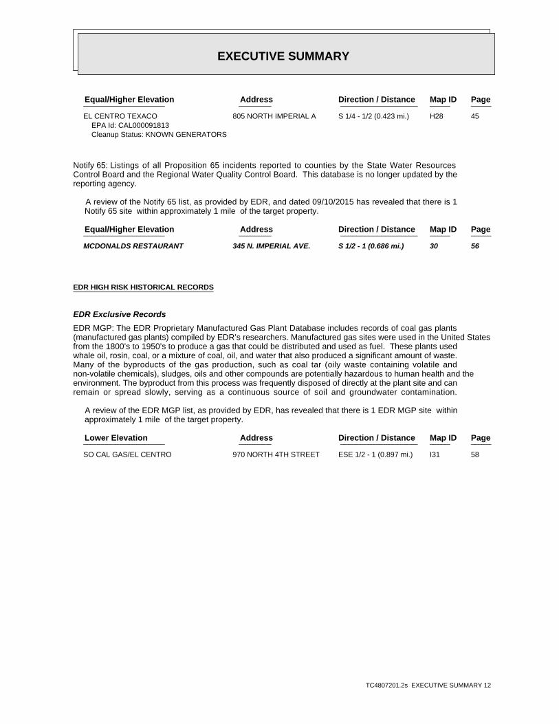
EL CENTRO TEXACO 805 NORTH IMPERIAL A S 1/4 - 1/2 (0.423 mi.) H28 45EPA Id: CAL000091813Cleanup Status: KNOWN GENERATORS
Notify 65: Listings of all Proposition 65 incidents reported to counties by the State Water ResourcesControl Board and the Regional Water Quality Control Board. This database is no longer updated by thereporting agency.
A review of the Notify 65 list, as provided by EDR, and dated 09/10/2015 has revealed that there is 1 Notify 65 site within approximately 1 mile of the target property.
PageMap IDDirection / Distance Address Equal/Higher Elevation ____________________ ________ ___________________ _____ _____
MCDONALDS RESTAURANT 345 N. IMPERIAL AVE. S 1/2 - 1 (0.686 mi.) 30 56
EDR HIGH RISK HISTORICAL RECORDS
EDR Exclusive Records
EDR MGP: The EDR Proprietary Manufactured Gas Plant Database includes records of coal gas plants(manufactured gas plants) compiled by EDR’s researchers. Manufactured gas sites were used in the United Statesfrom the 1800’s to 1950’s to produce a gas that could be distributed and used as fuel. These plants usedwhale oil, rosin, coal, or a mixture of coal, oil, and water that also produced a significant amount of waste.Many of the byproducts of the gas production, such as coal tar (oily waste containing volatile andnon-volatile chemicals), sludges, oils and other compounds are potentially hazardous to human health and theenvironment. The byproduct from this process was frequently disposed of directly at the plant site and canremain or spread slowly, serving as a continuous source of soil and groundwater contamination.
A review of the EDR MGP list, as provided by EDR, has revealed that there is 1 EDR MGP site within approximately 1 mile of the target property.
PageMap IDDirection / Distance Address Lower Elevation ____________________ ________ ___________________ _____ _____
SO CAL GAS/EL CENTRO 970 NORTH 4TH STREET ESE 1/2 - 1 (0.897 mi.) I31 58
EXECUTIVE SUMMARY
TC4807201.2s EXECUTIVE SUMMARY 13
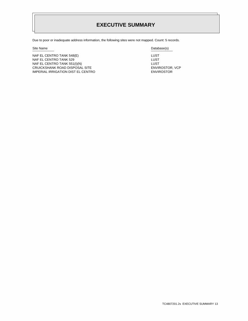
Due to poor or inadequate address information, the following sites were not mapped. Count: 5 records.
Site Name Database(s)____________ ____________
NAF EL CENTRO TANK 548(E) LUSTNAF EL CENTRO TANK 529 LUSTNAF EL CENTRO TANK 551(I)(N) LUSTCRUICKSHANK ROAD DISPOSAL SITE ENVIROSTOR, VCPIMPERIAL IRRIGATION DIST EL CENTRO ENVIROSTOR

EDR Inc.EDR Inc.EDR Inc.EDR Inc.EDR Inc.EDR Inc.EDR Inc.EDR Inc.EDR Inc.EDR Inc.EDR Inc.EDR Inc.EDR Inc.EDR Inc.EDR Inc.EDR Inc.EDR Inc.EDR Inc.EDR Inc.EDR Inc.EDR Inc.EDR Inc.EDR Inc.EDR Inc.EDR Inc.EDR Inc.EDR Inc.EDR Inc.EDR Inc.EDR Inc.EDR Inc.EDR Inc.EDR Inc.EDR Inc.EDR Inc.EDR Inc.EDR Inc.EDR Inc.EDR Inc.EDR Inc.
34 kV
60 kV
Natural G
as
- 4 0
-4
0
-40
- 4 0
-40
-40

EDR Inc.EDR Inc.EDR Inc.EDR Inc.EDR Inc.EDR Inc.EDR Inc.EDR Inc.EDR Inc.EDR Inc.EDR Inc.EDR Inc.EDR Inc.EDR Inc.EDR Inc.EDR Inc.EDR Inc.EDR Inc.EDR Inc.EDR Inc.EDR Inc.EDR Inc.EDR Inc.EDR Inc.EDR Inc.EDR Inc.EDR Inc.EDR Inc.EDR Inc.EDR Inc.EDR Inc.EDR Inc.EDR Inc.EDR Inc.EDR Inc.EDR Inc.EDR Inc.EDR Inc.EDR Inc.EDR Inc.
-40

MAP FINDINGS SUMMARY
SearchTargetDistance Total
Database Property(Miles) < 1/8 1/8 - 1/4 1/4 - 1/2 1/2 - 1 > 1 Plotted
STANDARD ENVIRONMENTAL RECORDS
Federal NPL site list
0 NR 0 0 0 0 1.000NPL 0 NR 0 0 0 0 1.000Proposed NPL 0 NR NR NR NR 0 0.001NPL LIENS
Federal Delisted NPL site list
0 NR 0 0 0 0 1.000Delisted NPL
Federal CERCLIS list
0 NR NR 0 0 0 0.500FEDERAL FACILITY 0 NR NR 0 0 0 0.500SEMS
Federal CERCLIS NFRAP site list
0 NR NR 0 0 0 0.500SEMS-ARCHIVE
Federal RCRA CORRACTS facilities list
0 NR 0 0 0 0 1.000CORRACTS
Federal RCRA non-CORRACTS TSD facilities list
0 NR NR 0 0 0 0.500RCRA-TSDF
Federal RCRA generators list
0 NR NR NR 0 0 0.250RCRA-LQG 2 NR NR NR 2 0 0.250RCRA-SQG 0 NR NR NR 0 0 0.250RCRA-CESQG
Federal institutional controls /engineering controls registries
0 NR NR 0 0 0 0.500LUCIS 0 NR NR 0 0 0 0.500US ENG CONTROLS 0 NR NR 0 0 0 0.500US INST CONTROL
Federal ERNS list
0 NR NR NR NR 0 0.001ERNS
State- and tribal - equivalent NPL
0 NR 0 0 0 0 1.000RESPONSE
State- and tribal - equivalent CERCLIS
2 NR 2 0 0 0 1.000ENVIROSTOR
State and tribal landfill and/orsolid waste disposal site lists
0 NR NR 0 0 0 0.500SWF/LF
State and tribal leaking storage tank lists
7 NR NR 3 1 3 0.500LUST
TC4807201.2s Page 4

MAP FINDINGS SUMMARY
SearchTargetDistance Total
Database Property(Miles) < 1/8 1/8 - 1/4 1/4 - 1/2 1/2 - 1 > 1 Plotted
0 NR NR 0 0 0 0.500INDIAN LUST 0 NR NR 0 0 0 0.500SLIC
State and tribal registered storage tank lists
0 NR NR NR 0 0 0.250FEMA UST 1 NR NR NR 1 0 0.250UST 3 NR NR NR 3 0 0.250AST 0 NR NR NR 0 0 0.250INDIAN UST
State and tribal voluntary cleanup sites
0 NR NR 0 0 0 0.500INDIAN VCP 0 NR NR 0 0 0 0.500VCP
State and tribal Brownfields sites
0 NR NR 0 0 0 0.500BROWNFIELDS
ADDITIONAL ENVIRONMENTAL RECORDS
Local Brownfield lists
0 NR NR 0 0 0 0.500US BROWNFIELDS
Local Lists of Landfill / SolidWaste Disposal Sites
0 NR NR 0 0 0 0.500WMUDS/SWAT 0 NR NR 0 0 0 0.500SWRCY 0 NR NR NR NR 0 0.001HAULERS 0 NR NR 0 0 0 0.500INDIAN ODI 0 NR NR 0 0 0 0.500DEBRIS REGION 9 0 NR NR 0 0 0 0.500ODI 0 NR NR 0 0 0 0.500IHS OPEN DUMPS
Local Lists of Hazardous waste /Contaminated Sites
0 NR NR NR NR 0 0.001US HIST CDL 0 NR 0 0 0 0 1.000HIST Cal-Sites 0 NR NR NR 0 0 0.250SCH 0 NR NR NR NR 0 0.001CDL 0 NR 0 0 0 0 1.000Toxic Pits 0 NR NR NR NR 0 0.001US CDL
Local Lists of Registered Storage Tanks
4 NR NR NR 2 2 0.250SWEEPS UST 3 NR NR NR 3 0 0.250HIST UST 6 NR NR NR 4 2 0.250CA FID UST
Local Land Records
0 NR NR NR NR 0 0.001LIENS 0 NR NR NR NR 0 0.001LIENS 2 0 NR NR 0 0 0 0.500DEED
Records of Emergency Release Reports
0 NR NR NR NR 0 0.001HMIRS
TC4807201.2s Page 5

MAP FINDINGS SUMMARY
SearchTargetDistance Total
Database Property(Miles) < 1/8 1/8 - 1/4 1/4 - 1/2 1/2 - 1 > 1 Plotted
0 NR NR NR NR 0 0.001CHMIRS 0 NR NR NR NR 0 0.001LDS 0 NR NR NR NR 0 0.001MCS 0 NR NR NR NR 0 0.001SPILLS 90
Other Ascertainable Records
0 NR NR NR 0 0 0.250RCRA NonGen / NLR 0 NR 0 0 0 0 1.000FUDS 0 NR 0 0 0 0 1.000DOD 0 NR NR 0 0 0 0.500SCRD DRYCLEANERS 0 NR NR NR NR 0 0.001US FIN ASSUR 0 NR NR NR NR 0 0.001EPA WATCH LIST 0 NR NR NR 0 0 0.2502020 COR ACTION 0 NR NR NR NR 0 0.001TSCA 0 NR NR NR NR 0 0.001TRIS 0 NR NR NR NR 0 0.001SSTS 0 NR 0 0 0 0 1.000ROD 0 NR NR NR NR 0 0.001RMP 0 NR NR NR NR 0 0.001RAATS 0 NR NR NR NR 0 0.001PRP 0 NR NR NR NR 0 0.001PADS 0 NR NR NR NR 0 0.001ICIS 0 NR NR NR NR 0 0.001FTTS 0 NR NR NR NR 0 0.001MLTS 0 NR NR NR NR 0 0.001COAL ASH DOE 0 NR NR 0 0 0 0.500COAL ASH EPA 0 NR NR NR NR 0 0.001PCB TRANSFORMER 0 NR NR NR NR 0 0.001RADINFO 0 NR NR NR NR 0 0.001HIST FTTS 0 NR NR NR NR 0 0.001DOT OPS 0 NR 0 0 0 0 1.000CONSENT 0 NR NR NR NR 0 0.001INDIAN RESERV 0 NR 0 0 0 0 1.000FUSRAP 0 NR NR 0 0 0 0.500UMTRA 0 NR NR NR NR 0 0.001LEAD SMELTERS 0 NR NR NR NR 0 0.001US AIRS 0 NR NR NR 0 0 0.250US MINES 0 NR NR NR NR 0 0.001FINDS 0 NR NR NR NR 0 0.001DOCKET HWC 0 NR 0 0 0 0 1.000UXO 0 NR 0 0 0 0 1.000CA BOND EXP. PLAN 0 NR NR 0 0 0 0.500Cortese 10 NR NR NR 4 6 0.250CUPA Listings 0 NR NR NR 0 0 0.250DRYCLEANERS 0 NR NR NR NR 0 0.001EMI 0 NR NR NR NR 0 0.001ENF 0 NR NR NR NR 0 0.001Financial Assurance 0 NR NR NR NR 0 0.001HAZNET 3 NR NR 1 0 2 0.500HIST CORTESE 1 NR 0 1 0 0 1.000HWP 0 NR NR NR 0 0 0.250HWT
TC4807201.2s Page 6

MAP FINDINGS SUMMARY
SearchTargetDistance Total
Database Property(Miles) < 1/8 1/8 - 1/4 1/4 - 1/2 1/2 - 1 > 1 Plotted
0 NR NR NR NR 0 0.001MINES 0 NR NR NR 0 0 0.250MWMP 0 NR NR NR NR 0 0.001NPDES 0 NR NR NR NR 0 0.001PEST LIC 0 NR NR 0 0 0 0.500PROC 1 NR 1 0 0 0 1.000Notify 65 0 NR NR NR NR 0 0.001UIC 0 NR NR 0 0 0 0.500WASTEWATER PITS 0 NR NR NR NR 0 0.001WDS 0 NR NR NR 0 0 0.250WIP 0 NR NR NR 0 0 0.250FUELS PROGRAM 0 NR NR NR NR NR TPABANDONED MINES 0 NR NR NR NR NR TPICE 0 NR NR NR NR 0 0.001ECHO
EDR HIGH RISK HISTORICAL RECORDS
EDR Exclusive Records
1 NR 1 0 0 0 1.000EDR MGP 0 NR NR NR NR 0 0.125EDR Hist Auto 0 NR NR NR NR 0 0.125EDR Hist Cleaner
EDR RECOVERED GOVERNMENT ARCHIVES
Exclusive Recovered Govt. Archives
0 NR NR NR NR 0 0.001RGA LF 0 NR NR NR NR 0 0.001RGA LUST
44 0 4 5 20 15 0- Totals --
NOTES:
TP = Target Property
NR = Not Requested at this Search Distance
Sites may be listed in more than one database
TC4807201.2s Page 7
MAP FINDINGSMap IDDirection
EDR ID NumberDistanceEPA ID NumberDatabase(s)SiteElevation
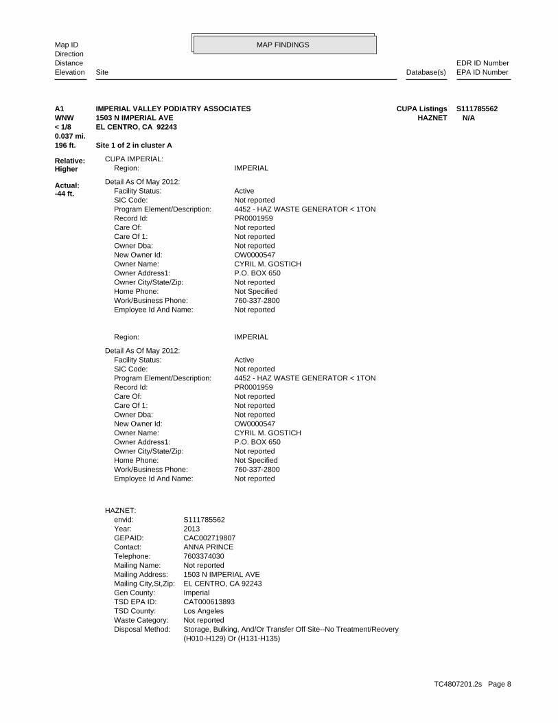
(H010-H129) Or (H131-H135) Storage, Bulking, And/Or Transfer Off Site--No Treatment/ReoveryDisposal Method: Not reportedWaste Category: Los AngelesTSD County: CAT000613893TSD EPA ID: ImperialGen County: EL CENTRO, CA 92243Mailing City,St,Zip: 1503 N IMPERIAL AVEMailing Address: Not reportedMailing Name: 7603374030Telephone: ANNA PRINCEContact: CAC002719807GEPAID: 2013Year: S111785562envid:
HAZNET:
Not reportedEmployee Id And Name: 760-337-2800Work/Business Phone: Not SpecifiedHome Phone: Not reportedOwner City/State/Zip: P.O. BOX 650Owner Address1: CYRIL M. GOSTICHOwner Name: OW0000547New Owner Id: Not reportedOwner Dba: Not reportedCare Of 1: Not reportedCare Of: PR0001959Record Id: 4452 - HAZ WASTE GENERATOR < 1TONProgram Element/Description: Not reportedSIC Code: ActiveFacility Status:
Detail As Of May 2012:
IMPERIALRegion:
Not reportedEmployee Id And Name: 760-337-2800Work/Business Phone: Not SpecifiedHome Phone: Not reportedOwner City/State/Zip: P.O. BOX 650Owner Address1: CYRIL M. GOSTICHOwner Name: OW0000547New Owner Id: Not reportedOwner Dba: Not reportedCare Of 1: Not reportedCare Of: PR0001959Record Id: 4452 - HAZ WASTE GENERATOR < 1TONProgram Element/Description: Not reportedSIC Code: ActiveFacility Status:
Detail As Of May 2012:
IMPERIALRegion:CUPA IMPERIAL:
196 ft. Site 1 of 2 in cluster A0.037 mi.
Relative:Higher
Actual:-44 ft.
< 1/8 EL CENTRO, CA 92243WNW HAZNET1503 N IMPERIAL AVE N/AA1 CUPA ListingsIMPERIAL VALLEY PODIATRY ASSOCIATES S111785562
TC4807201.2s Page 8

MAP FINDINGSMap IDDirection
EDR ID NumberDistanceEPA ID NumberDatabase(s)SiteElevation
Not reportedFacility County: (H010-H129) Or (H131-H135) Storage, Bulking, And/Or Transfer Off Site--No Treatment/ReoveryMethod Decode: Not reportedCat Decode: 0.15Tons:
IMPERIAL VALLEY PODIATRY ASSOCIATES (Continued) S111785562
S113139465envid:
Not reportedFacility County: (H010-H129) Or (H131-H135) Storage, Bulking, And/Or Transfer Off Site--No Treatment/ReoveryMethod Decode: Not reportedCat Decode: 0.02085Tons: (H010-H129) Or (H131-H135) Storage, Bulking, And/Or Transfer Off Site--No Treatment/ReoveryDisposal Method: Not reportedWaste Category: Los AngelesTSD County: CAD044429835TSD EPA ID: ImperialGen County: ORANGE, CA 928630000Mailing City,St,Zip: 530 S MAIN STREETMailing Address: Not reportedMailing Name: 7145712189Telephone: Yen LamContact: CAL000299498GEPAID: 2013Year: S113139465envid:
Not reportedFacility County: (H010-H129) Or (H131-H135) Storage, Bulking, And/Or Transfer Off Site--No Treatment/ReoveryMethod Decode: Not reportedCat Decode: 0.017Tons: (H010-H129) Or (H131-H135) Storage, Bulking, And/Or Transfer Off Site--No Treatment/ReoveryDisposal Method: Not reportedWaste Category: Los AngelesTSD County: CAD044429835TSD EPA ID: ImperialGen County: ORANGE, CA 928630000Mailing City,St,Zip: 530 S MAIN STREETMailing Address: Not reportedMailing Name: 7145712189Telephone: Yen LamContact: CAL000299498GEPAID: 2013Year: S113139465envid:
HAZNET:
IMPERIALRegion:CUPA IMPERIAL:
410 ft. Site 1 of 4 in cluster B0.078 mi.
Relative:Higher
Actual:-43 ft.
< 1/8 EL CENTRO, CA 92243WSW HAZNET1450 N IMPERIAL AVE N/AB2 CUPA ListingsWESTERN DENTAL CENTERS S113139465
TC4807201.2s Page 9

MAP FINDINGSMap IDDirection
EDR ID NumberDistanceEPA ID NumberDatabase(s)SiteElevation
ImperialFacility County: Not reportedMethod Decode: Unspecified aqueous solutionCat Decode: 0.021Tons: Not reportedDisposal Method: Unspecified aqueous solutionWaste Category: Not reportedTSD County: CAD028409019TSD EPA ID: Not reportedGen County: ORANGE, CA 928630000Mailing City,St,Zip: 530 S MAIN STREET PO BOX 14227Mailing Address: Not reportedMailing Name: 7145713567Telephone: EDWARD SALDONAContact: CAL000299498GEPAID: 2008Year: S113139465envid:
ImperialFacility County: (H010-H129) Or (H131-H135) Storage, Bulking, And/Or Transfer Off Site--No Treatment/ReoveryMethod Decode: Unspecified organic liquid mixtureCat Decode: 0.034Tons: (H010-H129) Or (H131-H135) Storage, Bulking, And/Or Transfer Off Site--No Treatment/ReoveryDisposal Method: Unspecified organic liquid mixtureWaste Category: Not reportedTSD County: CAD044429835TSD EPA ID: Not reportedGen County: ORANGE, CA 928630000Mailing City,St,Zip: 530 S MAIN STMailing Address: Not reportedMailing Name: 7145713502Telephone: EDWARD SALDANA, FACILITIES MGRContact: CAL000299498GEPAID: 2010Year: S113139465envid:
ImperialFacility County: (H010-H129) Or (H131-H135) Storage, Bulking, And/Or Transfer Off Site--No Treatment/ReoveryMethod Decode: Not reportedCat Decode: 0.051Tons: (H010-H129) Or (H131-H135) Storage, Bulking, And/Or Transfer Off Site--No Treatment/ReoveryDisposal Method: Not reportedWaste Category: Los AngelesTSD County: CAD044429835TSD EPA ID: ImperialGen County: ORANGE, CA 928630000Mailing City,St,Zip: 530 S MAIN STMailing Address: Not reportedMailing Name: 7145713502Telephone: EDWARD SALDANA, FACILITIES MGRContact: CAL000299498GEPAID: 2012Year:
WESTERN DENTAL CENTERS (Continued) S113139465
TC4807201.2s Page 10
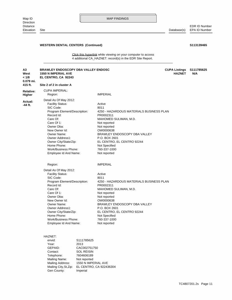
MAP FINDINGSMap IDDirection
EDR ID NumberDistanceEPA ID NumberDatabase(s)SiteElevation
4 additional CA_HAZNET: record(s) in the EDR Site Report.Click this hyperlink while viewing on your computer to access
WESTERN DENTAL CENTERS (Continued) S113139465
ImperialGen County: EL CENTRO, CA 922436304Mailing City,St,Zip: 1550 N IMPERIAL AVEMailing Address: Not reportedMailing Name: 7604606189Telephone: SOL REISINContact: CAC002751750GEPAID: 2013Year: S111785625envid:
HAZNET:
Not reportedEmployee Id And Name: 760-337-1000Work/Business Phone: Not SpecifiedHome Phone: EL CENTRO, EL CENTRO 92244Owner City/State/Zip: P.O. BOX 2601Owner Address1: BRAWLEY ENDOSCOPY DBA VALLEYOwner Name: OW0000638New Owner Id: Not reportedOwner Dba: Not reportedCare Of 1: MAHOMED SULIMAN, M.D.Care Of: PR0002311Record Id: 4250 - HAZARDOUS MATERIALS BUSINESS PLANProgram Element/Description: 8011SIC Code: ActiveFacility Status:
Detail As Of May 2012:
IMPERIALRegion:
Not reportedEmployee Id And Name: 760-337-1000Work/Business Phone: Not SpecifiedHome Phone: EL CENTRO, EL CENTRO 92244Owner City/State/Zip: P.O. BOX 2601Owner Address1: BRAWLEY ENDOSCOPY DBA VALLEYOwner Name: OW0000638New Owner Id: Not reportedOwner Dba: Not reportedCare Of 1: MAHOMED SULIMAN, M.D.Care Of: PR0002311Record Id: 4250 - HAZARDOUS MATERIALS BUSINESS PLANProgram Element/Description: 8011SIC Code: ActiveFacility Status:
Detail As Of May 2012:
IMPERIALRegion:CUPA IMPERIAL:
415 ft. Site 2 of 2 in cluster A0.079 mi.
Relative:Higher
Actual:-44 ft.
< 1/8 EL CENTRO, CA 92243West HAZNET1550 N IMPERIAL AVE N/AA3 CUPA ListingsBRAWLEY ENDOSCOPY DBA VALLEY ENDOSC S111785625
TC4807201.2s Page 11

MAP FINDINGSMap IDDirection
EDR ID NumberDistanceEPA ID NumberDatabase(s)SiteElevation
Not reportedFacility County: Include On-Site Treatment And/Or Stabilization) Landfill Or Surface Impoundment That Will Be Closed As Landfill( ToMethod Decode: Not reportedCat Decode: 0.2Tons: Include On-Site Treatment And/Or Stabilization) Landfill Or Surface Impoundment That Will Be Closed As Landfill( ToDisposal Method: Not reportedWaste Category: 99TSD County: NVT330010000TSD EPA ID:
BRAWLEY ENDOSCOPY DBA VALLEY ENDOSC (Continued) S111785625
T0602500108Global Id:Status History:
Not reportedPhone Number: Not reportedEmail: EL CENTROCity: 939 MAIN STRRETAddress: IMPERIAL COUNTYOrganization Name: JERRY STILWELLContact Name: Local Agency CaseworkerContact Type: T0602500108Global Id:
7607768986Phone Number: [email protected]: PALM DESERTCity: 73-720 FRED WARING DRIVE, SUIE 100Address: COLORADO RIVER BASIN RWQCB (REGION 7)Organization Name: KOLA OLATUNBOSUNContact Name: Regional Board CaseworkerContact Type: T0602500108Global Id:
Contact:
Click here to access the California GeoTracker records for this facility:
Not reportedSite History: GasolinePotential Contaminants of Concern: SoilPotential Media Affect: Not reportedFile Location: Not reportedLOC Case Number: 7T2243058RB Case Number: IMPERIAL COUNTYLocal Agency: KOCase Worker: COLORADO RIVER BASIN RWQCB (REGION 7)Lead Agency: 05/03/1995Status Date: Completed - Case ClosedStatus: LUST Cleanup SiteCase Type: -115.5657659Longitude: 32.8076118Latitude: T0602500108Global Id: STATERegion:
LUST:
462 ft. Site 2 of 4 in cluster B0.087 mi.
Relative:Higher
Actual:-43 ft.
< 1/8 EL CENTRO, CA 92243WSW HIST CORTESE1360 NORTH IMPERIAL AVENUE N/AB4 LUST7 ELEVEN STORE NO .26400 S105023589
TC4807201.2s Page 12

MAP FINDINGSMap IDDirection
EDR ID NumberDistanceEPA ID NumberDatabase(s)SiteElevation
7T2243058Reg Id: LTNKAReg By: 13Facility County Code: CORTESERegion:
HIST CORTESE:
Leak DiscoveryAction: 09/13/1994Date: OtherAction Type: T0602500108Global Id:
Leak ReportedAction: 12/20/1994Date: OtherAction Type: T0602500108Global Id:
Leak StoppedAction: 09/13/1994Date: OtherAction Type: T0602500108Global Id:
Regulatory Activities:
09/13/1994Status Date: Open - Case Begin DateStatus: T0602500108Global Id:
05/03/1995Status Date: Completed - Case ClosedStatus:
7 ELEVEN STORE NO .26400 (Continued) S105023589
GSCase Worker:Regional BoardLead Agency:T0602500108Global ID:390ID:Gasoline - AutomotiveSubstance:7T2243058Case Num:9 - Case ClosedStatus:7Region:
LUST REG 7:
462 ft. Site 3 of 4 in cluster B0.087 mi.
Relative:Higher
Actual:-43 ft.
< 1/8 EL CENTRO, CA WSW 1360 NORTH IMPERIAL AVENUE N/AB5 LUST7 ELEVEN STORE NO .26400 S104816292
TC4807201.2s Page 13

MAP FINDINGSMap IDDirection
EDR ID NumberDistanceEPA ID NumberDatabase(s)SiteElevation
Not reportedNumber Of Tanks: LEADEDContent: PSTG: M.V. FUELTank Use: 08-08-90Active Date: 9728Capacity: ATank Status: 13-000-000210-000003SWRCB Tank Id: 3Owner Tank Id: 12-29-89Created Date: 02-08-93Action Date: 02-08-93Referral Date: Not reportedBoard Of Equalization: 1Number: 210Comp Number: ActiveStatus:
Not reportedNumber Of Tanks: LEADEDContent: PSTG: M.V. FUELTank Use: 08-08-90Active Date: 9728Capacity: ATank Status: 13-000-000210-000002SWRCB Tank Id: 2Owner Tank Id: 12-29-89Created Date: 02-08-93Action Date: 02-08-93Referral Date: Not reportedBoard Of Equalization: 1Number: 210Comp Number: ActiveStatus:
3Number Of Tanks: REG UNLEADEDContent: PSTG: M.V. FUELTank Use: 08-08-90Active Date: 9728Capacity: ATank Status: 13-000-000210-000001SWRCB Tank Id: 1Owner Tank Id: 12-29-89Created Date: 02-08-93Action Date: 02-08-93Referral Date: Not reportedBoard Of Equalization: 1Number: 210Comp Number: ActiveStatus:
SWEEPS UST:
462 ft. Site 4 of 4 in cluster B0.087 mi.
Relative:Higher
Actual:-43 ft.
< 1/8 EL CENTRO, CA 92243WSW CA FID UST1360 N IMPERIAL AVE N/AB6 SWEEPS USTSOUTHLAND CORP. #26400/7-11 STORES S101582206
TC4807201.2s Page 14

MAP FINDINGSMap IDDirection
EDR ID NumberDistanceEPA ID NumberDatabase(s)SiteElevation
ActiveStatus: Not reportedComments: Not reportedEPA ID: Not reportedNPDES Number: Not reportedDUNs Number: Not reportedContact Phone: Not reportedContact: EL CENTRO 92243Mailing City,St,Zip: Not reportedMailing Address 2: 16835 W BERNARDO DRMailing Address: Not reportedMail To: 6192681070Facility Phone: Not reportedSIC Code: Not reportedCortese Code: Not reportedRegulated ID: UTNKARegulated By: 13000713Facility ID:
CA FID UST:
SOUTHLAND CORP. #26400/7-11 STORES (Continued) S101582206
IMPERIALRegion:CUPA IMPERIAL:
487 ft. Site 1 of 3 in cluster C0.092 mi.
Relative:Higher
Actual:-44 ft.
< 1/8 EL CENTRO, CA 92243NW 1620 N IMPERIAL AVE N/AC7 CUPA ListingsCARDENAS MARKETS, INC. #23 S118099829
IMPERIALRegion:CUPA IMPERIAL:
587 ft. Site 1 of 4 in cluster D0.111 mi.
Relative:Higher
Actual:-42 ft.
< 1/8 EL CENTRO, CA 92243SW 1290 N IMPERIAL AVE N/AD8 CUPA ListingsSMART & FINAL #461 S117726280
ATank Status: 13-000-000289-000001SWRCB Tank Id: 1Owner Tank Id: 12-27-89Created Date: 01-20-93Action Date: 01-20-93Referral Date: Not reportedBoard Of Equalization: 2Number: 289Comp Number: ActiveStatus:
SWEEPS UST:
638 ft. Site 2 of 4 in cluster D0.121 mi.
Relative:Higher
Actual:-42 ft.
< 1/8 EL CENTRO, CA 92243WSW CA FID UST1334 N IMPERIAL AVE N/AD9 SWEEPS USTIMPERIAL VALLEY CYCLE CENTER/MARTIN COYNE S101582199
TC4807201.2s Page 15

MAP FINDINGSMap IDDirection
EDR ID NumberDistanceEPA ID NumberDatabase(s)SiteElevation
ActiveStatus: Not reportedComments: Not reportedEPA ID: Not reportedNPDES Number: Not reportedDUNs Number: Not reportedContact Phone: Not reportedContact: EL CENTRO 92243Mailing City,St,Zip: Not reportedMailing Address 2: 1334 N IMPERIAL AVEMailing Address: Not reportedMail To: 6193532110Facility Phone: Not reportedSIC Code: Not reportedCortese Code: Not reportedRegulated ID: UTNKARegulated By: 13000499Facility ID:
CA FID UST:
1Number Of Tanks: WASTE OILContent: WSTG: OILTank Use: 08-09-90Active Date: 550Capacity:
IMPERIAL VALLEY CYCLE CENTER/MARTIN COYNE (Continued) S101582199
Not reportedEmployee Id And Name: 760-353-2110Work/Business Phone: Not SpecifiedHome Phone: EL CENTRO, EL CENTRO 92243Owner City/State/Zip: 1334 N IMPERIAL AVEOwner Address1: MARTIN D. COYNEOwner Name: OW0000283New Owner Id: Not reportedOwner Dba: MARTIN D. COYNECare Of 1: MARTIN D. COYNECare Of: PR0001001Record Id: 4452 - HAZ WASTE GENERATOR < 1TONProgram Element/Description: 4412SIC Code: ActiveFacility Status:
Detail As Of May 2012:
IMPERIALRegion:CUPA IMPERIAL:
638 ft. Site 3 of 4 in cluster D0.121 mi.
Relative:Higher
Actual:-42 ft.
< 1/8 EL CENTRO, CA 92243WSW 1334 N IMPERIAL AVE N/AD10 CUPA ListingsIMPERIAL VALLEY CYCLE CENTER, INC. S100864486
TC4807201.2s Page 16

MAP FINDINGSMap IDDirection
EDR ID NumberDistanceEPA ID NumberDatabase(s)SiteElevation
Leak StoppedAction: 04/07/1988Date: OtherAction Type: T0602500082Global Id:
Regulatory Activities:
03/02/1988Status Date: Open - Case Begin DateStatus: T0602500082Global Id:
07/24/1992Status Date: Completed - Case ClosedStatus: T0602500082Global Id:
Status History:
Not reportedPhone Number: Not reportedEmail: EL CENTROCity: 939 MAIN STRRETAddress: IMPERIAL COUNTYOrganization Name: JERRY STILWELLContact Name: Local Agency CaseworkerContact Type: T0602500082Global Id:
7607768986Phone Number: [email protected]: PALM DESERTCity: 73-720 FRED WARING DRIVE, SUIE 100Address: COLORADO RIVER BASIN RWQCB (REGION 7)Organization Name: KOLA OLATUNBOSUNContact Name: Regional Board CaseworkerContact Type: T0602500082Global Id:
Contact:
Click here to access the California GeoTracker records for this facility:
Not reportedSite History: Waste Oil / Motor / Hydraulic / LubricatingPotential Contaminants of Concern: SoilPotential Media Affect: Not reportedFile Location: Not reportedLOC Case Number: 7T2243027RB Case Number: IMPERIAL COUNTYLocal Agency: KOCase Worker: COLORADO RIVER BASIN RWQCB (REGION 7)Lead Agency: 07/24/1992Status Date: Completed - Case ClosedStatus: LUST Cleanup SiteCase Type: -115.5657659Longitude: 32.8076118Latitude: T0602500082Global Id: STATERegion:
LUST:
638 ft. Site 4 of 4 in cluster D0.121 mi.
Relative:Higher
Actual:-42 ft.
< 1/8 EL CENTRO, CA 92243WSW HIST CORTESE1334 IMPERIAL N/AD11 LUSTCOYNE (VACANT LOT) S105023588
TC4807201.2s Page 17

MAP FINDINGSMap IDDirection
EDR ID NumberDistanceEPA ID NumberDatabase(s)SiteElevation
7T2243027Reg Id: LTNKAReg By: 13Facility County Code: CORTESERegion:
HIST CORTESE:
GSCase Worker:Regional BoardLead Agency:T0602500082Global ID:678ID:Waste oil/Used oilSubstance:7T2243027Case Num:9 - Case ClosedStatus:7Region:
LUST REG 7:
Leak DiscoveryAction: 03/02/1988Date: OtherAction Type: T0602500082Global Id:
Leak ReportedAction: 06/06/1989Date: OtherAction Type: T0602500082Global Id:
COYNE (VACANT LOT) (Continued) S105023588
002Tank Num:
Stock InventorLeak Detection: Not reportedContainer Construction Thickness: REGULARType of Fuel: PRODUCTTank Used for: 00012000Tank Capacity: 1984Year Installed: 7178401Container Num: 001Tank Num:
0005Total Tanks: LEMON GROVE, CA 92045Owner City,St,Zip: 1805 MASSACHUSETTS AVEOwner Address: U-HAUL CO OF SAN DIEGOOwner Name: 6194844281Telephone: Not reportedContact Name: Not reportedOther Type: Gas StationFacility Type: 00000004198Facility ID: STATERegion: http://geotracker.waterboards.ca.gov/ustpdfs/pdf/00024082.pdfURL: 00024082File Number:
HIST UST:
665 ft. Site 2 of 3 in cluster C0.126 mi.
Relative:Lower
Actual:-45 ft.
1/8-1/4 EL CENTRO, CA 92243NW 1746 SO HWY 86 N/AC12 HIST USTU HAUL OF EL CENTRO U001573934
TC4807201.2s Page 18

MAP FINDINGSMap IDDirection
EDR ID NumberDistanceEPA ID NumberDatabase(s)SiteElevation
Click here for Geo Tracker PDF:
Groundwater Monitoring WellLeak Detection: Not reportedContainer Construction Thickness: WASTE OILType of Fuel: WASTETank Used for: 00000500Tank Capacity: 1984Year Installed: 7178405Container Num: 005Tank Num:
Stock InventorLeak Detection: Not reportedContainer Construction Thickness: DIESELType of Fuel: PRODUCTTank Used for: 00006000Tank Capacity: 1984Year Installed: 7178404Container Num: 004Tank Num:
Stock InventorLeak Detection: Not reportedContainer Construction Thickness: UNLEADEDType of Fuel: PRODUCTTank Used for: 00010000Tank Capacity: 1984Year Installed: 7178403Container Num: 003Tank Num:
Stock InventorLeak Detection: Not reportedContainer Construction Thickness: PREMIUMType of Fuel: PRODUCTTank Used for: 00010000Tank Capacity: 1984Year Installed: 7178402Container Num:
U HAUL OF EL CENTRO (Continued) U001573934
Not reportedNPDES Number: Not reportedDUNs Number: Not reportedContact Phone: Not reportedContact: EL CENTRO 92243Mailing City,St,Zip: Not reportedMailing Address 2: 1746 S HIGHWAY 86Mailing Address: Not reportedMail To: 6194844281Facility Phone: Not reportedSIC Code: Not reportedCortese Code: Not reportedRegulated ID: UTNKARegulated By: 13000763Facility ID:
CA FID UST:
665 ft. Site 3 of 3 in cluster C0.126 mi.
Relative:Lower
Actual:-45 ft.
1/8-1/4 EL CENTRO, CA 92243NW 1746 S HIGHWAY 86 N/AC13 CA FID USTU HAUL OF EL CENTRO S101619135
TC4807201.2s Page 19

MAP FINDINGSMap IDDirection
EDR ID NumberDistanceEPA ID NumberDatabase(s)SiteElevation
ActiveStatus: Not reportedComments: Not reportedEPA ID:
U HAUL OF EL CENTRO (Continued) S101619135
ActiveStatus: Not reportedComments: Not reportedEPA ID: Not reportedNPDES Number: Not reportedDUNs Number: Not reportedContact Phone: Not reportedContact: EL CENTRO 92243Mailing City,St,Zip: Not reportedMailing Address 2: P O BINMailing Address: Not reportedMail To: 6193524931Facility Phone: Not reportedSIC Code: Not reportedCortese Code: Not reportedRegulated ID: UTNKARegulated By: 13000657Facility ID:
CA FID UST:
Click here for Geo Tracker PDF:
Not reportedLeak Detection: Not reportedContainer Construction Thickness: Not reportedType of Fuel: Not reportedTank Used for: Not reportedTank Capacity: Not reportedYear Installed: Not reportedContainer Num: Not reportedTank Num:
Not reportedTotal Tanks: Not reportedOwner City,St,Zip: Not reportedOwner Address: Not reportedOwner Name: Not reportedTelephone: Not reportedContact Name: Not reportedOther Type: Not reportedFacility Type: Not reportedFacility ID: Not reportedRegion: http://geotracker.waterboards.ca.gov/ustpdfs/pdf/00023EA5.pdfURL: 00023EA5File Number:
HIST UST:
933 ft.0.177 mi.
Relative:Higher
Actual:-42 ft.
1/8-1/4 EL CENTRO, CA 92243WSW CA FID UST1625 W PICO ROAD N/A14 HIST USTMAIN LIFT STATION S101582204
TC4807201.2s Page 20

MAP FINDINGSMap IDDirection
EDR ID NumberDistanceEPA ID NumberDatabase(s)SiteElevation
CAL930273442EPAID: Not reportedProperty Owner Country: Not reportedProperty Owner Zip Code: Not reportedProperty Owner Stat : Not reportedProperty Owner City: Not reportedProperty Owner Mailing Address: Not reportedProperty Owner Phone: Not reportedProperty Owner Name: United StatesOwner Country: 92243Owner Zip Code: CAOwner State: 1115 N. Imperial Ave.Owner Mail Address: (760)336-4701Owner Phone: (760)336-4701Operator Phone: U.S. Immigration and Customs EnforcementOperator Name: 92243Mailing Address Zip Code: CAMailing Address State: El CentroMailing Address City: 1115 N. Imperial Ave.Mailing Address: Not reportedFax: (760)336-4701Phone: Immigration and Customs EnforcementBusiness Name: 13-000-0390Facility ID: 10124092CERSID: Not reportedTotal Gallons: U.S. Immigration and Customs EnforcementOwner: Not reportedCertified Unified Program Agencies:
AST:
1000 ft. Site 1 of 7 in cluster E0.189 mi.
Relative:Higher
Actual:-40 ft.
1/8-1/4 EL CENTRO, CA 92243SSW 1115 N. IMPERIAL AVE. N/AE15 ASTIMMIGRATION AND CUSTOMS ENFORCEMENT A100420951
ActiveStatus:
3Number Of Tanks: DIESELContent: PSTG: M.V. FUELTank Use: 10-23-90Active Date: 5000Capacity: ATank Status: 13-000-000107-000001SWRCB Tank Id: 1Owner Tank Id: 12-27-89Created Date: 03-12-93Action Date: 03-12-93Referral Date: Not reportedBoard Of Equalization: 7Number: 107Comp Number: ActiveStatus:
SWEEPS UST:
1000 ft. Site 2 of 7 in cluster E0.189 mi. HAZNET
Relative:Higher
Actual:-40 ft.
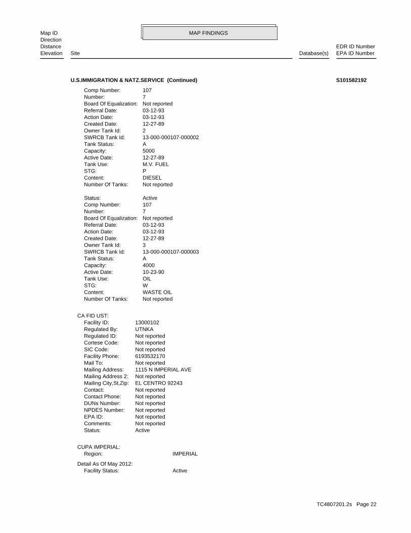
1/8-1/4 CUPA ListingsEL CENTRO, CA 92243SSW CA FID UST1115 N IMPERIAL AVE N/AE16 SWEEPS USTU.S.IMMIGRATION & NATZ.SERVICE S101582192
TC4807201.2s Page 21
MAP FINDINGSMap IDDirection
EDR ID NumberDistanceEPA ID NumberDatabase(s)SiteElevation
ActiveFacility Status:Detail As Of May 2012:
IMPERIALRegion:CUPA IMPERIAL:
ActiveStatus: Not reportedComments: Not reportedEPA ID: Not reportedNPDES Number: Not reportedDUNs Number: Not reportedContact Phone: Not reportedContact: EL CENTRO 92243Mailing City,St,Zip: Not reportedMailing Address 2: 1115 N IMPERIAL AVEMailing Address: Not reportedMail To: 6193532170Facility Phone: Not reportedSIC Code: Not reportedCortese Code: Not reportedRegulated ID: UTNKARegulated By: 13000102Facility ID:
CA FID UST:
Not reportedNumber Of Tanks: WASTE OILContent: WSTG: OILTank Use: 10-23-90Active Date: 4000Capacity: ATank Status: 13-000-000107-000003SWRCB Tank Id: 3Owner Tank Id: 12-27-89Created Date: 03-12-93Action Date: 03-12-93Referral Date: Not reportedBoard Of Equalization: 7Number: 107Comp Number: ActiveStatus:
Not reportedNumber Of Tanks: DIESELContent: PSTG: M.V. FUELTank Use: 12-27-89Active Date: 5000Capacity: ATank Status: 13-000-000107-000002SWRCB Tank Id: 2Owner Tank Id: 12-27-89Created Date: 03-12-93Action Date: 03-12-93Referral Date: Not reportedBoard Of Equalization: 7Number: 107Comp Number:
U.S.IMMIGRATION & NATZ.SERVICE (Continued) S101582192
TC4807201.2s Page 22

MAP FINDINGSMap IDDirection
EDR ID NumberDistanceEPA ID NumberDatabase(s)SiteElevation
Not reportedFacility County: Organics Recovery Ect Other Recovery Of Reclamation For Reuse Including Acid Regeneration,Method Decode: Not reportedCat Decode: 2.2935Tons: Organics Recovery Ect Other Recovery Of Reclamation For Reuse Including Acid Regeneration,Disposal Method: Not reportedWaste Category: Los AngelesTSD County: CAT080013352TSD EPA ID: ImperialGen County: CULVER CITY, CA 902322812Mailing City,St,Zip: 4144 IRVING PLMailing Address: Not reportedMailing Name: 3108760572Telephone: DAN MILDERContact: CAC002735454GEPAID: 2013Year: S101582192envid:
HAZNET:
Not reportedEmployee Id And Name: 760-336-4701Work/Business Phone: Not SpecifiedHome Phone: EL CENTRO, EL CENTRO 92243Owner City/State/Zip: 1115 N. IMPERIAL AVENUEOwner Address2: 1115 N IMPERIAL AVEOwner Address1: DEPART. OF HOMELAND SECURITYOwner Name: OW0000333New Owner Id: Not reportedOwner Dba: FACILITY MANAGERCare Of 1: DEPART. OF HOMELAND SECURITYCare Of: PR0001190Record Id: 4452 - HAZ WASTE GENERATOR < 1TONProgram Element/Description: 9721SIC Code: ActiveFacility Status:
Detail As Of May 2012:
IMPERIALRegion:
Not reportedEmployee Id And Name: 760-336-4701Work/Business Phone: Not SpecifiedHome Phone: EL CENTRO, EL CENTRO 92243Owner City/State/Zip: 1115 N. IMPERIAL AVENUEOwner Address2: 1115 N IMPERIAL AVEOwner Address1: DEPART. OF HOMELAND SECURITYOwner Name: OW0000333New Owner Id: Not reportedOwner Dba: FACILITY MANAGERCare Of 1: DEPART. OF HOMELAND SECURITYCare Of: PR0001190Record Id: 4452 - HAZ WASTE GENERATOR < 1TONProgram Element/Description: 9721SIC Code:
U.S.IMMIGRATION & NATZ.SERVICE (Continued) S101582192
TC4807201.2s Page 23

MAP FINDINGSMap IDDirection
EDR ID NumberDistanceEPA ID NumberDatabase(s)SiteElevation
Not reportedEPAID: Not reportedProperty Owner Country: Not reportedProperty Owner Zip Code: Not reportedProperty Owner Stat : Not reportedProperty Owner City: Not reportedProperty Owner Mailing Address: Not reportedProperty Owner Phone: Not reportedProperty Owner Name: Not reportedOwner Country: Not reportedOwner Zip Code: Not reportedOwner State: Not reportedOwner Mail Address: Not reportedOwner Phone: Not reportedOperator Phone: Not reportedOperator Name: Not reportedMailing Address Zip Code: Not reportedMailing Address State: Not reportedMailing Address City: Not reportedMailing Address: Not reportedFax: Not reportedPhone: Not reportedBusiness Name: Not reportedFacility ID: Not reportedCERSID: 1,320Total Gallons: DEPARTMENT OF HOMELAND SECURITYOwner: ImperialCertified Unified Program Agencies:
AST:
1000 ft. Site 3 of 7 in cluster E0.189 mi.
Relative:Higher
Actual:-40 ft.
1/8-1/4 EL CENTRO, CA SSW 1115 N. IMPERIAL AVE. N/AE17 ASTIMMIGRATION & CUSTOMS ENFORCEMENT A100324036
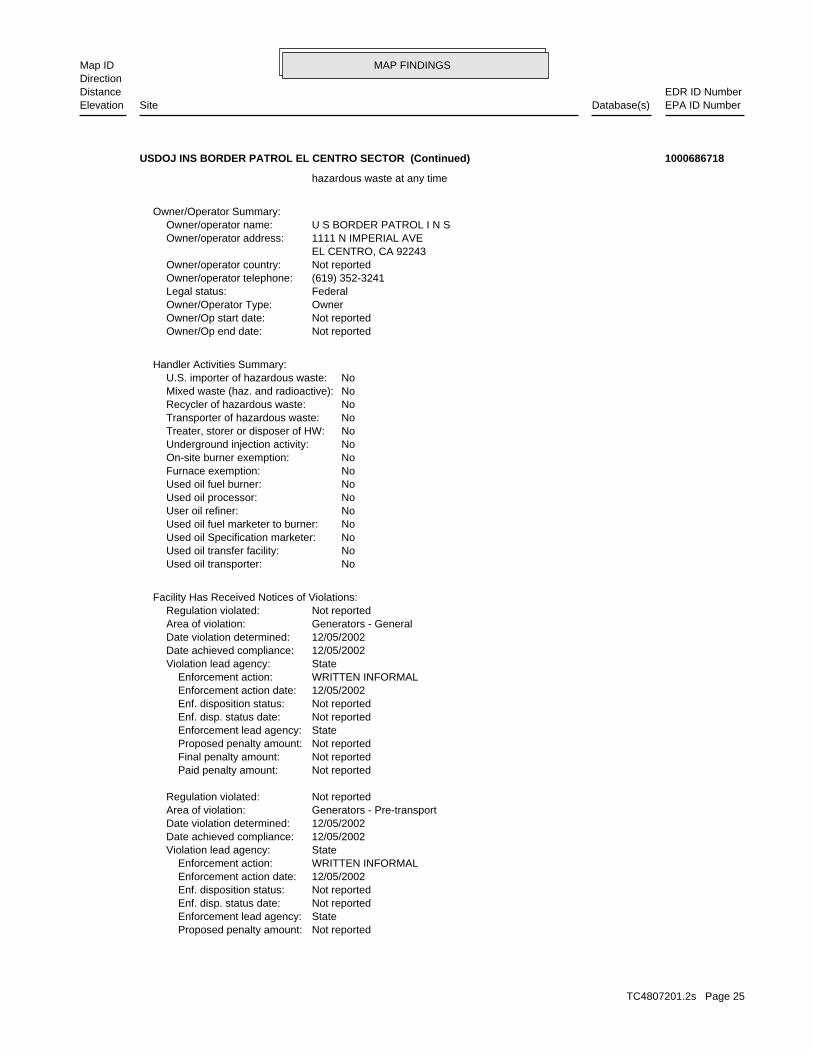
waste during any calendar month, and accumulates more than 1000 kg of hazardous waste at any time; or generates 100 kg or less of hazardous waste during any calendar month and accumulates less than 6000 kg of Handler: generates more than 100 and less than 1000 kg of hazardousDescription: Small Small Quantity GeneratorClassification: FederalLand type: 09EPA Region: Not reportedContact email: (619) 352-3241Contact telephone: USContact country: EL CENTRO, CA 92243 1111 N IMPERIAL AVEContact address: JOHNNY WILLIAMSContact: CA7151590604EPA ID: EL CENTRO, CA 92243 1111 N IMPERIAL AVEFacility address: USDOJ INS BORDER PATROL EL CENTRO SECTORFacility name: 02/13/1992Date form received by agency:
RCRA-SQG:
1005 ft. Site 4 of 7 in cluster E0.190 mi.
Relative:Higher
Actual:-40 ft.
1/8-1/4 ECHOEL CENTRO, CA 92243SSW FINDS1111 N IMPERIAL AVE CA7151590604E18 RCRA-SQGUSDOJ INS BORDER PATROL EL CENTRO SECTOR 1000686718
TC4807201.2s Page 24
MAP FINDINGSMap IDDirection
EDR ID NumberDistanceEPA ID NumberDatabase(s)SiteElevation
Not reported Proposed penalty amount: State Enforcement lead agency: Not reported Enf. disp. status date: Not reported Enf. disposition status: 12/05/2002 Enforcement action date: WRITTEN INFORMAL Enforcement action: StateViolation lead agency: 12/05/2002Date achieved compliance: 12/05/2002Date violation determined: Generators - Pre-transportArea of violation: Not reportedRegulation violated:
Not reported Paid penalty amount: Not reported Final penalty amount: Not reported Proposed penalty amount: State Enforcement lead agency: Not reported Enf. disp. status date: Not reported Enf. disposition status: 12/05/2002 Enforcement action date: WRITTEN INFORMAL Enforcement action: StateViolation lead agency: 12/05/2002Date achieved compliance: 12/05/2002Date violation determined: Generators - GeneralArea of violation: Not reportedRegulation violated:
Facility Has Received Notices of Violations:
NoUsed oil transporter: NoUsed oil transfer facility: NoUsed oil Specification marketer: NoUsed oil fuel marketer to burner: NoUser oil refiner: NoUsed oil processor: NoUsed oil fuel burner: NoFurnace exemption: NoOn-site burner exemption: NoUnderground injection activity: NoTreater, storer or disposer of HW: NoTransporter of hazardous waste: NoRecycler of hazardous waste: NoMixed waste (haz. and radioactive): NoU.S. importer of hazardous waste:
Handler Activities Summary:
Not reportedOwner/Op end date: Not reportedOwner/Op start date: OwnerOwner/Operator Type: FederalLegal status: (619) 352-3241Owner/operator telephone: Not reportedOwner/operator country: EL CENTRO, CA 92243 1111 N IMPERIAL AVEOwner/operator address: U S BORDER PATROL I N SOwner/operator name:
Owner/Operator Summary:
hazardous waste at any time
USDOJ INS BORDER PATROL EL CENTRO SECTOR (Continued) 1000686718
TC4807201.2s Page 25

MAP FINDINGSMap IDDirection
EDR ID NumberDistanceEPA ID NumberDatabase(s)SiteElevation
http://echo.epa.gov/detailed_facility_report?fid=110002625669DFR URL: 110002625669Registry ID: 1000686718Envid:
ECHO:
Incident Tracking, Compliance Assistance, and Compliance Monitoring.that support Compliance and Enforcement programs. These include;has the capability to track other activities occurring in the Regionthat information with Federal actions already in the system. ICIS alsoCompliance System (PCS) which supports the NPDES and will integrateit Headquarters. A future release of ICIS will replace the Permitinformation is maintained in ICIS by EPA in the Regional offices andFederal Administrative and Judicial enforcement actions. Thisa single repository for that information. Currently, ICIS contains allreplace EPA’s independent databases that contain Enforcement data withinformation across most of EPA’s programs. The vision for ICIS is tocomplete, will contain integrated Enforcement and ComplianceCompliance Information System and provides a database that, whenICIS (Integrated Compliance Information System) is the Integrated
STATE MASTER
corrective action activities required under RCRA.program staff to track the notification, permit, compliance, andand treat, store, or dispose of hazardous waste. RCRAInfo allows RCRAevents and activities related to facilities that generate, transport,Conservation and Recovery Act (RCRA) program through the tracking ofRCRAInfo is a national information system that supports the Resource Environmental Interest/Information System
110002625669Registry ID:
FINDS:
StateEvaluation lead agency: 12/05/2002Date achieved compliance: Generators - Pre-transportArea of violation: COMPLIANCE EVALUATION INSPECTION ON-SITEEvaluation: 12/05/2002Evaluation date:
StateEvaluation lead agency: 12/05/2002Date achieved compliance: Generators - GeneralArea of violation: COMPLIANCE EVALUATION INSPECTION ON-SITEEvaluation: 12/05/2002Evaluation date:
Evaluation Action Summary:
Not reported Paid penalty amount: Not reported Final penalty amount:
USDOJ INS BORDER PATROL EL CENTRO SECTOR (Continued) 1000686718
TC4807201.2s Page 26

MAP FINDINGSMap IDDirection
EDR ID NumberDistanceEPA ID NumberDatabase(s)SiteElevation
T0602500099Global Id:
04/30/1992Status Date: Open - Site AssessmentStatus: T0602500099Global Id:
04/27/1992Status Date: Open - Case Begin DateStatus: T0602500099Global Id:
05/14/2001Status Date: Completed - Case ClosedStatus: T0602500099Global Id:
Status History:
Not reportedPhone Number: Not reportedEmail: EL CENTROCity: 939 MAIN STRRETAddress: IMPERIAL COUNTYOrganization Name: JERRY STILWELLContact Name: Local Agency CaseworkerContact Type: T0602500099Global Id:
7607768986Phone Number: [email protected]: PALM DESERTCity: 73-720 FRED WARING DRIVE, SUIE 100Address: COLORADO RIVER BASIN RWQCB (REGION 7)Organization Name: KOLA OLATUNBOSUNContact Name: Regional Board CaseworkerContact Type: T0602500099Global Id:
Contact:
Click here to access the California GeoTracker records for this facility:
Not reportedSite History: Diesel, GasolinePotential Contaminants of Concern: Other Groundwater (uses other than drinking water)Potential Media Affect: Not reportedFile Location: Not reportedLOC Case Number: 7T2243049RB Case Number: IMPERIAL COUNTYLocal Agency: KOCase Worker: COLORADO RIVER BASIN RWQCB (REGION 7)Lead Agency: 05/14/2001Status Date: Completed - Case ClosedStatus: LUST Cleanup SiteCase Type: -115.5697339Longitude: 32.8016226Latitude: T0602500099Global Id: STATERegion:
LUST:
1005 ft. CUPA ListingsSite 5 of 7 in cluster E0.190 mi. CA FID UST
Relative:Higher
Actual:-40 ft.
1/8-1/4 HIST USTEL CENTRO, CA 92244SSW SWEEPS UST1111 N IMPERIAL AVE N/AE19 LUSTU.S.BORDER PATROL HEADQUARTERS S101619139
TC4807201.2s Page 27

MAP FINDINGSMap IDDirection
EDR ID NumberDistanceEPA ID NumberDatabase(s)SiteElevation
M.V. FUELTank Use: 07-27-90Active Date: 4000Capacity: ATank Status: 13-000-000532-000002SWRCB Tank Id: 2Owner Tank Id: 07-27-90Created Date: 02-04-93Action Date: 02-04-93Referral Date: Not reportedBoard Of Equalization: 7Number: 532Comp Number: ActiveStatus:
3Number Of Tanks: REG UNLEADEDContent: WSTG: M.V. FUELTank Use: 07-27-90Active Date: 1000Capacity: ATank Status: 13-000-000532-000001SWRCB Tank Id: 1Owner Tank Id: 07-27-90Created Date: 02-04-93Action Date: 02-04-93Referral Date: Not reportedBoard Of Equalization: 7Number: 532Comp Number: ActiveStatus:
SWEEPS UST:
Leak DiscoveryAction: 04/27/1992Date: OtherAction Type: T0602500099Global Id:
Leak ReportedAction: 04/30/1992Date: OtherAction Type: T0602500099Global Id:
Monitoring Report - OtherAction: 03/30/2001Date: RESPONSEAction Type: T0602500099Global Id:
Closure/No Further Action LetterAction: 05/14/2001Date: ENFORCEMENTAction Type: T0602500099Global Id:
Regulatory Activities:
06/22/1992Status Date: Open - Site AssessmentStatus:
U.S.BORDER PATROL HEADQUARTERS (Continued) S101619139
TC4807201.2s Page 28

MAP FINDINGSMap IDDirection
EDR ID NumberDistanceEPA ID NumberDatabase(s)SiteElevation
Not reportedMailing Address 2: P O BOXMailing Address: Not reportedMail To: 6193523241Facility Phone: Not reportedSIC Code: Not reportedCortese Code: Not reportedRegulated ID: UTNKARegulated By: 13000043Facility ID:
CA FID UST:
Click here for Geo Tracker PDF:
Not reportedLeak Detection: Not reportedContainer Construction Thickness: Not reportedType of Fuel: Not reportedTank Used for: Not reportedTank Capacity: Not reportedYear Installed: Not reportedContainer Num: Not reportedTank Num:
Not reportedTotal Tanks: Not reportedOwner City,St,Zip: Not reportedOwner Address: Not reportedOwner Name: Not reportedTelephone: Not reportedContact Name: Not reportedOther Type: Not reportedFacility Type: Not reportedFacility ID: Not reportedRegion: http://geotracker.waterboards.ca.gov/ustpdfs/pdf/00023ECE.pdfURL: 00023ECEFile Number:
HIST UST:
Not reportedNumber Of Tanks: REG UNLEADEDContent: PSTG: M.V. FUELTank Use: 07-27-90Active Date: 4000Capacity: ATank Status: 13-000-000532-000003SWRCB Tank Id: 3Owner Tank Id: 07-27-90Created Date: 02-04-93Action Date: 02-04-93Referral Date: Not reportedBoard Of Equalization: 7Number: 532Comp Number: ActiveStatus:
Not reportedNumber Of Tanks: REG UNLEADEDContent: PSTG:
U.S.BORDER PATROL HEADQUARTERS (Continued) S101619139
TC4807201.2s Page 29

MAP FINDINGSMap IDDirection
EDR ID NumberDistanceEPA ID NumberDatabase(s)SiteElevation
DEPT. OF HOMELAND SECURITYCare Of: PR0001586Record Id: 4452 - HAZ WASTE GENERATOR < 1TONProgram Element/Description: Not reportedSIC Code: ActiveFacility Status:
Detail As Of May 2012:
IMPERIALRegion:
Not reportedEmployee Id And Name: 760-352-3241Work/Business Phone: 760-352-8245Home Phone: IMPERIAL, IMPERIAL 92251Owner City/State/Zip: 211 W. ATEN ROADOwner Address2: 211 W ATEN RDOwner Address1: U.S. BORDER PATROLOwner Name: OW0000371New Owner Id: U.S. BORDER PATROLOwner Dba: U.S. BORDER PATROLCare Of 1: DEPT. OF HOMELAND SECURITYCare Of: PR0001586Record Id: 4452 - HAZ WASTE GENERATOR < 1TONProgram Element/Description: Not reportedSIC Code: ActiveFacility Status:
Detail As Of May 2012:
IMPERIALRegion:CUPA IMPERIAL:
ActiveStatus: Not reportedComments: Not reportedEPA ID: Not reportedNPDES Number: Not reportedDUNs Number: Not reportedContact Phone: Not reportedContact: EL CENTRO 92244Mailing City,St,Zip:
U.S.BORDER PATROL HEADQUARTERS (Continued) S101619139
TC4807201.2s Page 30

MAP FINDINGSMap IDDirection
EDR ID NumberDistanceEPA ID NumberDatabase(s)SiteElevation
Not reportedEmployee Id And Name: 760-352-3241Work/Business Phone: 760-352-8245Home Phone: IMPERIAL, IMPERIAL 92251Owner City/State/Zip: 211 W. ATEN ROADOwner Address2: 211 W ATEN RDOwner Address1: U.S. BORDER PATROLOwner Name: OW0000371New Owner Id: U.S. BORDER PATROLOwner Dba: U.S. BORDER PATROLCare Of 1:
U.S.BORDER PATROL HEADQUARTERS (Continued) S101619139
Not reportedEPAID: Not reportedProperty Owner Country: Not reportedProperty Owner Zip Code: Not reportedProperty Owner Stat : Not reportedProperty Owner City: Not reportedProperty Owner Mailing Address: Not reportedProperty Owner Phone: Not reportedProperty Owner Name: Not reportedOwner Country: Not reportedOwner Zip Code: Not reportedOwner State: Not reportedOwner Mail Address: Not reportedOwner Phone: Not reportedOperator Phone: Not reportedOperator Name: Not reportedMailing Address Zip Code: Not reportedMailing Address State: Not reportedMailing Address City: Not reportedMailing Address: Not reportedFax: Not reportedPhone: Not reportedBusiness Name: Not reportedFacility ID: Not reportedCERSID: 10,000Total Gallons: US BORDER PATROLOwner: ImperialCertified Unified Program Agencies:
AST:
1005 ft. Site 6 of 7 in cluster E0.190 mi.
Relative:Higher
Actual:-40 ft.
1/8-1/4 EL CENTRO, CA SSW 1111 N. IMPERIAL AVE. N/AE20 ASTUS BORDER PATROL-EL CENTRO A100325413
TC4807201.2s Page 31

MAP FINDINGSMap IDDirection
EDR ID NumberDistanceEPA ID NumberDatabase(s)SiteElevation
-115.56972Longitude: 32.8027Latitude: IMPERIAL COUNTYPermitting Agency: 997Facility ID:
UST:
1005 ft. Site 7 of 7 in cluster E0.190 mi.
Relative:Higher
Actual:-40 ft.
1/8-1/4 EL CENTRO, CA 92243SSW 1111 N IMPERIAL AVE N/AE21 USTUS BORDER PATROL SECTOR HQ U004050960
05/30/2013Owner/Op start date: OperatorOwner/Operator Type: PrivateLegal status: Not reportedOwner/operator telephone: USOwner/operator country: Not reported Not reportedOwner/operator address: HARBOR FREIGHT TOOLS USA INCOwner/operator name:
Not reportedOwner/Op end date: 01/01/2007Owner/Op start date: OwnerOwner/Operator Type: PrivateLegal status: 213-927-2700Owner/operator telephone: USOwner/operator country: LOS ANGELES, 90015 1300 W OLYMPIC BLVD STE 500Owner/operator address: EL CENTRO COLLECTION ONE THROUGH NINEOwner/operator name:
Owner/Operator Summary:
hazardous waste at any time waste during any calendar month, and accumulates more than 1000 kg of hazardous waste at any time; or generates 100 kg or less of hazardous waste during any calendar month and accumulates less than 6000 kg of Handler: generates more than 100 and less than 1000 kg of hazardousDescription: Small Small Quantity GeneratorClassification: 09EPA Region: [email protected] email: 818-836-5137Contact telephone: USContact country: CALABASAS, CA 91302 26541 AGOURA RDContact address: MIKE WALLACEContact: CALABASAS, CA 91302 26541 AGOURA RDMailing address: CAR000246199EPA ID: EL CENTRO, CA 92243 1750 N IMPERIAL AVEFacility address: HARBOR FREIGHT TOOLS USA INCFacility name: 04/29/2014Date form received by agency:
RCRA-SQG:
1059 ft. Site 1 of 2 in cluster F0.201 mi.
Relative:Lower
Actual:-45 ft.
1/8-1/4 ECHOEL CENTRO, CA 92243NW FINDS1750 N IMPERIAL AVE CAR000246199F22 RCRA-SQGHARBOR FREIGHT TOOLS USA INC 1016674980
TC4807201.2s Page 32

MAP FINDINGSMap IDDirection
EDR ID NumberDistanceEPA ID NumberDatabase(s)SiteElevation
CHROMIUM. Waste name: D007. Waste code:
CADMIUM. Waste name: D006. Waste code:
IGNITABLE WASTE. Waste name: D001. Waste code:
561. Waste name: 561. Waste code:
352. Waste name: 352. Waste code:
343. Waste name: 343. Waste code:
291. Waste name: 291. Waste code:
281. Waste name: 281. Waste code:
272. Waste name: 272. Waste code:
271. Waste name: 271. Waste code:
181. Waste name: 181. Waste code:
135. Waste name: 135. Waste code:
121. Waste name: 121. Waste code:
NoUsed oil transporter: NoUsed oil transfer facility: NoUsed oil Specification marketer: NoUsed oil fuel marketer to burner: NoUser oil refiner: NoUsed oil processor: NoUsed oil fuel burner: NoFurnace exemption: NoOn-site burner exemption: NoUnderground injection activity: NoTreater, storer or disposer of HW: NoTransporter of hazardous waste: NoRecycler of hazardous waste: NoMixed waste (haz. and radioactive): NoU.S. importer of hazardous waste:
Handler Activities Summary:
Not reportedOwner/Op end date:
HARBOR FREIGHT TOOLS USA INC (Continued) 1016674980
TC4807201.2s Page 33

MAP FINDINGSMap IDDirection
EDR ID NumberDistanceEPA ID NumberDatabase(s)SiteElevation
http://echo.epa.gov/detailed_facility_report?fid=110059766579DFR URL: 110059766579Registry ID: 1016674980Envid:
ECHO:
STATE MASTER
corrective action activities required under RCRA.program staff to track the notification, permit, compliance, andand treat, store, or dispose of hazardous waste. RCRAInfo allows RCRAevents and activities related to facilities that generate, transport,Conservation and Recovery Act (RCRA) program through the tracking ofRCRAInfo is a national information system that supports the Resource Environmental Interest/Information System
110059766579Registry ID:
FINDS:
No violations foundViolation Status:
MERCURY. Waste name: D009. Waste code:
LEAD. Waste name: D008. Waste code:
HARBOR FREIGHT TOOLS USA INC (Continued) 1016674980
IMPERIALRegion:CUPA IMPERIAL:
1059 ft. Site 2 of 2 in cluster F0.201 mi.
Relative:Lower
Actual:-45 ft.
1/8-1/4 EL CENTRO, CA 92243NW 1750 N IMPERIAL AVE N/AF23 CUPA ListingsHARBOR FREIGHT TOOL USA, INC. S117332695
3333 BEVERLY RD B5 362AOwner Address1: KMART CORPORATIONOwner Name: OW0000704New Owner Id: Not reportedOwner Dba: CHRIS LIPMANCare Of 1: KMART CORPORATIONCare Of: PR0002564Record Id: 4452 - HAZ WASTE GENERATOR < 1TONProgram Element/Description: 5399SIC Code: ActiveFacility Status:
Detail As Of May 2012:
IMPERIALRegion:CUPA IMPERIAL:
1073 ft.0.203 mi.
Relative:Lower
Actual:-45 ft.
1/8-1/4 EL CENTRO, CA 92243NNW 1950 N IMPERIAL AVE N/A24 CUPA ListingsKMART #3151 S109934612
TC4807201.2s Page 34

MAP FINDINGSMap IDDirection
EDR ID NumberDistanceEPA ID NumberDatabase(s)SiteElevation
Not reportedEmployee Id And Name: 847-286-7222Work/Business Phone: 847-286-7222Home Phone: HOFFMAN ESTATES, HOFFMAN ESTATES 60179Owner City/State/Zip: 3333 BEVERLY ROADOwner Address2:
KMART #3151 (Continued) S109934612
T0602500071Global Id:
08/24/1992Status Date: Completed - Case ClosedStatus: T0602500071Global Id:
Status History:
Not reportedPhone Number: Not reportedEmail: EL CENTROCity: 939 MAIN STRRETAddress: IMPERIAL COUNTYOrganization Name: JERRY STILWELLContact Name: Local Agency CaseworkerContact Type: T0602500071Global Id:
7607768986Phone Number: [email protected]: PALM DESERTCity: 73-720 FRED WARING DRIVE, SUIE 100Address: COLORADO RIVER BASIN RWQCB (REGION 7)Organization Name: KOLA OLATUNBOSUNContact Name: Regional Board CaseworkerContact Type: T0602500071Global Id:
Contact:
Click here to access the California GeoTracker records for this facility:
Not reportedSite History: DieselPotential Contaminants of Concern: SoilPotential Media Affect: Not reportedFile Location: Not reportedLOC Case Number: 7T2243016RB Case Number: IMPERIAL COUNTYLocal Agency: KOCase Worker: COLORADO RIVER BASIN RWQCB (REGION 7)Lead Agency: 08/24/1992Status Date: Completed - Case ClosedStatus: LUST Cleanup SiteCase Type: -115.5733792Longitude: 32.8056392Latitude: T0602500071Global Id: STATERegion:
LUST:
1499 ft. Site 1 of 2 in cluster G0.284 mi.
Relative:Higher
Actual:-42 ft.
1/4-1/2 EL CENTRO, CA 92243WSW 1675 WEST PICO AVENUE N/AG25 LUSTEL CENTRO MAIN SEWER LIST STA S102429151
TC4807201.2s Page 35

MAP FINDINGSMap IDDirection
EDR ID NumberDistanceEPA ID NumberDatabase(s)SiteElevation
GSCase Worker:Regional BoardLead Agency:T0602500071Global ID:722ID:Diesel fuel oil and additivesSubstance:7T2243016Case Num:9 - Case ClosedStatus:7Region:
LUST REG 7:
Leak DiscoveryAction: 09/29/1986Date: OtherAction Type: T0602500071Global Id:
Leak ReportedAction: 05/22/1989Date: OtherAction Type: T0602500071Global Id:
Leak StoppedAction: 01/20/1987Date: OtherAction Type: T0602500071Global Id:
Regulatory Activities:
09/29/1986Status Date: Open - Case Begin DateStatus:
EL CENTRO MAIN SEWER LIST STA (Continued) S102429151
7T2243016Reg Id: LTNKAReg By: 13Facility County Code: CORTESERegion:
HIST CORTESE:
1499 ft. Site 2 of 2 in cluster G0.284 mi.
Relative:Higher
Actual:-42 ft.
1/4-1/2 EL CENTRO, CA 92243WSW 1675 PICO N/AG26 HIST CORTESEEL CENTRO MAIN SEWER LIST S105023600
Open - Site AssessmentStatus: LUST Cleanup SiteCase Type: -115.570507049561Longitude: 32.8011275411169Latitude: T0602562350Global Id: STATERegion:
LUST:
1748 ft.0.331 mi.
Relative:Higher
Actual:-40 ft.
1/4-1/2 EL CENTRO, CA 92243SSW PRIVATE RESIDENCE N/A27 LUSTPRIVATE RESIDENCE S110654218
TC4807201.2s Page 36

MAP FINDINGSMap IDDirection
EDR ID NumberDistanceEPA ID NumberDatabase(s)SiteElevation
Open - Site AssessmentStatus: T0602562350Global Id:
11/14/2003Status Date: Open - Site AssessmentStatus: T0602562350Global Id:
07/11/2003Status Date: Open - Site AssessmentStatus: T0602562350Global Id:
03/31/2003Status Date: Open - Site AssessmentStatus: T0602562350Global Id:
01/03/2003Status Date: Open - Site AssessmentStatus: T0602562350Global Id:
10/16/2003Status Date: Open - RemediationStatus: T0602562350Global Id:
01/03/2003Status Date: Open - Case Begin DateStatus: T0602562350Global Id:
Status History:
7607768986Phone Number: [email protected]: PALM DESERTCity: 73-720 FRED WARING DRIVE, SUIE 100Address: COLORADO RIVER BASIN RWQCB (REGION 7)Organization Name: KOLA OLATUNBOSUNContact Name: Regional Board CaseworkerContact Type: T0602562350Global Id:
Contact:
Click here to access the California GeoTracker records for this facility:
dispenser islands. unleaded gasoline USTs, one 12,000-gallon diesel UST, and three fuel currently a retail gasoline service station with three 12,000-gallon monitoring is the only action on the site at this time. The site is removed from the site and no remediation has been done. Groundwater soil and groundwater were minimally affected. Nothing has been investigation and testing done in December 2002 revealed that both A discharge of unknown substance was found in the soil during a siteSite History: GasolinePotential Contaminants of Concern: Other Groundwater (uses other than drinking water)Potential Media Affect: Regional BoardFile Location: Not reportedLOC Case Number: 7T2243042RB Case Number: Not reportedLocal Agency: KOCase Worker: COLORADO RIVER BASIN RWQCB (REGION 7)Lead Agency: 04/01/2014Status Date:
PRIVATE RESIDENCE (Continued) S110654218
TC4807201.2s Page 37
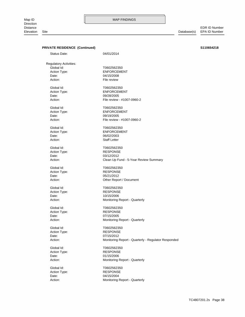
MAP FINDINGSMap IDDirection
EDR ID NumberDistanceEPA ID NumberDatabase(s)SiteElevation
Monitoring Report - QuarterlyAction: 04/15/2004Date: RESPONSEAction Type: T0602562350Global Id:
Monitoring Report - QuarterlyAction: 01/15/2006Date: RESPONSEAction Type: T0602562350Global Id:
Monitoring Report - Quarterly - Regulator RespondedAction: 07/15/2012Date: RESPONSEAction Type: T0602562350Global Id:
Monitoring Report - QuarterlyAction: 07/15/2005Date: RESPONSEAction Type: T0602562350Global Id:
Monitoring Report - QuarterlyAction: 10/15/2006Date: RESPONSEAction Type: T0602562350Global Id:
Other Report / DocumentAction: 05/21/2012Date: RESPONSEAction Type: T0602562350Global Id:
Clean Up Fund - 5-Year Review SummaryAction: 03/12/2012Date: RESPONSEAction Type: T0602562350Global Id:
Staff LetterAction: 06/02/2003Date: ENFORCEMENTAction Type: T0602562350Global Id:
File review - #1007-0960-2Action: 09/19/2005Date: ENFORCEMENTAction Type: T0602562350Global Id:
File review - #1007-0960-2Action: 09/28/2005Date: ENFORCEMENTAction Type: T0602562350Global Id:
File reviewAction: 04/15/2008Date: ENFORCEMENTAction Type: T0602562350Global Id:
Regulatory Activities:
04/01/2014Status Date:
PRIVATE RESIDENCE (Continued) S110654218
TC4807201.2s Page 38

MAP FINDINGSMap IDDirection
EDR ID NumberDistanceEPA ID NumberDatabase(s)SiteElevation
RESPONSEAction Type: T0602562350Global Id:
Other Report / Document - Regulator RespondedAction: 06/09/2016Date: RESPONSEAction Type: T0602562350Global Id:
Request for Closure - Regulator RespondedAction: 05/19/2016Date: RESPONSEAction Type: T0602562350Global Id:
Request for Closure - Regulator RespondedAction: 01/29/2016Date: RESPONSEAction Type: T0602562350Global Id:
Request for Closure - Regulator RespondedAction: 03/19/2016Date: RESPONSEAction Type: T0602562350Global Id:
Interim Remedial Action Report - Regulator RespondedAction: 11/13/2015Date: RESPONSEAction Type: T0602562350Global Id:
Monitoring Report - QuarterlyAction: 01/15/2007Date: RESPONSEAction Type: T0602562350Global Id:
Monitoring Report - QuarterlyAction: 10/15/2005Date: RESPONSEAction Type: T0602562350Global Id:
Monitoring Report - QuarterlyAction: 07/15/2006Date: RESPONSEAction Type: T0602562350Global Id:
Monitoring Report - QuarterlyAction: 04/15/2006Date: RESPONSEAction Type: T0602562350Global Id:
Well Destruction Workplan - Regulator RespondedAction: 11/14/2013Date: RESPONSEAction Type: T0602562350Global Id:
Monitoring Report - QuarterlyAction: 04/15/2005Date: RESPONSEAction Type: T0602562350Global Id:
PRIVATE RESIDENCE (Continued) S110654218
TC4807201.2s Page 39

MAP FINDINGSMap IDDirection
EDR ID NumberDistanceEPA ID NumberDatabase(s)SiteElevation
Monitoring Report - QuarterlyAction: 10/15/2008Date: RESPONSEAction Type: T0602562350Global Id:
Leak StoppedAction: 01/03/2003Date: OtherAction Type: T0602562350Global Id:
13267 Monitoring Program - #10070960-2Action: 07/15/2004Date: ENFORCEMENTAction Type: T0602562350Global Id:
Other Report / DocumentAction: 01/15/2008Date: RESPONSEAction Type: T0602562350Global Id:
Other ReportAction: 08/02/2016Date: ENFORCEMENTAction Type: T0602562350Global Id:
Soil and Water Investigation ReportAction: 04/15/2003Date: RESPONSEAction Type: T0602562350Global Id:
File reviewAction: 09/28/2007Date: ENFORCEMENTAction Type: T0602562350Global Id:
Monitoring Report - QuarterlyAction: 07/15/2007Date: RESPONSEAction Type: T0602562350Global Id:
Request for ClosureAction: 10/15/2007Date: RESPONSEAction Type: T0602562350Global Id:
Monitoring Report - QuarterlyAction: 10/15/2007Date: RESPONSEAction Type: T0602562350Global Id:
Other Report / DocumentAction: 04/15/2008Date: RESPONSEAction Type: T0602562350Global Id:
Monitoring Report - QuarterlyAction: 04/15/2007Date:
PRIVATE RESIDENCE (Continued) S110654218
TC4807201.2s Page 40

MAP FINDINGSMap IDDirection
EDR ID NumberDistanceEPA ID NumberDatabase(s)SiteElevation
ENFORCEMENTAction Type: T0602562350Global Id:
File reviewAction: 05/24/2006Date: ENFORCEMENTAction Type: T0602562350Global Id:
File reviewAction: 01/25/2007Date: ENFORCEMENTAction Type: T0602562350Global Id:
Other Report / DocumentAction: 08/14/2008Date: RESPONSEAction Type: T0602562350Global Id:
Notification - Public Notice of Case ClosureAction: 06/02/2016Date: ENFORCEMENTAction Type: T0602562350Global Id:
Notification - Public Notice of Case ClosureAction: 05/09/2016Date: ENFORCEMENTAction Type: T0602562350Global Id:
File reviewAction: 04/18/2007Date: ENFORCEMENTAction Type: T0602562350Global Id:
File reviewAction: 02/02/2006Date: ENFORCEMENTAction Type: T0602562350Global Id:
File reviewAction: 10/16/2007Date: ENFORCEMENTAction Type: T0602562350Global Id:
File reviewAction: 12/23/2005Date: ENFORCEMENTAction Type: T0602562350Global Id:
File reviewAction: 01/17/2008Date: ENFORCEMENTAction Type: T0602562350Global Id:
Staff LetterAction: 07/23/2003Date: ENFORCEMENTAction Type: T0602562350Global Id:
PRIVATE RESIDENCE (Continued) S110654218
TC4807201.2s Page 41

MAP FINDINGSMap IDDirection
EDR ID NumberDistanceEPA ID NumberDatabase(s)SiteElevation
File reviewAction: 08/09/2006Date: ENFORCEMENTAction Type: T0602562350Global Id:
Staff Letter - #1007-0960-2Action: 04/21/2005Date: ENFORCEMENTAction Type: T0602562350Global Id:
File review - #1007-0960-2Action: 06/24/2005Date: ENFORCEMENTAction Type: T0602562350Global Id:
File reviewAction: 01/17/2007Date: ENFORCEMENTAction Type: T0602562350Global Id:
File review - #1007-0960-2Action: 04/01/2005Date: ENFORCEMENTAction Type: T0602562350Global Id:
Leak ReportedAction: 01/03/2003Date: OtherAction Type: T0602562350Global Id:
Monitoring Report - QuarterlyAction: 01/15/2013Date: RESPONSEAction Type: T0602562350Global Id:
* Historical EnforcementAction: 06/19/2003Date: ENFORCEMENTAction Type: T0602562350Global Id:
Staff LetterAction: 09/15/2003Date: ENFORCEMENTAction Type: T0602562350Global Id:
File review - #10070960-2Action: 07/15/2004Date: ENFORCEMENTAction Type: T0602562350Global Id:
Monitoring Report - QuarterlyAction: 01/15/2009Date: RESPONSEAction Type: T0602562350Global Id:
Staff LetterAction: 07/29/2015Date:
PRIVATE RESIDENCE (Continued) S110654218
TC4807201.2s Page 42

MAP FINDINGSMap IDDirection
EDR ID NumberDistanceEPA ID NumberDatabase(s)SiteElevation
ENFORCEMENTAction Type: T0602562350Global Id:
Monitoring Report - QuarterlyAction: 04/15/2009Date: RESPONSEAction Type: T0602562350Global Id:
Other Report / DocumentAction: 12/27/2011Date: RESPONSEAction Type: T0602562350Global Id:
Staff LetterAction: 07/29/2009Date: ENFORCEMENTAction Type: T0602562350Global Id:
File reviewAction: 01/15/2008Date: ENFORCEMENTAction Type: T0602562350Global Id:
Monitoring Report - Semi-AnnuallyAction: 02/07/2013Date: RESPONSEAction Type: T0602562350Global Id:
Leak DiscoveryAction: 01/03/2003Date: OtherAction Type: T0602562350Global Id:
File reviewAction: 02/09/2004Date: ENFORCEMENTAction Type: T0602562350Global Id:
File reviewAction: 11/06/2003Date: ENFORCEMENTAction Type: T0602562350Global Id:
Staff LetterAction: 02/27/2003Date: ENFORCEMENTAction Type: T0602562350Global Id:
File reviewAction: 12/12/2003Date: ENFORCEMENTAction Type: T0602562350Global Id:
Staff LetterAction: 04/14/2003Date: ENFORCEMENTAction Type: T0602562350Global Id:
PRIVATE RESIDENCE (Continued) S110654218
TC4807201.2s Page 43

MAP FINDINGSMap IDDirection
EDR ID NumberDistanceEPA ID NumberDatabase(s)SiteElevation
Soil and Water Investigation ReportAction: 11/17/2003Date: RESPONSEAction Type: T0602562350Global Id:
Remedial Progress ReportAction: 07/15/2003Date: RESPONSEAction Type: T0602562350Global Id:
Monitoring Report - QuarterlyAction: 04/15/2003Date: RESPONSEAction Type: T0602562350Global Id:
Monitoring Report - QuarterlyAction: 10/15/2003Date: RESPONSEAction Type: T0602562350Global Id:
Other WorkplanAction: 09/03/2003Date: RESPONSEAction Type: T0602562350Global Id:
Remedial Progress ReportAction: 10/15/2003Date: RESPONSEAction Type: T0602562350Global Id:
Preliminary Site Assessment ReportAction: 07/15/2003Date: RESPONSEAction Type: T0602562350Global Id:
Other Report / DocumentAction: 01/30/2003Date: RESPONSEAction Type: T0602562350Global Id:
Preliminary Site Assessment WorkplanAction: 03/31/2003Date: RESPONSEAction Type: T0602562350Global Id:
Preliminary Site Assessment ReportAction: 07/15/2003Date: RESPONSEAction Type: T0602562350Global Id:
Staff LetterAction: 12/03/2003Date: ENFORCEMENTAction Type: T0602562350Global Id:
Staff LetterAction: 04/25/2003Date:
PRIVATE RESIDENCE (Continued) S110654218
TC4807201.2s Page 44

MAP FINDINGSMap IDDirection
EDR ID NumberDistanceEPA ID NumberDatabase(s)SiteElevation
Monitoring Report - QuarterlyAction: 03/30/2005Date: RESPONSEAction Type: T0602562350Global Id:
Monitoring Report - QuarterlyAction: 03/11/2005Date: RESPONSEAction Type: T0602562350Global Id:
Monitoring Report - QuarterlyAction: 10/15/2004Date: RESPONSEAction Type: T0602562350Global Id:
Monitoring Report - QuarterlyAction: 01/15/2004Date: RESPONSEAction Type: T0602562350Global Id:
Monitoring Report - QuarterlyAction: 01/15/2005Date: RESPONSEAction Type: T0602562350Global Id:
PRIVATE RESIDENCE (Continued) S110654218
Not reportedPublic Information Officer: Not reportedPublic Information Officer: 40Senate District: 56Assembly District: Not reportedSite Code: Not reportedSupervisor: Not reportedTeam: Not reportedFacility Size: Historical - Non-OperatingFacility Type: -115.5699Longitude: 32.79914Latitude: KNOWN GENERATORSCleanup Status: CAL000091813EPA Id:
HWP:
2236 ft. Site 1 of 2 in cluster H0.423 mi.
Relative:Higher
Actual:-40 ft.
1/4-1/2 EL CENTRO, CA 92243South 805 NORTH IMPERIAL AVE N/AH28 HWPEL CENTRO TEXACO S109467303
TC4807201.2s Page 45

MAP FINDINGSMap IDDirection
EDR ID NumberDistanceEPA ID NumberDatabase(s)SiteElevation
T0602500101Global Id:
06/29/1998Status Date: Open - RemediationStatus: T0602500101Global Id:
10/30/1992Status Date: Open - Case Begin DateStatus: T0602500101Global Id:
Status History:
Not reportedPhone Number: Not reportedEmail: EL CENTROCity: 939 MAIN STRRETAddress: IMPERIAL COUNTYOrganization Name: JERRY STILWELLContact Name: Local Agency CaseworkerContact Type: T0602500101Global Id:
7607768986Phone Number: [email protected]: PALM DESERTCity: 73-720 FRED WARING DRIVE, SUIE 100Address: COLORADO RIVER BASIN RWQCB (REGION 7)Organization Name: KOLA OLATUNBOSUNContact Name: Regional Board CaseworkerContact Type: T0602500101Global Id:
Contact:
Click here to access the California GeoTracker records for this facility:
product and 397 gallons of free product has been removed. in Soil Vapor has been extracted, 41,650 gallons of groundwater/free product is currently present in MW-10/. Since 2008; 6,400 lbs of TPHg contamination. There are 12 monitoring wells at the site; free 1992 an environmental investigation led to the discovery of soilSite History: GasolinePotential Contaminants of Concern: Other Groundwater (uses other than drinking water)Potential Media Affect: Regional BoardFile Location: Not reportedLOC Case Number: 7T2243051RB Case Number: IMPERIAL COUNTYLocal Agency: KOCase Worker: COLORADO RIVER BASIN RWQCB (REGION 7)Lead Agency: 04/01/2014Status Date: Open - RemediationStatus: LUST Cleanup SiteCase Type: -115.569739937782Longitude: 32.7993599589111Latitude: T0602500101Global Id: STATERegion:
LUST:
2236 ft. Site 2 of 2 in cluster H0.423 mi.
Relative:Higher
Actual:-40 ft.
1/4-1/2 EL CENTRO, CA 92243South CUPA Listings805 N IMPERIAL AVE N/AH29 LUSTR & M PETROLEUM U001573921
TC4807201.2s Page 46

MAP FINDINGSMap IDDirection
EDR ID NumberDistanceEPA ID NumberDatabase(s)SiteElevation
Monitoring Report - QuarterlyAction: 07/15/2004Date: RESPONSEAction Type: T0602500101Global Id:
Monitoring Report - QuarterlyAction: 04/15/2006Date: RESPONSEAction Type: T0602500101Global Id:
Clean Up Fund - 5-Year Review SummaryAction: 03/12/2012Date: RESPONSEAction Type: T0602500101Global Id:
13267 Monitoring ProgramAction: 08/10/2005Date: ENFORCEMENTAction Type: T0602500101Global Id:
File reviewAction: 08/10/2005Date: ENFORCEMENTAction Type: T0602500101Global Id:
File reviewAction: 05/17/2007Date: ENFORCEMENTAction Type: T0602500101Global Id:
Regulatory Activities:
07/15/2009Status Date: Open - Site AssessmentStatus: T0602500101Global Id:
08/28/1998Status Date: Open - Site AssessmentStatus: T0602500101Global Id:
11/12/1992Status Date: Open - Site AssessmentStatus: T0602500101Global Id:
04/01/2014Status Date: Open - RemediationStatus: T0602500101Global Id:
07/05/2012Status Date: Open - RemediationStatus: T0602500101Global Id:
05/15/2006Status Date: Open - RemediationStatus: T0602500101Global Id:
07/08/1998Status Date: Open - RemediationStatus:
R & M PETROLEUM (Continued) U001573921
TC4807201.2s Page 47

MAP FINDINGSMap IDDirection
EDR ID NumberDistanceEPA ID NumberDatabase(s)SiteElevation
ENFORCEMENTAction Type: T0602500101Global Id:
Monitoring Report - QuarterlyAction: 01/15/2008Date: RESPONSEAction Type: T0602500101Global Id:
Free Product RemovalAction: 07/08/1998Date: REMEDIATIONAction Type: T0602500101Global Id:
Monitoring Report - QuarterlyAction: 01/15/2007Date: RESPONSEAction Type: T0602500101Global Id:
Monitoring Report - QuarterlyAction: 04/15/2007Date: RESPONSEAction Type: T0602500101Global Id:
Monitoring Report - QuarterlyAction: 07/15/2007Date: RESPONSEAction Type: T0602500101Global Id:
Removal Action Work Plan - Regulator RespondedAction: 03/29/2015Date: RESPONSEAction Type: T0602500101Global Id:
Monitoring Report - QuarterlyAction: 10/15/2006Date: RESPONSEAction Type: T0602500101Global Id:
Remedial Progress ReportAction: 07/15/2006Date: RESPONSEAction Type: T0602500101Global Id:
Monitoring Report - QuarterlyAction: 10/15/2005Date: RESPONSEAction Type: T0602500101Global Id:
Monitoring Report - QuarterlyAction: 01/15/2005Date: RESPONSEAction Type: T0602500101Global Id:
Monitoring Report - QuarterlyAction: 10/15/2004Date: RESPONSEAction Type: T0602500101Global Id:
R & M PETROLEUM (Continued) U001573921
TC4807201.2s Page 48

MAP FINDINGSMap IDDirection
EDR ID NumberDistanceEPA ID NumberDatabase(s)SiteElevation
Staff LetterAction: 07/29/2009Date: ENFORCEMENTAction Type: T0602500101Global Id:
Clean Up Fund - Letter to RPAction: 03/17/2016Date: ENFORCEMENTAction Type: T0602500101Global Id:
Monitoring Report - Semi-AnnuallyAction: 10/15/2010Date: RESPONSEAction Type: T0602500101Global Id:
Free Product RemovalAction: 06/16/1998Date: REMEDIATIONAction Type: T0602500101Global Id:
File reviewAction: 04/16/2008Date: ENFORCEMENTAction Type: T0602500101Global Id:
13267 Monitoring Program - #00000000Action: 08/10/2005Date: ENFORCEMENTAction Type: T0602500101Global Id:
File reviewAction: 12/22/2005Date: ENFORCEMENTAction Type: T0602500101Global Id:
Other Report / DocumentAction: 05/28/2008Date: RESPONSEAction Type: T0602500101Global Id:
Monitoring Report - QuarterlyAction: 04/15/2008Date: RESPONSEAction Type: T0602500101Global Id:
File reviewAction: 02/01/2008Date: ENFORCEMENTAction Type: T0602500101Global Id:
File reviewAction: 07/28/2003Date: ENFORCEMENTAction Type: T0602500101Global Id:
Staff LetterAction: 05/26/2005Date:
R & M PETROLEUM (Continued) U001573921
TC4807201.2s Page 49

MAP FINDINGSMap IDDirection
EDR ID NumberDistanceEPA ID NumberDatabase(s)SiteElevation
RESPONSEAction Type: T0602500101Global Id:
Soil Vapor Extraction (SVE)Action: 05/12/2008Date: REMEDIATIONAction Type: T0602500101Global Id:
Soil Vapor Extraction (SVE)Action: 05/12/2008Date: REMEDIATIONAction Type: T0602500101Global Id:
File reviewAction: 03/03/2006Date: ENFORCEMENTAction Type: T0602500101Global Id:
File reviewAction: 04/11/2007Date: ENFORCEMENTAction Type: T0602500101Global Id:
File reviewAction: 04/10/2007Date: ENFORCEMENTAction Type: T0602500101Global Id:
File reviewAction: 01/18/2008Date: ENFORCEMENTAction Type: T0602500101Global Id:
File reviewAction: 11/16/2007Date: ENFORCEMENTAction Type: T0602500101Global Id:
Monitoring Report - QuarterlyAction: 10/15/2008Date: RESPONSEAction Type: T0602500101Global Id:
Soil and Water Investigation ReportAction: 01/13/2011Date: RESPONSEAction Type: T0602500101Global Id:
File reviewAction: 04/14/2006Date: ENFORCEMENTAction Type: T0602500101Global Id:
Staff LetterAction: 07/29/2009Date: ENFORCEMENTAction Type: T0602500101Global Id:
R & M PETROLEUM (Continued) U001573921
TC4807201.2s Page 50

MAP FINDINGSMap IDDirection
EDR ID NumberDistanceEPA ID NumberDatabase(s)SiteElevation
Leak ReportedAction: 11/12/1992Date: OtherAction Type: T0602500101Global Id:
Remedial Progress ReportAction: 04/15/2013Date: RESPONSEAction Type: T0602500101Global Id:
Staff LetterAction: 10/27/2010Date: ENFORCEMENTAction Type: T0602500101Global Id:
Monitoring Report - QuarterlyAction: 09/15/2008Date: RESPONSEAction Type: T0602500101Global Id:
Monitoring Report - QuarterlyAction: 04/15/2011Date: RESPONSEAction Type: T0602500101Global Id:
File reviewAction: 05/28/2008Date: ENFORCEMENTAction Type: T0602500101Global Id:
File reviewAction: 10/12/2007Date: ENFORCEMENTAction Type: T0602500101Global Id:
Other WorkplanAction: 03/15/2015Date: RESPONSEAction Type: T0602500101Global Id:
Other Report / DocumentAction: 04/15/2011Date: RESPONSEAction Type: T0602500101Global Id:
Monitoring Report - Semi-AnnuallyAction: 01/15/2010Date: RESPONSEAction Type: T0602500101Global Id:
Monitoring Report - QuarterlyAction: 01/15/2005Date: RESPONSEAction Type: T0602500101Global Id:
Other Report / DocumentAction: 04/16/2008Date:
R & M PETROLEUM (Continued) U001573921
TC4807201.2s Page 51

MAP FINDINGSMap IDDirection
EDR ID NumberDistanceEPA ID NumberDatabase(s)SiteElevation
RESPONSEAction Type: T0602500101Global Id:
Monitoring Report - QuarterlyAction: 01/15/2003Date: RESPONSEAction Type: T0602500101Global Id:
Monitoring Report - QuarterlyAction: 07/15/2003Date: RESPONSEAction Type: T0602500101Global Id:
File reviewAction: 09/21/2006Date: ENFORCEMENTAction Type: T0602500101Global Id:
Other Report / DocumentAction: 12/27/2011Date: RESPONSEAction Type: T0602500101Global Id:
Court InjunctionAction: 11/10/2004Date: ENFORCEMENTAction Type: T0602500101Global Id:
Clean Up Fund - 5-Year Review SummaryAction: 02/24/2016Date: RESPONSEAction Type: T0602500101Global Id:
Leak DiscoveryAction: 10/30/1992Date: OtherAction Type: T0602500101Global Id:
Site Visit / Inspection / SamplingAction: 01/23/2004Date: ENFORCEMENTAction Type: T0602500101Global Id:
Site Visit / Inspection / SamplingAction: 11/07/2003Date: ENFORCEMENTAction Type: T0602500101Global Id:
File reviewAction: 08/14/2006Date: ENFORCEMENTAction Type: T0602500101Global Id:
File reviewAction: 03/17/2004Date: ENFORCEMENTAction Type: T0602500101Global Id:
R & M PETROLEUM (Continued) U001573921
TC4807201.2s Page 52
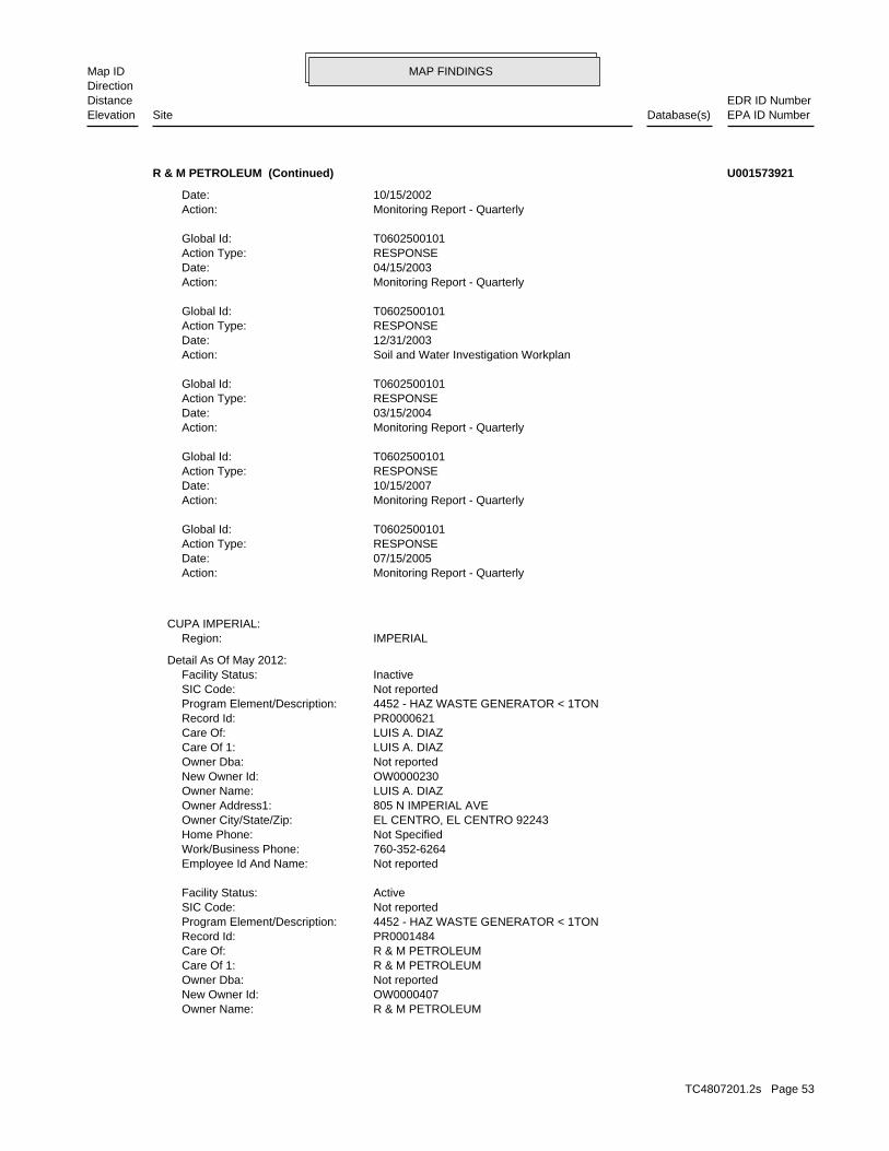
MAP FINDINGSMap IDDirection
EDR ID NumberDistanceEPA ID NumberDatabase(s)SiteElevation
R & M PETROLEUMOwner Name: OW0000407New Owner Id: Not reportedOwner Dba: R & M PETROLEUMCare Of 1: R & M PETROLEUMCare Of: PR0001484Record Id: 4452 - HAZ WASTE GENERATOR < 1TONProgram Element/Description: Not reportedSIC Code: ActiveFacility Status:
Not reportedEmployee Id And Name: 760-352-6264Work/Business Phone: Not SpecifiedHome Phone: EL CENTRO, EL CENTRO 92243Owner City/State/Zip: 805 N IMPERIAL AVEOwner Address1: LUIS A. DIAZOwner Name: OW0000230New Owner Id: Not reportedOwner Dba: LUIS A. DIAZCare Of 1: LUIS A. DIAZCare Of: PR0000621Record Id: 4452 - HAZ WASTE GENERATOR < 1TONProgram Element/Description: Not reportedSIC Code: InactiveFacility Status:
Detail As Of May 2012:
IMPERIALRegion:CUPA IMPERIAL:
Monitoring Report - QuarterlyAction: 07/15/2005Date: RESPONSEAction Type: T0602500101Global Id:
Monitoring Report - QuarterlyAction: 10/15/2007Date: RESPONSEAction Type: T0602500101Global Id:
Monitoring Report - QuarterlyAction: 03/15/2004Date: RESPONSEAction Type: T0602500101Global Id:
Soil and Water Investigation WorkplanAction: 12/31/2003Date: RESPONSEAction Type: T0602500101Global Id:
Monitoring Report - QuarterlyAction: 04/15/2003Date: RESPONSEAction Type: T0602500101Global Id:
Monitoring Report - QuarterlyAction: 10/15/2002Date:
R & M PETROLEUM (Continued) U001573921
TC4807201.2s Page 53

MAP FINDINGSMap IDDirection
EDR ID NumberDistanceEPA ID NumberDatabase(s)SiteElevation
Not reportedEmployee Id And Name: 805-541-1338Work/Business Phone: Not SpecifiedHome Phone: IRVINE, IRVINE 92614Owner City/State/Zip: 17895 SKY PARK CIRCLE, STE. EOwner Address2: 17895 SKY PARK CIR EOwner Address1: R & M PETROLEUMOwner Name: OW0000407New Owner Id: Not reportedOwner Dba: R & M PETROLEUMCare Of 1: R & M PETROLEUMCare Of: PR0001484Record Id: 4452 - HAZ WASTE GENERATOR < 1TONProgram Element/Description: Not reportedSIC Code: ActiveFacility Status:
Not reportedEmployee Id And Name: 760-352-6264Work/Business Phone: Not SpecifiedHome Phone: EL CENTRO, EL CENTRO 92243Owner City/State/Zip: 805 N IMPERIAL AVEOwner Address1: LUIS A. DIAZOwner Name: OW0000230New Owner Id: Not reportedOwner Dba: LUIS A. DIAZCare Of 1: LUIS A. DIAZCare Of: PR0000621Record Id: 4452 - HAZ WASTE GENERATOR < 1TONProgram Element/Description: Not reportedSIC Code: InactiveFacility Status:
Detail As Of May 2012:
IMPERIALRegion:
Not reportedEmployee Id And Name: 619-454-5956Work/Business Phone: Not SpecifiedHome Phone: EL CENTRO, EL CENTRO 92243Owner City/State/Zip: 825 NORTH IMPERIAL AVENOwner Address2: 825 N IMPERIAL AVEOwner Address1: NAHID TOMAOwner Name: OW0000756New Owner Id: Not reportedOwner Dba: NAHID TOMACare Of 1: NAHID TOMACare Of: PR0002802Record Id: 4452 - HAZ WASTE GENERATOR < 1TONProgram Element/Description: 7538SIC Code: ActiveFacility Status:
Not reportedEmployee Id And Name: 805-541-1338Work/Business Phone: Not SpecifiedHome Phone: IRVINE, IRVINE 92614Owner City/State/Zip: 17895 SKY PARK CIRCLE, STE. EOwner Address2: 17895 SKY PARK CIR EOwner Address1:
R & M PETROLEUM (Continued) U001573921
TC4807201.2s Page 54

MAP FINDINGSMap IDDirection
EDR ID NumberDistanceEPA ID NumberDatabase(s)SiteElevation
Not reportedOwner Dba: NAHID TOMACare Of 1: NAHID TOMACare Of: PR0002802Record Id: 4452 - HAZ WASTE GENERATOR < 1TONProgram Element/Description: 7538SIC Code: ActiveFacility Status:
Not reportedEmployee Id And Name: 805-541-1338Work/Business Phone: Not SpecifiedHome Phone: IRVINE, IRVINE 92614Owner City/State/Zip: 17895 SKY PARK CIRCLE, STE. EOwner Address2: 17895 SKY PARK CIR EOwner Address1: R & M PETROLEUMOwner Name: OW0000407New Owner Id: Not reportedOwner Dba: R & M PETROLEUMCare Of 1: R & M PETROLEUMCare Of: PR0001484Record Id: 4452 - HAZ WASTE GENERATOR < 1TONProgram Element/Description: Not reportedSIC Code: ActiveFacility Status:
Not reportedEmployee Id And Name: 760-352-6264Work/Business Phone: Not SpecifiedHome Phone: EL CENTRO, EL CENTRO 92243Owner City/State/Zip: 805 N IMPERIAL AVEOwner Address1: LUIS A. DIAZOwner Name: OW0000230New Owner Id: Not reportedOwner Dba: LUIS A. DIAZCare Of 1: LUIS A. DIAZCare Of: PR0000621Record Id: 4452 - HAZ WASTE GENERATOR < 1TONProgram Element/Description: Not reportedSIC Code: InactiveFacility Status:
Detail As Of May 2012:
IMPERIALRegion:
Not reportedEmployee Id And Name: 619-454-5956Work/Business Phone: Not SpecifiedHome Phone: EL CENTRO, EL CENTRO 92243Owner City/State/Zip: 825 NORTH IMPERIAL AVENOwner Address2: 825 N IMPERIAL AVEOwner Address1: NAHID TOMAOwner Name: OW0000756New Owner Id: Not reportedOwner Dba: NAHID TOMACare Of 1: NAHID TOMACare Of: PR0002802Record Id: 4452 - HAZ WASTE GENERATOR < 1TONProgram Element/Description: 7538SIC Code: ActiveFacility Status:
R & M PETROLEUM (Continued) U001573921
TC4807201.2s Page 55
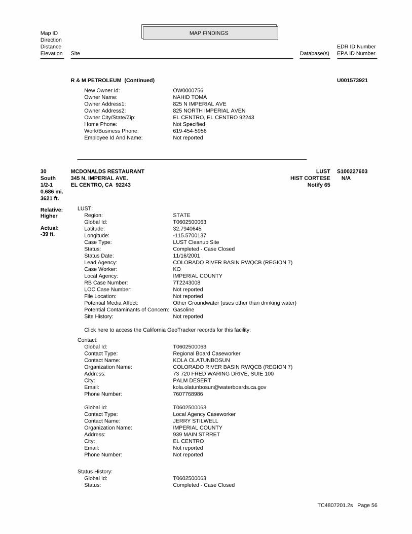
MAP FINDINGSMap IDDirection
EDR ID NumberDistanceEPA ID NumberDatabase(s)SiteElevation
Not reportedEmployee Id And Name: 619-454-5956Work/Business Phone: Not SpecifiedHome Phone: EL CENTRO, EL CENTRO 92243Owner City/State/Zip: 825 NORTH IMPERIAL AVENOwner Address2: 825 N IMPERIAL AVEOwner Address1: NAHID TOMAOwner Name: OW0000756New Owner Id:
R & M PETROLEUM (Continued) U001573921
Completed - Case ClosedStatus: T0602500063Global Id:
Status History:
Not reportedPhone Number: Not reportedEmail: EL CENTROCity: 939 MAIN STRRETAddress: IMPERIAL COUNTYOrganization Name: JERRY STILWELLContact Name: Local Agency CaseworkerContact Type: T0602500063Global Id:
7607768986Phone Number: [email protected]: PALM DESERTCity: 73-720 FRED WARING DRIVE, SUIE 100Address: COLORADO RIVER BASIN RWQCB (REGION 7)Organization Name: KOLA OLATUNBOSUNContact Name: Regional Board CaseworkerContact Type: T0602500063Global Id:
Contact:
Click here to access the California GeoTracker records for this facility:
Not reportedSite History: GasolinePotential Contaminants of Concern: Other Groundwater (uses other than drinking water)Potential Media Affect: Not reportedFile Location: Not reportedLOC Case Number: 7T2243008RB Case Number: IMPERIAL COUNTYLocal Agency: KOCase Worker: COLORADO RIVER BASIN RWQCB (REGION 7)Lead Agency: 11/16/2001Status Date: Completed - Case ClosedStatus: LUST Cleanup SiteCase Type: -115.5700137Longitude: 32.7940645Latitude: T0602500063Global Id: STATERegion:
LUST:
3621 ft.0.686 mi.
Relative:Higher
Actual:-39 ft.
1/2-1 Notify 65EL CENTRO, CA 92243South HIST CORTESE345 N. IMPERIAL AVE. N/A30 LUSTMCDONALDS RESTAURANT S100227603
TC4807201.2s Page 56

MAP FINDINGSMap IDDirection
EDR ID NumberDistanceEPA ID NumberDatabase(s)SiteElevation
Not reportedIncident Description: Not reportedIssue Date: Not reportedDischarge Date: Not reportedFacility Type: Not reportedBoard File Number: Not reportedStaff Initials: Not reportedDate Reported:
NOTIFY 65:
7T2243008Reg Id: LTNKAReg By: 13Facility County Code: CORTESERegion:
HIST CORTESE:
Leak DiscoveryAction: 11/24/1986Date: OtherAction Type: T0602500063Global Id:
Leak ReportedAction: 11/23/1987Date: OtherAction Type: T0602500063Global Id:
Free Product RemovalAction: 10/15/2000Date: REMEDIATIONAction Type: T0602500063Global Id:
Regulatory Activities:
08/14/2000Status Date: Open - Site AssessmentStatus: T0602500063Global Id:
06/27/1988Status Date: Open - Site AssessmentStatus: T0602500063Global Id:
05/09/1988Status Date: Open - Site AssessmentStatus: T0602500063Global Id:
11/23/1987Status Date: Open - Site AssessmentStatus: T0602500063Global Id:
11/24/1986Status Date: Open - Case Begin DateStatus: T0602500063Global Id:
11/16/2001Status Date:
MCDONALDS RESTAURANT (Continued) S100227603
TC4807201.2s Page 57

MAP FINDINGSMap IDDirection
EDR ID NumberDistanceEPA ID NumberDatabase(s)SiteElevation
No additional information availableManufactured Gas Plants:
4734 ft. Site 1 of 2 in cluster I0.897 mi.
Relative:Lower
Actual:-45 ft.
1/2-1 EL CENTRO, CA 92243ESE 970 NORTH 4TH STREET N/AI31 EDR MGPSO CAL GAS/EL CENTRO MGP 1008407674
Project Code (Site Code)Alias Type: 400801Alias Name: EPA (FRS #)Alias Type: 110033609539Alias Name: EPA Identification NumberAlias Type: CAD981423007Alias Name: APNAlias Type: 044-332-06-01Alias Name: APNAlias Type: 044-332-06-01Alias Name: Alternate NameAlias Type: TOWN GAS PLANT EL CENTRO #1Alias Name: Alternate NameAlias Type: SOUTHERN CALIFORNIA GAS COMPANYAlias Name: Alternate NameAlias Type: SOUTHERN CALIFORNIA GASAlias Name: SOILPotential Description: Polynuclear aromatic hydrocarbons (PAHsConfirmed COC: Polynuclear aromatic hydrocarbons (PAHsPotential COC: MANUFACTURED GAS PLANTPast Use: 044-332-06-01, 044-332-06-01APN: -115.5527Longitude: 32.80096Latitude: Responsible PartyFunding: ASP, DAY, ELD, HOS, EX, NUSE, NDEV, SCH, FOOD, RESSite Mgmt Req: YESRestricted Use: Voluntary Cleanup ProgramSpecial Program: 40Senate: 56Assembly: Cleanup CypressDivision Branch: Manny AlonzoSupervisor: Isaac HirbawiProgram Manager: SMBRPLead Agency: SMBRPRegulatory Agencies: NONPL: 2.3Acres: Voluntary CleanupSite Type Detailed: Voluntary CleanupSite Type: 400801Site Code: 12/19/2014Status Date: Certified O&M - Land Use Restrictions OnlyStatus: 13490015Facility ID:
ENVIROSTOR:
4734 ft. Site 2 of 2 in cluster I0.897 mi. HIST CORTESE
Relative:Lower
Actual:-45 ft.
1/2-1 DEEDEL CENTRO, CA 92243ESE VCP970 NORTH 4TH STREET N/AI32 ENVIROSTORSO CAL GAS/EL CENTRO MGP S105023615
TC4807201.2s Page 58

MAP FINDINGSMap IDDirection
EDR ID NumberDistanceEPA ID NumberDatabase(s)SiteElevation
removal action under the oversight of DTSC. necessary, to prepare a removal action workplan and implement a further characterize the existing soil contamination and, if Agreement is for the Proponent to conduct a Site Investigation to Southern California Gas Company (Proponent). The purpose of this DTSC entered into a Voluntary Cleanup Agreement (Agreement) withComments: 04/21/2000Completed Date: Voluntary Cleanup AgreementCompleted Document Type: Not reportedCompleted Sub Area Name: PROJECT WIDECompleted Area Name:
were no public comments. (SCH) to be approved and made available for public comments. There Upon finalizing the intial study, the CEQA document had been sent toComments: 04/02/2001Completed Date: CEQA - Initial Study/ Neg. DeclarationCompleted Document Type: Not reportedCompleted Sub Area Name: PROJECT WIDECompleted Area Name:
full-time human habitation). (residential, hospital, day care, school, and any use that includes 29, 2003. The deed restriction restricted sensitive land use restriction was recorded with Imprial County, recorded office on Aug. investigation, and remediation of the Site. ‘ DEED-RESTR: A deed Therefore, no further action is necessary with respect to not appear to pose a threat to human health or the environment. Docket No. HSA-97/98-014, signed on August 28, 1998. The Site does Cleanup Agreement between DTSC and Southern California Gas Company, a deed restriction, These activities were conducted under a Voluntary fill of the excavated area with clean imported soil, and recording of Site included excavation of contaminated soil, confirm sampling, back Action Plan (RAW) on April 20, 2001. The remedial activities at the Response Action/Notification. ‘ CERT-NFA: DTSC approved a Removal Monitoring, Annual Summary Reports, Five- Year Review, and Emergency Implementation of Operation and Maintenance Plans, Environmental Gas Company on Dec.18, 2003. The two parties agree on the following: OM-AGRMT: DTSC has signed an O&M Agreement with Southern CaliforniaComments: 12/16/2003Completed Date: CertificationCompleted Document Type: Not reportedCompleted Sub Area Name: PROJECT WIDECompleted Area Name:
Not reportedComments: 08/29/2003Completed Date: Land Use RestrictionCompleted Document Type: Not reportedCompleted Sub Area Name: PROJECT WIDECompleted Area Name:
Not reportedComments: 08/25/2006Completed Date: Land Use Restriction - Site Inspection/VisitCompleted Document Type: Not reportedCompleted Sub Area Name: PROJECT WIDECompleted Area Name:
Completed Info:
Envirostor ID NumberAlias Type: 13490015Alias Name:
SO CAL GAS/EL CENTRO MGP (Continued) S105023615
TC4807201.2s Page 59

MAP FINDINGSMap IDDirection
EDR ID NumberDistanceEPA ID NumberDatabase(s)SiteElevation
DTSC sent the letter.Comments: 07/11/2012Completed Date: Removal Action Completion ReportCompleted Document Type: Not reportedCompleted Sub Area Name: PROJECT WIDECompleted Area Name:
Not reportedComments: 04/11/2008Completed Date: Remedial Action Implementation WorkplanCompleted Document Type: Not reportedCompleted Sub Area Name: PROJECT WIDECompleted Area Name:
Final approval letter has been sent to the RPs.Comments: 03/27/2008Completed Date: Removal Action WorkplanCompleted Document Type: Not reportedCompleted Sub Area Name: PROJECT WIDECompleted Area Name:
Not reportedComments: 05/24/1991Completed Date: Site ScreeningCompleted Document Type: Not reportedCompleted Sub Area Name: PROJECT WIDECompleted Area Name:
Not reportedComments: 08/28/1992Completed Date: Preliminary Endangerment Assessment ReportCompleted Document Type: Not reportedCompleted Sub Area Name: PROJECT WIDECompleted Area Name:
confirmation soil samples, and dispose contaminated material offsite. area to a depth of 1 to 3 feet bgs, collect post-excavation RAW was approved. RAW proposed to excavate the entire contaminatedComments: 04/20/2001Completed Date: Removal Action WorkplanCompleted Document Type: Not reportedCompleted Sub Area Name: PROJECT WIDECompleted Area Name:
disposal. The excavated area was backfilled with clean soil. excavated and transported to a thermal treatment facility for final Approximately 11,051 tons of contaminated soil with PAHs wasComments: 11/20/2001Completed Date: Removal Action Completion ReportCompleted Document Type: Not reportedCompleted Sub Area Name: PROJECT WIDECompleted Area Name:
Not reportedComments: 08/27/2007Completed Date: Operations and Maintenance ReportCompleted Document Type: Not reportedCompleted Sub Area Name: PROJECT WIDECompleted Area Name:
Annual Cost Estimate completed.Comments: 10/20/2015Completed Date: Annual Oversight Cost EstimateCompleted Document Type: Not reportedCompleted Sub Area Name: PROJECT WIDECompleted Area Name:
SO CAL GAS/EL CENTRO MGP (Continued) S105023615
TC4807201.2s Page 60

MAP FINDINGSMap IDDirection
EDR ID NumberDistanceEPA ID NumberDatabase(s)SiteElevation
Completed.Comments: 10/04/2010Completed Date: Annual Oversight Cost EstimateCompleted Document Type: Not reportedCompleted Sub Area Name: PROJECT WIDECompleted Area Name:
Annual Cost Estimation letter sent.Comments: 08/28/2009Completed Date: Annual Oversight Cost EstimateCompleted Document Type: Not reportedCompleted Sub Area Name: PROJECT WIDECompleted Area Name:
Annual cost estimate letter sent to the RPs.Comments: 10/28/2008Completed Date: CorrespondenceCompleted Document Type: Not reportedCompleted Sub Area Name: PROJECT WIDECompleted Area Name:
for further remedial investigation. DTSC sent the De-certification letter to the RPs to reopen the SiteComments: 01/17/2008Completed Date: De-CertificationCompleted Document Type: Not reportedCompleted Sub Area Name: PROJECT WIDECompleted Area Name:
Annual Land Use Restriction Inspection completed.Comments: 09/25/2009Completed Date: Land Use Restriction - Site Inspection/VisitCompleted Document Type: Not reportedCompleted Sub Area Name: PROJECT WIDECompleted Area Name:
as per the agreed restrictions. cap is good and there were no prohibited activities being conducted inspection conducted on August 14, 2007. The general condition of the Annual Inspection report provided by Earth Tech summarized the siteComments: 08/14/2007Completed Date: Land Use Restriction - Site Inspection/VisitCompleted Document Type: Not reportedCompleted Sub Area Name: PROJECT WIDECompleted Area Name:
Signed LUC sent for recordation in the County.Comments: 06/20/2014Completed Date: Deed/LUR Enforcement & Implementation PlanCompleted Document Type: Not reportedCompleted Sub Area Name: PROJECT WIDECompleted Area Name:
DTSC letter sent.Comments: 07/11/2012Completed Date: Remedial Action Completion ReportCompleted Document Type: Not reportedCompleted Sub Area Name: PROJECT WIDECompleted Area Name:
Not reportedComments: 06/23/2011Completed Date: Technical WorkplanCompleted Document Type: Not reportedCompleted Sub Area Name: PROJECT WIDECompleted Area Name:
SO CAL GAS/EL CENTRO MGP (Continued) S105023615
TC4807201.2s Page 61

MAP FINDINGSMap IDDirection
EDR ID NumberDistanceEPA ID NumberDatabase(s)SiteElevation
Voluntary CleanupSite Type Detail: Voluntary CleanupSite Type: 13490015Facility ID:
VCP:
Not reportedSchedule Revised Date: Not reportedSchedule Due Date: Not reportedSchedule Document Type: Not reportedSchedule Sub Area Name: Not reportedSchedule Area Name: 2020Future Due Date: 5 Year Review ReportsFuture Document Type: Not reportedFuture Sub Area Name: PROJECT WIDEFuture Area Name:
Not reportedComments: 11/26/2013Completed Date: Annual Oversight Cost EstimateCompleted Document Type: Not reportedCompleted Sub Area Name: PROJECT WIDECompleted Area Name:
Recorded in the County. Original recorded LUC received in October.Comments: 06/20/2014Completed Date: Land Use RestrictionCompleted Document Type: Not reportedCompleted Sub Area Name: PROJECT WIDECompleted Area Name:
Docket No. HSA-97/98-014, signed on December 18, 2003. An O&M agreement between DTSC and Southern California Gas Company ,Comments: 12/18/2003Completed Date: Operation & Maintenance Order/AgreementCompleted Document Type: Not reportedCompleted Sub Area Name: PROJECT WIDECompleted Area Name:
CompletedComments: 10/15/2014Completed Date: CertificationCompleted Document Type: Not reportedCompleted Sub Area Name: PROJECT WIDECompleted Area Name:
Completed.Comments: 09/26/2011Completed Date: Land Use Restriction - Site Inspection/VisitCompleted Document Type: Not reportedCompleted Sub Area Name: PROJECT WIDECompleted Area Name:
completedComments: 11/10/2010Completed Date: Land Use Restriction - Site Inspection/VisitCompleted Document Type: Not reportedCompleted Sub Area Name: PROJECT WIDECompleted Area Name:
Not reportedComments: 10/10/2011Completed Date: Annual Oversight Cost EstimateCompleted Document Type: Not reportedCompleted Sub Area Name: PROJECT WIDECompleted Area Name:
SO CAL GAS/EL CENTRO MGP (Continued) S105023615
TC4807201.2s Page 62

MAP FINDINGSMap IDDirection
EDR ID NumberDistanceEPA ID NumberDatabase(s)SiteElevation
CertificationCompleted Document Type: Not reportedCompleted Sub Area Name: PROJECT WIDECompleted Area Name:
Not reportedComments: 08/29/2003Completed Date: Land Use RestrictionCompleted Document Type: Not reportedCompleted Sub Area Name: PROJECT WIDECompleted Area Name:
Not reportedComments: 08/25/2006Completed Date: Land Use Restriction - Site Inspection/VisitCompleted Document Type: Not reportedCompleted Sub Area Name: PROJECT WIDECompleted Area Name:
Completed Info:
Envirostor ID NumberAlias Type: 13490015Alias Name: Project Code (Site Code)Alias Type: 400801Alias Name: EPA (FRS #)Alias Type: 110033609539Alias Name: EPA Identification NumberAlias Type: CAD981423007Alias Name: APNAlias Type: 044-332-06-01Alias Name: APNAlias Type: 044-332-06-01Alias Name: Alternate NameAlias Type: TOWN GAS PLANT EL CENTRO #1Alias Name: Alternate NameAlias Type: SOUTHERN CALIFORNIA GAS COMPANYAlias Name: Alternate NameAlias Type: SOUTHERN CALIFORNIA GASAlias Name: SOILPotential Description: 30019Confirmed COC: 30019Potential COC: MANUFACTURED GAS PLANTPast Use: 044-332-06-01, 044-332-06-01APN: 32.80096 / -115.5527Lat/Long: Responsible PartyFunding: YESRestricted Use: 12/19/2014Status Date: Certified O&M - Land Use Restrictions OnlyStatus: Voluntary Cleanup ProgramSpecial Programs Code: 40Senate: 56Assembly: 400801Site Code: Cleanup CypressDivision Branch: Manny AlonzoSupervisor: Isaac HirbawiProject Manager: DTSC - Site Cleanup ProgramLead Agency Description: SMBRPLead Agency: SMBRPCleanup Oversight Agencies: NONational Priorities List: 2.3Acres: ASP, DAY, ELD, HOS, EX, NUSE, NDEV, SCH, FOOD, RESSite Mgmt. Req.:
SO CAL GAS/EL CENTRO MGP (Continued) S105023615
TC4807201.2s Page 63

MAP FINDINGSMap IDDirection
EDR ID NumberDistanceEPA ID NumberDatabase(s)SiteElevation
excavated and transported to a thermal treatment facility for final Approximately 11,051 tons of contaminated soil with PAHs wasComments: 11/20/2001Completed Date: Removal Action Completion ReportCompleted Document Type: Not reportedCompleted Sub Area Name: PROJECT WIDECompleted Area Name:
Not reportedComments: 08/27/2007Completed Date: Operations and Maintenance ReportCompleted Document Type: Not reportedCompleted Sub Area Name: PROJECT WIDECompleted Area Name:
Annual Cost Estimate completed.Comments: 10/20/2015Completed Date: Annual Oversight Cost EstimateCompleted Document Type: Not reportedCompleted Sub Area Name: PROJECT WIDECompleted Area Name:
removal action under the oversight of DTSC. necessary, to prepare a removal action workplan and implement a further characterize the existing soil contamination and, if Agreement is for the Proponent to conduct a Site Investigation to Southern California Gas Company (Proponent). The purpose of this DTSC entered into a Voluntary Cleanup Agreement (Agreement) withComments: 04/21/2000Completed Date: Voluntary Cleanup AgreementCompleted Document Type: Not reportedCompleted Sub Area Name: PROJECT WIDECompleted Area Name:
were no public comments. (SCH) to be approved and made available for public comments. There Upon finalizing the intial study, the CEQA document had been sent toComments: 04/02/2001Completed Date: CEQA - Initial Study/ Neg. DeclarationCompleted Document Type: Not reportedCompleted Sub Area Name: PROJECT WIDECompleted Area Name:
full-time human habitation). (residential, hospital, day care, school, and any use that includes 29, 2003. The deed restriction restricted sensitive land use restriction was recorded with Imprial County, recorded office on Aug. investigation, and remediation of the Site. ‘ DEED-RESTR: A deed Therefore, no further action is necessary with respect to not appear to pose a threat to human health or the environment. Docket No. HSA-97/98-014, signed on August 28, 1998. The Site does Cleanup Agreement between DTSC and Southern California Gas Company, a deed restriction, These activities were conducted under a Voluntary fill of the excavated area with clean imported soil, and recording of Site included excavation of contaminated soil, confirm sampling, back Action Plan (RAW) on April 20, 2001. The remedial activities at the Response Action/Notification. ‘ CERT-NFA: DTSC approved a Removal Monitoring, Annual Summary Reports, Five- Year Review, and Emergency Implementation of Operation and Maintenance Plans, Environmental Gas Company on Dec.18, 2003. The two parties agree on the following: OM-AGRMT: DTSC has signed an O&M Agreement with Southern CaliforniaComments: 12/16/2003Completed Date:
SO CAL GAS/EL CENTRO MGP (Continued) S105023615
TC4807201.2s Page 64

MAP FINDINGSMap IDDirection
EDR ID NumberDistanceEPA ID NumberDatabase(s)SiteElevation
Signed LUC sent for recordation in the County.Comments: 06/20/2014Completed Date: Deed/LUR Enforcement & Implementation PlanCompleted Document Type: Not reportedCompleted Sub Area Name: PROJECT WIDECompleted Area Name:
DTSC letter sent.Comments: 07/11/2012Completed Date: Remedial Action Completion ReportCompleted Document Type: Not reportedCompleted Sub Area Name: PROJECT WIDECompleted Area Name:
Not reportedComments: 06/23/2011Completed Date: Technical WorkplanCompleted Document Type: Not reportedCompleted Sub Area Name: PROJECT WIDECompleted Area Name:
DTSC sent the letter.Comments: 07/11/2012Completed Date: Removal Action Completion ReportCompleted Document Type: Not reportedCompleted Sub Area Name: PROJECT WIDECompleted Area Name:
Not reportedComments: 04/11/2008Completed Date: Remedial Action Implementation WorkplanCompleted Document Type: Not reportedCompleted Sub Area Name: PROJECT WIDECompleted Area Name:
Final approval letter has been sent to the RPs.Comments: 03/27/2008Completed Date: Removal Action WorkplanCompleted Document Type: Not reportedCompleted Sub Area Name: PROJECT WIDECompleted Area Name:
Not reportedComments: 05/24/1991Completed Date: Site ScreeningCompleted Document Type: Not reportedCompleted Sub Area Name: PROJECT WIDECompleted Area Name:
Not reportedComments: 08/28/1992Completed Date: Preliminary Endangerment Assessment ReportCompleted Document Type: Not reportedCompleted Sub Area Name: PROJECT WIDECompleted Area Name:
confirmation soil samples, and dispose contaminated material offsite. area to a depth of 1 to 3 feet bgs, collect post-excavation RAW was approved. RAW proposed to excavate the entire contaminatedComments: 04/20/2001Completed Date: Removal Action WorkplanCompleted Document Type: Not reportedCompleted Sub Area Name: PROJECT WIDECompleted Area Name:
disposal. The excavated area was backfilled with clean soil.
SO CAL GAS/EL CENTRO MGP (Continued) S105023615
TC4807201.2s Page 65

MAP FINDINGSMap IDDirection
EDR ID NumberDistanceEPA ID NumberDatabase(s)SiteElevation
Completed.Comments: 09/26/2011Completed Date: Land Use Restriction - Site Inspection/VisitCompleted Document Type: Not reportedCompleted Sub Area Name: PROJECT WIDECompleted Area Name:
completedComments: 11/10/2010Completed Date: Land Use Restriction - Site Inspection/VisitCompleted Document Type: Not reportedCompleted Sub Area Name: PROJECT WIDECompleted Area Name:
Not reportedComments: 10/10/2011Completed Date: Annual Oversight Cost EstimateCompleted Document Type: Not reportedCompleted Sub Area Name: PROJECT WIDECompleted Area Name:
Completed.Comments: 10/04/2010Completed Date: Annual Oversight Cost EstimateCompleted Document Type: Not reportedCompleted Sub Area Name: PROJECT WIDECompleted Area Name:
Annual Cost Estimation letter sent.Comments: 08/28/2009Completed Date: Annual Oversight Cost EstimateCompleted Document Type: Not reportedCompleted Sub Area Name: PROJECT WIDECompleted Area Name:
Annual cost estimate letter sent to the RPs.Comments: 10/28/2008Completed Date: CorrespondenceCompleted Document Type: Not reportedCompleted Sub Area Name: PROJECT WIDECompleted Area Name:
for further remedial investigation. DTSC sent the De-certification letter to the RPs to reopen the SiteComments: 01/17/2008Completed Date: De-CertificationCompleted Document Type: Not reportedCompleted Sub Area Name: PROJECT WIDECompleted Area Name:
Annual Land Use Restriction Inspection completed.Comments: 09/25/2009Completed Date: Land Use Restriction - Site Inspection/VisitCompleted Document Type: Not reportedCompleted Sub Area Name: PROJECT WIDECompleted Area Name:
as per the agreed restrictions. cap is good and there were no prohibited activities being conducted inspection conducted on August 14, 2007. The general condition of the Annual Inspection report provided by Earth Tech summarized the siteComments: 08/14/2007Completed Date: Land Use Restriction - Site Inspection/VisitCompleted Document Type: Not reportedCompleted Sub Area Name: PROJECT WIDECompleted Area Name:
SO CAL GAS/EL CENTRO MGP (Continued) S105023615
TC4807201.2s Page 66
MAP FINDINGSMap IDDirection
EDR ID NumberDistanceEPA ID NumberDatabase(s)SiteElevation
CORTESERegion:HIST CORTESE:
06/20/2014Deed Date(s): Not reportedCovenant Uploaded:Not reportedAgency:CERTIFIED O&M - LAND USE RESTRICTIONS ONLYStatus:VOLUNTARY CLEANUPSite Type:Not reportedSub Area:PROJECT WIDEArea:13490015Envirostor ID:
08/29/2003Deed Date(s): Not reportedCovenant Uploaded:Not reportedAgency:CERTIFIED O&M - LAND USE RESTRICTIONS ONLYStatus:VOLUNTARY CLEANUPSite Type:Not reportedSub Area:PROJECT WIDEArea:13490015Envirostor ID:
DEED:
Not reportedSchedule Revised Date: Not reportedSchedule Due Date: Not reportedSchedule Document Type: Not reportedSchedule Sub Area Name: Not reportedSchedule Area Name: 2020Future Due Date: 5 Year Review ReportsFuture Document Type: Not reportedFuture Sub Area Name: PROJECT WIDEFuture Area Name:
Not reportedComments: 11/26/2013Completed Date: Annual Oversight Cost EstimateCompleted Document Type: Not reportedCompleted Sub Area Name: PROJECT WIDECompleted Area Name:
Recorded in the County. Original recorded LUC received in October.Comments: 06/20/2014Completed Date: Land Use RestrictionCompleted Document Type: Not reportedCompleted Sub Area Name: PROJECT WIDECompleted Area Name:
Docket No. HSA-97/98-014, signed on December 18, 2003. An O&M agreement between DTSC and Southern California Gas Company ,Comments: 12/18/2003Completed Date: Operation & Maintenance Order/AgreementCompleted Document Type: Not reportedCompleted Sub Area Name: PROJECT WIDECompleted Area Name:
CompletedComments: 10/15/2014Completed Date: CertificationCompleted Document Type: Not reportedCompleted Sub Area Name: PROJECT WIDECompleted Area Name:
SO CAL GAS/EL CENTRO MGP (Continued) S105023615
TC4807201.2s Page 67

MAP FINDINGSMap IDDirection
EDR ID NumberDistanceEPA ID NumberDatabase(s)SiteElevation
7T2243011Reg Id: LTNKAReg By: 13Facility County Code:
SO CAL GAS/EL CENTRO MGP (Continued) S105023615
Not reportedSchedule Revised Date: Not reportedSchedule Due Date: Not reportedSchedule Document Type: Not reportedSchedule Sub Area Name: Not reportedSchedule Area Name: Not reportedFuture Due Date: Not reportedFuture Document Type: Not reportedFuture Sub Area Name: Not reportedFuture Area Name:
Not reportedComments: 10/16/2003Completed Date: Corrective Measures Study WorkplanCompleted Document Type: Not reportedCompleted Sub Area Name: PROJECT WIDECompleted Area Name:
Completed Info:
Envirostor ID NumberAlias Type: 71003757Alias Name: SOILPotential Description: NONE SPECIFIEDConfirmed COC: NONE SPECIFIEDPotential COC: OPEN BURN/OPEN DETONATIONPast Use: NONE SPECIFIEDAPN: -115.5630Longitude: 32.792Latitude: Not reportedFunding: NONE SPECIFIEDSite Mgmt Req: NORestricted Use: Not reportedSpecial Program: 40Senate: 56Assembly: Cleanup CypressDivision Branch: Not reportedSupervisor: Not reportedProgram Manager: NONE SPECIFIEDLead Agency: NONE SPECIFIEDRegulatory Agencies: NONPL: Not reportedAcres: Tiered PermitSite Type Detailed: Tiered PermitSite Type: Not reportedSite Code: Not reportedStatus Date: No Further ActionStatus: 71003757Facility ID:
ENVIROSTOR:
5169 ft.0.979 mi.
Relative:Higher
Actual:-40 ft.
1/2-1 EL CENTRO, CA 92243SSE DOGWOOD AND CHICK ROADS N/A33 ENVIROSTORJ.R. SIMPLOT S110493951
TC4807201.2s Page 68
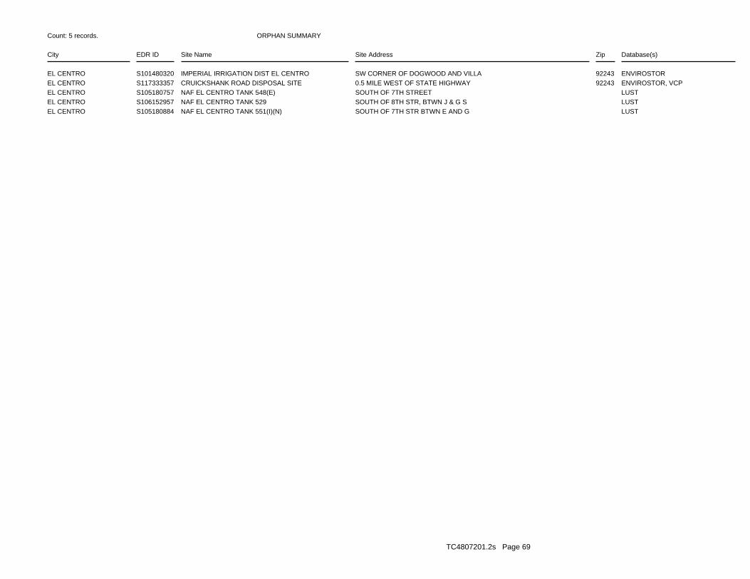
ORPHAN SUMMARY
City EDR ID Site Name Site Address Zip Database(s)
Count: 5 records.
EL CENTRO S101480320 IMPERIAL IRRIGATION DIST EL CENTRO SW CORNER OF DOGWOOD AND VILLA 92243 ENVIROSTOREL CENTRO S117333357 CRUICKSHANK ROAD DISPOSAL SITE 0.5 MILE WEST OF STATE HIGHWAY 92243 ENVIROSTOR, VCPEL CENTRO S105180757 NAF EL CENTRO TANK 548(E) SOUTH OF 7TH STREET LUSTEL CENTRO S106152957 NAF EL CENTRO TANK 529 SOUTH OF 8TH STR, BTWN J & G S LUSTEL CENTRO S105180884 NAF EL CENTRO TANK 551(I)(N) SOUTH OF 7TH STR BTWN E AND G LUST
TC4807201.2s Page 69