Embed Size (px)
Citation preview
He Mo‘olelo ‘Āina: Kumu Pono Associates LLC A Cultural Study of the Manukā Natural Area Reserve 134 HiNARS80-Manuka (072004)
growth of scrub ohia, pukeawe &c., the side toward the mountain is smooth regular outline, all the higher knolls being on the makai side. The natives say when the Kona winds are blowing a whirl wind is formed sending up clouds of sand &c, elevation 5430 feet. At an elevation of 4820 feet there is a rocky knoll, the line of boundary follows along this knoll on black aa from Kahonupu to Puuohoohia [Puu Ohohia]; Kahonopu from this point appears to be two large rocks on the pahoehoe with scrub ohia around them. Hapaimamo in Kahuku is a large smooth hill formed of pumice and sand with red spots on it and on the plain around it. It is an old crater with a gap in the south side where a stream of aa has flowed out. R.A. Lyman Boundary Commissioner 3 J.C… Kauhuhuula March 21st 1873. Boundary Commission met at 2 p.m. according to adjournment. Present: Geo. W.C. Jones, C.E. Richardson, J. Kauhane on part of Hawaiian Government for Kau lands, W.K. Moi, actg. for J.G. Hoapili for Hawaiian Government lands in Kona, Crown Commissioner and Her Ex. R. Keelikolani, F.S. Lyman, &c. [page 150] …Office of Boundary Commission Hilo May 14th 1873. The Boundary Commission met to take testimony of Kenoi and Awakamanu, as to boundaries of Kahuku, after due notice to all parties interested. Present: Geo. W.C. Jones, C.E. Richardson and W.H. Reed on part of applicants; J. Kauhane for Hawaiian Government, W.P. Ragsdale, acting for J.G. Hoapili on part of Crown Com- missioner and Hawaiian Government… [page 155] Awakamanu K. Sworn I was born at Kahuku at time of Okuu [1804] and lived there until the time of Hookupu mamo at Ka Lae (1835) in time of Kamehameha III. Am a kamaaina of Kahuku, now live on Olaa in Puna. I used to go after birds, and the boundaries were pointed out to me by Moo K. for if we of Kahuku caught birds on other lands, they were taken away from us. Kalaehumuhumu is boundary between Manuka, and Kahuku; thence to Awaawa
He Mo‘olelo ‘Āina: Kumu Pono Associates LLC A Cultural Study of the Manukā Natural Area Reserve 135 HiNARS80-Manuka (072004)
called Kahiawai by the road. Kahuku running on this side; thence to a large hole with water in it, called Kamokulimu; thence to Puulonolono, a grove of trees; the boundary on Kona side of grove; thence to hill called Puuhoohia. Manuka ends at this hill and Kahuku runs over to Ohialele cutting off the land of Kaulanamauna and Kapua and Honomalino. Ohialele is a mound with a cave. From this point you can see the surf break at Kapua. Kahuku joins land of Keauhou at Pauewalu (a place where Moo K. killed eight Kona men. They shut him up in a cave and when he got out he killed them.) From Ohialele the boundary [page 156] between Kahuku and Honomalino runs to a grove of trees called Kamokupukala, Ohia trees on the pahoehoe beyond Ohialele. I think about a mile distant. Kamokupukala is on Kahuku; the boundary between Honomalino and Kahuku runs makai of this grove to Pauewalu above the woods. Pauewalu is a lae aa a long distance from Ohialele. Ohialele is a high ridge of Aa that breaks through when you walk on it, and is about half way between Puuohoohia [Puu Ohohia] and Pauewalu. Honomalino reaches to this point. I think we never went beyond here to catch birds as Keauhou folks would take them away. The boundary between Kahuku and Keauhou runs mauka to a water hole, Waio, where the cattle that were let go from Holualoa used to drink. I do not know as I could identify the place now. The high aa is boundary. Kahuku is on Kau side of aa. There are two small hills near the aa a good ways above Umi’s road. The water hole, Waio is close to the foot of the mountain, mamani grows there. The aa from Pauewalu ending before you reach the hole. Cannot see woods from there. Do not know anything about the boundary of Kahuku and Keauhou above this place. Pakininui joins Kahuku at Kulauala and runs up in to the woods to Kilohana. The koa is all on Kahuku, the Pele o ike is in the woods. I have not been up the boundaries through these woods. Went to Apoohina. There Moo K. told me Kahuku and Kapapala and Makaka joined. Makaka makai and Kapapala on the North side of Apoohina… [page 157]
Kahuku, Kau Island of Hawaii Boundary Commission Volume B:310-314 The Ahupuaa of Kahuku, District of Kau, Island of Hawaii, 3rd J.C. On this the 6th day of November, A.D. 1874 the Commissioner of Boundaries for the
He Mo‘olelo ‘Āina: Kumu Pono Associates LLC A Cultural Study of the Manukā Natural Area Reserve 136 HiNARS80-Manuka (072004)
Island of Hawaii, 3rd J.C., met at Waiohinu, Kau, on the application of ______[blank]______. Continued from folio 158, Book A or No. 1 Testimony on Kahuku, Kau, Hawaii. Waihou, Kahuku, November 6th, 1874 Present: G.W. C. Jones & C.E. Richardson. The Commissioner of Boundaries went to look at boundaries between Nakeaa, Waiopua, Mohoae and Kahuku… [page 310] R.A. Lyman Boundary Commissioner, 3rd J.C. Letter from W.D. Alexander to R.A. Lyman, Esq.. Honolulu, Sept. 21st, 1874 R.A. Lyman, Esq. Dear Sir: In regard to the boundaries of Kahuku in Kau, Hawaii, I can only state what was told me by the Kau people, when I surveyed part of Kahuku in 1859. I did not survey the line between [page 311] Kahuku and Manukaa. The old kamaainas however all agreed that Kahuku cut off all the lands of South Kona at the upper edge of the forest, as they expressed it, wherever the “ua‘us” were found, that was Kahuku. They testified that Kahuku extended in a northerly direction to Ahua Umi which lies between Hualalai and Mauna Loa. On the other side they testified that Kahuku in like manner cut off all the lands in Kau at the upper edge of the bush (the “wahi oneanea” being Kahuku), as far as Makaaka, near Keaiwa. From thence they said the boundary turned mauka and ran up to Pohaku Hanalei. I think, however, it was a question whether the summit crater of Mokuaweoweo belonged to Kahuku or Kapapala. I gave Mr. Armstrong, then President of the Board of Education, a written statement at the time, with estimates of the amount of arable,
He Mo‘olelo ‘Āina: Kumu Pono Associates LLC A Cultural Study of the Manukā Natural Area Reserve 137 HiNARS80-Manuka (072004)
land, grazing land, Koa timber &c, on the land, but I understand that all the papers were burned up with Mr. Brown’s house at the time of the great eruption of 1868. Yours truly, W.D. Alexander. Journal of trip to look at the boundaries of Keauhou 2 & Kahuku &c. Nov. 10th 1874. Left Pahoehoe, South Kona 9 o’clock a.m. Went through woods Kukuiopae & Kolo in 4 hours, got to cave called Keanapaakai in 5 hours. Kamaainas Kaauhana & Komaka say this cave is where Konomanu [bird catchers] of Kona, Kahuku, Hilo & Hamakua used to meet. Went from there to cave called Puliilii at elevation of 5550 feet in 5½ hours, slept at Ahu o Keoua ½ mile mauka of cave, is Umi’s lower road, at that point road paved with flat rocks. Kauhale o Keoua, Ahu o Keoua, 3 piles of stones. These three piles of stone can be seen distinctly from Keanapaakai. Nov. 11th. Komaka & Kaanana sworn to point out boundaries as they knew them. [page 312] Left camp at half past 6 a.m., passed spring called Paahulu to cave called Kapai where sandal wood gatherers used to live just above Koa woods, Kukuiopae 1st ;next went on to old mauu, which kamaaina say extends from a little mauka of where we were to makai of upper Govt. road, and land extends to mauka end of it. Kukui- opae 2nd extends to awaawa on the Kona side of goat pen, above the woods. Kukuioape 1 to Keauhou 2, on the Kona side of awaawa 2. Got to spring called Poliwai in mamani. In time of Kamehameha III used to chase goats all around to Poha. Have here [heard]. Kaohe is along here, do not know where it ends. Elevation 6100 ft. thence to Ahua a short distance, where can just see top of Mauna Loa, quite a hollow on left, facing mountain filled with mamane trees, called Kamakaele, ridge just across awaawa; land of Alae. There is a hill beyond Lumia, Honokua. Kaohe is makai and on the Kau side of the hill. The way is mauka of ahu 4 piles of stones. Puuulaula, a long ridge parallel with Mauna Loa, way mauka, half way between Ahua Keoua and Poliwai, water hole makai of Kualapa called Umiwai, not a long distance (½ mile perhaps). Next on to Puuoluamanu hill, a small crater, and awaawa, makai. Road from here to Alae runs makai of this place to tall tree in
He Mo‘olelo ‘Āina: Kumu Pono Associates LLC A Cultural Study of the Manukā Natural Area Reserve 138 HiNARS80-Manuka (072004)
woods. Crossed Honokua, old trail, goat pen running makai, going over aa, and across aa that runs down to Waiea; then small strip of pahoehoe mauka of koa woods on Kalahiki; thence came a good way to trail up from Kealia. Lae mamani, said to be on Hookena, is on north side of Kealia trail; went in a northerly direction and into point of koa woods where several water pools are mauka and makai of trail some distance apart. Camped ¼ past 3 P.M. Largest pool makai has rushes in it, called Komakawai, found by guides when chasing goats a few years since. Elevation of camp 8800 feet. Nov. 12th. Left camp at 7:40 A.M. frost and ice all over grass from shower last evening. Strawberry [_____] leaves covered with ice. Came through Koa and Mamani 1 hour and 20 minutes. Frost on grass in shade at 9 o’clock. Across aa, highest point on aa 7300 feet [page 313] directly makai of black aa on side of mountain. Aa partly covered over with grass & bushes, and down Pahoehoe; got to camp in Koa grove on Pahoehoe 4,000 feet at half past 3 P.M. Nov. 13th. Left camp at ½ past 7 A.M. Came down across pahoehoe, through Mamani and got into Koa woods, then struck across towards Hualalai until we came to an old aa flow; then followed down south edge of aa into woods, until after 4.00 P.M. Camped at elevation of 4300 feet. Nov. 14th. Left camp a little before 7 A.M., made a road through woods and reached Kealakekua at 2.00 P.M., making six days traveling from Hilo to Kona. Divide between Kahuku & Keauhou. R.A. Lyman Com. of Boundaries, 3d J.C… [page 314]
Kahuku, District of Kau, Island of Hawaii, Boundary Commission, Volume B:315-319 The Ahupuaa of Kahuku, District of Kau, Island of Hawaii, 3rd J.C. Case continued from November 14, 1874 See folio 314, Book B. Keopuka, S. Kona, November 16, 1874.
He Mo‘olelo ‘Āina: Kumu Pono Associates LLC A Cultural Study of the Manukā Natural Area Reserve 139 HiNARS80-Manuka (072004)
Due notice of hearing personally served on owners or agents of adjoining lands as far as known. Present: C.E. Richardson on part of owners of Kahuku; S.K. Kaai and J.G. Hoapili on part of Administrator of Estate M. Kekuanaoa, Hawaiian Government, Crown Lands, R. Keelikolani, Madam Akahi, Mrs. C.R. Bishop & Honorable C.R. Bishop, &c, &c. Wall also present. Testimony Rev. J.D. Paris, sworn, says, I came to Hawaii in 1841. I now live in Kona, Hawaii, have lived in Kona since 1852. Lived in Kau at Waiohinu from 1841 to 1849, from 1849 to 1852, was on visit to the States. I know land of Kahuku in Kau, and Keauhou 2d in N. Kona. I have heard about some of the boundaries of Keauhou and Kahuku. While I was in Kau I heard about Ka- huku in 1847. When Kamehameha III went on the mountain he stopped at my house on the way up and on the way back. I heard from them that they went up on Kahuku. Dr. Judd and C.G. Hopkins, were in the party. They said that they went on the mountain and I understood them to say that the boundary of Kahuku ran on this, the Kona side of the mountain; I heard while I was in Kau, I think from the kamaaina of Kahuku, that the boundary of Kahuku ran along Umi’s road to Ahua o Umi taking [page 315] the top of the mountain. I did not know where the road was & often went to Kahuku to hold meetings with the people, but did not talk with them about boundaries, but sometimes overheard them talking and asked some questions. I afterwards asked where Keauhou and Kahuku joined, think that it was when Prof. Alexander was going to survey Kahuku. I went with him as far as Milolii in South Kona and had some talk with kamaaina about boundaries. I think it was at that time that I was told that Kahuku joined Keauhou. I did not hear where, but got the im- pression that it was above here as the goat catchers in S. Kona told me that they got their goats from Kahuku, where they went in the mountains, as most of the goats were on Kahuku.
He Mo‘olelo ‘Āina: Kumu Pono Associates LLC A Cultural Study of the Manukā Natural Area Reserve 140 HiNARS80-Manuka (072004)
At that time I understood that Kahuku cut off all Kona lands to mauka of Kealakekua and Onouli nui. Several years afterwards I heard that Keauhou cut off all the Kona lands and lay between Kona lands and Kahuku, but I do not remember who the parties were who gave me the information. When I first came to Kau and Kona, there were a good many old men living who were said to be kamaainas. I think they are most all dead. I do not remember Kumauna and Awakamanu, but remember Kila. A good many natives took English names and I do not remember their other names. The time I went to Milolii with Alexander was the time that he was on the way to survey the land, and he was making inquiries about the land and I got the general impression in the talk with the kamaaina that the boundary runs on this side of the mountain. I asked questions for Alexander, and they said the boundary ran along to Umi’s road to the Hale a Umi. They said that [page 316] there were some piles of stones there. I did not know about the Ahu o Umi until 1859; I do not remember what year Alexander surveyed it. I bought the land of Kealakekua in 1863. I had the im- pression from my talks with kamaainas at that time that Kealakekua ran up to Alanui o Umi and joined on to Kahuku on South side and Keau- hou on north side. I understood that it ran through the woods to Alanui o Umi, but do not remember who told me so. I understood that other lands ran upon South side of Kealakekua and joined on to Kahuku, Kahauloa on South and Kahuku on the east. I thought as I went through Kona on tours that the na- tives got the goats on Kahuku from the mountain, but can not say that they told me so. C.X.d. By S.K. Kaai. At time Kamehameha III went on to the mountain I understood that Umi’s road ran from Kau to Kona. I do not know where the boundary of Kahuku joined Umi’s road. Thought
He Mo‘olelo ‘Āina: Kumu Pono Associates LLC A Cultural Study of the Manukā Natural Area Reserve 141 HiNARS80-Manuka (072004)
it was between Manukaa and place where Wall lives. I do not know where the Hale o Umi stood, but that it was on this side of the mountain. Afterwards heard after I bought land of Kealakekua [_____], Keauhou, that it ran mauka of South Kona lands. Did not get the kamaaina at Milolii as he, Alexander, was on the way to Kau to get kamaaina. By J.G.Hoapili The mountain I am talking about is Mauna Loa. At Milolii the natives said that Kahuku ran beyond the top of the mountain - Mauna Loa. Komaka K., sworn On the mountain. Continuation of examination as all parties are represented. [page 318] I was born at Kukuiopae, Kona. I was told that I was a year old when Naihe died [1831] at Kealakekua. I now live at Kukuiopae. Have seen the land of Kahuku, and have heard about the land of Kahuku from Kuaio, an old bird catcher, my kupuna kane. He is dead. I lived on the mountain with my father, Paihiha from Hualalai to the Palilua. He was a kamaaina of the mountain, a bird catcher. I went with him after goats. My kupuna kane told me that the boundary of Kahuku ran along Kona from Ohialele mauka of Kaapuna and Kipahoehoe to Na Hale o Umi. Ohialele is a cave near woods, sometimes water there. It is on Kau side of Koa grove called Ahinui. Thence the boundary runs mauka to Na Hale o Umi, some stone houses on Kau side of Paepu to Umi’s upper road; thence along road to Na Ahu o Umi, do not know which ahu. Have heard there were 6 hills of stones for the 6 districts. Was told that it was bounded by Keauhou makai of road. Have heard that Humuula bounds it on the other side. My kupuna told me the birds on the mountain belonged to Keauhou and Kahuku; did not hear where the division was. I was told that a Kau bird catcher, named Kau, killed a Keauhou bird catcher at Keanapaakai mauka of Kolo, and put his bones in the cave. I also heard that Kahuku
He Mo‘olelo ‘Āina: Kumu Pono Associates LLC A Cultural Study of the Manukā Natural Area Reserve 142 HiNARS80-Manuka (072004)
and Keauhou bird catchers fought at Pauewalu and elsewhere. Do not know which side was victorious at Pauewalu. I have seen Pauewalu, a cave on Pahoehoe. It is some distance makai of Umi’s upper road, and mauka of Land of Pahoehoe. C.X.d. I was old enough to go on the mountain when my kupuna kane died, but not old enough to carry burdens. I did not recollect these [page 318] things about boundaries from my kupuna kane, telling me, but when my father, Paihipa told them to me, I remembered that I had already heard the same things from my kupuna kane. My father told me about the boundary from Ohialele to Na Hale o Umi. I can not say how many times I went there with my father, 5 or 6 times, as I often went there for goats with him. It was said that Kuakini’s goats from Alika got on the mountain, and goats from Kahuku belonging to Puuaiole & Puu also went on to the mountain, and Palila on Hualalai. I was grown, I think it was in 1848, when we went after goats at Hualalai. Kapeau was governor. And when at Palilua, Leleiohoku was governor. When we were after goats at Palinui at Keanapaakai, Naaniani said the goats belonged to Kuakini or the Governor, and Kila said they belonged to Kahuku, but gave in to Naaniani. There are several hundred Hale o Umi at the place this side of Ohialele. Thence to Alanui o Umi, and along Alanui o Umi to Ahu o Umi. This is all I have heard. C.E. Richardson filed a sketch of Kahuku made by W.D. Alexander and statement, dated September 21st 1874. No more witnesses on hand. Case continued till further notice. R.A. Lyman, Boundary Commissioner, 3d J.C. See folio 371 of this book… [page 319]
He Mo‘olelo ‘Āina: Kumu Pono Associates LLC A Cultural Study of the Manukā Natural Area Reserve 143 HiNARS80-Manuka (072004)
In between October 1874 to February of 1876, the Commissioner of Boundaries, rested the case for Kahuku. As time drew to an end of the rest, and the Commissioner prepared to settle the case, concerns regarding the boundaries and acreage of Manukā were raised by W.T. Martin, lessee of Manukā and Kaulanamauna. Martin wrote to W.L. Moehonua, Minister of the Interior on January 18th, 1876, and observed:
…I have the opportunity to again write you, my lord, about that matter which I told you in the past, but you did not make any reply, therefore, I thought, that maybe you did not receive that letter. It is this: I informed you in that letter, that the Government lands of Kau had been cut, that is the lands of Kahuku and Manuka. The acres cut, not being less than five thousand, and ten if a proper survey is made. This is how that is known. Kahuku has been all surveyed before the decision of the Commissioner of Boundaries of Hawaii had been issued, and Manuka was included in Kahuku now. You should consider this matter and decide upon what is right, while there is still time remaining up to the 16th day of February, then, the Boundary Commissioner will render his decision of the boundaries of Kahuku… [HSA, Interior Department, Lands]
Ahupuaa of Kahuku, District of Kau, Island of Hawaii, Boundary Commission, Volume B:383-389 The Ahupuaa of Kahuku Kau. Continued from Folio 381 of this Book. Hilo Feb. 26th, 1876. Notice of filing of survey of Kahuku and of time set for hearing of all objections to granting of Certificate of Boundaries in accordance with notes of survey made by D.H. Hitchcock, person- ally served on all interested parties or their agents. The Kilauea coming in late, the hearing was adjourned until 10 o’clock of Thursday forenoon, February 17th, 1876. R.A. Lyman Com. of Boundaries 3d J.C. Hilo, February 17th 1876. Commission of Boundaries for the 3d J.C. sat according to adjournment. Present: C.E. Richardson and D.H. Hitchcock on the part of applicants and Madame Akahi, S.K. Kaai for H.R.H. R. Keelikolani’s lands in Kona. J.W. Keaomakani for J.G. Hoapili for Keelikolani’s lands in Kau, and Kaopua’s lands in Kona. J. Kauhane for Hawaiian Government, and E.G. Hitchcock for Agent of Crown Lands, and D. Kahaulelio. Map and notes of survey of Kahuku filed, and also map and notes of survey of Kapapala.
He Mo‘olelo ‘Āina: Kumu Pono Associates LLC A Cultural Study of the Manukā Natural Area Reserve 144 HiNARS80-Manuka (072004)
Testimony. D.H. Hitchcock sworn, says: I surveyed the land of Kahuku and made the map of land and notes of survey. On the Kau or East side I took the land surveyed by F.S. Lyman between this land and Pakini Nui, and the notes of survey given in Royal Patents of adjoining lands to the makai edge of the woods… [page 383] …On the Kona side I commenced at pile of stones at Kaheawai, and surveyed along land of Manuka to pile of stones at Puainako at old Govt. road, and thence makai to Kukuihaa, running on the Kona side of this place, and from there I made a straight line to point Kalaehu- muhumu at shore, the line passing about a chain on the Kona side of cave Pohakuloa. Since I surveyed this line I have heard from a Manuka man that there is another place called Pohakuloa way towards Waiohinu of this point and that the boundary of Kahuku is at that place. It would make a very crooked boundary if it goes there. The line surveyed does not join the mawae until you get to road. The mawae makai of that is on Manuka. From Govt. Road I went mauka to Honopu, and thence to pile of stones on ridge at Pohakuloa, the pile put up when the Commissioner went there with Jones, Richardson and Kaiwi. Thence, I ran to pile of stones on hill Puu- ohoohia; thence makai to aa, where Kaiwi said Kapua comes through. I find that the Kokolau is at upper edge of woods, and so I surveyed along mauka edge of woods to 31.00 chains makai of the water hole above Honomalino, and thence I surveyed along edge of woods to Ohialele. From there on it was hard to tell where the edge of the woods is. I surveyed along cutting across Kipuka and points of woods. I decided to call the upper edge of woods where we found the big stumps of trees that had been destroyed by fire. As they say the country was burnt over formerly. Above there the trees do not look over 20 years old. [page 384] Above Kaapuna we surveyed around a large point of woods. Above lands of Honokua, Hookena and Kealia, I had kamaaina sent up by Lumilumi, konohiki for R. Keelikolani. The line of survey I have filed follows the woods as given in the compromise, and does not follow the points given by the kamaaina. I had a kamaaina with me named Kamaka, but he could not point the points in the boundary claimed by him, and got lost in trying to go back a short distance to the camp. The kamaaina Komaka (the one who went with the Com. of Boundaries on mountain) pointed out all the places he said he could without any difficulty. Before I made the survey I sent word to W.T. Martin, Mr. Kauhane and others, but they did not send any one to go with me, and point out the boundaries claimed by them. The survey running to place called Komakawai cuts off a corner of the land Kealia belonging to Madam Akahi.
He Mo‘olelo ‘Āina: Kumu Pono Associates LLC A Cultural Study of the Manukā Natural Area Reserve 145 HiNARS80-Manuka (072004)
Komakawai is on the land Kealia that belongs to Keelikolani. I will change the notes of survey there. In my survey I have run a straight line from Komakawai to Mokuaweoweo, and from Mokuweoweo straight to Kilohana…[page 385] …Kahuku, Kau Continued. Hilo, Hawaii, Feb. 23d 1876. The Commission of Boundaries for the 3d J.C. met at Court House to have decision of boundaries of Kahuku, Kau given. Present: C.E. Richardson & D.H. Hitchcock for owners of Kahuku, E.G. Hitchcock, attorney for Agent of Crown Lands, and J.W Keao- makani for J.G. Hoapili, Agt. for Govt. lands in Kona, Agt. for R. Keelikolani and Kaopua. All parties interested in boundaries of Kahuku personally served with copy of decision as to boundaries between Kahuku and their several lands. Copies sent by mail this day. Decision I decide the boundaries of Kahuku, starting on Kona side adjoining land of Manuka at point at sea shore called Kalaehumuhumu, and running mauka as given in D.H. Hitchcock’s notes of survey of Kahuku to the south boundary of land of Kealia, owned by Madam Akahi; thence along said boundary to mauka of Komakawai, to point where boundary of this land intersects Hitchcock’s line from Komaka- wai to Mokuaweoweo, and from this point to follow Hitch- cock’s notes of survey to Mokuaweoweo on top of mountain. Thence down to Kilohana and to mauka edge of woods, and along mauka edge of forest to point called Namanu- haalou, and there to follow upper of woods as bound- ary of this land and Waiohinu (See decision boundaries of Waiohinu given at Waiohinu, Kau, Oct. 14, 1873, Folio 404 Book A) to big koa tree; Thence makai through woods and to shore as given in Hitchcock’s notes of survey and along shore to place of commencement. Certificate of Boundaries to be issued as of today as soon as corrected notes of survey are filed. R.A. Lyman Com. of Boundaries, 3d J.C. The Atty. for Agent of Crown lands asks for a few minutes to consult the Agent of Crown lands to see if can compromise the boundary between this land and Waiohinu. Granted. The attorney for Agent of Crown Land’s returning, he and C.E. Rich- ardson on part of owners of Kahuku agree to have a line from the big koa run to a point 12.00 chains mauka of Hitchcock’s line, below point marked A; thence to point marked A, and on to boundary between Waiohinu and Kaalaiki as run by Hitchcock, as boundary between Waiohinu and Kahuku.
He Mo‘olelo ‘Āina: Kumu Pono Associates LLC A Cultural Study of the Manukā Natural Area Reserve 146 HiNARS80-Manuka (072004)
R.A. Lyman Com. of Boundaries, 3d J.C. [page 388] Hilo Hawaii March 23d, A.D. 1876 No appeal as to boundaries of Kahuku, Kau, Hawaii, has been noted or perfected. For decision of Kapapala see Folio 443 Book ____ For Certificate of Kapapala see Folio 178, Liber I, No. 84 For Certificate of Boundaries of Kahuku see No. 85, Folio 183, Liber I. R.A. Lyman Com. of Boundaries, 3d J.C. Hilo April 3d, 1876 Rec’d. notice of appeal this day by Schr. Pauahi, dated Hono- lulu March 23d 1876 and signed by The Atty. General, giving notice of appeal by Minister of Interior, to the May term of the Circuit Court of the 3d J.C… R.A. Lyman Com. of Boundaries, 3d J.C. Ahupuaa of Kahuku, District of Kau, Island of Hawaii, Boundary Commission, Hawaii, Volume 1, No. 3:183-187 For Testimony of Kahuku See Folio 122, Book A For Decision see Folio 388, Book B. Land Boundary Commission No. 85 Hawaii, 3d J.C. Certificate of the Boundaries of Kahuku, District of Kau, Island of Hawaii, Third J.C.. Upon the application of the Kahuku Ranch Co. and by virtue of the authority vested in me by law, as sole Commissioner of Land Boundaries for the Island of Hawaii, 3d J.C.. I hereby decide and certify the boundaries of the Ahupuaa of Kahuku, situated in the District of Kau, Island of Hawaii, to be as hereinafter set forth. Given under my hand at Hilo, Hawaii, this Twenty-third day of February A.D. 1876 R.A. Lyman Commissioner of Land Boundaries Third Judicial Circuit.
He Mo‘olelo ‘Āina: Kumu Pono Associates LLC A Cultural Study of the Manukā Natural Area Reserve 147 HiNARS80-Manuka (072004)
Boundaries of Kahuku “Variation East 8º 20’ is the true Meridian” Commencing at the South West corner of this land, at point on the coast called Kaumuuala, the North West corner of the land of Pakini Nui at a large ahu pohaku and running along the coast (Magnetic) North 78º 05’ West 512.00 chains to ahu near the coast on boundary of the land of Manuka, at place called Kalaehumuhumu [page 183] Thence along boundary of Manuka as follows: North 5½º East 460.00 chains to ahu near aa at place called Kukuihaa; Thence North 26½ º East 80.00 chains to large ahu on old Govt road at place called Puuainako (on edge of a large cave); Thence North 23º West 22.80 chains to large pile of stones at new Govt. road, on the south bank of Mawae at place called Kahiawai; Thence North 35º 35’ East 166.80 chains to a small rocky hill in the woods called Honopu; Thence North 3½º East 240.00 chains to ahu pohaku on Rocky mound on the makai line of large Sand Flat and a short distance South of Aa flow to place called Pohakuloa; Thence North 19 3/4º East 95.00 chains to ahu on top of Crater called Puuohohia (quite a good sized hill); Thence South 60º West 77.00 chains to ahu on edge of aa, and corner of land of Kapua; Thence along boundary of lands of Kapua, Honomalino and other Kona lands as follows: North 9º West 26.00 chains to small ahu in edge of Koa North 16º West 122.00 chains to a small ahu in edge of Koa below Honomalino water hole and on the trail from Honomalino to mountain; North 14½º East 31.00 chains along line of forest to ahu in Kipuka; North 32º West 26.00 chains to ahu; North 12½º West 72.00 chains to ahu in kipuka makai of Ohialele; North 55º West 152.00 chains to ahu in kipuka near edge of forest line on aa flow; North 59º East 85.00 chains to ahu; North 3º West 80.00 chains to ahu in small kipuka surrounded by scattering trees on aa flow; [page 184] North 6º East 38.00 chains to ahu on road through woods from Kukuiopae, some half a mile from lower edge of Kipuka; North 28º East 172.00 chains to ahu __[blank]__ in scattering woods, and the corner of land of Pahoehoe 2d; North 3º East 361.00 chains along boundary of lands of Pahoehoe 2d, Honokua and Hookena; Thence North 9º East 40.00 chains to water hole called Komakawai at corner of land of Kealia 1st (The line from this point to top of Mauna Loa and crater of Mokuaweoweo is North 68º East); Thence North 85º East 115.00 chains to mauka boundary of Kealia 1st opposite place called Keanahalulu; Thence to where this line intersects the direct line from Komakawai to top of the mountain North 40.00 chains; Thence North 68º East 638.00 chains along boundary of Keauhou to center of crater of Mokuaweoweo; Thence
He Mo‘olelo ‘Āina: Kumu Pono Associates LLC A Cultural Study of the Manukā Natural Area Reserve 148 HiNARS80-Manuka (072004)
South 40º East 695.00 chains to ahu on hill mauka of Koa woods at place called Kilohana; Thence South 24º 40’ East 34.00 chains to large Koa tree standing in Koa woods marked corner of Kaalaala on boundary of this land and Kapapala (Kapapala bounds this land from Mokuaweoweo to this point). Thence along mauka line of heavy forest South 23º West 102.50 chains to ohia tree marked in edge of timber; South 30 1/4º West 240.00 chains to ohia tree marked X on 4 sides; South 42º West 114.00 chains to ohia tree marked K on North side and V on South side; South 46½º West 234.00 chains to ahu near edge of woods; South 32º West 72.00 chains to ohia tree marked X and A; South 76º West 40.00 chains to ohia tree marked K; South 13º West 30.75 chains to ohia tree blazed on 4 sides; [page 185] South 35º West 38.50 chains to ohia tree marked X; South 46 1/4º West 73.00 chains to ohia tree marked A on boundary of land of Waiohinu; South 16½º East 12.50 chains to ohia tree (as compromised); South 45½º West 185.00 chains to Big koa tree marked X on 4 sides as marked by F.S. Lyman, Northwest corner of land of Waiohinu. thence along aa flow as follows: South 48 1/4º East 5.08 chains to ahu on edge of Aa; South 37 1/4º East 20.10 chains to ahu on edge of Aa; South 16 3/4º East 234.00 chains to point Aa in woods; South 38º East 120.00 chains to Ohia tree marked X; South 20½º East 41.00 chains to Ohia tree marked X; South 5½º East 29.00 chains along Govt. land of Puueo; South 14½º West 37.50 chains; South 47 3/4º West 33.00 chains; South 75 3/4º West 18.60 chains to corner of land of Pakini iki; North 14º West 244 chains to corner of Pakini Nui; North 53½º West 9.10 chains to ohia tree on North side of Puu o Kahuku; South 28 1/4º East 80 chains to top of Puu o Kahuku; South 121.15 chains to ahu on aa flow of 1868; South 67º West 26.00 chains to land held by Naohe’s Patent; South 69½º West 20.00 chains across top of Naohe’s land to where an old Wiliwili tree formerly stood; Thence along land of Kiao as follows: South 65 3/4º West 1.55 chains; South 85º West 9.23 chains; North 87 3/4º West 8.16 chains; North 67º West 1.32 chains to top of Pali; North 82º West 9.75 chains; West _[blank]_ 14.30 chains; South 89º West 14.44 chains to ahu; South 79 3/4º West 10.26 chains to ahu; South 76º West 7.15 chains to ahu; [page 186] South 74º West 17.62 chains to ahu; South 58½º West 12.48 chains to ahu and rock marked Kahuku A; South 25 ¼º East 43.68 chains to ahu; South 34½º East 12.95 chains to ahu on edge of Aa flow; South 8½º East 13.50 chains to ahu on edge of Aa flow; South 6º East 52.90 chains to ahu on edge of Aa flow;
He Mo‘olelo ‘Āina: Kumu Pono Associates LLC A Cultural Study of the Manukā Natural Area Reserve 149 HiNARS80-Manuka (072004)
South 3½º West 40.42 chains to ahu at corner of lands Kiao and Pakini Nui at place called Kaumukauna [?]’ Thence along boundary of Pakini Nui; South 34½º West 328.50 chains to point of commencement on sea coast. Containing an area of 184,298 acres more or less. As surveyed by D.H. Hitchcock R.A. Lyman Commissioner of Land Boundaries Third Judicial Circuit… [page 187]
He Mo‘olelo ‘Āina: Kumu Pono Associates LLC A Cultural Study of the Manukā Natural Area Reserve 150 HiNARS80-Manuka (072004)
KA ‘ĀINA A ME NĀ KINI KINO LAU MA LAILA (THE LAND AND MULTITUDES DWELLING THEREON) As discussed in earlier sections of this study, Hawaiian traditions and beliefs, shared spiritual and familial relationships with the natural resources around them. Each aspect of nature from the stars in the heavens, to the winds, clouds, rains, growth of the forests and life therein—and everything on the land and in the ocean—was believed to be alive. Indeed, every form of nature was a kino lau (body-from) of some god or lesser deity. In the traditions for the lands of Kahuku, Manukā, Kaulanamauna and Kapu‘a, we find that the native tenants called upon the nature forms of the forest, winds, and rains, to ensure abundant growth of crops that were cultivated to sustain the population. The upland cultivating grounds, were reportedly extensive; with one system extending from Kaulanamauna to lands beyond Kapu‘a, and known by the name, Pu‘epu‘e-ku‘u-kalo-i-amo-‘ia-kiola-‘āina-‘ia-a-koekoena-kiola-ia-i-ka-mauna-a-me-ka-moana. In Manukā, such localities as Haliukua, Kuiki Lamakūloa and Kamilo‘āina, were forested kīpuka at various elevations, which were developed into dryland planting fields. These lands and resources were called upon, and some aspects of them deified, as the kino lau, the myriad body-forms of the gods and creative forces of nature that gave Hawaiians life. In the Hawaiian mind, care for each aspect of nature, the kino lau of the elder forms of life, was a way of life. This concept is expressed by Hawaiian kūpuna (elders) through the present day, and is passed on in many native families. When discussing the relationship of native families with the lands and resources around them, it is not uncommon to hear kūpuna express the thought — “E mālama i ka ‘āina, a e mālama ho‘i ka ‘āina iā ‘oe! E mālama i ke kai, a e mālama ho‘i ke kai iā ‘oe!” (Care for the land, and the land will care for you! Care for the sea, and the sea will care for you!). This concept is one that is centuries old and is rooted in the spirituality of the Hawaiian people. Importantly, the converse is that when one fails to care for, or damages nature—the kino lau—around them, they are in-turn punished. This is expressed in many traditional sayings, one being, “Hana ‘ino ka lima, ‘ai ‘ino ka waha!” (When the hands do dirty-defiling work, the mouth eats dirty-defiled food!). In this cultural context, anything which damages the native nature of the land, forests, ocean, and kino lau therein, damages the integrity of the whole. Of course, since traditional times, many things that were a part of the native Hawaiian natural and cultural landscape have disappeared—being destroyed by changes in land tenure, changes in residency and subsistence practices, and by the introduction of tens-of-thousands of alien species, which have overrun the formerly balanced and fragile bio-cultural systems that made Hawai‘i unique. Writing in the late 1860s and early 1870s, native historian, S.M. Kamakau, related to readers some aspects of the Hawaiian association and understanding of the mountain lands and forests. While describing traditional knowledge of the divisions of land, Kamakau wrote:
Here are some other divisions of the islands, together with their descriptive names. Heights in the center or toward the side of a land, or island, are called mauna, mountains, or kuahiwi, “ridge backs.” The highest places, which cover over with fog and have great “flanks” behind and in front (kaha kua, kaha alo)—like Mauna Kea—are called mauna; the place below the summit, above where the forests grow is the kuahiwi. The peak of the mountain is called pane po‘o or piko; if there is a sharp point on the peak it is called pu‘u pane po‘o; if there is no hill, pu‘u, and the peak of the mountain spreads out like the roof of a house, the mountain is described as a kauhuhu mauna (house ridgepole mountain); and if there is a precipitous descent, kaolo [from the peak] to the kauhuhu mauna below this is called a kualo (“block”). If there are deep ravines (‘alu ha‘aha‘a) in the sides of the mountain it is called a kihi po‘ohiwi mauna (“shoulder edge” mountain). A place that slopes down gradually (hamo iho ana) is called a ho‘oku‘u (a “letting down”); a sheer place is called a pali lele koa‘e (cliff where koa‘e birds soar), or a holo (“slide”), or a waihi (a “flowing down”). Rounded ridges that
He Mo‘olelo ‘Āina: Kumu Pono Associates LLC A Cultural Study of the Manukā Natural Area Reserve 151 HiNARS80-Manuka (072004)
extend from the mountains or “ridge backs” or hills are called lapa or kualapa or mo‘o—and, if they are large, ‘olapalapa or ‘omo‘omo‘o. Depressions between lapa or mo‘o are awawa, valleys. Here are some names for [the zones of] the mountains—the mauna or kuahiwi. A mountain is called a kuahiwi, but mauna is the overall term for the whole mountain, and there are many names applied to one, according to its delineations (‘ano). The part directly in back and in front of the summit [Kamakau 1976:8] proper is called the kuamauna, mountaintop; below the kuamauna is the kuahea, and makai of the kuahea is the kuahiwi proper. This is where small trees begin to grow; it is the wao nahele. Makai of this region the trees are tall, and this is the wao lipo. Makai of the wao lipo is the wao ‘eiwa, and makai of that the wao ma‘ukele. Makai of the wao ma‘ukele is the wao akua, and makai of there the wao kanaka, the area that people cultivate. Makai of the wao kanaka is the ‘ama‘u, fern belt, and makai of the ‘ama‘u the ‘apa‘a, grasslands. A solitary group of trees is a moku la‘au (a “stand” of trees) or an ulu la‘au, grove. Thickets that extend to the kuahiwi are ulunahele, wild growth. An area where koa trees suitable for canoes (koa wa‘a) grow is a wao koa and mauka of there is a wao la‘au, timber land. These are dry forest growths from the ‘apa‘a up to the kuahiwi. The places that are “spongy” (naele) are found in the wao ma‘ukele, the wet forest. Makai of the ‘apa‘a are the pahe‘e [pili grass] and ‘ilima growths and makai of them the kula, open country, and the ‘apoho hollows near to the habitations of men. Then comes the kahakai, coast, the kahaone, sandy beach, and the kalawa, the curve of the seashore—right down to the ‘ae kai, the water’s edge. That is the way ka po‘e kahiko named the land from mountain peak to sea. [Kamakau 1976:9]
In the traditional context above, we find that the mountain landscape, its’ native species, and the intangible components therein, are a part of a sacred Hawaiian landscape. Thus, the landscape itself is a highly valued cultural property. It’s protection, and the continued exercise of traditional and customary practices, in a traditional and customary manner, are mandated by native custom, and State and Federal Laws (as those establishing the South Kona Forest Reserve and Manukā Natural Area Reserve; and the Endangered Species Act). In this discussion, protection does not mean the exclusion, or extinguishing of traditional and customary practices, it simply means that such practices are done in a manner consistent with cultural subsistence, where each form of native life is treasured and protected. Kūpuna express this thought in the words, “Ho‘ohana aku, a ho‘ōla aku!” (Use it, and let it live!). Transitions in the Health of Hawaiian Forests Following Western Contact We find that shortly after western contact, the introduction of alien herbivores, and financial value being placed upon resources of the forests and mountain lands, the health and integrity of the resources began to decline. After western contact, the forests were primarily evaluated in the terms of the western economic system. While in the centuries prior to the arrival of westerners in 1778, and subsequently into the reign of Kamehameha I, the system of land tenure and management mirrored the natural landscape of the islands, later management systems focused on what, and how much could be gotten from the land. Immediately, upon western contact, foreigners looked at the land—first as a source of provisions for ships; and second as a means for earning money, through the trade of natural resources such as ‘iliahi (sandalwood). In 1778, European boars, goats, rams, and ewes were introduced by Captain Cook. While offered as a “gift,” one of the motivating factors was that leaving the animals behind would produce a breeding stock to supply other foreign ships (Beaglehole 1967:276, 578-579). Later, in 1793, cattle were brought to Hawai‘i by Captain Vancouver. Given as “gifts” to Kamehameha I, the
He Mo‘olelo ‘Āina: Kumu Pono Associates LLC A Cultural Study of the Manukā Natural Area Reserve 152 HiNARS80-Manuka (072004)
cattle were first let off at Kawaihae (then at Kealakekua), and were placed under a ten-year kapu to protect them and allow them to reproduce (Kamakau 1961:164). Between 1793 and ca. 1811, new stock was added, and the numbers of cattle, goats and sheep had increased dramatically. These introduced stock rapidly became a problem to the native population and forests. In this part of the discussion, it is appropriate to note that the European boar was significantly larger, and thus stronger, than the Polynesian introduced pua‘a, or pig (Beaglehole 1967:579). Our review of more than 60,000 native Hawaiian land documents dating from 1846 to 1910 revealed many references to pua‘a (pigs), but nearly every reference was in the context of them being near-home, and as being cared for (raised), not hunted. In the same review of the native Hawaiian land documents, and a large collection of writings from native authors (e.g., D. Malo, 1951; J.P. Ii, 1959, S.M. Kamakau 1961, 1964 & 1976), every reference to traditional collection or “hunting” (a word seldomly used in the historical records), was in the context of native birds—those used either for food, or from which feathers were collected for royal ornaments and symbolic dress. After ca. 1815, we find that when native Hawaiians went “hunting” in the uplands—as described in testimonies and historical texts of the time—they were hunting bullocks, goats and other introduced grazers, and this was generally done on the demand of their landlords, and later for the growing ranches being established in the islands. The historical record indicates that the first full-scale efforts of western-style hunting in lands of the Kona-Ka‘ū region began around 1840 (cf. Government Communications in this study). Those early outings were focused on taking wild goats and cattle for leather and tallow, on behalf of ali‘i and other large land-holders. Immergence of Hawaiian Forestry Programs Throughout the middle and late 1800s, efforts at control of the introduced herbivores increased, but with only minimal success. So significant was the threat of these introduced animals to the Hawaiian landscape, that on September 19, 1876, King David Kalākaua signed into law, an Act for the Protection and Preservation of Woods and Forests. By that Act, the Minister of the Interior was authorized to set apart and protect from “damage by trespass of animals or otherwise, such woods and forest lands, the property of government…best suited for the protection of water resources…” (Hawaii Laws Chapter XXX:39). The Minister of the Interior was authorized to appoint a superintendent of woods and forests:
…who shall, under the direction of said Minister, enforce such rules and regulations as may be established to protect and preserve such reserved woods and forest lands from trespass. Said superintendent shall have charge of the construction of fences and barriers required to protect the said woods and forest lands, and shall be responsible for their being kept in good condition… (ibid.).
The above Act was further defined by an Act of the Legislature of the Hawaiian Kingdom, approved by Queen Lili‘uokalani on January 4, 1893, which established the Bureau of Agriculture and Forestry. Among the Bureau’s goals was the “preservation of forests.” On June 14, 1900, the members and functions of the Bureau were absorbed by the Board of Commissioners of Agriculture and Forestry (Hawaii State Archives – Com 2, Box 11). It is under this board, that we see the establishment of Forest Reserves around the Hawaiian Islands, including the South Kona Forest Reserve, covering the lands of Ka‘ohe 1-5, Waikaku‘u, Kukuiopa‘e, Kolo, ‘Ōlelomoana 1-2, ‘Ōpihihali 1-2, Kīpāhoehoe, Honomalino, Kapu‘a, Kaulanamauna, and a portion of Manukā (Ka‘ū), as established by Governor’s Proclamation on May 17, 1911. In a 1924 review of the history of forestry programs in Hawai‘i, C.S. Judd, Superintendent of Forestry, wrote the following account to Governor Farrington. Eighty years later, his words still present readers with an important frame work for the on-going efforts in protection of Hawai‘i’s native forests:
He Mo‘olelo ‘Āina: Kumu Pono Associates LLC A Cultural Study of the Manukā Natural Area Reserve 153 HiNARS80-Manuka (072004)
Forestry is practiced in the Territory of Hawaii primarily, not for timber production, but for the conservation of water. Probably in no other section of the world is the relation between a satisfactory forest cover on the mountains and the supply of water for domestic and agricultural uses better or more ably demonstrated…
The chief product, and, the most valuable, coming from the main forested and mountainous regions of the Territory, comprising about one-fourth of the total land area of the eight islands (4,099,860 acres) is water. Because of the comparatively limited terrain, short and steep water sheds, heavy rainfall in certain regions and the great need for irrigating the dry but fertile, sun-warmed lowlands, the value of this liquid product of the forest, on which domestic needs and prosperity of the community depend, is most highly appreciated and every effort is being made to conserve and maintain its sources in the forests.
Character of the Native Forest. The forest of comparatively small trees found growing naturally on the mountain slopes is admirably suited to prevent erosion and to convert surface runoff into underground drainage, the desirederatum in water conservation. The happy combination of small trees, brushes, ferns, vines and other forms of ground cover keep the soil porous and allow the water to percolate more easily into the underground channels. The foliage of the trees breaks the force of the rain and prevents the impacting of the soil by rain drops. A considerable portion of the precipitation is let down to the ground slowly by this three-storied cover of trees, bushes, and floor plants and in this manner the rain, falling on a well-forested area, is held back and instead of rushing down to the sea rapidly in the form of destructive floods, is fed gradually to the springs and streams and to the underground artesian basins where it is held for use over a much longer interval.
Protection of the Forest. Forest practice in the Territory of Hawaii, therefore, resolves itself into what is known as “forest protection” and the main efforts of the foresters are exerted in maintaining and build up the native forests on the mountains so that they will function to the highest degree in conserving the rainfall.
The native forest, however, is peculiarly constituted in that it is readily susceptible to damage. The shallow-rooted trees depend for proper moisture and soil conditions on the undergrowth of bushes and ferns, and when the latter, the first to be attacked by stock, are injured or removed, the tree roots dry out, the trees are weakened and begin to decline, and an opening is made in the forest for the invasion of destructive insects and fungi and of the more vigorously-growing foreign grasses and other plants which choke out native growth and prevent tree reproduction. It is always dangerous for this reason to make any opening in the native forest and the only safe way to preserve it and keep it healthy and vigorous is to maintain it inviolable from all attacks and keep the ground well shaded and dark.
Damage to the Forest. The chief damage to the native forest is done by cattle and other grazing stock which first attack the toothsome ferns and other plants which give the shallow-rooted trees the protection which is necessary to their existence. The fencing of exposed forest boundaries to keep out stock and the extermination of wild stock where it exists in the forest constitutes an important item in forest work in the Territory…
He Mo‘olelo ‘Āina: Kumu Pono Associates LLC A Cultural Study of the Manukā Natural Area Reserve 154 HiNARS80-Manuka (072004)
Forest Reserves. Forest lands devoted to the purpose of water conservation have been officially recognized under the law and set apart as forest reserves by proclamation of the Governor. In this manner during the past two decades 50 of such forest reserves have been set aside on the five largest islands of the group. These embrace a total area of 840,984 acres of which 579,905 acres or 68 per cent is land belonging to the Territory… [Hawaii State Archives – Com 2, Box 15; October 10, 1924]
A Historical Overview of the Forestry Program in South Kona and Ka‘ū The following narratives, are excerpted from reports and surveys of the resources and mountain lands in the South Kona-North Ka‘ū region. The narratives provide readers with a history of forestry development and conservation programs, from Manukā to Waiea, and document the work between government agencies, private land owners, and members of the public to set aside and preserve those resources. The narratives provide a regional synthesis and provide us with a glimpse into the condition of the resources some 100 years ago, and help us assess past programs, while planning for future conservation efforts. Emphasis in the texts is used by the authors here, to draw reader’s attention to particular areas of interest.
Agriculture and Forestry Reports [HSA] Report of the Division of Forestry Forestry Report 1904 By Ralph S. Hosmer, Superintendent of Forestry. …Kau. West Kau. In the other end of the Kau District the forest problems are of a different character. Here it has been proved possible to develop water by the aid of the forest; springs and brooks yielding a regular supply when their sources are protected by a forest cover. Messrs. C. Brewer and Company, largely at the instance of Mr. George H. Robertson, and Mr. Julian Monsarrat, have for a number of years kept fenced in and protected from cattle, a private forest reserve of some twelve miles in length, by from three to four miles in breadth, containing 25,000 acres, more or less. From this area enough water has been developed to carry on successfully a large sugar plantation. Other interests in Kau, particularly the Hutchinson Plantation Company, are desirous of extending this reserve or making other similar ones, with government cooperation. The investigation on the ground which will lead to recommendations in regard to these proposed reserves will be made as early in the coming year as circumstances permit. It is an important question and should be taken up as soon as may be. Another large problem which awaits solution in Kau is the clothing of the barren lava flows with vegetation. It is hoped that when the more pressing work of establishing forest reserves is accomplished this subject can be tackled. It offers many difficulties but is for that reason all the more worth while. Attention is called to the reports of Messrs. Julian Monsarrat and Geo. C. Hewitt, the District Foresters for Kau. Kona. The district of Kona embraces so large an area that it can best be considered by sections.
He Mo‘olelo ‘Āina: Kumu Pono Associates LLC A Cultural Study of the Manukā Natural Area Reserve 155 HiNARS80-Manuka (072004)
South Kona. South Kona from the Kau boundary to and including the land of Honokua is a region of comparatively recent origin. [page 52] While not as young geologically as parts of Kau it yet contains many square miles of rough “a-a,” and fields of “clinkers” but scantily, if at all, covered with vegetation. Among the rocks, however, are pockets of rich and very fertile soil, so that in limited areas almost every kind of valuable plant, suited to this latitude and climate, can be made to grow luxuriantly. But unfortunately for the producer the market is limited and far off and the cost of transportation high. There is much forest in this section and some of it would be of no small commercial value were there a better chance of getting out the lumber. At present only a few trails penetrate the forest, making but a narrow belt along the Government road accessible. Beyond this the country is practically unknown. Matters in South Kona would be greatly simplified if a classification of the Government land into its several classes were made, when an intelligent plan of development could be formulated. Were this done there would be found many areas of lava too rough for any sort of agriculture, or even grazing, which might be made to produce trees. In my judgment all of the land in South Kona which can be developed ought to be thrown open while the remaining a-a and clinker fields, should be left in forest. Further recommendations are unnecessary at this time. Mr. Franz Buchholtz, the District Forester for South Kona, has for some years carried on valuable experiments in tree growing in this district. In his report will be found some account of them, with other pertinent observations. His report should be read… [1904:53]
November 21, 1910 R. S. Hosmer, Superintendent of Forestry, to Board of Commissioners of Agriculture and Forestry (Regarding establishment of the South Kona Forest Reserve): …I have to submit a report with recommendations in regard to the creation of a forest reserve in the District of South Kona, Island of Hawaii. The area proposed to be set apart include the greater part of the section of forest land from the land of Waiea to and including the land of Manuka, just over the boundary line in the Kau District, lying between the upper limit of the area that has been cleared for agriculture and the boundary of the land of Kahuku, well up on the slope of Mauna Loa. For convenience in description this proposed reserve has been divided by the surveyor into two sections, Waiea-Kipahoehoe and Kapua-Manuka. These are separated by a block of privately owned land, in part homesteads, that it is not deemed advisable to include at present in the proposed reserve. For these two areas I propose the name South Kona Forest Reserve. The proposed South Kona Forest Reserve is made up of both government and privately owned land. The total area is 50,612 acres. Of this, 31,730 acres, or 63 percent, belongs to the Territory. A considerable part of the government land (13,915 acres) is not under lease so that it can be set apart at once unconditionally. The remainder will come into the fully reserved class upon the expiration of the existing leases. So far as it has been possible to ascertain the owners of private lands within the proposed reserve are generally in favor of the forest policy of the Government and intend to manage their holdings in general conformity with the plans proposed by the Territorial Government. In particular, the Bishop Estate, owners of the land of Kapua, have already, in a recently executed lease, made provision for the reservation of the forest on that land within the boundaries recommended in the present report. As
He Mo‘olelo ‘Āina: Kumu Pono Associates LLC A Cultural Study of the Manukā Natural Area Reserve 156 HiNARS80-Manuka (072004)
elsewhere in the Territory, the private owners in South Kona are unwilling to turn the management of their lands over to the Government until a definite system of administration has been inaugurated. The accompanying table, compiled along with the technical description by Mr. Geo. F. Wright, when in the employ of the Territorial Survey Office, gives the ownership and area of the lands in the proposed reserve. The boundaries of the South Kona Forest Reserve have been so drawn as to include practically all the valuable forest still belonging to the Government in South Kona, with such private tracts of like character as lie between the strips of Government land. From a glance at the map showing Government holdings it will be seen that with the exception of one or two small pieces in the center of the district, the Government lands in Kona are pretty much together at the south end. But they are not in a continuous block, being instead a series of strips, alternating with other lands of varying width in private ownership. The main Government road in South Kona runs at an elevation of from 1200 to 1500 feet, gradually rising toward the South. The lower edge of the woods, which is also the upper line of the land that has been cleared for agriculture is a little less than 2000 feet in elevation from Waiea to Kipahoehoe. On that land and also on Kaulanamauna and Manuka in Kau the forest comes farther down. But these three last named lands are covered in large part by old aa flows, so that, except in kepukas [kīpuka] of varying size where the soil is good, there is little agricultural land. The forest, principally of Ohia Lehua, grows on the aa flows. As much of it is of excellent quality , the makai line of the proposed reserve has been brought down below the Government road to include these stands. The upper boundary of the reserve follows the boundary of the great land of Kahuku which is in private ownership. The elevation varies from 5000 to 6000 feet. Above the boundary on Kahuku are a considerable number of groves of small sized Koa trees, and also an open stand of short and scrubby Ohia, that extends well up onto the slope of Mauna Loa. There is, however, little or no forest of commercial value on this portion of Kahuku, which is to be ranked as indifferent grazing land. The forest in the proposed South Kona Forest Reserve consists of two sharply defined belts. From the lower boundary up to about 4000 feet, Ohia Lehua is the predominant tree, in mixture with others of the less important native species. In spots and strips, especially toward the south end of the district, usually on old aa flows, are pure stands of Ohia, of good size and height and excellent quality. The trees in these stands are usually from 18 to 24 inches in diameter breast high and from 80 to 100 feet tall. Unfortunately these good stands are all limited in area. No exact survey of them has ever been made nor any careful estimate as to the yield per acre. Above the elevation of 4000 feet throughout South Kona—and the line is sharply marked—is a belt of nearly pure Koa. The trees are of good size, from 3 to 5 feet in diameter, and of fair height, 60 to 80 feet. This belt is approximately a mile wide. The large trees do not extend much above 5500 feet in elevation. Above that, on Kahuku, the forest is one of the character already described. At the extreme south end of Kona and on Manuka there is a small section of great botanical interest, in that here are found trees and shrubs that occur only in one or two other places in Hawaii. This area is similar in character but not as large as the section between Puuwaawaa and Huehue at the North end of the Kona District.
He Mo‘olelo ‘Āina: Kumu Pono Associates LLC A Cultural Study of the Manukā Natural Area Reserve 157 HiNARS80-Manuka (072004)
It is unfortunate, but true, that throughout the Kona District there are no streams and only a few springs that actually deserve the name. In the proposed South Kona Forest Reserve special attention was paid to locating all the known sources of water and Mr. Wright’s original map shows the various waterholes. As a whole this forest is unexplored. For fifteen miles along the coast from Waiea to the Kau line, not more than eight trails go through the forest, and these are of the roughest sort and almost impassable in bad weather. With such inadequate means of access it is impossible to do much more than fix the outside boundaries of the forest. A more intimate knowledge of it must be left till later. Personally I have seen as much of South Kona, as is now feasible without the cutting of special trails. This report is based on observations made during several visits at different times, as well as upon additional data secured by Mr. Wright at the time he fixed the forest boundaries. Object of the Reserve. The purpose of creating the South Kona Forest Reserve is essentially to bring these government forest lands under the department of the Territorial Government especially charged with caring for the forests, in order that plans for their wise use may the more easily and effectively be put into execution. It goes almost without saying that the first need in South Kona as in other Hawaiian forests is to safeguard in an adequate way all the present known sources of water, and also such localities as give promise of being possible of development. These areas should be kept permanently under a dense forest cover for their chief value is as producers of water. In South Kona however, the chief value of the forest rests in wood rather than water. It is one of the few forest areas in the Territory where the Hawaiian trees have commercial value for lumber and where it is advisable that the forest be looked upon as a producer of wood rather than primarily as a protective cover. In earlier reports I have made clear the distinction between “protection” and “commercial” forests, and have done all I could to establish it as a policy that wherever water was to be got, the right thing to do was to hold the area strictly intact as a “protective forest.” Now, just as most of our already established forest reserves, especially on the windward side of the islands, are of the protective class, so the proposed South Kona Forest Reserve stands as a type of the commercial class. Judiciously handled I believe that when the right time comes, this forest should be logged, provided of course that the work is done under careful restrictions and in accordance with forestry methods. This can best be accomplished if the area is set apart now as a forest reserve. It is not necessary at this time to go further into the matter of how logging operations should be conducted. If the lands are set apart now, plans for the wise utilization of the timber on them can follow. It need only be said here that in all such work the ultimate object is to put all the land to the best use. If some of the area now under forest proved to be agricultural in character and was so located that it could be opened up to advantage, the policy of wise use would require that it be taken out of the forest reserve and so developed. If it were land that because of its character can produce trees better than other crops or that for other reasons was more needed in forest, the thing to do is to manage the forest so that one stand of trees may be succeeded by another. This area, set apart as a forest reserve will be in a position where plans for its wise use—be it by protection or by conservation utilization—can more effectively be put in force.
He Mo‘olelo ‘Āina: Kumu Pono Associates LLC A Cultural Study of the Manukā Natural Area Reserve 158 HiNARS80-Manuka (072004)
Believing then, that the best interests of the Territory will be served by the setting apart of these lands as a forest reserve, I do now recommend that the Board of Agriculture and Forestry approve this project and call upon the Governor of the Territory to hold the required hearing and thereafter, by proclamation, to create the South Kona Forest Reserve… [HSA GOV 3-1 - Forestry]
January 28, 1911 Minutes of a Public Hearing…of the Territory and the Office of Commissioners of Agriculture and Forestry:
…South Kona Forest Reserve. The Governor opened the hearing by asking Mr. Hosmer to explain the situation. Mr. Hosmer stated that the object of the hearing was to consider the creation of a large forest reserve in the southern part of the South Kona District, Hawaii, including as well one or two lands over the boundary in Kau. The idea is to reserve the section of Government forest, with certain privately owned lands, within boundaries which he pointed out on the map. The value of this forest is primarily because of wood which it contains. Unfortunately in South Kona there are very few permanent springs and no running streams. Watershed protection is therefore unnecessary. This forest is to be considered from the standpoint of commercial value. In fact the South Kona forest is one of the comparatively few areas of native Hawaiian forest that belong to and are typical of what has locally been termed the “commercial forest class.” The forest contains a great deal of Ohia and Koa timber which, no doubt will, in time, have considerable market value, and ought to be conservatively lumbered. The proposition of making this section a forest reserve is that when that right time comes, it can be handled by, and be in the control of, the technically trained forest officials of the Territorial Government. The total area of the reserve is 50,612 acres—63 percent—belongs to the Territory. Of that area, 13,915 acres are now under lease. The leases expire at various times… …In connection with this reserve, Mr. George F. Wright formerly in the Survey Office, has got together on the official map all the topographic data that is available, especially as to trails and waterholes in South Kona. Mr. Castle asked if the land is set off as a forest reserve if it would prevent its being opened for homesteading. The Governor replied that its reservation would not prevent its being opened up for homesteading. That land in a reserve may be withdrawn at any time by the Governor, after due notice and a hearing. The Governor said that the object of this reserve seemed to be not so much for conserving the rainfall as for timber. Mr. Hosmer said it was one of the few forests in Hawaii that can be considered from the commercial instead of from the water-bearing standpoint. The water-bearing forests make up nine-tenths of these Islands. This South Kona area is typical of the other tenth… The Governor asked if much of this area were fenced. Mr. Hosmer replied that but very little was now fenced. There are however some fences to be built. Mr. W.R. Castle has stated that he intends to do considerable fencing in the near future.
He Mo‘olelo ‘Āina: Kumu Pono Associates LLC A Cultural Study of the Manukā Natural Area Reserve 159 HiNARS80-Manuka (072004)
Mr. Castle said that he intended to fence the Papa and Alika lands. And too, he wished to add, that the Government must not forget in an inadvertent moment that the finest Koa forest is right there. The trees are anywhere from three to six and eight feet in diameter. The trunks are very tall and not much broken by branches. The Governor then asked what he (Mr. W.R. Castle) thought ought to be done with it. Mr. Castle answered that there is no reason why the Government should not derive considerable revenue from the forest, under proper methods of lumbering, that is, taking care that the small trees are not broken down. With a traction engine such as Mr. Bolte now runs, almost all of it can be made accessible. The Governor asked if Mr. Bolte had a license from the owners of the private lands where he is now operating. Mr. Castle said “Yes, he has.” The Governor asked what the lumber was. Mr. Castle replied that just now it was Ohia, but he went up there to cut Koa. “I am sorry to say that I had nothing to do with this license. It was made before I acquired Papa. The supposed arrangement I put a veto on immediately.” The Governor asked how much of this land was homesteaded. Mr. Castle replied “The Alika pieces which you see cut into 559 acre lots. Mr. Arnemann has established himself and done some actual farming and work of that kind. Mr. Domkowics has a place next to him and has a few cattle. The soil there is good — very rich.” Mr. Castle further stated that he was present, as well as to represent his own lands, in the interest of Mr. On Tai who owns the land of Kaapuna and leases certain other tracts. The Governor asked if Mr. On Tai expected to fence his land. Mr. Castle responded that he believed he did not. The Governor asked if there were other private owners. Mr. Hosmer replied that Mr. W.R. Castle owns more than anyone else in that section. So far as J.B. Castle Interests are concerned, they wish to cooperate with the Government in its forest program of reserving these lands. “One of the largest private holdings is the Hui land of Honokua. There are a good many owners in Honokua. I think there are 28 shares, of which Mr. J.B. Castle now owns 15 or 16. I think he recently got two more, which makes the 16 shares. He would like very much to have the forestry proposition carried out and the lands reserved.” Mr. Castle said Kapua was a fine land and worth something now. There is now a wagon road leading up instead of a trail, which he had made. The Governor asked if there was any objection to setting this land apart. Mr. Hosmer said that no formal objection had been received but that Mr. T.C. White, Local Land Agent in Kona had informed him that homestead applications were pending on Waiea and Pahoehoe.
He Mo‘olelo ‘Āina: Kumu Pono Associates LLC A Cultural Study of the Manukā Natural Area Reserve 160 HiNARS80-Manuka (072004)
Mr. White thought this was a desirable thing that these people should be given a chance to get this land. Mr. White had expected to see the people and have them send down a letter to be read at the meeting this morning. No letter has come. But Senator Baker is present and he represents one at least of these associations. Mr. Hosmer stated that there was no especially fine timber on these lands desired for homesteads, but rather a good stand. "It should be said in this connection that all through this portion of South Kona, especially as one gets near the southern boundary, there are some remarkable stands of Ohia. The trees are from 18 inches to two feet in diameter and 100 feet tall. With the exception of one other spot in Kau, it is unquestionably the best Ohia in the Territory. But it is all in pockets. There is no continuous forest of fine trees." The Governor asked about the soil there. Senator Baker said that the higher parts were perhaps a-a, that he had not been there, but he knew that the lower lands consisted of very good soil. Mr. On Tai stated that about a mile from the Government road and extending a good way mauka, the soil is generally very good. Mr. Castle stated that the lower forest line was the upper edge of the cultivated land, that he had ridden through Kona on the Government road and was very much surprised in going up into the forest that the moisture and heat there has had its natural effect, in forming soil on fairly recent lava flows. There is a tremendous lot of arable land up there, but of course it is mostly over 2000 feet in elevation. The Governor asked what, if anything, could be raised up there? Mr. Castle stated that he had tried planting tobacco 2000 feet up and it grew wonderfully well. A variety of things grow very well indeed. Cotton is also being tested there and is doing well. Fodder grasses grow well and potatoes and celery. Mr. On Tai stated that he would like to speak of his South Kona land and the rocks it has. They are planting Tobacco on smooth rocks. In South Kona the pebbles are sharp rocks. They are smoother in North Kona. “In South Kona we found it very rough. I used to plant taro there. In some places I could stick a cane-knife in the ground almost its entire length. After being cultivated you will find the soil begins to disappear and as the time goes on the rocks all stick up again. That is why the lands in South Kona, 1000 feet and below, contain so many loose rocks. In the taro patches around South Kona, you can see the rocks creeping up. Years ago this used to be soil land. Actual cultivation will probably prove fatal…” …Mr. Hosmer stated that there is unquestionably a lot of good land in the proposed reserve, which ought in time to be opened up. The policy of this Board has been, and of late it has been established as the policy of the Territory, that potentially agricultural land, covered by forest, should be lumbered before the title passes from the Territory, the revenue so derived being a Government realization. This should be done here. After the lumbering, this land could be opened up. The Governor said "Your idea would be, then, to keep it not as a forest, but for the purpose of agriculture—cutting the big trees." Mr. Hosmer replied that there was a great deal of land in South Kona which never can grow anything but trees.

He Mo‘olelo ‘Āina: Kumu Pono Associates LLC A Cultural Study of the Manukā Natural Area Reserve 161 HiNARS80-Manuka (072004)
The a-a makes it very rough, but out of certain a-a fields grows a very good stand of Ohia. This sort of land should be kept permanently in the forest reserve. Where there is agricultural land, it should, sooner or later, be opened up. The Governor asked if there were any persons that want to cut timber now; is it the policy of the Board to grant licenses for the near future; or are there definite applications? Mr. Hosmer said that some time ago Mr. J. B. Castle made a blanket application for all the Government forests in Kona; Mr. C. C. Bolte had also made some tentative propositions. But neither of these companies have come to a point where they are ready to do anything definite. The Governor asked if it would not be well to make the boundary stop at Kaohe 1-3. There might be applications for homesteading in the near future. There is not much forest on it. At the time that this investigation was made the proposition to homestead these lands had not come up. Mr. Hosmer said that some time ago an application was made for a lease of Waiea for grazing. This had been denied. Mr. On Tai said that they had been trying to develop their lands for pasture, that they had spent a lot of money for seed from the coast and a lot of money for fencing, and that they would like to have their land excluded from the reserve. If it is made a reserve it will simply knock them out altogether. Senator Baker said “We do not have water on this land, and it is dry, and we should like to have some protection. It would not affect your lands, it would merely be a recommendation… [HSA Board of Agriculture and Forestry Hearing Minutes; Com 2 Box 9]
In 1911, Governor Freer signed into law, Governor’s Proclamation, establishing the South Kona Forest Reserve. The reserve lands were described in three sections, the third being the Kapu‘a-Manukā section (Figure 6). Excerpts from the proclamation, and notes of survey for the Kapu‘a-Manukā section follow below:
May 17, 1911 Governor W.F. Freer PROCLAMATION OF FOREST RESERVE IN THE DISTRICTS OF SOUTH KONA AND KAU, ISLAND AND COUNTY OF HAWAII.
Under and by virtue of the authority vested in me by the provisions of Chapter 28 of the Revised Laws of Hawaii, as amended by Act 65 of the Session Laws of 1905, and by Act 4 of the Session Laws of 1907, and of every other power hereunto enabling, I, Walter F. Frear, Governor of Hawaii, with the approval of a majority of the Board of Commissioners of Agriculture and Forestry, having held the hearing of which notice has been duly given as in said acts provided, do hereby recommend and approve as a Forest Reserve to be called the “South Kona Forest Reserve,” those certain pieces of government and privately owned land in the Districts of South Kona and Kau, Island of Hawaii, which may be described roughly as being the area of forest lying between the upper edge of the section of cleared land along the Government Road and the western boundary of the land of Kahuku, extending from the land of Kaohe to the land of Manuka, inclusive and containing an area of 36,952 acres, more or less, in the Districts of South Kona and Kau, Island and County of Hawaii, Territory of Hawaii, more particularly described by and on maps made in August, 1910, by the Government
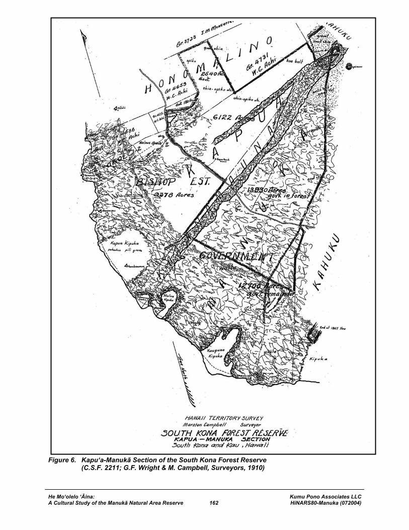
He Mo‘olelo ‘Āina: Kumu Pono Associates LLC A Cultural Study of the Manukā Natural Area Reserve 162 HiNARS80-Manuka (072004)
Figure 6. Kapu‘a-Manukā Section of the South Kona Forest Reserve (C.S.F. 2211; G.F. Wright & M. Campbell, Surveyors, 1910)
He Mo‘olelo ‘Āina: Kumu Pono Associates LLC A Cultural Study of the Manukā Natural Area Reserve 163 HiNARS80-Manuka (072004)
Survey Department of the Territory of Hawaii, which said maps are now on file in the said Survey Department marked Government Survey Registered Maps Nos. 2468 and 2469 and “Waiea-Kipahoehoe Forest Reserve” and “Kapua-Manuka Forest Reserve” respectively, and a description accompanying the same in three parts numbered C.S.F. 2211, 2245 and 2246, which said description now on file in the said Survey Department, is as follows: Kapua-Manuka Section. Including portions of the lands of Honomalino, Kapua, and Kaulanamauna, in South Kona, and portion of the lands of Manuka, in Kau, Island of Hawaii. C.S.F. 2211. Beginning at Government Survey Trig. Station “Puu o Ohohia” (marked by a large ahu) at the East corner of this reserve and at the common corners of the lands of Kaulanamauna and Manuka on the Kahuku boundary, from which station the true azimuth and distance to Government Survey Trig. Station “Puu o Keokeo” is 211º 52’ 08” 13078.1 feet , as shown on Government Survey Registered Map No. 2469, and running by true azimuths:
1. 28º 55’ 30” 6621.6 feet along the land of Kahuku to a + on set stone and ahu at Pohakuloa, a small rocky hill in large sand flat;
2. 16º 41’ 16705.0 feet along the land of Kahuku to Honopu, a small black rocky hill on aa flow;
3. 40º 33’ 11883.0 feet along the land of Kahuku to __[blank]__ on pahoehoe and ahu at Kahiawai on the lower side of the Government Road and on the south side of a gulch;
4. 345º 02’ 1528.0 feet along the land of Kahuku to a bottle placed in the center of Hitchcock’s old ahu at Puu Ainako, on the lower side of a gulch and just north of the Government Road;
5. 34º 30’ 5280.0 feet along the land of Kahuku to an unmarked point; 6. 17º 52’ 7000.0 feet along the land of Kahuku to an unmarked point; 7. 134º 29’ 24460.0 feet across the Government lands of Manuka and
Kaulanamauna to an unmarked point on the Kapua boundary; 8. 233º 20’ 20” 13000.0 feet along the land of Kapua to a + on set stone and ahu
on lower side of the Government Road at place called Uwe; 9. Thence along the upper side of the Government Road across the lands of Kapua
and Honomalino to an unmarked point, the direct azimuth and distance being: 158º 00’ 18000.0 feet;
10. 277º 20’ 5000.0 feet along Grant 4659 to W. C. Achi; 11. 221º 56’ 3104.0 feet along Grant 4659 to W. C. Achi; 12. 170º 05’ 8550.0 feet along Grant 4659 to W. C. Achi; 13. 260º 15’ 6375.0 feet along the land of Papa 2nd to ahu; 14. 350º 159’ 11750.0 feet along Grant 4731 to W. C. Achi, to ahu; 15. 250º 53’ 17165.0 feet along the land of Kapua to ahu on the Kahuku boundary; 16. 345º 39’ 2244.0 feet along the land of Kahuku to Hitchcock’s old ahu; 17. 1º 04’ 1711.0 feet along the land of Kahuku to ahu on the North edge of aa flow; 18. 263º 44’ 3676.0 feet along the land of Kahuku to the point of beginning.
Area 22,592 Acres.
He Mo‘olelo ‘Āina: Kumu Pono Associates LLC A Cultural Study of the Manukā Natural Area Reserve 164 HiNARS80-Manuka (072004)
And as provided by law, subject to the existing leases, I do hereby set apart as parts of the South Kona Forest Reserve those portions of the government lands known as Kaohe Tract (1555 acres), Kukuiopae Tract (2760 acres), Olelomoana-Opihihali Tract (3885 acres), Kipahoehoe (4590 acres), Honomalino (2540 acres), and Kaulanamauna (2060 acres) in the District of South Kona and Manuka (11,870 acres) in the District of Kau, altogether an area of 29,260 acres, more or less, that lie within the metes and bounds of the above described South Kona Forest Reserve. IN WITNESS WHEREOF, I have hereunto set my hand and caused the Great Seal of the Territory of Hawaii to be affixed. Done at the Capitol in Honolulu, this 17th day of May, A.D. 1911. W.F. FREAR Governor of Hawaii.
Subsequently, in 1929, one acre of land was withdrawn from the Kapu‘a-Manukā section of the South Kona Forest Reserve, for the Manuka Comfort Station. The station served as a base of operations for forestry field work. Over the years reports on the condition of the forest lands were submitted to the Board, and in a communication dated October 7, 1936, we learn that some, if not all of the lands in the South Kona Forest were being impacted by the intrusion of cattle.
October 7, 1936 Report on Hawaii Inspection Trip, by Territorial Forester (July-August 1936); to Board of Commissioners of Agriculture and Forestry:
…South Kona Forest Reserve Working out from the Manuka Ranger Station, where I spent the previous night, I made a 13 hour mule trip through very rough country to the upper lands in the South Kona reserve to ascertain the extent of cattle trespass. Going up the old road to the abandoned Yee Hop koa mill, I rode across and along the mauka boundary of this reserve at the general elevation of 5,000 feet on the Papa Trail crossing the government lands of Kipahoehoe, Olelomoana-Opihihali, Kukuiopae and Kaohe 1-3, coming down the Kaohe Ranch trail, one of the steepest and worst trails in the Territory. When this reserve was originally set aside, on the recommendation of my predecessor 25 years ago, there was an existing government lease on the Olelomoana-Opihihali tract of 3,885 acres. All of this land was not grazed; only the mauka section of about 1145 acres. This was fenced off so that the cattle could not wander down the slope and get lost or go wild in the dense jungle lower down the mountain. This lease expired in 1926 but cattle are still at large on this land and adjacent government lands within the forest reserve boundary. On the other government lands in forest reserve in this section which were never under lease, the upper portions have been and still are being grazed in conjunction with better grazing land leased from Kahuku Ranch just above the forest reserve further up the slopes of Mauna Loa. These grazing lands (mostly low ohia trees with a ground cover of amaumau fern) are separated from the heavy forest down the slope by a wire fence, now somewhat out of repair because of rotted posts. The logical location for the upper forest reserve boundary is this fence. The wire is still sound and all that is needed to make it stock proof is to replace the posts, timber for which is at hand… [Hawaii State Land Division Files]
In 1945, the Territorial Survey Department conducted a survey of the near-shore kīpuka (areas of older lava flows and vegetation, surrounded by newer lava flows), in Manukā and Kaulanamauna. Of
He Mo‘olelo ‘Āina: Kumu Pono Associates LLC A Cultural Study of the Manukā Natural Area Reserve 165 HiNARS80-Manuka (072004)
importance, these kīpuka represent areas of traditional residence, and are crossed by the ala hele (mauka-makai), and ala loa (lateral to the shore), which were used in ancient times (Figure 7).
C.S.F. 10,176 Kipukas in Kaulanamauna and Manuka Districts of South Kona and Kau Island of Hawaii Furnished Land Office July 18, 1945 KAULANAMAUNA KIPUKA – All of the land included within the Kipuka of this name situate within the land of Kaulanamauna, district of South Kona and the land of Manuka, district of Kau, island of Hawaii, as shown on sketch plan hereto attached and made a part hereof and containing an area of 110 acres, a little more or less; together with a right of way but not exclusive in the nature of an easement over and across the trail running from said Kipuka in a southeasterly and a northeasterly direction to the Government Main road, as shown on aforesaid sketch plan or over and across any trail hereinafter established by the Commissioner of Public Lands; reserving, however, a right of way in the nature of an easement of the trail over and across the said Kipuka as shown on said sketch plan or any modification thereof as may be established by the Commissioner of Public Lands. MALUA KIPUKA – All of the land included within the Kipuka of this name situate within the land of Manuka, district of Kau, island of Hawaii, as shown on sketch plan hereto attached and made a part thereof and containing an area of 216 acres, a little more or less; together with a right of way but not exclusive in the nature of an easement over and across the trail running from said Kipuka in a southeasterly and a northeasterly direction to the Government Main road, as shown on aforesaid sketch plan or over and across any trail hereinafter established by the Commissioner of Public Lands; reserving, however, a right of way in the nature of an easement of the trail over and across the said Kipuka as shown on said sketch plan or any modification thereof as may be established by the Commissioner of Public Lands. KAUPUAA KIPUKA – All of the land included within the Kipuka of this name situate within the land of Manuka, district of Kau, island of Hawaii, as shown on sketch plan hereto attached and made a part thereof and containing an area of 765 acres, a little more or less; together with a right of way but not exclusive in the nature of an easement over and across the trail running from said Kipuka in a southeasterly and a northeasterly direction to the Government Main road, as shown on aforesaid sketch plan or over and across any trail hereinafter established by the Commissioner of Public Lands; reserving, however, a right of way in the nature of an easement of the trail over and across the said Kipuka as shown on said sketch plan or any modification thereof as may be established by the Commissioner of Public Lands; and also a right of way from the Kauna Point Lighthouse Station to any existing trail or modification over and across this Kipuka. R.D. King Principal Cadastral Engineer [State Survey Division]
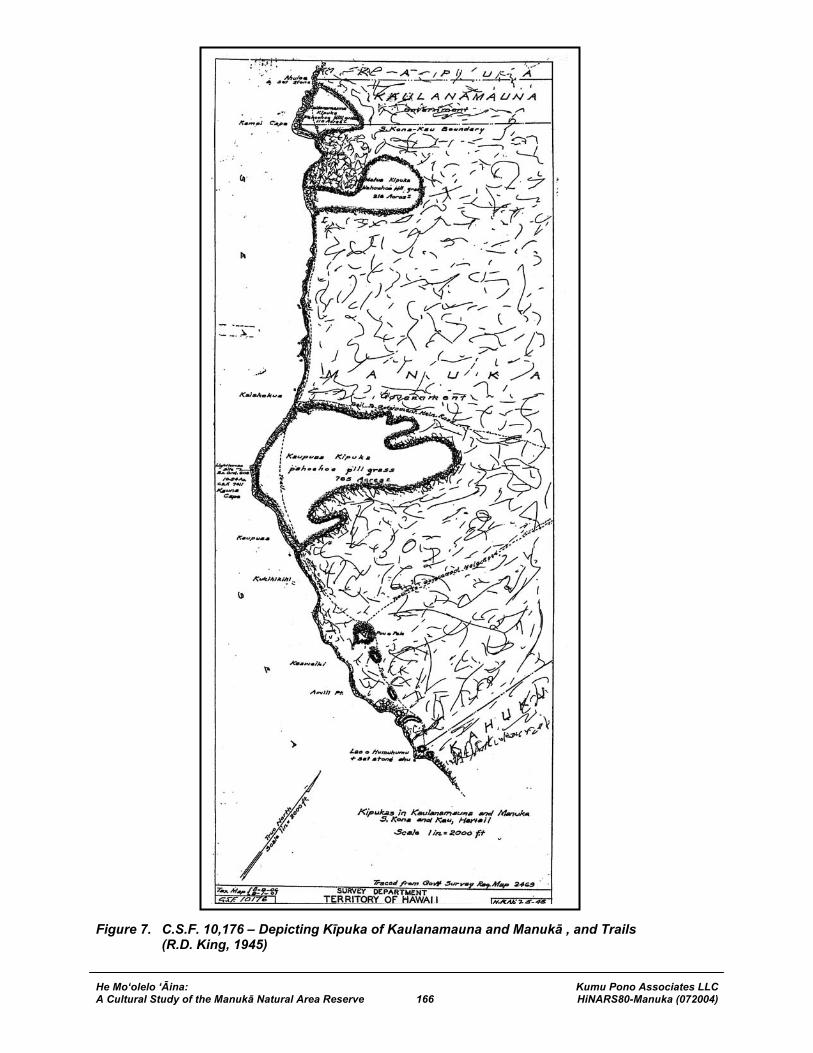
He Mo‘olelo ‘Āina: Kumu Pono Associates LLC A Cultural Study of the Manukā Natural Area Reserve 166 HiNARS80-Manuka (072004)
Figure 7. C.S.F. 10,176 – Depicting Kīpuka of Kaulanamauna and Manukā , and Trails (R.D. King, 1945)
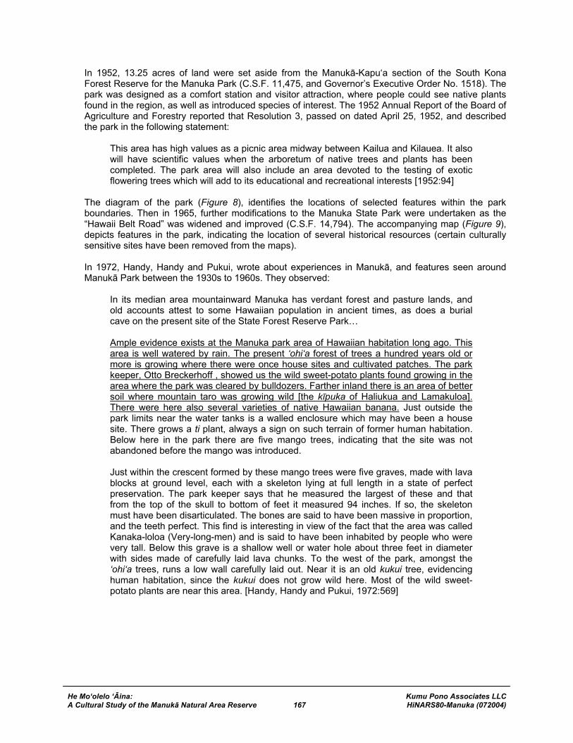
He Mo‘olelo ‘Āina: Kumu Pono Associates LLC A Cultural Study of the Manukā Natural Area Reserve 167 HiNARS80-Manuka (072004)
In 1952, 13.25 acres of land were set aside from the Manukā-Kapu‘a section of the South Kona Forest Reserve for the Manuka Park (C.S.F. 11,475, and Governor’s Executive Order No. 1518). The park was designed as a comfort station and visitor attraction, where people could see native plants found in the region, as well as introduced species of interest. The 1952 Annual Report of the Board of Agriculture and Forestry reported that Resolution 3, passed on dated April 25, 1952, and described the park in the following statement:
This area has high values as a picnic area midway between Kailua and Kilauea. It also will have scientific values when the arboretum of native trees and plants has been completed. The park area will also include an area devoted to the testing of exotic flowering trees which will add to its educational and recreational interests [1952:94]
The diagram of the park (Figure 8), identifies the locations of selected features within the park boundaries. Then in 1965, further modifications to the Manuka State Park were undertaken as the “Hawaii Belt Road” was widened and improved (C.S.F. 14,794). The accompanying map (Figure 9), depicts features in the park, indicating the location of several historical resources (certain culturally sensitive sites have been removed from the maps). In 1972, Handy, Handy and Pukui, wrote about experiences in Manukā, and features seen around Manukā Park between the 1930s to 1960s. They observed:
In its median area mountainward Manuka has verdant forest and pasture lands, and old accounts attest to some Hawaiian population in ancient times, as does a burial cave on the present site of the State Forest Reserve Park… Ample evidence exists at the Manuka park area of Hawaiian habitation long ago. This area is well watered by rain. The present ‘ohi‘a forest of trees a hundred years old or more is growing where there were once house sites and cultivated patches. The park keeper, Otto Breckerhoff , showed us the wild sweet-potato plants found growing in the area where the park was cleared by bulldozers. Farther inland there is an area of better soil where mountain taro was growing wild [the kīpuka of Haliukua and Lamakuloa]. There were here also several varieties of native Hawaiian banana. Just outside the park limits near the water tanks is a walled enclosure which may have been a house site. There grows a ti plant, always a sign on such terrain of former human habitation. Below here in the park there are five mango trees, indicating that the site was not abandoned before the mango was introduced. Just within the crescent formed by these mango trees were five graves, made with lava blocks at ground level, each with a skeleton lying at full length in a state of perfect preservation. The park keeper says that he measured the largest of these and that from the top of the skull to bottom of feet it measured 94 inches. If so, the skeleton must have been disarticulated. The bones are said to have been massive in proportion, and the teeth perfect. This find is interesting in view of the fact that the area was called Kanaka-loloa (Very-long-men) and is said to have been inhabited by people who were very tall. Below this grave is a shallow well or water hole about three feet in diameter with sides made of carefully laid lava chunks. To the west of the park, amongst the ‘ohi‘a trees, runs a low wall carefully laid out. Near it is an old kukui tree, evidencing human habitation, since the kukui does not grow wild here. Most of the wild sweet-potato plants are near this area. [Handy, Handy and Pukui, 1972:569]
He Mo‘olelo ‘Āina: Kumu Pono Associates LLC A Cultural Study of the Manukā Natural Area Reserve 168 HiNARS80-Manuka (072004)
Figure 8. Map of Manuka Park. C.S.F. 11,475 (May 21, 1952; not to Scale)
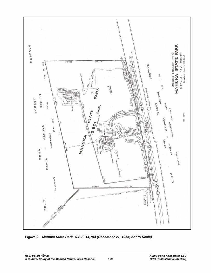
He Mo‘olelo ‘Āina: Kumu Pono Associates LLC A Cultural Study of the Manukā Natural Area Reserve 169 HiNARS80-Manuka (072004)
Figure 9. Manuka State Park. C.S.F. 14,794 (December 27, 1965; not to Scale)
He Mo‘olelo ‘Āina: Kumu Pono Associates LLC A Cultural Study of the Manukā Natural Area Reserve 170 HiNARS80-Manuka (072004)
MANUKA NATURAL AREA RESERVE The Manukā Natural Area Reserve is made up of lands that were originally set aside in 1911 as a part of the territorial government’s resource conservation program. In 1970, Hawai‘i became one of the first states in the country to designate unique natural resources as a part of a system of Natural Area Reserves. In accordance with State Law, the NARS are mandated to “preserve in perpetuity specific land and water areas which support communities, as relatively unmodified as possible, of the natural flora and fauna, as well as geological sites, of Hawaii” (HRS 195-1). In 1979, as a part of the ongoing program to designate unique natural systems as Natural Area Reserves, the lands of Manukā and Kaulanamauna were surveyed for withdrawal from the South Kona Forest Reserve as the formal, first step towards establishment of the Manukā NAR (cf. Gov’s. E.O. No. 3159). Those lands were described in C.S.F. 18,638, by the following notes of survey:
WITHDRAWAL PORTION OF SOUTH KONA FOREST RESERVE KAPUA-MANUKA SECTION (Governor’s Proclamation dated May 17, 1911) Manuka, Kau, Island of Hawaii, Hawaii For Tracing – See Plat 214 Withdrawn by Gov. Ex. Ord. 3159 (Dec. 20, 1982) (E.O. Folder 67-A) DLNR 7-18-79 (L.F. 186) C.S.F. 18,638 STATE OF HAWAII SURVEY DIVISION DEPT. OF ACCOUNTING AND GENERAL SERVICES HONOLULU May 4, 1979 WITHDRAWAL PORTION OF SOUTH KONA FOREST RESERVE KAPUA-MANUKA SECTION (Governor’s Proclamation dated May 17, 1911) Manuka, Kau, Island of Hawaii, Hawaii Being portion of the Government Land of Manuka. Beginning at the southwest corner of this parcel of land and on the boundary between the lands of Kahuku and Manuka, the coordinates of said point of beginning referred to Government Survey Triangulation Station “PUU O KAMAOA” being 5,537.29 feet South and 21,534.20 feet West, as shown on Government Survey Registered H.S.S. Plat 214, thence running by azimuths measured clockwise from True South:-
1. 134º 30’ 32” 22,214.00 feet along the remainder of the Government Land of Manuka;
2. 233º 01’ 02” 12,503.00 feet along the Government Land of Kaulanamauna, over and across Mamalahoa Highway to Government Survey Triangulation Station “KAHAHAWAI”;
He Mo‘olelo ‘Āina: Kumu Pono Associates LLC A Cultural Study of the Manukā Natural Area Reserve 171 HiNARS80-Manuka (072004)
3. 232º 29’ 42” 59.37 feet along the Government Land of Kaulanamauna and over and across the Old Government Road;
4. 232º 29’ 42” 420.26 feet along Parcel A of Highway Maintenance Baseyard (Governor’s Executive Order 2172);
5. 232º 29’ 42” 32,720.62 feet along the Government Land of Kaulanamauna; 6. 28º 57’ 02” 6621.60 feet along Grant 2791 to C.C. Harris to a “+” cut in rock on
hill called “Pohakuloa”; 7. 16º 42’ 32” 16,702.50 feet along Hawaiian Ocean View Estates, Unit 4 (File Plan
1011), along Grant 2791 to C.C. Harris to a “+” cut in rock on hill called “Honopu”; 8. 40º 32’ 50” 11,761.75 feet along Hawaiian Ocean View Estates, Unit 4 (File Plan
692), along Grant 2791 to C.C. Harris; 9. 40º 58’ 117.86 feet over and across Mamalahoa Highway and along Grant 2791
to C.C. Harris; 10. 344º 59’ 05” 1562.42 feet along Grant 2791 to C.C. Harris; 11. 34º 31’ 32” 5319.32 feet along Grant 2791 to C.C. Harris; 12. 17º 53’ 32” 7000.00 feet along Grant 2791 to C.C. Harris to the point of beginning
and containing an AREA OF 11,822.6 ACRES. SURVEY DIVISION DEPARTMENT OF ACCOUNTING AND GENERAL SERVICES STATE OF HAWAII By Ichiro Sakamoto Land Surveyor Compiled from R.M. 2468 & other Govt. Survey Records. [State Survey Division]
In 1982, the Manukā-Kaulanamauna lands withdrawn from the South Kona Forest reserve, where described in preparation for Governor’s Executive Order No. 3164, which would establish the Manukā Natural Area Reserve. The notes of survey provided the following description of the land area:
C.S.F. 19,618 MANUKA NATURAL AREA RESERVE Kaulanamauna, South Kona and Manuka, Kau, Island of Hawaii, Hawaii For Tracing see Plat 215-A [see Figure 10] Gov. Ex. Order 3164 dated Jan. 12, 1983 (E.O. Folder 3164) DLNR 10-22-82 (L.F. 186) STATE OF HAWAII SURVEY DIVISION DEPT. OF ACCOUNTING AND GENERAL SERVICES HONOLULU October 15, 1982
He Mo‘olelo ‘Āina: Kumu Pono Associates LLC A Cultural Study of the Manukā Natural Area Reserve 172 HiNARS80-Manuka (072004)
Figure 10. The Manukā Natural Area Reserve, Districts of Ka‘ū and South Kona, Island of Hawai‘i (Hawai‘i State Survey Plat Map No. 215-A; 1982)
He Mo‘olelo ‘Āina: Kumu Pono Associates LLC A Cultural Study of the Manukā Natural Area Reserve 173 HiNARS80-Manuka (072004)
MANUKA NATURAL AREA RESERVE Kaulanamauna, South Kona and Manuka, Kau, Island of Hawaii, Hawaii Being portions of the Government Lands of Kaulanamauna and Manuka. Beginning at the west corner of this parcel of land, on the northerly side of Jeep Trail and on the boundary between the lands of Kapua and Kaulanamauna, the coordinates of said point of beginning referred to Government Survey Triangulation Station “PUU O KAMAOA” being 2,785.75 feet North and 50,918.68 feet West, as shown on Government Survey Registered H.S.S. Plat 215-A, thence running by azimuths measured clockwise from True South:-
1. 233º 21’ 52” 27,894.00 feet along R.P. 6853, L.C.Aw. 9971, Ap. 30 to W.P. Leleiohoku to a concrete monument marked Kapua-Kaulanamauna;
2. 232º 56’ 32” 29,875.00 feet along R.P. 6853, L.C.Aw. 9971, Ap. 30 to W.P. Leleiohoku;
3. 263º 45’ 32” 3676.00 feet along Grant 2791 to C.C. Harris; 4. 28º 57’ 02” 6621.60 feet along Grant 2791 to C.C. Harris to a “+” cut in rock on
hill called “Pohakuloa”; 5. 16º 42’ 32” 16,702.50 feet along Hawaiian Ocean View Estates, Unit 4 (File Plan
1011), along Grant 2791 to C.C. Harris to a “+” cut in rock on hill called “Honopu”; 6. 40º 32’ 50” 11,761.75 feet along Hawaiian Ocean View Estates (File Plan 692),
along Grant 2791 to C.C. Harris; 7. 40º 58’ 117.86 feet over and across Mamalahoa Highway and along Grant 2791
to C.C. Harris; 8. 344º 59’ 05” 1562.42 feet along Grant 2791 to C.C. Harris; 9. 34º 31’ 32” 5319.32 feet along Grant 2791 to C.C. Harris; 10. 17º 53’ 32” 24,416.91 feet along Grant 2791 to C.C. Harris to a point 100.00 feet
north from the high-water mark at seashore; 11. Thence along Government Land, 100.00 feet north and parallel to the high-water
mark at seashore and along the northerly side of Jeep Trail, the direct azimuth and distance being: 136º 00’ 42” 34,604.91 feet to the point of beginning and containing a GROSS AREA OF 25,618.164 ACRES, MORE OR LESS and a NET AREA OF 25,550.000 ACRES, MORE OR LESS, after excluding and deducting there from Exclusions (68.164 ACRES) listed as follows:-
EXCLUSIONS:
1. Highway Maintenance Baseyard (Gov. Exec. Ord. 2172) 4.591 Acres 2. Grant 9818 to Hawaii Transportation Company, Ltd. 0.948 Acre 3. Manuka State Park 13.391 Acres 4. Mamalahoa Highway 33.234 Acres 5. Jeep Trails 16.0 Acres
TOTAL AREA OF EXCLUSIONS 68.164 Acres
He Mo‘olelo ‘Āina: Kumu Pono Associates LLC A Cultural Study of the Manukā Natural Area Reserve 174 HiNARS80-Manuka (072004)
SURVEY DIVISION DEPARTMENT OF ACCOUNTING AND GENERAL SERVICES STATE OF HAWAII By Robert T. Hashimoto Land Surveyor Compiled from data furn. By N.A.R.S., U.S.G.S. Map, R.M. 2468 and other Govt. Survey Records. [State Survey Division]
On January 12th, 1983, Governor George Ariyoshi, signed Executive Order No. 3164, establishing the Manukā NAR, comprised of lands from the ahupua‘a of Manuka and Kaulanamauna. The Executive Order, below, set the foundation for the long-term protection and conservation of the unique natural and cultural resources within the NAR lands:
Executive Order No. 3164 Setting Aside Land for Public Purposes January 12th, 1983 By this Executive Order, I, the undersigned, Governor of the State of Hawaii, by virtue of the authority in me vested by Section 171-11, Hawaii Revised Statutes, and every other authority me hereunto enabling, do hereby order that the public land hereinafter described be, and the same is, hereby set aside for the following public purposes: FOR NATURAL AREA RESERVE, to be under the control and management of the Department of Land and Natural Resources, State of Hawaii, being the lands situate at Kaulanamauna, South Kona and Manuka, Kau, Island of Hawaii, Hawaii, and designated as MANUKA NATURAL AREA RESERVE, containing a gross area of 25,618.164 Acres, more or less, and a net area of 25,550.000 Acres, more or less, after excluding and deducting there from exclusions of 68.164 Acres, all more particularly described in Exhibit “A” and delineated on Exhibit “B”, both of which are attached hereto and made a part hereof, said exhibits being, respectively, a survey description and survey map prepared by the Survey Division, Department of Accounting and General Services, State of Hawaii, both being designated as C.S.F. No. 19,618 and dated October 15, 1982. SUBJECT to disapproval by the Legislature by two-thirds vote of either the Senate or the House of Representatives or by majority vote of both, in any regular or special session next following the date of this Executive Order. In Witness Whereof, I have hereunto set my hand and caused the Great Seal of the State of Hawaii to be affixed. Done at the Capitol at Honolulu the 12th day of January, Nineteen Hundred and eighty three. George R. Ariyoshi Governor of the State of Hawaii [Natural Area Reserve Collection]
He Mo‘olelo ‘Āina: Kumu Pono Associates LLC A Cultural Study of the Manukā Natural Area Reserve 175 HiNARS80-Manuka (072004)
Overview of Resources and Management Objectives for the Manukā NAR In 1992, the Department of Land and Natural Resources, Natural Area Reserves System staff prepared a general management plan for the Manukā NAR. The following narratives taken from the 1992 plan, describe resources of the Manukā NAR and program objectives:
A. General Setting Manuka Natural Area Reserve occupies 25,550 acres on the southwest slope of Mauna Loa on the island of Hawaii... Elevations range from near sea level to 5,524 feet near Puu Ohohia at the reserve's apex. Rainfall averages from 30 inches annually in the lower elevation to 40 inches at the reserve's apex. Precipitation is probably higher along a band in the mid-elevations (ca. 1,800 - 3,200 feet) where daily cloud cover results in fog drip. March is the wettest month, averaging 3 - 4 inches, and June the driest with only 1 - 4 inches (Giambelluca, Nullet, and Schroeder 1986). Highway 11 runs through the center of the reserve at about 1,800 feet elevation. Along the highway in the center of the reserve, Manuka State Park encloses 13 acres and provides visitor facilities including a restroom, arboretum, and camping area. Manuka State Park and two other parcels along Highway 11 are excluded from the reserve. One parcel of 5 acres is used as a highway maintenance base yard and the other (less than one acre) is privately owned. The coastal area, two kipuka (Kaulanamauna and Kaupuaa), the mauka-makai jeep roads, and Kaheawai Trail are not included in the Natural Area Reserve, but are state lands. The reserve’s eastern boundary borders developing residential subdivisions (Oceanview Estates). A resort development project is also planned for the makai lands along the eastern boundary... The western boundary borders agricultural lands, a large portion of which are macadamia nut orchards. Above Highway 11, trails and roads provide access into the reserve from all sides. A loop trail from Manuka State Park extends up to 2200 feet in the central portion of the reserve. Trails from the Ocean View Estates subdivision lead into the reserve along the eastern boundary; a four-wheel drive road leads from the northern part of the subdivision onto Kahuku Ranch lands and across the reserve's apex. On the northwest boundary, Mac Farms of Hawaii has a road leading up from Highway 11. What appears to be an old, overgrown road and is now a foot trail, crosses into the center of the reserve along the 2,600 feet contour from Mac Farms road. Two rough four-wheel drive roads lead from Highway 11 to the coast. One road, known as Manuka Bay Road, begins close to the northwestern boundary and leads down to Manuka Bay. The other road crosses private lands just east of the reserve, and becomes the reserve's eastern boundary from 700 feet elevation to Humuhumu Point. A coastal jeep road begins at Manuka Bay and extends just past Kipuka Kaupuaa. These roads are frequently used by fisherman and campers. Kaheawai Trail begins at Highway 11 near the eastern border and extends to the coast at Kipuka Kaupuaa. Though shown on maps as a four-wheel drive road, it is overgrown and only useable as a foot trail.
B. Flora and Fauna Eighteen natural communities were observed in the reserve during the 1989 survey.. Of these, four non-vegetated aquatic and subterranean communities were seen: two kinds of anchialine pools (one rare) and two kinds of uncharacterized lava tubes. The fourteen vegetated communities ranged from coastal dry shrublands to subalpine forest including the rare Koa/‘Ohi‘a Montane Mesic Forest and Pili Lowland Dry Grassland communities.
He Mo‘olelo ‘Āina: Kumu Pono Associates LLC A Cultural Study of the Manukā Natural Area Reserve 176 HiNARS80-Manuka (072004)
Of the seven rare plants confirmed within the reserve boundaries, 3 were observed during the 1989 field survey… Four common native birds were seen during the 1989 survey of Manuka reserve. ‘Amakihi (Hemignathus virens), ‘apapane (Himatione sanguinea), ‘elepaio (Chasiempis sandwichensis), and ‘i‘iwi (Vestiaria coccinea). Two rare birds, the ‘io, or Hawaiian hawk (Buteo solitarius), and the ‘alala, or Hawaiian crow (Corbus hawaiiensis), and the rare ‘ope‘ape‘a, or Hawaiian hoary bat (Lasiurus cinereus semotus) are known from the reserve... Of these only the ‘io was seen during the 1989 survey.
Non-native birds commonly seen in the reserve during the 1989 survey included Japanese white-eye (Zosterops japonicus), northern cardinal (Cardinalis cardinalis), zebra dove, (Geopelia striata), spotted dove (Streptopelia chinensis), Japanese bush-warbler (Cettia diphone), kalij pheasant (Lophura leucomelana) and common mynah (Acridotheres tristis). A high diversity of native invertebrates including anchialine pool shrimp, crickets, spiders, flies, bees, wasps, planthoppers, and antlions (Eidoleon wilsoni) were seen during the 1989 survey. Non-native invertebrates present in the reserve included mosquitoes, ants and yellow jackets (Vespula sp.), which are species of management concern because of their effects on native invertebrates.
A. Key Management Considerations The overall management goal is to protect, maintain, and enhance the reserve's native ecosystems. The following key points were considered in the development of management programs to achieve this goal:
1) Since the Manuka reserve is very large, intensive management of the entire
reserve is not realistic at this time. Management priorities for specific areas are based on biological resources, the extent of current disturbances, the nature of biological threats within and near the area, and the feasibility of management.
2) Invasive nonnative plants and feral animals constitute a severe threat to the reserve's native vegetation. Invasive nonnative plants threaten the integrity of the reserve's natural communities by competing with native plants for space, light, and nutrients and facilitating the invasion of nonnative insects and birds.
Feral animals destroy native plants, distribute nonnative plant seeds, and create openings in the native ground cover. These openings contribute to soil erosion and facilitate the establishment of nonnative plants. Control of invasive weeds and feral animals will be necessary to preserve the integrity of the natural communities.
3) Marijuana cultivation in the reserve is a major problem. Clearings created by cultivators damage native plants and facilitate nonnative plant invasion. Cultivators protecting their plantings can jeopardize the safety of legitimate reserve users. Native hardwood removal is another problem in the reserve. The stump of a rare kauila (Colubrina oppositifolia) tree, one of less than fifty known in the reserve, was seen during the 1989 survey near Manuka Bay Road.
4) A number of archaeological sites are present in the reserve including burial caves and petroglyphs in the coastal area, and farming terraces in the forested area. The Kaheawai Trail below Highway 11 is an old Hawaiian foot trail which passes by rock carvings. These sites should be maintained and used as educational resources. Additional archaeological surveys and research are
He Mo‘olelo ‘Āina: Kumu Pono Associates LLC A Cultural Study of the Manukā Natural Area Reserve 177 HiNARS80-Manuka (072004)
needed throughout the reserve. The Hawaii Island Burial Council should be consulted regarding the management of any burial caves in the reserve.
B. Management Units The reserve has been divided into five management units…:
1) Kipuka Unit - this 600-acre unit extends from the top of the reserve down to 4600 feet elevation. Pioneer vegetation on lava flows surrounds several kipukas which contain Koa/‘Ohi‘a Montane Mesic Forest, ‘Ohi‘a Subalpine Dry Forest, and Pukiawe Subalpine Dry Shrubland communities. Some old light pig and goat damage and only a few nonnative plants were present in the kipuka communities.
2) Upper Pioneer Unit - this 2300-acre unit extends from 4600 feet down to 3200 feet and contains primarily pioneer vegetation on lava flows, though portions of the ‘Ohi‘a Montane Mesic Forest community are also present along the lower and western boundaries. The communities in this unit were not surveyed for ungulate damage or weed infestation.
3) ‘Ohi‘a Unit - this 5100-acre unit extends from 3200 feet down to Highway 11. ‘Ohi‘a Lowland and Montane Mesic Forest, and Pioneer Vegetation on Lava Flow communities are found in this unit. Several rare plants and animals including the ‘alala have been reported in this unit. This unit contained widespread pig damage; several nonnative plants were present in the lower elevations which have a great potential for spreading.
4) Lowland Unit - this 7900-acre unit extends from Highway 11 down to the 600 foot contour interval. Mesic and Dry Lowland ‘Ohi‘a and Lama Forest communities, and patches of ‘A‘ali‘i Lowland Dry Shrubland and Nonnative Dominated communities are present. In this unit, there was light pig damage in the upper forested regions; nonnative plant infestation was widespread.
5) Lower Pioneer Unit - this 9600-acre unit extends from 600 feet elevation down to the coastal boundary. Pioneer vegetation on lava flows dominates, while patches of Ilima Coastal Dry Shrubland, Pili Lowland Dry Grassland, Nonnative Dominated communities, and anchialine pools and lava tubes are also present. Light goat damage was found in the coastal regions.
C. Management Programs The following four management programs outline the long-term goals for the reserve. A six-year implementation schedule is proposed. The four programs form an integrated management package. 1. NONNATIVE SPECIES CONTROL a. Feral Ungulate Control
GOAL: Reduce ungulate populations to the lowest possible level in areas of the reserve dominated by native species.
Statement of the Problem: Feral pigs and goats are a serious concern in the Manuka Natural Area Reserve. Figure 5 shows the degree of ungulate damage encountered along the transects in the 1989 survey. Pig damage was most abundant in the mesic ‘ohi‘a forests of the Ohia management unit, particularly near the northwestern boundary between the reserve and macadamia nut orchards. Goat sign was found in the uppermost and coastal regions of the reserve. Left unchecked, ungulate populations will continue to degrade the native
He Mo‘olelo ‘Āina: Kumu Pono Associates LLC A Cultural Study of the Manukā Natural Area Reserve 178 HiNARS80-Manuka (072004)
ecosystems for which the reserve was established. Public hunting is well established in the reserve. The Ohia, Upper Pioneer, and
Kipuka management units are within Public Hunting Unit B which allows year round hunting with dogs.
The Lowland and Lower Pioneer management units are within Public Hunting Unit C which allows hunting only from June to August without dogs.
The reserve is very large, but accessible along all of its boundaries. In the densely vegetated Ohia unit where pigs are widespread and existing trail access is limited, access improvement may help to direct and distribute hunting pressure.
Consideration of Alternative Actions:
1) Control ungulates using public hunting pressure. Though, public hunting can be a viable tool for ungulate control in the early stages of a removal program, public hunting alone is not effective in reducing ungulate populations to the levels necessary to prevent further degradation of the natural communities. Increased hunter presence in the reserve could provide additional corridors contributing to nonnative animal and plant invasion.
2) Control ungulates using trained staff hunters. Staff hunters may include volunteer or paid hunters appointed as agents of the state. Trained hunters using dogs in a systematic hunting program could lower ungulate populations to remnant levels. However, increased hunter presence in the reserve could provide additional corridors for nonnative animal and plant invasion.
3) Control ungulates with fencing. Fencing will prevent the movement of ungulates into certain areas and direct predictable ungulate movements within intensive control areas. However, fencing is expensive to build and maintain, and may not be necessary to adequately control ungulate damage in all areas of the reserve.
4) Control pigs using snares. Snaring is an effective control technique, especially in fenced areas which channel pig movements. However, snaring is not compatible with intensive public use or hunting with dogs.
Recommended Action: Initially alternatives 1, 2, and 3 are recommended. Fencing is recommended along the northwest boundary of the Lowland and ‘Ohi‘a management unit and will be considered around the upper Kipuka management unit. Ungulate removal will consist of public hunting supplemented by staff hunting with priority given to the ‘Ohi‘a, Lowland, and Kipuka management units. Access improvement is proposed in the Ohia management unit to facilitate ungulate control activities. Three projects, fence construction and maintenance, ungulate removal, and access improvement are described below. Close monitoring will be essential to determine hunting effectiveness (See Monitoring program). Other alternatives such as snaring in remote areas or areas closed to public hunting, and additional fencing may need to be reconsidered if monitoring indicates continued or increased ungulate damage. Project 1 - Fence construction and maintenance. Fence lines are planned along the northwestern boundary of the Lowland and ‘Ohi‘a management units to prevent pig migration between the reserve and the adjacent macadamia nut orchards… Fencing around the Kipuka management unit may also be necessary, as the rare Koa/‘Ohi‘a
He Mo‘olelo ‘Āina: Kumu Pono Associates LLC A Cultural Study of the Manukā Natural Area Reserve 179 HiNARS80-Manuka (072004)
Montane Mesic Forest community is present in some of the kipukas. The fences will consist of 47 inch high galvanized woven wire supplemented along the ground surface by one strand of barbed wire. Woven wire and barbed wire will be secured to steel posts placed no more than 10 feet apart. Concreted galvanized pipes will be used to secure the fence line at certain corners. Fence line locations will be carefully cleared to minimize disturbance to existing vegetation. A botanist will walk the flagged fence route to search for rare plants to be avoided during the clearing of the fence line. Strict sanitary procedures will be followed by field personnel to prevent introduction of weeds on their boots, clothing, and equipment… Project 2 - Ungulate removal. Both public and staff hunting are recommended to control pig and goat populations in the reserve. In the Lower Pioneer and Lowland management units, public hunting restrictions currently in place should be relaxed to allow year round hunting with dogs and no bag limits. Special hunts could be used to increase public hunting pressure. All public hunters should be obligated to report data on health, sex, and age of ungulates captured to NARS staff. Data accumulated during control activities will be compiled and analyzed with other monitoring data to determine program effectiveness. Staff hunting should focus initially on the more remote regions of the reserve where public hunters are less likely to visit, such as the upper kipukas. Aerial hunting may be necessary to control regional goat populations. The frequency of staff hunting expeditions should be adjusted according to hunting success and monitoring indicators. To the extent possible, ground staff hunting should be carried out by volunteer hunters who have their own hunting dogs. Volunteer hunters should receive training and logistical support to assist staff in intensive ungulate removal efforts… Project 3 - Access improvement. A 5.25 mile central loop trail branching off of the existing loop trail from Manuka State Park is planned for the ‘Ohi‘a management unit... This should help to direct and distribute hunting pressure in the central and upper portions of this unit. The proposed trail would be primarily used by hunters and management personnel, but could also be used by hikers. Prior to trail clearing an archaeological and a botanical survey should be carried out along the proposed route. Both the Manuka Loop Trail and the Kaheawai Trail, as well as Manuka Bay Road will also be maintained. Strict sanitary procedures will be followed by management personnel to prevent introduction of weeds on their boots, clothing, and equipment… b. Nonnative Plant Control
GOAL: To limit the spread and, where possible, eradicate invasive nonnative plant infestations.
Statement of the Problem: There are many nonnative plants present throughout the reserve. Figure 5 shows the distribution of some of the priority weeds encountered along the transects sampled during the 1989 survey.
Nonnative plants were widespread in the Lowland and Lower Pioneer management units. Some areas were dominated by nonnative species such as kukui (Aleurites moluccana), Christmas berry (Schinus terebinthifolius), guava (Psidium guajava), Lantana camara, natal redtop (Rhynchelytrum repens), molasses grass (Melinis minutiflora), kiawe (Prosopis pallida), koa haole (Leucaena leucocephala), and fountain grass (Pennisetum setaceum)...
He Mo‘olelo ‘Āina: Kumu Pono Associates LLC A Cultural Study of the Manukā Natural Area Reserve 180 HiNARS80-Manuka (072004)
Grasses such as fountain grass and broomsedge are known to increase fuel loads and fire frequency. Fountain grass was only found in the coastal area. Broomsedge was found in the lowland ‘ohi‘a forest on the southern side of the reserve. Control of fountain grass and broomsedge especially in areas in close proximity to high quality native dominated communities will help reduce the risk of fire damage or destruction (See Fire Control program).
Common weeds in the Lama and ‘Ohi‘a Lowland Dry Forests of the Lowland management unit included Christmas berry, honohono kukui (Oplismenus hirtellus), Jamaican verbain (Stachytarpheta jamaicensis), Lantana camara, laua‘e (Phymatosorus scolopendria), and guava.
In the ‘Ohi‘a management unit, several weeds were common. Weed infestation was heaviest in the lower elevations. Some of the more prominent weeds in the ‘Ohi‘a Lowland Mesic Forest included pamakani, Desmodium sp., Hilo grass (Paspalum conjugatum), sweet granadilla (Passiflora ligularis), guava, and thimbleberry (Rubus rosifolius). A localized infestation of shampoo ginger (Zingiber zerumbet) was present. A few trees planted at the Manuka State Park arboretum appeared to be spreading into the reserve including trumpet tree (Cecropia peltata).
In the ‘Ohi‘a Montane Mesic Forest, weeds were not as common but include pamakani, dogtail (Buddleia asiatica), Hilo grass, sweet granadilla, Phaius tankervilliae, and Youngia japonica. A localized infestation of banana poka (Passiflora mollissima) was present.
The communities in the Upper Pioneer management unit were not surveyed for weed infestation.
In the Kipuka management unit, weeds were infrequent. The most prominent weed in the Koa/‘Ohi‘a Montane Mesic Forest and ‘Ohi‘a Subalpine Dry Forest kipuka communities was meadow ricegrass (Ehrharta stipoides). Weeds were generally sparse on the pioneer vegetation on lava flows communities throughout the reserve. However, some weeds such as broomsedge (Andropogon virginicus), Pluchea symphytifolia, and pamakani were present.
Consideration of Alternative Actions:
1) Attempt to control all nonnative plant species in the reserve. This alternative would require substantial resources and is not practical.
2) Control and eradicate priority weeds in the intact communities of the reserve. In the rest of the reserve, control priority weeds as necessary to prevent their expansion in the reserve.
Recommended Action: Alternative #2 is recommended. Nonnative plant removal will be undertaken regularly during monitoring surveys, and along fence lines, jeep roads, and trails. Localized populations of invasive weeds such as banana poka and shampoo ginger will be located and removed immediately before they spread. Nonnative dominated areas and large infestations of weeds such as fountain grass and guava will be monitored and controlled to prevent their further spread. Strict sanitary procedures will be followed to prevent introduction of weeds by management personnel on their boots, clothing, and equipment. The use of manual and chemical weed control methods will be determined by the type of weed, the value and accessibility of the area it is invading, and the effectiveness of the control measure. Bio-control is an important potential tool in the management of widespread nonnative
He Mo‘olelo ‘Āina: Kumu Pono Associates LLC A Cultural Study of the Manukā Natural Area Reserve 181 HiNARS80-Manuka (072004)
plant infestations. The Natural Area Reserves System program will continue to support interagency bio-control projects. Detailed records of the effectiveness of control measures used in the reserve will be kept. Communication with the National Park Service and other agencies involved in plant control work will ensure that the best available control techniques are utilized… c. Other Nonnative Species
GOAL: To reduce the impact of other types of nonnative species (including mosquitoes, ants, yellow jackets, and fish) which could threaten the integrity of the native ecosystems within the reserve.
Statement of the Problem: Several nonnative invertebrates (mosquitoes, ants, yellow jackets (Vespula sp.)) were encountered during the 1989 survey that are of management concern. Mosquitoes are known to carry avian malaria, which has contributed to the decline of native forest bird populations (Van Riper et al. 1982). Ants are known to prey upon endemic invertebrates including native pollinators (Reimer 1990). Yellow jackets are of similar concern as they prey upon endemic invertebrates, some of which may be native pollinators (Beardsley 1980).
Little information is available regarding the status of these problem invertebrates in the reserve. Dr. Neil Reimer has received a research grant from the Natural Area Reserves System Program to conduct a baseline survey of the ant fauna of all of the Natural Area Reserves. However, additional research is needed in order to determine the magnitude of the threat posed by these species, and recommend strategies for their control. Van Riper (1982) recommended limiting mosquito breeding sites by controlling feral pigs, which create wallows which eventually fill with water and become mosquito breeding sites; as well as actively pursuing removal of other sources of stagnant water within the vicinity of the reserve.
Also, nonnative fish were observed in the anchialine pond communities during the 1989 survey. Both native and nonnative fish are of management concern due to their effects on native invertebrates. Maciolek and Brock (1974) associated both nonnative and native fish presence with diminished populations of the shrimp ‘opae‘ula (Halocaridina rubra). Additional surveys are needed to document the resources of the anchialine ponds and determine the threat posed by native and nonnative fish.
Recommended Action: Encourage and where possible provide financial support for research into the status of potentially problematic nonnative species, and actively pursue management recommendations resulting from this research. The feral ungulate control program discussed above should help to reduce the breeding sites for mosquitoes. Removal of other stagnant water sources within the area should also be actively sought. Any Vespula nests found during management activities should be removed…
2. MONITORING AND RESEARCH GOAL: To monitor the state of the biological, cultural, and physical resources of the reserve; gauge the effectiveness of management projects; and promote research to guide management programs. Statement of the Problem: The management programs discussed above were developed using only limited information from preliminary surveys. Additional research
He Mo‘olelo ‘Āina: Kumu Pono Associates LLC A Cultural Study of the Manukā Natural Area Reserve 182 HiNARS80-Manuka (072004)
and survey work are needed to identify resources within the reserve, i.e. for the anchialine pond and lava tube communities, and well as invertebrate fauna. Monitoring and research will be necessary to determine the effectiveness of the management programs and identify additional management needs. Systematic monitoring at specific locations is necessary to accurately assess changes in the abundance and distribution of native and nonnative plants and animals. Lack of a monitoring program could result in inefficient management due to poor understanding of the area's biological needs. Recommended Action: Establish a systematic monitoring program and increase monitoring intensity for select problems and areas as needed. Continue to encourage and foster management related research throughout the Natural Area Reserves System by providing logistical support and financial assistant in the form of annual research grants. Monitoring activities will entail recording specific data at permanent points and transects in the reserve. A minimum crew of two people will be necessary for transect surveys. An annual reconnaissance over flight is also recommended. Immediate goals of the monitoring program are to determine: 1) the effectiveness of hunting activities in reducing ungulate damage, 2) the success of weed control activities, 3) the presence of new nonnative plant infestations, and 4) the status of native vegetation… 3. FIRE CONTROL Goal: Prevent all wildfires in the reserve. Statement of the Problem: Fire is a potential problem in this reserve. Dry to mesic conditions prevail throughout the reserve. High risk areas for fire ignition are Highway 11, which bisects the middle of the reserve; Manuka State Park, which provides camping facilities; and the Lower Pioneer management unit which contains fountain grass and below which campers often frequent the coastal areas. Fountain grass and broomsedge in the Lower Pioneer management unit are a problem as they provide easily combustible fuel and resprout and increase their domain after successive fires. Recommended Action: Establish a fire management plan for the reserve which will include the mapping of priority areas. Ensure NARS personnel are adequately trained for fire control. Establish contacts with other fire fighting agencies who could provide manpower and equipment in the event of a fire in Manuka. Control and if possible eradicate fountain grass and broomsedge infestations especially in areas in close proximity to high quality native dominated communities. Post signs in Manuka State Park and in the frequently used camping areas along the coast to warn of high fire risk. Minimum impact methods of suppression should be applied whenever such methods are sufficient. Bulldozers could be used along all existing roads; however, bulldozing and other extreme fire control measures would not be justified within the reserve unless a fire cannot be otherwise controlled and the bulldozing damage is outweighed by a probable greater loss of natural and archaeological resources (NARS 1990). A fire cache should be established near the reserve at Kiolakaa cabin… [DLNR-NARS, 1992]
This study has been undertaken to provide resource managers and the public with important background information, documenting the wide range of cultural values, practices, and knowledge of resources of lands within and adjoining the Manukā Natural Area Reserve. An understanding of the cultural environment will help resource managers and the public ensure that the unique Hawaiian qualities of the Manukā NAR, remain a healthy and resilient part of the cultural landscape through future generations.
He Mo‘olelo ‘Āina: Kumu Pono Associates LLC A Cultural Study of the Manukā Natural Area Reserve 183 HiNARS80-Manuka (072004)
REFERENCES CITED ACHP (Advisory Council on Historic Preservation)
1985 Guidelines for Consideration of Traditional Cultural Values in Historic Preservation Review. Washington, D.C.: Advisory Council on Historic Preservation. (Draft report, August)
Alexander, W.D.
1891 A Brief History of Land Titles in the Hawaiian Kingdom. Hawaiian Almanac and Annual for 1891. Honolulu. T.G. Thrum.
Beardsley, John
1980 Haleakala National Park Crater District Resources Basic Inventory: Insects. Technical Report 31, Cooperative National Park Resources Studies Unit, University of Hawaii at Manoa, Department of Botany, Honolulu, Hawaii.
Beckwith, M.
1970 Hawaiian Mythology. Honolulu: University of Hawaii Press.
Boundary Commission Testimony 1873-1910 Hawaii State Archives (Digitized copy in collection of Kumu Pono Associates LLC).
Bowser, G. (compiler) 1880 The Hawaiian Kingdom Statistical and Commercial Directory and Tourists Guide.
Honolulu: Bowser and Co.
DLNR-NARS 1992 Manuka Natural Area Reserve Management Plan. Division of Forestry and Wildlife
Department of Land and Natural Resources, State of Hawaii. (January 1992)
Ellis, W. 1963 Journal of William Ellis. Honolulu: Advertiser Publishing Co., Ltd.
Fornander, A. 1917- Fornander Collection of Hawaiian Antiquities and Folklore. (9 vols.). Honolulu: 1919 Bishop Museum Press. l973 An Account of the Polynesian Race: Its Origin and Migrations. Tokyo: Charles E.
Tuttle Co., Inc.
Giambelluca, T. W., M. A. Nullet, and T. A. Schroeder 1986 Rainfall Atlas of Hawaii. Water Resources Research Center/Department of
Meteorology, University of Hawaii at Manoa. State of Hawaii, DLNR, Division of Water and Land Development, Report R76. Honolulu, Hawaii.
Ii, J.P.
l959 Fragments of Hawaiian History. Honolulu: Bishop Museum Press.
Kamakau, S.M. 1961 Ruling Chiefs of Hawaii. Honolulu: Kamehameha Schools Press.
Kingdom of Hawai‘i 1850 Kanawai Hoopai Karaima no ko Hawaii Pae Aina [Penal Code].
He Mo‘olelo ‘Āina: Kumu Pono Associates LLC A Cultural Study of the Manukā Natural Area Reserve 184 HiNARS80-Manuka (072004)
Lyons, C.J. 1875 Land Matters in Hawaii. Islander, Honolulu.
Malo, D. 1951 Hawaiian Antiquities. Honolulu, B.P. Bishop Museum.
Maly, Kepā (translator) ms. Ka‘ao Ho‘oniua Pu‘uwai no Ka-Miki (The Heart Stirring Story of Ka-Miki). Published in
the Hawaiian Newspaper, Ka Hoku o Hawaii; January 8, 1914 - December 6, 1917, by John Wise and J.W.H.I. Kihe, et al.
Maciolek, John A. and Richard E. Brock
1974 Aquatic Survey of the Kona Coast Ponds, Hawaii Island. Sea Grant Advisory Report UNIHI-SEAGRANT-AR-74-04: Honolulu, 73 pp. (April 1974)
Natural Area Reserves System
1990 Fire Control Policy: Natural Area Reserves System and the Waimanu National Estuarine Research Reserve. Natural Area Reserves System Commission, Department of Land and Natural Resources, State of Hawaii. Honolulu, Hawaii.
Natural Area Reserves System
1992 Manuka Natural Area Reserve Inventory Report, April 1989. Division of Forestry and Wildlife, Department of Land and Natural Resources, State of Hawaii. Honolulu, Hawaii. (January 1992)
OEQC (Office of Environmental Quality Control, State of Hawai‘i)
1997 Guidelines for Assessing Cultural Impacts. Adopted by the Environmental Council; November 17, 1997.
Parker, P.L., and T.F. King
1990 Guidelines for Evaluating and Documenting Traditional Cultural Properties. National Register Bulletin 38. U.S. Department of the Interior, National Park Service, Washington D.C.
Pukui, M.K., and A.L. Korn
1973 The Echo of Our Song. Chants and Poems of the Hawaiians. Honolulu: University Press of Hawaii.
Reimer, Neil.
1990 A Baseline Survey of the Ant Fauna of the Hawaii Natural Area Reserves System. A Research Grant Proposal for FY 90 and 91 submitted to the Natural Area Reserves System Commission. Unpublished.
State of Hawai‘i
Ms. Files cited in text from the collections of the: Bureau of Conveyances Division of Forestry and Wildlife (Hilo) Hawai‘i State Archives Land Division Natural Area Reserves System Office (Honolulu) State Survey Division
Stokes, J.F.G., and T. Dye 1991 Heiau of the Island of Hawai‘i. Bishop Museum Bulletin in Anthropology 2. Bishop
Museum Press, Honolulu.
He Mo‘olelo ‘Āina: Kumu Pono Associates LLC A Cultural Study of the Manukā Natural Area Reserve 185 HiNARS80-Manuka (072004)
Tatar, E.
1982 Nineteenth Century Hawaiian Chant. Pacific Anthropological Records No. 33. Department of Anthropology, B.P. Bishop Museum, Honolulu.
Van Riper, Charles III, Sandra G. van Riper, M. Lee Goff, and Marshall Laird.
1982 The Impact of Malaria on Birds in Hawaii Volcanoes National Park. Technical Report 47, Cooperative National Park Resources Studies Unit, University of Hawaii at Manoa, Department of Botany, Honolulu, Hawaii.
Wilkes, C.
1970 Narrative of the United States Exploring Expedition During the Years 1838-1842, Under the Command of C. Wilkes, U.S.N. Vol. 4. Philadelphia: Loa and Blanchard. (original date of publication, 1845)