Embed Size (px)
Citation preview


Groundwater Research and Management:Integrating Science into Management Decisions

Groundwater Governance in Asia Series
Groundwater Research and Management:Integrating Science into Management Decisions
Proceedings of IWMI- ITP- NIH International Workshop on“Creating Synergy between Groundwater Researchand Management in South and Southeast Asia”
8-9 February 2005, Roorkee, India
Edited by
Bharat R. SharmaInternational Water Management Institute (IWMI),New Delhi, India
Karen G. VillholthInternational Water Management Institute (IWMI),Sri Lanka, Colombo
Kapil D. SharmaNational Institute of Hydrology (NIH),Roorkee, India
International Water Management Institutein association with theNational Institute of Hydrologyand theIWMI – TATA Water Policy Program

International Water Management Institute
Headquarters Asia Regional OfficeP O Box 2075 CG Block, NASC ComplexColombo Dev Prakash Shastri MargSri Lanka Pusa, New Delhi-110 012www.iwmi.cgiar.org India
The editors: Bharat R Sharma is Senior Researcher/ Liaison Officer at South AsiaRegional Office and Karen G Villholth is Ground Water Management Specialist atthe Global Research Unit, Colombo both of the International Water ManagementInstitute. Kapil D Sharma is Director of the National Institute of Hydrology,Roorkee, India.
Citation: Sharma, B. R.; Villholth, K. G.; Sharma, K. D. (Eds.). 2006. Groundwaterresearch and management: Integrating science into management decisions.Proceedings of IWMI-ITP-NIH International Workshop on “Creating SynergyBetween Groundwater Research and Management in South and Southeast Asia”,Roorkee, India. 8-9 February 2005. Colombo, Sri Lanka: International WaterManagement Institute. 282p. (Groundwater Governance in Asia Series - 1)
Groundwater management / groundwater development / decision making /water harvesting / groundwater irrigation / simulation models / poverty /domestic water / institutions / policy / runoff / legal aspects / governance / soilsalinity / waterlogging / aquifers / tube wells / artificial recharge / watershedmanagement / water quality / India / Pakistan / Bangladesh / Nepal / China /Syria
ISBN: 92-9090- 647-2978-92- 9090- 647-6
Cover page: Groundwater Management Research Alliance (Concept: Karen GVillhoth)
Copyright © 2006, IWMI. All rights reserved.
Printed and bound in India by Malhotra Publishing House, New Delhi- 110 015,E-mail: [email protected] from the copy supplied by the editors.

Contents
Contributors
Preface
Acknowledgements
1. Creating Synergy between Groundwater Research and Management 1in South and South East AsiaKaren G. Villholth and Bharat R. Sharma
2. Groundwater and Human Development: Challenges and 14Opportunities in Livelihoods and EnvironmentTushaar Shah
Country Papers
I. Bangladesh
3. Groundwater Resources Development in Bangladesh: 27Contribution to Irrigation for Food Security and Constraintsto SustainabilityAnwar Zahid and Syed Reaz Uddin Ahmed
II. China
4. Availability, Status of Development, and Constraints for 47Sustainable Exploitation of Groundwater in ChinaMenggui Jin, Xing Liang, Yinglan Cao and Renquan Zhang
III. India
5. Status of Groundwater and Policy Issues for its Sustainable 62Development in IndiaMahender Mehta
6. National Blueprint for Recharging Groundwater Resources of India 75Saleem Romani
7. Central Groundwater Authority- Past Experience and Future 87Strategies for Regulating the Development and Utilization ofGroundwater in IndiaSaleem Romani

Contentsvi
IV. Nepal
8. Understanding Groundwater for Proper Utilization and 95Management in NepalDibya Ratna Kansakar
V. Pakistan
9. Prospectives and Limits of Groundwater Use in Pakistan 105Muhammad Nawaz Bhutta and Muhammad Mehboob Alam
Groundwater Issues
10. Groundwater Models: How the Science Can Empower the 115Management?N.C. Ghosh and Kapil D. Sharma
11. Watershed Management and Water Harvesting as Strategic 134Tools for Groundwater AugmentationV.N. Sharda
12. Simulation Modeling and Optimization Studies for the 147Groundwater Basins of Northwest India: Case Studies andPolicy ImplicationsS.K. Sondhi and M.P. Kaushal
13. Application of Hydraulic and Economic Optimization for 169Planning Conjunctive Use of Surface and Saline Ground Water:A Case StudyN.K. Tyagi
14. Management Options and Policy Guidelines for Use of 183Poor Quality Groundwater in AgricultureD.R. Sharma and P.S. Minhas
15. Realizing the Potential: Using Pumps to Enhance Productivity in 200the Eastern Indo-Gangetic PlainsAlok K. Sikka and Pratap Ray Bhatnagar
16. Using Recharge Estimation by the Water Balance Method 213as a Baseline for Sustainable Groundwater Managementin a Water-Scarce Region of SyriaWilko Schweers, Armin Rieser, Adriana Bruggeman andAhmed Mazid
17. Institutional Credit Support for Minor Irrigation: Focussed on 229Groundwater DevelopmentJohn Kurien
18. Understanding and Managing the Water – Energy Nexus: Moving 242Beyond the Energy DebateShirish Sinha, Bharat R. Sharma and Christopher A. Scott
19. Integrating Science into Groundwater Management Decisions 257Karen G. Villholth

Contributors
Syed Reaz Uddin Ahmed, Geologist, Ground Water Hydrology, Bangladesh WaterDevelopment Board (BWDB), 72, Green Road, Dhaka-1205, Bangladesh,[email protected]; [email protected]
Muhammad Mehboob Alam, International Waterlogging and Soil Salinity ResearchInstitute (IWASRI), Muhammad Pura, Raiwind Road, Lahore Pakistan,[email protected]
P.R. Bhatnagar, Senior Scientist, ICAR Research Complex for Eastern Region, POPhulwari Sharif, WALMI Complex, Patna 801 505, Bihar, India,[email protected]
Muhammad Nawaz Bhutta, IWASRI, Muhammad Pura, Raiwind Road, Lahore, Pakistan,[email protected]
Adriana Bruggeman, Agricultural Hydrology Specialist, International Center forAgriculture Research in Dryland Areas (ICARDA), Aleppo-Damascus Highway,Hadya, Aleppo, Syria
Yinglan Cao, Department of Hydrogeology, School of Environmental Studies, ChinaUniversity of Geosciences, Wuhan, Hubie 430074, PR China
N.C. Ghosh, Scientist ‘F’, Groundwater Hydrology Division, National Institute ofHydrology, Roorkee 247 667, Uttaranchal, India, [email protected]
Menggui Jin, Professor of Hydrogeology, Department of Hydrogeology, School ofEnvironmental Studies, China University of Geosciences, Wuhan, Hubie 430074,PR China, [email protected]
Dibya Ratna Kansakar, Senior Divisional Hydrogeologist, Department of Irrigation,Jawalkhel, Lalitpur, Kathmandu, Nepal, [email protected]
Mohinder Paul Kaushal, Professor, Department of Soil and Water ConservationEngineering, Punjab Agricultural University, Ludhiana 141 004, Punjab, India,[email protected]
John Kurien, National Bank for Agriculture and Rural Development, Plot No C-24, “G”Block, Bandra-Kurla Complex, Bandra(E), Mumbai, India; [email protected]
Xing Liang, Department of Hydrogeology, School of Environmental Studies, ChinaUniversity of Geosciences, Wuhan, Hubie 430074, PR China
Ahmed Mazid, Agricultural Economist, ICARDA, Aleppo, Syria, [email protected]

Contributorsviii
Mahendra Mehta, Commissioner (Groundwater), Ministry of Water Resources, SharmShakti Bhawan, New Delhi 110 001, India, [email protected]
P.S. Minhas, Central Soil Salinity Research Institute, Karnal 132 0001, Haryana, India,[email protected]
Armin Rieser, Institute for Water Resources and Land Improvement, Faculty ofAgriculture, University of Bonn, Bonn, Germany, [email protected]
Saleem Romani, Chairman, Central Ground Water Board, Bhujal Bhawan, NH 4,Faridabad, Haryana, [email protected]
Wilko Schweers, Resource Management Program, International Center for Agricultural,Research in the Dry Areas, Aleppo, Syria, [email protected]
Christopher A. Scott, International Water Management Institute, c/o ICRISAT,Patancheru, Andhra Pradesh, India, [email protected]
Tushaar Shah, Principal Researcher, International Water Management Institute, Elecon,Anand-Sojitra Road, Vallabh Vidyanagar 388 001, Gujarat, India, [email protected]
Vishwa Nath Sharda, Director, Central Soil & Water Conservation Research & TrainingInstitute, 218, Kaulagarh Road, Dehradun 248 195, Uttaranchal, India,[email protected]; [email protected]
Bharat R. Sharma, Liaison Officer & Senior Researcher, International Water ManagementInstitute, 2nd Floor, NASC Complex, DPS Marg, Pusa Campus, New Delhi 110012, India, [email protected]
D.R. Sharma, Pr. Scientist, Central Soil Salinity Research Institute, Karnal 132 001,Haryana, India, [email protected]
Kapil D. Sharma, Director, National Institute of Hydrology, Jal Vigyan Bhawan,Roorkee 247 667, Uttaranchal, India, [email protected]
Alok K. Sikka,, Director, ICAR Research Complex for Eastern Region, PO PhulwariSharif, WALMI Complex, Patna 801 505, Bihar, India, [email protected]
Shirish Sinha, Scientist, International Water Management Institute, 2nd Floor, NASCComplex, DPS Marg, Pusa Campus, New Delhi 110 012, India, [email protected]
S.K. Sondhi, Dean, College of Agricultural Engineering, Punjab Agricultural University,Ludhiana 141 004, India, [email protected]
N.K. Tyagi, Member, Agricultural Scientist Recruitment Board, Krishi AnusandhanBhawan, Pusa, New Delhi, India, [email protected]
Karen G. Villholth, Groundwater Modeling Specialist, International Water ManagementInstitute, 127, Sunil Mawatha, Pelawatte, Battaramulla, Sri Lanka,[email protected]
Anwar Zahid, Deputy Director, Ground Water Hydrology, Bangladesh Water DevelopmentBoard (BWDB), 72, Green Road, Dhaka-1205, [email protected]
Renquan Zhang, Department of Hydrogeology, School of Environmental Studies, ChinaUniversity of Geosciences, Wuhan, Hubie 430074, PR China

Preface
“Groundwater will be the enduring gauge of this generation’sintelligence in water and land management”
Australian Groundwater School, Adelaide
Sustaining the massive welfare gains that groundwater development hascreated without ruining the resource base is a key water challenge facing the worldtoday. Significant populations of South and Southeast Asia have come to increasinglydepend on groundwater for use in agriculture as well as other economic sectors,including for domestic supplies. Small holders in developing agrarian economiesof India, China, Nepal, Bangladesh and Pakistan have huge stakes in groundwaterirrigation, because it has served as one of the largest and most potent povertyreduction programs in recent decades. However, this sudden boom in groundwaterdevelopment has also triggered the secular and seasonal groundwater level declines,wells running dry and well failures, rising energy use and pumping costs, weakeningdrought protection, salinity ingress in coastal areas and health hazards due toarsenic, fluoride or other naturally inherent, -toxins or waste-or agriculturallyderived chemicals and these impacts are seriously threatening the long-termsustainability of the use of the resource.
When it comes to solving the problems, and putting into place effectivemanagement strategies, the impediments are many. Protecting the resource is oftenin direct and immediate conflict with strategies of livelihood support to rural poorand presents the most complex resource governance challenge. There also appearsto be a general disconnect between the efforts of various technical and non-technical specialists of groundwater resource disciplines. There is a strong need toclose the gap between the perceptions and understanding of the groundwatermanagers and scientists to soften up their traditional roles and to improve theappreciation of the significance of mutual understanding of roles and ofcommunication. It was with these objectives in mind that International WaterManagement Institute (IWMI), IWMI-Tata Water Policy Program and (Indian)National Institute of Hydrology (NIH), Roorkee organized a two-day InternationalWorkshop on “Creating Synergy between Groundwater Research and Managementin South and Southeast Asia” during 8-9 February 2005 at the beautiful campus ofNational Institute of Hydrology, Roorkee, India. Technical and managementprofessionals from Bangladesh, China, India, Nepal and Pakistan and resourcepersons from other international organizations presented well articulated

Prefacex
commissioned papers and country reports covering major aspects of the scienceand management of grountwater. Summary of the workshop proceedings andmajor recommendations are given in first chapter of the volume followed by editedversions of the country reports and groundwater issue papers. This publication(first in the Groundwater Governance in Asia (GGA) Series) is a humble endeavorto achieve the workshop objective of bringing together key researchers and managerswithin groundwater in Asia and synthesize their knowledge, perceptions and ideasfor improved groundwater management and research within the region.
Bharat R. Sharma
Karen G. Villholth
Kapil D. Sharma

Acknowledgements
Numerous organizations and individuals contributed in a substantive way to thesuccessful organization of the International Workshop and publications of theProceedings. The following institutions/persons are gratefully acknowledged:
International Water Management Institute (IWMI), Colombo, Sri Lanka and itsAsia Regional Office, New Delhi, India.
IWMI-Tata Water Policy Program (ITP), Anand, India.
CGIAR Challenge Program on Water and Food (CPWF), Colombo, Sri Lanka.
National Institute of Hydrology (NIH), Roorkee, India.
Central Groundwater Board (CGWB) and Ministry of Water Resources, Governmentof India.
Indian Council of Agricultural Research (ICAR, and its institutes), New Delhi,India.
Indian Institute of Technology (IIT), Roorkee/Kharagpur, India.
Indo-French Center for Groundwater Research, NGRI, Hyderabad, India.
Bangladesh Water Development Board (BWDB), Groundwater Division, Dhaka,Bangladesh.
International Waterlogging and Salinity Research Institute (IWASRI), Lahore,Pakistan.
His Majesty Government of Nepal, Department of Irrigation, Kathmandu, Nepal.
China University of Geosciences, Wuhan, Hubei, PR China.
International Center for Agricultural Research in the Dry Areas (ICARDA),Aleppo, Syria.
Workshop participants and notably those who presented papers, Sessionchairpersons and organizers/ facilitators.
Keynote Speaker: Tushaar Shah, IWMI, ITP, Anand, India.

Creating Synergy Between Groundwater Researchand Management in South and South East Asia
Karen G. Villholth1 and Bharat R. Sharma2
1International Water Management Institute, Colombo, Sri Lanka2International Water Management Institute, Asia Regional Office, New Delhi, India
Abstract
Groundwater is under increasing threat from over-development, over-extraction andpollution, due to increasing population pressure, increasing living standards,industrialization, and a lack of proper management to match the demands and use patternswith the natural resource base. This is a global trend, and though regional differences existthis is no exception in South Asia and South East Asia. This introductory chapter givesa brief summary of the chapters included in this volume. It sets out by highlighting themajor issues and challenges related to groundwater research and management followed byspecific issues faced by five Asian countries with relatively high rates of groundwaterdevelopment and associated environmental and socio-economic implications during recenthistory (India, China, Pakistan, Bangladesh and Nepal). Then more specific cases andapproaches to groundwater assessment and management in the region are briefly described,giving broad indications of the situation in particular areas and how challenges are beingapproached from various sides. Though many trends and circumstances are similar acrossthe countries, some particular problem areas are more pronounced and need specialattention in the different parts. It is also clear that the complexities involved are many anddiverse and solutions cannot be found without a multi-disciplinary approach, involving thetriangle of stakeholders: the groundwater and land users, the scientists and the managers.
Introduction
Groundwater has been developed in the South and South East Asia primarilyduring the last 40 years (Table 1). The rate and scale at which this has, and still is,occurring is so intense that it is causing concerns, not only within the countriesthemselves, but also at an international level. This is because unsustainablegroundwater use potentially influences livelihoods and food security for hugenumbers of people dependent on groundwater for subsistence or commercialfarming in these regions (many millions of people) as well as potentially influencinginternational food trade and associated policies.
Groundwater problems emerge slowly and incrementally, as the cumulativeeffect of many individual impacts of abstractions and contamination sourcesmanifest themselves. The impacts are also delayed as the ‘transmission time’ of any

Karen G. Villholth and Bharat R. Sharma2
impacts (lowering of groundwater tables and pollution spreading) to surroundingand downstream areas are long. Conversely, the timescales for remediation arealso long, and impacts noticed today will persist for some time, even after thereversal of the original stresses. Hence, emerging problems, which are indeedevident in many parts of these countries today, need to be taken seriously andconfronted with a degree of priority (Burke and Moench, 2000). Without going intodetail, but referring to the following chapters for details, the impacts manifestingthemselves are:• Continuously dropping groundwater tables with ramifications on economic
pumping feasibility, inequity in access to the resource by different populationsegments, and drying out of significant associated groundwater-dependentwater bodies and ecosystems.
• Saltwater entry into wells, from various courses and sources, like seawaterintrusion in coastal areas, geo-genic1 saltwater from geological formations, andsalinization from reentry of saline drainage waters or mismanagement ofirrigation systems in arid areas.
• Contamination of wells from human activities, like agriculture, waste disposaland wastewater discharge.
• Contamination of wells from geo-genic toxic or unwanted elements, likearsenic, fluoride, and iron.As groundwater availability is less dependent on recent rainfall due to its
longer-term storage capacity, groundwater plays a key role in drought protectionand drought resilience. However, if groundwater is being overexploited leading todrawdown of groundwater levels there is a limit to this drought buffer capacity,and in fact droughts become the periods where problems of groundwater over-exploitation become more evident and felt among its users.
The International Workshop on “Creating Synergy between GroundwaterResearch and Management in South and Southeast Asia” held during February 8-9, 2005 at the campus of National Institute of Hydrology, Roorkee, India conductedits deliberations through paper presentations and plenary discussions to highlightthe major issues concerning groundwater assessment, development andaugmentation, utilization and contamination and above all the management andgovernance of the resource in the Asian context. This was followed by state of theart country papers from Bangladesh, China, India, Nepal and Pakistan. An overviewof the important issues deliberated during the workshop and a summary of theissues raised under the country papers is given below. Sincere thanks are extendedto the authors and session rapporteurs, from whose reports we borrowed heavilyin drafting these sections.
Global Groundwater Use
Global groundwater use is about 1000 km3/year, which is around 8.2 per centof annually renewable groundwater resources (Shah, 2000), but its contribution tohuman welfare is huge. India, China and Pakistan alone account for one-third ofglobal groundwater use.
2Deriving internally from the aquifer material.

Creating Synergy between Groundwater Research and Management 3
Globally, growth in groundwater irrigation has had little to do with theoccurrence of the resource, as its intensive development has tended to occur in aridand semi-arid regions with relatively poor groundwater endowments. There appearsto be a good correlation between high population densities and high tubewelldensities in India, Pakistan, Bangladesh and China. India alone is adding about 1million new tubewells every year since the last 15 years and there is no sign ofdeceleration (Shah et. al., 2003). In poor developing countries, protection andconservation of groundwater resources is often in direct and immediate conflictwith livelihood support to rural poor and in meeting domestic needs of towns andcities and thus presents the most complex resource governance challenges facingthe world’s water professionals.
Summary of Country Chapters
The country reports (Chapter 3-9) describe the current groundwater situationin India, China, Pakistan, Bangladesh and Nepal along with significant trends overthe past half century. They also point to important challenges and responsesemerging as well as recommendations for further efforts.
From looking at the figures of these chapters, of which the most salient onesare summarized in Table 1, it appears that the groundwater dependence, in termsof numbers of people dependent on groundwater, primarily for agriculture, and interms of amounts of water extracted for irrigation decrease in the order: India,China, Pakistan, Bangladesh and Nepal. This order is only meant to give a senseof the relative scales involved, but of course groundwater use and associatedproblems are more pronounced in some parts of these countries than in others.
Even higher numbers of people are dependent on groundwater in thesecountries than apparent from Table 1, namely for their drinking water and otherdomestic uses. However, the amounts of water required to satisfy these demandsare relatively small compared to water requirements within agriculture and hencethe water use within agriculture and how it is being managed is crucial to theoverall sustainability of groundwater, which justifies the focus on agriculture.Nevertheless, groundwater use for domestic purposes has overriding importancein public health and well-being and should not be overlooked. And in fact, thereis often a disregard of the close links between domestic (ground) water use and theuse for agriculture. Groundwater developed for agriculture is often used in thehouseholds, and impacts due to mismanagement of water and land use withinagriculture often has direct consequences for the availability, reliability and qualityof domestic water sources and hence the prosperity of farming communities.
Significant Similarities
The stories of the five countries are to a large extent similar and parallel.Significant groundwater development started in the 1970’s, with the introductionof tube well and pumping technology, rural electrification and demand for increasingcrop production due to population increases, both for sustaining growing cities butalso for a growing rural population. Groundwater development has occupied an

Karen G. Villholth and Bharat R. Sharma4
important place in poverty alleviation policies because of its role in stabilizing theagriculture and ensuring food supplies and livelihoods for farmers of which manyare in the lower brackets of household income. Groundwater scarcity translatesdirectly into lack of secure food supplies and livelihoods for many rural farmerswith previous easy access to groundwater. So, on one hand groundwater is (or has)created wealth and poverty reduction in rural areas.
Table 1. Key figures for groundwater use in agriculture in five major groundwater using nations in Southand South East Asia3
Parameter India China Pakistan Bangladesh Nepal
Percentage of population whose 70% 59% about 85% 86%livelihood depend on agriculture
Percentage of population dependent 55-60% 20-25% 60-65% about 64%on GW for irrigation
No. of people dependent on GW for 586-639 257-321 89-96 85irrigation, million
No. of GW structures, million, 20 (2005) 0.60 (2005) 0.95 (2001) 0.86 (2005)recent data (year)
No. of GW structures, million, 4 (1951) 0.15 (1985)previous data (year)
No. of GW structures used in 0.68 0.9 0.06agriculture, million
Percentage of GW structures used 97% 30-35% 7%in agriculture
Percent of total water withdrawal 20% 33% 75%derived from GW
Percent of GW withdrawal used 46% 70-90% 6%for agriculture
Percent of irrigation water 70% 35% 75%from GW
Cultivated land, M ha 123.4 16 2.4
Irrigated area, M ha 49.1 14.3 4 0.92
Percentage of cultivated land irrigated 39.8 89.4 38.1
Irrigated area, irrigated by GW, m ha 45.7 3.45 3 0.21
Irrigated area, percentage served by GW 70% 73% 75% 23%
Start of GW irrigation boom 1970’s 1980’s 1970’s 1970’s 1970’s
Total annual GW recharge, BCM 432 884 83 8.8
Net annual GW availability, BCM 361 353 70
Total annual GW draft, BCM, recent data 150 112 68 1.1
Total annual GW draft, BCM, previous data 57 10
3 The table includes primarily data derived from the chapters of this volume. Missing data does not implythat information does not exist but rather that it was not reported in these chapters.

Creating Synergy between Groundwater Research and Management 5
On the other hand, and increasingly, groundwater problems hitdisproportionably hard on the poor people. This generates an obvious impasse forpoliticians and managers, creating inertia towards actively addressing thegroundwater problems. It is only within the last decades that researchers haveanalyzed the trends and warned against the lack of commitment to emerginggroundwater issues and politicians and managers have become sensitive andstarted reacting.
This development in groundwater exploitation has been termed a ‘groundwaterboom’ or ‘groundwater rush’, implying that it is not sustainable and that eventuallythe rates of exploitation will have to level off and/or decrease. The problems aremanifesting themselves to various extents in all of the five countries, but it shouldbe kept in mind that the problems are not always directly associated with thegroundwater use itself.
Groundwater level declines are of course most often associated with the directover-use of groundwater but contamination of groundwater is often not an effectimmediately associated with the use of groundwater. As an example, muchgroundwater is being contaminated due to the agricultural practices followed inintensive agriculture be it irrigated with groundwater or not. Also, the increasingproduction of wastewater, especially from large cities in these countries is posingsevere problems for the overall ambient water quality, both in surface waters andgroundwater due to the limited treatment capacity of many cities. Dumpsites andother types of waste disposal on the land is another source that increasingly has tobe attended to in order to alleviate groundwater problems of these areas.
In general, there is an increasing concern over the deteriorating quality ofgroundwater in many parts of these countries, though the trends are not alwaysquite well documented, and it is progressively being realized that without properattention to the groundwater quality aspects we will not be able to solve long termthreats.
Significant Differences
Before the groundwater boom, groundwater was lifted by simple mechanicalor manual methods. However, for modern groundwater irrigation, a source ofenergy for lifting water is essential, either fossil fuel (diesel or petrol) or electricity.Hence, the linkage between the energy for lifting groundwater and irrigationeconomics is very important and this link is increasingly being realized as apotential mechanism for controlling the rates of groundwater extraction inagriculture. In parts of the Nepal terai and parts of India (North eastern parts), thelack of rural electrification is an impediment for efficient utilization of groundwater(Chapters 8 and 15) . In other regions, the limit to pumping is given by the numberof daily hours of electricity supply, and basically farmers pump continuously ifthey have the possibility. Subsidies to irrigation through free or cheap energy havebeen a tool for enhancing groundwater irrigation development. Still only littleactual and pro-active efforts have been put into suspending some of these benefits,in favor of saving on groundwater resources though India is playing with variousmodels at the pilot scale (Chapter 18). In China, electricity is controlled better (interms of supply and revenue collection) and here more concrete attempts of
Karen G. Villholth and Bharat R. Sharma6
limiting groundwater pumping through supply and economic incentives havebeen implemented (Chapter 4).
In general, it appears that India and China may be addressing their groundwaterproblems quite differently. India has invested huge sums in watershed developmentprograms in which components of groundwater recharge are very significant. Also,many activities to recharge groundwater at local scales are of private or collectivenature and have in places turned into almost spiritual movements trying to‘quench the thirst of mother earth’. In China, the trend has been more towardsprivatization of irrigation and wells and trying to implement more bureaucraticmeasures for groundwater control. Large efforts and hope for water savingirrigation have been raised, but whether these technologies are relieving stress ongroundwater is far from clear. China is facing increasing groundwater demandsfrom growing cities and the conciliation of water use in agriculture vs. a growingindustrial society is a major challenge.
Pakistan is mainly struggling with the optimal and conjunctive use of itssurface water and groundwater resources, the ever-lurking salinity problems anda number of large cities outgrowing the present supply of water (Chapter 9). Sincethese cities are far upstream in the Indus river basin wastewater flows that cannotbe treated with the present capacity poses major threats on surface and groundwater.
Bangladesh also faces the challenge of optimizing surface and groundwater,with huge seasonal differences in surface water availability and limited infrastructureand institutions for storing water and developing and maintaining irrigation(Chapter 3). The one overriding problem of groundwater in most of Bangladesh isthe natural presence of high levels of arsenic in shallow groundwater. This isincreasingly limiting the sustainable use of shallow aquifers for drinking and evenfor agriculture.
Nepal is the country in which groundwater is least developed, and stillpresents a huge potential for lifting the rural population, mainly in the terai, out ofpoverty if properly managed (Chapter 8). Arsenic maybe a black joker in theseaquifers, but the picture is still not clear. In the Kathmandu Valley, groundwaterdevelopment has already reached its potential and signs of over-exploitation areevident.
Groundwater Modeling and Optimization
The issues related to development, protection, restoration, and remediation ofgroundwater resources are very complex. Proper understanding of aquifer behaviorin response to imposed or anticipated stresses is required for designing andimplementation of management decisions. Groundwater management strategiesshould be directed towards balancing the demand with the fortune of supply.Groundwater modeling is one of the management tools being used in thehydrogeological sciences for the assessment of the resource potential and predictionof future impact under different stresses/strains. There are numerous codes ofgroundwater models available worldwide dealing with a variety of problemsrelated to flow and contaminants/pollutants transport, rates and location ofpumping, natural and artificial recharge and changes in groundwater quality. Eachmodel has its own merits and limitations and hence no single model may be

Creating Synergy between Groundwater Research and Management 7
universally applied. Management of a system means making decisions aiming ataccomplishing the system’s goal without violating the specified technical and non-technical constraints imposed on it. A complete groundwater management modelthus is the combination of a groundwater simulation model and a resourceoptimization scheme. It is through simulation models that one can integrategroundwater science into the management options to understand and evaluate thepotentiality and the fate of the resource for different options and constrainedsituations. These models thus help the resource managers and decision makers totransform or mediate a supply driven groundwater development into an integratedgroundwater resource management through integration of supply-side managementwith the demand-side constraints.
Application of such simulation models and optimization studies for the aquifersof northwest India has been quite helpful (Kaushal and Khepar,1992). Highyielding intensive irrigated agriculture (mainly rice and wheat) based onindiscriminate exploitation of groundwater has led to continuous decline of thewater table in freshwater areas, with deterioration of water quality, water loggingand soil salinity in the saline groundwater bearing areas. Such a scenario offalling/rising water table is threatening the sustainability of irrigated agriculture inthe these areas, the food bowl of the country. Simulation modeling and optimizationstudies indicated that if the present trend of excessive pumping of groundwaterthrough installation of various structures continue, it will not be possible to pumpgroundwater by centrifugal pumping system because of a continuous fall ingroundwater table. The farmers will have to install submersible pumps at a veryhigh cost. An available management option was to decrease the area under paddyor reduce the pumping in that area and meet the remaining irrigation demand bytransfer of canal water from rising water table areas to the declining water tablearea. In case of rising water table areas, the adoption of conjunctive use practice ofsurface and poor quality groundwater coupled with efficient irrigation applicationsystems can help in managing the water table conditions and sustaining agriculturalproduction in these regions
Safe Use of Saline Groundwater Resources
Future reductions in freshwater supplies to agriculture will induce farmers tolook for non-conventional water sources, e.g make greater use of saline groundwaterresources. Saline groundwater occurs extensively (32-84% of the underlying shallowgroundwater resources) in the arid and semi-arid environments of India andPakistan and other countries (Sharma and Minhas, 2005; Qadir et. al., 2006).Persistent research efforts have demonstrated the possibilities of using such watersthrough selection of salinity resistant crops, crop varieties and cropping patternswhile maintaining low levels of salts in the active rhizosphere through appropriateirrigation schedules, application methods and conjunctive use of groundwater,canal and rainwater and optimal use of chemical amendments and landconfigurations to mitigate harmful impacts (Minhas, 1996).
Decisions regarding conjunctive use of saline and freshwater resources andallocation of water based on economic returns and tolerance to salinity is acomplicated process and is best attempted through numerical modeling. Such a

Karen G. Villholth and Bharat R. Sharma8
model shall maximize net benefits from use of waters of varying salinities throughallocations to different crops and determine the optimal groundwater pumping forirrigation and drainage water disposal. The allocation of poor quality wateressentially centers on crop-water-salinity production functions, which are non-linear in nature. For economic optimization of the conjunctive use, salinity resistantcash crops (cotton, mustard, horticultural crops) may find favor over traditionalcereal crops. Conjunctive use of saline groundwater with canal water on sustainedbasis will also require disposal of some part of saline water through evaporationponds and regional drains.
Establishment of water quality monitoring networks, modification in canalwater delivery schedules, and suitable water and energy pricing and promotion ofmicro-irrigation systems are required to better use the saline groundwater resources(Tyagi et. al., 1995). Efforts are needed both at farmers’ level as well as atgovernment level to realize potential gains of conjunctive water management.
Groundwater Augmentation
Watershed based development has been accepted as a key strategy for ensuringsustainable management of land, water, vegetation and human resources forimproved productivity in rainfed areas. Water harvesting and groundwater rechargeare principal components of most of such development interventions. In manyparts of hard-rock regions of India, groundwater depletion has invoked widespreadcommunity-based mass movement for rainwater harvesting and recharge, e.g. ineastern Rajasthan, Gujarat, Madhya Pradesh and Andhra Pradesh states of India(Sharma et. al., 2005). Protagonists think that with better planning of rechargestructures and extensive coverage, the decentralized recharge movement can be amajor response to India’s groundwater depletion because it can ensure that watertables in pockets of intensive use rebound close to pre-development levels at theend of monsoon. India’s Central Groundwater Board has developed a nationalblueprint for groundwater recharge in the country which aims at rechargingsurplus runoff of about 36.4 billion cubic meters in an area of about 450,000 sq kmidentified in various parts of the country experiencing a sharp decline ingroundwater levels (CGWB, 1996). Using this opportunity would require investingin creating scientific capability and infrastructure for groundwater recharge as atop priority for regions with excessive pumpage and significant renewable waterresources.
Institutional Credit for Groundwater Development
In India alone, farmers have installed about 20 million groundwater abstractionstructures by government support through institutional credit and subsidies toelectricity and diesel to run the pumps. Institutional credit of about USD 5.2billion/annum is made available for both private (individual) and communityowned dugwells, tubewells, irrigation pump sets, energization, river lift irrigationschemes and associated infrastructure such as pipelines, irrigation systems andtanks. This credit is duly supported by subsidy provided by central and state

Creating Synergy between Groundwater Research and Management 9
governments to promote and popularize minor irrigation investments amongstfarmers. However, there are large regional variations in implementation of theprograms as certain areas in the northwest and south overexploited the resourceand institutional credit has to be stopped in ‘dark’ and ‘critical’ blocks, whereasthere were few takers for the credit in the eastern region due to small and scatteredholdings and very weak governance and infrastructure systems. Sizeable numbersof small and marginal farmers also do not have access to institutional creditbecause of fragmented land holdings, cumbersome procedures and documentationand delays in subsidy and loan disbursement. Several evaluation studies havefound that institutional credit and private investments become attractive onlywhen farmers opt for diversified agriculture based on high value crops. Inadequateand unreliable energy supplies in rural areas coupled with populist schemes offree/subsidized energy seriously affects the equitable distribution of benefits ofgroundwater and poor and small farmers get marginalized. Uneconomic pricing ofenergy has also resulted in unwarranted, exaggerated and sub-optimal use ofgroundwater leading to adverse environmental impacts and low productivity inagriculture.
Groundwater-Energy-Agriculture Policies Nexus
Energy and water are key inputs to agricultural production and their inter-linkages pose significant management challenges. Lack of appropriate energypolicy and policy to deal with management of groundwater has not only contributedto over-exploitation of groundwater, it has also resulted into a nexus (Shah et.al.,2003). Perverse incentives provided as part of the energy policies have lead toinefficiency and almost financial bankruptcy of the energy utilities. However,further and deeper analysis of the nexus shows that growth in use of groundwaterand energy for pumping coincides with the overall development policy of attainingfood security. Agricultural policies, especially those dealing with gaps in marketlinkages for agricultural products and role of minimum assured support price forcertain crops by the government, have great influence on farmers’ choice ofcropping pattern and hence excessive groundwater use.
The Indian Punjab has become one of the most important regions for cultivationof paddy in the country where the state government gives free electricity to thefarmers for running their tubewells. Due to large-scale cultivation of paddy, andlow recharge of groundwater, the water table has been declining steeply; in certainregions by about 1 m per annum. The water table in large parts of the region hasgone down by 30 m during the last four decades (Hira and Khera, 2000) andoriginal shallow tubewells have gradually been replaced with high poweredsubmersible pumps. Efforts to convert a part of the area from paddy to some othercrops have met with little success as paddy is more profitable than any other cropand it enjoys a regime of assured procurement at the pre-announced price. Thecombined effect of these policies has resulted in the hydrological unsustainableover-exploitation of groundwater. Policies governing agriculture and energy (andthus groundwater) are apparently dictated more by political populism rather thansound management strategies for sustainable resource development and utilization.Procurement policy and pricing mechanisms need to be revamped, not just from
Karen G. Villholth and Bharat R. Sharma10
reducing fiscal burden on the exchequer and from equity perspective, but for longterm environmental benefits and livelihood security that can be achieved fromefficient utilization of groundwater. Indirect policies of the energy and agriculturesector need to be concurrently approached to bring diversification into agricultureand therefore arresting groundwater depletion, and safeguarding livelihoods andfood security.
Integrating Groundwater Science and Management
The inherent characteristics of groundwater, its prevalence and reliability insupply and quality, which lead to its widespread use by millions of small farmersalso give rise to major challenges faced by groundwater managers. Effectivegroundwater resource management requires an optimum balancing of the increasingdemands of water and land users with the long-term maintenance of the complexnatural resource. Groundwater science helps us to have an accurate assessment ofthe resource, understand specific susceptibilities of the aquifers to abstraction andcontamination and the interactions between groundwater and surface waterresources. Management of the resource in addition requires the groundwatermanagers to appreciate the policies which strongly influence water use and foodproduction, regulatory provisions and their limits for conserving the resource, roleof stakeholders at different levels in decision making and the need for developmentof integrated approaches that balance the needs of the poor and the environmentwith economic development goals. There appears to be a general disconnectbetween the technical specialists of groundwater resources and the decision makerschallenged with its sustainable use and management. Proper groundwatermanagement requires the integration of science into management decisions.Groundwater scientists and mangers need to have a better and commonunderstanding of some of the routinely used terms like ‘safe or sustainable yield’,‘groundwater over-exploitation’, and the actual role and scope of water savingtechnologies for resource augmentation. As groundwater resources come underincreasing pressure, allocation between various users, including the environment,becomes increasingly complex and the need for sound approaches based onnatural, economic and social sciences becomes progressively more evident. Thereis a strong need to close the gap in perceptions and understanding betweengroundwater managers and scientists to soften up the traditional roles and toimprove the appreciation of communication and mutual understanding of diverseroles. The overall goal should be to form a partnership that ensures that decisions,though pragmatic, are made based on the best available multi-disciplinary scientificknowledge.
Recommendations
Each country paper gives a list of recommendations for improved developmentand management of groundwater in their context. Summarizing these, and usingthe framework suggested by Zahid (Bangladesh), they can be classified into thefollowing groups:

Creating Synergy between Groundwater Research and Management 11
i. Monitoring/Data Management
• Strengthen appropriate organizations and frameworks for monitoring thequantity and quality of groundwater on a continuous basis.
• Prepare databases to compile, store and retrieve vital data on groundwaterproperties and variables necessary to detect significant trends.
ii. Investigation/Implementation
• Perform detailed and precise studies using modern tools to generate relevantand accurate data, which shall ultimately result in a more accurate assessmentof groundwater resources.
• Encourage and implement artificial recharge, conservation, water-savingirrigation, conjunctive use of surface water and groundwater, fresh and brackishwater, treatment and reuse of wastewater, and land use planning and landzoning as per the availability of water and taking appropriate measures toavoid pollution.
iii. Capacity Building/Awareness Raising
• Enhance public awareness and knowledge of groundwater.• Enhance capacity building of groundwater centers/institutes and create work
environments for better communication, co-ordination, and collaboration amongwater managers, planners, decision-makers, scientists, water users, etc.
• Present results of investigations and evaluations of groundwater and regionalhydro-geological mapping in formats workable enough for examining andapproving permits to groundwater abstraction and practical schemes ofgroundwater exploitation.
• Develop a state of knowledge and capability that will enable the countries todesign future water resource management plans by themselves addressingeconomic efficiency, gender equity, social justice and environmental awarenessin order to facilitate achievement of the water management objectives throughbroad public participation.
iv. Management/Policies/Economic Instruments
• Establish legal and regulatory framework regarding development and use ofgroundwater.
• Revise policies on subsidized power in the agricultural sector. Suitable cost andcharging systems of electricity is to be decided to ensure recovery of operationand management and capital cost and avoid misuse/overuse of power.
• Encourage and involve community organizations to prescribe irrigation chargesand to become responsible for collection and imposition of penalties for non-payment.
• In the case of industrial effluent disposal, follow the principle of “polluterpays”.

Karen G. Villholth and Bharat R. Sharma12
Ways Forward
Though it is realized that priorities may differ depending on individualpressing problems, the historical perspective of groundwater use and management,cultural values and political realities, it is also clear that awareness raising andcapacity building is an overriding requirement at all levels in society to enhancethe understanding, sensitivity and commitment towards improving the use ofgroundwater in Asia and other regions.
Furthermore, it is important to make decisions on an informed and qualifiedbasis. To that end, there has to be an increased dialogue and collaboration betweenmanagers/decision makers and the researchers. Providing the incentives for bothparts to contribute to such a dialogue is crucial and it is humbly hoped thatproviding forums like this workshop contributes towards this goal. The last, butnot least partner in such a triangle (Figure 1) is of course the groundwater users.Informing them and involving them actively in this dialogue is also a key toobtaining sustainable and acceptable solutions to groundwater managementchallenges.
References
Burke, Jacob J., Moench, Marcus H. 2000. Groundwater and Society: Resources, Tensions andOpportunities., United Nations publication No. E.99.11.A.1, New York.
C.G.W.B. 1996. National Perspective Plan for Recharge to Groundwater by Utilising Surplus MonsoonRunoff. Central Groundwater Board (CGWB), Faridabad, India.
Hira, G.S. and Khera, K.L. 2000. Water Resources Management in Punjab under Rice-Wheat ProductionSystem. Research Bulletin 1/2000. Department of Soils, Punjab Agricultural University, Ludhiana.
Kaushal, M.P. and Khepar, S.D. 1992. Optimizing net benefits from conjunctive use of water. InternationalCommission on Irrigation and Drainage Bulletin 41(1): 27-41.
Minhas, P.S. 1996. Saline water management for irrigation in India. Agricultural Water Management, 30:1-24.
Qadir, M., Sharma, B.R., Bruggeman, A., Choukr-Allah, R., Karajeh, F. 2006. Non-conventional waterresources and opportunities for water augmentation to achieve food security in water scarcecountries. Agricultural Water Management. Available at www.sciencedirect.com
Figure 1. The triangle for a Groundwater Management Research Alliance (GMRA). The dots representthe three parts: groundwater users, groundwater scientists and managers

Creating Synergy between Groundwater Research and Management 13
Shah, T., Deb Roy, A., Qureshi, A.S. and Wang, J. 2003. Sustaining Asia’s groundwater boom: Anoverview of issues and evidence. Natural Resources Forum, 27(2003): 130-141.
Shah, T., Scott, C., Kishore, A. and Sharma, A. 2003. Energy-irrigation nexus in South Asia: Improvinggroundwater conservation and power sector viability. Research Report 70. International WaterManagement Institute, Colombo , Sri Lanka.
Sharma, Bharat R. and Minhas, P.S. 2005. Strategies for managing saline/ alkali water for sustainableagricultural production in South Asia. Agricultural Water Management, 78:136-151.
Sharma, Bharat R., Samra, J.S., Scott, C.A. and Wani, Suhas P. (eds). 2005. Watershed ManagementChallenges: Improving Productivity , Resources and Livelihoods. International Water ManagementInstitute, South Asia Regional Office, New Delhi, India. 336 pp.
Tyagi, N.K., Srinivasulu, A. and Tyagi, K.C. 1995. Conjunctive use of water resources: Hydraulic andeconomic optimization, Central Soil Salinity Research Institute, Karnal, India. Bulletin No. 6/95,pp. 86.

Groundwater and Human Development: Challengesand Opportunities in Livelihoods and Environment
Tushaar ShahInternational Water Management Institute, Vallabh Vidyanagar, Gujarat, India
Abstract
At less than 1000 km3/year, world’s annual use of groundwater is 1.5% of renewablewater resource but contributes a lion’s share of water-induced human welfare. Globalgroundwater use however has increased manifold in the past 50 years; and human race hasnever had to manage groundwater use on such a large scale. Sustaining the massive welfaregains groundwater development has created without ruining the resource is a key waterchallenge facing the world today. In exploring this challenge, we have focused a good dealon conditions of resource occurrence but less so on resource use. I offer a typology of 5groundwater demand systems as Groundwater Socio-ecologies (GwSE’s), each embodyinga unique pattern of interactions between socio-economic and ecological variables, and eachfacing a distinct groundwater governance challenge. During the past century, a growingcorpus of experiential knowledge has accumulated in the industrialized world on managinggroundwater in various uses and contexts. A daunting global groundwater issue today isto apply this knowledge intelligently to by far the more formidable challenge that has arisenin developing regions of Asia and Africa, where groundwater irrigation has evolved intoa colossal anarchy supporting billions of livelihoods but threatening the resource itself.
Global Groundwater Juggernaut
Rapid growth in groundwater use is a central aspect of the world’s water story,especially since 1950. Shallow wells and muscle-driven lifting devices have been invogue in many parts of the world for the millennia. In British India (whichincluded today’s India, Pakistan and Bangladesh), wells accounted for over 30percent of irrigated land even in 1903 (http://dsal.uchicago.edu/statistics/1894_excel) when only 14 percent of cropped area was irrigated. With the rise ofthe tubewell and pump technology, groundwater use soared to previouslyunthinkable levels after 1950. In Spain, groundwater use increased from 2 km3/year to 6 km3 during 1960-2000 before it stabilized (Martinez Cortina and Hernandez-Mora 2003). In the US, groundwater share in irrigation has increased, from23 percent in 1950 to 42 percent in 2000 (http://water.usgs.gov/ pubs/circ/2004/circ1268/). In the Indian sub-continent, groundwater use soared from around 10-

Groundwater and Human Development 15
20 km3 before 1950 to 240-260 km3 today (Shah et al. 2003a). Data on groundwateruse are scarce; however, Figure 1 attempts to backcast the probable trajectories ofgrowth in groundwater use in selected countries. While in the US, Spain, Mexico,and North-African countries like Morocco and Tunisia total groundwater usepeaked during 1980’s or thereabout, in South Asia and North China plains, theupward trend begun during the 1970s is still continuing. A third wave of growthin groundwater use is likely in the making in many regions of Africa and in somesouth and south-east Asian countries such as Vietnam and Sri Lanka (Molle et al.2003).
Typology of Groundwater Socio-ecologies
At less than 1000 km3/year, global groundwater use is a quarter of total globalwater withdrawals but just 1.5% of the world’s annually renewable freshwatersupplies, 8.2 percent of annually renewable groundwater, and 0.0001 percent ofglobal groundwater reserves estimated to be between 7-23 million km3. Yet itscontribution to human welfare is huge in five distinct types of groundwater socio-ecologies (GwSEs) based on intensive groundwater use, each embodying a uniquepattern of interaction between socio-economic, demographic and ecological variables,and each presenting a distinctive groundwater management challenge:
Type I: Habitat support GwSE’s
Groundwater has historically supplied water in numerous human settlements,urban and rural, around the world. According to one estimate, “..over half theworld’s population relies on groundwater as a drinking water supply.”(Coughanowr,1994). Seventy percent of piped water supply in EU is drawn fromgroundwater. Management of Type I GwSEs presents unique challenges since, inthe process of urbanization, the population of a habitat generally grows faster than
Figure 1. Growth in groundwater use in selected countries (author's estimates)

Tushaar Shah16
its geographic span; as a result, pressure on groundwater resources underlying thehabitat increases rapidly as villages grow into towns and thence into cities. Theubiquitous response combines import of surface or groundwater from a distantsource, volumetric pricing, improved water supply infrastructure and service tocrowd out private urban tubewells to reduce pressure on urban groundwater.
Type II: Nonrenewable GwSE’s
Arid and semi-arid countries in the MENA (Middle East and North Africa)region—Saudi Arabia, Yemen, Jordan, Oman, Bahrain, UAE, Iran, Libya, Egypt—depend on either fossil or limitedly renewable groundwater. Some, such as SaudiArabia, Jordan, Yemen and Libya experimented with intensive groundwater use inagriculture to secure food self-sufficiency; however, it is increasingly realized thatthe use of fossil groundwater—even in large reserves such as the Nubian aquifer—needs to be managed in a planned manner using different criteria than used formanaging renewable groundwater. Virtual water imports, off-farm livelihoods,shifting and reduction in agricultural areas, wastewater treatment and reuse,desalination are elements of strategies used to ease pressure on fossil groundwater.
Type III: Wealth-creating GwSE’s
In recent decades, groundwater has become increasingly important in meetingwater needs of industries and industrial agriculture in many developed countriessuch as Spain, US, and Australia. Three key characteristics of Type III GwSE’s are:(a) users are normally few, large and identifiable; as a result, it becomes possibleto create and enforce rules, norms, rights and economic incentives to regulate useby creating a formal economy; (b) using groundwater as a factor of production,Type III GwSE’s generate substantial wealth which is shared by relatively smallnumber of resource users; and (c) as a result, these attract and support scientificand technical wherewithal for intensive management of the resource and its use.
Type IV: Livelihood supporting GwSE’
In terms of groundwater quantity and numbers of people involved, by far thelargest growth in groundwater use has occurred in sustaining subsistence crop andlivestock farming which are the mainstay of billions of poor people in developingagrarian economies around the world such as India, Bangladesh, Nepal, and China.(see Figure 2)1. Out of the global annual groundwater use of 950-1000 km3, Type IVGwSE’s likely accounts for half or more. From the resource governance viewpoint,these represent a different ballgame altogether because: (a) they are dominated bylarge diffuse masses of small users who are neither registered, nor licensed,operating as they do in totally informal irrigation economies untrammeled by lawsand regulations; (b) unlike Type III GwSE’s of Spain, US and Australia, Type IVGwSE’s support large numbers of poor people but generate little wealth in absoluteor relative terms2. A groundwater user in South Asia produces a gross output of
1The FAO estimates of groundwater irrigated area based on data provided by member governments arein my view gross underestimates for countries in South Asia. Even these under-estimates put into boldrelief why sustainable groundwater use in agriculture has emerged as a key challenge in this region.

Groundwater and Human Development 17
US $ 400/ha from irrigating crops; in contrast, a Spanish farmer in Andalusiaregion generates gross output/ha of US $ 8000/ha on average but can go up to US$ 75000 (Llamas 2003); (c) despite these apparently low returns, small holders inType IV GwSE’s have huge stakes in groundwater irrigation because it has servedas one of the largest and most potent ‘poverty reduction’ programs (DebRoy andShah 2003) in recent decades; (d) since science, technology and management tendto get attracted to wealth generation more easily than to poverty reduction, TypeIV GwSE’s attract far less of groundwater management inputs than Type IIIGwSE’s3.
Type V: GwSE’s based on trans-boundary aquifers
Numerous aquifers in the world are shared by two or more sovereign states;most of these are small but some—like the Nubian with an estimated reserve of
Figure 2. Groundwater irrigated area in countries with intensive groundwater use in agriculture (FAOAquastat 2003 and other sources)
2South Asia uses around 240-260 km3 of groundwater in agriculture annually providing supplementalirrigation to 60-75 m ha of grain, millet, pulse and fiber crops; however, the economic value ofagricultural output this water supports is around US $ 35-40 billion because it is used largely for lowvalue subsistence grain crops by peasants. Spain, in contrast, uses 4-5 km3 of groundwater for irrigating1 million ha of mostly grapes for wineries, and fruit and flowers for export to EU; and its economic valueis estimated by Martinez Cortina and Harnandez-Mora (2003) at 4.5-10.7 billion Euros, or at 0.8 Euroto a US dollar, US $ 5.6-13.4 billion!3The resources available to groundwater organizations highlight the contrast. India uses 200 km3 ofgroundwater annually, which likely benefits 600 million rural people; but her Central Ground WaterBoard’s annual budget is around US $ 31 million (http://indiabudget.nic.in). The US uses 110 km3 inagriculture, which likely supports a million farmers. However, the USGS budget for 2005 is nearly US$ 1 billion. Even allowing for Purchasing Power Parity, the differences in resources available togroundwater management agencies in the two types of groundwater socio-ecologies are evident (http://www.usgs.Gov/budget/2005/ 05budgetpr.html).

Tushaar Shah18
over 500,000 km3—are huge (Puri and El Naser 2003). As intensive groundwateruse emerges in these aquifers, their effective governance becomes subject to a newclass of problems needing unique institutional responses and mediating mechanisms.Management of shared aquifers between Israel and Palestine, between the US andMexico, and amongst countries of the Nile basin who will share the Nubianillustrate these unique issues. For the purposes of this paper, however, we willignore Type V GwSE’s, important as they are in the global groundwater setting.
Groundwater and Poverty in Asia
Globally, growth in groundwater irrigation has had little to do with theoccurrence of the resource; if anything, led essentially by demand-pull, intensivedevelopment has tended to occur in arid and semi-arid regions with relatively poorgroundwater endowments. Regions with abundant rainfall and recharge—much ofSouth America, Canada, South East Asia, and Southern China-make little use ofgroundwater in agriculture. Intensive groundwater use, where extraction/km3 ofannual recharge is high, has also had little to do with the geology of regions4.Instead, Type IV GwSE’s have: (a) high population density; (b) high livelihooddependence on peasant farming dominated by small, fragmented land holdings; (c)arid to semi-arid and often monsoon climate. Of the 300 million ha of irrigated landin the world, some 85-95 million depend on groundwater5; over 85% of these areasare in India, Pakistan, Bangladesh, Iran and North China plains. All these have allthe three characteristics outlined above. Bangladesh, with high precipitation, ismore like South East Asian countries; but its flood-proneness makes groundwaterirrigation critical for improved agricultural productivity it needs to support its veryhigh population density. As a result, from only a few thousand shallow tubewellsin 1980, Bangladesh has added nearly a million since then, raising its groundwaterirrigated area from close to nothing in 1980 to 2.8 million hectare in 2000, which is90% of its cultivated land (BBS 2002). Figure 3, which overlays tubewell density(each black dot represents 5000 groundwater structures) over population density inIndia and Pakistan Punjab, shows that high tubewell densities follow high populationdensity in Indo-Gangetic basin where the resource is abundant to southern Indiawhere resource is very limited. However, tubewell density is low in Central Indiawhere population density is low but untapped resource is available. This is
4In India, intensive groundwater use occurs in the Ganga basin, which has excellent alluvial aquifers withabundant recharge; but it also occurs in southern peninsular India dominated by hard rock aquifers withlow storage coefficients, as suggested by Figure 3.5These are author’s estimates. FAO Aquastat (2003) estimates groundwater irrigated for Africa at 1.02million ha, for Asia (excluding China) at 43.6 million ha, and North and Central America (excluding theUSA) at 2.2 million ha (Burke, 2003). It also places total irrigated areas for member countries (excludingChina and USA) at around 200 M ha. FAO Aquastat data for most countries are 6-10 years old.Moreover, FAO places groundwater-irrigated area in India at just 26 million ha; however, the net areairrigated by groundwater in India in 2004 is more like 55-60 million ha at the least. The Minor IrrigationCensus carried out by Government of India in 1993-94 placed net groundwater irrigated area at 30.13M ha 10 years ago (GoI 2001); and this census excluded Gujarat, Maharashtra, Karnataka andTamilnadu, which represent huge Type IV GwSE’s in India. All in all, I believe that in 2004, globalirrigated area is more likely to be close to 300 than 200 M ha; and groundwater irrigated area in Asiais more like 85-90 M ha.

Groundwater and Human Development 19
perhaps why Africa with its low population density will never experience the kindof groundwater irrigation explosion that South Asia has.
Type IV GwSEs of South Asia and North China plains represent a veritableanarchy functioning on a colossal scale. India, for instance, has been adding 0.8-1million new tubewells every year since 1990; and there is no sign of decelerationin this trend. One in four of India’s farmers have invested in irrigation wells; mostof the remaining buy pump irrigation service from their tubewell-owning neighbors.Government of India claims 60% of India’s irrigated areas are served by groundwaterwells; independent surveys suggest the figure may well be 75%; and even more ifconjunctive use areas are included. Much the same is true of Pakistan, Nepal terai,Bangladesh, and Hebei, Shandong, and Henan provinces in the Yellow river basinin North China plains. Governments and donors have invested heavily in buildingmajor dams and canal irrigation projects in these regions; but, as of now, by far thebulk of the irrigation—and livelihood benefits—are delivered by groundwaterwells. Over half of the total populations of India, Pakistan and Bangladesh have alivelihood-stake in well irrigation. During 1970’s, India discussed different strategiesfor irrigation command areas and for rain-fed farming regions. Thanks togroundwater development, there are hardly any rain-fed farming ‘regions’ or evenvillages in India; there are just rain-fed and mostly groundwater irrigated plots.
Figure 3. Density of population and distribution of energized pumps in India and Pakistan
*Pakistan includes data forPakistan Punjab only
@Number of pumps in Pakistanmultiplied by 3, as averagecapacity of pumps is 3 times thatof India
# Pump data not available forIndian states of Rajasthan, Keralaand Himachal Pradesh
Number of Energized Pumps• 1 Dot = 5000Density of Population (Persons sq.km.)
Below 150150-300300-500500-1000Above 1000No data
1000 0 1000

Tushaar Shah20
Groundwater Governance: Institutions, Laws and Policies
This runaway growth in Type IV GwSE’s in developing countries in Asiaexemplifies best how poverty works as the enemy of environment. High populationpressure on agriculture has induced farmers to overwork their tiny land holdingsin search of more livelihoods per unit of all that land has to offer—soil nutrients,moisture and underlying groundwater. Widespread indications of groundwaterdepletion and deterioration, rising energy use and pumping costs, well failures,weakening drought-protection suggest that the ‘groundwater boom’, which hasdone more to sustain the poor than all poverty eradication programs, will burst,sooner or later. There are also environmental repercussions in the form of dryingup of wetlands and streams, reduced lean season flows of rivers, and salinityingress in coastal areas. Groundwater quality issues too have assumed seriousproportions in many parts of the world; irrigating with saline groundwater, as inthe Indus basin and in Australia, have raised the specter of soil salinization onlarge areas. People and policy makers in many parts of the world—but especiallyin South Asia and North China Plain- are waking up to the dangers of drinkingpoor quality groundwater high in arsenic or fluoride or other contaminants.
Effective management of groundwater demand to match available recharge isconsidered central to sustaining intensive groundwater use in Type IV GwSE’s;and strategies recommended to them are those that have been tried out in Type IIand III GwSE’s. Community management of groundwater as a common propertyresource is widely espoused to South Asian policy makers based, for example, onthe experience of countries like Spain and Mexico. The issue is if such models canor should be transplanted without ascertaining their effectiveness on their hometurf. Spain’s 1985 Water Law mandated Water User Associations at aquifer level;but of some 1400 that were registered, Martinez-Cortina and Hernandez-Mora(2003) could identify “only 2 which have actively managed their aquifers, financingall their activities from membership fees” (p.318). One reason why these failed, asLlamas points out, was that these users associations mandated top-down by lawhave been ‘fraught with strong resistance from farmers’ (Llamas 2003). Mexicolikewise has been experimenting with COTAS (Technical Committee for AquiferManagement); these too are yet to begin playing effective role in aquifer management(Shah, Scott and Bucheler,2004). Groundwater districts of US are often held out asa model in community groundwater management; however, the US experienceitself is a mixed bag. Since 1949, Texas allowed the creation of Underground WaterConservation Districts (UWCDs) with discretionary power to regulate groundwaterwithdrawals and space wells as well as their production. However, Smith (2003:264-265) notes, “Although over forty UWCDs have been created in Texas, they have notbeen effective managers of groundwater.” and further that “..creating groundwaterdistricts is not—in and of itself—going to ensure sound groundwater management.”
Demand restriction has also been tried through a combination of pricing,legislative and regulatory action, licensing and permits, and by specifying propertyrights. Direct regulation worked better in countries with a hard state, as in Iran,which imposed an effective ban on new tubewells in 1/3rd of its central plains, orRussia which has banned the use of groundwater for irrigation to protect it fordomestic uses (Igor.S Zektser, pers. Comm.). However, bans proved counter-

Groundwater and Human Development 21
productive in Mexico, which has issued 14 bans on new tubewells since 1948;however, “every announcement of an imminent ban stimulated a flurry of tubewellmaking activity” (Shah, Scott and Buecheler, 2004). Mexico has also tried, in early1990’s, creating tradable private property rights in groundwater by issuing‘concessions’ to tubewell owners with pre-specified volumes of groundwater to bepumped every year. The idea was that once private water rights are created, userswould have strong incentive in protecting the resource, especially if such rightswere valuable and tradable (Holden and Tobani 2001). Concessions have led toregistration of tubewells, useful in itself; but enforcing the groundwater quota hasproved administratively impossible even though Mexico has all of 90,000 irrigationtubewells, compared to North China’s 4.5 million and India’s 20 million. China’swater withdrawal permits system and withdrawal fees have not helped reduceagricultural withdrawal although it has helped control urban groundwater depletionsomewhat. Saudi Arabia has begun controlling groundwater irrigation by payingfarmers for supplying water to towns (Abderrahman, 2004. Pers. Comm.).
In transposing the lessons from Mexico, Spain, western US experiments toAsian contexts, several issues come up: (a) there is no evidence that these experimentshave actually led to effective resource governance in Mexico, Spain or the US;western US has been struggling with groundwater governance for over 50 yearsnow; and yet horror stories of groundwater abuse in the US galore (for a recentone, see, Glennon’s book “Water Follies” reviewed by Jehl 2002); (b) groundwaterdemand restriction has normally worked only when alternative supplies arearranged; thus many cities in North China have been able to crowd out privateurban tubewells but only after importing surface water and providing it in lieu ofpumping groundwater. Similarly, 50 years after it began depleting its groundwater,Arizona could control groundwater demand only by providing farmers subsidizedColorado River water in lieu of pumping groundwater. (Jacobs and Holway,2004:58). Spain’s 2001 National Water Plan’s response to groundwater depletion onits southeastern Mediterranean coast is importing surface water from Ebro riverbasin (Martinez Cortina and Hernandez-Mora, 2003). In effect, then, what hascommonly worked is not demand management, but ‘groundwater substitution’with imported water; (c) finally, the socio-economic context of Type III and TypeIV GwSE’s are so vastly different, that copycat transfer of lessons from former tolater would be bound to fail as can be inferred from Table 1. The US has smallnumber of large capacity pumping plants that produce 110 km3 of groundwater for
Table 1. Structure of national groundwater economies of selected countries
Country Annual ground No of ground- Extraction/ % of population-water use water structures structure dependent on
(km3) (million) (m3/year) groundwater
India 185-200 20.0 9000-10000 55-60
Pakistan 45 0.5 90000 60-65
China 75 3.5 21500 22-25
Iran 29 0.5 58000 12-18
Mexico 29 0.07 414285 5-6
USA 110 0.2 550,000 <1-2

Tushaar Shah22
a wealth-generating irrigation machine on which less than 2% of Americansdepend for their livelihood. India, in contrast, has around 20 million small pumpsscattered over a vast countryside, each pumping on average 10,000 m3 to irrigatetheir tiny parcels in a peasant economy that has 55-60 percent of Indians as director indirect stake holders. Here, resource management capacities are poor. Regulatoryagencies are skeletal and the numbers of tiny users to be regulated huge andscattered over a vast countryside. Then, because groundwater irrigation is centralto their livelihoods, farmers organize readily—and often violently—to oppose anyeffort that hits their irrigation economy. Above all, many environmental ill effectsof intensive groundwater use begin to occur at low levels of groundwaterdevelopment. Drying up of wetlands, reduction in summer low flows in rivers andstreams, increased fluoride levels in groundwater are examples. Reversing all thesewould require restoring pre-development conditions by cutting the present rate ofgroundwater use by 70 percent or more in many regions. Even if possible, doingthis would throw out of gear millions of rural livelihoods and cause massive socialunrest.
Context Specific Strategies: The Case of India
This is why people, agencies and leaders in Type IV GwSE’s are oftenlukewarm to ‘groundwater demand restriction’ approaches even as concerns aboutresource protection and sustainability are mounting. While learning intelligentlyfrom the experiences of Type II and III GwSEs, Type IV socio-ecologies need tobuild their homegrown approaches that strike a balance between the need toprotect the resource and support their poor people. India exemplifies this challengein its most serious form. It is facing unsustainable groundwater use in westernunconfined alluvial aquifers, very much like the North China plains, as well as inpeninsular hard-rock India where aquifers have little storage but precipitation isrelatively better. Three large-scale responses to groundwater depletion in Indiahave emerged in recent years in an uncoordinated manner, and each presents anelement of what might be its coherent strategy of resource governance:
(i) Energy-irrigation nexus: Throughout South Asia, the ‘groundwater boom’was fired during the 1970’s and 80’s by government support to tubewells andsubsidies to electricity supplied by state-owned electricity utilities to farmers. Theinvidious energy-irrigation nexus that emerged as a result and wrecked theelectricity utilities and encouraged waste of groundwater are widely criticized.However, hidden in this nexus is a unique opportunity for groundwater managersto influence the working of the colossal anarchy that is India’s groundwater socio-ecology. Even while subsidizing electricity, many state governments have begunrestricting power supply to agriculture to cut their losses. Much IWMI research hasshown that with intelligent management of power supply to agriculture, energy-irrigation nexus can be a powerful tool for groundwater demand management inType IV socio-ecologies (Shah et al, 2003b). IWMI research has also shown thatafter all its labors to create tradable property rights in groundwater and creatingCOTAS, Mexico has finally had to turn to electricity supply management to enforceits groundwater concessions (Scott, Shah and Buechler 2003).

Groundwater and Human Development 23
(ii) Inter-basin transfers to recharge unconfined alluvial aquifers: In western India’sunconfined alluvial aquifers, it is being increasingly realized that groundwaterdepletion can be countered only by importing surface water, Arizona-style. Jiangsuprovince in eastern China has implemented its own little inter-basin water transferfrom Yangzee to counter groundwater depletion in the northern part. Similarly,one of the major uses Gujarat has found for the water of the by now famous SardarSarovar Project (SSP) on Narmada river is to recharge the depleted aquifers ofnorth Gujarat, and Kachchh. A key consideration behind India’s proposed mega-scheme to link its northern rivers with peninsular rivers too is to countergroundwater depletion in western and southern India.
(iii) Mass-based recharge movement: In many parts of hard-rock India, groundwaterdepletion has invoked wildfire community-based mass movement for rainwaterharvesting and recharge, which interestingly has failed to take off in unconfinedalluvial aquifers. It is difficult to assess the social value of this movement partlybecause ‘formal hydrology’ and ‘popular hydrology’ have failed to find a meetingground. Scientists want check dams sited near recharge zones; villagers want themclose to their wells. Scientists recommend recharge tubewells to counter the siltlayer impeding recharge; farmers just direct floodwaters into their wells afterfiltering. Scientists worry about upstream-downstream externalities; farmers sayeveryone lives downstream. Scientists say the hard-rock aquifers have too littlestorage to justify the prolific growth in recharge structures; people say a rechargestructure is worthwhile if their wells provide even 1000 m3 of life-saving irrigation/ha in times of delayed rain. Hydrologists keep writing the obituary of the rechargemovement; but the movement has spread from eastern Rajasthan to Gujarat, thenceto Madhya Pradesh and Andhra Pradesh. Protagonists think—as caricatured inFigure 4- that with better planning of recharge structures and larger coverage,decentralized recharge movement can be a major response to India’s groundwaterdepletion because it can ensure that water tables in pockets of intensive userebound close to pre-development levels at the end of the monsoon season everyyear they have a good monsoon, which is at least twice in 5 years. They surmisethat this is not impossible because even today, India’s total groundwater extractionis barely 5% of its annual precipitation.
An important aside to India’s groundwater story is that it has emerged as atruly people’s GwSE. Indian governments at centre and state levels have beentrying for decades to secure people’s participation in improving the managementof canal systems, water supply and sanitation systems, drainage systems and so on,but to little avail. As a result, under remote, bureaucratic management, publicwater infrastructure and services have steadily deteriorated. The groundwatereconomy, in contrast, has never suffered for want of people’s participation. Whatit has lacked is appropriate and intelligent participation from public agencies,science institutions and the international community. Indian engineers take pridein having built some of the finest dams in the world; but India is yet to see large-scale initiatives in ASR (Aquifer Storage and Recovery) as in New South Wales, orlearn to operate major groundwater banking operations as in Arizona, or masterthe art of depleting and refilling aquifers on an annual basis as the French do withthe Montpiller aquifer
Considered from this perspective, one can stand India’s groundwater problem

Tushaar Shah24
on its head; and argue that the emergence of intensive groundwater use in regionswith 1000-1400 mm normal rainfall may well be a great hidden opportunity.Through their 20 million tube wells, India’s farmers have created a 185-200 km3
reservoir—in the form of dewatered aquifers-which can regularly collect, store anddeliver at the users’ door-step a relatively high quality water service that in someways is ‘self-regulating and self-financing’. Like all surface reservoirs, theunderground reservoir has limitations; but this is precisely why science andmanagement are required. Using this opportunity would require investing increating scientific capability and infrastructure for groundwater recharge a toppriority for Type IV GwSE’s such as India and Bangladesh with significantrenewable water resources. Hundred years ago, when India did not use muchgroundwater and the tubewell-pump-recharge technologies were not available, itwas understandable for the colonial government to concentrate resources onbuilding great canal irrigation systems. But today—when wells, pumps and rechargestructures are the dominant choice of millions of India’s small holders, within andoutside canal commands—a smart water policy might focus on devoting resourcesto supporting this people’s GwSE rather than throwing good money after bad, as
Figure 4. Farmers' perception of potential impact of decentralized recharge movement in India

Groundwater and Human Development 25
India is intent on doing, in pursuing an irrigation development strategy based oncanal irrigation that has left a great deal to be desired.
Summary and Conclusion
If the world’s water crisis is “mainly a crisis of governance” (GWP, 2000),groundwater represents the grimmest side of this crisis in Asia. The AustralianGroundwater School at Adelaide is apt in its credo, which says, “Groundwater willbe the enduring gauge of this generation’s intelligence in water and landmanagement”. In exploring the nature of the global groundwater challenge, thispaper has (a) highlighted the tremendous contribution groundwater has made tohuman welfare globally; (b) analyzed socio-ecological implications of runawaygrowth of groundwater irrigation, especially in some Asian countries; and (c)argued why groundwater governance strategies must be context-specific to beeffective.
Type IV GwSE’s—where protecting the resource is often in direct and immediateconflict with livelihood support to rural poor—presents the most complex resourcegovernance challenge facing the world’s water professionals. Groundwater managersin Type IV GwSE’s need to learn intelligently from approaches tried in Type II andIII GwSE’s, which have been evolving, refined structures of groundwater governancethrough demand and supply side management. Their challenge, however, is to fitthese approaches into the unique contextual realities of Type IV GwSE’s.
References
BBS (Bangladesh Bureau of Statistics). 2002. Statistical Yearbook of Bangladesh. Statistics Division,Ministry of Planning, Govt. of the People’s Republic of Bangladesh, Dhaka.
Burke, J. 2003. “Groundwater for irrigation: productivity gains and the need to manage hydro-environmental risk”, in R Llamas and Custodio, E [eds.] Groundwater Intensive Use: Challengesand Opportunities, Lisse, The Netherlands: Swets and Zeitlinger, B.V.
Coughanowr, C. 1994. Ground water, Paris: UNESCO, IHP Humid Tropics Program series No 8.DebRoy, A., and Shah, T. 2003. ‘Socio-ecology of Groundwater Irrigation in India’, in Llamas, R & E.
Custodio (eds.) Intensive Use of Groundwater: Challenges and Opportunities, cited above.Global Water Partnership. 2000. Towards Water Security: A Framework for Action. GWP. March 2000.Government of India. 2001. Report on Census of Minor Irrigation Schemes – 1993-94, Ministry of Water
Resources, Minor Irrigation Division, Government of India.Holden, P. and Tobani, M. 2001. Tradable water rights: a property rights approach to resolving water
shortages and promoting investment, Washington: The World Bank, Policy Research WorkingPaper, WPS 1627.
Jacobs, K. and Holway, J. 2004. “Managing for sustainability in an arid climate: Lessons learned from20 years of groundwater management in Arizona, USA”, Hydrogeology Journal (2004), 12: 52-64.
Jehl, D. 2002. “Out of Sight, Out of Mind: An oncoming crisis over misuse of a hidden resource—America’s aquifers”, Scientific American, December 16. which is a review of Glennon’s “WaterFollies”.
Llamas, R. 2003. “Epilogue”, Water International, 28(3): 405-409.Martinez Cortina, L. and Hernandez-Mora, N. 2003. “The role of Groundwater in Spain’s Water Policy,
Water International, 28(3): 313-320.Molle, F., Shah, T. and Barker, R. 2003. The groundswell of pumps: Multilevel impacts of a silent
revolution. Paper presented in ICID-Asia Meeting, Taiwan, November 2003.

Tushaar Shah26
Puri, S. and Nasser, H.El. 2003. “Intensive Use of Groundwater in Transboundary Aquifers”, in RLlamas and Custodio, E [eds.] Groundwater Intensive Use: Challenges and Opportunities, citedearlier.
Scott, C.A., Shah, T. and Buechler, S.J. 2003. Energy pricing and supply for groundwater demandmanagement: Lessons from Mexican agriculture. Anand, India: IWMI-TATA Water PolicyResearch Highlight No.3.
Shah, T., DebRoy, A., Qureshi, A.S. and Wang, J. 2003(a). “Sustaining Asia’s Groundwater Boom: AnOverview of issues and Evidence”. Natural Resources Forum, 27(2003): 130-140.
Shah, T., Scott, C. and Buechler, S. 2004. Water Sector Reforms in Mexico: Lessons for India’s NewWater Policy. Economic and Political Weekly, Vol. XXXIX, No. 4: 361-370.
Shah, T., Scott, C., Kishore, A. and Sharma, A. 2003(b). Energy-Irrigation Nexus in South Asia:Improving Groundwater Conservation and Power Sector Viability. Colombo, Sri Lanka:International Water Management Institute Research Report No.70.
Smith, Z.A. 2003. Groundwater collective management systems: the United States experience”, in RLlamas and Custodio, E [eds.] Groundwater Intensive Use: Challenges and Opportunities, citedearlier.

Groundwater Resources Development inBangladesh: Contribution to Irrigation for Food
Security and Constraints to Sustainability
Anwar Zahid and Syed Reaz Uddin AhmedGround Water Hydrology Division, Bangladesh Water Development Board,
Dhaka, Bangladesh
Abstract
Bangladesh occupies the major part of the delta of the Ganges-Brahmaputra-Meghna(GBM) river system and lies mostly within the Bengal Basin. The unconsolidated nearsurface Pleistocene to Recent fluvial and estuarine sediments underlie most of Bangladesh,generally form prolific aquifers, and groundwater is drawn predominantly from thesequaternary strata. Since the 1960’s, groundwater has been used extensively as the mainsource of drinking and irrigation water supply. About 75 percent of cultivated land isirrigated by groundwater and the remaining 25 percent by surface water. Of the abstractedgroundwater about 70-90 percent is used for agricultural purposes and the rest fordrinking and other water supplies. The country started emphasizing groundwater irrigationin mid-seventies with deep tube wells (DTW), but soon shifted its priority to shallow tubewells (STW).
The groundwater resource is one of the key factors in making the country self sufficientin food production. Groundwater-irrigated agriculture plays an important role in povertyalleviation and has greatly increased food production. The need for conjunctive use ofsurface and groundwater is highlighted in the National Water Policy (NWPo, 1999). Thispolicy has established a linkage between water resources and the rural livelihood andultimately the link to poverty alleviation. The country’s GDP is highly dependent on thedevelopment of water resources in general. Trends indicate that farmers are becomingincreasingly productive as a result of enhanced access to irrigation through groundwater(BMDA, 2000). For groundwater irrigation, the prime source of power energy for liftingwater is fossil fuel (diesel or petrol) and electricity. Hence the linkage between the energyfor lifting groundwater and irrigation economics is also very important.
Until now, availability of groundwater has not been a constraint to agriculturaldevelopment. But this resource is increasingly facing various problems including qualityhazards in many areas where the exposure to pollution from agriculture, urbanized areasand industrial sites as well as arsenic contamination in shallower groundwater aquifersmakes the water unfit for human consumption and in some cases even for irrigationpurposes. High rates of pumping for irrigation and other uses from the shallow aquifers incoastal areas may result in widespread saltwater intrusion, downward leakage of arsenicconcentrations and the general degradation of water resources. Besides, use of agrochemicals

Anwar Zahid and Syed Reaz Uddin Ahmed28
may cause contamination of shallow groundwater and sediments. Continuous decline ofgroundwater tables due to over-withdrawal has also been reported from some areas. Thusthe overall situation calls for urgent groundwater management for sustainable development.Groundwater management must adopt an integrated approach taking into account a widerange of ecological, socio-economic and scientific factors and needs.
Introduction
The Ganges-Brahmaputra-Meghna river system has the largest total sedimentload in the world, eroded from the Himalayas and generating fluvio-deltaicsediment layers, which form productive fresh water aquifers in most parts ofBangladesh. The country has gained a significant success in the development ofgroundwater for its irrigated agriculture and rural water supply. The countrystarted emphasizing groundwater irrigation in the mid-seventies with deep tubewells (DTW), but soon shifted its priority to shallow tube wells (STW). The growthof minor irrigation flourished just after the independence of 1971. Until 1950’sfarmers used only traditional means of irrigation, the swing basket and ‘doan’.These traditional technologies are capable of lifting water up to about 1 to 1.5m.The first major irrigation project started in the early sixties in the Thakurgaon area,northwest of Bangladesh under Bangladesh Water Development Board (BWDB)sinking 380 DTWs. Increasing demand due to the growth of population made itnecessary to increase food production. DTW and STW irrigation was extendedrapidly during the late 1970’s and the 1980’s. As a result the target for self-sufficiency in food has almost been achieved. Minor irrigation using groundwaterhas, in fact, been the single most important driving force behind the steadyexpansion of agricultural output in recent years. Besides STW and DTW, the minorirrigation also involves pumping technologies like deep set/ very deep set shallowtube wells (DSSTW/ VDSSTW), force mode tube wells (FMTW) and low lift pumps(LLP), etc. DTWs are cased wells where pump is set within the well below thewater level. A diesel engine or an electric motor is mounted above the well and isconnected to the pump by shaft. STWs are irrigation wells fitted with a suctionmode centrifugal pump and a small diameter well to depths of 4 to 6 m. Dieselengines or electrical motors coupled with centrifugal pumps are placed at thewellhead and the casing itself acts as a suction line. DSSTWs and VDSSTWs are setinto a pit of about 2m where water table decline below suction capacity of 7-8m.LLPs are significant for surface water irrigation mounted on a floating platform.The pumping capacities of STW, DTW and LLP are around 12,000; 50,000 and12,000-50,000 m3/day, respectively. However, the majority of the technologies areSTW and LLP. STW has increased in numbers throughout the country from 133,800in 1985 to 925,200 in 2004 (Table 1). There were 24,700 DTWs in operation in 2004.In the minor irrigation sector, based on both groundwater as well as surface water,groundwater is likely to continue to be the main source of irrigation expansion anda key contributor to future agricultural growth.
STWs are driven by surface mounted centrifugal pumps, which can drawwater from up to 7.5m depths. These are relatively inexpensive, easy to install, easyto maintain and are shared between small groups of farmers. With the continuousabstraction, the water table in many areas started declining and the STWs were no

Groundwater Resources Development in Bangladesh 29
more capable of pumping under suction mode during the peak irrigation period.The development of groundwater for irrigation has had a major positive
impact on food grain production in Bangladesh. Hence, groundwater irrigatedagriculture plays an important role in poverty alleviation. However, excessivegroundwater abstraction for irrigation has posed a great challenge to the ruraldrinking water supply using hand-operated tube wells. The presence of arsenic hasfurther worsened the situation. In urban and peri-urban areas, groundwaterabstraction has lowered water levels beyond the potential of natural recharge. Thusthe overall situation calls for an urgent groundwater management and sustainabledevelopment. Statistics reveal that about 75 percent of total cultivated land isirrigated by groundwater and 25 percent by surface water (Table 2).
Table 2. Status of irrigation in Bangladesh, 1995-1996 (WARPO, 2001)
Mode of Type of No. of equipment Area irrigatedirrigation equipment in operation ha %
Groundwater STW 556,400 1,937,700 57
DSSTW1 19,300 64,600 2
DTW 27,200 537,900 16
Surface Water LLP2 60,700 577,200 17
TRAD3 673,000 226,400 7
Others 161,800 50,100 1
Total 3,394,900 100
1DSSTW = Deep set shallow tubewell, LLP = Low lift pump TRAD = Treadle pump.
For groundwater irrigation, the prime source of power energy for lifting wateris fossil fuel (diesel or petrol) and electricity. Both sources of power/energy arecostly for the rural people. However, irrigation has direct impact on food andlivelihood security. Hence, in the context of energy sector instruments (reform/restructuring of energy sector, pricing of power, reliability of supply) the linkagebetween the energy and irrigation economics is very important.
National Water Policy and Groundwater
The purpose of all water resources-based policies and those associated withwater resources such as agriculture, fisheries and environment is to allocate
Table 1. Groundwater development by STW1 and DTW2 (BADC, 2005)
Year No. of STW No. of DTW Year No. of STW No. of DTW
1985 133,800 15,300 1993 348,900 25,700
1988 186,400 23,500 1995 488,900 26,700
1989 217,900 23,300 1996 556,400 27,200
1991 270,300 21,500 1998 664,700 25,400
1992 309,300 25,500 2001 707,600 23,500
2004 925,152 24,718
1 STW = Shallow Tubewell, 2DTW = Deep Tubewell

Anwar Zahid and Syed Reaz Uddin Ahmed30
resources and allow the development in such a way as to maximise the benefits tothe population and enhancing the resources itself for a sustainable development.The need of conjunctive use of surface and groundwater is highlighted in the GoB’sNational Water Policy (NWPo) formulated in 1999. The NWPo has provided broadprinciples of development of water resources and their rational utilization underdifferent constraints. It is the policy to ensure that all necessary means andmeasures will be taken to manage the water resources of the country in acomprehensive, integrated and equitable manner. This policy has established alinkage between the water resources and the rural livelihood and ultimately topoverty alleviation.
To address issues related to harnessing and development of groundwater andthe general management of water resources in an efficient and equitable mannerthe following objectives are highlighted in the NWPo,• Develop a state of knowledge and capability that will enable the country to
design future water resources management plans by itself addressing economicefficiency, gender equity, social justice and environmental awareness to facilitateachievement of the water management objectives through broad publicparticipation.
• Improve efficiency of resource utilization through conjunctive use of all formsof surface water and groundwater for irrigation and water supply. Developand disseminate appropriate technologies for conjunctive use of rainwater,groundwater and surface water.
• Strengthen appropriate monitoring organizations for tracking groundwaterrecharge, surface and groundwater use and changes in surface and groundwaterquality. Preserve natural depressions and water bodies in major urban areasfor recharge of underground aquifers. Take steps to protect the water qualityand ensure efficiency of its use.
• Encourage future groundwater development for irrigation through both thepublic and private sectors, subject to regulations that may be prescribed bygovernment from time to time.The NWPo also emphasizes collaboration with co-riparian countries to establish
a system for exchange of information and data on relevant aspects of hydrology,morphology, water pollution, ecology, changing watershed characteristics, cyclones,droughts, flood warning etc. and to help each other understand the current andemerging problems in the management of the shared water resources as well as toseek international and regional cooperation for education, training, and research inwater management.
The government reserves the right to allocate water to ensure equitabledistribution, efficient development and use and to address poverty. The policy isto continue with irrigation expansion with tube wells and hand-operated tubewells will be gradually replaced by force mode ‘Tara’ pumps with increased lift.Fresh drinking water is pumped from deeper layers in the salinity-prone southernpart using force mode deep wells. Cities and urban areas are facing the problemof receding water table due to heavy groundwater extraction for piped watersupply. Dhaka city experiences a declining water level at the rate of 1 to more than1.5 m each year. In the wake of abstraction beyond natural recharge potential, thepolicy is to gradually shift emphasis from groundwater-based water supply towardssurface water based water supply around the city area.

Groundwater Resources Development in Bangladesh 31
Groundwater Aquifers in Bangladesh
Generally, four major physiographic units exist at the surface of Bangladesh(Figure 1). These are, (a) Tertiary sediments in the northern and eastern hills; (b)Pleistocene Terraces in the Madhupur and Barind Tracts; (c) Recent (Holocene)floodplains of the Ganges, the Brahmaputra and the Meghna rivers and (d) theDelta covering the rest of the country. Most of the present land surface of thecountry covered by the Holocene flood plains deposited by the GBM river systems.About 6000 year ago sea level was much lower and the major rivers dissected deepchannels adjacent to the Madhupur and Barind Tract areas. Deltaic floodplainswith some Pleistocene terraces constitute the major part of the Basin. Basinalsediments consist primarily of unconsolidated alluvial and deltaic deposits exceptthe complex geology area of pre-quaternary sediments that cover the northeasternand southeastern hilly areas of the country. Together with the tertiary sedimentarysequences the maximum thickness of the deposit is more than 20km.
Figure 1. Phygiographic map of Bangladesh (Alam et al, 1991)

Anwar Zahid and Syed Reaz Uddin Ahmed32
The tropical monsoon climate together with favorable geological and hydro-geologic conditions indicates high potential storage of groundwater in the country.The unconsolidated near surface Pleistocene to Recent fluvial and estuarinesediments underlying most of Bangladesh generally form prolific aquifers. Thicksemi-consolidated to unconsolidated fluvio-deltaic sediments of Miocene age to therecent form many aquifers. But except the Dupi Tila sandstone formation of thePlio-Pleistocene age, others are too deep to consider for groundwater extractionexcept in the hilly region (18 percent of Bangladesh). Most of the groundwaterwithdrawn for domestic or agricultural purposes in the Barind and Madhupuruplands areas is from the Dupi Tila aquifers. The floodplains of the major riversand the active/inactive delta plain of the GBM Delta Complex occupy 82 percentof the country. From the available subsurface geological information it appears thatmost of the good aquifers occur between 30 to 130 m depth. These sediments arecyclic deposits of mostly medium to fine sand, silt and clay. The individual layerscannot be traced for long distances, horizontally or vertically.
On a regional basis, three aquifers have been identified and named by BWDB-UNDP (1982) (Figure 2). These are,
The Upper (Shallow) or the Composite Aquifer
Below the surface clay and silt unit, less than few to several hundred metersthick very fine to fine sand, in places inter bedded or mixed with medium sand ofvery thin layers are commonly encountered. The thickness of this zone ranges froma few meters in the northwest to maximum of 60m in the south. Over most of thecountry it represents the upper water-bearing zone.
The Main Aquifer
The main water-bearing zone occurs at depths ranging from less than 5m in thenorthwest to more than 75m in the south and most of the country. It is either semi-
Figure 2. Aquifer system in lower delta floodplain, Sreerampur, Chandpur (BWDB, 2004)

Groundwater Resources Development in Bangladesh 33
confined or leaky or consists of stratified interconnected, unconfined water bearingformations. This aquifer comprises medium and coarse-grained sandy sediments,in places inter-bedded with gravel. These sediments occur to depths of about 140mbelow ground surface. Presently, groundwater is drawn predominantly from thesestrata.
The Deeper Aquifer
The deeper water-bearing unit is separated from the overlying main aquifer byone or more clay layers of varied thickness. Deep aquifers generally include thoseaquifers whose waters have no access vertically upward and downward but flowvery slowly along the dips and slopes of the aquifers. The depths of the deepaquifers in Bangladesh containing usable water range from 190 to 960 m on theDinajpur platform and 250 to 1500 m in the basin and mainly include the sedimentsof the Gondwana, Jaintia, Surma and Tipam groups and parts of the Dupi TilaSandstone Formation (Khan, 1991). This water bearing-zone comprises medium tocoarse sand in places inter-bedded with fine sand, silt and clay. At present thewater-bearing formation deeper than 150-200 m are being exploited on limitedbasis in the coastal zone to cater to the need of municipal water supply and in therural areas for drinking purpose. Large scale extraction has not been encourageddue to possibility of seawater intrusion or leakage of saline or arsenic contaminatedwater from the upper aquifer.
Considering age, except the hilly regions, aquifers can be divided into followingtwo categories for floodplains, delta and terrace areas.
The Pleistocene Aquifers
The major terrace areas considered being of Pleistocene age of highly oxidizedsediments including the Madhupur Tract in greater Dhaka, Tangail and Mymensinghdistricts and the Barind Tract in greater Rajshahi and Bogra districts. The Plio-Pleistocene aquifers of the Dupi Tila Formation lie beneath the Pleistocene MadhupurClay Formation (Figure 3). This aquifer is composed of light grey to yellowishbrown, medium to coarse sand with pebble beds and dated as about or more than
Figure 3. Pleistocene Dupi Tila aquifer of Dhaka city (Zahid et al, 2004)

Anwar Zahid and Syed Reaz Uddin Ahmed34
20,000 years old (Aggarwal et al., 2000). All of the water for Dhaka city iswithdrawn from this aquifer and the water is as yet arsenic safe.
This aquifer is confined to semi-confined in nature. The reddish-brown mottleddeposits underlain by lower Pleistocene Dupi Tila Formation are more compactedand weathered and generally have a higher content of clay and silt than the recentHolocene alluvial deposits. The Dupi Tila forms the main aquifer beneath theterrace areas. Madhupur clay has been buried by younger sediments only on themargins where it lies beneath floodplain deposits (BWDB-UNDP, 1982).
With the existing deep tube well records in and around Manikganj district, twoalluvial aquifer systems named Madhupur aquifer (Figure 4) and Jamuna aquiferare classified (Davies, 1994). The older Madhupur aquifer occurs within Dupi TilaFormation sediments that underlie the Madhupur Pleistocene terraces. The youngerJamuna aquifer system occurs within grey non-indurated alluvial sediments of theDhamrai Formation that infill the Jamuna, Brahmaputra and Ganges river valleys.The Jamuna aquifer system occurs within non-indurated grey alluvial sands andgravels at the Late Quaternary Dhamrai Formation. The Lower Dhamrai Formationis fining upward succession of coarse sand and gravels deposited by stronglyflowing braided rivers and were deposited between 20,000 and 48,000 year BP. Theupper Dhamrai Formation with coarse to medium sands of maximum 7000year BPage were also deposited as a series of upward fining units, from smaller braidedand meandering rivers.
Monsur (1990) dated the Dupi Tila Formation as being more than 900,000yrsold. The Dupi Tila sandstone forms the saturated zone on the Dinajpur shield andplatform (Figure 5). This Dupi Tila Sandstone Formation extends all over Bangladeshprobably excepting the western two third of the delta. The total thickness of theaquifers measures more than 300 m.
Figure 4. Madhupur Dupi Tila aquifer adjacent to Jamuna aquifer in Savar-Gazipur area (aZahid et al,2004)

Groundwater Resources Development in Bangladesh 35
The Holocene Aquifers
Other than the terrace areas, the remaining part of the Bengal Basin consistspredominantly of Holocene alluvial and deltaic sediments. The age of Holoceneaquifers range from 100 to more than 3,000 years (Aggarwal et al., 2000). In theland above tidal inundation, these deposits are composed primarily of silt and sandof appreciable thickness extending to depth of more than hundred meters. In thelower delta, they are principally silt, clay and peat. These sediments contain highwater content and are generally loosely compacted and usually grey in color.Holocene and Pleistocene alluvium form the principal aquifers in the country.
The Recent alluvium deposits are of varying characteristics classified frompiedmont deposits near the foot of the mountains to inter-stream alluvium includingdeposits in the interior, merging with swamp and deltaic deposits approaching thesouthern shoreline. Stratified deposits of sand, silt and clay constitute the subsurfaceformations. The character of the deposits varies remarkably vertically. Coarse andmedium sand with gravel are found mainly in the northern border areas of greaterRangpur and Dinajpur districts. The sediments of coastal areas and northwesternpart of Rajshahi district are predominantly silt, clay and fine sand with occasionalcoarse sand. The deeper aquifer consisting of fine to medium sand verticallyextends 180 to more than 250 m depths from the surface and is separated by 10 to50 m thick clay layer from the overlying aquifer (Figure 6) and is promising forgroundwater exploration in Chittagong coastal plain aquifer (Zahid et al., 2004).
Rainwater is the principal source of groundwater recharge in Bangladesh.Floodwater, which overflows the river and stream banks, also infiltrates into thegroundwater. Water from permanent water bodies (rivers, canals, wetlands, ponds,irrigated fields etc.) that lie above the water table also percolates to the groundwater.In the Pleistocene terraces, the recharge occurs through the incised antecedentdrainage channels that cut through near-surface clays into the underlying sands.The greatest scope of recharge is within the coarse grained sediments and the leastis within the fine-grained sediments like clay. The regional hydraulic gradient islow, reflecting the low topographic gradient. The groundwater flows generally
Figure 5. Sandstones reserve water in Platform area

Anwar Zahid and Syed Reaz Uddin Ahmed36
from north to south. Most of the flow probably takes place through the in-filledincised channels under the major rivers.
Groundwater Irrigation and Poverty Alleviation
GDP in Bangladesh is highly dependent on the development of water resourcesin general. Trends indicate that smallholder farmers are becoming increasinglyproductive as a result of enhanced access to irrigation through groundwater. Interms of poverty alleviation, the small and marginal landholders are the primarytarget group for the National Water Management Plan (NWMP) when it comes toimproving access to irrigation, enhancing their productivity, cropping intensitiesand the volume of agricultural products. For various social and economic reasons,these small and marginal farmers have been unable to increase productionsufficiently, and consequently have been targeted as the focal points for developmentassistance.
To improve the quality of life of the people in the Barind area as well as tosupport and sustain agricultural growth, and improving the environmental situationthe Barind Integrated Area Development Project (BIADP) (BMDA, 2000) has beenunder taken since 1986 covering 767,900 ha gross area of three Barind districts-Rajshahi, Nawabganj and Noagaon (40 percent of total). It is estimated that 62percent of total cultivable area are irrigable utilizing groundwater. Before theproject, Barind Tract was an unfavorable agricultural section of the country. Withthe increased and assured availability of irrigation water, the agricultural scenariohas fundamentally changed. Most irrigation development in the project area hastaken place through the use of DTWs and STWs. In all the Barind districts, theincrease in number of DTWs has been manifested in the overall agriculturalgrowth. The increase in yield of Boro rice is 43 to 120 per cent in the districts withinthe project area. A contributing factor to the spread in cultivation of modern ricevarieties is the increased availability of irrigation water. According to the farmers,they would not have achieved in two decades what they have achieved in the last
Figure 6. Rangadia coastal plain aquifer, Chittagong (Zahid et al., 2004)

Groundwater Resources Development in Bangladesh 37
few years due to BMDA interventions. Cropping intensity in the project areaincreased from 141 percent in 1991 to 200 percent in 1998-99. At the beginning ofthe project, the three Barind districts were marginally surplus food producers,however, with the introduction of DTWs, their surplus over the project periodincreased substantially. Income level increased because of increasing agriculturalproduction, increased demand for labor and increased wage rates.
Besides implementing a comprehensive package of agricultural developmentactivities/ interventions, BIADP also introduced various associated programs likeafforestation, re-excavation of ponds, construction of cross-dams, installation andelectrification of DTWs etc. All these components played a positive role in improvingthe livelihood of the people with positive and highly satisfactory economic returns.The total cost recovery of the project was worked out to be Tk. 1,067 million ofwhich the recovery from the beneficiaries of irrigation interventions was Tk. 1,013million (Table 3). The financial and economic annual total incremental benefits ofthe project for the year 1999-2000 were estimated at Tk. 2,917 million and Tk. 2,603million, respectively. All this indicates that the investment of the project has beeneconomically and socially profitable that has had direct impact on poverty alleviation.
Table 3. Statement of cost recovery and financial sustainability of BIADP in million Taka (BMDA, 2000)
Year Total No. of Cost of O and M O and M Total cost Irrigationcost DTWs in irrigation cost of cost of recovery cost
operation components irrigation others recovery
1986-90 965 529 667 106 22 104 80
1990-91 712 871 712 - - - -
1991-92 170 2,193 162 31 1 22 22
1992-93 441 3,173 415 49 2 53 49
1993-94 641 3,650 547 45 5 66 61
1994-95 881 5,066 802 70 3 139 135
1995-96 720 5,516 655 44 3 151 146
1996-97 633 5,611 607 34 1 130 128
1997-98 397 6,044 353 54 6 130 126
1998-99 294 6,247 247 81 12 174 170
1999-00 111 6,185 97 45 6 99 96
Total 5,967 5,264 558 62 1,067 1,013
Present value of 1 million Taka = 16,000 USD (Approx.).
Benefit-Cost Analysis of Various Pump Technologies to
Groundwater Irrigation
Detailed cost analysis made by the NWMP on tube well technologies operatingin the agricultural sector shows that energy cost is about 70-80 percent and capitalcosts is only 22-26 percent of total annual cost for STWs. In Bangladesh, diesel(fuel) is taxed while electricity is subsidised. The operating costs of FMTWs aresimilar to that of STWs but can draw water from greater depths. The present trend

Anwar Zahid and Syed Reaz Uddin Ahmed38
in using STW is good enough as it meets the present need. It is envisaged thatgroundwater abstraction can be kept profitable with FMTW even with the recedingwater table if supplies of electricity are made available at affordable prices in thefuture. Supply of energy in terms of electricity and diesel fuel plays an importantrole in the steady expansion of irrigated agriculture.
To grow more food grains in dry Rabi-season under minor irrigation differenttypes of irrigation technologies are used in Bangladesh. An NWMP study (Hossainet al., 2002) reveals that LLPs are the cheapest form of minor irrigation, with theirgenerally low pumping lifts and technical simplicity (Table 4). Total annual costsof LLP diesel pumping are only Tk. 0.30/m3 and Tk. 0.23m3 at financial andeconomic prices, or Tk. 3300/ha and Tk. 2500/ha,respectively. STWs are the nextcheapest mode. Typical diesel-powered STW operating under static water level of5 m from the ground surface has average costs of Tk. 0.69/m3 and Tk. 0.53/m3 atfinancial and economic prices, or Tk. 7600/ha and Tk. 5800/ha, respectively. Thisis more than double the LLP costs. Tube well pumping costs increase rapidly asgroundwater levels decline. For an average 7 m depth, diesel-powered STWs setinto a pit of 2 m (DSSTWs) costs about Tk. 0.90/m3 and Tk. 0.69/m3, or Tk. 9900/ha and Tk. 7600/ha,respectively at financial and economic prices. Howeverelectricity-powered STWs with a lift of 7m costs around Tk. 0.40/m3. FMTWs alsosuffer from high capital costs relative to the suction mode pumps. Although theannual financial cost of an electric FMTW (Tk. 0.87/m3) is lower than a dieselDSSTW (Tk. 0.90/m3), the capital investment is much higher. DTW irrigation has
Table 4. Annual minor irrigation costs (1998-99)
Technology LLP STW STW DSSTW VDSSTW VDSSTW FMTW DTW
Static water level (m) 4m 4m 5m 7m 9m 11m(1) 13m 13m
Average command area (Base Case) (ha)
Diesel pumping 8 3.2 3.2 3.2 3.2 3.2 - 16
Electric pumping 16 4.4 4.4 4.4 4.4 4.4 4.6 22
Total annual costs with “average” pumpage
Diesel: Financial 26,366 19,918 24,314 31,807 36,005 40,468 - 176,928
Diesel: Economic 20,207 15,307 18,635 24,385 27,903 31,341 - 134,554
Electric: Financial 21,322 13,597 15,332 19,340 24,477 28,024 41,027 149,230
Electric: Economic 22,879 13,449 15,480 19,726 25,025 29,152 39,891 139,176
Annual costs per ha with “average” pumpage
Diesel: Financial 3,296 6,224 7,598 9,940 11,252 12,646 - 11,058
Diesel: Economic 2,526 4,783 5,824 7,620 8,720 9,794 - 8,410
Electric: Financial 1,333 3,090 3,485 4,395 5,563 6,369 8,919 6,783
Electric: Economic 1,430 3,057 3,518 4,483 5,687 6,625 8,672 6,326
Annual cost per m³ water with “average” pumpage
Diesel: Financial 0.30 0.57 0.69 0.90 1.02 1.15 - 1.01
Diesel: Economic 0.23 0.43 0.53 0.69 0.79 0.89 - 0.76
Electric: Financial 0.12 0.28 0.32 0.40 0.51 0.58 0.81 0.62
Electric: Economic 0.13 0.28 0.32 0.41 0.52 0.60 0.79 0.58
Source: NWMPP Note: (1) Use of VDSSTWs to pump from this depth is not common at present.

Groundwater Resources Development in Bangladesh 39
the highest capital costs of the four basic models. Electric DTWs are cheaper thandiesel DTWs. Cost of electric DTWs is more then three times that of a dieselDSSTW.
Benefit-cost ratio determined from the NMWP study is shown in Table 5. Thestudy shows that irrigation by LLP and STW, the most widespread forms of minorirrigation, are highly profitable in both financial and economic terms. For the twowidely applicable models, LLPs, and STWs with an average static water level of5m, both with diesel pump sets; the estimated average financial returns afterdeducting the full cost of irrigation are about Tk. 11,600/ha and Tk. 7300/ha,respectively. The benefit-cost ratios are 4.5:1 and 2.0:1. Even a DSSTW with a staticwater table of 7m yields a financial profit of Tk. 5000/ha and a benefit-cost ratioof 1.5:1.
Table 5. Benefit-cost ratios from minor irrigation (Hossain et al., 2002)
Irrigation technology LLP STW STW DSSTW VDSSTW VDSSTW FMTW DTW
Static water level (m) 4m 4m 5m 7m 9m 11m 13m 13m
Average command area (Base Case) ha
Diesel Pumping 8 3.2 3.2 3.2 3.2 3.2 - 16
Electric Pumping 16 4.4 4.4 4.4 4.4 4.4 4.6 22
Annual irrigation benefits per ha (based on boro cropping) (Tk)
Financial 14,900
Economic 14,000
Benefit-cost ratios at 12%
Diesel: Financial 4.52 : 1 2.39 : 1 1.96 : 1 1.50 : 1 1.32 : 1 1.18 : 1 - 1.35 : 1
Diesel: Economic 5.54 : 1 2.93 : 1 2.40 : 1 1.84 : 1 1.61 : 1 1.43 : 1 - 1.66 : 1
Electric: Financial 11.18 : 1 4.82 : 1 4.28 : 1 3.39 : 1 2.68 : 1 2.34 : 1 1.67 : 1 2.20 : 1
Electric: Economic 9.79 : 1 4.58 : 1 3.98 : 1 3.12 : 1 2.46 : 1 2.11 : 1 1.61 : 1 2.21 : 1
Source: NWMPP estimates.
So, better operation and maintenance of DTWs, improving the managementefficiency, increasing electrification of DTW, sinking new DTWs in the potentialareas may increase crop production that can play important role in povertyalleviation.
Major Problems in Groundwater Development
The water resources of Bangladesh are facing different problems includingquality hazards in many areas where the exposure to pollution from agriculture,urban areas and industrial sites as well as arsenic contamination in shallowergroundwater aquifers makes the water unfit for human consumption and in somecases even for irrigation purposes. It has been estimated that the population of 61districts has been suffering from arsenic contamination (DPHE, 2001).

Anwar Zahid and Syed Reaz Uddin Ahmed40
To protect the population from water-borne diseases, primarily from theconsumption of polluted and dirty surface water, effort has been made throughoutthe country during the past two decades to replace drinking water supplies fromsurface water with groundwater and millions of shallow tube wells (<100m deep)have been installed in the shallower part of the unconfined/leaky aquifers. Sincethe early 1990’s, after the discovery of arsenic contamination in shallow groundwater,deeper tube wells have been installed (100- 250m depth) in an attempt to find safegroundwater for drinking water supplies. Most of these tube wells have little or noarsenic, but the wells often contain high concentrations of iron and high salinity.Below this level good quality groundwater can be found if confining clay bedseparates the upper aquifer from deeper aquifer like many areas of lower delta(Figure 7).
Figure 7. Generalized distribution of water quality hazard in lower deltaic plain aquifer, Sreerampur,Chandpur (BWDB, 2004)
Impact of Irrigation Pumping on Groundwater Drawdown
In rural areas, lowering of the groundwater table due to groundwater abstractiondisturb seasonally shallow hand tube wells used for drinking water supply.Besides, the cost of irrigation pumping increases with the lowering of the watertable. The over-withdrawal of groundwater for agriculture mainly causes drawdownin the dry season. However, the groundwater table regains its static water level inmost of the country with sufficient recharge of rainwater (Figure 8-A).
In the highly populated urban areas, most noticeable in Dhaka city, rechargeto the aquifers is much less than abstraction of groundwater. The lowering trendof groundwater level during the last 32 years is 20 to 30m with an average declineof more than 1.0 m/year. Continuous decline in water level with little or even nofluctuation has been observed (Figure 8-B). This lowering of the water level leadsto increased pumping cost, abandonment of wells, and land subsidence.

Groundwater Resources Development in Bangladesh 41
Groundwater Pollution from Cities and Industries
Industrial activities are responsible for increased heavy metal levels in soilsand sediments in many areas of the country. Sediment contamination by heavymetals is an important issue of increasing environmental concern. Increasedunplanned urbanization and industrialization have already affected theenvironmental components; air, soil, sediment and water of the Dhaka city area.The tannery effluents discharged directly to the nature create environmentalproblems. Presence of higher accumulation of Cr, Al and Fe in topsoils (down toinvestigated 6m) with significant amount of Mn, Zn, Ni and Cu were observed(Figure 9), which has already influenced the quality of shallow groundwater.
Figure 8. Groundwater table hydrograph from ground surface; A. Kachua, Chandpur; B. Banani, DhakaCity (BWDB, 2004)
Groundwater Degradation from Agricultural Activities
Bangladesh has a very high population and aims for self-sufficiency inagricultural production. As a result, intensive farming with increased use offertilizers and pesticides took place. Chemical fertilizers containing nitrogen,phosphorous and potassium are potential contamination sources. There is inadequate
Figure 9. Alarming concentration level of Cr, Al and Fe in topsoil of Hazaribagh leather processing area,Dhaka city (dZahid et al., 2004)

Anwar Zahid and Syed Reaz Uddin Ahmed42
knowledge of the extent of this contamination and the impact on the groundwaterresource. However, low levels of organochlorine pesticides (Heptachlor and DDT)have been detected at some locations. Higher ammonium and nitrate levels havealso been found in shallow aquifers (Hossain, 1997).
Arsenic Contamination
In recent years, the presence of arsenic in shallow groundwater has disruptedthe whole scenario of its use and since the last decade arsenic contamination ingroundwater is considered an emergency health concern. It has been reported thatout of 64 districts 61 are affected (GWTF, 2002). About 25 to 30 million or 25 to 30percent rural population are at risk from arsenic contamination. In 1995, thepresence of arsenic was confirmed in number of shallow and deep wells indifferent parts of the country. In 1996, Ground Water Hydrology Division ofBWDB detected arsenic contamination in the western border belt of the country.Subsequently, patients have been identified as suffering from different types ofarsenicosis and millions of tube wells contain arsenic in high levels of concentration.The arsenic-affected patients show arsenic skin lesions such as melanosis,leucomelanosis, keratosis, hyperkeratosis, dorsum, non-peting oedema, gangreneand skin cancer (Dhar et al., 1997).
Figure 10. (A) Arsenic concentrations in shallow wells; (B) Distribution of arsenic with depth(DPHE-BGS, 2001)
1500
1000
500
00 100 200 300 400
Well depth (m)
Well depth (m)
1000
800
600
400
200
00 20 40 60 80 100
As
(µg
l-1)
As
(µg
l-1)
27°
26°
25°
24°
23°
22°
21°
20°88° 89° 90° 91° 92° 93°
Arsenic (µg L-1)< 0.50.5-45-50>50
India
India

Groundwater Resources Development in Bangladesh 43
The DPHE study project initially covered 252 upazilas (sub-districts) in thecountry. During phase-I, the rapid investigation phase, 2023 samples from 41districts were collected and analyzed and 51 percent of total samples exceeded theWHO guideline (10 μg/l) and 35 percent of total samples exceeded Bangladeshstandard (50 μg/l) for arsenic concentration (DPHE-BGS-MML, 1999). The olderaquifers beneath the Barind and Madhupur Tracts are free of arsenic but theadjacent floodplains may be badly affected.
Salinity Intrusion
The most characteristic type of water quality degradation occurring in thecoastal plain aquifer of Bangladesh is seawater intrusion. Fresh groundwatergenerally occurs in deep aquifer layers, below a sequence of other aquifer layerscontaining saline or brackish groundwater (DPHE-DANIDA, 2001). In the southernregions of Bangladesh groundwater abstraction often takes place from the upperaquifer. In this area, intrusion of saline water into the pumping well is often aproblem due to heavy pumping. High rates of pumping for irrigation and otheruses from the shallow unconfined aquifers in coastal areas may result in widespreadsaltwater intrusion, downward leakage of arsenic concentrations and the generaldegradation of water resources. Khulna city aquifers are reported to have marineinfluence due to increased anthropogenic pressure. Saline waters have alreadyintruded major groundwater sources of Khulna city, and the fresh groundwaterresources are becoming limited. The saline water also infiltrates to the groundwaterfrom the surface water component as the rivers in the dry season carries salinewater in the region (Datta and Biswas, 2004). The hydro-chemical andhydrogeological understanding of the salinity intrusion to the groundwater islimited and comprehensive studies are needed.
Conclusion and Recommendations
Groundwater is one of the most valuable natural resources and plays a vitalrole in the development process of the country. Its sustainable development andproper management can be achieved with a clear understanding of the groundwatersystem, its geology, hydrogeology, the subsurface flow and the response of thesystem considering seasonal, tidal and pumping stresses. As such, investigation ofthe aquifer systems, understanding of formation behavior, regular monitoring ofgroundwater storage and quality are important for the development and integratedmanagement of water resource.
Management
Matching long-term withdrawals of groundwater to recharge is the principalobjective of sustainable groundwater resource planning. Maintaining the waterbalance of withdrawals and recharge is vital for managing human impact on waterand ecological resources. Management of groundwater resources, projecting thefuture development possibilities and socio-economic as well as environment impactassessment, can be achieved covering following aspects;

Anwar Zahid and Syed Reaz Uddin Ahmed44
• Because of increasing demand of water and to reduce dependency on limitedfresh groundwater resources, utilization of available surface water andconjunctive use should be stressed as per NWPo and other guidelines of thegovernment. This will minimize the seasonal fluctuation rate of water tableand lessen stress on groundwater resource
• Excessive withdrawal of groundwater for irrigation, industrial and domesticuse needs to be controlled. Groundwater resources that can safely be abstractedfrom both upper and deeper aquifers need to be assessed properly
• Regional modeling of the groundwater systems has to be developed foreffective water resource management to plan agricultural, rural and urbanwater supplies and to forecast the groundwater situation in advance for dryseasons
• Assessment of maximum or most valuable utilization of groundwater resourcesby developing priorities for long-term use considering widespread droughts,shifting populations and agricultural expansion to minimize the increasingstress on groundwater supply in an area. Assess groundwater pollution andalternative measures of protecting the resource in the future and safeguardingthe public health
• Better operation and maintenance of tube wells, operating the installed andinstallable DTWs under an appropriate system acceptable to farmers, improvingthe management efficiency, crop diversification, increase in electrification ofDTW, sinking new DTWs in the potential areas may increase crop production.
Investigations
In present scenario, besides proper investigation of shallow aquifer formations,exploration on the deeper formation of aquifer systems (250-400 m deep)- probablepotential safe source of drinking water in many areas, is very important. But itsdevelopment needs detailed studies to avoid saltwater intrusion and other possiblewater quality and quantity degradation. As such, following studies might beemphasized:• Investigations on aquifer system and understanding of aquifer behavior;
identification of the subsurface lithologic units, lateral and vertical extent of theaquifers, delineate fresh and saline groundwater interface in the coastal areasand characterization of the properties of aquifer sediments.
• Assessment of groundwater resources; determination of the performancecharacteristics of wells and the hydraulic parameters of the aquifers; the impacton withdrawal; the chemical characteristics and potability of the aquifers andidentification of arsenic, iron and chloride distribution patterns in the aquifers.
• Investigation of the recharge mechanism of water in the deeper confinedaquifers; evaluation of the impact of hydrogeologic heterogeneity and temporalvariability in the flow system on the practical use of the aquifer for watersupply.
• The intensive farming takes place with increased use of fertilizers and pesticides.The consequences of such intensive farming practice need to be analyzed byassessing pollution of groundwater from fertilizers and pesticide in upper

Groundwater Resources Development in Bangladesh 45
aquifers, vertical and horizontal extent of pollution migration, leachingmechanism, time of migration and remedial measures etc.
Monitoring
• Extend existing network of groundwater monitoring wells spatially andvertically in different aquifers for calculating recharge, monitoring fluctuationof water table and movement of groundwater.
• Increase the numbers of groundwater sampling stations and water qualitylaboratories for monitoring water quality and any possibility of saline waterencroachment or quality hazards.
• Prepare models to simulate the movement of groundwater flows and masstransport system in the region and finally an evaluation of hydrogeology ofsafe aquifer of the area.
• Zoning of groundwater aquifers, STW/DTW areas, saline encroachment areas,initiation and implementation of small-scale irrigation project, establishment ofwater resource information system, strengthen and upgrade the existinggroundwater data centers.
Capacity Building
• To facilitate the actions for sustainable development and management ofgroundwater resources of Bangladesh, strengthening and capacity building ofappropriate organizations is required.
• Creation or identification of an organization like ‘Ground Water Board/Agency/Commission’ has been recommended by the Ground Water TaskForce (GWTF), 2002 and other experts. As Bangladesh Water DevelopmentBoard has the mandate of investigating and monitoring the status ofgroundwater all over the country and is working in this field since about 4decades, field and laboratory facilities as well as appropriate man power of thisorganization should be strengthened for effective management plan ofgroundwater resources to agricultural, rural and urban water supplies.
• Formulation of ‘Groundwater Act’ or ‘Groundwater Conservation Act’recommended by the GWTF and experts to control all sorts of activities needto be enacted soon to ensure sustainable long-term use of groundwater.
References
Aggarwal, P.K. with Basu, A., Poreda, J.R., Khukarni, K.M., Froelich, K., Tarafdar, S.A., Ali, M., Ahmed,N., Hossain, A., Rahman, M. and Amed, S.R. 2000. Isotope Hydrology of Groundwater inBangladesh: Implications for Characterization and Mitigation of Arsenic in Groundwater. IAEA-TC Project:BGD/8/016.
BADC. 2005. Survey Report on Irrigation Equipment and Irrigated Area in Boro 2004 season. BangladeshAgriculture Development Corporation. p183.
BMDA. 2000. Impact Evaluation of Barind Integrated Area Development Project (BIADP), Final Report,July, 2000.
BWDB. 2004. Report on Deep Aquifer Characterization and Mapping Project, Phase-I (Draft Final),Ground Water Hydrology Division-I, Bangladesh Water Development Board, Dhaka.
Datta, D.K. and Biswas, D. 2004. Vulnerability of Coastal Aquifers: A Case Study from Khulna CityCorporation, SW Bangladesh, Abstract of the Technical Program, XI Geological Conference,Bangladesh Geological Society, 2-4 December, 2004.

Anwar Zahid and Syed Reaz Uddin Ahmed46
Davies, J. 1994. The Hydro-geochemistry of Alluvial Aquifers in Central Bangladesh. GroundwaterQuality, Published by Chapman and Hall. ISBN 0 412 58620 7, pp. 9-18.
Dhar, R.K., Biswas, B.K., Samanta, G., Mandal, B.K., Chakraborti, D., Roy, S., Jafar, A., Islam, A., Ara,G., Kabir, S., Wadud Khan, A., Akther Ahmed, S. and Abdul Hadi, S. 1997. Groundwater arseniccalamity in Bangladesh, Current Science 73 (1), 48–59.
DPHE-BGS. 2001. Arsenic Contamination of Groundwater in Bangladesh, British Geological Survey(BGS)and Department of Public Health Engineering (DPHE) Govt. of Bangladesh; rapid investigationphase, Final Report.
DPHE-BGS-MML. 1999. Groundwater Studies for Arsenic Contamination in Bangladesh. Phase-I: RapidInvestigation Phase. Six Volumes. British Geological Survey and Mott MacDonald Ltd (UK).
DPHE-DANIDA. 2001. DPHE-DANIDA Water Supply and Sanitation Components: HydrogeologySummary Report, April 2001.
GWTF. 2002. Report of the Ground Water Task Force, 2002. Ministry of Local Government, RuralDevelopment and Co-operatives, Government of the Peoples Republic of Bangladesh.
Hossain, M. 1997. Groundwater pollution by fertilizers and pesticides, Proceedings of Workshop onGroundwater and Environment, Dhaka, September 6-8, 1997.
Hossain, M, Faruque, H.S.M and Alam, S. 2002. Sustainable groundwater management: irrigationeconomics, quality, energy and poverty alleviation in Bangladesh, Country paper presented inthe Seminar on Forward Thinking Policies for Groundwater Management, Energy, WaterResources and Economic Approaches, New Delhi, India, 2-6 September 2002.
Khan, F.H. 1991. Geology of Bangladesh, The University Press Limited, Dhaka, Bangladesh.Ministry of Water Resources. 1999. National Water Policy, MoWR, Dhaka, Bangladesh.Monsur, H.M. 1990. Some aspects of the Quaternary sediments of the Bengal Basin. PhD Thesis, Free
University of Brussels, Belgium.MPO. 1987. Groundwater Resources of Bangladesh. Technical Report No. 5, Master Plan Organization,
Dhaka.UNDP. 1982. Groundwater Survey: the Hydrogeological Conditions of Bangladesh. UNDP Technical
Report DP/UN/BGD-74-009/1, 113p.WARPO. 2001. National Water Management Plan, Summery, Volume-1, WARPO, Dhaka, Bangladesh.WARPO. 2001. National Water Management Plan, Main Report, Volume-2, WARPO, Dhaka, Bangladesh.WARPO. 2000. Draft Development Strategy (DDS), Economics, Annex-J, National Water Management
Plan, WARPO, Dhaka, Bangladesh, 2000.dZahid, A., Balke, K.D., Hassan, MQ. and Flegr, M. 2004. Distribution of heavy metals and their
influences on sediments of Hazaribagh leather processing zone, Dhaka, Proceeding of theInternational Workshop on Water Resources Management and Development, Dhaka City, May,2004, 133p.
aZahid, A, Hamid, LI, Deeba, F. and Ferdousi, B.S. 2004. Hydrogeology of upper aquifer under Ashulia-Kashimpur industrial area, Dhaka and Gazipur districts, Abstract of the Technical Program, XIGeological Conference, Bangladesh Geological Society, 2-4 December, 2004.
bZahid, A., Hossain, A., Karim, M.A., Khandakar, G.M. and Morshed, G. 2004. Hydrogeology ofRangadia coastal plain aquifer, SE Bangladesh, Bangladesh Journal of Geology, Vol. 22, P. 21-35, 2003.
cZahid, A., Hossain, A., Uddin, M.E., Deeba, F. 2004. Groundwater level declining trend in Dhaka cityaquifer, Proceeding of the International Workshop on Water Resources Management andDevelopment in Dhaka City, May, 2004, 133p.
Availability, Status of Development, andConstraints for Sustainable Exploitation of
Groundwater in China
Menggui Jin, Xing Liang, Yinglan Cao and Renquan Zhang China University of Geosciences, Wuhan, Hubei, PR China
Abstract
China is one of the 13 most water-deficient countries in the world and water shortageis limiting the development of its economy. The authors present an overview of theavailability, status of development, and constraints for sustainable exploitation ofgroundwater in China. Groundwater is the most important or exclusive water source inarid or semi-arid regions of north and northwest China. Average groundwater recharge inChina is estimated to be 883.6 billion m3/yr, approximating 31 percent of the nation’s totalwater resources. Estimated allowable yield of fresh groundwater resource is 352.8 billionm3/yr, or 40 percent of total available amount. Groundwater pollution occurs in many areasof the country, and especially in urban areas. Main pollution sources are industrial anddomestic pollution. Current groundwater use approximates 20 percent of total water useof China. Groundwater in the North China Plains (NCP) is over-exploited, being 52percent of its total water supply for all purposes. Total annual groundwater abstraction inChina increased from 57.2 billion m3/yr in the 1970’s to 111.5 billion m3/yr in 1999.Groundwater in south China has great potential for development. To accommodate newwater resource management concepts and challenges, China has promulgated many lawsand rules in the 1980s and the 1990s and still drafts complementarities and modifiesprevious ones. The policy shifted several years ago; the primary emphasis from structuralengineering interventions to water supply and control problems, and to recognition of theneed for a more comprehensive and diffused notion of water as a resource to be developedand managed in response to changing market criteria. Sustainable use of groundwaterrequires comprehensive efforts from scientists, decision makers and all individual waterusers. The most important things are: to enhance public awareness and knowledge ofgroundwater; and to create work environments for better communication among watermanagers, planners, decision-makers, scientists, water users, etc. and reduce the gapsamong different parties.
Introduction
China is a country with relatively limited and uneven distributed waterresources, yet it has to meet the challenge of supplying usable water to its 1.3

Menggui Jin, Xing Liang, Yinglan Cao and Renquan Zhang48
billion citizens. China is the third-largest country in the world, with land rangingfrom plains to mountains having some of the highest peaks in the world.Mountainous regions comprise 33 percent of the country, plateaus 26 percent,basins 18.8 percent, plains 12 percent and hills 9.9 percent.
China has the third-largest river in the world, the Yangtze River, stretchingover 6,300 km. Other major rivers include the Yellow River (stretching 5,464 km),the second largest in China, and the Huai River, which is one of the most polluted.Aside from natural waters, China possesses the longest man-made river in theworld, the Grand Canal in the eastern coastal area, reaching 1,801 km in length,from Hangzhou in the south, via Nanjing, Shandong, Tianjin to Beijing in the north(See Fig 1 for detail).
Figure 1. Distribution of groundwater resources in China
1.Hei-Song catchments; 2.Liao river catchments; 3.Huang-huai-hai region; 4.North Inner Mongoliaplateau; 5.Ordos plateau and Yinchuan plain; 6.Loess plateau; 7.Hexi Corridor; 8.Upper reaches ofYellow River; 9.Saidam basin; 10.Dzungaria basin; 11.Tarim basin; 12.Lower reaches of Yangtze;13.Middle reaches of Yangtze; 14.Sichuan basin; 15.Jinsha river catchments; 16.Min-zhe hilly landareas; 17.Boyanghu water systems; 18.Dongting water systems; 19.Wujiang catchments; 20.Taiwan;21.Pearl river and Hanjiang; 22.Xijiang; 23.Lei-qiong areas; 24.Salween, Lancang catchments; 25.NorthTibet plateau; 26.Brahmaputra
China is the most populous country in the world, and it is listed as one of the13 most water-deficient countries in the world, having more than half of its citiessuffering from a water deficit. The average total amount of water resources inChina is 2812 billion m3/yr (Chen, 1998), but the per capita water resource is onlyabout 2200 m3, which is only 31 percent of the world average. Table 1 shows thedistribution of water resources in China. Water shortage and increasing levels ofpollution are limiting development of the local economy, especially in agriculture
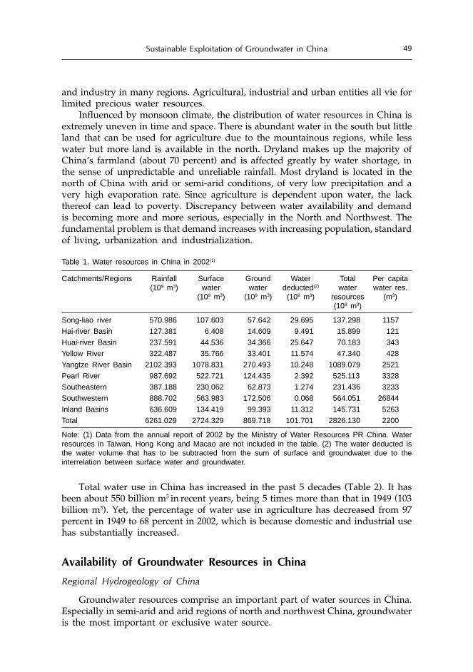
Sustainable Exploitation of Groundwater in China 49
and industry in many regions. Agricultural, industrial and urban entities all vie forlimited precious water resources.
Influenced by monsoon climate, the distribution of water resources in China isextremely uneven in time and space. There is abundant water in the south but littleland that can be used for agriculture due to the mountainous regions, while lesswater but more land is available in the north. Dryland makes up the majority ofChina’s farmland (about 70 percent) and is affected greatly by water shortage, inthe sense of unpredictable and unreliable rainfall. Most dryland is located in thenorth of China with arid or semi-arid conditions, of very low precipitation and avery high evaporation rate. Since agriculture is dependent upon water, the lackthereof can lead to poverty. Discrepancy between water availability and demandis becoming more and more serious, especially in the North and Northwest. Thefundamental problem is that demand increases with increasing population, standardof living, urbanization and industrialization.
Table 1. Water resources in China in 2002(1)
Catchments/Regions Rainfall Surface Ground Water Total Per capita(109 m3) water water deducted(2) water water res.
(109 m3) (109 m3) (109 m3) resources (m3)(109 m3)
Song-liao river 570.986 107.603 57.642 29.695 137.298 1157
Hai-river Basin 127.381 6.408 14.609 9.491 15.899 121
Huai-river Basin 237.591 44.536 34.366 25.647 70.183 343
Yellow River 322.487 35.766 33.401 11.574 47.340 428
Yangtze River Basin 2102.393 1078.831 270.493 10.248 1089.079 2521
Pearl River 987.692 522.721 124.435 2.392 525.113 3328
Southeastern 387.188 230.062 62.873 1.274 231.436 3233
Southwestern 888.702 563.983 172.506 0.068 564.051 26844
Inland Basins 636.609 134.419 99.393 11.312 145.731 5263
Total 6261.029 2724.329 869.718 101.701 2826.130 2200
Note: (1) Data from the annual report of 2002 by the Ministry of Water Resources PR China. Waterresources in Taiwan, Hong Kong and Macao are not included in the table. (2) The water deducted isthe water volume that has to be subtracted from the sum of surface and groundwater due to theinterrelation between surface water and groundwater.
Total water use in China has increased in the past 5 decades (Table 2). It hasbeen about 550 billion m3 in recent years, being 5 times more than that in 1949 (103billion m3). Yet, the percentage of water use in agriculture has decreased from 97percent in 1949 to 68 percent in 2002, which is because domestic and industrial usehas substantially increased.
Availability of Groundwater Resources in China
Regional Hydrogeology of China
Groundwater resources comprise an important part of water sources in China.Especially in semi-arid and arid regions of north and northwest China, groundwateris the most important or exclusive water source.

Menggui Jin, Xing Liang, Yinglan Cao and Renquan Zhang50
Table 2. Total annual water use in China (109 m3)
Year Total water use Industry Agriculture Domestic
1949 103.1 2.4 (2.33%) 100.1 (97.09%) 0.6 (0.58%)
1957 204.8 9.6 (4.69%) 193.8 (94.63%) 1.4 (0.68%)
1965 274.4 18.1 (6.60%) 254.5 (92.75%) 1.8 (0.66%)
1979 476.7 52.3 (10.97%) 419.5 (88.00%) 4.9 (1.03%)
1980 440.3 41.8 (9.5%) 370.7 (84.2%) 27.4 (6.3%)
1997 556.6 112.1 (20.1%) 391.7 (70.4%) 52.5 (9.4%)
1999 559.1 115.9 (20.7%) 386.9 (69.2%) 56.3 (10.1%)
2000 549.8 113.9 (20.7%) 378.4 (68.8%) 57.5 (10.5%)
2002 549.7 114.3 (20.8%) 373.8 (68.0%) 61.6 (11.2%)
Note: Data from annual reports by the Ministry of Water Resources and Liu and Chen (2001).
Physiographic and hydrogeological conditions of China vary greatly in differentregions. From the 1950s, regional hydrogeological mapping, primarily on the scaleof 1:200,000, has been carried out under the Ministry of Geology. Regional surveyinghas covered most areas of the territory.
Based on regional hydrogeological mapping, China is characterized by a greatcomplexity of its regional hydrogeological conditions and may be divided into thefollowing six main hydrogeological regions (Fig 2, Chen and Cai, 2000):• The Songliao Plain and Huang-Huai-Hai Plain, with enormously thick
unconsolidated sediments forming multiple aquifers recharged principally byvertical infiltration of rainfall.
• Inner Mongolian Plateau and Loess Plateau, an intermediate zone between thesemi-humid zone in the east and the dry desert zone in the west.
• The Western Inland Basins, consisting mainly of the Hexi Corridor, DzungariaBasin, Tarim Basin and Saidam Basin, typical arid desert land, usually withplenty of groundwater in broad piedmont plains.
• The Southeast and Central-south Hilly Land, characterized by different kind ofrocks widely exposed, fissure water dominates in this area.
• The Southwest Karst Hilly Land, characterized by wide distribution of carbonaterocks, where karst water and subterranean drainage are well developed.
• The Tibet Plateau, with an average elevation of around 4000m. The aquifers aremainly of the permafrost or glacial genetic type and groundwater is entirelyunder the control of vertical zoning.According to medium of aquifers, groundwater in China can mainly be
classified as pore water, karst water and fissure water. Pore water is most prevalentand used most intensively. Karst water takes second place and fissure water last.
Available Groundwater Resources and the Distribution
Based on regional groundwater investigations and observation data mainly inthe 1990s, it is estimated that total groundwater recharge (renewable freshgroundwater resources) in China amounts to 883.6 x 10⁹ m3/yr, approximating 31percent of total water resources. Allowable yield of fresh groundwater resource is352.8 x 109 m3/yr, or 40 percent of total available amount (Ministry of Land andResources, 2003). Allowable yield of brackish water (1-3 g/L in TDS) is 13 x 109 m3/yr.

Sustainable Exploitation of Groundwater in China 51
Figure 2. Hydrogeological regions in China (Insert: South China Sea)(Chen and Cai, 2000)I1. The Songliao Plain; I2. Huang-Huai-Hai Plain; II1. Inner Mongolian Plateau; II2 Loess Plateau; III. TheWestern Inland basins; IV. The Southeast and Central-south Hilly Land; V. The Southwest Karst HillyLand; VI. The Tibet Plateau
In the Standard for Hydrogeological Investigation of Water Supply (GAQSIQand MOC, 2001), the allowable yield of groundwater resources is defined as: thewater amount that can be sustainably abstracted from a groundwater system or ahydrogeological region by a certain rational pumping technique and scheme,resulting in a drawdown and variation of water quality that are within allowableranges without any permanent damage to the geo-environments.
Distribution of regional groundwater in China has been estimated in 26 regionsbased on hydrogeological conditions (see Figure 1 and Table 3). Recharge modulesfor Pearl River Catchments is 322.4 x 10³ m3/km2·yr; Yangtze River Catchments148.2 x 103 m3/km2·yr; Yellow River Catchments is 61.1 x 10³ m3/km2·yr; andNorthwest area is less than 50 x 103 m3/km2·yr.
Groundwater in southern China is abundant, accounting for 71 percent of totalnational groundwater resources, while groundwater in northern China covering 60percent of the land accounts for 29 percent only, and northwest regions coveringone third of the land accounts for only 13 percent.
Besides, affected by population, farmland, and economy development, thereexists great differences in groundwater availability per person and per ha farmlandthroughout the country. Water availability per person and per ha farmland is thelowest in the North China (Hai-river, Huai-river and Yellow River Basin), and thehighest in southwest regions (Table 1). Groundwater per person in southeast andsouth-central regions is higher than north and northeast region of China.Groundwater per person in southwest is two times higher than the average of thecountry (Chen and Ma, 2002).
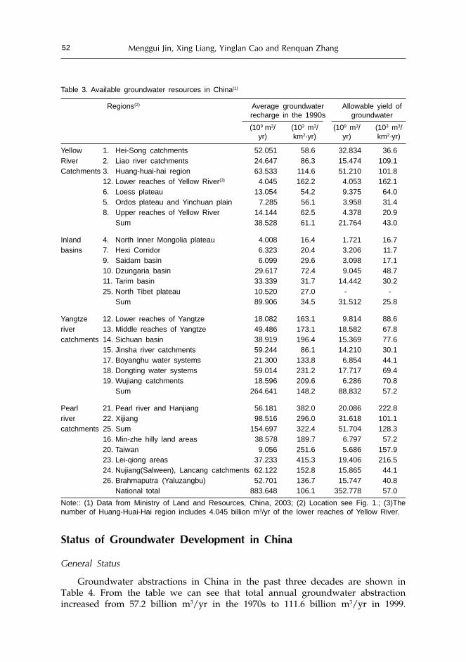
Menggui Jin, Xing Liang, Yinglan Cao and Renquan Zhang52
Table 3. Available groundwater resources in China(1)
Regions(2) Average groundwater Allowable yield ofrecharge in the 1990s groundwater
(109 m3/ (103 m3/ (109 m3/ (103 m3/yr) km2·yr) yr) km2·yr)
Yellow 1. Hei-Song catchments 52.051 58.6 32.834 36.6River 2. Liao river catchments 24.647 86.3 15.474 109.1Catchments 3. Huang-huai-hai region 63.533 114.6 51.210 101.8
12. Lower reaches of Yellow River(3) 4.045 162.2 4.053 162.16. Loess plateau 13.054 54.2 9.375 64.05. Ordos plateau and Yinchuan plain 7.285 56.1 3.958 31.48. Upper reaches of Yellow River 14.144 62.5 4.378 20.9
Sum 38.528 61.1 21.764 43.0
Inland 4. North Inner Mongolia plateau 4.008 16.4 1.721 16.7basins 7. Hexi Corridor 6.323 20.4 3.206 11.7
9. Saidam basin 6.099 29.6 3.098 17.110. Dzungaria basin 29.617 72.4 9.045 48.711. Tarim basin 33.339 31.7 14.442 30.225. North Tibet plateau 10.520 27.0 - -
Sum 89.906 34.5 31.512 25.8
Yangtze 12. Lower reaches of Yangtze 18.082 163.1 9.814 88.6river 13. Middle reaches of Yangtze 49.486 173.1 18.582 67.8catchments 14. Sichuan basin 38.919 196.4 15.369 77.6
15. Jinsha river catchments 59.244 86.1 14.210 30.117. Boyanghu water systems 21.300 133.8 6.854 44.118. Dongting water systems 59.014 231.2 17.717 69.419. Wujiang catchments 18.596 209.6 6.286 70.8
Sum 264.641 148.2 88.832 57.2
Pearl 21. Pearl river and Hanjiang 56.181 382.0 20.086 222.8river 22. Xijiang 98.516 296.0 31.618 101.1catchments 25. Sum 154.697 322.4 51.704 128.3
16. Min-zhe hilly land areas 38.578 189.7 6.797 57.220. Taiwan 9.056 251.6 5.686 157.923. Lei-qiong areas 37.233 415.3 19.406 216.524. Nujiang(Salween), Lancang catchments 62.122 152.8 15.865 44.126. Brahmaputra (Yaluzangbu) 52.701 136.7 15.747 40.8
National total 883.648 106.1 352.778 57.0
Note:: (1) Data from Ministry of Land and Resources, China, 2003; (2) Location see Fig. 1.; (3)Thenumber of Huang-Huai-Hai region includes 4.045 billion m3/yr of the lower reaches of Yellow River.
Status of Groundwater Development in China
General Status
Groundwater abstractions in China in the past three decades are shown inTable 4. From the table we can see that total annual groundwater abstractionincreased from 57.2 billion m3/yr in the 1970s to 111.6 billion m3/yr in 1999.

Sustainable Exploitation of Groundwater in China 53
Current groundwater abstraction accounts for 20 percent of total water use inChina.
The area with the highest intensity of groundwater exploitation is north Chinaplains (NCP) where groundwater plays a very important role to water supply andapproximately provides 52 percent of total water use. For urban ,domestic andindustrial use, groundwater contributed 80~90 percent in 1999. For agriculturaluse, groundwater contributed approximately 38 percent on the average in the NCP.In Hebei province, groundwater occupies 75 percent of total water supply andbeyond 50 percent in Shanxi and Henan province (MLD, 2003).
Influenced by the distribution of water resources and population and economicdevelopment and groundwater exploitation conditions, the imbalance ofgroundwater supply and demand is very serious in cities of north China. So far,there are almost 400 cities whose main water sources are groundwater. More than300 cities suffer from water stress and scarcity, which are mainly located in thenorth China.
Furthermore, groundwater pollution in urban areas is rather serious. Anuncompleted statistics showed that there are 136 large and medium cities wheregroundwater has been contaminated to varying degrees. Main pollution sourcesare industrial and domestic pollution. Groundwater has been polluted also in someagricultural regions, mainly near suburbs. There were over 1.33 M ha farmlandirrigated with industrial wastewater in 2000, directly polluting groundwater there.Groundwater is polluted by pesticides and fertilizers in some areas (Chen and Cai,2000). There are observation networks of groundwater throughout China; somewells are monitored thrice a year and some once a year.
Over-exploitation of Groundwater in Northern China
Groundwater in northern China (especially Hebei, Beijing and Tianjin provinces)has been intensively exploited. In most areas of northern China, especially largeand medium sized cities, groundwater has been seriously overexploited (CIGEM,2003).
For example, actual groundwater abstraction in Hebei province in 1999 was14.946 billion m3 (including 2.196 billion brackish groundwater of TDS 1-5g/L), butits recharge of fresh groundwater is estimated at 13.160 billion m3 and theallowable yield of fresh groundwater is only 9.954 billion m3/yr. This means thatabout 1.8 billion m3 of fresh groundwater is overexploited every year. Theoverexploitation has resulted in serious environmental problems.
Because of the monsoon influence, the rainfall and runoff in the semi-aridHebei are highly variable over the year, with, 60-70 percent of the annualprecipitation (500-600mm) and runoff being concentrated between June and August.This water resource seasonality thus produces a spectrum of natural disasters suchas spring droughts, autumn floods, soil salinization and alkalization, salinegroundwater, which limit the expansion of agriculture in the area. In addition, withthe development of agriculture since the 1980s, long-term groundwater over-extraction has led to a reduction in volume of fresh unconfined groundwater andcontinued lowering of groundwater levels for deep fresh confined water. This hasresulted in serious environmental problems such as seawater intrusion, saline

Menggui Jin, Xing Liang, Yinglan Cao and Renquan Zhang54
connate water invasion into fresh groundwater, land subsidence, etc. Consequently,the conflicts between socio-economic development and environmental protectionbecome increasingly critical (Jin et al., 1999b).
Table 4. Groundwater abstractions in China in last three decades (109m3/yr.)
Provinces, Mean Mean Mean Change in Change inautonomous annual annual annual abstraction abstractionregions or abstraction abstraction abstraction 1980s-1970s 1999-1980sMunicipalities in 1970s in 1980s in 1999
Beijing 2.562 2.733 2.715 0.171 -0.018
Tianjin 0.714 0.809 0.633 0.095 -0.176
Hebei 11.403 13.900 14.946 2.497 1.046
Shanxi 2.628 3.030 4.199 0.402 1.169
Inner Mongolia - - 5.987 - -
Liaoning 2.675 4.688 6.869 2.013 2.181
Jilin 0.935 1.300 2.992 0.365 1.692
Heilongjiang 2.809 5.821 6.500 3.012 0.679
Shanghai 0.078 0.112 0.104 0.034 -0.008
Jiangsu 0.195 0.655 1.834 0.460 1.179
Zhejiang 0.090 0.409 0.608 0.319 0.199
Anhui 0.920 1.071 1.848 0.151 0.777
Fujian 0.379 0.559 0.607 0.180 0.048
Jiangxi 0.524 0.828 1.251 0.304 0.423
Shandong 9.014 10.270 12.299 1.256 2.029
Henan 7.730 8.700 12.972 0.970 4.272
Hubei 0.051 0.923 1.397 0.872 0.474
Hunan - 0.184 2.587 0.184 2.403
Guangdong - - 2.200 - -
Guangxi 0.226 1.024 1.304 0.798 0.280
Hainan 0.290 - 0.492 -0.290 0.492
Chongqing 0.120 0.352 0.857 0.232 0.505
Sichuan 1.729 2.083 2.816 0.354 0.733
Guizhou 2.223 2.668 3.333 0.445 0.665
Yunnan - 0.067 0.628 0.067 0.561
Tibet(Xizang) - - 0.166 -
Shaanxi 2.645 2.368 3.419 -0.277 1.051
Gansu 1.818 2.006 2.622 0.188 0.616
Qinghai 0.095 0.263 0.540 0.168 0.277
Ningxia 0.221 0.456 0.555 0.235 0.099
Xinjiang 1.500 3.750 5.135 2.250 1.385
Taiwan 3.631 3.801 7.139 0.170 3.338
National total 57.205 74.830 111.554 17.625 36.724
Note: data from the Ministry of Land and Water Resources, 2003.

Sustainable Exploitation of Groundwater in China 55
Groundwater level depth for the deep freshwater in NCP was in the order of20-100 m in 2001, but it was near surface, even artesian in the 1960s. Rates ofgroundwater level declines for the deep fresh aquifers in depression cones are 1-2 m/yr. Cangzhou, a coast city in eastern Hebei plain, is one of the cities with mostserious water level decline of deep confined aquifers, 100 m decline since the 1960s.The water head declines have resulted in land subsidence, degradation of waterquality, and harmful ions being released during consolidation of the aquitards,besides increased costs of pumping.
The water table depth of the shallow groundwater in 90 percent of the areasof NCP was larger than 2 m, 50 percent being larger than 10m in 2001. Thelowering of water table has resulted in some disadvantages to ecology andenvironment, but one positive result is that soil salinization is decreasing in mostareas of the plain.
In some areas or cities of China, although groundwater exploitation is smallerthan allowable yield on the whole catchments, local overexploitation has happenedbecause of over-concentrated exploitation with high intensity in certain areas (Wuet al., 2004). This also resulted in groundwater table decline, land subsidence andwater quality degradation.
Great Potential of Groundwater Exploitation in Southern China
Since rainfall and surface water in southern China is relatively abundant, largeand medium sized cities in southern China mostly utilize surface water as mainsources for water supply. Currently, the contribution of groundwater to watersupply in most areas of southern China is low, and groundwater development hasgreat potential.
However, many areas in southern China have shifted to use good qualitygroundwater for water supply because surface water has been contaminated withthe development of economy. The proportion of domestic water use fromgroundwater is increasing year by year, e.g., Guangzhou, Guangdong Province,and Fuzhou, Fujian province in southern China. Groundwater abstraction inGaungzhou city accounts for 96 Mm3 in 1997, of which 52 Mm3 was for domesticuse, 18 Mm3 for industry and 26 Mm3 for agriculture; its groundwater abstractionis planned to be 206 Mm3 in 2005. Allowable yield of groundwater in Guangzhouis estimated at 403.85 Mm3/yr (Wu et al., 2004 ).
Strategies for Sustainable Use of Groundwater
Problems and Constraints for Sustainable Exploitation of Groundwater
Main problems of unsustainable exploitation of groundwater in China areirrational abstraction or over-exploitation of groundwater in northern and northwestChina and its associated problems and groundwater pollution in many areas.These certainly threaten sustainable development of the local economy. In addition,there are 41.08 M people (12.66 M in northwest) from 569 counties in West Chinabeing short of drinking water, usually areas associated with poverty (CIGEM,2003).

Menggui Jin, Xing Liang, Yinglan Cao and Renquan Zhang56
Besides uneven distribution of water resources and the natural conditions ofdrought, the water shortage situation is aggravated by irrational development andutilization of groundwater, poor management of water resources and poor studiesof groundwater (in some areas). While water shortage occurs widely, a largeamount of water is wasted. While over-irrigation has resulted in soil salinizationand water-logging in some areas, over-use of surface water and over-exploitationof groundwater has resulted in soil desertification and environmental deteriorationin other areas of the same river basin. For example, in the Sangong river catchments,North of Xinjiang Autonomous Uygur Region (XAUR), Northwest China,groundwater has been intensively abstracted in the diluvium/alluvium fans, andthen conducted to reservoirs in the alluvium plain for irrigation in the last threedecades. Observations show that the water table is significantly declining in thealluvium fans, but rising in the alluvium plain from irrigation and the plainreservoirs. This water table rising has resulted in serious soil salinization in the aridarea.
In the Hebei plain (main part of NCP) deep fresh water is extracted, whereasthe shallow brackish groundwater is not used much. Management options forwater problems in the plains include water demand management on the basis ofwater resource conditions, like: limiting water intensive industries, restrictedpumping of deep fresh water; use of brackish water for irrigation; extension ofwater-saving irrigation; reuse of wastewater and so on (Zhang et al., 1994; Jin et al.,1999a). The use of shallow brackish water will make recharge of rainfall to shallowgroundwater more effective (Jin et al., 1998; 1999a). Many field experiments andfarmer practices in the past three decades have proved that brackish water with 2-5 mg/L in TDS can be used for irrigation and water-saving irrigation and brackishwater use have great potential in NCP. Practices of water-saving irrigation in NCPhave advanced somewhat, while irrigation quotas have been significantly reducedin the past decade. Water-saving irrigation and brackish water irrigation are theprincipal ways for sustainable use of groundwater in the plain. However, furtherextension of management practices to water-saving irrigation, brackish waterirrigation, and restricting abstraction of deep fresh water is facing difficulty.
The reasons of irrational use of water or irrational abstraction of groundwaterare mainly inadequate water management institutions and policies, including:
• Poor awareness and recognition of the public (especially private farmers inChina) to water shortage and risk of irrational use of groundwater;
• Un-coordinated administration of a river basin;• Multi-agency sharing of water resources management (leads to a situation
where all agencies are partly responsible, but none is readily liable for thedamage);
• Separation of water quantity management and pollution control;• Low prices, even cost-free use of water for agriculture, leads to water wastage.
Table 5 shows that the water price in NWC is in the order of 0.6 -7.5 cents perm3 in 1998.

Sustainable Exploitation of Groundwater in China 57
Table 5. Water price for agriculture use in North China in1998 (Yuan/m3)
Provinces Water price Provinces Water price
Beijing 0.020 Gansu 0.030
Hebei 0.075 Inner Mongolia 0.023
Shanxi 0.062 Ningxia 0.006
Tianjin 0.040 Qinghai 0.040
Heilongjiang 0.024 Shaanxi 0.039
Ji’ning 0.030 Xinjiang 0.018
Liaoning 0.030
The above problems or constraints for sustainable exploitation of groundwaterhas received significant attention by scientists, economists and politicians in thepast decade, but still remain unresolved.
Enacting Laws and Rules for Groundwater Management
To accommodate new water resource management concepts and challenges,China promulgated its first version of the Water Law in 1988 and a modifiedversion of the Water Law in 2002. Related laws or rules include: Byelaw for Soiland Water Conservation (1982); Implementation Rules for License of Water Intake(1993); Law for Prevention and Cure of Water Pollution, promulgated in 1984 andmodified in 1996; Implementation Rules to the Law for Prevention and Cure ofWater Pollution, promulgated in 1989, modified in 2000; Administrative Rules toWater Resource Conservation for Construction Projects, promulgated in 2002; andso on.
According to these laws and rules, China’s water program must serve as theregulatory framework for a system that rationalizes and substantiates water andthe water infrastructure as public economic goods in the transition to a marketeconomy, with a preeminent role for the Ministry of Water Resources (MWR) asthe leading government body responsible for overall water planning, monitoring,research, and development. MWR also oversees national-level policymaking andinter-provincial policy coordination, and flood and drought protection and control.Ministry of Construction, Ministry of Land and Resources (MLR), EnvironmentalProtection Agency (EPA) participates in planning, research, development andprotection of water resources.
The policy shifted dramatically several years ago from primary emphasis onplanned structural engineering interventions (gongchengshuili in Chinese) to addresswater supply and control problems, and to recognition of the need for a morecomprehensive and diffuse notion of water as a resource (ziyuanshuili in Chinese) tobe developed and managed in response to changing market criteria.
Specific laws and rules for groundwater development in major river basins arebeing drafted. This is very important to examine and approve permits togroundwater intake, especially in water scarce areas.
Implementation and enforcement of these laws and rules are still confrontingdifficulties. One of the reasons may be that the laws and rules are not adaptive

Menggui Jin, Xing Liang, Yinglan Cao and Renquan Zhang58
enough to local situation and the market economy. The low water price maybe areason resulting in water waste. However, to increase water price may bring moreburden to poor farmers, which may cause conflict between farmers and waterauthorities. Obviously the capacity of water management is still not efficient andpowerful enough.
Well Investigations and Evaluation of Groundwater Resources
China has done a lot of work on investigation and evaluation of groundwaterand regional hydro-geological mapping, but the results in many cases are notpresented in formats suitable enough for examining and approving permits togroundwater intake and practical schemes of groundwater exploitation. Schemesof groundwater development should be easily operational for policymakers atdifferent levels and for individual water users.
Sustainable groundwater development and management is a complex task. Ashydrologists or hydro-geologists or engineers of water resources, we should makeour proposed schemes/planning of groundwater development user-friendly, easyto understand on the basis of well investigation and evaluations, and withconsideration of user’s demand. The proposed schemes should be optional forusers or decision makers.
Future Directions
Achieving sustainable use of groundwater is a shared task or duty for scientists,decision makers and all individual water users. It is an issue of multiple disciplines,and needs efforts from all parties.
Scientific and Technical Aspects
Hydro-geologists and hydrologists have had compelling professionalresponsibilities for safe and reliable use of both surface and groundwater. Theseinclude the development of scientific principles and the application of theseprinciples to satisfy the needs of society for sustained development.
Besides development of basic understanding and scientific principles of flowand transport of groundwater, further research needs to include:
• Development of more effective conceptual and numerical models for flow andtransport in large heterogeneous media (especially in fractured and solublerocks), including more refined transport models that couple flow and reactions.
• Better monitoring, investigation, evaluation of groundwater to establish user-friendly information systems at different levels for researchers, decision-makersand individual users.
• Better workable planning of groundwater development and utilizations, anduser-friendly decision support systems for decision-makers. Based on sustainableuse of water resources, this workable planning should be flexible to satisfysome biases of decision-makers and users and with enough consideration of allaspects related to water use, such as conjunctive use of surface and groundwater,

Sustainable Exploitation of Groundwater in China 59
well locations, pumping rates and penetration depth to aquifers, regional andlocal economic development, environmental protection, etc.
• Better techniques, e.g. well-setup for both water pumping and injections in finematerials of aquifers with low flow rates, water-saving irrigation and drainage,harmful compounds clean up, etc.
Non-technical Aspects
According to our investigation, the main reason for irrational exploitation ofgroundwater is the gap among groundwater researchers, decision-makers andwater users. Therefore we suggest:
• Strengthen public propaganda and education to enhance public awareness andknowledge of groundwater. Because of time constraints on planners, legislatorsand water managers, we can no longer assume that publication of articles inscientific journals, or even popular literature, will necessarily reach theappropriate decision-makers and stakeholders. Governmental institutions,universities, professional societies and other non-governmental organizationsmust devote efforts to develop programs to improve groundwater literacy ofthe public. It is particularly important for young children to become consciousof and sensitive to nature and the environment. These children are the futuredecision-makers. Such outreach will eventually demonstrate the desirability offunding for hydrogeology and related sciences (Back el al., 1997).
• Capacity building for sustainable water management, including adoption oflaws and rules for groundwater management from national to river basin level,in order to force and guarantee that all planners, legislators, water managersand water users are serving to sustainable use of groundwater in their dailyactivities.
• Creating work environments for better communication and sharing data/information among water managers, planners, decision-makers, scientists, waterusers and others to exchange ideas and knowledge for mending the gapsamong different parties, including international exchange and cooperation.
Conclusions
• China is listed as one of the 13 most water-deficient countries in the worldbased on per capita water availability. The averaged total amount of waterresources in China is 2826 billion m3/yr, and the per capita water resource isabout 2200 m3, which is only 31 percent of the world average. The distributionof water resources in China is extremely uneven in time and space. In theSouth, there is abundant water but little land that can be used for agriculturewhile less water but more land are available in the north. Water shortage islimiting the development of China’s economy.
• Groundwater is the most important or exclusive water source in arid or semi-arid regions of north and northwest China. Average groundwater recharge inChina estimated to be 883.6 billion m3/yr, approximating 31 percent of totalwater resources. Allowable yield of fresh groundwater resource is 352.8 billionm3/yr.

Menggui Jin, Xing Liang, Yinglan Cao and Renquan Zhang60
Groundwater pollution occurs throughout China, being rather serious in urbanareas. Main pollution sources are industrial and domestic pollution. Pesticidesand fertilizers in some agricultural areas also pollute groundwater
• Total annual groundwater abstraction in China increased from 57.2 billion m3/yr in the 1970s to 111.6 billion m3/yr in 1999. Current groundwater consumptionis approximating 20 percent of total water use of China. Groundwater in NCPaccounts for 52 percent of total water use, where groundwater in Hebeiprovince occupies 75 percent of total water supply and beyond 50 percent inShanxi and Henan province.In most areas of northern China, especially cities, groundwater has been over-exploited, but groundwater in south China still has great potential fordevelopment.
• To accommodate new water resource management concepts and challenges,China has promulgated many laws and rules in the 1980s and the 1990s andstill drafts complementarities and modifies previous ones.A dramatic policy shifted several years ago from primary emphasis on plannedstructural engineering interventions to address water supply and controlproblems and to recognize the need for a more comprehensive and diffusenotion of water as a resource to be developed and managed in response tochanging market criteria.
• Achieving sustainable use of groundwater is a shared task or duty for scientists,decision makers and all individual water users. The most important things areto enhance public awareness and knowledge of groundwater and to create awork environment for better communication and sharing dada/ informationamong water managers, planners, decision-makers, scientists, water users andothers to exchange ideas and knowledge and reduce the gaps between differentparties, including international exchanges and cooperation.
Acknowledgements
The authors gratefully acknowledge Dr. Karen G.. Villholth and Dr. Bharat R.Sharma for their kind invitation and constructive comments to write this paper,and the Natural Science Foundation of China (40472123, 49972083) for financialsupport to this research.
References
Back, William and Herman, Janet S. 1997. American Hydrogeology at the Millennium: An annotatedchronology of 100 most influential papers. Hydrogeology Journal. 5(4): 37-50.
Chen Mengxiong and Cai Zuhuang. 2000. Groundwater resources and the related environ- hydrogeologicproblems in China. Beijing: Seismological Press.
Chen Mengxiong and Ma Fengshan. 2002. Groundwater resources and the environment in China.Beijing: Seismological Press. (in Chinese).
Chen Zhikai. 1998. Sustainable development and utilization of water resources in China. Proceedingsof International Workshop on Barriers to Sustainable Management of Water Quantity andQuality. 1998, WUHEE, Wuhan, China. 61-68.
China Institute for Geo-Environmental Monitoring (CIGEM),. 2003. http://www.cigem.gov.cn/englishver/files/net21.htm; http://www.cigem.gov.cn/englishver/gw1.htm.

Sustainable Exploitation of Groundwater in China 61
General Administration of Quality Supervision, Inspection & Quarantine (GAQSIQ) and Ministry ofConstruction (MOC), P.R. China. 2001. Standard for Hydrogeological Investigation of WaterSupply, GB 50027-2001. Beijing: China Planning Press.
Jin Menggui, Zhang Renquan and Gao Yunfu. 1998. Sustainable irrigation with brackish groundwaterin Heilonggang Region, China. Journal of China University of Geosciences. Vol. 9. no.1. 90-94.
Jin Menggui, Zhang Renquan, Sun Lianfa, Gao Yunfu. 1999a. Coordination among agriculture, waterresources and environment for sustainable development. Wuhan: China University of GeosciencesPress. (In Chinese with English abstract).
Jin, M.G., Zhang, R.Q., Sun L.F., Gao, Y.F. 1999b. Temporal and spatial soil water management: a casestudy in the Heilonggang region, PR China. Agricultural Water Management, Elsevier. Vol 42:174-187.
Liu Chang-ming and Chen Zhi-kai. 2001. Evaluation of current status of water resources and analysisof trend of supply-demand development. Beijing: Press of Hydraulic and Electric Power. (inChinese).
Ministry of Land and Resources. 2003. Groundwater resources in China. (in Chinese).Peng Yihua, Long Jianzhong, Chen Shulin et al. 2001. Standard for hydrogeological investigation of
water supply (SHIWS), GB 50027-2001. Bureau of Quality Control of PR China. (in Chinese).Wu Ji-song, Li yan-ge, Guo Meng-zhu and Lu Rong-an (eds.). 2004. Development and utilization of
groundwater resources in China for early 21st century. Ministry of Water Resources. Beijing:China Press of Hydraulic and Electric Power. (in Chinese).
Zhang R.Q., Jin, M.G, Sun, L.F. and Gao, Y.F. 1994. Systems analysis of agriculture-water resources-environment in Hebei Plain. Proceedings of the Water Down Under 1994 Conference. Adelaide,Australia, November 21-25, 1994, Vol.1: 453-458.

Status of Groundwater and Policy Issues for itsSustainable Development in India
M. MehtaMinistry of Water Resources, Shram Shakti Bhawan, New Delhi, India
Abstract
There has been unprecedented groundwater development in India due to which theirrigation potential has increased manifold from 6.5 M ha to 45.7 M ha by the end of theVIII Plan. Out of an estimated maximum irrigation potential of 81.4 M ha in the minorirrigation sector, 64.0 M ha (79 percent) is estimated to be associated with groundwater.
The present paper deals with the groundwater resources availability in different partsof the country, bringing out areas, which are under stress, and also areas where groundwaterdevelopment is at a relatively low level and further development of groundwater is possible.The contamination of groundwater due to geo-genic sources is also discussed in this paperwith special emphasis on the arsenic and fluoride contamination, which has adverselyaffected a large population in the country.
Several issues need to be addressed for a proper approach to sustainable managementof groundwater. The approach so far has been more towards the development of the resourcerather than the management of it, which has resulted in haphazard development and over-development in some areas and contamination in other areas. The legal provision ofgroundwater rights to the landowner has lead to indiscriminate development of groundwater.Shortages of water in many areas and also the land ownership rights have lead to thedevelopment of water markets all over the country and especially in the water scarce areas.Sustainable groundwater management would require that groundwater is not consideredin isolation but should also include artificial recharge and conservation, conjunctive use,land use planning as per the availability of water, and taking appropriate measures to avoidpollution. In the present scenario of scarcity of groundwater resources, the provision of freeor subsidized power in the agriculture sector also needs to be given a fresh look.
Introduction
People around the world have used groundwater as a source of drinking waterand even today more than half of the world’s population depends on groundwaterfor survival. Groundwater has played a significant role in maintenance of India’seconomy, environment and standard of living. Besides being the primary source ofwater supply for domestic and many industrial uses, it is the single largest andmost productive source of irrigation. Out of the ultimate irrigation potential of

Status of Groundwater and Policy Issues - India 63
81.4 M ha in India, in the minor irrigation sector, 64.0 M ha (79 percent) is fromgroundwater. It also provides water security during prolonged drought periods.
Groundwater Scenario in India
The total annual groundwater recharge in India is estimated at 432 billion cubicmeters (BCM). After deducting the natural loss to the system, the net annualgroundwater availability in the country is 361 BCM. The total annual groundwaterdraft is 150 BCM. In the states of Haryana, Punjab and Rajasthan, the stage ofgroundwater development is more than 85 percent and in Haryana and Punjab,heavy groundwater withdrawal have likewise resulted in high stage of groundwaterdevelopment. In some parts of the country, such as the North Eastern States,groundwater development has not picked up yet. Presently, 673 assessment unitsof the country (see explanation in Table 1) are ‘over-exploited’ where the annualgroundwater extraction exceeds the annual recharge. 425 assessment units are‘dark’ or ‘critical’ where the groundwater development has reached to a high level,i.e. > 85 percent. Remaining 7091 blocks have been categorized as ‘safe’, havingadequate groundwater resources for further development (Table 1).
Apart from the dynamic resource, a vast amount of in-storage resource (non-replenishable) is available at deeper levels. A first approximation indicates that thetotal in-storage groundwater reserve is around 10,812 BCM. In-storage groundwaterreserves are particularly abundant in the alluvial deposits of Indo-Gangetic-Bramhaputra valley spreading in the northern and northeastern parts of thecountry.
The behavior and distribution of groundwater in the Indian sub-continent isnot even. In fact it is complicated due to the occurrence of diversified geologicalformations and complex tectonic framework, climatic dissimilarities and varioushydro-chemical conditions. The state wise availability of groundwater is summarizedin Table 2.
Priority issues in the groundwater sector vary from place to place dependingon the existing hydro-geological setup and the stress effect on it as a result ofhuman interference. Groundwater is becoming an increasingly popular resourcebecause of the relative ease and flexibility with which it can be tapped. Groundwaterdevelopment has also occupied an important place in poverty alleviation policiesbecause of its role in stabilizing the Indian agriculture and as means for droughtmanagement. During periods of droughts, additional dependence is laid on thisresource since storage levels in surface water reservoirs dwindle and the impact ofvagaries of weather on groundwater is not as pronounced and is delayed.
The average stage of groundwater development in the country, as estimated in1991, was 32 percent. In March 2003, the average stage of development had reachedapproximately 42 percent. This is also evident from the growth of groundwaterabstraction structures from the pre-VIII plan period till date. The number ofgroundwater abstraction structures (dug wells, shallow and deep tube wells) hasincreased from merely 4 million in 1951 to more than 17 million in 1997. With thegrowth of groundwater abstraction structures, there has been an increase inirrigation potential created from groundwater from 6.5 M ha to 45.7 M ha by the endof the VIII Plan. This rapid pace is likely to continue till the full irrigation potentialestimated to be available from groundwater is created by approximately 2007.

M. Mehta64
Table 1. Groundwater development levels in India
States Number of No. of assessment units
assessment Over-exploited Dark/Critical
units No. % No. %
1. Andhra Pradesh 1157 118 10.20 79 6.83
2. Arunachal Pradesh 59 0 0.00 0 0.00
3. Assam 219 0 0.00 0 0.00
4. Bihar 394 6 1.52 14 3.55
5. Chhattisgarh 145 0 0.00 0 0.00
6. Delhi 6 3 50.00 1 16.07
7. Goa 12 0 0.00 0 0.00
8. Gujarat 180 41 22.78 19 10.56
9. Haryana 111 30 27.03 13 11.50
10. Himachal Pradesh 69 0 0.00 0 0.00
11. Jammu & Kashmir 69 0 0.00 0 0.00
12. Jharkhand 193 0 0.00 0 0.00
13. Karnataka 175 7 4.00 9 5.14
14. Kerala 151 3 1.99 6 3.97
15. Madhya Pradesh 312 2 0.64 1 0.34
16. Maharashtra 2316 154 6.65 72 3.11
17. Manipur 29 0 0.00 0 0.00
18. Meghalaya 39 0 0.00 0 0.00
19. Mizoram 12 0 0.00 0 0.00
20. Nagaland 52 0 0.00 0 0.00
21. Orissa 314 0 0.00 12 8.70
22. Punjab 138 81 58.70 80 33.76
23. Rajasthan 237 86 36.29 0 0.00
24. Sikkim 4 0 0.00 37 9.61
25. Tamil Nadu 385 138 35.84 0 0.00
26. Tripura 38 0 0.00 20 2.44
27. Uttar Pradesh & 819 2 0.24 61 22.18
Uttaranchal
28. West Bengal 275 0 0.00 61 22.18
Total States 7910 671 8.48 424 5.36
Union Territories 18 2 11.11 1 5.56
Grand Total 7928 673 8.49 425 5.36
Notes: 1. Unit of Assessment : Andhra Pradesh –Basin, Maharashtra –Watershed(Command/Non-command wise); Gujarat,Karnataka -Taluka : Rest of the States – Blocks 2. Methodology for Estimation: Groundwater Estimation Committee(GEC) Guidelines ‘97 – Andhra Pradesh, Chhattisgarh, Jammu &Kashmir, Kerala, Maharashtra, Orissa, Rajasthan, Tamil Nadu, Uttar Pradesh, Andaman & NicobarIsland. GEC ’84 – Rest of the states. 3. Criteria for Categorisation – Over-exploited – GEC ’84 > 100%,GEC ’97 >100%. Declining trend in both pre & post monsoon water level.Dark – GEC ’84 > 85% & <= 100%, Critical-GEC ’97 < 100%, Declining trend in both pre & post monsoon water level OR > 100%.

Status of Groundwater and Policy Issues - India 65
Table 2. State wise availability of groundwater resources
Sl. State Total Provision for Available Net Balance Level ofNo. replenishable domestic, groundwater draft groundwater groundwater
groundwater industrial resources resources for developmentresource and other for irrigation future use
usesBCM/Yr BCM/Yr BCM/Yr BCM/Yr BCM/Yr (%)
1. Andhra Pradesh 35.29 5.29 30.00 8.57 21.43 28.56
2. Arunachal Pradesh 1.44 0.22 1.22 - 1.22 Neg
3. Assam 24.72 3.71 21.01 1.84 19.17 8.75
4. Bihar 26.99 4.05 22.94 10.63 12.31 46.33
5. Chattisgarh 16.07 2.41 13.66 0.81 12.85 5.93
6. Delhi 0.29 0.18 0.11 0.12 - -
7. Goa 0.22 0.03 0.19 0.02 0.17 8.30
8. Gujarat 20.38 3.06 17.32 9.55 7.77 55.16
9. Haryana 8.53 1.28 7.25 8.13 0.00 112.18
10. Himachal Pradesh 0.37 0.07 0.29 0.03 0.26 10.72
11. Jammu & Kashmir 4.43 0.66 3.76 0.03 3.73 0.81
12. Jharkhand 6.53 0.98 5.55 1.84 3.71 33.13
13. Karnataka 16.19 2.43 13.76 4.76 9.00 34.60
14. Kerala 7.90 1.31 6.59 1.46 5.13 22.17
15. Madhya Pradesh 34.82 5.22 29.60 8.02 21.58 27.09
16. Maharashtra 37.87 12.40 25.47 9.44 16.04 37.04
17. Manipur 3.15 0.47 2.68 Neg. 2.68 Neg.
18. Meghalaya 0.54 0.08 0.46 0.02 0.44 3.97
19. Mizoram* 1.40* 0.21* 1.19* Neg. 1.19* Neg.
20. Nagaland 0.72 0.11 0.62 Neg. 0.62 Neg.
21. Orissa 20.00 3.00 17.00 3.61 13.39 21.23
22. Punjab 18.66 1.87 16.79 16.40 0.00 97.66
23. Rajasthan 12.71 1.99 10.71 9.26 1.45 86.42
24. Sikkim 0.07* 0.01* 0.06* Neg. 0.06* Neg.
25. Tamil Nadu 26.39 3.96 22.43 14.45 7.98 64.43
26. Tripura 0.66 0.10 0.56 0.19 0.38 33.43
27. Uttar Pradesh 81.12 12.17 68.95 32.33 36.62 46.89
28. Uttaranchal 2.70 0.41 2.29 0.82 1.47 35.78
29. West Bengal 23.09 3.46 19.63 7.50 12.13 38.19
Total States 433.00* 71.14* 361.98* 149.82 212.78* 41.53(431.77) (70.92) (360.73) (211.53)
Total Union Territories 0.442* 0.025* 0.384 0.160 0.348*(0.116) (0.012) (0.071) (0.035)
Grand Total 433.882* 71.165* 362.364* 149.97 213.128* 41.57(431.886) (70.932) (360.80) (211.56)
Note: 1995 estimates are projected to 2003* Total Replenishable Groundwater Resource of the country was estimated to be 433.68 BCM. However,as per decision taken in 1995, the agreed figure of 432 BCM is retained as rounded off figure of 431.88BCM. The discrepancy actually has crept in due to inclusion of figures in respect of Mizoram, Sikkimand UT of Andaman & Nicobar at a later stage.

M. Mehta66
Groundwater Quality
The chemical quality of groundwater plays a vital role in its various uses. Thegeochemical and geothermal characteristics of groundwater are dependent on theinterplay of meteorological, geological, pedological and topographical conditions,which have a direct bearing on the natural concentration of salts in groundwater.The chemical quality of groundwater occurring within shallow depths varieswidely in the country because of human interference. Generally, the chemicalconstituents that affect the potability of groundwater, are within the permissiblerange in major parts of the country. In places, the groundwater has high geo-genicconcentration of fluoride, nitrate, iron, arsenic, salinity and dissolved salts, whichrestricts its use for various purposes. The district wise problems of contaminationof groundwater due to various contaminants are given in Table 3. The chemicalquality of groundwater has been affected through domestic, agricultural andindustrial pollution. Intensification of agricultural cultivation has lead to significantdeterioration in groundwater quality in some areas. The principal problems are theleaching of nutrients, and pesticides, and increasing salinity in the more arid orcoastal environments.
The subsoil and the underlying rock formations can eliminate or attenuatemany water pollutants by natural, physical, chemical and biological processes. Butthis natural capacity does not extend to all types of water pollutants and varieswidely in effectiveness under different hydro-geological conditions. Serious pollutionof groundwater occurs when pollutants are discharged to, deposited on, or leachedfrom the land surface, at rates significantly exceeding the natural attenuationcapacity. This is occurring widely as a result of both the indiscriminate disposal ofliquid effluents and solid wastes from urban development with inadequate sanitationarrangements, and of uncontrolled leakage of stored chemicals into the groundfrom industrial activities.
In many coastal areas, such as near Chennai and also in small islands, over-exploitation is leading to the intrusion of saltwater inland, causing effectivelyirreversible deterioration of groundwater resources.
Groundwater pollution is insidious and expensive; insidious because it takesmany years to show its full effect in the quality of water pumped from deep wells;expensive because, by the time it is detected, the cost of remediation of pollutedaquifers becomes extremely high. Indeed, restoration to drinking water standardsis often practically impossible.
Groundwater Issues
Developing and managing this resource in a sustainable way poses manychallenges. The major concerns of groundwater development and management inIndia are: low development in prospective areas and high rate of groundwaterdevelopment leading to groundwater depletion, groundwater quality problem dueto intrinsic properties of the rock formations and domestic, agricultural andindustrial pollution, in other areas.

Status of Groundwater and Policy Issues - India 67
Tabl
e 3.
Sta
tew
ise
deta
ils o
f co
ntam
inat
ion
of g
roun
dwat
er i
n so
me
area
s of
the
dis
tric
ts d
ue t
o va
rious
con
tam
inan
ts
S.
Sta
teS
alin
ityIr
onF
luor
ide
Nitr
ate
Ars
enic
Hea
vy m
etal
sN
o.
1.A
ndhr
aE
ast
God
avar
i,—
Pra
kasa
m,
Vis
hakh
apat
nam
, E
ast
God
avar
i,—
Ana
ntap
ur,
Meh
boob
naga
r,P
rade
shW
est
God
avar
i,N
ello
re,
Kris
hna,
Pra
kasa
m,
Nel
lore
,P
raka
sam
, V
isak
hapa
tnam
,K
rishn
a, G
untu
r,A
nant
apur
,C
hitto
or,
Ana
ntap
ur,
Cud
dapa
h,C
udda
pah,
Nal
gond
a.P
raka
sam
Nal
gond
a,K
urno
ol,
Meh
boob
-nag
ar,
Ran
gare
ddy,
Ran
gare
ddy,
Med
ak,
Adi
laba
d,A
dila
bad
Nal
gond
a, K
ham
mam
.
2.A
ssam
—N
orth
ern
Nag
aon,
——
Dig
boi
bank
of
Kar
biB
rahm
aput
raA
nglo
ng
3.B
ihar
Beg
usar
aiC
ham
para
n,G
iridi
h,P
alam
au,
Gay
a, P
atna
, N
alan
da,
—D
hanb
ad,
Muz
affa
rpur
,M
uzaf
farp
ur,
Jam
ui,
Naw
ada,
Bha
galp
ur,
Sah
ebgu
nj,
Beg
usar
ai.
Gay
a, M
unge
r,D
hanb
adB
anka
Deo
ghar
,M
adhu
bani
,P
atna
, P
alam
au,
Nal
anda
, N
awad
a,B
anka
4.G
ujar
atB
anas
kant
ha,
—K
achc
h,—
——
Juna
garh
,S
uren
dran
agar
,B
hara
uch,
Raj
kot,
Sur
at,
Ahm
edab
ad,
Meh
sana
,M
ehsa
na,
Ahm
edab
ad,
Ban
aska
ntha
,S
uren
dran
agar
,S
abar
kant
ha.
Khe
da,
Jam
naga
r
5.H
arya
naS
onep
at,
Roh
tak,
—R
ohta
k, J
ind,
Am
bala
, S
onep
at,
Jind
, G
urga
on,
—F
arid
abad
His
sar,
Sirs
a,H
issa
r, B
hiw
ani,
Far
idab
ad,
His
sar,
Sirs
a, K
arna
l,F
arid
abad
, Ji
nd,
Mah
endr
a-ga
rh,
Kur
uksh
etra
, R
ohta
k, B
hiw
ani,
Gur
gaon
, B
hiw
ani,
Far
idab
adM
ahen
drag
arh
Mah
endr
agar
h
6.H
imac
hal
——
—K
ulu,
Sol
an,
Una
—P
urw
anoo
, K
alaa
mb
Pra
desh
(Con
td.)

M. Mehta68
7.K
arna
taka
Bija
pur,
—Tu
mku
r, K
olar
,—
—B
hadr
awat
iB
elga
um,
Ban
galo
re,
Rai
chur
,G
ulba
rga,
Bel
lary
, D
harw
arB
ella
ry,
Rai
chur
8.K
eral
aE
rnak
ulam
,—
Pal
ghat
——
—Tr
ichu
r, A
llepp
ey
9.M
adhy
aG
wal
ior,
Bhi
nd,
—B
hind
, M
oera
na,
Seh
ore
Raj
nand
-B
asta
r, K
orba
,P
rade
sh &
Mor
ena,
Jha
bua,
Gun
a, J
habu
a,ga
onR
atla
m,
Nag
daC
hhat
isga
rhK
harg
aon,
Dha
r,C
hhin
dwar
a,S
hivp
uri,
Sha
japu
r,S
eoni
, M
andl
a,G
una,
Man
dsor
,R
aipu
r, V
idis
haU
jjain
10.
Mah
aras
htra
Am
arav
ati,
—B
hand
ara,
Tha
ne,
Jaln
a, B
eed,
Nan
ded,
——
Ako
la.
Cha
ndra
pur,
Latu
r, O
sman
abad
, S
olap
ur,
Nan
ded,
Sat
ara,
San
gli,
Kol
hapu
r,A
uran
gaba
dD
hule
, Ja
lgao
n, A
uran
gaba
d,A
hmed
naga
r, P
une,
Bul
dana
,A
mra
vati,
Ako
la,
Nag
pur,
War
dha,
Bha
ndar
a, C
hand
rapu
r,G
adch
iroli
11.
Oris
saC
utta
ck,
Par
ts o
fB
olan
gir
——
Ang
ul,
Talc
her
Bal
esw
ar,
Pur
iC
oast
al O
rissa
12.
Pun
jab
Bha
tinda
,—
Ludh
iana
,P
atia
la,
Far
idko
t, F
irozp
ur,
—Lu
dhia
na,
Man
diS
angr
ur,
Far
idko
t,S
angr
ur,
Bha
tinda
.G
obin
dgar
h.F
arid
kot,
Bha
tinda
,F
irozp
ur.
San
grur
,Ja
land
har,
Am
ritsa
r.
13.
Raj
asth
anB
hara
tpur
,B
ikan
er,
Alw
ar,
Bar
mer
, B
ikan
er,
Jaip
ur,
Chu
ru,
Gan
gana
gar,
—P
ali,
Uda
ipur
, K
hetr
i.Ja
ipur
, N
agau
r,D
unga
rpur
Gan
gana
gar,
Bik
aner
, Ja
lore
, B
arm
er,
Jalo
re,
Siro
hi,
Jalo
re,
Nag
aur,
Bun
di,
Sw
ai M
adho
pur.
Jodh
pur
Pal
i, S
irohi
.
Tabl
e 3.
(C
ontd
.)
S.
Sta
teS
alin
ityIr
onF
luor
ide
Nitr
ate
Ars
enic
Hea
vy m
etal
sN
o.
(Con
td.)
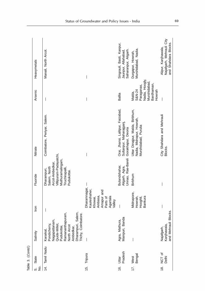
Status of Groundwater and Policy Issues - India 69
14.
Tam
il N
adu
Kar
aika
l,—
Dha
ram
puri,
Coi
mba
tore
, P
eriy
ar,
Sal
em.
—M
anal
i, N
orth
Arc
ot.
Pon
dich
erry
,S
alem
, N
orth
Nag
apat
tana
m,
Arc
ot-A
mbe
dkar
,Q
uide
-Mill
et,
Vill
ipur
am-P
aday
atch
i,P
uduk
otta
i,M
uthu
ram
alin
gam
,R
aman
anth
apur
am,
Tiru
chira
palli
,N
orth
Arc
otP
uduk
otta
i.A
mbe
dkar
,D
hara
mpu
ri, S
alem
,Tr
ichy
, C
oim
bato
re.
15.
Trip
ura
—D
hara
mna
gar,
——
——
Kau
lesh
aher
,K
how
ai,
Am
basa
,A
map
ur a
ndP
arts
of
Aga
rtal
aV
alle
y
16.
Utta
rA
gra,
Mat
hura
,—
Bul
ands
haha
r,O
rai,
Jhan
si,
Lalit
pur,
Fai
zaba
d,B
allia
Sin
grau
li, B
asti,
Kan
pur,
Pra
desh
Mai
npur
i, B
anda
Alig
arh,
Agr
a,S
ulta
npur
, M
ahar
ajga
nj,
Jaun
pur,
Alla
haba
d,U
nnao
, R
ae-B
arel
iG
orak
hapu
r, D
eoria
Sah
aran
pur,
Alig
arh.
17.
Wes
t—
Mid
napo
re,
Birb
hum
Utta
r D
inaj
pur,
Mal
da,
Birb
hum
,M
alda
,D
urga
pur,
How
rah,
Ben
gal
How
rah,
Nad
ia,
Mid
napu
r, H
owra
h,S
&N
-24
Mur
shid
abad
, N
adia
.H
oogh
li,M
ursh
idab
ad,
Pur
ulia
Par
agan
as,
Ban
kura
Nad
ia,
Hoo
gly,
Mur
shid
abad
,B
ardh
aman
,H
owra
h
18.
NC
T o
fN
ajaf
garh
,—
—C
ity S
hahd
ara
and
Meh
raul
i—
Alip
ur,
Kan
jhaw
ala,
Del
hiK
anjh
awal
a,B
lock
s.N
ajaf
garh
, M
ehra
uli
City
and
Meh
raul
i B
lock
s.an
d S
hahd
ara
Blo
cks.
Tabl
e 3.
(C
ontd
.)
S.
Sta
teS
alin
ityIr
onF
luor
ide
Nitr
ate
Ars
enic
Hea
vym
etal
sN
o.

M. Mehta70
While developing groundwater resources promises to help alleviate poverty inmany areas, the most formidable groundwater challenge is to attain the sustainableuse and management of groundwater in areas where the resource is under threat.The depletion of groundwater is becoming a major problem in many parts of thecountry. Groundwater overdraft has many negative consequences associated withit. The ultimate impact of groundwater depletion and water quality deteriorationis on the health of large sections of rural population that depend directly on wellsas their only source of drinking water supply. Depleting water tables is causing thedrilling of deeper wells and an ever-increasing cost of tapping these aquifers.
Developmental Issues in Indo-Ganges-Brahmaputra Basin
The groundwater resource is not evenly distributed throughout the country.Several regions in the country have a good repository of groundwater, which areyet to be tapped. The most significant is the Indo-Gangetic-Bramhaputra basin thatis bestowed with about 211 BCM of annual groundwater recharge, which is almost50 percent of the total potential of the country. It also has a vast in-storagegroundwater reserve. The groundwater development in this belt at a low levelleaves a good scope for further development.
Developmental Issues in Punjab and Haryana
The success of the Green Revolution in Punjab and Haryana brought with itselfthe adverse impact on the groundwater regime in the form of over draft. The effectis so pronounced that out of 36 districts in these two states, 25 districts have areaswhere decline in groundwater levels have set in.
Developmental Issues in Rajasthan
In the western arid sector of the country, in Rajasthan, there is little naturalrecharge to the groundwater regime. In sharp contrast, the INGP command areafaces the problem of land degradation due to water logging and consequent soilsalinity. The problems of meteorological and agricultural droughts and landdegradation due to water logging and soil salinity are required to be addressed onpriority.
Developmental Issues in Deltaic and Coastal Sediments
The unconsolidated deltaic and coastal sediments along India’s coastline containthick and regionally extensive aquifers that have good yield potential and cansustain deep, moderate to high capacity tube wells. Although enormous freshgroundwater resources are identified in these areas all along the coast, itsuncontrolled development suffers heavily from inherent salinity hazards. Coastalparts of Gujarat, Tamil Nadu and Andhra Pradesh are already suffering from theproblem of salinity ingress.

Status of Groundwater and Policy Issues - India 71
Developmental Issues in Peninsular States
The peninsular states of Maharashtra, Andhra Pradesh, Karnataka, TamilNadu and Kerala are characterized by hard rock formations, which lack primaryporosity and have extreme heterogeneity and restricted storage capabilities ofgroundwater. Occurrence of groundwater is limited to areas where the structure ofthe rock formations favors storage and transmission of groundwater.
Groundwater Ownership Issues
A private individual investing his own resource can construct wells of anydesign, installing pumps of any capacity. Under the Land Easement Act of 1882,groundwater is considered an easement connected to land. Ownership ofgroundwater thus falls to the landowner who is free to extract and use it as he/she deems fit. When the Easement Act was promulgated, the popular and prevalentmeans of groundwater withdrawal were through dug wells. With the advent ofelectrically powered pumps and advanced drilling methods, the situation haschanged drastically. The demand for groundwater has increased manifold. Between1951 and 1992, dug wells increased from 3.86 million to 10.12 million, shallow tubewells from 3000 to 5.38 million, public tube wells from 0 to 68,000, electric pumpsfrom zero to 9.34 million, and diesel pumps from 66,000 to 4.59 million. In the VIIIplan, a further addition of 1.71 million dug wells, 1.67 million shallow tube wells;114,000 deep tube wells 2.02 million electric pumps and 420,000 diesel pumps tookplace. Exclusive rights over water have resulted in not only exploitation of needyfarmers but also that of the groundwater resources.
Management Options
Presently, groundwater management rather than development is the majorchallenge that is being faced. There are certain strong reasons suggesting the needfor such a shift:• The private sector predominance in this sector is strong.• The expansion of groundwater management problems across many parts of the
country at a rapid rateWith the sustainable limits of groundwater extraction being approached,
competition between agriculture and other uses are intensifying. Naturally, allocationproblems are particularly complicated in areas where overdraft, quality andpollution problems exist. In some areas, current levels of use are being maintainedby mining groundwater resources. In these areas, cutbacks in extraction areessential, as are measures to dramatically increase the productivity per unit ofwater. In all areas, the challenge is to maintain extraction within sustainable limits.
The various management options to explore are:• Legal framework regarding use of groundwater.• Community support for this legal framework since the majority of the
groundwater structures in the country are privately owned. This would lead toeffective implementation of the regulations since there will be no oppositionfrom the local populace.

M. Mehta72
• Development of water markets, if established within effective rights, institutionaland regulatory framework could play a major role in providing water tovarious use sectors.
• Effective co-ordination and communication between various agencies dealingwith various aspects of groundwater.
• Groundwater being in the dynamic state requires to be monitored on acontinuous basis for quantity and quality. Detailed and precise studies usingmodern tools would lead to more accurate data generations, which shallultimately result in a more accurate assessment of groundwater resources ofthe country.
• It should also include artificial recharge, conservation, conjunctive use, andland use planning as per the availability of water and taking appropriatemeasures to avoid pollution.
• The provision of free or subsidized power in the agriculture sector needs to begiven a fresh look. Suitable cost of electricity is to be decided so that nomisuse/ overuse of power takes place.
Measures for Attaining Sustainability of Groundwater Development
Recently, several initiatives have been taken to augment the groundwatersupplies and ensure its sustainable utilization. Some of the important measuresinclude the following:
Artificial Recharge
Harnessing surplus monsoon flows to recharge the aquifer system could, inprinciple, augment groundwater resources. According to a study conducted by theCentral Groundwater Board, about 214 BCM of surplus monsoon runoff in 20major river basins in the country could be stored as groundwater, out of which 160BCM is considered to be retrievable. In the minor irrigation sector, percolationtanks, nala bunds, gully plugs, check dams, sub-surface dykes are some of thesuitable structures, which can be effectively used, depending on the hydrogeologicalsetting, to augment groundwater resources and also provide irrigation water toneedy farmers. Stress should also be laid on conjunctive use of surface andgroundwater in the irrigated command areas. This could boost the irrigationfacility in the tail end areas.
Model Bill
In an effort to control and regulate the development of groundwater, theMinistry of Water Resources circulated a Model Bill to the states in 1970, whichwas again re-circulated in 1992 and 1996. So far, six states/union territories,namely Andhra Pradesh, Goa, Tamil Nadu, Kerala, Lakshadweep and Pondicherryhave enacted the legislation. In two states, namely Gujarat and Maharashtra, thebill has been passed but not enacted. Action on the model bill has been initiated in16 states/union territories.

Status of Groundwater and Policy Issues - India 73
Constitution of Central Groundwater Authority
Further, for the purpose of control and regulation of groundwater development,the Central Groundwater Board was constituted as the Central GroundwaterAuthority in January 1997 under the Environment (Protection) Act 1986. Theauthority has taken initiative in declaring areas as protected areas from the pointof view of groundwater overexploitation. The other activities of the Authorityinclude monitoring of groundwater contamination, registration of agencies involvedin construction of wells, registration of persons/agencies engaged in sale andsupply of mineral water from groundwater, clearance to groundwater-based projects,conducting mass awareness programs and training in rain water harvesting.
The Central Groundwater Authority has declared 11 priority areas forgroundwater regulation and also notified 32 areas for registration of groundwaterabstraction structures in the states of Rajasthan, Madhya Pradesh, Punjab, Haryanaand Andhra Pradesh.
Amendment of Building Byelaws
In urban areas the Government of India has amended building byelaws andmade rainwater harvesting, as a means of artificial recharge, mandatory. So far,Tamil Nadu, Delhi, Haryana have taken action. Other states are in the process ofamending the building byelaws to make rainwater harvesting mandatory in thespecial class of buildings.
Correcting Sub-optimal Development of Groundwater
Development of groundwater is sub-optimal in certain parts of the countrycausing rejected recharge. The low development of groundwater is attributed tofragmented land holdings, lack of efforts in public funding for construction andenergizing of wells/ tube wells. A scheme has been formulated to address thisissue of inadequate development of groundwater resource. The scheme is proposedto be implemented throughout the country except the states of Haryana, Punjab,Rajasthan and Union Territories of Chandigarh, Delhi, Lakshadweep, Daman andDiu, where problems of either continuously declining groundwater level or that ofquality deterioration exists. Under the scheme, stress would be laid on thedevelopment of groundwater in the Ganga-Brahmaputra basin where there isample scope of development of groundwater. It is proposed to construct 2,680,100structures at a cost of Rs. 153 billion. The additional irrigation potential likely to becreated has been assessed at about 5.24 M ha.
Spring Development
Hard rocks mostly underlie the mountainous regions of northern andnortheastern India. The total annual rainfall in these areas is generally more than2000 mm. As the areas have high slopes, the run-off is generally very high. Further,absence of widespread, continuous aquifers has reduced the groundwater storageto a bare minimum. The major source of groundwater in such areas is springs,which have discharges ranging from 0.1 to 30 lps. These springs provide excellentquality of water and it is essential to take up studies regarding the occurrence,

M. Mehta74
areas of recharge / discharge, movement of water through these springs toenhance the availability of sustainable drinking water supplies to the populaceliving in these high altitude areas.
Water resources development and management need to be planned in anintegrated manner taking into consideration long term as well as short termplanning needs. They need to incorporate environmental, economic and socialconsiderations based on the principles of sustainability. An integrated groundwaterdevelopment and management plan envisaging rational and efficient utilization ofregional groundwater system requires a reliable data base, modeling tools todescribe the regional flow pattern, proper definition of goals and related criteriaand a monitoring network for groundwater flow and groundwater pumpage.

National Blueprint for Recharging GroundwaterResources of India
Saleem RomaniCentral Ground Water Board, New Delhi, India
Abstract
Post-independent India has witnessed a phenomenal development of its groundwaterresources, which, has resulted in deleterious effect in terms of steep decline in groundwaterlevels, dwindling yield, drying up of wells, and water quality deterioration. The challengecan be effectively met only by taking up programs of artificial recharge to groundwater ina big way throughout the country. The key to success of such programs rests in completeunderstanding of the hydrogeological situations of the area, and appropriate siting anddesigns of artificial recharge structures. The paper deals with the efforts made by CentralGround Water Board in the direction of providing scientific base for artificial recharge ofgroundwater and rainwater harvesting. During the VIIIth and IXth Five Year Plan periods,states implemented various demonstrative schemes throughout the country to create modelsfor their replication under similar hydrogeological situations. The paper further elucidatesthe master plan for artificial recharge to ground water in India which aims at rechargingsurplus runoff of about 36.4 billion cubic meters (BCM) in an area of about 0.45 millionsquare kilometers (sq. km.), identified in various parts of the country experiencing a sharpdecline of ground water levels.
Challenges for Groundwater Development
The ubiquitous availability of groundwater, coupled with technologicaladvancement in its extraction, institutional support, and deemed consideredownership of groundwater as easement to land has led to quantum leap in thegroundwater development in India during last five decades. Even though, the everincreasing dependence on groundwater has ensured country’s food security, andfulfilled other socio-economic needs, its over-exploitation at places has led todwindling sustainability of this precious natural resource with adverseenvironmental consequences. The serious manifestation of over-exploitation ofground-water resources is evident from the fact that over-exploited and darkblocks in the country have increased from 250 in 1985 to 1089 in 2004, besidesrecording of steep decline in ground water levels in 300 districts over the years. Inareas of inland salinity and coastal regions fresh water aquifers are under persistentthreat by ingress of saline water through up-coning and seawater intrusion.

Saleem Romani76
The challenges faced to mitigate the impact of over exploitation of groundwaterneed a sound groundwater management policy on scientific considerations. Thestand alone regulatory measures though may endorse some positive impact, butholistically, various measures are required to augment the available groundwaterresources. It also needs adequate level of people’s participation, as this can resultin positive impact from long-term perspective in minimizing the adverse effects ofground water over exploitation.
Artificial Recharge of Groundwater - An Urgent Need
Natural replenishment of groundwater storage is slow, and is unable to keeppace with the excessive exploitation of groundwater. With increasing urbanization,the land area for natural rainwater recharge is also shrinking and large unutilizedrun-off carries pollution to the water bodies. Artificial recharge to groundwateraims at augmentation of the groundwater storage by modifying the naturalmovement of surface water, utilizing suitable civil construction techniques toincrease the seepage rate exceeding that under natural conditions of replenishment.The rainfall occurrence in India is limited to about three months and ranges fromabout 10 to 100 rainy days. The natural recharge is restricted to this period only.The artificial recharge techniques aim at increasing the recharge period in the post-monsoon for about three (3) months to provide additional recharge. This wouldresult in providing sustainability to groundwater development.
In hilly areas, even though the rainfall is high, scarcity of water is felt in post-monsoon season. Due to steep gradients, a large quantity of water flows out to lowlying areas as surface runoff. Springs are the major source of water in hilly areasthat gets depleted after monsoon. There is a need to provide sustainability to thesesprings. Small surface storages above the spring level are effective in providingadditional recharge and sustain the spring flow for a longer period.
Most of the urban areas in the country are facing water scarcity. The dependenceon groundwater has increased many-fold, and the natural recharge to groundwaterhas decreased due to increased buildings and paved areas. Rooftop rainwaterharvesting, which involves the collection of rainwater from the roof of the buildingsand its storage in surface tanks or recharge to sub-surface aquifer, can play animportant role in conservation of water. Thus, the need for artificial recharge ofgroundwater is beyond doubt and is the most powerful management strategyavailable, to face the challenge of fast depletion in groundwater storages.
Government Initiatives
The government of India has initiated several policy measures for artificialrecharge of groundwater. These policy measures include experimental studiesduring the VIIIth and IXth Five Year Plan (FYP) and preparing a master plan forartificial recharge of groundwater. The Central Ground Water Board (CGWB),under the Ministry of Water Resources, Government of India has played a crucialrole in initiating artificial recharge in the country and propagating the message tothe state governments. CGWB has also involved different public stakeholders

National Blueprint for Recharging Groundwater Resources 77
including civil society organizations through mass awareness, published andelectronic media programs, trainings, and seminars. However, for success of thisprogram, it requires scientific approach, which has been provided by CGWB.Necessary literature in the form of manuals and guides on artificial recharge togroundwater were issued. These documents include detailed technical aspectsrelated to site selection for different types of artificial recharge structures, theirsuitability to various hydrological and climatic conditions. CGWB undertookdemonstration schemes under central sector program on “Study of Recharge toGroundwater” during the VIIIth and IXth Five Year Plan (FYP). These schemesimplemented in co-ordination with the state government, with the objective ofdissemination of technical know-how to the state government and other agencies,for successful implementation of the methodology elsewhere in the country undersimilar hydrogeological set up.
During the VIIIth FYP twenty-four projects were taken up mainly in the statesof Maharashatra, Karnataka, Delhi, Chandigarh, Madhya Pradesh, Kerala andTamil Nadu, and 62 artificial recharge structures such as percolation tank, checkdam, sub-surface dyke, recharge shaft, recharge wells, roof-top rainwater harvestingsystems were constructed and their impact on groundwater regime was evaluated.The expenditure under the scheme as Rs. 32.3 million.
In the IXth FYP, 165 projects, which involved, construction of more than 670artificial recharge structures in 27 States and Union Territories (UTs) were completed.The efficacies of constructed recharge structures have been evaluated. The projectshave been taken up in close coordination with the state government departmentswho have taken up civil work on cost deposit basis. The expenditure under thescheme was Rs. 333.1 million. Table 1 lists the findings of the impact assessmentcarried out in some of the completed schemes. These schemes have not only helpedin creating awareness for artificial recharge to groundwater and rainwater harvestingbut are also expected to contribute towards controlling decline in groundwaterlevels. From a long term perspective these additional recharge will ensure long-term sustainability of groundwater structures by reducing pump lift and energyconsumption.
Master Plan for Artificial Recharge to Ground Water
On the basis of experience gained through implementation of the pilot schemes,CGWB has prepared a “Master Plan for Artificial Recharge to Groundwater inIndia”, bringing the areas for artificial recharge to groundwater reservoir, whereinschemes need to be implemented as s top-most priority to ameliorate the waterscarcity problems. A total area of 0.45 million sq. km was identified in the country,which needed artificial recharge of groundwater. This excludes the hilly terrain ofJammu and Kashmir (J&K), Himachal Pradesh, Uttranchal, North Eastern (NE)states and arid regions of Western India and Islands. It is estimated that annuallyabout 3.6 billion cubic meter (BCM) of surplus run-off can be recharged to augmentthe groundwater. In rural areas, techniques of artificial recharge by modification ofnatural movement of surface water through suitable civil structures such aspercolation tanks, check dams, nala (small streams) bunds, gully plugs, gabion

Saleem Romani78
Table 1. Impact assessment of artificial recharge projects under central sector scheme of “Study ofrecharge to ground water” during VIII & IX plan
Sl. State Number of Artificial recharge ImpactNo. schemes structures Assessment
assessed
1. Andhra Pradesh 6 Percolation tanks 4500-5900 m3 runoff waterrecharged/annum
3 Check dams 1000-1250 m3 runoff waterrecharged/annum
1 Combination of 370 m3 runoff waterrecharge pits and harvested/ annumlateral shafts
2. Arunachal 1 Roof top rainwater 7000 m3 runoff waterPradesh harvesting harvested/ annum
3. Assam 1 Roof top rainwater 5500 m3 runoff waterharvesting harvested/ annum
4. Bihar 1 Roof top rainwater 4700 m3 runoff waterharvesting harvested/ annum
5. Chandigarh 6 Roof top rainwater 1400-13,000 m3 runoff waterharvesting recharged/ annum
1 Rainwater harvesting 3.45 M m3 runoff water recharged/through roof top & annum 0.95M m3 rainwater runoffpavement catchments recharged/ annum
1 Recharge trenches
6. Gujarat 3 Rainwater harvesting 11000-450000 m3 runoff waterthrough roof top & recharged/ annumpavement catchments
7. Haryana 1 Roof top rain water 2350 m3 runoff water recharged/harvesting annum
1 Combination of 0.35 M m3 runoff waterrecharge shafts and recharged in one year. Declininginjections wells rate reduced from 1.175 m/yr to
0.25 m/yr
8. Himachal 3 Check dams 0.12-2.1M m3 runoff waterPradesh recharged/ annum
9. Jammu & 2 Roof top rain water 3000-12000 m3 runoffwaterKashmir harvesting harvested/ annum
10. Jahrkand 1 Roof top rain water- 4500 m3 runoffwaterharvesting recharged/ annum
11. Karnataka 1 Combination of 2-3.5 m rise in water levelspercolationtanks, and 9-16 ha area benefittedwatershed structures, from percolation tanksrecharge wells,rooft oprain water 0.86 M m3 water rechargedharvesting through recharge well.
3-5 m rise in groundwater levelsthrough watershed structures.
530 m3 recharged from rooftop rain waterharvesting
12. Kerala 1 Sub-surface dyke Augmented 5000 m3 ofgroundwater in upstream sidewith 2 m rise in groundwaterlevels
(Contd.)

National Blueprint for Recharging Groundwater Resources 79
1 Recharge wells 2800 m3 runoff water recharged/annum
3 Percolation tanks 2000-15000 m3 runoff waterrecharged/ annum
1 Tidal regulator 4000 m3 runoff water conservedand a difference of 1.5 m wasobserved in upstream anddownstream water level.
1 Check dam 30,000 m3 runoffwater recharged/annum
13. Lakshdweep 1 Rooftop rainwater 300 m3 rainwater harvested/harvesting annum
14. Madhya 4111 Sub-surface dykes Rise in water level in dugwells inPradesh the range of 0.80-3.80 m and 6-
12 m in handpumps have beenobserved
Percolation tanks Rise in ground water levels by1-4 m in command areasdownstream of tanks has beenobserved.
Rooftop rainwater More than 0.2 M m3 runoff waterharvesting recharged/ annum(1000 houses)
Combination of sub- Rise in water levels in existingsurface dykes and tube wells in upstream area bycheck dams 0.3 m to2.0 m has been
observed.
15. Maharashatra 2 Roof top rain water 196-280 m3 runoffwaterharvesting system recharged/annum
1 Combination of Benefitted area-about 60 topercolationtanks and 120 ha/ percolation tank and 3 tocheck dams 15 ha per checkdam, water level
rise- upto 1.5 m
1 Percolation Benefited area-400-500 hatanks, recharge Shafts, around the schemedugwell recharge
16. Meghalaya 1 Roof top rainwater 6800 m3 runoff waterharvesting harvested/annum
17. Mizoram 1 Roof top rain water 50,000 m3 runoffwaterharvesting harvested/ annum
18. Nagaland 2 Roof top rainwater 3700-12,800 m3 runoff waterharvesting harvested / annum
19. NCT Delhi 2 Check dams Water levels have risen upto 2.55m in the vicinity of check damsand area benefited is upto 30 hafrom each check dam.
Table 1. (Contd.)
Sl. State Number of Artificial recharge ImpactNo. schemes structures Assessment
assessed
(Contd.)

Saleem Romani80
7 Roof top rainwater 800-5000 m3 runoff waterharvesting recharged / annum
8 Rainwater harvesting 8500-20,000 m3 runoff waterthrough rooftop and recharged/ annumpavement catchments
20. Orissa 1 Rainwater harvesting 19,000 m3 runoff water recharged/through rooftop & annumpavement catchments
21. Punjab 13121 Rooftop rainwater 500 m3 runoff water recharged/harvesting annum
Recharge wells 0.9-1.55 M m3 runoff waterTrenches recharged/annum
Combination of vertical Recharge of 0.17 M m3 runoffshafts, injection wells water caused average rise ofand recharge trenches 0.25 m in groundwater levels
around the scheme area
Combination of 14,400 m3 runoff water recharged/recharge shafts and annuminjection wells Average rise in water level of
0.32-0.70 m has beenobserved.
22. Rajasthan 1123 Check dams 88,000 m3 runoff water recharged/annum, water level rise- 0.65 m
Roof top rain water 350-2800 m3 runoffwaterharvesting recharged/ annum
Sub-surface barriers 2000-11500 m3 runoff waterrecharged/annum, water level risefrom 0.25 to 0.60 m
23. Tamil Nadu 171 Sub-surface dyke 39.25 ha benefited
Percolation tanks 10,000-2,25,000 m3 runoff waterrecharged / annum
Rooftop rain water 3700 m3 runoff water recharged/harvesting annum
24. Uttar Pradesh 5 Rooftop rainwater 350-1100 m3 runoffharvesting water recharged in one year
25. West Bengal 11 Combination of farm Water level rise of 0.15 mponds, nala bunds, observed.sub-surface dykes
Sub-surface dykes Rise in water levels by 0.45 mobserved
Table 1. (Contd.)
Sl. State Number of Artificial recharge ImpactNo. schemes structures Assessment
assessed
structures and sub-surface techniques of recharge shaft and well recharge havebeen recommended. Provision to conserve groundwater flows through groundwaterdams has also been made in some states. The Master Plan envisages constructionof 225,000 artificial recharge structures in rural areas. The break-up includes 37,000percolation tanks, 110,000 check dams, nala bunds, cement plugs, weirs, anicuts;

National Blueprint for Recharging Groundwater Resources 81
48,000 rechrge shafts, dug well recharge, around 1,000 revival of ponds and 26,000gully plugs, gabion structures. In J&K, HP, Uttranchal, NE states and Sikkimemphasis has been given for spring development, and 2700 springs are proposedfor augmentation and development. The Master Plan also envisages construction of3.7 million rainwater harvesting systems in urban roof-top and pavement surplusmonsoon run-off. Total cost of the implementation of master plan is Rs. 245 billion.The state wise feasibility and cost estimates are given in Table 2.
Table 2. State wise feasibility and cost estimates of artificial recharge structures in India
Sl. Name of Area identified Quantity of sur- Type and number of CostNo. state for artificial face water to artificial recharge (Rs.
recharge be recharged structures billion)(sq. km) (MCM)
1. Andhra 65333 1095 3800 Percolation tanks 16.97Pradesh 11167 Check dams
Rainwater harvesting inurban area
2. Bihar & 4082 1120 2695 Percolation tanks 9.74Jharkhand 9483 Nala bunds
1630 Recharge shafts
3. Chattisgarh 11706 258 648 Percolation tank2151 Gravity Head/
Recharge shafts 2.747740 Gully plugs,Gabion Structures
4. Delhi 693 444 23 Percolation tanks 2.5723 Existing dug wells10 Nala bunds2496 Roof top rain waterharvesting
5. Goa 3701 529 1410 Check dam/KT weirs 0.7310,000 Roof top rain waterstructure
6. Gujarat 64264 1408 4942 Percolation tanks with 16.05recharge tube wells13210 Check dams, Rainwaterharvesting (4.5 lakh houses)
7. Haryana 16120 685 15928 Recharge shafts and 3.32recharge trenches
8. Himachal — 149 1000 Sub surface dykes 46.55Pradesh 500 Check dams
300 Revival of ponds500 Revival of springs2000 Roof top harvestingstructures
9. Jammu & — 161 1500 Sub surface dykes 24.65Kashmir 336 Revival of Kandi ponds
Roof top harvesting(0.15 M houses)
(Contd.)

Saleem Romani82
10. Karnataka 36710 2065 1040 Sub surface dams 17.325160 Percolation tanks/desilting ofold tanks17182 Check dams0.83 M Roof top rainwaterharvesting with filter bed.
11. Kerala 4650 1078 4312 Check dams 12.787181 Sub surface dykes10780 Gully plugs10780 Nala bundsRooftop rainwater harvesting(0.07 M houses)Runoff water harvesting(1200 structures)
12. Madhya 36335 2320 5302 Percolation tanks 21.53pradesh 20198 Nala bunds/
Cement plug/Check dams23181 Gravity head/Dug wells/Tubewells/ recharge shafts69598 Gully plugs,Gabian structures
13. Maharashatra 65267 2318 8108 Percolation tanks 25.6216598 Cement Plugs2300 Recharge shafts,Urban schemes of roof toprain water harvesting(0.88 M houses)3500 Run off harvestingstructures
14. Arunachal — — 500 Check dams 0.94Pradesh 1000 Weirs
1000 Gabian structures480 Roof top harvesting300 Development of springs
15. Assam — — 250 Check dams 0.59500 Weirs1000 Gabian structures600 Roof top harvesting250 Development of springs
16. Manipur — — 300 Check dams 0.53500 Weirs500 Gabian structures300 Roof top harvesting150 Development of springs
17. Meghalaya — — 300 Check dams 0.58600 Weirs600 Gabian structures300 Roof top harvesting200 Development of spring
(Contd.)
Table 2. (Contd.)
Sl. Name of Area identified Quantity of sur- Type and number of CostNo. state for artificial face water to artificial recharge (Rs.
recharge be recharged structures billion)(sq. km) (MCM)

National Blueprint for Recharging Groundwater Resources 83
18. Mizoram — — 500 Check dams 0.871000 Weirs1000 Gabian structures300 Roof top harvesting200 Development of spring
19. Nagaland — — 500 Check dams 0.871000 Weirs1000 Gabian structures300 Roof top harvesting200 Development of spring
20. Tripura — — 300 Check dams 0.51500 Weirs1000 Gabian structures240 Roof top harvesting100 Development of spring
21. Orissa 8095 406 569 Percolation tanks 5.14761 Converted percolation tanks698 Sub surface dykes809 Nala contour bunds679 Check dam weir1981 Water spreading/flooding668 Induced recharge334 Recharge shaftsRoof top harvesting(0.1M houses)
22. Punjab 22750 1200 40030 Recharge shafts 5.28and recharge trenches12800 Roof top harvestingstructures in urban areas
23. Rajasthan 39120 861 3228 Percolation tanks 11.401291 Anicuts2871 Recharge shaftsRooftop rainwater harvestingstructure (0.4 M houses)
24. Sikkim — 44 2100 Spring development 1.732500 Cement plugs/nala bunds5300 Gabian structures69597 Roof water harvesting
25. Tamil Nadu 17292 3597 8612 Percolation ponds 23.8618170 Check dams0.5 M Rain waterharvesting structure
26. Uttar Pradesh 45180 14022 4410 Percolation tanks 41.61& Uttranchal 12600 Cement plugs
(Check dams)2,12,700 Recharge shaftsRoof top rain water harvestingstructures (1.0 M)
(Contd.)
Table 2. (Contd.)
Sl. Name of Area identified Quantity of sur- Type and number of CostNo. state for artificial face water to artificial recharge (Rs.
recharge be recharged structures billion)(sq. km) (MCM)

Saleem Romani84
Table 2. (Contd.)
Sl. Name of Area identified Quantity of sur- Type and number of CostNo. state for artificial face water to artificial recharge (Rs.
recharge be recharged structures billion)(sq. km) (MCM)
27. West Bengal 7500 2664 11200 Percolation tanks 13.41with shaft1054 Nala bunds/Cement plug1680 Re-excavation of tanks500 Desiltation of village pond1000 Spring development70 Sub surface dykes1500 Rooftop harvesting forCalcutta & Darjeeling cities
28. Andaman & — 3 145 Spring development 0.36Nicobar 270 Cement plugs
38 Percolation tanks150 Sub surface dykes2600 Roof top harvesting
29. Chandigarh 33 26 597 Recharge shafts, 0.06recharge trenches, checkdams and Gabian structures
30. Dadra & — — 500 check dams/cement plugs 0.03Nagar Haveli 58 Sub surface dykes
1000 houses rain waterharvesting
31. Daman & Diu — — 100 Nala Bund/check dams 0.152000 roof top rain waterharvesting structures
32. Lakshawdeep — — 1000 roof top rain water 0.10harvesting structures
33. Pondicherry — — 5 Percolation Tanks 0.12214 Recharge Pit20 check dams40 Desilting of dams10 Nala Bunds20 Desilting/Recharge wellsRainwater harvesting10,000 housesGrand Total (Rs*. billion) 244.63
* 1 US$ ~ Rs.45
Based on the findings of ‘Master Plan’ CGWB proposed a central governmentsponsored scheme on “Artificial Recharge to Groundwater and RainwaterHarvesting” at estimated cost of Rs. 1.75 billion. The scheme is funded by thecentral and state government: 75% is the central government share, and, 25% is thecontribution from the state government. Beneficiaries will contribute towardsoperation and maintenance. The scheme is proposed to be implemented during theXth FYP. The scheme will be implemented in identified areas of different states,particularly in: over-exploited and dark blocks, drought prone and water scarcityareas, coastal areas and islands affected by saline water ingress, areas of inlandsalinity, urban areas showing steep decline in ground water levels and in sub-

National Blueprint for Recharging Groundwater Resources 85
mountainous, hilly areas of the country. It is proposed to construct 5088 artificialrecharge and rainwater harvesting structures on community cluster basis. Theproposed scheme will be implemented through state government under the technicalguidance of CGWB.
Advisory Council for Rainwater Harvesting
Rainwater harvesting has become an important and frontal managementstrategy in the country. Ministry of Water Resources is considering a proposal toconstitute an advisory council for rainwater harvesting, which will involve notonly representatives from Central and State Governments, but also experts fromindustries,banking sector and NGO’s.
Role of Central Ground Water Authority (CGWA) in Promoting
Rainwater Harvesting
The campaign for groundwater recharge and water conservation has to beexpanded with greater involvement of youth, women, farmers and various policyand opinion makers. In view of inevitable need of public participation ingroundwater recharge activities; the Central Groundwater Authority (CGWA) hastaken proactive measures such as awareness and capacity building programs inprivate sector organizations, NGO’s, voluntary organizations, institutions,individuals by organizing mass awareness programs and training programs. Tilldate, 201 mass awareness programs and 130 water management training programshave been conducted by CGWB in various parts of the country. Industrialassociations and residential associations have been actively associated in organizingsuch programmes. Besides this, CGWB has provided free technical designs tovarious government and private sector organizations, schools, industrial associationand road and flyover projects for promotion of rainwater harvesting. In additionto above, awareness activities on rainwater harvesting have been undertaken byCGWA, involving print and electronic media: messages through Meghdoot Cards,broadcasting in All India Radio (AIR) and Doordarshan (television). CGWB hasalso contributed chapters on “Artificial Recharge and Rainwater Harvesting” in thetext books of and web pages on “Rainwater Harvesting” in distance learningportals. Moreover, keeping in view of the urgent need to arrest the further declinein groundwater levels in notified areas, efforts were made for mandatory adoptionof rainwater harvesting through group housing societies, institutions and schools,hotels, industrial establishments and farm houses located in notified areas.
The constitutional provision, stipulates water as a state subject, and itsmanagement is in the prerogative of state governments. It has been an earnestendeavor on part of CGWA to involve and encourage the state governments totake up rainwater harvesting in the respective states. Persuasion is being madewith state governments/UTs for inclusion of roof-top rainwater harvesting inbuilding bye-laws. The states of Andhra Pradesh, Gujarat, Haryana, Kerala, NCTDelhi, Maharashatra, Rajasthan, Tamil Nadu and Uttar Pradesh have already madeit mandatory for special category of buildings.

Saleem Romani86
Conclusions
The importance of groundwater availability in country’s socio-economicdevelopment and to meet the environment concerns has remained in the forefront.Though a major headway in government’s initiatives has been made for broadidentification of nationwide feasible recharge worthy areas vis-à-vis designconsideration of groundwater structures in diversified hydrogeological environmentsthrough experimental studies, efficacy of such technology needs to be replicated atgrass-root level for other areas for micro-level considerations. As urban areas arehotspots of groundwater development activities, it should be the endeavor ofgroundwater planners to prioritize the recharge activities in these areas, with activeinvolvement of various stakeholders including industries. In rural areas watershedmanagement may remain one of the viable options for groundwater rechargeactivities.
There is also need to further step up the awareness activities and capacitybuilding program at grass-root level with active people’s participation to promoterainwater harvesting in the country.
References
Central Ground Water Board. 2004. Rain Water Harvesting to Augment Ground Water (TechnicalBulletin), Central Ground Water Board, Faridabad, India.
Central Ground Water Board. 2002. Master Plan for Artificial Recharge to Ground Water in India,Central Ground Water Board, Faridabad, India.
Central Ground Water Board, 1996. National Perspective Plan for Recharge to Ground Water byUtilizing Surplus Monsoon Runoff, Central Ground Water Board, Faridabad, India.

Central Groundwater Authority-Past Experience andFuture Strategies for Regulating the Development
and Utilization of Groundwater in India
Saleem RomaniCentral Ground Water Board, New Delhi, India
Abstract
Role of groundwater in country’s food security and for meeting requirements ofdomestic and industrial sectors is recognized by all, yet the full implications of itsinjudicious utilization is understood by only a few. The price to be paid for this rapiddevelopment is emerging in the form of increasing areas of water scarcity and fast declinein groundwater levels. Groundwater management is the need of the day to meet varioussectoral demands without causing damage to fragile aquifers under stress. CentralGroundwater Authority (CGWA) constituted under Environment Protection Act, 1986,under the direction of the Hon’ble Supreme Court of India, is playing its role in regulationand control of groundwater in the country. The paper deals with various activities ofCGWA and experiences during their implementation. The positive impact of control isreflected in greater awareness on the need for a judicious management of availableresources. Mere regulatory interventions cannot be successful unless the different usergroups are fully involved and provide their cooperation and participation. CGWA hasplayed a proactive role in creating awareness about demand side management includingartificial recharge of groundwater and rainwater harvesting which has started showing itsresults as a public movement. The future strategy to effectively manage the fast depletinggroundwater resources in the country, envisages constitution of State GroundwaterAuthorities with technical support from Central Government. At present some movementhas started and it is hoped that with adequate level of public awareness and politicalwillingness the need for groundwater governance in the country is realized by not only afew but all to ensure the sustainability of groundwater resources.
Groundwater Scenario
Post independence era in India has witnessed phenomenal growth in utilizationand development of groundwater in resources, which are attributed to growingdemands of fresh water by various sectoral users and technological advancementin water well drilling. Presently, more than 80% of water supplies for domestic usein rural areas, 50% of water for urban and industrial areas, and more than 50% ofirrigation water requirement are being met from groundwater. Groundwater also

Saleem Romani88
provides water security during prolonged drought periods. National Commissionfor Integrated Water Resources Development, 1999 has worked out the gross waterrequirement for the future use. It has been estimated that 843 billion cubic meter(BCM) of water will be required by 2025 from all sources (High demand scenario).Out of this, about 298 BCM (35.3%) of annual water requirement is to be met fromgroundwater sources. The groundwater availability in the Indian sub-continent ishighly complex due to diversified geological formations, complexity in tectonicframework, climatic dissimilarities and ever changing hydro-chemical environments.
Although the present status of groundwater development in majority of thestates is low to moderate, it is significantly high in number of states/ UnionTerritories (UT) namely, Haryana, Punjab, NCT Delhi, Rajasthan and UT ofChandigarh. Micro-level groundwater assessment at administrative block levelcarried out by CGWB along with the state governments have identified moregroundwater stressed areas, which are presented in Table 1 (see Table 1 of M.Mehta in this volume). Presently, 673 blocks/watersheds of the country are ‘Over-exploited’ where the groundwater development exceeds its annual replenishablerecharge and 425 blocks/ watersheds are ‘Dark’ or ‘Critical’ where the groundwaterdevelopment has reached an alarmingly high level (> 85%). The growing dependencyon groundwater resources for sustained irrigation has been acknowledged even indrought years for country’s food security since last five decades. The importanceof groundwater as dependable sources of water supply by other sectoral users hasalso been recognized as well. It is implied that with intensification of competingusers of groundwater and sustainable limits of groundwater extraction alreadybeing reached, allocation problems are bound to advent, particularly in areaswhere over-exploitation, quality and pollution problems exist. In these areas,regulation in groundwater withdrawals is essential for sustainable development ofgroundwater resources.
Steps Towards Groundwater Governance
As per the constitutional provisions, ‘Water’ is a state subject and waterresource management is the overall responsibility of the state governments. Thecomplexity of natural occurrence of groundwater in diversified hydrogeologicalenvironments, its multifarious importance as socioeconomic commodity, andenvironmental entity and problems of ownership issue has made the scientificmanagement of groundwater resource a mammoth-challenging task.
A limited control on groundwater over-exploitation are exercised by statesthrough indirect measures, such as, stipulation of spacing criteria betweengroundwater structures by financial institutions (like NABARD), technical clearancesof groundwater development schemes by Ground Water Departments of theconcerned states, and, denial of power connections for pump sets among others.However, in absence of adequate administrative measures, affluent users could notbe restrained from construction of high capacity deeper wells especially in criticalareas, which, adversely effect shallow wells in the neighborhood. Such concernshave also been echoed in National Water Policy, 2002, which lays emphasis oncontrol of over exploitation through effective regulation.

Regulating the Development and Utilization of Groundwater 89
Model Bill for Groundwater Regulation
In order to enable the states to frame and enact legislation for groundwatergovernance on scientific consideration, Government of India circulated a model billin 1970 to all states. The provisions of Model Bill included constitution of StateGroundwater Authority and the modalities for regulation of groundwater resources.The Model bill was enacted by some of the coastal States: Andhra Pradesh, Goa,Tamil Nadu, Lakshadweep, Kerala and Pondicherry. In majority of the remainingstates, the enactment of Model bill is under active consideration. However, forcertain states namely, Nagaland, Sikkim, Tripura and UT of Chandigarh, the stateGovernment did not feel the enactment of legislation necessary.
The revision of Model bill is under active consideration by the Ministry ofWater Resources (MOWR). A working group has been constituted for reviewingand finalizing the model bill, keeping the provision of National Water Policy, 2002and rainwater harvesting.
Constitution of Central Groundwater Authority (CGWA)
The alarming decline of groundwater levels in the country due to over-exploitation of groundwater resources led to a Public Interest Litigation (PIL)before the Hon’ble Supreme Court of India in 1996. Subsequently, under thedirective of the Court, Central Groundwater Board (CGWB) was constituted as anAuthority under Section 3 of the Environment (Protection) Act, 1986 vide notificationno. S.O. 38 (E) dated 14.1.97, and subsequent amendments for the purposes ofregulation and control of groundwater development and management. TheHonorable Court observed that:“ The main object of Constitution of Board as an Authority is the urgent need forregulating the indiscriminate boring and withdrawal of groundwater in the country. …)”
Commensurate with the mandate Central Groundwater Authority is undertakinggroundwater governance through regulation and control of groundwaterdevelopment and management in the country.
Present Activities of Central Groundwater Authority (CGWA)
Regulation of Groundwater Development
Central Groundwater Authority is regulating development of groundwater insome of the critical and over-exploited areas, through concerned districtadministration heads. It has so far notified eleven critical areas on consideration ofover-development of groundwater resources, to protect the fresh water aquifers tomeet drinking and domestic requirements. The list of notified areas are given inTable 2.
State administration of the concerned areas have been issued directives underSection 5 of Environment (Protection) Act, 1986, to ensure that no groundwaterdevelopment is done without prior approval of CGWA. In case of violations, theyhave been advised to seal the tube well or even seize the drilling equipments.Abstraction of groundwater in these notified areas for sale and supply has also

Saleem Romani90
Table 2. List of notified areas for regulation of groundwater development
Sl. Place State/ Need for regulation Date ofNo. U.T. public notice
1. Municipal Corporation of Haryana Depletion of groundwater resources 14.10.98Faridabad & Ballabgarh due to over-exploitation
2. Union territory of Diu Diu Depletion of groundwater resources 17.10.98and seawater ingress due to overexploitation.
3. Ludhiana City, Punjab Depletion in groundwater resources 8.12.98Ludhiana district. due to overexploitation.
4. Municipal Corpo-ration of Uttar Depletion in groundwater 4.4.99Ghaziabad, Ghaziabad Pradesh resources due to overexploitationDistrict
5. Jhotwara Block, Rajasthan Depletion of groundwater resources 24.12.99Jaipur district. due to over exploitation.
6. South District NCT, Delhi Depletion of groundwater resources 15.08.2000
due to overexploitation
7. South West District NCT, Delhi Depletion of groundwater resources 15.08.2000and upconing of saline groundwaterdue to overexploitation
8. Gandhinagar taluka, Gujarat Due to limited availability of fresh 2.9.2000District Gandhinagar water, aquifers below 200meters
depth notified exclusively fordrinking and domestic use.
9. Haldia Municipal Area, West Bengal Depletion of groundwater 8.9.2000
District East Medinipur resources and salinity ingress 12.2.2003
due over-exploitation.
10. Yamuna Flood Plain Area NCT, Delhi Due to limited availability of 2.9.2000fresh water, Flood plainaquifers notified exclusivelyfor drinking and domestic use.
11. Gurgaon town and Haryana Depletion of groundwater resourceadjoining industrial due to over-exploitation. 26.12.2000areas of Gurgaon district
been banned. In notified areas of Delhi and Haryana, CGWA is directly regulatingthe groundwater development. CGWA is according limited permission forconstruction of new tube wells or replacement of existing tube well to governmentwater supplying agencies, institutes, hospitals, embassies etc, to meet their drinkingand domestic requirements. District administration is taking action in case ofviolations, and CGWA if any complaint is received, forwards it to them for action.Directives have also been issued to group housing societies, institutes, hotels,industries, and farmhouses to adopt rainwater-harvesting system in notified areaof Delhi, Faridabad, Gurgaon and Ghaziabad.
In addition to above, CGWA has also notified 32 over-exploited areas (Blocks/taluks) in the country for registration of groundwater structures through the stateadministration with a view to assess the realistic scenario of groundwaterdevelopment in these areas for future regulation. Based on the data of registration

Regulating the Development and Utilization of Groundwater 91
the reassessment of dynamic and static groundwater resource of the areas will becarried out for these areas for confirmation of status of over exploitation. The listof areas is presented in Table 3.
Table 3. Over-exploited areas in the country for registration of groundwater structures through the stateadministration
State Notified Areas
Rajasthan Pushkar valley, Ajmer district; Behror block, Alwar district; Bhinmal block,Jalore block & Raniwara block, Jalore district; Budhana block, Chirawa block& Surajgarh block Jhunjunu district; Mundwa block, Nagaur district; Dhod block& Shri Madhopur block, Sikar district
Madhya Pradesh Dhar block & Manawar blocks of Dhar district; Mandsaur block & Sitamaublocks of Mandsaur district; Neemuch block of Neemuch district; Jaora blockof Ratlam district, Indore Municipal Corporation
Punjab Moga-I block & Moga-II block of Moga district; Sangrur block, Mahal Kalanblock & Ahmedgarh blocks of Sangrur district.
Haryana Shahbad block of Kurukshetra district, Nangal Chowdhary block & Namaulblock of Mahendergarh district; Samalkha block of Panipat district; Karnalblock of Karnal district, Khol block of Rewari district
Andhra Pradesh Midjil Mandal of Mahabubnagar district, Tirupathi (Rural) Mandal of Chittoordistrict, Vempalli Mandal of Cuddapah district
Central Groundwater Board (CGWB) is identifying additional over-exploitedareas through micro-level studies for registration of groundwater structures.
Clearance to Industries and Projects
CGWA is regulating groundwater withdrawal by industries in over-exploitedand dark blocks. A list of such critical areas have been circulated to variousstatutory organizations like State Pollution Control Boards, Ministry of Environmentand Forests, which refer the new industries to CGWA for obtaining approval. Theprojects referred are examined and technical clearances are accorded by CGWA oncase-to-case basis based on recommendations of regional offices of CentralGroundwater Board.
Representation of CGWA in the Expert Committees of Ministry of Environment
and Forests
Ministry of Environment and Forests (MoEF) has constituted various technicalexpert committees for environmental appraisal of various categories ofdevelopmental projects, under the provisions of Environment Impact AssessmentNotification. Based on the recommendation of such committees, environmentalclearances are accorded by the Ministry. CGWA is representing two of suchcommittees, (a) Mining projects, and (b) Infrastructure development andmiscellaneous projects.
Groundwater Pollution from Geogenic Sources
Based on field-studies by regional offices of CGWB, as well as from other

Saleem Romani92
sources such as news items, the incidence of groundwater pollution are beingexamined by CGWA on case-to-case basis. Depending upon the merit of theindividual cases, specific directives are being issued to the state government fortaking up suitable action. Arsenic contamination in Bhojpur area,(Bihar) and Baliadistrict (UP) are some of the case examples.
Registration of Persons and Agencies Engaged in Construction of Water Wells
In order to develop database on drilling activities being carried out forregulatory measures, countrywide registration of drilling agencies are beingundertaken by CGWA. Such data base not only provide information on currentpace of groundwater development scenario, but also decipher micro level sitespecific information on groundwater availability and technology advancement fordevelopment of the same. As a regulatory measure, the drilling agencies have beenprohibited to take up the work of construction of water well in the notified areas.They are also required to submit the details of drilling undertaken by them withinone month of construction of water wells.
Role of CGWA in Legal Issues
Since inception, the role of CGWA on legal issues have been significant,especially to mention about the Honb’le Supreme Court matter on depletion ofgroundwater due to mining activities in Aravalli Hills (the matter is undersubjudice). CGWA provided necessary technical reports based on spot surveys.CGWA is also rendering active assistance to the Hon’ble Supreme Court, the HighCourts and other designated courts on various legal matters concerning waterconservation, which includes among others, highway and flyover projects, andprotection of water bodies.
Proactive Approaches
Rainwater harvesting is an activity to facilitate groundwater recharge especiallyin groundwater stressed areas. Public participation is essential for promotion ofthis activity. Identifying inevitable need for rainwater harvesting, country widemass awareness programs and training programs on the same are organized byCGWA on regular basis. The objective is to create public awareness about importanceof rainwater harvesting in recharging groundwater. Trainings on rainwaterharvesting are undertaken for dissemination of cost effective technologies todiverse spectrum of users such as private sector organizations, government agencies,NGO’s, educational institutes, and individuals. So far 189 mass awarenessprogrammes, and 120 training programs have been organized. Effective utilizationof electronic and print media has also been made to promote this activity.Responses to these programs have been overwhelming, and calls for furtherstepping up of such activities on large scale with active involvement of variousstakeholders. Beside this, CGWB has so far provided technical guidance for 1350designs for rainwater harvesting to among others: private agencies, governmentorganizations, road and flyover projects, and individuals.

Regulating the Development and Utilization of Groundwater 93
Future Strategies
As stated earlier, task of managing country’s vast groundwater resources is amammoth task and calls for strengthening of the present institutional and legislativeframework. It also requires active political support, including people andstakeholders participation to transcribe the techno- legal policies into action. Waterbeing a state subject, its management ultimately has to be accomplished by thestates. The groundwater management strategies on long-term perspectives arediscussed below:
Groundwater Management in ‘Notified Areas’ for Regulation of Groundwater
Development
In view of past experience and constraints observed, and, in order to ensuremore effective implementation of regulatory measures and its monitoring andsurveillance in ‘notified areas’, constitution of an advisory committee at districtlevel is under active consideration. The committee shall be headed by concernedDistrict Collectors /Deputy Commissioner of the notified areas and membersdrawn from various organizations has been proposed. The Advisory Committeeswould perform powers and functions of CGWA delegated to them for regulationof groundwater development and management in notified areas under broadframework of techno-legal policies of CGWA. In case State Groundwater Authoritiesare constituted in the concerned states, they may undertake the regulatory functionsincluding monitoring and surveillance of the same under the policy framework ofCGWA.
Declaration of New Areas for Regulation
As stated earlier, to bring in more critical areas under ambit of active regulationand management, CGWA has notified 32 over-exploited areas falling in the stateof Andhra Pradesh, Haryana, Madhya Pradesh, Punjab and Rajasthan for registrationof groundwater abstraction structures. The registration activity would providenecessary database on realistic estimate of groundwater withdrawals prevailing inthese areas. On confirmation of actual number of groundwater structures by thestate governments, reassessment of static and dynamic groundwater resources ofthe critical area would be undertaken by CGWB with state government to ascertainthe realistic status of over exploitation vis-a-vis availability of groundwater in thearea. Based on this assessment, the areas will be notified for active regulation. Onsimilar lines, more overexploited areas would be identified based on micro-levelstudies for registration of groundwater structures and regulation.
Conclusions
Groundwater resource development and management need to be planned inan integrated manner taking into consideration long-term as well as short-termplanning needs. Integrated groundwater development and management plan,incorporating environmental, economic and social considerations, based onprinciples of sustainability is necessary at this juncture. Central Groundwater

Saleem Romani94
Authority envisages providing all technical inputs for efficient utilization ofgroundwater resources in the country in addition to regulating the development ofgroundwater resources.
Based on the past experience, ‘awareness’ and ‘capacity building’ activitieshave emerged as proactive approaches for management of groundwater resources.Though CGWA has organized a good number of mass awareness and capacitybuilding programme in the country, which has inculcated positive impact onmindsets of different stakeholders including common people, it is felt that theadequate level of awareness is yet to be achieved. This can only be achieved bystepping-up of awareness and capacity building activities, with active involvementof various stakeholders, NGO’s, institutes, and industrial and farmer associationsin various groundwater management programs.
Understanding Groundwater for Proper Utilizationand Management in Nepal
Dibya Ratna KansakarDepartment of Irrigation, Lalitpur, Nepal
Abstract
Groundwater resources occur in various natural settings in Nepal due to diversity in
its geology, geomorphology and physiography. In the intra-mountain valleys such as
Kathmandu, Dang and similar other valleys, groundwater is restricted to well-defined and
sometimes isolated basins, whereas groundwater in the relatively flat plains south of the
Himalayan mountain ranges, the Terai, forms a part of the larger system operating in the
large Indo-Gangetic plains. Almost one half of the country’s population is living in the
Terai and they depend solely on groundwater for their domestic water needs. Although the
available groundwater resource in the Terai has a potential to play a vital role in irrigation
to ensure the country’s food security and economic growth, its utilization level in irrigation
has remained low so far. A contrasting scenario exists in Kathmandu valley, where the
resource probably is already being over-exploited. Absence of adequate scientific data
essential for proper understanding of the resource system is proving to be a serious set-back
for the policy makers and planners in striking a balance between satisfying the water
demand and the resource protection in the Kathmandu valley on one hand, and improving
the access of the poor farmers, to the abundant groundwater resources in the Terai, on the
other hand. Distinct approaches to resource utilization and management are, therefore,
essential to address such diverse settings and dissimilar levels of uses. On top of it,
discovery of natural arsenic contaminated groundwater in parts of the Indo-Gangetic
alluvial plains have added a new challenge for the countries in this region. The socio-
economic, infra-structural and policy environment for operation and development of
groundwater irrigation in Nepal has some distinctive features, which are different from
those of the neighboring countries. Some possible areas of new research and development
for proper utilization and management of groundwater resources necessary for sustainable
economic development are also discussed.
Introduction
Groundwater occurs in different natural settings in Nepal due to the diversityin geology, geomorphology and physiography. Intra-mountain valleys such asKathmandu, Dang and other similar valleys have isolated groundwater basins

Dibya Ratna Kansakar96
whereas groundwater in the southern Terai plain is a part of the larger system inthe Gangetic basin. The Terai constitutes 23 percent of the country’s total area butit is home for over 48 percent of the population. It has abundant groundwaterresources, and has fertile soils. This region is the main grain basket of Nepal andhas great potential for further agricultural development, necessary for food securityand poverty reduction in the country.
Groundwater is a very important water resource for the Terai. It is the mainsource for drinking water supply, and is also becoming increasingly important inthe agriculture sector, particularly after the advent of tube well technology in theearly 1970’s. Since 1980, the Government of Nepal has launched groundwaterirrigation development programs in the Terai by providing subsidies in variousforms. At the same time, manually operated shallow tube wells have always beenthe centerpiece of the government’s rural water supply development programs. Atpresent, there are already about 800,000 shallow drinking water tube wells in Terai,but similar growth has not occurred in the case of irrigation shallow tube wellseven after 20 years of government subsidy programs from 1980 to 2000. Comparedto a potential of irrigating 612,000 ha, only 206,000 ha of Terai land was irrigatedwith groundwater through about 60,000 shallow tube wells (STWs) and 1,050 deeptube wells (DTWs) in the year 2000. For practical reasons, a shallow tube well isdefined in Nepal as a small diameter well (generally of 10 cm diameter) with lessthan 50 m depth, whereas wells more than 100 m deep are called deep tube wells.The latter has commonly a diameter of at least 15 cm or more.
There are 1,337,000 ha of irrigable agricultural land in the Terai. But, only1,121,000 ha (84 percent) are under irrigation at present, out of this, only 206,000ha (or 18 percent of the total irrigated area) are under irrigation by groundwater.Studies have shown that annual groundwater recharge in the Terai is sufficient toirrigate more than half of its irrigable land (APP, 1995; Kansakar, 1996). TheAgricultural Perspective Plan (APP) has placed a high priority on groundwaterirrigation, mainly through STWs, for agricultural development in the country. Ithas planned to irrigate 612,000 ha of Terai land by groundwater in a 20-year period(1995-2015). But, the STW growth rate has remained way below this target level.Heavy reliance on economic policy measures without due consideration for socialfactors is responsible for this failure.
Similar to other countries in this region (like India and Bangladesh), thechallenge for Nepal is in increasing groundwater utilization in agriculture forpoverty reduction and food security improvement on the one hand, while managingthe resource properly on the other hand. Comparatively, Nepal still has a relativelylarge potential for expanding groundwater use and by proper management Nepalcan avoid some of the social, economic and environmental impacts from uncontrolledgrowth in groundwater exploitation that the neighboring countries are alreadyfacing.
Groundwater Management
Groundwater management in Nepal must be viewed from two aspects. One isthe resource conservation and protection aspect, and the other is the proper andcontrolled utilization of the resource.

Understanding Groundwater for Proper Utilization and Management 97
Resource Conservation and Protection
Traditionally, groundwater resources have been considered as something thatwill naturally and always be available for human exploitation. The nature of itsoccurrence makes groundwater a ‘common pool’ resource, but it is being usedcommonly as a ‘private resource’, because it can be exploited independently andprivately by anyone who is willing to do so. As a result, it is difficult to regulateor control the exploitation of groundwater. This is more so in the developingcountries where law enforcement is generally always weak. Since groundwateroccurs beneath the land surface, any harm done to this resource is not visibledirectly and immediately. Even among the policy makers and the planners, thementality of ‘out of sight – out of mind’ works strongly in this case. It is generallytoo late when the damages become noticeable.
As elsewhere, groundwater in Nepal is also being exploited without anyconsideration for its management. All the efforts are focused on increasing theexploitation of this resource. Even the scientific investigations are meant forhelping intensify this exploitation. Groundwater conservation and managementhas so far received a ‘lip service’ only recently, without any concrete programs ormechanisms in place, be it legal, institutional or policy measures. No program hasaddressed the conservation and sustainability of the resource. Some crucial areasfor successful groundwater management in Nepal are discussed here.
Proper Understanding of the Resource
Groundwater resource exploitation will remain sustainable only if the resourceutilization level remains in good agreement with resource replenishment, i.e. whenconservation rules and measures protect the resource from over-exploitation. Butresource conservation is possible only when the groundwater system is wellunderstood.
The annual groundwater recharge or the dynamic reserve depends on the sizeand nature of the groundwater basin and the climatic conditions. Being a part ofthe larger Ganges basin and because of ample rainfall/snowmelt confluence, theTerai plain is in a good position with respect to renewable groundwater reserves,and has enough scope to expand its utilization. On the other hand, groundwaterresources in the mountain valleys have limitations because they are in small andisolated basins. Again, one valley differs from another for their groundwaterconditions due to their geologic, physiographic and climatic conditions. To be morespecific, a relatively smaller river, the Bagmati, drains Kathmandu valley and it isfilled with fine sediments of lacustrine and fluvial origin. Therefore, annualrecharge is slow and small. Deep groundwater in the middle of the valley is about28,000 years old (JICA, 1990). On the other hand, inner Terai valleys (e.g. Dang,Deukhuri, and Chitwan) are drained by larger rivers and have coarse fluvialsediment deposits, allowing quick aquifer recharge. But, in Surkhet valley, anothervalley in the inner Terai, has very little groundwater because it contains finersediments. Therefore, a uniform approach for groundwater development cannotwork for all areas. Failure to understand and act according to the specificgroundwater conditions has already led to over-exploitation in the Kathmandu

Dibya Ratna Kansakar98
valley. It was estimated that 18 MCM of groundwater was being extracted annuallyagainst an estimated 5 MCM of annual recharge (CES, 1992). But, there has beenno serious attempt to understand the groundwater system in this valley.
Protecting Recharge Areas
Protection of recharge areas has primary importance in groundwater qualityand quantity management. The northern part of the Terai, known as the Bhabarzone, is a narrow belt of an average width of 5 km width along the foot of theSiwalik range. This Bhabar zone is the main recharge area for the multiple aquifersystems occurring in the Terai. The Bhabar zone is constituted of coarse grainedcolluvial and alluvial fan deposits whose sediment sizes decrease gradually towardsthe south and merges into the main Terai. Although direct rainfall recharge issignificant all over Terai, lateral subsurface recharge from Bhabar is important forthe deeper confined aquifers.
Earlier a densely forested area, the Bhabar zone is presently under rapid humanencroachment for various social and economic reasons. The east-west highway,which more or less follows the southern limit of the Bhabar zone, has alsocontributed extensively to these processes of deforestation and human activity.New settlements and the associated agricultural activities have grown both legallyand illegally. Increasingly, modern industrial establishments are also coming upbecause of the convenience of the highway. The main recharge zone for the Teraiis thus facing increasing threat from industrial, agricultural and other humanactivities. Collectively, all of these have consequences on the groundwater rechargeand the quality of recharge, which are ultimately important for the health andlivelihood of the Terai population.
Rapid urbanization has already consumed much of the recharge areas in theKathmandu valley. Because of its unique geologic construction, the recharge areais limited and groundwater movement is also slow in this basin. Diminishingcapture zone and increased human activities in the recharge zone have implicationson the groundwater recharge system, which has not received any attention yet.
Protecting Water Quality
Groundwater is the only source of drinking water for the people in the Terai.Much of the drinking water supply in Kathmandu valley also comes from thisresource. But, quality of water is crucial for this purpose, and hence water qualitymanagement is an important aspect of groundwater management.
Shallow groundwater aquifers are mostly used for drinking purposes, but theyare also easily polluted because their water originates from unconfined or semi-confined aquifers. Originating in the braided river deposits, the Terai aquifers areinter-connected, and hence pollution of one aquifer can contaminate the othereasily. Besides anthropogenic contamination, groundwater may also contain naturalpollutants. Arsenic is already known to be occurring in the Ganga - Bramaputra -Meghna basin (see Zahid et al., this volume). Shallow aquifers in some parts of theTerai have also been found to contain this pollutant (Shrestha et al., 2004, Khadkaet al., 2004).

Understanding Groundwater for Proper Utilization and Management 99
Geology and geomorphology have main control over the occurrence of arsenicin groundwater in the Terai (Kansakar, 2004). Shallow aquifers are more susceptibleto arsenic contamination, whereas deep aquifers have been found to be generallyfree from arsenic. But deep tube wells may become contaminated if tube wellconstruction practice is not proper. Arsenic-bearing shallow groundwater may getmixed up with the deep aquifer water in the multiple-screen tube wells and alsothrough gravel pack material in the tube well annular spaces (Bisht et al., 2004).Thus, there is a clear need for groundwater quality management in order that theclean aquifers are protected from contamination and the known groundwaterquality problems are adequately addressed in the development programs.
Proper Utilization
Utilization in the Drinking Water Sector
Universally, drinking water use receives precedence over all other uses of anywater resource. The Water Resources Act (1992) of Nepal also provides the firstpriority for drinking water use. But, without suitable water quality, such legalprovisions have little meaning, because people will not drink low quality water aslong as they have an alternative. Therefore, proper utilization depends much onthe quality management.
All of the Terai population meets its daily domestic water needs fromgroundwater. Dug wells have been replaced increasingly by small diameter shallowtube wells (4 cm diameter) since the 1970’s. It is estimated that over 800,000 suchdomestic wells are currently in use in the Terai as a whole. In Kathmandu valleyalso, dug wells and pit basin water spouts (commonly known as Dhuge Dhara orStone water spouts were the main sources of domestic water supply before the pipedwater supply system was introduced in the Kathmandu valley. Since early 1980’s,domestic and industrial water demands in the Kathmandu valley are also beingmet from this resource to a great extent. Nearly 80 percent of groundwaterextraction in Kathmandu valley is for domestic purposes and 33.8 MLD or 45percent of the municipal water supply was supplied from groundwater source in1987 (Acres International et al., 2002). Although deep aquifers are tapped formunicipal water, individual common households generally use shallow aquifers,because it is easier and cheaper to exploit. In the Terai, according to Kansakar(1996), at least 165 MCM of groundwater is extracted annually for domesticpurposes from an estimated 800,000 shallow tube wells, and this number isgrowing every year. But the same shallow aquifers are also being tapped forirrigation use, and the number of shallow irrigation tube wells is also increasingevery year, albeit slowly. About 520 MCM is abstracted annually in the Terai forirrigation. Although the current level of groundwater abstraction in the Terai issmall compared to the annual recharge (8,800 MCM), unmanaged growth inirrigation STWs and agricultural development may cause over-extraction (wellinterference) or pollution in the shallow aquifers. In such situations, the poorest ofthe poor will be affected the most, because safe and deeper aquifers are out of theirreach.

Dibya Ratna Kansakar100
Deep aquifers are generally safe from arsenic, even where the shallow aquifersare found to be contaminated (Bisht et al., 2004). But they are also more expensiveto tap. People in arsenic-contaminated groundwater areas are already facing amajor problem. No solution has been found that is socially, economically andtechnologically sustainable. Numerous household level arsenic removal techniqueshave been developed and tested, but such technologies cannot be the long-termsolutions to the arsenic problem, because of low level of awareness, regularmaintenance requirements and the recurring cost involved in using thesetechnologies. Locating affordable alternate safe water sources could be the ultimateand long-term solution. The immediate groundwater management need is, therefore,the protection of the known safe aquifers from contamination for future uses andsearch for safe shallower aquifers in the Terai.
Utilization in Irrigation Sector
Irrigation is the other sector where groundwater can find equitable andeconomic utilization. With a large un-utilized renewable recharge, groundwater inthe Terai has the potential for playing a central role in poverty reduction andagricultural growth in the country.
Agriculture is the source of livelihood for 86 percent of the population inNepal. The vast majority of them are small-scale poor farmers. About 31 percentof the population lives below the poverty line. Although the landless population isvery small (0.79 percent only), 74.15 percent population has landholding sizesmaller that 1.0 ha (CBS, 2001/02). Therefore, poverty in Nepal may be attributedmainly to the low agricultural productivity and the unsustainably small landholdingsizes (CBS, 2004). Therefore, increasing agricultural productivity could be the keyto poverty reduction. Groundwater irrigation can play a central role because it isavailable in most parts of the Terai region. Equitable access to this resource can beachieved through tube well technologies, which can be engineered to suit thefarmer’s economic capabilities. The main challenge for Nepal is how to improvepoor farmers’ access to tube well irrigation, without losing control over thegroundwater resource exploitation.
Groundwater Management vis-à-vis Tube Well Development in
Terai
Policy Environment
Subsidy policy, whether in the form of direct capital cost subsidy or in otherindirect forms, plays a vital role not only in groundwater irrigation developmentbut also in resource management. The policy of direct capital cost subsidy andcredit facility for the past 20 years, from 1980-2000, was found to actually restrictthe growth in STW installations primarily due to the Government’s limited capacityto fund. This policy also had a number of undesirable social and economic effects.Studies have shown that the Government’s subsidy was consumed mostly by thelarger and influential farmers, majority of whom were absentee farmers and were
Understanding Groundwater for Proper Utilization and Management 101
not concerned much about increasing their farm productivity. On the other hand,the small and poor farmers were left out because they could not meet the collateralconditions of the loan program or because they could not afford initial downpayment amount or run the tube well profitably due to small land holdings.However, this policy had one advantage; the tube well growth took place ingovernment’s full control and the STW growth was well recorded. Such record ishighly essential for groundwater management and development planning.
After a policy shift in 2001, the government policy is now to support group-owned shallow tube wells through indirect subsidies like collateral-free group loanand agricultural support programs. But, tube well growth under this program islow, perhaps due to the ‘shock effect’ from previous years, but also due to thedifficulty in forming groups and operating tube wells in groups. As the poorfarmers have their lands scattered around, forming a tube well group of 4 ha isquite difficult, and thus this program is proving to be a ‘hard nut to bite’ for manyof the willing small farmers. So, the participants in this program are only a few ofthe deserving poor and small farmers. According to the government records, onlyabout 2000 STWs have been installed in the Terai after this new policy.
Interestingly, however there are no signs in the pump market that the demandhas stagnated. The most likely explanation for this is that many farmers are nowopting to install tube wells on their own, because the investment on private tubewell is attractive enough to offset the ‘cost’ of having to ‘operate in a group’. But,this also means that private STWs outside the government program are growingand will continue to grow faster in the coming years. This is surely going to be aproblem for future management because groundwater abstraction data will nomore be available.
Socio-economic Environment
The government policies for STW development in Nepal have always tried toaddress the social issues by technology and economics. A standard STW technology,good for irrigating a minimum of 4 ha plot to become economically viable is beingpushed to the farmers, who in majority are small-scale farmers. In the Terai, 74percent of the households own less than 1.0 ha and 47 percent have less than 0.5ha of farmland (CBS, 2001/02). For economic viability, the government policy hasbeen to push for group-owned tube wells. But, all small farmers do not have theirlands together and moreover, maintaining group cohesion is very difficult. Socialconflicts are the main problem in the community STWs, and also in the existingDTWs. It is indicative that 97 percent of the STWs installed during the earliersubsidy policy regime are individually owned, even though a much higher level ofsubsidy (even up to 85 percent, at one point) was provided for the group tubewells. This trend also is evident in the neighboring South Asian countries, whereprivate STW operators have been the main driving force in bringing the groundwaterirrigation development. Hence, utilizing groundwater to lift the numerous small-scale farmers out of poverty is not a straightforward task.

Dibya Ratna Kansakar102
Appropriate Tube Well Technology
For the social conditions mentioned above, and as an alternative to STW, thetreadle pump has gained popularity in a short time in Terai. It is a pro-poor andpro-small farmer technology. But, because it requires human labor (Figure 6), thistechnology places a serious limitation on the farmers’ economic growth after acertain point. At present, the only other option available for a successful treadlepump farmer is the standard STW, which is not profitable for his plot size. Thereis a large section among the Terai farmers whose landholdings are between 0.5 haand 2.0 ha for whom neither a treadle pump nor a standard STW is suitable. Thus,there is a technology gap, which needs to be closed in the benefit of millions offarmers in the Terai alone.
Energy for Mechanized Pumping
The electricity distribution network in Nepal serves only 15 percent of thepopulation and 32 percent of the area. Even though the government provides 52percent subsidy on electricity for irrigation use, very few STW operators havebenefited from this policy and almost all STWs are run by diesel. Only 1,050 DTWsare run by electricity only because electrification was built into the project itself,but even those few wells are underutilized because DTW operation is not profitabledue to the substantial ‘minimum demand charge’ on electricity tariff and arelatively much cheaper tariff in neighboring India, which makes their productsexpensive due to the open door policy between the two nations. Only 29 GWh ofelectricity was consumed in tube well pumping in the year 2001 (NEA, 2001). Thisis only 2 percent of the total power consumed (1407 GWh) in that year. The powerdistribution policy is highly biased towards domestic and industrial consumers,and therefore, STW irrigation does not receive any priority even in the ruralelectrification programs.
Studies have shown that STW electrification is economically attractive (GDC,1994), but the initial cost of power connection (Rs. 76,000) is too high for the smallfarmers to invest. Government has been reluctant to promote STW electrificationmainly due to power deficit in the past. Now, with the increased power generationcapacity in the country, Nepal has surplus energy, which could be easily suppliedto the tube well irrigators. Therefore, a sound national policy is required to utilizeand manage both hydroelectricity and groundwater resources, without creating theproblems that the neighboring countries are already facing today (see Mehta, thisvolume).
Water Saving Techniques
Groundwater requires one or another form of energy to be pumped out, andtherefore it has a cost. On the other hand, farmers everywhere obtain surface waterirrigation more or less free of cost. But ironically, irrigation method and the cropsgrown are the same whether the source is groundwater or surface water. Naturally,farmers find groundwater irrigation more expensive. However, there are numeroustechnologies for saving water, for example drip and sprinkler irrigation, but theyare seldom used, because those technologies require change in the cropping

Understanding Groundwater for Proper Utilization and Management 103
pattern also. Farmers have been reluctant to bring changes in their irrigationmethods and cropping pattern due to inadequate knowledge and limited market.This issue has not received due attention of the planners and the policy makers.Water saving techniques are necessary not only for making groundwater irrigationprofitable, but also to minimize stress on the groundwater resource. Success ingroundwater management depends on actualizing the slogans of ‘more crop perdrop’ and ‘more value from every drop’.
Conclusions
Groundwater development is still in the initial stages in Nepal. There aregroundwater resources enough to irrigate nearly one-half of the agricultural landin Terai, but they remain largely unutilized. Tube well irrigation can play a centralrole in poverty alleviation and contribute to improving food security in thecountry. There are numerous challenges to its development, but even biggerchallenges lie in guiding this development towards good groundwater governance.The present approach to groundwater development in Nepal is risky for sustainablegroundwater resource management in the long run. Nepal has still time to learnlessons from other countries, especially from the experiences of India, Pakistan,Bangladesh and others, because of similarities in their social, economic andenvironmental conditions. The groundwater situation in the Kathmandu valleyneeds to be taken as a ‘wake-up call’ and should not be ignored.
Different approaches and tools are available for groundwater management, buttheir effectiveness depends on numerous factors. Solutions that have worked in thepost-agrarian industrialized countries may not be suitable for developing countries,where the societies are mainly agrarian in nature. The Government of Nepal isalready considering legal mechanisms for groundwater management, but enforcinggroundwater regulation is expensive (as in the western countries), or difficult (asin India and China), or even politically impossible (as in India, Pakistan andBangladesh). Alternatively, various policy measures such as economic incentives,water tariff systems, energy pricing and supply policies, water saving technologies,transparent groundwater monitoring, and so on, may be viable options, and areunder discussion in other South Asian countries. But, a deep and thoroughunderstanding of the groundwater socio-ecology is necessary before arriving atworkable solutions. A collective effort to bring science into policy discussions byplacing alternative approaches to good groundwater governance on the table canonly bring this important but vulnerable ‘out-of-sight’ resource ‘into the minds’ ofthe public, the immediate stakeholder, the policy makers and the governments inthis region.
References
Acres International, ARCADSI Euroconsult Land and Water Product Management Group, EastConsult(P) Ltd., and Water Asia (P) Ltd. 2002. Optimizing Water Use in Kathmandu Valley Project.Inception Report. 11 p.
Agricultural Perspective Plan. 1995. APROSC and John Mellor Associates Inc.

Dibya Ratna Kansakar104
Bisht, S.B., Khadka, M.S., Kansakar, D.R., and Tuinhof, A. 2004. Study of arsenic contamination inirrigation tubewells in the terai, Nepal. In “Proceeding of the Seminar on Arsenic Study inGroundwater of Terai & Summary Project Report, Arsenic Testing and Finalization ofGroundwater Legislation Project” (Edit. D. R. Kansakar), DOI/GWRDP/WB/BNWPP. 31-47pp.
Central Bureau of Statistics, National Sample Census of Agriculture, 2001/2002, Kathmandu, NepalJICA, Groundwater Management Project in the Kathmandu Valley. Final Report. JICA/Nepal Water
Supply Corporation, HMG, Nepal. (Main Report) 1990.Kansakar, D.R. 1996. Report of the Water Resources Strategy Formulation Program, Phase I. Report on
Hydrogeology. HMG/The World Bank (JGF) Project, Nepal.Unpl.Kansakar, D.R. 2004.Geologic and geomorphologic characteristics of arsenic contaminated groundwater
areas in terai, Nepal. In “Proceeding of the Seminar on Arsenic Study in Groundwater of Terai& Summary Project Report, Arsenic Testing and Finalization of Groundwater LegislationProject” (Edit. D. R. Kansakar), DOI/GWRDP/WB/BNWPP. 31-47pp.
National Living Standard Survey. 2003. Kathmandu, Nepal.NEA. 2001.Nepal Electricity Authority. FY 2000/01. A Year in Review. Nepal Electricity Authority,
Kathmandu, Nepal.Shrestha, B.R., Whitney, J.W., and Shrestha, K.B. (Editors). 2004.The State of Arsenic in Nepal, 2003.
National Arsenic Steering Committee (NASC), Environment and Public Health Organization(ENPHO), Kathmandu, Nepal, 126p and CD ROM.
Shrestha, J.L. and Uprety, L.P. 1995. Study of Group Shallow Tubewell Irrigation. Poverty AlleviationProject in Mid and Far Western Terai. FAO/UN. Unpbl.

Prospectives and Limits of GroundwaterUse in Pakistan
Muhammad Nawaz Bhutta and Muhammad Mehboob AlamInternational Waterlogging and Salinity Research Institute, Lahore, Pakistan
Abstract
Groundwater use in Pakistan has increased due to increased demand for expandingagricultural, industrial and domestic water use. Due to increasing population and lackof surface water storage, development pressure on groundwater has increased. Annualgroundwater abstraction has increased from 10 billion cubic meter (BCM) in the year
1965, to 68 BCM in the year 2002. Unplanned groundwater abstraction has causedexcessive lowering of water table in certain areas, mobilization of deeper salinegroundwater, secondary salinization and higher pumping costs. More than 80 percentgroundwater exploitation is being done by farmers in private sector. About 17 percentarea of Punjab and 75 percent area of Sindh province are underlain by salinegroundwater. About 70 percent of tube wells in these areas are pumping saline water
for irrigation use.Countrywide soil surface and profile salinity surveys were conducted in 1953-54,
1977-79 and 2001-03. Comparison of data of surface salinity has indicated that salt freeland has increased from 56 percent to 73 percent of the approx. 17.0 M ha surveyed.The area affected by surface salinity has decreased from 42 percent to 21 percent. Dataof profile salinity within 1.5-meter depth indicated that salt-free profiles have increased
from 55 percent to 61 percent and saline profiles decreased from 44 percent to 39percent. Similarly, severely waterlogged area also decreased in general. This trend ismore pronounced in Punjab due to better water management whereas the opposite istrue in case of Sindh due to poor water management. There are more than 600,000irrigation tube wells causing depletion of groundwater (GOP, 2003). Pollution due toagricultural, industrial and human activities, water logging, secondary salinization due
to poor drainage, and poor groundwater governance are the main groundwater problems.Use of pesticides has increased from 665 tons in 1980 to 45,680 tons in 1999. Increaseduse of fertilizers and pesticides has caused groundwater pollution. To overcome theseproblems, it is recommended to: (i) Develop a groundwater regulatory framework; (ii)Expedite transfer of SCARP tube wells from the public to the private sector; (iii)Strengthen monitoring efforts to determine sustainable groundwater potential and use;
(iv) Promote groundwater recharge wherever technically and economically feasible; (v)Delineate areas with falling groundwater table in order to restrict uncontrolled

Muhammad Nawaz Bhutta and Muhammad Mehboob Alam106
abstraction; (vi) Improve water management practices; (vii) Capacity building ofgroundwater centers/ institutes; (viii) Launch awareness/extension campaign for betterwater management, and (ix) Prepare a database to delineate: (a) groundwater developmentpotential; (b) water quality zones; (c) water table depth zones; and (d) types of tubewells to be installed.
Introduction
Before the introduction of canal irrigation system, the depth to groundwater inPakistan was generally 20 to 30 meter below the natural surface level. The sourcesof recharge were rivers, floods and rainfall. The technology for extraction ofgroundwater was Persian wheels driven by animals. Hence, the use of groundwaterfor irrigation was limited. It was practiced mainly near the rivers or in low-lyingareas. For centuries, the elevation of the groundwater remained more or less at thesame level with only seasonal fluctuations.
After introduction of canal irrigation, in the beginning of the 20th century, thegroundwater table started rising till it reached close to ground surface in 1960’s. Atpresent, mean annual canal diversions are 128 BCM. A major part of it seeps downfrom rivers, canals, watercourses and fields and recharges the groundwater. Thisis an additional and continuous source of recharge to groundwater causing waterlogging and secondary salinization due to salt accumulation in the top-soil whenwater from shallow depth evaporates.
Importance of Groundwater
Groundwater is a reliable resource, which can be utilized any time. Groundwateris used for agriculture, drinking water supply and industry all over the world,including Pakistan. Thirty five percent of agricultural water requirements inPakistan are met from groundwater. Most of the drinking water supplies are alsodrawn from groundwater.
If cost of one tube well is taken as Rs. 50,000, the total investment forgroundwater development in Pakistan will be Rs. 30 billion. Groundwaterdevelopment is a significant factor in alleviating poverty, especially in rural areaswhere groundwater access secures the agricultural output. Groundwater usagecontributes US$ 1.3 billion to the national economy per year. Studies have shownthat due to use of groundwater, yields of crops have increased 150-200 percent andcropping intensities have increased from 70 to 150 percent (Qureshi, 2004).
Groundwater Potential
A simplified Indus Basin water balance is given in Table 1. It is estimatedthat total annual groundwater recharge is equal to, or less than, discharge whichmeans no further significant groundwater development can be done. In thisestimate it is assumed that recharge and discharge from rivers are equal. Ifevapotranspiration from the groundwater is taken into account the water balancebecomes negative.

Prospectives and Limits of Groundwater 107
Groundwater Development
The number of existing private tube wells in Pakistan is over 600,000. The rateof increase is 20,000 tube wells per year. The discharge of the private well-functioning tube wells is 0.8 cusec (23 l/sec).
Groundwater table is falling in almost all the canal commands since 1998. Itindicates that current net groundwater abstraction1 is higher than recharge. Thusthe groundwater development at the current pace is unsustainable.
Table 1. Groundwater recharge of the Indus Basin
Location At head Infiltration Recharge to aquifer
(BCM) % (BCM) % (BCM)
1. Canals Diversions
Canals 128 15 19 75 14
Distributary / Minor 109 8 9 75 7
Watercourse 100 30 30 60 18
Fields 70 30 21 90 19
Crops 49
Sub-Total 79 58
2. Rainfall: Average rainfall of 0.195 m over area of 17.4 M ha.
Rainfall recharge 34 50 17 50 8
Challenges of Groundwater Management
Groundwater management is facing the following challenges:• Depletion due to overdraft;• Pollution due to agricultural, industrial and human activities (highly
polluted cities);• Water logging and secondary salinization due to poor water management
and drainage and unregulated conjunctive use; and• Poor groundwater governance.
Groundwater Depletion
There is no mechanism for regulating groundwater use in Pakistan. Groundwaterrights are not protected under legislation. Anybody having land and sufficientfinancial resources can install a tube well on his or her land and abstract anyamount of water at any given time without consideration of safe yields. Groundwaterabstraction from 1965 to 2002 has increased from 10 BCM to 68 BCM. Over 80percent of groundwater is exploited by the private tube well owners/farmers.
Unplanned pumpage is creating severe management and equity problems.Due to continuous lowering of water table, groundwater is becoming inaccessible
1Here, net groundwater abstraction means the groundwater abstracted and not returned to thegroundwater, i.e. the water being depleted by evapotranspiration.

Muhammad Nawaz Bhutta and Muhammad Mehboob Alam108
to small farmers, which is threatening the sustainability of irrigated agriculture.Already 5 percent of the tube wells in Punjab and 15 percent in Balochistan arebeyond the reach of poor farmers. This situation is likely to increase to 15 and 20percent in the two provinces, respectively (Mohtadullah, 2004).
Deterioration of Groundwater Quality Due to Salinization and
Pollution
Groundwater salinity in various provinces is shown in Figure 1. About 17percent area of Punjab and 75 percent in Sindh is underlain by saline groundwater(TDS>3000 ppm). About 70 percent of tube wells pump saline water for irrigation,which is escalating secondary salinization. Problems are not only due to salinitybut also sodicity.
Figure 1. Groundwater quality (TDS, total dissolved solids) in various provinces, measured in existingwells, at depths of 20 to 50m
Leaching from municipal and industrial effluents, fertilizers, pesticides, solidwastes, and disposal of saline drainage effluent and seawater intrusion causespollution and contamination of groundwater.
Untreated sewage and sullage in urban areas are disposed off into rivers andother surface water bodies through a mixed system of open drains and sewagepipes in the major metropolitan centers and primarily through open drains in theother urban centers. It is estimated that in the province of Punjab, 112 cumecs ofmunicipal and sewerage effluent is being disposed off into the river bodies. Themajor part, i.e. 83 cumecs, of municipal and sewerage effluent of Lahore city isdisposed off into the river Ravi. Leakage of effluents from septic tanks andsewerage drains endanger the aquatic and human life.
A large number of industrial units are scattered throughout Pakistan in ruraland urban areas. These units dispose their wastewater into the nearby drainage

Prospectives and Limits of Groundwater 109
channels and ponds causing contamination of groundwater and polluting surfacewater. Some industrial effluents are highly toxic and are discharged without anytreatment. It has been estimated that only about 1 percent of the wastewaterproduced annually in Pakistan is treated before disposal into water bodies (ADB,2002).
It is estimated that in the province of Punjab, 14 cumecs industrial effluent isbeing disposed into water bodies. In the Sindh Province, 7 cumecs industrial/municipal effluent of the Hyderabad region is being disposed into water bodies.
Use of fertilizers and pesticides is increasing day by day for the hunt of highercrop yields to meet the pressing needs of a growing population. For the improvementof crop yields and quality, the government has encouraged the use of insecticides,especially in the production of cotton. As a result, the use of pesticides increasedfrom 665 tons in 1980 to 45,680 tons in 1999 (ADB, 2002). However, excessiveapplication of pesticides has caused the prevailing insect species to developresistance and has resulted in pollution of surface water and groundwater.
Water Logging and Soil Salinity
Extent of Water Logging
Groundwater table in the Indus Basin canal commands exhibits an annualcycle of rise and fall. It is at its lowest point in the period prior to the monsoon(April/June). Recharged through Kharif season (summer) irrigation and rains, itrises to its highest point in October, when it is closest to the land surface beforedeclining again. High watertable conditions after the monsoon, although transitory,interfere with the cultivation of Rabi season (winter) crops. The water table positionin April/June is, particularly critical and is used as an index of water logging. Onaverage (1993-2002), about 12 percent of the canal command area is severelywaterlogged (disaster area), with water table depth less than 150 cm (0-5 ft.).
Overall trend of disaster area for the period from 1978-2003 is depicted inFigures 2 and 3. The disaster area was maximum in 1999 due to heavy rains andabnormal floods in 1998 and minimum in 2000 due to drought conditions inPakistan.
On an average, the percentage of disaster area slightly decreased from 13.0percent during 1979-82 to 12.9 percent during 1983-92 and to 11.2 percent during1993-2003. Data given in Figure 2 and 3 show that the disaster area decreased inPunjab province (due to growth of private tube wells), remained constant in NWFPand increased in Sindh/Balochistan (due to poor water management).
Extent of Soil Salinity/Sodicity
The first countrywide soil salinity survey was conducted in 1953-54 under theColombo Plan assistance, covering an area of 16.8 M ha. In terms of surface salinity,an area of 9.4 M ha (56 percent of the area surveyed) was salt free, 3.3 M ha (20percent) was slightly saline, an area of 1.5 M ha (9 percent) was moderately salineand an area of 2.2 M ha (13 percent) was strongly saline whereas, miscellaneousland types included 0.35 M ha (2 percent of the area surveyed). Overall, about 42

Muhammad Nawaz Bhutta and Muhammad Mehboob Alam110
Figure 2. Severely waterlogged (Disaster) area (Groundwater level within 150 cm of the soil surface)
Figure 3. Average severely waterlogged (Disaster) area
percent of the area was affected by surface salinity. Surface salinity of differentsurveys is depicted in Figure 4 and profile salinity in Figure 5.
The second survey was conducted by WAPDA during 1977-79. In this survey,covering 16.7 M ha, both surface and profile salinity was established throughchemical analysis of the soil. In terms of surface salinity, an area of 12.1 M ha (72percent of area surveyed) was salt-free, 1.9 M ha (11 percent) was slightly saline,an area of 1.0 M ha (6 percent) was moderately saline and 1.3 M ha (8 percent) wasstrongly saline, whereas miscellaneous land types included 0.43 M ha (3 percent).About 25 percent of the area was affected by surface salinity.
The latest salinity/sodicity survey (2001-2003) has recently been completed bythe Soils and Reclamation Directorate (S&R), WAPDA. Under this survey 16.8 M

Prospectives and Limits of Groundwater 111
ha area was surveyed. In terms of surface salinity, an area of 12.3 M ha (73 percentof the area surveyed) was salt-free, 1.8 M ha (10 percent) was slightly saline, 0.64M ha (4 percent) was moderately saline, and an area of 1.1 M ha (7 percent) wasstrongly saline, whereas miscellaneous land types included 0.94 M ha (6 percent).About 21 percent areas was affected by surface salinity.
Figure 4. Extent of surface salinity of the Indus Basin during 1953-54, 1977-79, and 2001-03 (inpercentage of surveyed area)

Muhammad Nawaz Bhutta and Muhammad Mehboob Alam112
Comparison of past surveys indicates that the salt-free lands increased from 56percent in the early 60’s to 72 percent in 1977-79 and 73 percent in 2001-2003. Thelands affected by surface salinity have decreased from 42 percent in early 60’s to25 percent in 1977-79 and to 21 percent in 2001-2003.
Profile salinity within 1.5 m depth was surveyed in 1953-65 in Punjab and in1971-73 in NWFP Province only. The Planning Division, WAPDA in 1977-79,conducted countrywide Profile Salinity Survey. Comparison of profile salinity datashows that profile salinity also decreased in Pakistan as the salt-free profilesincreased from 55 percent in 1953-75 to 61 percent in 1977-79 and remained
Figure 5. Extent of profile salinity of the Indus Basin during 1977-79 and 2001-03 (in percentage ofsurveyed area)

Prospectives and Limits of Groundwater 113
unchanged according to latest survey in 2001-03. Saline profiles decreased from 44percent in 1953-75 to 38 percent in 1977-79 and about 39 percent in 2001-2003.
The reduction in salinity (surface and profile) is primarily due to increasedirrigation water supply from surface and groundwater sources, improvement inwater management, increased cropping intensity and measures taken by theGovernment of Pakistan to reclaim the waterlogged and salt-affected lands.
Salinity Control and Reclamation Project (SCARP) Tube Well Management
Initially groundwater exploitation was started in the public sector throughSCARP tube wells, which has been taken over by the farmers with their ownresources. This has reduced the cost of individual well as well as optimized thepumping according to their requirement. Unfortunately a large number of SCARPtube wells still exist in the public sector, most of which are non-functional. A hugeamount is spent every year for O&M of these tube wells from the public sectorfunds. Urgent measures should be taken to transfer these tube wells to farmers.
Economic and Financial Management
Water is generally not perceived as an economic good and therefore revenuerecovery from the users is only a small proportion of the cost, resulting in both adrain on government finances as well as deterioration in service. There is a need,both to recover cost and to raise the standard of the service in the water sector.
Furthermore, the precious water has traditionally been overused and abused.There is a dire need of educating the public of the real value of water to make theusers more conscious about it. This would help in reducing demand, wouldencourage efficiency of usage, and reduce pressure for unnecessary expansion incertain areas.
To address these issues there is need to:• Promote appropriate water pricing system to ensure recovery of O&M and
capital cost;• Promote the principle of full cost recovery in providing municipal water
supply and sewerage services in urban areas to ensure that the responsibleoperating agencies are financially viable and are able to provide an efficientservice;
• Encourage water metering and effective control over wastage of municipalwater;
• In the case of industrial effluent disposal, follow the principle of “polluterpays”; and
• Encourage and involve community organizations to prescribe irrigation chargesand to become responsible for collection and imposition of penalties for non-payment.
Recommendations
Keeping in view the importance of groundwater, its sustainable use is ofutmost importance. Therefore, it is necessary to:

Muhammad Nawaz Bhutta and Muhammad Mehboob Alam114
• Develop a groundwater regulatory framework to control and optimizegroundwater regulation;
• Expedite transition of SCARP tube wells in the public sector to the privatesector, and leave development of fresh groundwater to private sector;
• Strengthen monitoring and groundwater modeling to determine sustainablegroundwater potential and prepare groundwater budgets for sub-basins andcanal commands and to assess the lateral and vertical movement of salinegroundwater interface;
• Promote groundwater recharge wherever technically and economically feasibleand also rationalize the surface water supplies;
• Delineate areas with falling groundwater table for restricting uncontrolledabstraction;
• Do not temper with dormant saline aquifer overlain by shallow layer of freshwater;
• Reduce water logging and salinity by improved water management practices;• Encourage the provinces to prepare a groundwater atlas for each canal
command and sub-basin. The atlas should delineate:(a) Groundwater development potential(b) Water quality zones(c) Water table depth zones
References
Asian Development Bank.2002. Technical Assistance Report 3130, Pakistan.Government of Pakistan.2003. Agricultural Statistics of Pakistan 2002-3, Government of Pakistan.Qureshi, A.S. 2004. Protecting food and livelihood security through groundwater management: challenges
and opportunities. International Symposium on Community based Approaches for IWRM Feb.,16-17, 2004, UNDP,Islamabad.
Mohtadullah, K. 2004. Integrated water resource management in Pakistan. International Symposium onCommunity Based Approaches for IWRM. February, 16-17, 2004, UNDP, Islamabad.

Groundwater Models: How the Science CanEmpower the Management?
N.C. Ghosh and Kapil D. SharmaNational Institute of Hydrology, Roorkee, India
Abstract
Protection, restoration and development of groundwater supplies and remediation ofcontaminated aquifers are the driving issues in groundwater resource management. Theseissues are further triggered on and driven by the population expansion and increasingdemands. To transform the ‘vicious circles’ of groundwater availabilities into ‘virtuouscircles’ of demands, understanding of the aquifer behavior in response to imposed stressesand/or strains is essentially required. If groundwater management strategies are directedtowards balancing the exploitations in demand side with the fortune of supply side, thegoals of groundwater management can be achieved when the tools used for solution of themanagement problems are derived considering mechanisms of supply-distribution-availabilityof the resource in the system. Groundwater modeling is one of the management tools beingused in the hydro-geological sciences for the assessment of the resource potential andprediction of future impact under different stresses/constraints. Construction of agroundwater model follows a set of assumptions describing the system’s composition, thetransport processes that take place in it, the mechanisms that govern them, and the relevantmedium properties. There are numerous computer codes of groundwater models availableworldwide dealing variety of problems related to; flow and contaminants transportmodeling, rates and location of pumping, artificial recharge, changes in water quality etc.Each model has its own merits and limitations and hence no model is unique to a givengroundwater system. Management of a system means making decisions aiming ataccomplishing the system’s goal without violating specified technical and non-technicalconstrains imposed on it. A complete groundwater management model is the combinationof groundwater simulation models and the optimization methods. A management approachhas its own mathematical logic and constraints complemented by the simulation models. Itis simulation models, which actually impart groundwater sciences to the management toevaluate potentiality and the fate of the resource for different options and constrained cases.Thus, to meet the increasing demands of water for variety of uses when the supply-sidebecomes a limiting case or being dragged by the pollution threats, the uses of groundwatermodels to the management problems are bound to increase and new modeling techniqueswith inclusion of more real world complexities with improved predictive capacity are boundto dominate the decision process.

N.C. Ghosh and K.D. Sharma116
Introduction
Groundwater is an important, dependable and major source of drinking waterbesides agricultural and other uses. It is becoming increasingly important andpopular resource, particularly in tropical countries, because of relative ease toaccess and flexiblility in tapping. It is believed that it can be drawn on demand andalso more risk free from pollution than surface sources of water, making it far moreattractive to many groups of users. Groundwater moves through aquifers fromarea of recharge to area of discharge normally at slow rates. These slow flow ratesand long residence times, consequent upon large aquifer storage volume, are somedistinct features of groundwater systems, which have given rise to its reliability. InSouth Asia –a region, which has varied problems involving population dynamicsand their allied demands and activities, illiteracy, diversity in culture and religions,water use patterns, extremes in rainfall variations, natural disasters and hazardscoupled with poor economy; although has one of the world’s largest untappedgroundwater aquifers–the Ganga-Brahmaputra-Meghna basin–but still holds theproblems and challenges to promote sustainable and equitable development of thisresource. Development and management of groundwater resources in a sustainableway pose many challenges including threats. Some of the important concerns are:depleting groundwater levels, failure of wells, ever increasing cost of tapping ofaquifers, public health problem due to occurrence of carcinogenic elements (e.g.,arsenic and fluoride), pollution threat from surface water bodies and leaching,seawater ingress into the freshwater aquifers etc. These added problems besidehydrological and hydro-geological severities including socio-economic forces posemany untoward complexities and challenges in the management of supply-side tomeet the requirements in the demand side. Groundwater management is just notmaking water available for different uses but to evolve a sustainable scheme thatwould be safe from pollution, ecological imbalances and economic uncertaintybesides protecting and restoring the aquifer storage. Irrespective of its economicalvalue, the groundwater resources management has to deal with balancing theexploitation (in terms of quantity, quality, and its interaction with surface waterbodies) with increasing demands of water and land uses. These are possible whenthe hydrological and hydro-geological processes of aquifers for diverse initial andboundary conditions are reasonably understood and integrated appropriately inthe chain of development and management objectives.
If the management of groundwater resources is directed towards balancing thesupply-side and the demand-side, then for addressing the key issues of thegroundwater supply-management, one needs to understand; (i) aquifer systemsand their susceptibilities to negative impacts when it is under abstraction stress,and (ii) interaction between surface water and groundwater, such as, abstractioneffects and recharge reduction effects. On the groundwater demand-managementside, key issues are: (i) social development goals influenced by water use, especiallywhere agricultural irrigation and food production are of primary concern, (ii)regulatory interventions (such as water rights or permits) and economic tools (suchas abstraction tariffs, etc.), and (iii) regulatory provisions to ensure governmentcapacity to enforce and user capacity to comply. These complex issues can’t beresolved unless their insights are properly understood.

Groundwater Models 117
The management of any system means making decisions aimed at achievingthe system’s goals without violating specified technical and non-technical constraintsimposed on it. The hydro-geological processes of the aquifer system govern thetechnical rules in the groundwater management. Models, which are constructedconceptualizing the physical realism of the hydro-geological processes, are utilizedto explore groundwater management alternatives. Prediction, forecasting, and fateevaluation of an aquifer system against some imposed forcing functions involvesintegration of hydrological and hydro-geological processes with the aquiferproperties both on time and space generating huge computational burden, whichcan not be handled by verbal and simplified approaches. The groundwater modelingis the most preferred alternative. Groundwater modeling is one of the tools of themanagement that has been used in the hydro-geological sciences for the assessmentof the resource potential and prediction of future impact under differentcircumstances. The predictive capacity of a groundwater model makes it the mostuseful and powerful tool for planning, design, implementation and management ofthe groundwater resources.
Prior to advent of the numerical methods and computers, which havetremendously eased the computational scope, groundwater studies were confined,to analytical researches focused mainly towards solving simple boundary problemswith limited real life complexities, to field investigations for assessing the aquiferpotential, etc. Modeling of aquifer responses and multi-allocations managementproblem of groundwater resources was a rarity. Intensive field investigations anddata acquisition together with advanced instrumentations have facilitated furtherunderstanding of the physical processes of groundwater storage and movementincluding science of heterogeneous aquifer systems. Needless to mention that thishas encouraged development of generalized computer codes. Socio-economic andsocio-cultural development besides food security and increasing environmentalconcerns driven by the population growth, are other factors, which are multiplyingthe complexities of management and development of the groundwater resources.Neither the availability of groundwater resources is plenty (but limited) nor thereare much scope left to increase the overall quantity. Replenishable quantity formsthe main guiding factor to the availability side, while the demand-side factors arerising both on number and magnitude. The multi-dimensional demands side byside the increasing environmental concerns along with the limitations of availabilitycall for development of advanced to most advanced approaches of managementsatisfying the conditions of technicalities.
The paper presents a state-of-art of groundwater modeling along with anoverview of groundwater flow and contaminant transport modeling includingtheir roles in management of groundwater resources. It is also intended to focussome key issues of supply and management of groundwater resources, which arereal concern in the planning and policy decisions, and may pose challenge to theresearchers in future years. The scope of the paper is restricted to the groundwatersystem in porous media.
Groundwater System
A groundwater system comprises of the surface water, the geological media

N.C. Ghosh and K.D. Sharma118
containing the water (such as, aquifer), flow boundaries and sources (such as,recharge), and sinks (such as, withdrawals). Aquifers are rocks or sediment that actas storage reservoirs for groundwater and typically characterized by high porosityand permeability. An aquiclude is rock or sediment that represents a barrier togroundwater flow. Infiltrated water into open aquifers from top represents recharge.Pumping, evapo-transpiration and loss through boundaries represent withdrawal.Open aquifers contain a saturated zone where pore spaces are filled with water.The water table is the top of the saturated zone. Water enters closed (artesian)aquifers from a recharge area..
Let us consider a control volume of a lumped groundwater system as shownin Fig.1. At a given period of time, let all the components of sources and sinks(Fig.1) be in position. If the system truly represents the water balance over a periodof time (say, Δt), then the difference of inflow to the system and outflow from thesystem should equal to the accumulated storage in the system over that time. Thisaccumulated storage of groundwater would be available in the control volume atthe end of the time period, Δt. If the process continues for a finite time, t (= n Δt,where n = an integer), the accumulated storage at the end of time, nΔt, would bethe resulting effect of inflows and outflows in the control volume, and the waterlevel corresponding to this resulting effect would give shape to the groundwaterlevel. If the control volume represents a groundwater basin, and the time periodsize is taken relatively large, then the computed accumulated storage of rechargemonths (monsoon period) gives the lumped assessment of the groundwateravailability in that basin. In regular coordinate systems and for control volume ofregular size with infinitely small dimension, if the processes are linked to theaquifer properties and mechanism then, what one obtains, is the groundwater flowequation. The groundwater balance equation for the control volume as shown inFig. 1 for a time period, Δt, can be written as:
(((( )))) (((( )))) StORGEtIRRRRR beswtbistirci ΔΔΔΔΔΔΔΔΔΔΔΔ ++++++++++++++++====++++++++++++++++++++ (1)
All the components of equation (1) can be estimated using independentmethods, or, one of the unknown components can be estimated if all othercomponents are known.
Figure 1. Schematic of a control volume of lumped groundwater system

Groundwater Models 119
Groundwater Models
In general, models are conceptual descriptions or approximations of physicalsystems or processes, which are translated into well-posed mathematical equations.The mathematical representation converts the physical system into the conceptualframework of computation through mathematical variables that helps in performingthe job of simulation and scenarios development for the imposed stresses and/orstrains without physically intervening into the system. Model is, thus, quantitativerepresentation of the relationships among the entities or processes in a system.Models are used to bring quantitative data and qualitative information together ina predictive framework. A groundwater model may be defined as a simplifiedversion of a groundwater system that approximately simulates the relevantexcitation-response relations of the system. Since real-world systems are verycomplex, there is a need for simplification in policy planning and managementdecisions. The simplification is introduced as a set of assumptions, which expressesthe nature of the system, their features and behaviors that are relevant to theproblem under investigation. These assumptions together with other factors wouldrelate to the geometry of the investigated domain, the various heterogeneities, thenature of the porous medium, the properties of the fluid involved, and the type offlow regime under investigation etc. Being a simplified version of real-worldsystem, and hence no model is unique to a given system. Different sets ofsimplifying assumptions result in different models. However, a model is generallyconstructed for a particular aquifer by specifying the area to be analyzed, conditionsat the boundaries of the area, and parameter values within the aquifer, and they areconstructed by mathematical equations, which describe the physical laws thatgroundwater must obey. The usefulness and accuracy of computing the values ofa model depends on how closely the mathematical equations approximate thephysical system being modeled and what competence level of understanding onehas about the physical system and the assumptions embedded in the derivation ofthe mathematical model.
The major processes associated with groundwater problems are fluid flow,solute transport, heat transport and deformation. Accordingly, different modelsassociated with these processes are used for different purposes. Groundwater flowmodels are used for the management of groundwater resources. Solute transportmodels are used for the study of groundwater quality problems including seawaterintrusion. Heat transport models are used to study geothermal problems. Deformationmodels are used to study the subsidence of groundwater as a result of excessivepumping. However, when we talk about groundwater resource management, weoften refer the groundwater flow and solute transport models. A groundwatermodel can have two distinct components: (i) groundwater flow component, and (ii)groundwater contaminant transport and reactive reactions component. Groundwaterflow and contaminant transport modeling together play an important role in thecharacterization of groundwater bodies and the management of groundwater. Agroundwater flow modeling is pre-requisite for developing a contaminant transportmodel of an area of interest. A groundwater flow model can provide a quantitativeassessment of groundwater resources along with the following components: (i)estimating groundwater recharge, discharge, and storage at spatial scale; (ii)
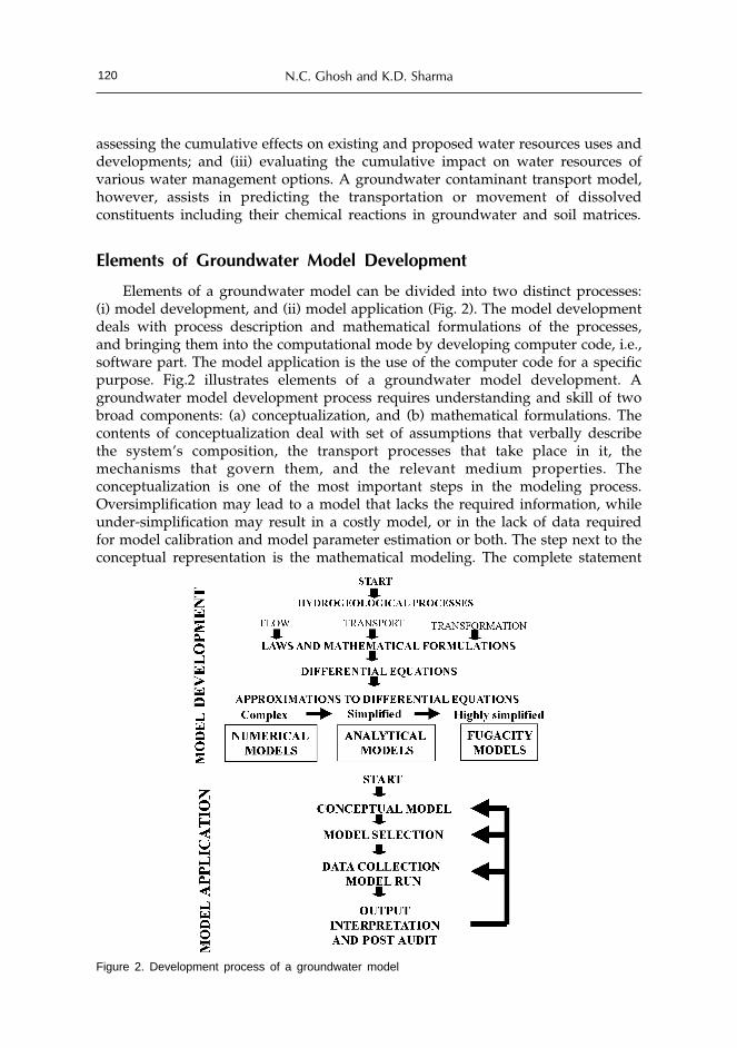
N.C. Ghosh and K.D. Sharma120
assessing the cumulative effects on existing and proposed water resources uses anddevelopments; and (iii) evaluating the cumulative impact on water resources ofvarious water management options. A groundwater contaminant transport model,however, assists in predicting the transportation or movement of dissolvedconstituents including their chemical reactions in groundwater and soil matrices.
Elements of Groundwater Model Development
Elements of a groundwater model can be divided into two distinct processes:(i) model development, and (ii) model application (Fig. 2). The model developmentdeals with process description and mathematical formulations of the processes,and bringing them into the computational mode by developing computer code, i.e.,software part. The model application is the use of the computer code for a specificpurpose. Fig.2 illustrates elements of a groundwater model development. Agroundwater model development process requires understanding and skill of twobroad components: (a) conceptualization, and (b) mathematical formulations. Thecontents of conceptualization deal with set of assumptions that verbally describethe system’s composition, the transport processes that take place in it, themechanisms that govern them, and the relevant medium properties. Theconceptualization is one of the most important steps in the modeling process.Oversimplification may lead to a model that lacks the required information, whileunder-simplification may result in a costly model, or in the lack of data requiredfor model calibration and model parameter estimation or both. The step next to theconceptual representation is the mathematical modeling. The complete statement
Figure 2. Development process of a groundwater model

Groundwater Models 121
of a mathematical model consists of: (i) a definition of the geometry and itsboundaries, (ii) an equation (or equations) expressing the water balance, (iii) fluxequations that relate the fluxes, (iv) constitutive equations that define the behaviorof the fluids and solids involved, (v) an equation (or equations) that expressesinitial conditions, (vi) an equation (or equations) that defines boundary conditionsdescribing interaction with its surrounding environment. The solution to themathematical equations yield the required predictions of the real-world system’sbehavior in response to various sources and/or sinks. The mathematical modelcontains the same information as the conceptual one, but expressed as a set ofequations which are amenable to analytical and numerical solutions. All themathematical equations are expressed in terms of the dependent variables, and thenumber of equations included in the model must be equal to the number ofdependent variables.
Groundwater Modeling
Modeling is not just about entering data into existing modeling packages andreporting results. Development of the groundwater model for a real world and itsapplication requires thorough understanding of the groundwater system forrefinement of the conceptualized elements to maximize knowledge about currentstate of groundwater body and the possible future impacts of proposed development.Groundwater models are used as tool for the assessment of the resource potentialand prediction of future impact under different circumstances/stresses. Predictivecapacity of a model makes it the most useful tool for planning, design,implementation and management of the groundwater resources. Groundwatermodeling provides the framework to decide and predict the fate of decisionvariables of the hydro-geological processes in response to the stresses and/or sinksacting on the system.
The very first step in the modeling process is the construction of a conceptualmodel. Selecting the appropriate conceptual model for a given problem is one ofthe most important steps in the modeling process. The selection of an appropriateconceptual model and its degree of simplification depends on:
• Objective of the management problem,
• Available resources
• Available field data
• Users and beneficiaries attitude to the use of water,
• Legal and regulatory framework applicable to the situations.
The next step in the modeling process is to express or to bring the conceptualmodel in the form of a computational framework. Existing software packages ormathematical equations can be used as computation tools. Fig. 3 illustrates a simplediagram of a model application process (Bear et al., 1992).
A successful model application requires appropriate site characterization andexpert insight into the modeling process. No model can be used for predicting thebehavior of a system unless the numerical values of its parameters have beendetermined by some identification procedure. Because of the simplifyingassumptions embedded in the mathematical equations and the many uncertainties

N.C. Ghosh and K.D. Sharma122
in the values of data required by the model, a model must be viewed as anapproximation and not an exact duplication of field conditions.
Modeling Equations
Groundwater flow and solute transport are governed by the principles ofconservation of momentum and mass. Mathematically, these conservation principles,together with empirical laws can be expressed as a set of partial differentialequations. Subject to initial and boundary conditions as well as appropriate sourcefunctions, the equations can be solved analytically or numerically to interpretobservations or predict certain phenomena.
The modeling equations basically originate from water balance or mass balanceof flow and contaminant transport in porous medium domains. A number ofsimplifying assumptions are usually made before any of these equations arewritten. The well-known Darcy’s law can be derived from simplified assumptionsof momentum balance equation.
Groundwater Flow Equation
The generalized groundwater flow equation for a 3-Dimensional saturatedflow in porous medium is written as (Bear, 1972; Bear, 1979):
Figure 3. Model application process (Source: Bear et al., 1992)

Groundwater Models 123
(2)
where So is the specific storativity of porous medium, φ is the piezometric head,
K is the hydraulic conductivity tensor, Q is the volumetric flux per unit volumerepresenting source/sink term, and ∇ is the vector operation in the xyz plane.
The specific storativity, So, is defined as the volume of water added to storage
in a unit volume of porous medium, per unit rise of piezometer head. Hence, lefthand side of equation (2) expresses the volume of water added to storage in theporous medium domain, per unit volume of porous medium per unit time. Thedivergence of flux vector, q (= - K *Ñf) expresses the excess of outflow over theinflow per unit area, per unit time. In equation (2), the operators are in the threedimensional space. The variable to be solved is f (x,y,z, t). Thus, equation (2) statesthat the excess of inflow over outflow of water in a unit volume of porous medium,per unit time, at a point, is equal to the rate at which water volume is stored.
The generalized groundwater flow equation for a 2-dimensional saturated flowin confined aquifer is written as (Bear, 1972; Bear, 1979):
(3)
where S is the aquifer storativity, φ is the piezometric head, T is the aquifertransmissivity tensor, Ñ is the vector operation in the xy plane, P(x,y,t) is the rateof pumping (per unit area of aquifer), and R(x,y,t) is the rate of recharge (per unitarea of aquifer).
The storativity, S, is defined as the volume of water added to storage in a unitarea of aquifer, per unit rise of piezometer head. Hence, left hand side of equation(3) expresses the volume of water added to storage in the aquifer, per unit volumeof porous medium per unit time. The divergence of flux vector, q (= - T *Ñf)expresses the excess of outflow over the inflow per unit area,per unit time. Inequation (3), the operators are in the two dimensional horizontal coordinates, andthe variable to be solved is f (x,y, t). Thus, equation (3) states that the excess ofinflow over outflow of water in a unit area of an aquifer, per unit time, at a point,is equal to the rate at which water volume is stored.
The governing equation for 3-dimensional density–dependent miscible flowuses for a coastal aquifer may be written as (Guo and Langevin, 2002):
(4)
in which ρ is the variable fluid density; ‘ρ is the density of water entering froma source or leaving through a sink; n is the porosity; Q is the volumetric flow perunit volume of aquifer representing sources/sinks; q is the specific dischargevector, with its component given by:
(5)
μ being the dynamic viscosity; g being the acceleration due to gravity; K beingthe hydraulic conductivity tensor.

N.C. Ghosh and K.D. Sharma124
Contaminant Transport Equation
The generalized contaminant transport equation for a 3-dimensional saturatedflow in porous medium is written as (Bear, 1972; Bear and Bachmat, 1984; Bear andVerrrujit, 1987):
(6)
where C is the concentration of considered contaminant, n is the porosity ofporous medium, q is the specific discharge of water (= volume of water passingthrough a unit area of porous medium per unit time), J* is the diffusive flux ofcontaminant per unit area of fluid in micro-scale, J is the diffusive flux ofcontaminant per unit area of fluid in macro-scale, R
c is strength of contaminant
source (added quantity per unit volume of porous medium per unit time), and Rk
is the chemical reaction term.The transport equation is linked to the flow equation, as:
(7)
The left hand side of equation (6) expresses the mass of the contaminant addedto storage per unit volume of porous medium per unit time, while the first termon the right hand side of equation (6) expresses the excess of the contaminant’sinflow over outflow, per unit volume of porous medium, per unit time. The secondand third terms on the right side of equation (6) express respectively the addedmass of various sources and the chemical reaction component. The total flux ismade up of an advective flux with fluid, a diffusive flux, and a dispersive flux. Thediffusive and dispersive fluxex appearing in equation (6) are expressed in terms ofthe concentration, C, as:
(8)
where Dm is the coefficient of molecular diffusion in a porous medium, and D
is the coefficient of dispersion.The governing equation for 3-dimensional variable density transport equation
can be expressed in the same way as equation (6) but the density can be writtenby an empirical equation as a function of concentration suggested by Baxter andWallace (1916):
(9)
in which, E is a dimensionless constant, approximately value of 0.7143 for saltconcentrations ranging from zero for freshwater to 35 kg/m3 for seawater and ρ
f
is the fluid density of freshwater.
Model Coefficients and their Estimation
In describing movement from microscopic level to macroscopic level, variouscoefficients of transport and storage are introduced. The permeability of porousmedium, aquifer transmissivity, aquifer storativity, and porous medium dispersivityare examples of model coefficients. Permeability and dispersivity are examples of

Groundwater Models 125
coefficients that express the macroscopic effects of microscopic configuration of thesolid-fluid interfaces of a porous medium. The coefficients of aquifer storativityand transmissivity are introduced by the further averaging of the three-dimensionalmacroscopic model over the thickness of an aquifer in order to obtain a two-dimensional model. All these coefficients are coefficients of the models, and theirinterpretation and actual values may differ from one model to the next. Theactivity of identifying these model coefficients is often referred to as the identificationproblem.
The values of the coefficients for a considered model are obtained byinvestigating the available data of real-world aquifer system on: (i) initial conditionsof the system; (ii) excitations of the system, as in the form of pumping and artificialrecharge and changes in boundary conditions; and (iii) observations of the responseof the system, as in the form of temporal and spatial distributions of water levelsand solute concentrations. Various techniques exist for determining the “best” or“optimal” values of the coefficients. Some techniques use the basic trial-and-errormethod, while others employ more sophisticated optimization methods. In somemethods, a priori estimates of the coefficients, as well as information about lowerand upper bounds, are introduced. Beside these, another unique method, calledinverse problem, is also used to determine the model coefficients.
Methods of Solution
Once a well-posed model for a given problem has been constructed, includingthe numerical values of all the model coefficients, it must be solved for any givenset of excitations (i.e., initial and boundary conditions, sources and sinks). Thepreferable method of solution is the analytical one, however, for most cases ofpractical interest, this method of solution is not possible due to the irregularity ofthe domain’s shape, the heterogeneity of the domain with respect to variouscoefficients, and various non-linearities. Instead, numerical models are employed.
As a numerical model is derived from the mathematical equations andinterpretations, it need not necessarily be considered as the numerical method, butas a model of the problem in its own right. With the introduction of computers andtheir application in the solution of numerical models, solutions of complex ground-water problems have become relatively easy.
Analytical Models
Such models enable investigators to conduct a rapid preliminary analysis ofgroundwater contamination and to perform sensitivity analysis. A number ofsimplifying assumptions regarding groundwater system are necessary to obtain ananalytical solution. For application and analyzing an analytical model in context tothe “real-life” problem, it requires sound professional judgment and experience.Analytical models should be viewed as a useful complement to numerical models.

N.C. Ghosh and K.D. Sharma126
Numerical Models
Depending on the numerical technique(s) employed in solving the mathematicalmodel, there exist several types of numerical models:• Finite-difference models• Finite-element models• Boundary-element models• Particle tracking models
- Method of characteristics models- Random walk models, and
• Integrated finite difference models.The main features of the various numerical models are:
• The solution is sought for the numerical values of state variables only atspecified points in the space and time domains.
• The partial differential equations replaced by a set of algebraic equationswritten in terms of discrete values of the state variables at the discrete pointsin space and time.
• The solution is obtained for a specified set of numerical values of the variousmodel coefficients.
• Because of the large number of equations, which are to be solved simultaneously,a computer program is prepared.In the present global computational environment, software codes of almost for
all classes of problems encountered in the management of groundwater areavailable. Some codes are very comprehensive, popular and widely used, such as;MODFLOW & MT3D (Modular Three-Dimensional Finite-Difference GroundwaterFlow Model) developed by U.S. Geological Survey (McDonald and Harbaugh,1988) and associated modules; MODPATH, RT3D; GMS (Groundwater ModelingEnvironment for MODFLOW, MODPATH, MT3D, RT3D, FEMWATER, SEAM3D,SEEP2D, PEST, UTCHEM, and UCODE); FEFLOW (Finite Element Sub-surfaceFlow System); Groundwater Vistas (Model Design and Analysis for MODFLOW,MODPATH, MT3D, RT3D, PEST, and UCODE); HST3D (3-Dimensional Heat andSolute Transport Model); SEWAT(Density Driven flow and transport model);SUTRA (2-Dimensional Saturated/ Unsaturated Transport Model) etc. The strengthand computational competency of these models are well recognized amongst thegroundwater modelers.
Groundwater Resource Management Model
Management of groundwater resources primarily involves the allocation ofgroundwater supplies in terms of quantity and quality to competing demands.Groundwater models are utilized to explore groundwater management alternatives.A groundwater management model is the combination of groundwater simulationmodels and the optimization methods, which are coupled together to produce asingle program to optimize management objectives while meeting physical andtechnical constraints on groundwater behavior. The optimization scheme is themathematical transformation of management objectives (e.g., maximize benefits oreffectiveness, or, minimize cost) or design criteria and the physical constraints. In

Groundwater Models 127
a groundwater system, management decisions may be related to rates and locationof pumping and artificial recharge, changes in water quality, location and pumpingin pump-and treat operations, etc. The resulting optimization problem is thensolved to determine the optimal strategy for dealing with the management objectivesand design criteria. However, the value of management’s objective function usuallydepends on both the variables and on the response of the aquifer system. Constrainsare expressed in terms of future values of state variables of the consideredgroundwater system. An essential part of a good decision-making process is thatthe response of a system to the implementation of contemplated decisions must beknown before they are implemented.
Optimization modeling involves the development of a systematic method ofdetermining optimum water supply strategies that would satisfy variousenvironmental and hydrologic requirements. The purpose of this type of watersupply strategy is to balance the projected needs against available sources. Althoughthe simulation models provide the resource planner with important tools formanaging the groundwater system, the prediction tools don’t identify the optimalgroundwater development, design and operation policies for an aquifer system. Incontrast, groundwater optimization models identify the optimal planning or designalternatives in the context of the system objectives and constraints. It is thegroundwater planners or the decision makers, who has to decide the best amongthe possible alternatives. Fig.4 represents a generalized structure of a simpleSimulation-Optimization framework. Structurally, the coupled Simulation-Optimization (S/O) models have an optimizer linked to an external simulator. TheS/O approach is appealing because it can readily use existing simulation modelsand can account for the nonlinear and complex behavior of a groundwater flowsystem.
Both linear and non-linear optimization techniques are used to developgroundwater management models. Simplex method for linear problems, sequentiallinear programming for nonlinear problems, and branch and bound algorithm formixed integer problems are some conventional techniques of optimization. Besidesthose, the other advanced techniques developed in recent time for optimization ofgroundwater quantity and quality management strategies, and also for remediationare: (i) nonlinear chance-constrained groundwater management model (Tung,1986; Wagner and Gorelik, 1987; Gailey and Gorelik, 1993; Tiedman and Gorelik,1993), (ii) simulated annealing method (Dougherty and Marryott, 1991), (iii) Sharpinterface model for seawater intrusion (Finney et al., 1992), (iv) simulation-optimization model for well field, capture zone design, groundwater levelspredictions for pumping policy, supply-demand scheduling, etc (Varlein andShafer, 1993; Chau, 1992; Danskil and Freckleton, 1992; Lall and Lin, 1993; Gharbiand Peralta, 1994). The method of optimization is another subject, which requiresa separate discussion and is not included in the scope of the paper.
Need of Groundwater Management Models
Management problems of groundwater resources primarily deal with threeaspects: (i) supply-side components (availability and distribution), (ii) demand-sidecomponents (allocations for different requirements), and (iii) impinging components

N.C. Ghosh and K.D. Sharma128
(threat to the availability). The supply-side and demand-side components mostlydeal with quantitative aspect, while the impinging issues could be of bothquantitative and qualitative form of the groundwater system. Impinging orencroaching issues mainly indulge into the prospect of availability and demand aswell. To exemplify the components of exploitations and their consequences withthe components of availability, let us look into the schematized Fig.5; in whichsome of the key issues of supply, demand and impinge components are depicted,which are self explanatory. The supply-side components are those, which createpositive potential to the storage (i.e., increases the storage volume), the demand-side components are those, which withdraw water from storage (or, reduce thestorage potential), while the impinging components have the characteristics ofdefunct and reduce of the potential of storage. Causes and factors responsible tothese issues are also illustrated in the figure. To the supply-side, recharge fromrainfall and irrigation application, and seepage from surface interactions are themain components of supply of water to the groundwater system, while all otherfactors (such as, permeability, hydrogeology, aquifer properties, etc) give shape tothe availability and distribution of flow in space and time. The rainfall rechargeand the seepage from surface waters depend largely on the rainfall, whosedistributions also vary on space and time, but by and large, the fluctuation of
Figure 4. A generalized structure of a simple simulation-optimization framework

Groundwater Models 129
average annual rainfall between years at a specific location is very less exceptsevere years. Thus, recharge area remaining same; the supply of replenishablegroundwater resources in an area does not change much over the years but turnsinto a limiting state.
The demand-side constitutes all those components, which are driven mainly bythe population expansion and associated demands, food security, socio-economicdevelopment and regulatory provisions, etc. Unlike the characteristics of supply-side components, the characteristics of demand-side components vary in magnitudebetween years besides spatial variation. It is the multidimensional demands includingtheir increase over time, which brings susceptibility to the supply-side. Multipledemands supported by limited supply eventually suggest for requirement ofmanagement decisions for operation of the system.
Impinge on the availability resulting from the exploitations of the demand-sideappends threat in terms of quality and quantity both on time and space to theexisting storage and to the future storage. These unfavorable factors originate frompollution due to solid and liquid waste disposal, refusal of agricultural waste,septic tank leakages, change of oxidation-reduction potential in hydro-geologicalenvironment due to overexploitation of groundwater, seawater intrusion, influenceof saline and sodic soils to the groundwater, etc., while others, such as, encroachto the recharge zones, land-use changes, etc, are due to the socio-economic andsocio-cultural development of the society. Economic development side by side
Figure 5. Supply-Demand-Encroachment components of an exploited groundwater resource system

N.C. Ghosh and K.D. Sharma130
increasing health awareness are giving rise to problems of right to use ofgroundwater, and permit to stakeholders for use of groundwater. Conflict insharing of groundwater of a common pool is another emerging problem.Management of coastal aquifers against threat of saline water ingress requiresspecial skill and attention. Groundwater contamination and its mobilization andspreading in the soil pores and in the groundwater are emerging as gigantic issuesother than the groundwater flow management. Vulnerability of contamination tothe freshwater zones of a contaminated aquifer would increase if the contaminatedaquifers remain untreated. Aquifer restoration and remediation are, therefore,needed to ensure the risk free replenished groundwater. The management decisionscannot be prejudiced to quantity without assuring the quality of water beingsupplied. These multi-faceted complexities insist upon to develop appropriatedecision support system for management of groundwater system.
The purpose of the groundwater resource management model being determiningthe optimal allocation strategy against demands under the constrains of availabilityand supply or with some limiting conditions either to the supply-side or to thedemand-side, it is essentially required to recognize and understand the characteristicsand behavior of associated components. The characteristics and behavior ofcomponents of a system can be described when their physical realism are understoodto the possible extent. More is the understanding of the hydrological and hydro-geological processes better is the prospect of conceptualize framework of themodels. Figure 6 depicts some of the key issues and factors, which are to beaddressed for achieving the goal of groundwater resource management.
Finally, a management approach is said to be perfect, if the demand-sideelements balance with its supply-side inputs. In case of groundwater management,the elements are: (i) hydrogeologic and socio-economic conditions of the system,(ii) regulatory interventions, (iii) regulatory provisions, and (iv)costs and benefitsof management activities and interventions. Figs.7 and 8 depicts how a supply
Figure 6. Key issues of policy planning and decisions of groundwater resource management

Groundwater Models 131
Figure 8. Integrated groundwater resourcemanagement – leading to a virtuous circle(Source : GW-MATE, 2004)
Figure 7. Supply-driven groundwaterdevelopment – leading to a vicious circle(Source: GW-MATE, 2004)
driven ‘vicious circle’ of groundwater development can be transformed into a‘virtuous circle’ of integrated groundwater resource management through integrationof supply-side management with the demand-side management.
Concluding Remarks
Models are conceptual framework of physical systems represented by well-posed mathematical equations derived from the physical laws that the system mustobey. Models are used to bring quantitative data and qualitative informationtogether in a predictive framework, and hence can be regarded as tools in insightthe behavior of a system in response to imposed stresses/strains without interveningphysically into the system.
Groundwater models are simplified versions of a conceptualized groundwatersystem that approximately simulates the relevant excitation-response relations ofthe system. Being a simplified version of real-world system, no model is unique toa given system. Groundwater models are one of the management tools used for theassessment of the resource potential and prediction of future impact under differentcircumstances. Predictive capacity of a model makes it the most useful tool forplanning, design, implementation and management of the groundwater resources.
Groundwater management model is a coupled framework of the groundwatersimulation models and the optimization methods that produces a single programto optimize management objectives while meeting physical and technical constraintson groundwater behavior. It is simulation models, which actually impart science ofhydrological and hydro-geological processes into the management approaches.Optimization method has its own mathematical authenticity. These facts bringstrength to the genuineness of a groundwater management model.
Increasing pace of multidimensional demands pulled by the limiting state ofsupply and pollution threats direct only towards development and use of bestmanagement approach.

N.C. Ghosh and K.D. Sharma132
References
Ahlfeld, D.P. and Heidari, M. 1994. Applications of optimal hydraulic control to groundwater systems,Jour. Water Resour. Plan and Manag., ASCE, 120(3): 350-365.
Andricevic, R., and Kitanidis, P.K. 1990 Optimization of the pumping schedule in aquifer remediationunder uncertainties, Water Resour. Res., 26(5): 875-885.
Baxter, G.P. and Wallace, C.C. 1916. Changes in volume upon solution in water of halogen salts of alkalimetals, Jour. Am. Chem. Soc., 38: 70-104.
Bear, Jacob. 1972. Dynamics of fluids in porous media, American Elsevier, New York.
Bear, Jacob. 1979. Hydraulics of groundwater, McGraw-Hill, New York.
Bear, Jacob and Bachmat, Y. 1984. Transport phenomena in porous media-basic equations, in J. Bear andM.Y. Corapcioglu (eds.), Fundamentals of Transport Phenomena in Porous Media, Martinus,Nihhoff, Dordrecht, pp.3-61.
Bear, Jacob, and Verruijit, Arnold. 1987. Modeling groundwater flow and pollution, D. Reidel PublishingCompany of Kluwer Academic Publishing Group, Holland, 414p.
Bear, Jacob, Beljin, Milovan S. and Ross, Randall R. 1992. Fundamentals of groundwater modeling, EPA-Groundwater Issue, US-EPA, Solid Waste and Energy Response, Report no. EPA/540/S-92/005.
Beck, A.E., Garven, G. and Stegena, L. (Ed.). 1989. Hydrogeological regimes and their subsurfacethermal effects, Am. Geophysical Union Monograph 47.
Bredehoeft, J.D., and Pinder, G.F. 1973. Mass transport in flowing groundwater, Water Resour. Res.,9(1): 194-210.
Clearly, R.W. and Ungs, M.J. 1978. Analytical models for groundwater pollution and hydrology,Princeton University, Water Resour. Program, Report 78-WR-15.
Carslaws, H.S. and Jaeger, J.C. 1959. Conduction of heat in solids, 2nd ed., Oxford Press, New York.
Chau, T.S. 1992. Optimal management of relief wells near Waterton reservoir, Water Resour. Bulletin,28(2): 349-360.
Custodio, E. and Dijon, R. 1991. Groundwater overexploitation in developing countries, UN Inter-regional Workshop report, UN-INT/90/R43: New York, USA.
Danskin, W.R. and Freckleton, J.R. 1992. Groundwater flow modeling and optimization techniquesapplied to high groundwater problems in San Bernardino, California, in selected papers in thehydrological science, S. Subitzky (ed.), US Geol. Sur. Water-Supply Paper No. 2340, pp.165-177.
De Marsily, G. 1868. Quantitative hydrogeology, Academic Press, San Diego, USA.
Domenicp, P.A. and Schwartz, F.R. 1998. Physical and chemical hydrogeology, 2nd ed., John Wiley andSons, New York.
Dougherty, D.E., and Marryott, R.A. 1993. Optimal groundwater management 1. Simulated Annealing,Water Resour. Res., 30(3): 107-114.
Freeze, R.A. and Cherry, J.A. 1979. Groundwater, Prentice-Hall, Inc., Engle-wood Cliffs.
Goldberg, D.E. 1989. Genetic algorithms in search, optimization and machine learning, 412p., Addison-Wesley, New York.
Gorelick, S.M. 1983. A review of distributed parameter groundwater management modeling methods,Water Resour. Res., 19(2): 305-319, 1983.
GW-MATE. 2004.Briefing Note Series, on Sustainable Groundwater Management: Concepts and Tools,World Bank, Global Water Partnership Associate Program.
Hunt, B. 1983. Mathematical analysis of groundwater resources, Butterworths, Boston.
Huyakorn, P.S. and Pinder, G.F. 1983. Computational methods in subsurface flow, Academic Press, SanDiego.
International Water Management Institute (IWMI). 2001. Overview: Sustainable groundwatermanagement, Research Theme: Groundwater, Sri Lanka.
Karatzas, G.P. and Pinder, G.F. 1993. Groundwater management using numerical simulation and theouter approximation method for global optimization, Water Resour. Res., 29(10): 3371-3378.
Lall, U. and Lin, Y.W.H. 1991. A groundwater management model for Salt Lake County, Utah withsome water rights and water quality considerations, Jour. of Hydrol. 123: 367-393.
Majumdar, P.K., Ghosh, N.C. and Chakravorty, B. 2002. Analysis of arsenic-contaminated groundwaterdomain in the Nadia district of West Bengal, Jour. Hydrol. Sciences, Special Issue: TowardsIntegrated Water Resources Management for Sustainable Development, 47(S): S55-S66.

Groundwater Models 133
McKinney, D.C., and Lin, M.D. 1994. Genetic algorithm solution of groundwater management models,Water Resour. Res., 30(6): 1897-1906.
Moore, J.E. 1979. Contribution of groundwater modeling to planning, Jour. of Hydrol., 43: 121-128.Simpson, P.K. 1990. Artificial Neural Systems: Foundations, Paradigms, Applications, and
Implementations, 209p., Pergamon, New York.Sun, N.Z. 1994. Inverse problems in groundwater modeling, Kluwer Academic Publishers, Boston.Tucciarelli, T., and Pinder, G. 1991. Optimal data acquisition strategy for the development of a transport
model for groundwater remediation, Water Resour. Res., 27(4): 577-588.Tuinhop, Albert, Charles Dumars, and Stephen Foster.2004. Briefing Note 1 : Groundwater Resource
Management – an introduction to its scope and practice, GW-MATE Briefing Note Series, onSustainable Groundwater Management: Concepts and Tools, World Bank, Global WaterPartnership Associate Program.
Tung, Y. 1986. Groundwater management by chance-constrained model, Jour. Water Resour. Plan.Manag., ASCE, 112(1): 1-19.
Varljen, M.D. and Shafer, J.M. 1993. Coupled simulation-optimization modeling for municipalgroundwater supply protection, Ground Water, 31(3): 401-409.
Wagner, B.J. and Gorelick, S.M. 1987. Optimal groundwater quality management under uncertainty,Water Resour. Res., 23(7): 1162-1174.
Wang, W., and Ahlfed, D.P. 1994. Optimal groundwater remediation with well location as a decisionvariable: Model development, Water Resour. Res., 30(5): 1605-1618.
Wandschneider, Philip, and James C. Barron.1993. Economic issues in protecting groundwater quality,Washington State Department of Ecology, Subject codes 376, 320. A, EB1751, Washington StateUniversity, USA.
World Bank.1998. India-water resources management sector review-Groundwater Regulation andManagement Report, pp.1-98.
Yeh, W. W.G.1992. Systems analysis in groundwater planning and management, Jour. Water Rosour.Plan. and Manag., ASCE, 118(3): 224-237.

Watershed Management and Water Harvesting asStrategic Tools for Groundwater Augmentation
V.N. ShardaCentral Soil & Water Conservation Research and Training Institute,
Dehradun, India
Abstract
The conservation, development and management of water are pivotal to the concept of‘watershed management’. Watershed management envisages a systematic and scientificapproach towards conservation, harvesting, proper utilization and safe disposal of flowingwater from the moment it strikes the land surface as a tiny drop till it joins the ocean foroptimum production on sustained basis. After the successful implementation of OperationalResearch Projects by Central Soil & Water Conservation Research & Training Institute,Dehradun in 1970’s, the Government of India launched a massive National WatershedDevelopment Programme for Rainfed Areas in 1991. Many other programms funded bynational and international agencies followed this. By the end of IXth Five Year Plan, anexpenditure of INR 92.7 billion has been incurred in watershed programes by theMinistries of Agriculture and Rural Development covering an area of 29M ha. By the endof XIIIth Plan, it is envisaged to cover an area of 88.5M ha under watershed developmentprograms at an estimated cost of INR 727.50 billion. With the shift in paradigms,participatory watershed management ensuring transparency and equitable sharing ofresources and benefits among different stakeholders is being emphasized. Thus, watershedbased development has been accepted as a single-window strategy for harmonizingsimultaneously joint management of land, water, vegetation and human resources forsustainable productivity.
Water harvesting and its utilization is one of the major components of the watersheddevelopment programs which is realized through: (a) in-situ rain water harvestingmeasures, (b) surface water development measures, such as ponds, earthen reservoirs, smallharvesting tanks, gully control structures and, drainage line treatments (c) sub-surface orground water development measures such as percolation tanks, ponds, sub-surface dams,barriers, and, diaphragm dams (d) roof top collection and runoff water cistern and, (e)improved water management practices including micro-irrigation and on-farm watermanagement. It has been estimated that about 24M ha-m rainwater can be harvested intowater storage structures, of which one fourth can be harvested into ponds and percolationtanks in rainfall zone upto 1000 mm/annum. This runoff water can provide life savingirrigation of 5 cm each for more than 60-percent of the rainfed area in the country. Apartfrom providing water storage for supplementary irrigation, the integrated watershed

Strategic Tools for Groundwater Augmentation 135
development programs help in moderating the floods in down stream areas and improve in-situ moisture conservation for increased biomass production. Besides, ground waterrecharge and rise in water table up to 2-meter height due to integrated watershedmanagement were experienced in different regions of India with tremendous environmentalexternalities.
With an investment of INR 92.7 billion during IXth Plan, an additional area of40,299 ha was brought under irrigation and most of the dug wells and tube wells have beenrejuvenated with round the year water availability. However, the effect of water harvestingstructures on ground water recharge has not been properly understood except by employingcrude methods of studying rise and fall in water table of open or tube wells in differentregions. A core project to analyze the relationships between water harvesting structuresand ground water recharge in different agro-ecological situations has been initiatedrecently by CSWCRTI, Dehra Dun. The preliminary results in one of the watersheds atAntisar in Kheda district of Gujarat have shown that about 6.5 percent of the annualrainfall is effective in recharging the ground water aquifer. It was further observed that aminimum of 103.6 mm runoff is needed to trigger 1.0 mm of potential recharge in thisagro-climatic setting. The results were obtained by employing water table fluctuation andchloride mass balance methods, which need further investigations and comparison withother modern tools and techniques for arriving at logical conclusions.
Introduction
Why does water-harvesting matter more today than any other time? There areseveral reasons (Jackson et al., 2001): (1) over half of the accessible freshwaterrunoff globally is already appropriated for human use; (2) more than one billionpeople currently lack access to clean drinking water and almost three billion peoplelack basic sanitation services; (3) because the human population will grow fasterthan increase in the amount of accessible freshwater, per capita availability offreshwater will decrease in the coming century; (4) climate change will cause ageneral intensification of the earth’s hydrological cycle in the next 100 years, withincreased precipitation, evapo-transpiration, occurrence of storms and significantchanges in bio-geochemical processes influencing water quality. Human societynow uses 26% of the total terrestrial evapotranspiration and 54% of the runoff thatis geographically and temporally accessible. New dam constructions could increaseaccessible runoff by about 10% over the next 30 years, whereas the population isprojected to increase by more than 45% during that period (Postel et al., 1996).Under such circumstances, in-situ rainwater harvesting shall be crucial.
As summers get hotter, and anthropogenic climate changes exert further strainon socio-economic and natural systems, water scarcity is likely to grow in regionssuch as South Asia and elsewhere. Addressing water problem holds the promisein future for a world compounded by climate change, growing population, anddecreasing water-impounding area of traditional tanks due to urban and industrialsettlements. In addition, extreme bio-climatic events are registering a monotonicallyincreasing trend. A significant proportion of the global land area has beenincreasingly affected by a significant change in climatic extremes in the recent past.

V.N. Sharda136
A recent study projected, that in India, winter rainfall may decline by 5 to 25%and may lead to droughts during the dry summer months in coming decades (Lalet al., 2001). Thus, we will have to take into account the large-scale, natural climatevariations as well as human-induced climate change in the management of natural,social and economic systems. If extreme climate events increase in future due toclimate change, human society will use different means of adaptation. Additionally,regardless of climate fluctuations, population growth will put extra stress onnatural resources. Alternative to ecologically damaging, socially intrusive, andcapital-intensive water management projects that fail to deliver their desiredbenefits, it would be useful to invest in decentralized facilities, efficient technologiesand policies, and human capital to improve overall productivity rather than to findnew sources of water supply. Such efforts would need to be encouraged withinnovative policy regimes that concurrently promote rainwater harvesting.Traditionally, such systems have been integrated with agro-forestry and ethno-forestry practices, and remain useful in contemporary conservation and ecologicalrestoration of degraded ecosystems (Pandey, 2002). A systematic support to localinnovations on rainwater harvesting could provide substantial amounts of water.Simple indigenously adapted techniques such as ponds and earthen embankmentscan help in harvesting and storage of rainwater. Rural and urban water use,restoration of streams for recreation, freshwater fisheries, and protection of naturalecosystems are all competing for water resources earlier dedicated only to foodproduction. Decentralized rainwater harvesting adaptations (Figure 1) thereforebecome crucial for meeting the competing needs for water. For instance, in theNegev Desert, decentralized harvesting of rainwater in micro-catchments from rainfalling over a 1-ha watershed yielded 95,000 litres of water per hectare per year,whereas collection efforts from a single large unit of a 345 ha watershed yieldedonly 24,000 litres per hectare per year (Pandey, 2001). Thus, 75% of the collectiblewater was lost as a result of the longer distance of runoff.
Figure 1. Schematic of types of rainwater harvesting adaptation (a) case of single structure at the remoteoutlet, (b) decentralized water harvesting structure based adaptations
(a) (b)

Strategic Tools for Groundwater Augmentation 137
Traditional systems would become more efficient if scientific attempts arecombined to enhance productivity of local knowledge. But some local technologiesmay already be at par with scientific attempts. Rainwater harvesting also has greatpotential as a solution to mitigate wide spread arsenic poisoning (Mandal et al1996). In West Bengal and Bangladesh, alluvial Ganges aquifers used for publicwater supply are polluted with naturally occurring arsenic, which adversely affectsthe health of millions of people by causing arsenicosis (Pandey et al., 1999) andincreasing the risk of cancer. Millions of people are at risk in Bangladesh alone(Dhar et al., 1997). Arsenic mobilization is associated with the advent of massiveirrigation pumping that draws relatively young water directly into the aquifer(Harvey et al., 2002). Deep wells are being advocated as a remedy, that mayprovide a source of clean water; but the solution is only a provisional one.Rainwater harvesting is a better option to provide arsenic-free, safe water in a cost-effective and accessible manner, particularly for drinking and food preparation.We must, however, address several challenges to make rainwater harvestingefficient, particularly treatment of harvested rainwater in areas where pollution isrampant (Naik et al., 2002).
Water Harvesting and Integrated Watershed Management
Rainwater harvesting can be promoted as a core adaptation strategy forachieving the global security and sustainability of water resources in an era ofanthropogenic climate change. However, this requires an insightful policy. Overthousands of years, people living in various geographical and climatic regions ofthe world have evolved diverse, indigenous rainwater harvesting and managementregimes as an adaptation to climate change. Some of these practices continue toremain in use, particularly in South Asia. Rainwater harvesting in South Asiadiffers from that in many parts of the world – it has a history of continuous practicefor at least the last 8000 years (Pandey et al., 2003). Water has been harvested inIndia since antiquity, with our ancestors perfecting the art of water management.Many water harvesting structures and water conveyance systems specific to theeco-regions and culture has been developed. Civil society institutions andgovernment agencies are increasingly taking up water harvesting projects in ruralareas. There are several initiatives where the traditional water harvesting practiceshave been modified depending upon the domestic and irrigation needs of the localcommunity. Such improvisations initiated by the communities in different parts ofthe country and eco-region (Figure 2) is more scientifically adaptable. A few ofthem are listed in Table 1.

V.N. Sharda138
Figure 2. Ecological regions of India(Source: http://www.rainwaterharvesting. org/eco/eco-region.htm)
Table 1. Traditional and contemporary water harvesting systems practiced in different agro-ecologicalzones of India
Ecological regions Traditional water harvesting Contemporary waterof India practices harvesting systems
Trans-Himalayan region Zing Artificial glaciersWestern Himalaya Kul,Naula, Kuhl, Khatri —-Eastern Himalaya Apatani —Northeastern hill ranges Zabo, Cheo-oziihi, Bamboo drip irrigation —Brahmaputra valley Dongs, Dungs/jampois —Indo-Gangetic plains Ahars-pynes, Bengal’s Inundation —
channels, Dighis, BaolisThar Desert Kunds/kundis, Kuis/beris, Baoris/bers, Nadis, Polymer Kundis
Jhalaras, Nadi, Tobas, Tankas, Khadins,Vav/Vavdi/Baoli/Bavadi, Virdas, Paar
Central highlands Talab/Bandhis, Saza Kuva, Johads ChaukasNaada/bandh, Pat, Rapat, Chandelatank, Bundela tank
Eastern highlands Katas/Mundas/Bandhas Jaldhar ModelsDeccan plateau Cheruvu, Kohli tanks, Bhandaras, Phad, Tudum/Monga Network-
Kere, The Ramtek Model ing of farm pondsWestern ghats Surangam —Western coastal plains Virdas —Eastern ghats Korambu —Eastern coastal plains EriOoranis Horizontal roughening filters
The Islands Jack Wells —
(Source: http://www.rainwaterharvesting. org/eco/eco-region.htm)
Trans-Himalayan Region
ECOLOGICAL REGIONS OF INDIA
WesternHimalayas
TharDesert
CentralHighlands
WesternCoastal
Plains
WesternGhats
The Island
Eastern CoastalPlains
Eastern Ghats
Deccan Plateau
EasternHighlands
North-EasternHill Ranges
Indo-GangeticPlains
EasternHimalayas
Brahmaputraand
Barak Valley
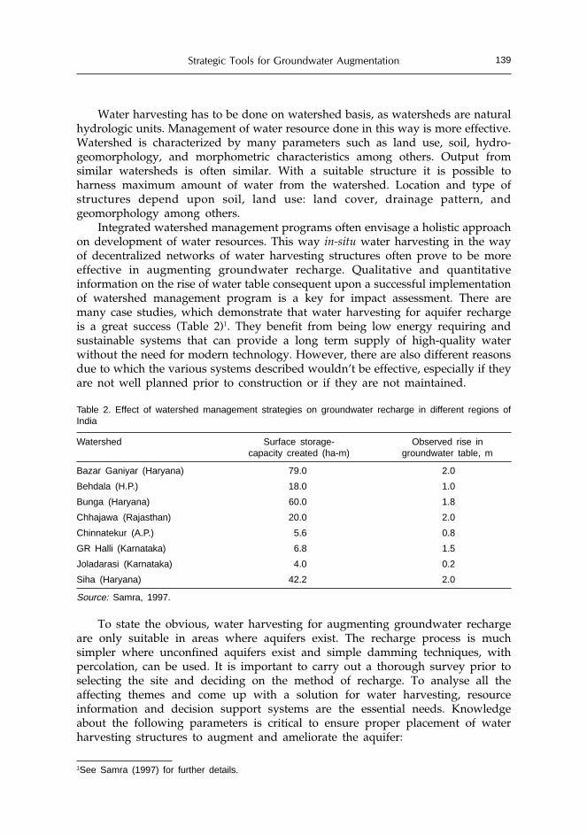
Strategic Tools for Groundwater Augmentation 139
1See Samra (1997) for further details.
Water harvesting has to be done on watershed basis, as watersheds are naturalhydrologic units. Management of water resource done in this way is more effective.Watershed is characterized by many parameters such as land use, soil, hydro-geomorphology, and morphometric characteristics among others. Output fromsimilar watersheds is often similar. With a suitable structure it is possible toharness maximum amount of water from the watershed. Location and type ofstructures depend upon soil, land use: land cover, drainage pattern, andgeomorphology among others.
Integrated watershed management programs often envisage a holistic approachon development of water resources. This way in-situ water harvesting in the wayof decentralized networks of water harvesting structures often prove to be moreeffective in augmenting groundwater recharge. Qualitative and quantitativeinformation on the rise of water table consequent upon a successful implementationof watershed management program is a key for impact assessment. There aremany case studies, which demonstrate that water harvesting for aquifer rechargeis a great success (Table 2)1. They benefit from being low energy requiring andsustainable systems that can provide a long term supply of high-quality waterwithout the need for modern technology. However, there are also different reasonsdue to which the various systems described wouldn’t be effective, especially if theyare not well planned prior to construction or if they are not maintained.
Table 2. Effect of watershed management strategies on groundwater recharge in different regions ofIndia
Watershed Surface storage- Observed rise incapacity created (ha-m) groundwater table, m
Bazar Ganiyar (Haryana) 79.0 2.0
Behdala (H.P.) 18.0 1.0
Bunga (Haryana) 60.0 1.8
Chhajawa (Rajasthan) 20.0 2.0
Chinnatekur (A.P.) 5.6 0.8
GR Halli (Karnataka) 6.8 1.5
Joladarasi (Karnataka) 4.0 0.2
Siha (Haryana) 42.2 2.0
Source: Samra, 1997.
To state the obvious, water harvesting for augmenting groundwater rechargeare only suitable in areas where aquifers exist. The recharge process is muchsimpler where unconfined aquifers exist and simple damming techniques, withpercolation, can be used. It is important to carry out a thorough survey prior toselecting the site and deciding on the method of recharge. To analyse all theaffecting themes and come up with a solution for water harvesting, resourceinformation and decision support systems are the essential needs. Knowledgeabout the following parameters is critical to ensure proper placement of waterharvesting structures to augment and ameliorate the aquifer:

V.N. Sharda140
• climatic records- rainfall, humidity, evaporation rates;• topographical maps including drainage networks and ephemeral streams;• data on soil thickness (types and distribution);• distribution of rock types, especially surface features;• definition of pore networks;• recognition of recharge, discharge areas and the flow direction of the
groundwater.Moreover, series of studies have been conducted world wide to establish both
diagnostic as well as prognostic interaction between the surface and groundwaterprocesses. However, only few studies could address the realistic solution to theimpact of water harvesting structures on groundwater recharge. To address thisissue efforts have been made by CSWCR&TI, Dehradun to formulate a core projecton the field scale monitoring of watersheds implemented under IntegratedWasteland Development Program (IWDP) funded by Ministry of RuralDevelopment, Government of India. The regional centre at Vasad was the firstamong all the cooperating centres, which had initiated this project at Antisar inGujarat. The project has become a classical effort in successful implementation ofwater harvesting technologies for groundwater recharge.
Water Harvesting Experiences: A Case Study (Antisar, Gujarat)
In Antisar a watershed development program was undertaken by focusing onwater harvesting and artificial recharge structures. Antisar is located in Kapadwanjtaluk of Kheda district in Gujarat. The findings from the program shows that thebenefits accrued are worth the capital investments incurred on program activities.Twenty-three (23) artificial recharge filters and 16 check dams were constructed inthe span of five years between 1998 to 2003 (Figure 3). Renovation and deepeningworks with five water-harvesting structures were also carried out. 139 tube wells/open wells have been used to monitor the trend of water table rise or fall duringthe year 2002 and 2003. The salient findings of the studies are as under (Kumar etal., 2004):
Water Table Increase in Influence Zone of Water Harvesting Structures
The incidence of successive drought years (1999-2001) had resulted in reducedwater table situation in the area. Therefore, between 1999-2001 the people in thewatershed could not go for Rabi(winter) crops in a large scale due to early dryingof the wells. Most of the recharge or water harvesting structures were constructedduring the year 2001-2002 under the IWDP program. The influence of waterrecharged from different water harvesting structures such as check dams, rechargefilters and ponds was studied using storage volume fluctuation technique in thearea. It was observed that the average days that the water percolated from pondsand check dams would reach groundwater table in approximately 6 days, whereas for the recharge filters it took one or two days.

Strategic Tools for Groundwater Augmentation 141
The ground water mound under a structure recedes in 15 days to attain adynamic equilibrium with the water table. The influence was found to be higherin the down stream side well of the water harvesting structure with a differentialwater table gain from 3.62 m to 10.66m.
Number of Wells Influenced
Based on the water table data recorded between July 20- August 5, 2004, 101tube wells/open wells (73%) out of the designated 139 tube wells / open wells gotinfluenced by the recharged water. The rainfall during this period was 234 mm.The net rise in water table during this period was 4.99 m.
In the successive fortnight (August 5-20, 2003) there was no rainfall. Therefore,the net rise in water table was 0.69 m, which is due to percolation of water fromwater harvesting structures coupled with internal distribution of water in theaquifer and gradual recession of the mounds formed under different waterconservation structures (check dams, water harvesting ponds or recharge filters).By this time, almost all tube wells and the recharged water influenced open wellsin the watershed. Therefore, it was observed that due to increased water harvestingat strategic positions, a better distribution of water occurs in the watershed.
Figure 3. Details of the water harvesting structures in the Antisar watershed

V.N. Sharda142
Increase in Well Recharge Rate
Considering the rate of rise per unit of rainfall depth, about 23 per centincrease in recharge rate has been estimated during 2003. This is due to relativelymore permeable characteristics of the recharge filter units that contribute better tothe ground water table rise as compared to the more time consuming naturalrecharge from water harvesting structures which were present before the inceptionof the project.
Pumping and Recuperation Hours
The farmers in the Antisar watershed area are in the habit of withdrawingwater in a whimsical and indiscriminate manner. The time of pumping water fromthe wells depends on the availability of the electricity, which is supplied in a fixedslab of eight hours a day. The pumps are attached with an auto timer unit thatstarts the pump the moment electricity is available and runs until the end of theduration of the supply hours. This implies a fixed pumping rate of 8 hours and 16hours of recuperation until the next pumping. The rate of recuperation of theaquifer is estimated to be 0.101 m/day. When the water table is high, the time forrecuperation to the initial level is approximately 8 hours after pumping for 8 hourscontinuously. This is due to the fact that a relatively more permeable fracture units(Fractured murrum with amygdaloidal basalt) near the ground surface (8 to 20mbelow the ground surface) results in faster water movement to the wells (Sena etal., 2003).
Increase in Irrigated Area
Compared with the area under rabi during 2000-01 and 2001-02, which wasonly 16.05 and 1.08 ha, respectively, a command area of 30.51 ha (total 71 haincluding summer and kharif) has been brought under irrigated agriculture in rabiseason with crops having intense water requirements. A total of 342 irrigations(including 120 supplemental irrigations during kharif and summer in the droughtyear) have been applied (irrigation number varying from 1 to 15) which is a majorcontribution of the ground water recharge works carried out in the area eventhough 2002 was a drought year. The total amount of water utilized for irrigationsduring 2002 was worked out as 1663 ha-cm assuming the depth of irrigation as 5cm out of which summer and kharif accounts for a supplemental irrigation of 646ha-cm.
The potential recharge / percolation from major water harvesting structures(Table 3) was measured during the water availability period. The recharge fromthese percolating ponds was estimated for the years 2001 to 2004 (Table 4).
It was found that in a watershed, a minimum of 103.6 mm rainfall is requiredto induce a one- mm potential recharge of the aquifer. The rainfall that inducesmaximum recharge (12.07%) in the watershed amounts to 714.4 mm. These may bereckoned as indices for comparison of different water harvesting structures in aparticular area or extended to study the behavior of water harvesting structures indifferent agro-ecological zones (Sena et al., 2003).
The total recharge in the Antisar watershed is 6.33% of the annual rainfall (864mm) and amounts to 4436.94 ha-cm using storage volume fluctuation method

Strategic Tools for Groundwater Augmentation 143
Table 3. Specifications of major water harvesting structures in the study area
Sl.No. Structure Catchment area, ha Ponding area, hacapacity, ha-m
1. Zalazali E/D 163.00 9.40 10.13
2. Zali pond 100.80 6.42 10.33
3. Zala pond 43.20 8.99 10.80
4. Antisar 612.00 4.50 11.27
5. Khodiar nagar 7.48 0.83 0.41
6. Kali tank 2.38 1.37 3.73
7. Survey 99 1.06 0.61 0.58
Source: Sena et al, 2003.
Table 4. Volume of water recharged (Re in cu-m) due to seepage from water harvesting structures/pondsfor years 2001- 2004
Sl. Water harvesting Re (cu-m)
No. structure/pond 2001 2002 2003 2004
1. Zalazali earthen dam 33919 77646 120803 89466
2. Zali pond 51932 28562 83273 81568
3. Zala pond 32833 80611 107065 92493
4. Antisar main pond 48999 4673 53606 39128
5. Khodiyarnagar pond 3210 795 1307 2151
6. Kali Tank — — 11617 10116
7. Survey 99 — — 3048 3683
Total (cu-m) 170893 192287 380719 502914
Rainfall (mm) 421 538 864 826
*4 years average (Long term annual average (1983-2004) is 835 mm)Source: Sena et al., 2003.
during 2003 (Figure 3), where as during 2004, the total recharge in the watershedis 8.024% of the annual rainfall (826 mm) and amounts to 5381.61 ha-cm (Figure 4).This recharge includes both direct recharge to the aquifer from recharge filters andpotential recharge quantities from water harvesting structures.
Water Quality Studies in the Watershed as Affected by
Groundwater Recharge
It was observed during 2003 that the quality of water (from irrigationperspective) was found to be better in the area having recharge structures (Figure5). The better quality class C
2S
1 has gained an area of 326.1 ha after the monsoon
from a mere 60.9 ha before monsoon. The poorer quality classes C3S
3 and C
4S
2,
which had an aerial extent of 3.2 ha and 13.8 ha, respectively, were found todisappear after the monsoon. The predominant quality class of the watershed wasC
3S
1 (Table 5).

V.N. Sharda144
Table 5. Change in water quality class and their areal extent before and after the recharge period
Class Pre-monsoon Post-monsoon
(%) Area (ha) (%) Area (ha)
C1S
10.0 0.0 0.1 0.4
C2S1 7.5 60.9 40.2 326.1
C2S2 0.8 6.5 0.2 1.2
C3S1 35.7 289.9 44.6 361.8
C3S2 53.9 437.7 15.1 122.5
C3S3 0.4 3.2 0.0 0.0
C4S2 1.7 13.8 0.0 0.0
Source: Sena et al., 2003.
(a) Pre-monsoon (b) Post-monsoon
Figure 3. Pre-monsoon and post-monsoon (2003) groundwater table scenario of the watershed (Source:Sena et al., 2003)
(a) Pre-monsoon (b) Post-monsoon
Figure 4. Pre-monsoon and post monsoon (2004) groundwater table scenario of the watershed.(Source: Sena et al., 2003)

Strategic Tools for Groundwater Augmentation 145
Conclusions
Integrated watershed development programs (IWDP) promote in-situ waterharvesting through decentralized network of water harvesting structures asexemplified by the case study in Antisar watershed. Efforts have been made tocritically appraise the characteristics of water storage structures in relation to theirposition and size. The case study also shows the impact of water harvestingstructures on inducing the potential recharge. The effect of various water harvestingactivities comprising both direct and indirect recharge techniques on the quantityand quality of water has also been analyzed.
The IWDP initiatives not only augment the groundwater recharge but alsoimprove the water quality of the aquifer. Adopting the methods undertaken inAntisar case study can only check the alarming rate at which the water table isdeclining. It is important to note that the recharge by a structure is limited to acertain maximum value; hence the recharged water should be used judiciously andsparingly.
Once a suitable site is selected to build the structure, it is very important toinvolve the local community in the construction of the structures. The communityinvolvement would ensure sustainability of the system in the long run. Groups oflocal people need to be put in charge of the system to ensure that water is equitablydistributed amongst all the stakeholders. Further, contrary to natural waterharvesting techniques, when rainwater is being injected straight into the aquifersystem, there may be severe consequences if the injected water is contaminated, asthis may contaminate the good quality water already stored in the aquifer.Therefore, proper filter to trap any debris and a suitable water treatment plan, ifnecessary, is a must before allowing the water to enter the groundwater system.
Eco-efficiency alone cannot meet our water resources appetite following currentutilization patterns. Utilization is a key to understanding the policy challenges asit focuses on our ever-increasing demands for water. One very important factor
(a) Pre-monsoon (b) Post-monsoon
Figure 5. Irrigation water quality as affected by groundwater recharge during 2003. The rectangularsymbols depict the recharge filters and the circular ‘dots’ represent the water harvesting check dams(Source: Sena et al., 2003)
Irrigation water classCS (11)CS (21)CS (22)CS (31)CS (32)CS (33)CS (42)

V.N. Sharda146
that also needs to be considered is to look into the consequences of storing thewater upstream and its impact on communities downstream. If the downstreamcommunities rely heavily on the surface waters for their survival, storing of waterin the upper catchments may lead to social conflicts. Hence, water harvestingshould be based upon realistic requirements and consumption patterns to meet thebasic needs of people in a harmonious manner. Close look at consumption patternwill illustrate vividly that poor not only consume less water but they also pollutelittle. Investigation about consumption can tell a great deal about problematicrelationship between economic growth and satisfaction of basic needs and humanaspirations.
References
Dhar, R.K. 1997. Groundwater arsenic calamity in Bangladesh. Current Science, 73: 48-59.Gleick, P.H. 2002. Water management: Soft water paths. Nature, 418: 373.Harvey, C.F. 2002. Arsenic mobility and groundwater extraction in Bangladesh. Science, 298: 1602-1606.Jackson, R.B. 2001. Water in a changing world. Ecol. Appl., 11: 1027–1045.Johnson, N., Revenga, C. and Echeverria, J. 2001. Managing water for people and nature. Science, 292:
1071-1072.Kumar, V, Kurothe, R.S., Singh, H.B., Tiwari, S.P., Nambiar, K.T.N., Pande, V.C., Bagdi, G.L. and Sena,
D.R. 2004. Participatory watershed management for sustainable development in Antisarwatershed, Central Soil &Water Conservation Research &Training Institute, Research Centre,Vasad, India. 100pp.
Lal, M. 2001. Future climate change: Implications for Indian summer monsoon and its variability.Current Science, 81: 1196-1207.
Mandal, B.K. 1996. Arsenic in groundwater in seven districts of West Bengal, India – The biggest arseniccalamity in the world. Current Scence 70: 976-986.
Naik, M.S., Momin, G. A., Rao, P. S. P., Safai, P. D. and Ali, K. 2002, Chemical composition of rainwateraround an industrial region in Mumbai. Current Science, 82: 1131–1137.
Pandey, D.N., Gupta, A.K. and Anderson, D.M. 2003. Rainwater harvesting as an adaptation to climatechange. Current Science, 85: 46-59.
Pandey, D.N. 2001. A bountiful harvest of rainwater. Science, 293: 1763.Pandey, D.N. 2002. Sustainability science for mine-spoil restoration. Current Science, 83: 792-793.Pandey, P.K. 1999. Arsenicosis and deteriorating groundwater quality: Unfolding crisis in central-east
Indian region. Current Science, 77: 686-693.Postel, S.L., Daily, G.C. and Ehrlich, P.R. 1996. Human appropriation of renewable fresh water. Science,
271: 785-788.Samra, J.S. 1997. Status of research on watershed management, CSWCR&TI, Status report presented at
173rd Meeting of the Governing Body of Indian Council of Agricultural Research at New Delhi,India, 44 pp.
Sena, D.R., Kurothe, R.S, Tiwari, S.P., Pande, V.C. 2003. Effect of conservation structures on groundwaterrecharge. In Annual Report, CSWCR&TI, Dehradun, 56-59.

Simulation Modeling and Optimization Studies forthe Groundwater Basins of Northwest India: Case
Studies and Policy Implications
S.K. Sondhi and M.P. KaushalCollege of Agricultural Engineering, Punjab Agricultural University, Ludhiana, India
Abstract
There has been spectacular enhancement in agricultural production in northwest Indiaduring the last few decades. This could be possible due to adoption of high yielding cropvarieties and fertilizer use coupled with indiscriminate exploitation of groundwater resourceswhich has led to problems of declining water table, deterioration of groundwater quality,water logging and soil salinity in many parts of northwest India. This scenario of falling/rising water table is threatening the sustainability of agriculture in this food bowl of India.In order to study various strategies and frame policies for the management of waterresources, it is necessary to assess the impact of human interventions on groundwatersystem through water balance studies and various models. In this paper application ofsimulation and optimization modeling has been discussed for ground water basins ofnorthwest India. Case studies covering irrigated areas of Punjab and Haryana have beenpresented to demonstrate the usefulness of these models for developing strategies forsustainable agriculture. The studies indicate that if the present trend of excessive pumpingof groundwater through installation of various structures continue, it will not be possibleto pump groundwater by centrifugal pumping system because of declining water table ata very fast rate. The farmers will have to install submersible pumps at a very high cost inorder to irrigate the field crops. In case of rising water table situations, the adoption ofconsumptive use practice of surface and poor quality groundwater coupled with efficientirrigation application system can help in sustaining the agricultural production in theseregions. Policies for management of ground water resource on sustainable basis have alsobeen discussed.
Introduction
In India, significant emphasis is being laid to increase the agricultural productionin order to meet the food and fiber needs for the increasing population of thecountry. In order to meet the enhanced demand, the agricultural technology isbeing updated by adopting high yielding crop varieties and increasing fertilizeruse, coupled with indiscriminate exploitation of groundwater resource which hasled to problems of declining water table, deterioration of groundwater quality,

S.K. Sondhi and M.P. Kaushal148
water logging and soil salinity in many parts of the country especially northwestIndia. This scenario of falling/rising water table is threatening the sustainability ofagriculture and is creating unsavory situation for the planning and administrativeauthorities. Current scenario warrants that a greater emphasis is laid on using theavailable water resources most scientifically and efficiently so that the country issaved from a very difficult situation and ensure food security for all.
In order to study various strategies and frame policies for efficient managementof water resources, it is necessary to assess the impact of human interventions ongroundwater systems through water balance and various modeling studies.
Case Study of Southwest Punjab
Water table has been progressively rising in almost all the districts of southwestPunjab due to inadequate drainage system, excessive application of water throughcanal irrigation and under-exploitation of groundwater resource due to its poorquality. To improve and sustain the agricultural production of the area afflicted bywater logging and soil salinity, it is necessary to prevent further deterioration andreclaim the area already rendered waterlogged and saline by proper groundwaterdevelopment in conjunction with canal water.
The joint use of simulation and optimization techniques to determine theoptimal development and operation of ground water system is becoming animportant and powerful tool (Gorelick, 1983; Yeh, 1992; Ahlfeld and Manoucherhr,1994; Aggarwal et al, 2004). One such method to couple simulation model ofparticular groundwater system with an optimization model is the embeddingtechnique, in which finite difference or finite element approximations of governinggroundwater flow equations are introduced in linear programming model havinga set of constraints. The groundwater variables are included as decision variablesin the linear programming formulation. Conjunctive water use and managementpolicies in southwest Punjab to control the rising water table using simulation-optimization approach have been developed.
Study Area
The study area is part of the Indo-Gangetic basin. The area lies betweenlatitude 29o55’34”N and 31o09’47”N and longitude 73o50’31”E and 74o58’38”E andlocated in Ferozepur, Muktsar and Faridkot districts covering an area of about 6,51,079 hectare. The region is bounded on western side by Sutlej river; toward southarea is surrounded by Rajasthan boundary and toward east by Sirhind feeder(Fig.1) canal. The normal annual rainfall is 300 mm and almost 80 per cent ofrainfall takes place in kharif season. The soils of the area are formed throughalluvial deposits. In Muktsar and Ferozepur districts the soil is sandy. In Faridkotdistrict, the soils vary from sandy loam to loamy sand. The major crops grown inarea are rice, cotton and wheat. Irrigation is done by both canal and groundwater.The groundwater cell of the Department of Agriculture, Punjab and Water ResourcesDirectorate of the Department of Irrigation, Punjab have installed about 60observation wells in the study area to monitor the depth of water table below

Studies for the Groundwater Basins of Northwest India 149
ground surface. The observations are taken twice a year; the pre-monsoon watertable is recorded in the month of June and post monsoon in the month of October.
Figure 1. Location map of Southwest Punjab
Groundwater Simulation Model Inputs
A grid map having consistent grid spacing of 10 km x 10 km is superimposedover the map of southwest Punjab to discretize the area into cells (Fig.2). Theboundary of the aquifer is approximated in a linear stepwise fashion. Based on theJune/October water level data the water level contour maps are drawn. The gridmap is superimposed on these maps to incorporate the values of hydraulic head atthe center of each cell lying inside the study area. Same procedure is used toestimate the values of hydraulic conductivity and specific yield and bottomelevation of aquifer for each cell. For computing the source/sink terms, therecharge and draft values were distributed to various cells. The block wisegroundwater draft and recharge was distributed to each cell falling in the blockaccording to the area of that cell in the block.
Water Resources Allocation Model Inputs
The inputs to the water resources allocation model include variables such asnet irrigation water requirement of crops, canal and tube well water availability,and quality of groundwater. These are discussed as follows:

S.K. Sondhi and M.P. Kaushal150
Net Irrigation Water Requirement of Crops
The net irrigation requirement of crops is the depth of irrigation water,exclusive of effective rainfall, carry-over soil moisture or ground water contribution.Since the rainfall is stochastic in nature, the effective rainfall and ultimately theirrigation requirements of crops also become stochastic. The rainfall data from1986-87 to 1997-98 is used for fitting Gamma probability distribution and the valueof rainfall at 95, 85 and 75 per cent probabilities has been determined. The effectiverainfall at different probabilities is estimated using USDA Soil ConservationService Method (Smith, 1992). Net irrigation water requirement of crops at 5, 15and 25 per cent risk level has been determined by taking the difference of potentialevapo-transpiration and effective rainfall.
Actual Irrigation Requirement of Crops
After computing net irrigation requirement, gross irrigation requirement wascomputed by dividing it with irrigation efficiency. Since quality of irrigation wateris poor, so leaching requirement is also added to gross irrigation requirement(Rhoades, 1974).
Groundwater Pumpage
Groundwater pumpage depends upon the actual irrigation requirement, qualityof groundwater and canal water availability.
Quality of Groundwater
Groundwater quality of study area has been divided in three categories viz. <2.0, 2.0-4.0 and > 4.0 dS/m (Brar and Singh, 1993). For present study groundwateris divided into five categories namely < 2.0, 3.0, 4.0, 5.0 and 6.0 dS/m. Thegroundwater was used by mixing with canal water in such a proportion that theresultant EC is acceptable for the range of crops to be grown in the study area.
Water Allocation Model
A water allocation model is developed to maximize ground water pumpageconsidering the groundwater quality, actual irrigation requirement, canal wateravailability and hydraulic head. The decision variables of the model are groundwaterhydraulic head and tube well discharges. The linear programming package is usedfor this purpose. The model is combined with simulation model.
Objective Function
The objective function is to maximize tube well discharge at all the activenodes. The maximum discharge is given by equation:
Max Z=∑∑= =
14
1
11
1,
i jjiQ (1)
where,Z = Total discharge at all the nodes, Q
i, j = Tubewell discharge at ith row and
jth columni = Number of row and j = Number of column

Studies for the Groundwater Basins of Northwest India 151
Constraints
To achieve the above objective the following constraints have been considered.(i) Groundwater flow equations: For unconfined homogeneous aquifer two
dimensional transient flow equation can be written as
( ) ji
jijitjiji
ji
jijijijijiji
T
rQ
t
hh
T
s
x
hhhhh
,
,,0,,,
,
,
2
1,,,1,1,,1 4 −+⎟⎟
⎠
⎞⎜⎜⎝
⎛
Δ−
=Δ
++−+ =−−++ (2)
where,h = hydraulic head (m), w = sink/source term (m/day), T = transmissivity(m2/day)r = recharge (m/day), Q= pumpage (m/day) and t = time, (day)The system of algebraic linear equations at every grid point becomes a set ofconstraints and they insure that the groundwater variables are directlyincorporated as decision variables in management model.
(ii) Groundwater pumpage: Groundwater used in each season must be less than orequal to the maximum groundwater potential available in that season (whichdepend upon the quality of groundwater, actual irrigation requirement andcanal water availability)MQ
i, j =AIR
i,j*(EC
mw – EC
cw)/(B
i,j* EC
twi,j – EC
cw+A
i,j EC
mw) (3)
Qi, j £
MQi, j
(4)
MQ = Maximum potential of groundwater at ith row and jth column.AIR = Actual irrigation requirement (mm),A = Fraction of safe tube well waterB = Fraction of unsafe tube well waterEC
mw= Electrical conductivity of mix water, dS/m
ECcw
= Electrical conductivity of canal water, dS/mEC
t/w= Electrical conductivity of tube well water, dS/m
(iii) Hydraulic head constraints: Hydraulic head constraints at any/all nodes can beadded in the model so that water level should not rise/fall under specifiedlimit.h
i, j <= Ri, j – X (5)
h
i, j >= Ri, j – Y (6)
X = upper limit of water table depth (m)Y = lower limit of water table depth (m)Ri, j = reduced level (m)
(iv) Evapo-transpiration(ET) constraints: Actual irrigation requirement was found at90 percent level of ET at upper limit of pumpage was changed as the differencebetween the actual irrigation requirement and canal water availability at thatnode. Q
i, j £ AIR
ET%i, j -CW
i, j(7)
where,AIR
ET%i, = Actual irrigation requirement
CWi,j
= Canal water availabilityFor developing optimal pumping strategies for controlling the rise in water

S.K. Sondhi and M.P. Kaushal152
table a number of simulation runs were carried out using the simulation-optimizationmodel in which objective function was to maximize the pumping with a view toarrest rise in water table. The impact of management alternatives on water tabledepth was evaluated with reference to simulated groundwater conditions insouthwest Punjab for June,1998. The following simulation runs were performed.• Simulation-optimization run one: 100 per cent ET demand, maximum safe
pumpage depending upon groundwater quality and actual irrigationrequirement with no constraint on hydraulic head.
• Simulation-optimization run two: 100 per cent ET demand, maximum safepumpage depending upon groundwater quality and actual irrigationrequirement with hydraulic head constraint 3 to 10 meter below groundsurface.
• Simulation-optimization run three: 90 per cent of ET demand, maximum canalwater use, upper limit constraint on pumpage, no constraint on hydraulic headand 30 per cent of canal water available in Malout block distributed equally inKhuian Sarwar, Fazilka and Jallalabad blocks.
The impacts of different simulation optimization runs on groundwater regimeare discussed below:
• Simulation-optimization run one: The model was run to predict the water levelsin rabi and kharif seasons during next five years. A perusal of Table 1 and 2reveal that the proposed management plan will require 134,743 ha-m of
Figure 2. Discretization of aquifer of Southwest Punjab
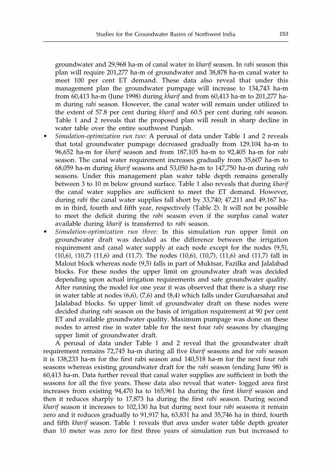
Studies for the Groundwater Basins of Northwest India 153
groundwater and 29,968 ha-m of canal water in kharif season. In rabi season thisplan will require 201,277 ha-m of groundwater and 38,878 ha-m canal water tomeet 100 per cent ET demand. These data also reveal that under thismanagement plan the groundwater pumpage will increase to 134,743 ha-mfrom 60,413 ha-m (June 1998) during kharif and from 60,413 ha-m to 201,277 ha-m during rabi season. However, the canal water will remain under utilized tothe extent of 57.8 per cent during kharif and 60.5 per cent during rabi season.Table 1 and 2 reveals that the proposed plan will result in sharp decline inwater table over the entire southwest Punjab.
• Simulation-optimization run two: A perusal of data under Table 1 and 2 revealsthat total groundwater pumpage decreased gradually from 129,104 ha-m to96,652 ha-m for kharif season and from 187,105 ha-m to 92,405 ha-m for rabiseason. The canal water requirement increases gradually from 35,607 ha-m to68,059 ha-m during kharif seasons and 53,050 ha-m to 147,750 ha-m during rabiseasons. Under this management plan water table depth remains generallybetween 3 to 10 m below ground surface. Table 1 also reveals that during kharifthe canal water supplies are sufficient to meet the ET demand. However,during rabi the canal water supplies fall short by 33,740; 47,211 and 49,167 ha-m in third, fourth and fifth year, respectively (Table 2). It will not be possibleto meet the deficit during the rabi season even if the surplus canal wateravailable during kharif is transferred to rabi season.
• Simulation-optimization run three: In this simulation run upper limit ongroundwater draft was decided as the difference between the irrigationrequirement and canal water supply at each node except for the nodes (9,5),(10,6), (10,7) (11,6) and (11.7). The nodes (10,6), (10,7), (11,6) and (11,7) fall inMalout block whereas node (9,5) falls in part of Muktsar, Fazilka and Jalalabadblocks. For these nodes the upper limit on groundwater draft was decideddepending upon actual irrigation requirements and safe groundwater quality.After running the model for one year it was observed that there is a sharp risein water table at nodes (6,6), (7,6) and (8,4) which falls under Guruharsahai andJalalabad blocks. So upper limit of groundwater draft on these nodes weredecided during rabi season on the basis of irrigation requirement at 90 per centET and available groundwater quality. Maximum pumpage was done on thesenodes to arrest rise in water table for the next four rabi seasons by changingupper limit of groundwater draft.A perusal of data under Table 1 and 2 reveal that the groundwater draft
requirement remains 72,745 ha-m during all five kharif seasons and for rabi seasonit is 138,233 ha-m for the first rabi season and 140,518 ha-m for the next four rabiseasons whereas existing groundwater draft for the rabi season (ending June 98) is60,413 ha-m. Data further reveal that canal water supplies are sufficient in both theseasons for all the five years. These data also reveal that water- logged area firstincreases from existing 94,470 ha to 165,961 ha during the first kharif season andthen it reduces sharply to 17,873 ha during the first rabi season. During secondkharif season it increases to 102,130 ha but during next four rabi seasons it remainzero and it reduces gradually to 91,917 ha, 63,831 ha and 35,746 ha in third, fourthand fifth kharif season. Table 1 reveals that area under water table depth greaterthan 10 meter was zero for first three years of simulation run but increased to
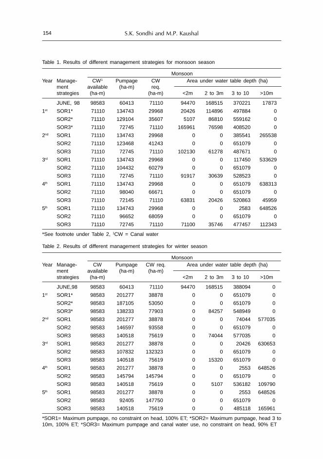
S.K. Sondhi and M.P. Kaushal154
Table 1. Results of different management strategies for monsoon season
MonsoonYear Manage- CW1 Pumpage CW Area under water table depth (ha)
ment available (ha-m) req.strategies (ha-m) (ha-m) <2m 2 to 3m 3 to 10 >10m
JUNE, 98 98583 60413 71110 94470 168515 370221 17873
1st SOR1* 71110 134743 29968 20426 114896 497884 0
SOR2* 71110 129104 35607 5107 86810 559162 0
SOR3* 71110 72745 71110 165961 76598 408520 0
2nd SOR1 71110 134743 29968 0 0 385541 265538
SOR2 71110 123468 41243 0 0 651079 0
SOR3 71110 72745 71110 102130 61278 487671 0
3rd SOR1 71110 134743 29968 0 0 117450 533629
SOR2 71110 104432 60279 0 0 651079 0
SOR3 71110 72745 71110 91917 30639 528523 0
4th SOR1 71110 134743 29968 0 0 651079 638313
SOR2 71110 98040 66671 0 0 651079 0
SOR3 71110 72145 71110 63831 20426 520863 45959
5th SOR1 71110 134743 29968 0 0 2583 648526
SOR2 71110 96652 68059 0 0 651079 0
SOR3 71110 72745 71110 71100 35746 477457 112343
*See footnote under Table 2, 1CW = Canal water
Table 2. Results of different management strategies for winter season
MonsoonYear Manage- CW Pumpage CW req. Area under water table depth (ha)
ment available (ha-m) (ha-m)strategies (ha-m) <2m 2 to 3m 3 to 10 >10m
JUNE,98 98583 60413 71110 94470 168515 388094 0
1st SOR1* 98583 201277 38878 0 0 651079 0
SOR2* 98583 187105 53050 0 0 651079 0
SOR3* 98583 138233 77903 0 84257 548949 0
2nd SOR1 98583 201277 38878 0 0 74044 577035
SOR2 98583 146597 93558 0 0 651079 0
SOR3 98583 140518 75619 0 74044 577035 0
3rd SOR1 98583 201277 38878 0 0 20426 630653
SOR2 98583 107832 132323 0 0 651079 0
SOR3 98583 140518 75619 0 15320 651079 0
4th SOR1 98583 201277 38878 0 0 2553 648526
SOR2 98583 145794 145794 0 0 651079 0
SOR3 98583 140518 75619 0 5107 536182 109790
5th SOR1 98583 201277 38878 0 0 2553 648526
SOR2 98583 92405 147750 0 0 651079 0
SOR3 98583 140518 75619 0 0 485118 165961
*SOR1= Maximum pumpage, no constraint on head, 100% ET; *SOR2= Maximum pumpage, head 3 to10m, 100% ET; *SOR3= Maximum pumpage and canal water use, no constraint on head, 90% ET

Studies for the Groundwater Basins of Northwest India 155
45,959 ha and 112,343 ha in fourth and fifth kharif season. During rabi season itincreases to 109,790 ha and 165,961 ha in fourth and fifth season (Table 2).
The simulation optimization run results in area under water table depth < 2 min Guruharsahai, parts of Jalalabad and Muktsar blocks where as declining watertable trend was observed in Fazilka, Khuian Sarwar and Abohar blocks. Theproblem of area having water table depth < 2 m can be solved by increasing thepumping limit to maximum possible discharge limit.The declining water table areacan be controlled by reducing the pumping in that area and meeting the remainingirrigation demand by transfer of canal water from rising water table area todeclining water table area. Another alternative could be to decrease the pumpingin declining water table area by shifting the cropping pattern so that irrigationrequirements are reduced as compared to existing one. This can be achieved bydecreasing the area under paddy in Fazilka, Khuian Sarwar and Abohar blocks.
Case Study of Sirhind Canal Tract
The Sirhind canal tract of Punjab comprises of four districts: Ludhiana, Patiala,Sangrur and parts of Ropar. Water table has been declining in most of the blocksin this tract for the last three decades. Out of the total irrigated area, seventy fivepercent is now irrigated by groundwater through tube wells, against 55% threedecades ago. Because of excessive extraction of groundwater the water table isdeclining at the rate of 17 cm to more than 1 m per year. This has resulted inlowering of existing centrifugal pump sets deeper into the pits to meet their suctionrequirement or have been replaced by costly submersible pump sets. In order todevelop various strategies for management of water resources in this tract amanagement model was developed and combined with simulation model usingresponse matrix approach.
Groundwater Simulation Model
The two-dimensional groundwater flow equation was used to simulategroundwater flow in non-homogeneous, anisotropic aquifer. The Galerkin’s finiteelement method with linear quadrilateral elements was used to discretize thegroundwater flow equation in space. The region was sub-divided into 49quadrilaterals having 73 nodes. Eigen-value solution of the resulting ordinarydifferential equation was obtained continuous in time (Kaushal and Khepar, 1988).The model was used to compute hydraulic head at nodal points and at the waterlevel observation points being monitored by the Central Groundwater Board, StateWater Resources Directorate and State Department of Agriculture (Fig. 3) Thevalue of transmissivity varied from 700-2500 m2/day and storage coefficient was0.2. The expected value of recharge for part of the Sirhind canal tract (Fig. 3) was74,692 ha-m, whereas the withdrawal for the year 1987-88 was 100,896 ha-m. Therewas a decline of water level at the rate of 0.18 to1.4 m/ year, the higher value ofdecline occurred in the central part of the tract.

S.K. Sondhi and M.P. Kaushal156
Management Model
A chance constrained linear programming model was developed (Kaushal &Khepar, 1992).
Objective function: The objective was to maximize annual net returns. Themaximum net return (Max Z) is given by the equation:
2 W K 2Max Z = ∑ ∑ ∑ NRswk Xswk - ∑ CSs SWs
S=1 w=1 k=1 S = 1
2 N N— ∑ ∑ CTsn TWsn - ∑ PCTWn (NSLn + DHn - hn) (8)
S=1 n=1 n = 1
where,S = growing season (S=1 for winter season and S=2 for monsoon season);W = level of water application, W=1,2,.. W; k = crop index, k=1,2...K; n = finiteelement, n=1, 2..N; NRswk = net returns; Rupees/ha, above all variable production cost, excludingthe cost of irrigation water, from crop k with level of irrigation water W inseason S;Z =total net returns, in Rupees over variable costs;Xswk =area in ha allocated to crop k, grown with level of irrigation water W inseason S;CSsn = cost in Rupees for applying 1 ha-m of canal water in season S;SWs = canal water in ha-m allocated at head of the field in season S;CTsn = cost in Rupees for applying 1 ha-m of groundwater at node n in season S;TWsn= groundwater in ha-m allocated from element n in season S;NSLn = natural surface elevation (RL) in metres at node n;
Figure 3. Study area showing land surface contours (m) and water table observation points
BLOCK BOUNDARYDISTRICT BOUNDARY4AI.OBS PT.CGWB1AI.OBS PT. WRD61-OBS PT. DPT. AGRICULTURECANALRIVER
-235- LAND SURFACE CONTOUR
GHAGGAR BRANCH
LehraGaga
RIVER GHAGGARBHAKRA MAIN LINE CANAL
0 2965 14825 m
SIRH
IND
CANA
LIII
RD F
EEDE
R
DhawanGarh
Nabha Samana
Sunam
TOHANA
PA IIA LA146
255
247
345 263 24
1
210 4A2
LAI
239
237
2095611.47
235
233
231
229
227
237
59
57
238
105
60
223
221
225
61 104
102
IAI
III

Studies for the Groundwater Basins of Northwest India 157
DHn = dynamic head in meters at node n;hn = hydraulic head elevation (RL) in metres at node n andPCTWn = penalty cost weighting factor, Rupees/m of head, because of water levellowering at node n.
Constraints
(i) In applying the model, following constraints have been taken into consideration.Water allocation: Irrigation water requirements of crops must be met fromcanal and groundwater supply in season at a probability of b
K W NP { ∑ ∑ NIRswk Xswk ≤ SWs + ∑θct TWsn} ≥ β for all s (9)
k=1 w=1 n=1
where,NIRswk = irrigation water required in ha-m for crop k with irrigation level Win season S;q = tubewell water conveyance efficiency;P = probability operator;b = probability level, 0 < bs £ 1The deterministic equivalent to the probabilistic constraint when formulated interms of chance constrained is:K N∑ S-1swk (βs) Xswk ≤ SWs + ∑θct TWsn for all s (10)k=1 n=1-1swk (βs) is inversse distribution function of NIRswk for βs level of assurance.
(ii) Land area: The total area under various crops in each season cannot exceedthe total available area for irrigation
K W
∑ ∑ ALFAs Xswk ≤ Tas for all s (11)
k=1 w=1
whereALFAs = land area occupying coefficient for crop activity (ALFAs = 1, if the
crop is grown in the season S, otherwise it is zero), andTas = crop land in ha available in season S
(iii) Canal water: Canal water allocated in season S cannot exceed canal wateravailable in season S after allowing for all losses.
SWs ≤ ASWs For all S (12)where,ASWs = canal water in ha-m available in season S after allowing for all losses.
(iv) Tubewell water: Tubewell water allocated from element n cannot exceedtubewell water available in season
TWsn ≤ ATWsn for all s,n (13)
where,ATWsn = tubewell water in ha-m available in season S.

S.K. Sondhi and M.P. Kaushal158
(v) Minimum area:W∑ Xswk ≥ MIARsk for all s and k = 3,10,11,13 (14)w=1
where,MIARsk = minimum area in ha required for crop k grown in season S.
(vi) Maximum allowable area:
W∑ Xswk ≤ MAALsk For s = 1; k = 5 (15)w=1
where,MAALsk = maximum area in ha allowable to crop k grown in season S.
(vii) Hydraulic head : The hydraulic head in an element cannot exceed thehydraulic head elevation simulated by the groundwater model at node nhn ≤ hsmm for all n (16)
where,hsmn = hydraulic head elevation (EL) in meters simulated by groundwatermodel at node n.
(viii) Non-negativity :
Xswk ≥ 0; Sws ≥ 0; TWsn ≥ 0; hn ≥ 0 (17)
Methodology
A tract in Sirhind Canal (Fig. 3) bounded by the Bhakra Main Line Canal,Ghaggar Branch, Sirhind Canal Third Feeder and River Ghaggar was used forapplication of the models (Figure 3). The tract lies between latitude 29° 38' 27" Nto 30° 24' 7"N and longitude 75° 51' 15" E to 76° 15’E. The climatic conditions in thetract are, severely cold winters particularly in the month of December and January,and intense hot summers in April, May and June. Mean monthly air temperatureduring winter is 5° C whereas mean monthly air temperature in the summerreaches 40° C.
The groundwater simulation model was calibrated and validated for predictionof groundwater table by using observations for the period 1975 to 1987. Thesimulation model was used to determine the effect of unit responses in terms ofgroundwater withdrawal on hydraulic head. An assemblage of unit responses wasincluded in the management model. Other inputs to the management model werenet irrigation water requirement of crops at 5% and 25% risk levels (expectedvalues of ET was taken as average of 30 years, rainfall was considered probabilistic,and, a two parameter gamma distribution was fitted to the monthly rainfall data),water resources availability, cost of irrigation water and net returns excluding thecost of irrigation water. Net irrigation requirements of crops were computed bydiminishing effective rainfall (using USDA, SCS method) at 5% and 25% risk level,from the expected value of ET. Water application was considered at levels 1, 2, 3

Studies for the Groundwater Basins of Northwest India 159
and 4, which corresponds to water production functions at 25, 50, 70 and 100% ofthe net irrigation water requirement. Crop water production functions weredeveloped based on experimental observations (Rajput, 1985). Four type of functionswere used (Eqs. 18 to 21) namely Cobb-Douglas, quadratic, square root andModified Mitscherlich-Spillman functions for wheat (Triticum aestivum), barley(Hordeum vulgare), raya (Brassica juncea), gram (Cicer ratinum), potato (Solanumtubersom), berseem fodder (Trifolium alexandrinum), rice (oryza sativa), cotton(Gossypium arborium), maize (Zea mays), sugarcane (Saccharum offinarum), groundnut(Arachis hypoge), green gram (Phaseolus radiata) and sorghum fodder (Sorghumvulgare)
Cobb-Douglas function
Y = a Wb (18)
Quadratic function:
Y = a + bW + CW2 (19)
Sqare-root function
Y = a + bW + cW0.5 (20)
Modified Mitscherlich-Spillman functions
Y = a (1-e-b(w+c)) (21)
where,Y = crop yield, q/ha; (1quintal=100 kg)W = depth of water applied, cm anda, b, c = constants
The crop yield is influenced by crop variety and soil fertility. However, thesefactors were fixed and only water applied was considered a variable. The soilswere sandy loam. The available nutrients such as organic matter, P
2O
5 and K
2O
varied from 0.162 – 0.308%, 1.8 – 13.2 and 51 – 113 kg/ha,respectively.The model outputs are in terms of cropping pattern, canal water and
groundwater allocation and hydraulic heads at nodes for maximized net returns.The depth of pumping cost of water, rain, price of crop and availability of land andwater influence maximized net returns. In this study the hydraulic heads at nodalpoints were made a constraint in the management model. The cost of canal waterand groundwater was Rs 240 and Rs 927 per ha-m of water, respectively. Theannual rainfall was 38 cm at 75% probability level. Prices of crops prevailing inPunjab during the year 1988 were used. Total land resources of the study area were115,803 ha. The annual canal water and groundwater resources available were39,170 ha-m and 100,896 ha-m, respectively.
Water Production Functions
The best-fit water production functions based on statistical analysis are givenin Table 3. The quadratic functions were selected for wheat, barley, raya, gram,rice, sugarcane, moong and sorghum fodder; square root functions for cotton,maize and berseem fodder; Modified Mitscherlich-Spillman functions for potatoand groundnut crops.

S.K. Sondhi and M.P. Kaushal160
Table 3. Crop water production functions
Sl.No. Crop Coefficients R2 F-value
a b c
Quadratic
1. Wheat 16.31263 1.034402 -0.012068 0.985 67.12*(5.65*) (-2.6) NS
2. Barley 9.586905 0.654469 -0.009018 0.972 17.58NS(2.55) NS (-1.09) NS
3. Raya 9.0495 0.212845 0.002534 0.957 11.11NS(1.83) NS (-.67)NS
4. Gram 8.65822 0.2777529 -0.003947 0.914 5.32NS(1.41) NS (-0.62) NS
5. Rice -1.632408 0.357109 -0.000431 0.998 294.40*(2.78) NS (-1.33)NS
6. Sugarcane - 37.435425 9.717468 -0.024837 0.996 153.45*(7.27*) (-5.18)NS
7. Green gram - 2.08542 0.914279 -0.020513 0.890 4.07NS(2.02) NS (-1.74) NS
8. Sorghum fodder 161.66644 7.125275 -0.055064 0.947 9.08NS(2.16) NS (-1.81)NS
Square root
9. Cotton - 29.346767 -0.730293 12.418518 0.974 18.89*(-1.32)NS (1.79)NS
10. Maize - 32.315575 -1.256317 18.086426 0.945 8.67NS(-48)NS (0.71)NS
11. Berseem fodder 20.887573 -10.78100 182.26563 0.979 23.92*(-3.0)NS (3.47*)
Modified Mitscherlich-Spillman functions
12. Groundnut 21.2 0.084569 4.6319 0.862 12.54NS(3.54*)
13. Potato 205.0 (0.082384) -28.3002 0.630 3.41NS(1.84) NS
Note: ** The values in parentheses are t-values for the coefficients significant at 1% level of significance * Significant at 5% level of significance NS: Not significant at 5% level of significance
Optimization of Net Benefits
The results of management model combined with simulation model usingresponse matrix approach were obtained at risk levels of 5% and 25% (95% and75% probability of rainfall). The cropping pattern is given in Table 4. As the risklevel increased from 5% to 25% the area under wheat and cotton at waterapplication level 3 increased from 59,853 ha to 68,778 ha and 100,749 ha, respectively.Maize shifts to water application level 4. Rice and sugarcane that have a higherwater requirement are deleted from cropping pattern. Canal water and groundwaterwere fully utilized. The hydraulic head remained at the levels predicted by thegroundwater simulation model. As the risk level increased from 5 to 25% theannual net returns increased. The reason for this is, that with an increase in risk

Studies for the Groundwater Basins of Northwest India 161
level, the irrigation water requirements of crops decreased. The model adjusts theallocation of land and water resources in such a way that more area is allocated tocrops under higher levels of water application, thereby increasing annual netreturns. The study did not consider labour as a constraint. However the resultsmay be influenced if high value, labour intensive crops are included in cropplanning.
Table 4. Land and water allocation at 5 and 25% risk level
Crop Risk level
5% 25%
Water Irrigation Area Water Irrigation Areaapplication (cm) (ha) application (cm) (ha)
index index
Winter wheat (2) 29.1 46844 (2) 28.3 37919
Wheat (3) 43.6 59853 (3) 42.4 68778
Mustard (3) 33.3 2316 (3) 32.0 2316
Berseem fodder (2) 50.9 6790 (3) 49.7 6790
Monsoon cotton (3) 48.6 64175 (3) 59.1 100749
Cotton (3) 72.8 36574 — — —
Maize (3) 35.8 2316 (4) 35.7 2316
Green gram (2) 25.6 1158 (2) 18.3 1158
Sorghum fodder (3) 37.5 11580 (2) 17.8 4876
Sorghum fodder — — — (3) 26.8 6704
Annual net returns (M INR) 1271.5 1304.5
Case Study of Southwest Haryana
The main hindrance for agricultural development in southwest Haryana is thescarcity of water resources to irrigate farmer’s fields. In order to find solutions foroptimum water management for this region a regional water management analysishas been carried out using an integrated model for Sirsa Irrigation Circle. (Aggarwaland Roest, 1996)
Description of Sirsa Irrigation Circle
Sirsa Irrigation Circle, with an area of about 0.42 million hectare (ha), representsarid climatic conditions with annual average rainfall varying from 300 to 550 mm,less than 25 rainy days and an annual potential evapo-transpiration from 1500 to1650 mm. The topography of the area consists of gently sloping terrain with someisolated steep contours in the vicinity of the Ghaggar River. The general directionof the landscape slope is from east to west and towards the Ghaggar river. Thedifferent geomorphological units found in Sirsa Irrigation Circle are the recentalluvial plains and aeolian plains with sand and sand dunes. The soil texture variesfrom loamy sand to sandy loam with some sandy soils occurring in patches.
Canal water supply to Sirsa Irrigation Circle is provided through three canals:Bhakhra Main Line in the north serving about 34,4000 ha; Sukhchain Distributary
S.K. Sondhi and M.P. Kaushal162
in the central part serving about 29,500 ha and Fatehbad Distributary in the southserving 18,200 ha. The Ghaggar river is only carrying water during some monthsin the monsoon season and its water is partly used for irrigation during thesemonths through Ottu feeder. A part of the feeder, infiltrates in the riverbed,resulting in recharging of the groundwater aquifer. Total annual canal watersupply was about 5 * 109m3. The canal water supply triggered rising water tablesin the northwest and southeast where groundwater is poor. Due to deficiencies inthe canal water supply, over-exploitation of groundwater in the belt along theGhaggar river, where groundwater quality is good, caused a decline in the watertables. The maximum annual rise in water table in the northwest and southeastduring the period between 1976 and 1991 was over 1 m and the maximum declinein the central part of the area was 0.4 m annually. The scenarios presented here arebased on an extensive set of data and gives a more detailed view of the problemfor Sirsa district compared to the trends presented on state level.
The groundwater quality on both sides of the Ghaggar river is generally good,resulting in the installation of numerous tube wells in its vicinity during the pastseveral years. Groundwater quality in the western side in Dabwali block is quitepoor from varying 7 to 10 dS m-1, restricting its use for irrigation. During the lastfive years, however, relatively good quality water developed along canals, overlyingthe saline groundwater, prompting farmers to go for shallow tubewells. Generalmovement of groundwater is from Ghaggar river towards the northwest andsoutheast. During 1992 water table depths ranged from 1.5 – 25 m in the area withthe shallowest groundwater table are found in the Phaggu-Rori area in the east andthe deepest in Sikanderpur in the southeast. Serious water logging and salinityproblems have emerged in the Phaggu, Desu and Rohan villages of Rori area,leading to the loss of large tracts of agricultural lands.
Major crops in Sirsa Irrigation Circle are wheat, cotton and gram. 17% ofpotential cultivable land is kept fallow, while about 45% of the remaining area wasirrigated in winter and 57% during summer.
Model Calibration and Validation
Study area was subdivided into 46 calculation units for simulation study. Thecanal water command system was followed in classifying these units. Within theboundaries of calculation units, homogeneity was assumed with respect to soils,cropping pattern, climatic conditions, groundwater salinity and depth ofgroundwater table depth.
Model calibration on observed historical groundwater levels was performedfor the observation period from 1977 to 1988. Calibration was achieved by adjustingnumber of spatially distributed input parameters such as, storage coefficient,transmissivity and soil physical parameters. After calibration of input parametersfor the period from 1977 to 1981, the model was validated for the period from 1982to 1990. The validation results were satisfactory for the complete study area withpredictive value of 75% and higher. In about 52% of study area the predictedvalues were matching even above 90%.

Studies for the Groundwater Basins of Northwest India 163
Description of Integrated Model
Integrated model consists of SIWARE for canal and on –farm water managementand SGMP for regional groundwater flow (Smit et al., 1996 and Boonstra et al.,1996). The integrated model comprises of a number of sub-models DESIGN,FRAME, WDUTY and REUSE required for pre-processing of data and computationof water distribution, canal seepage and spatially distributed crop waterrequirements.
Water Management Analysis
The analysis of water management in Sirsa irrigation circle, using the integratedmodel, provides observations on: water supply and crop coater requirement andrecharge of groundwater.
i) Water supply and crop water requirement: The water requirements of irrigatedcrops were computed by the model that are to be met by canal water supply,rainwater and groundwater exploitation. The water supply from canal and rainfallexceeded the crop demands with about 15% during the first four months fromJanuary till April and with about 90% in December. The water supply was deficientby about 30% during the months of May and June and 40-50% during the monthsof September till November. During the months of July and August the supplycovered the demands almost completely. During the period from 1977 to 1990 theaverage annual shortage of water supply was 210 mm for the water deficiencyperiods. The average annual excess in water supply was 50 mm with a minimumof 25 and a maximum of 125 mm. The irregular and erratic rainfall causedsignificant deviation from these average values both in time and space.
ii) Recharge of groundwater: Because of the absence of drainage systems, wateravailable through rainfall, groundwater pumpage and canal water in excess of thewater holding capacity of soil, percolates to the aquifer system. Recharge causesgroundwater table to rise. For a number of reasons the total quantity of waterreceived by Sirsa Irrigation Circle was not fully utilized, and resulted in water tablerise. The following recharge components were recognized:• Excess rainfall on non- agricultural areas• Seepage losses from canals• On-farm water losses• Aquifer recharge by Ghaggar river during the monsoon period.
The seepage losses from canals were about 25% of the total losses and 10% ofthe canal water supply. On farm water losses were caused by seepage losses fromthe field irrigation channels, percolation and leaching losses due to rainfall events,especially if they occurred just after field irrigation of crops. Percolation lossesduring field irrigation were generally not caused by excessive canal water supply,but due to the uneven field water distribution. The border and furrow irrigationmethods applied by farmers caused relatively more infiltration at the heads of thefields compared to the tail ends. Also imperfect land leveling and non-ideal slopingfields promoted inhomogeneous water distribution within agricultural fields. Theon-farm water losses accounted for about 60% of the total aquifer recharge and25%of the canal water supply.

S.K. Sondhi and M.P. Kaushal164
Conveyance losses from the canals showed only moderate fluctuations duringthe period between 1997 and 1990, while the other losses varied from about 175mmha-1 to as much 400 mm ha-1. Defining the overall project efficiency as the ratio ofcrop evapo-transpiration and total water-supply (including rainfall and groundwateruse), the system can be classified as highly efficient with values varying between68 and 79% for the different years. However, large spatial differences in aquiferrecharge occurred in the area, during this period.
The analysis of water management in Sirsa Irrigation Circle revealed thatirrigation performance was quite good resulting in a high overall project efficiencyranging from 68% to 79%. The average annual canal water supply was sufficient tomeet the water requirements of irrigated crops during winter and early spring, forthe winter irrigation intensity of 45%. During the summer and monsoon season thehigh water requirements for irrigated crops with irrigation intensity of 57% wasmet through canal irrigation and rainfall for 50 to 60%.
The combined effect of irregular rainfall, canal seepage; water-holding capacityof soils, and irrigation methods used by farmers resulted in percolation losses tothe aquifer with a high spatial variability. In about 20% of the area, total annualpercolation losses varied from 450 to 625 mm ha-1, in 60% of the area from 150 to450 mm ha-1 and in the remaining 20% from 75 to 150 mm ha-1. The annual canalseepage varied from 85 to 125 mm. The percolation losses together with canalseepage and conveyance losses from the Ghaggar river, caused in major parts ofSirsa Irrigation Circle a groundwater table rise during the period 1977-1990 from0 to 16 m. In the belt along the Ghaggar river, groundwater tables declined due tosignificant groundwater abstraction rates. Here the decline varied from 2 to 6 m.The effective porosity in the aquifer system varies from 8-16%, so a change of 1min water table depth changes the groundwater reservoir with 80 to 160mm.
Alternative Water Management Strategies
Future regional water management strategies for Sirsa Irrigation Circle shouldsolve the problem of rising water tables in the northern and southern part of thearea and problem of declining water tables in the central part of the study area.Although, a complete solution cannot be achieved without a drainage outlet toremove the salts imported with the irrigation water, the question remains whetheran adapted regional water management could delay the rise of water tables in theendangered zones. This means that alternatives have to be found to reduce theaquifer recharge in the rising water-table areas, increased groundwater use in theseareas and/or increased recharge in the areas with falling water tables of reducedgroundwater use in these areas.
Increased groundwater use in areas with rising water tables and poorgroundwater quality is an issue, which should be solved at the level of on-farmwater management. Implementation of such strategies has to be pursued throughextension services to farmers in order to convince the profitability to extend theirirrigated area using supplemental irrigation and manage the deficient canal watersupply.
Out of the four components of aquifer recharge, the regional water managerdoes not control two. These are the recharge due to rainfall in the non-agriculturalareas and the recharge from the Ghaggar river during monsoon. The later takes

Studies for the Groundwater Basins of Northwest India 165
place in the zone of declining water table and is rather beneficial. Two rechargecomponents are under control of the regional water manager. These are the canalseepage losses and the on-farm water management losses. The canal seepage losseswere estimated at about 10% of the canal water supply. Further reduction of theselosses of this highly efficient system will be very difficult to achieve.
Two water management strategies addressing the reduction of on-farm waterlosses to the aquifer were evaluated and discussed as follows. Both strategies wereapplied for the period between 1971 and 1990, to enable comparison with thehistorical water table development.
Water Pricing
The analysis of on-farm water management resulted in recommendations toincrease the irrigated area using the same amount of canal water. Reducedirrigation water application, as proposed, can be implemented by changing themethod of recovering the cost of irrigation water from farmers. Presently, farmersare charged on the basis of irrigated area. Although water charges are quite low,farmers are not encouraged by this system to irrigate more land with the sameamount of water.
In the water pricing alternative strategy, it was assumed that payment forwater would be based on the amounts of water delivered to farmers, givingfarmers freedom to optimize their on-farm water management operations withoutadditional charges. Given the present Warabandi water-supply system, which isbased on equity, such a change in water pricing methodology does not involveexpensive and laborious monitoring of volumes delivered. Simple changes in thebasis of pricing from irrigated area from 50% to about 85% was assumed in thesimulations by converting the rainfed crops to irrigated crops.
As a result of this strategy, the crop evapo-transpiration increased at theexpense of water losses to the aquifer. The annual rise in water table in the utmostnorthwestern and southeastern part of Sirsa district reduced by about 15%. Byadopting this strategy water logging problems cannot be avoided, but can bepostponed by 5 to 10 years. At the same time total crop production in the areaappeared to increase as well. However, through this strategy, declining water tablein the central part of the area was not arrested.
Water Supply According to Demand
Adjusting the temporal and spatial canal water supply to the actual crop waterrequirements of the irrigated crops can obtain additional water use efficiencyimprovements. Presently, canal supply exceeds requirement by about 55 mmduring the winter period and the late summer shortage in supply is about 210 mm.The present canal water distribution is based on cultivable area rather than onwater requirements of the irrigated cropping pattern. This could be improved bydiscarding the Warabandi system and by distributing canal water based on thespatially distributed crop water requirements. During the monsoon period, irrigationwater requirements depend to a large extent on rainfall. Solutions for technical andmanagerial provisions to adjust canal water supply to the erratic and spatiallydistributed rainfall conditions were considered beyond the scope of study. Although

S.K. Sondhi and M.P. Kaushal166
application of regional models as predictive tools, can play prominent role infuture water management accounting for rainfall, at this stage, long-term averagerainfall has been assumed as input for matching the water distribution with thespatial and temporal distributed water requirements.
The effects of this regional water management strategy were expressed in thenumber of years elapsed until water logging occurred. In the reference situationwith unchanged water management, in about 10% of the Sirsa Circle, waterlogging problems will occur within a time period of 15 to 45 years. With waterdistribution matching the temporally and spatially distributed water requirements,these percentages are considerably reduced. In about 5% of the area water loggingis expected within 5 years, in about 15% of the area within 5 to 15 years and inabout 25% water logging problems will occur within a time period of 15 to 45years. An additional benefit from this alternative is that in the central part of Sirsadistrict with declining water table, a status quo or a reversed situation wasachieved.
Evaluation of Alternatives
Compared to the present canal water management system in Sirsa IrrigationCircle, both, alternative strategies have the advantage that rising water tables weredelayed in the saline groundwater areas in the north and south of Sirsa district.Water distribution according to demand was slightly more effective in these areas.In the central part of Sirsa district water distribution according to demand led toslightly rising water tables. This could easily be corrected by reducing canal watersupply to these areas or by compensating the increased recharge with moregroundwater use.
The strategy of changing water pricing has the obvious advantage that noinvestments are required and operation of the canal system can be maintained atthe present mode. The strategy with distribution according to demand requires adifferentiated allocation and distribution of canal water and the present system ofdistribution based on equity has to be abandoned. For the strategy with distributionaccording to demand a number of practical constraints have to be solved: waterscheduling and control requires more labour and additional investments to adaptwater control structures. Such a system will be more susceptible to sabotage andbribery by influential farmers trying to receive more canal water. Also social andpolitical constraints must be solved before implementing such a strategy. Farmersin the advantageous situation with access to good quality groundwater will receivemore canal water than their colleagues in the poor quality groundwater zones.
Policy Implications
The lessons drawn from three case studies –Southwest Punjab and SrihandCanal Tract in Punjab and Sirsa Irrigation Canal in southwest Haryana provideevidence for policy issues pertaining to management of groundwater. The policyimplications that can be drawn are:

Studies for the Groundwater Basins of Northwest India 167
Groundwater Legislation
There is need to enact proper groundwater legislation to prevent indiscriminateexploitation of groundwater resource. In addition, inheritance of property law alsoneeds to be modified to prevent progressive fragmentation of land holdings. Thetask of water distribution becomes very simple and easy for a big size holding froman outlet in comparison to different sizes of holdings scattered all over thecommand area.
State Water Authority
India’s National Water Policy (Ministry of Water Resources, 2002) clearlyrecognizes that exploitation of groundwater resources should be regulated so thatit does not exceed recharging possibilities, and also ensures social equity. Thedetrimental environmental consequences of over-exploitation of groundwater needto be effectively prevented by the central and state governments. Water being thestate subject, the State Water Authority should be set up with an aim to regulateand control groundwater development and management on sustainable basis.
Agricultural Power Supply and Pricing Structure
The use of flat rate for electricity, combined with unreliable electricity supplyprovides no incentives for efficient use of groundwater. The subsidized electricitytariff also results in heavy financial losses to State Electricity Boards. Thus there isan urgent need to revamp agricultural power supply and tariff structure. Specificpolicy issues aiming at sustainable use of groundwater will need supportinginitiatives which ensure fair prices for alternate crops to growers through statemediated system.
Restructuring Subsidies
There is a need to restructure subsidies to encourage farmers to adopt efficientirrigation methods and improve water management with a view to improvegroundwater use efficiency.
Stakeholder Participation
Participation of farmers, NGOs and scientists in defining and pursuing thestrategies for sustainable resource use should be encouraged.
References
Aggarwal, M.C. and Roest, C.J.W. 1996. Towards improved water management in Haryana state. Finalreport of the Indo-Dutch operational research project on hydrological studies, CCS HAU, Hisar,Haryana and International Institute of Land Reclamation and Improvement and DLO WinandStaring Center for Integrated Land, Soil and Water Research, Wageningin, The Netherlands, 55-65.
Aggarwal, R., Sondhi S.K., Kaushal, M.P. and Jain, A.K. 2004. Optimal groundwater management inSouth-west Punjab, Journal of Research, Punjab Agricultural University, 41(1): 120-130.
Ahlfeld, D.P., and Manouchehr, H. 1994. Application of optimal hydraulic control to groundwatersystem. J. Water Resources Planning and Management, 120: 350-365.

S.K. Sondhi and M.P. Kaushal168
Boonstra, J., Singh, J. and Kumar, R. 1996. Groundwater model study Sirsa district, Haryana. Indo-Dutch operational research project on hydrological studies, Wageningin, The Netherlands.International Institute of Land Reclamation and Improvement. Technical report.
Brar, J.S. and Singh, B. 1993 Underground irrigation water quality in South Western district of Punjab.Journal of Research, Punjab Agricultural University, 30: 15-23.
Gorelick, S.M. 1983. A review of distributed parameter groundwater management modeling methods.Water Resources Research, 19: 305-19.
Kaushal, M.P. and Khepar, S.D. 1988. Groundwater scenario in 2000 AD in a canal command tract inPunjab. Proc. NSC-88, System’s Society of India, held at Coimbatore, Dec. 21-23: 373-377.
Kaushal, M.P. and Khepar, S.D. 1992. Optimizing net benefits from conjunctive use of water. InternationalCommission on Irrigation and Drainage Bulletin 41(1): 27-41.
Ministry of Water Resources 2002. National Water Policy. Government of India, Ministry of WaterResources, New Delhi. Pp. 9
Rajput, R.K. 1985. Research on water management. Progress Report 1979-81, 1981-1983 and 1983-84. Co-ordinated Project for Research on Water Manangement. ICAR, New Delhi.
Rhoades, J.D. 1974. Drainage for salinity control. pp. 433-62. In: J. Van Schilfgaarde. (ed.) Drainage forAgriculture. Am. Soc. Agron., Monograph no. 17.
Smit, A.A.M.F.R., Jhorar, R.K, Lokers, R. and Kortleve, W.J. 1996. Technical and functional documentationof the expert user interface for the linked SIWARE and SGMP models. Indo-Dutch operationalresearch project on hydrological studies, Wageningin, The Netherlands. DLO Winand StaringCentre, Technical report.
Smith, M. 1992. Cropwat: A computer program for irrigation planning and management. FAO Irrigationand Drainage Paper 46. Food and Agriculture Organization of United Nations, Rome.
Yeh, W.W.G. 1982. System analysis in groundwater planning and management. J. Water ResourcesPlanning and Management, ASCE, 118: 224-37.
Application of Hydraulic and EconomicOptimization for Planning Conjunctive Use of
Surface and Saline Ground Water: A Case Study
N.K. TyagiCentral Soil Salinity Research Institute, Karnal, India
Abstract
Conjunctive use of water from different sources is considered to be a valuable tool toovercome the constraint of the surface and groundwater systems, if operated independently.The conjunctive use planning requires establishment of firm water supplies and theirdistribution, effect of water development and use on groundwater behaviour, allocation ofwater to different users based on economic returns and tolerance to salinity,and effect ofsaline water use on surface and groundwater salinities. Decisions regarding the developmentand allocation of water are complicated processes and are best attempted through modeling.This paper deals with formulation and application of groundwater hydraulic optimizationand allocation models for planning the development and use of surface and groundwaterin Lower Ghaggar Basin of Haryana,India.
The problem of conjunctive water development and utilization planning has been dealtas a two-stage process. The first stage, deals with determination of optimal groundwaterdevelopment, while the second stage, deals with water allocation to crops in a conjunctiveuse milieu. For hydraulic optimization, a steady state flow optimization model has beenformulated to develop optimal groundwater pumping strategies. The model predicts theoptimal pumping volumes and the resulting groundwater potentiometric surfaces. Inassociation with a groundwater simulation model, it also makes possible to forecast the timeframe in which groundwater table in different sub areas in a region, would attain steadystate condition. The special features of the model are the inclusion of functions for stream-aquifer interaction and direct evaporation from the ground watertable. For water allocationand economic optimization, a non-linear conjunctive water use-planning model is formulated.The model maximizes net benefits from water use of varying salinities through allocationsto different crops and determines the optimal groundwater pumping for irrigation anddrainage water disposal.
Results of the application of the hydraulic optimization model show that there isconsiderable scope for augmenting the groundwater supply in areas adjoining the RiverGhaggar by increasing stream-aquifer interaction. The present stream aquifer interactionin river cells is of the order of 16 m3s-1, which can be increased to 26 m3s-1 with optimalpumping. The optimal potentiometric surfaces fall in the range of 184 to 214 m above MSLgiving a water table depth of 4 to 22 m, thus ensuring against waterlogging and salinitydevelopment.

N.K. Tyagi170
A non-linear conjunctive water use optimization model decides the water allocation todifferent crops and mapping of the resultant groundwater quality scenarios. A GAMSversion of the model is prepared for analysis with GAMS/ MINOS software. The allocationessentially centres on crop-water-salinity production functions, which are non-linear innature. The required production functions have been developed with basic data on crop-water-production and applied water-salinity-yield functions. The two functions for whichthe experimental data were available from different sources are synthesized into a singlewater-quality-quantity production function. The required costs and benefits estimates fordifferent activities were developed using standard techniques of estimating and costing. Theestimates of groundwater in different quality zones are based on water quality informationfrom shallow tubewells, which was subjected to analysis by statistical software calledGEOEAS.
It appears from the results of economic optimization that cash crops such as cotton andmustard, which are otherwise, also salt tolerant, will find favour with increased salinewater use, if risk associated with pest and disease is minimized. Increase in cost of wateris not likely to make any difference in water allocation due to large differences betweenreturn from water use and the present cost of irrigation water. Conjunctive use of salinegroundwater with canal water on sustained basis will require disposal of some part of salinewater through evaporation ponds and regional drains. Volume of groundwater to bedisposed is governed by quantity and quality of canal water supply and the quality ofgroundwater. This minimum quantity of disposable water in the lower Ghaggar Basin is14 percent of the annual recharge.
Introduction
The survival of mankind depends upon its ability to produce enough food andprovide enough water for public health and industrial purposes. As the competitionfor water grows, the need to use the available resource efficiently without impairingits quality increases. This can be achieved by proper planning and management ofwater resources. For surface water, the stream flows with high temporal andspatial variability, are to be converted into a set of comparatively regular flows. Forgroundwater, the pumping rates are to be adjusted to suit the aquifer propertiesand the sustainable recharge. Optimal development of water resource is generallythe outcome of the conjunctive use of water from various sources (Hall, 1986).Conjunctive use of water resources can be defined as the management of multiplewater resources in a coordinated operation such that the water yield of the systemover a period of time exceeds the sum of water yields of the individual componentsof the system resulting from uncoordinated operation. Normally conjunctive use isplanned and practiced with the objectives of mitigating the effect of shortages incanal water supplies, increasing the dependability of the existing water supplies,alleviating the problem of high water table and salinity, facilitating the use of highsalinity groundwater and mitigating the damages due to drought (Abrol et al.,1988).
In the canal irrigated area, introduction of huge quantities of water fromoutside areas, results in disturbance of existing hydrologic equilibrium of thegroundwater basin. Increased groundwater accessions induce positive net recharge,forcing a rise in water table very close to the surface and creating significant

Planning Conjunctive Use of Surface and Saline Ground Water 171
waterlogging and salinity. In areas, where groundwater quality is good and aquiferformations favorable, increased recharge adds to the water resources of the area ina dependable manner. This is because such water can be developed and usedaccording to crop requirements. However, in many places, irrigated areas areunderlain by aquifers of poor quality and in normal course; there is very littlegroundwater development in such areas. In the absence of commensurate groundwater withdrawal, rise in water table beyond permissible limit is inevitable. Sucha situation exists in a major part of the southwestern part of Haryana, Punjab andnorth and eastern parts of Rajasthan. States of Gujarat, Maharashtra, Karnatakaand Tamil Nadu also face similar situations.
Under the given surface water supply conditions, the development and use ofwater resources in the saline ground water basin involves four distinct processes.The first process, is concerned with planning the development of resources.Mathematical models, that can simulate and predict the system response to themanagement and hydrologic simulation, are often used for planning thedevelopment. Outputs from simulation model do not answer the whole range ofquestions and a different set of the models called optimization models are required(Lefkoff and Gorelick, 1990). The second process, is concerned with simulating theeffect of saline water use on crop production. This is, essentially an agronomiccomponent and has to do with establishing crop-water-salinity production function.The response of crops and stages of growth to water and salinity stress differs. Theeffect is also amenable to change with water application technologies and culturalpractices (Zeng et al., 2001). The third process, deals with hydrologic system insaturated and unsaturated zones. Development and utilization of water resourcesdisturbs the hydrologic equilibrium. The system remains in transient stage till thenew equilibrium is reached. The direction of change may be both positive (beneficialto the environment) and negative (harmful to the environment), but extremes ineither direction are unfavorable to the environment. In physical terms, the processincludes changes in the hydro-salinity regimes of the ground water basin. Thefourth and final process is economic in nature and deals with profitability ofinvestments.
A number of conjunctive use planning models have been developed to determinepumping rates for a sustainable potentiometric surface (Tyagi et al., 1995), allocationof water to areas under different crops and optimal hydro-salinity regimes in abasin (Tyagi, 1987). The economic aspects of water allocations have receivedgreater attention and both linear (Khepar and Chaturvedi, 1982; Tyagi et al., 1993)and dynamic programming models (Knapp and Wichelns, 1990) have been used insuch studies. Groundwater simulations have also received greater attention, andanalytical as well as numerical approaches have found use (Helweg and Labadie,1976; Lefkoff and Gorelick, 1990), but the models that develop a quantitativeunderstanding of economic, agronomic and hydrologic processes that occur in asaline irrigated system have been rather limited.
This paper deals with formulation and application of ground water hydraulicand economic optimization models for planning the development and use ofsurface and ground waters in Lower Ghaggar Basin (LGB) of Haryana,India. In thispaper the problem of conjunctive water development and use planning has beenaddressed as a three-stage process. The first stage deals with the determination of
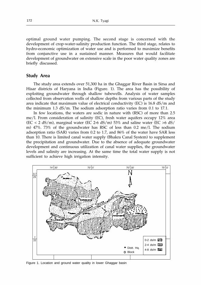
N.K. Tyagi172
optimal ground water pumping. The second stage is concerned with thedevelopment of crop-water-salinity production function. The third stage, relates tohydro-economic optimization of water use and is performed to maximize benefitsfrom conjunctive use in a sustained manner. Measures that would facilitatedevelopment of groundwater on extensive scale in the poor water quality zones arebriefly discussed.
Study Area
The study area extends over 51,300 ha in the Ghaggar River Basin in Sirsa andHisar districts of Haryana in India (Figure. 1). The area has the possibility ofexploiting groundwater through shallow tubewells. Analysis of water samplescollected from observation wells of shallow depths from various parts of the studyarea indicate that maximum value of electrical conductivity (EC) is 16.8 dS/m andthe minimum 1.3 dS/m. The sodium adsorption ratio varies from 0.1 to 17.1.
In few locations, the waters are sodic in nature with (RSC) of more than 2.5me/l. From consideration of salinity (EC), fresh water aquifers occupy 12% area(EC < 2 dS/m), marginal water (EC 2-6 dS/m) 53% and saline water (EC >6 dS/m) 47%. 73% of the groundwater has RSC of less than 0.2 me/l. The sodiumadsorption ratio (SAR) varies from 0.2 to 1.7, and 86% of the water have SAR lessthan 10. There is limited canal water supply (Bhakra Canal System) to supplementthe precipitation and groundwater. Due to the absence of adequate groundwaterdevelopment and continuous utilization of canal water supplies, the groundwaterlevels and salinity are increasing. At the same time the total water supply is notsufficient to achieve high irrigation intensity.
Figure 1. Location and ground water quality in lower Ghaggar basin
74° 30’ 75° 0’ 75° 30’ 75° 0’
0.729
722
• Distt. Hq.
Block
0-2 ds/m
2-4 ds/m
4-8 ds/m
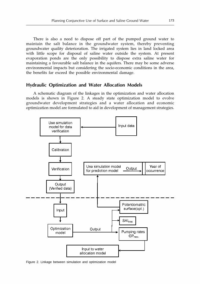
Planning Conjunctive Use of Surface and Saline Ground Water 173
There is also a need to dispose off part of the pumped ground water tomaintain the salt balance in the groundwater system, thereby preventinggroundwater quality deterioration. The irrigated system lies in land locked areawith little scope for disposal of saline water outside the system. At presentevaporation ponds are the only possibility to dispose extra saline water formaintaining a favourable salt balance in the aquifers. There may be some adverseenvironmental impacts but considering the socio-economic conditions in the area,the benefits far exceed the possible environmental damage.
Hydraulic Optimization and Water Allocation Models
A schematic diagram of the linkages in the optimization and water allocationmodels is shown in Figure 2. A steady state optimization model to evolvegroundwater development strategies and a water allocation and economicoptimization model are formulated to aid in development of management strategies.
Figure 2. Linkage between simulation and optimization model

N.K. Tyagi174
Steady-state Flow Optimization Model
The model consists of an objective function and a number of constraints. Theobjective function gives the maximum sustainable pumping yield for the entirearea under well-defined constraints and bounds. The total sustainable pumping isthe sum of individual sustainable pumping of each sub area, which has its localbounds and limits.
The size, number and distribution of the nodal areas and the location of thenatural and arbitrary boundaries of the study area have been decided on the basisof transmissivity, storativity and groundwater levels. Keeping in view the constraintsof quality and availability of basic data, the area was discretized into 30 nodes, ofwhich 15 were internal nodes and the remaining 15 are external nodes (Figure 3).The 15 internal nodes are variable head cells, where the study is being made toevaluate the pumping strategies. The 15 external nodes are primarily required toconstruct the network near the boundaries.
Ideal boundary conditions described do not exist there. A groundwatersimulation study had been conducted in part of the LGB with a view to havepreliminary estimation of the water level fluctuations and behavior (HSMITC,1983). The existing nodal network has been superimposed on the nodal networkused in that study and the boundary conditions have been interpolated. Thewestern boundary of the study area, where a condition of low recharge and lowpumping exists and water levels do not vary throughout the year, is considered aszero flow boundary. On the other three sides, the boundary is assumed to be flowcontrolled.
The steady-state excitation rates are those values of pumping and rechargewhich, when applied to the system, continuously maintain constant potentiometricsurface elevations. For a given set of potentiometric surface elevations, there existsa corresponding set of steady-state pumping values*.
Figure 3. Study area discretized into finite difference cells
*See Tyagi, et al. 1995 for the Mathematical form of model.

Planning Conjunctive Use of Surface and Saline Ground Water 175
The Water Allocation and Economic Optimization Models
The groundwater optimization model described in previous section can beused to determine the optimal levels of groundwater development. Formulation ofa canal and groundwater conjunctive use model is attempted to assist in planningstrategies for water allocation to crop activities. Disposal of saline ground water tomaintain salt and water balance in the crop root zone as well as in aquifer, is anintegral part of the model. The problem is treated as non-linear optimization, anda conjunctive use management model is developed.
The model allocates water to a number of crops according to their sensitivityto saline water to maximize net returns. The income is generated from disposal ofcrop produce while the cost is incurred in purchase of canal and tubewell water.The non-water production inputs are treated as fixed costs. To keep the groundwatersalinity at original level, part of the groundwater pumped is disposed throughevaporation ponds and has a cost. The detailed mathematical formulation can befound in Srinivasulu et al. (1997).
Crop-Water-Salinity Production Function
Crop-water-salinity production functions are essentially the mathematicalrelationships between yield of crop and the amount of applied water and itssalinity. The model requires empirical relations that can be used to study the effectof water quality, quantity and their interaction. The approach used is based oncombining the crop-water-quantity and the crop-water salinity production functions,first proposed by Letey et al. (1985). The crop-water-salinity functions for importantcrops used in this model were developed by Srinivaslu and Tyagi (2001) and aregiven in Table 1.
Table 1. Crop-water-salinity production functions
RY = a+b(AW/Ep)+c(AW/Ep)2+d(Sj)+e(Sj)2+f(AW/Ep)(Sj)
Crop a b c d e f
Wheat -0.1668 1.4465 -0.2947 -0.0071 0.0005 -0.0302
Mustard -0.2718 1.6733 -0.4662 -0.0065 0.0002 -0.0282
Berseem -0.1150 1.2603 -0.1027 -0.0189 0.0024 -0.0958
Cotton -0.2431 2.5401 -1.0751 -0.0087 0.0003 -0.0345
Pearl millet -0.8671 2.9815 -1.0102 -0.0066 -0.0012 -0.0534
Maize -0.4692 2.5843 -0.9030 -0.0142 0.0018 -0.0661
Source: Srinivasulu & Tyagi, 2001
Optimal Ground Water Pumping and Water Allocation Scenarios
The groundwater hydraulic optimization and the conjunctive use managementmodels mentioned in the preceding sections were applied to develop optimal plansfor groundwater development and its use in conjunction with canals for the LGB.In case of groundwater optimization model the data were first prepared for thegroundwater simulation model set for the same area. Tyson and Weber model

N.K. Tyagi176
(1964) as modified by Goodwill (1989) was used. The data screened in the processof calibration of the simulation model were subsequently used in the optimizationmodel. The procedure employed is explained in Figure 2. Possibilities of augmentinggroundwater supplies have been explored through increased stream-aquiferinteraction. Issues concerning sustainability of saline water use have also beenexplored.
Hydraulic Optimization
The model was run for steady state condition using Linear Programming (LP)algorithm written in GAMS. The output from the model include: optimum pumpingrates, resulting potentiometric surfaces and stream-aquifer interaction.
Pumping Rates
The pumping rates for different cells are given in Table 2. It is seen that thereis wide variation in optimal discharge among different cells. The values range from0.25 cumecs to 8.48 cumecs. The pumpable quantities of groundwater dependlargely on recharge opportunity and the type of aquifer. Areas falling along thecourse of rivers and perennial canals have higher opportunity for recharge ascompared to cells or sub areas located away from the river and perennial canals.For example, the river cells 2,2; 2,3; 2,4; 2,5 and 3,1 have pumping rates 4 to 20times of non-stream cells 3,2; 3,3 and 4,1.
Table 2. Values of model outputs
Internal Draw down Saturated Optimal Optimalnodes thickness head pumping
(m) (m) (m) (cumecs)
2,1 1.26 106.66 195.54 2.59
2,2 -8.00 108.53 200.61 7.93
2,3 1.33 102.32 202.62 8.48
2,4 0.67 93.55 210.58 8.10
2,5 1.00 118.76 213.97 2.39
3,1 8.00 112.17 176.56 2.42
3,2 -3.16 100.82 184.32 2.02
3,3 4.27 94.11 195.43 0.85
3,4 7.00 99.64 195.27 1.32
3,5 6.00 109.85 200.53 1.65
4,1 -2.80 135.21 185.81 1.90
4,2 -3.29 127.35 201.25 0.25
4,3 3.77 112.89 192.94 1.50
4,4 1.56 107.72 193.91 1.34
4,5 -0.35 118.19 197.78 1.39
The optimal pumping rates were compared with existing (1985) pumpingrates. It was observed that in the river as well as in the non-river cells, the existing

Planning Conjunctive Use of Surface and Saline Ground Water 177
pumping rates are much lower than optimal pumping rates. As expected, the rivercells have higher current pumping rates. The magnitude of the difference betweenoptimal and current pumping rate varies from less than 0.5 cumecs to more than8 cumecs. This difference in potential and current pumping rates is responsible forrise in water table.
Potentiometric Surface
Potentiometric surfaces have several implications for ground water management.If the surfaces will be high, it will lead to waterlogging resulting in directevapotranspiration from soil surface and cause salinity. If the potentiometricsurfaces are very low, the pumping cost may be high for economic exploitation ofgroundwater. Further, in areas where groundwater quality problem occurs, thequality deteriorates with depth (in most cases). Therefore, decisions about desiredpotentiometric surfaces have to be chosen with care. The existing potentiometricsurfaces have values between 185 m to 216 m above mean sea level (MSL) and thecorresponding depth to water table is within 4 to 17 m (Figure 4). In areas wherethe average depth to water table is within 4 to 5 m, such as those represented bycell 2,1; 2,3, part of the area suffers from high water table and salinity. The resultsfrom groundwater simulation model (Tyagi et al., 1996) indicated that the watertable had a rising trend with rates varying 0.22 to 0.60 m/year. It means, thoughat present the water table is below the critical levels, in the absence of groundwaterdevelopment, it may become critical at some future date.
Figure 4. Depth to water table in maximization scheme
The optimal potentiometric surfaces, that have been obtained with theapplication of model fall in the range of 184 to 214 m above MSL giving a depthof water table 4 to 22 m. It is observed from the depth to water table graph (Figure4) that under the steady-state situation the water table would fall below theexisting level by 2 to 7 m, except in case of cell 2,2; 3,2; 4,1; 4,2 and 4,5 where thewater table would come up. The maximum difference in initial and steady-state
22
20
18
16
14
12
10
8
6
4
21 23 25 31 33 35 41 43 45Nodes
Dep
th t
o w
ater
tab
le (
m)
InitialSteady

N.K. Tyagi178
water table is 8 m in cell-3,1 whereas the minimum difference is 1 m in case of cell-2,4. The cells-2,2; 2,3; 2,4 and 2,5 are river cells with high pumping rates. In spiteof higher pumping rates the draw down are low because of continuous rechargefrom the river and perennial canals. However, in case of cell 3,1, which is also rivercell, the draw down is maximum (8 m) though the steady-state pumping rate forthe cell is only one-third of the other river cells such as cell- 2,2; 2,3 and 2,4. Thiscell lies in area where there is an abrupt fall in the riverbed elevation. Since thesurface water body in the form of left and right Ghaggar canals are at higherelevation, the water table around this area is higher than river bed and contributesto sub-surface flow into the river. The saturated thickness of the aquifer in thewhole region is in the range of 93.50 m to 135.20 m. In the model, a constraint hasbeen put on the maximum draw down (lowering of water table from initial level),which would not allow the water table to fall more than 50 percent of saturatedthickness of the aquifer.
Stream-Aquifer Interaction
Stream-aquifer interaction (SAI), which may involve flow from aquifer tostream or vice-versa is an integral part of the model. As has been indicated earlier,the possibility of SAI exists in areas, having large or perennial flowing surfacewater bodies such as river, canal and ponds. The magnitude of SAI is determinedby the hydraulic head difference between water bodies and aquifer, and theconductance of the transmitting medium. On the basis of the available water tableelevations and the elevation of surface water body, and the conductance, thecurrent SAI i.e. flow to and from the water body were determined. As the pumpingincreases the head differential between surface water bodies and groundwatertable level also increases, facilitating higher SAI. In case of maximized scheme, thetotal SAI is 26.08 cumecs as compared to current interaction of 20.81 cumecs (Table3). In case of minimized pumping scheme, which maintains water table 3 m in theentire area, the SAI reduces to 21.92 cumecs. The increase of about 25% in SAI atmaximized pumping rates indicates the feasibility of generating more waterresources from river flow, which at present goes waste and creates waterloggingproblem at tail end of the Ghaggar depressions in Rajasthan.
Pumping Scheme
Meeting the maximized pumping rate would require a large number oftubewell units. In this area, shallow tubewells and pump sets are frequently used.At present, the number of tubewell units is few and they are sparsely spaced. Inorder to obtain the optimized potentiometric surfaces, the differences betweencurrent pumping units and the optimally required pumping units must be reduced.The average pumping rates of shallow tubewells vary from 4 lps to 8 lps (HSMITC,1983). The operation time of shallow tubewells in the area is 10 hours a day forabout 100 days in a year (HSMITC, 1984). In case of maximized pumping schemethe number of pumping units is around 8 times of units existing in 1985. Recentestimates show that the number of pumping units has more than doubled: from37,262 in 1985 to 82,682. The pumping units have to be increased in all the cells,though larger increase is required in river or canal cells. It should be understoodthat for all tubewell discharges (4-8 lps), the number of tubewells per unit area is
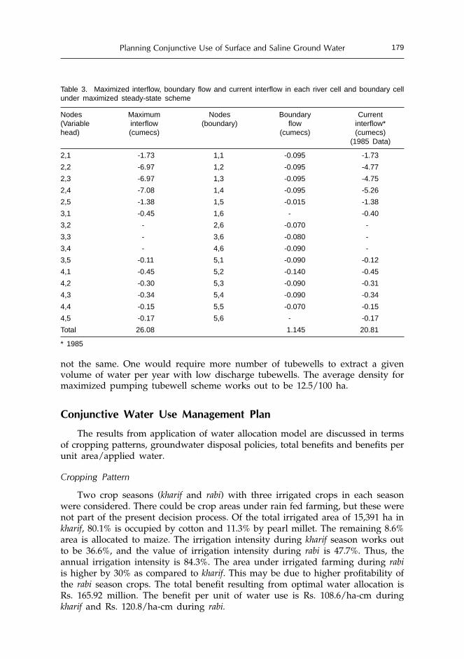
Planning Conjunctive Use of Surface and Saline Ground Water 179
not the same. One would require more number of tubewells to extract a givenvolume of water per year with low discharge tubewells. The average density formaximized pumping tubewell scheme works out to be 12.5/100 ha.
Conjunctive Water Use Management Plan
The results from application of water allocation model are discussed in termsof cropping patterns, groundwater disposal policies, total benefits and benefits perunit area/applied water.
Cropping Pattern
Two crop seasons (kharif and rabi) with three irrigated crops in each seasonwere considered. There could be crop areas under rain fed farming, but these werenot part of the present decision process. Of the total irrigated area of 15,391 ha inkharif, 80.1% is occupied by cotton and 11.3% by pearl millet. The remaining 8.6%area is allocated to maize. The irrigation intensity during kharif season works outto be 36.6%, and the value of irrigation intensity during rabi is 47.7%. Thus, theannual irrigation intensity is 84.3%. The area under irrigated farming during rabiis higher by 30% as compared to kharif. This may be due to higher profitability ofthe rabi season crops. The total benefit resulting from optimal water allocation isRs. 165.92 million. The benefit per unit of water use is Rs. 108.6/ha-cm duringkharif and Rs. 120.8/ha-cm during rabi.
Table 3. Maximized interflow, boundary flow and current interflow in each river cell and boundary cellunder maximized steady-state scheme
Nodes Maximum Nodes Boundary Current(Variable interflow (boundary) flow interflow*head) (cumecs) (cumecs) (cumecs)
(1985 Data)
2,1 -1.73 1,1 -0.095 -1.73
2,2 -6.97 1,2 -0.095 -4.77
2,3 -6.97 1,3 -0.095 -4.75
2,4 -7.08 1,4 -0.095 -5.26
2,5 -1.38 1,5 -0.015 -1.38
3,1 -0.45 1,6 - -0.40
3,2 - 2,6 -0.070 -
3,3 - 3,6 -0.080 -
3,4 - 4,6 -0.090 -
3,5 -0.11 5,1 -0.090 -0.12
4,1 -0.45 5,2 -0.140 -0.45
4,2 -0.30 5,3 -0.090 -0.31
4,3 -0.34 5,4 -0.090 -0.34
4,4 -0.15 5,5 -0.070 -0.15
4,5 -0.17 5,6 - -0.17
Total 26.08 1.145 20.81
* 1985

N.K. Tyagi180
Water Allocation
Of the total water supply from canal and groundwater, 588,000 ha-cm is usedduring kharif and 959,345 ha-cm during rabi. During kharif, cotton is allocated 83.1%of the total water and the remaining is shared almost equally between pearl milletand maize. During rabi, major share of saline groundwater goes to mustard(50.3%), followed by wheat (41.4%) and berseem (8.2%). In the existing allocation,wheat receives more than 60% of water supply.
Ground Water Disposal
The sustainability of irrigated agriculture depends on keeping groundwatertable and its quality within the permissible range. Whereas it is possible to keepwater table within acceptable limits by groundwater development and its usewithin the basin, it is not so with ground water quality. The groundwater qualitycan be maintained at the existing level only if salt input and output are kept fullybalanced. Along with water allocation to crops, the model also computes theground water to be pumped and the volume of groundwater to be disposed indifferent quality zones. As per the constraints imposed in the model, 625,345 ha-cm ground water is pumped annually. This is, 15% more than the average annualrecharge. Of the total ground water pumped, 86,000 ha-cm is disposed throughevaporation ponds. This is about 13.8% of the total ground water pumped.
All the water of 0-4 dS/m range is used for irrigation and the waters of 4-6 dS/m and >6 dS/m range are disposed through evaporation ponds. The fraction of thegroundwater disposed through the evaporation ponds increases with increase inground water salinity. This has got two implications: (i) better water quality ismore beneficial for irrigation, and (ii) disposal of higher salinity water throughevaporation permits maintaining salt balance in the basin with relatively lowerdisposal volumes. It should, however be understood that in this analysis the entireground water basin has been treated as one. If it is disaggregated, then one willhave to determine groundwater evacuation and disposal from individual cell.
Table 4. Net benefit per unit water use and water disposal as affected by ground water salinity (SG)
Item At 2 SGo 3 SGo 4 SGo
existing Salinity (SGo)
Net benefit (106 Rs.) 179.94 166.75 163.86 159.27
Water used (103 ha-cm) 1547.35 1575.42 1591.58 1602.05
Net benefit per unit water use (Rs./ha-cm) 116.16 111.76 107.18 102.55
Ground water disposal (103 ha-cm) 58856.00 39649.00 28589.00 21441.00
Sustainability of Saline Ground Water Use
It is possible to maintain water table at the prescribed level without groundwaterdisposal by adjusting groundwater pumping. However, it is not a practice that canbe sustained on long-term basis. In the absence of disposal, the salt load in thegroundwater reservoir will continue to increase and after sometime the negativeeffects of rise in groundwater salinity will start appearing in the form of reducedyields and lower net benefits. In order to evaluate the level of groundwater salinity,

Planning Conjunctive Use of Surface and Saline Ground Water 181
at which the cost of disposal and benefits from increased availability of groundwater without disposal will balance yield and income reductions, the model wasrun at various groundwater salinity levels. The resulting benefits from water usewithout disposal were compared with benefits occurring with ground waterdisposal at various salinity levels (Figure 5).
It may be seen that the benefits from optimization scheme without disposalwere higher than benefits with disposal upto a salinity level nearly 4.1 times thatof original salinity. It has got the following implications from the viewpoint ofoperation and management of saline ground water in conjunction with canalwater:(1) Investment on disposal in the form of evaporation ponds can be deferred till
such a time, that the yield losses from increased groundwater salinity nearlybalance the cost of disposal. The duration for which, investment can bedeferred will depend upon the original salinity of the ground water, rainfallamount, and its distribution, canal water quality and quantity.
(2) The level of investment in groundwater disposal through evaporation pondshould be less than or equal to the annual reduction in net benefits.
(3) Whereas lowering of water table and keeping it below critical levels is anecessary condition for sustainable conjunctive use of fresh and saline waters,it is not a sufficient condition. The sufficiency is provided by salt disposal only.
Concluding Remarks
The application of groundwater simulation and optimization models in thispaper is based on data, which was available at a large irregular grids.The availabilityof hydro- geologic data on micro-scale is desirable not only for better predictionbut also for development of saline ground water aquifers, which exhibit large
Figure 5. Net benefit with and without disposal at various levels of ground water salinity (SG)
Net
ben
efit,
106
Rs.
n SGo
Without disposalWith disposal
192
176
160
1440 1 2 3 4 5

N.K. Tyagi182
spatial variability. The development and use of ground water in the study area,part of which is saline in nature, in conjunction with canal water is providingopportunity of increasing production and minimizing risk of water logging. Therehas been more than 230% increase in groundwater development since the studywas first undertaken in the late eighties, but the full advantage that would occurfrom inducing recharge in Ghaggar River bed, has not been taken. The developmentof higher salinity water continues to be low due to several technological andeconomic constraints. Efforts would be needed both at farmers’ level, as well as, atgovernment level to realize the potential gains of conjunctive water management.Maybe, introduction of brackish aquaculture could promote higher salinity groundwater development.
References
Abrol, I.P., Tyagi, N.K. and Tanwar, B.S. 1988. Conjunctive use of water resources: problems, prospectsand experiences in Haryana, In: Proc. National Seminar on Water Management-the Key toDevelopment of Agriculture, (ed. J.S. Kanwar), Agricole Publishing Academy, INSA, April, 28-30,1986, New Delhi, 1: 197-238.
Goodwill, I.M. 1989. Consultant report, Advanced Centre of Post Graduate Education and Research onIrrigation Management (ICAR-UNDP), Central Soil Salinity Research Institute, Karnal, India,p.25.
Hall, W.A. 1986. Principles of conjunctive use in water resources planning and management. In: Proc.Seminar on Conjunctive use of Surface and Ground water Resources, 10-13 February, 1986,Central Ground water Board, New Delhi, 99: 1-19.
Helweg, O.J. and Labadie, J.W. 1976. Accelerated salt transport method for managing ground waterquality. Water Resour. Res., 12: 681-693.
H.S.M.I.T.C., 1983. Mathematical model study for management and optimization of ground water inLower Ghaggar Basin, Haryana State Minor Irrigation & Tubewell Corporation (HSMITC),Chandigarh, India.
H.S.M.I.T.C., 1984. Appraisal document on studies for use of saline water in the canal command areaof irrigation projects, Haryana, HSMITC, Chandigarh, India.
Khepar, S.D. and Chaturvedi, M.C. 1982. Optimum cropping and ground water management. WaterResour. Bull., 18: 655-660.
Knapp, K.C. and Wichelns, D. 1990. Dynamic optimization for salinity and drainage management. In:Agricultural Salinity Assessment and Management (ed. K.K. Tanji), ASCE, New York, NY.
Lefkoff, L.J. and Gorelick, S.M. 1990. Simulating physical processes and economic behaviour in salineirrigated agriculture: model development. Water Resour. Res., 26: 1359-1369.
Letey, J., Dinar, A. and Knapp, K.C. 1985. Crop-water-production function model for saline irrigationwaters. Soil Sci. Soc. Am. J. 49: 1005-1009.
Srinivasulu, A., Tyagi, N.K. and Shukla, K.N. 1997. Conjunctive use of water resources in saline groundwater basins: A management model, Journal of International Commission on Irrigation andDrainage, 46(1): 65-84.
Srinivasulu, A. and Tyagi, N.K. 2001. Crop-water-salinity production functions for planning salinewater use. Journal of Institution of Engineers - Agril. Engg. Division, 82(1): 1-4.
Tyagi, N.K. 1987. Managing salinity through conjunctive use of water resources, Ecological Modelling,40: 11-24.
Tyagi, N.K., Tyagi, K.C., Pillai, N.N. and Willardson, L.S. 1993. Decision support to irrigation systemimprovement in saline environment, Agricultural Water Management 19(4): 285- 301.
Tyagi, N.K., Srinivaslu, A., Kumar, A. and Tyagi, K.C. 1995. Conjunctive use of water resources:Hydraulic and economic optimization, Central Soil Salinity Research Institute, Karnal, BulletinNo. 6/95, p.86.
Tyson, H.N. and Weber, E.M. 1964. Ground water management for the nations future. Computersimulation of ground water basin. Jr. Hydraulic Division of ASCE 90 (HV-4): 59-78.
Zeng, L., Shannon, M.C. and Lesch, S.M. 2001. Timing of salinity stress affects rice growth and yieldcomponents, Agric. Water Management. 48: 191-206.

Management Options and Policy Guidelines forUse of Poor Quality Groundwater in Agriculture
D.R. Sharma and P.S. MinhasCentral Soil Salinity Research Institute, Karnal, India
Abstract
The anticipated shortage of fresh water supply to agriculture sector in the 21st centuryis likely to enhance globally the utilization of relatively poor quality water for irrigation.The poor quality ground waters occur extensively (32-84%) in the arid and semi-arid partsof India and their indiscriminate use poses serious threat to the sustainability of naturalresources and environment. Water quality studies over past few decades have enableddevelopment of technological options to cope up with the problems of saline and sodic wateruse. Possibilities have now emerged to safely use water otherwise designated unfit. Theseoptions primarily consist of: i) selection of crops, cropping patterns and crop varieties thatproduce satisfactory yields under the existing or predicted conditions of salinity andsodicity ii) appropriate irrigation scheduling and conjunctive use options with canal water;rain water management and leaching strategies to maintain a high level of soil moisture,and low level of salts and exchangeable sodium in the rhizosphere, and iii) use of landmanagement practices to increase the uniformity of water distribution, infiltration, and saltleaching besides the optimal use of chemical amendments including time and mode of theirapplication with judicious use of organic materials and chemical fertilizers. Some of thepolicy guidelines such as establishing water quality monitoring networks, modifications incanal water delivery schedules, groundwater pumping pricing, subsidies on amendmentsand micro-irrigation systems, promoting conjunctive use and ground water recharging andtraining need for farmers and extension workers are also highlighted.
Introduction
The availability of fresh water supplies to agriculture sector in future is likelyto reduce world over particularly in the Asian countries due to populationpressure, improved living standards and inter-sector competition for water. Theestimate for India shows this reduction to be 10 to 12% by 2025.
In the back drop of this grim water scenario, the agriculture sector would beleft with no other alternative than to use poor quality water sources to meet theirrigation requirements. The ground water surveys in India indicate that poorquality water being utilized in different states range between 32 to 84% of totalground water development. Many more areas with good quality aquifers are

D.R. Sharma and P.S. Minhas184
endangered with contamination as a consequence of excessive withdrawl of groundwater. The ground water of arid region are largely saline and of semi-arid regionare sodic in nature.
Indiscriminate use of poor quality water for irrigating agricultural cropsdeteriorates the productivity of soils through salinity, sodicity and toxic effects. Inaddition to reduced productivity, the use of poor quality water deteriorates thequality of produce and also limits the choice of cultivable crops. Nevertheless,concerted efforts at different research centers located in different agro climaticzones of the country have yielded valuable concepts and viable technologies for thesustainable irrigation with poor quality water (Minhas, 1996). Possibilities haveemerged to safely use water otherwise designated unfit if the characteristics ofwater, soil and intended crops are known. However, appropriate selection of crops,improved water management and maintenance of soil structure permeability arenecessary for sustaining irrigation with these waters. In this paper we haveoutlined various technological and policy options available for alleviating hazardsof salt-affected water and maximizing productivity form their sustained use.
Classification of Irrigation Water
Irrigation waters are mainly classified on the basis of electrical conductivity(EC), sodium adsorption ration (SAR) and residual sodium carbonate (RSC).However, from management point of view, ground water utilized in differentagro-ecological regions can be broadly grouped into three classes: good(A), saline(B)and alkali/sodic(C). Depending on the degree of restriction, each of the two poorquality water classes has been further grouped into three homogenous subgroups(Table 1).
Table 1. Classification of poor quality ground water
Water quality ECiw SARiw RSC(dS m-1) (mmol-1)½ (meq l-1)
A. Good <2 <10 <2.5
B. Saline
i. Marginally saline 2-4 < 10 <2.5
ii. Saline > 4 < 10 <2.5
iii. High-SAR saline > 4 > 10 < 2.5
C. Alkali water
i. Marginal alkali <4 <10 2.5-4.0
ii. Alkali <4 <10 >4.0
iii. Highly alkali variable >10 >4.0
Poor Quality Ground Water Resources
In India so far, no systematic attempts have been made to arrive at the estimateof poor quality ground water resources. However, some predictions about use ofpoor quality water in various states are given in Table 2. The CGWB (1977)

Guidelines for Use of Poor Quality Groundwater in Agriculture 185
approximated that the total area underlain with the saline ground water (EC>4 dSm-1) is 193,438 km2 with the annual replenishable recharge of 11,765 M m3 Yr-1,leaving aside minor patches.
Table 2. Use of Poor quality ground water in various states of India
State Utilizable ground Net draft Level of Use of Area underlainwater resources (M ha-m yr-1) ground water poor quality by salinefor irrigation in development water (EC>4dSm-1)
net terms (%) (M ha-m Yr-1) (km2)(M ha-m Yr-1)
Punjab 1.47 1.67 98 0.68 3058
Haryana 0.86 0.72 76 0.47 11438
Uttar Pradesh 6.31 2.98 42 1.42 1362
Rajsthan 0.95 0.77 73 0.65 141036
Bihar 2.06 0.82 36 NA NA
West Bengal 1.77 0.63 32 NA NA
Delhi 0.01 0.01 120 NA 140
Gujarat 1.56 0.85 49 0.26 24300
Karnataka 1.24 0.45 33 0.17 8804
Tamilnadu 2.02 1.40 63 NA 3300
Madhya Pradesh 2.66 0.73 25 0.20 NA
Maharashtra 2.29 0.88 35 NA NA
Andhra Pradesh 2.70 0.78 26 0.25 NA
Total (India) 32.63 13.50 37 193438
Source: Minhas et al., 2004
Management Options for Saline Water Use
Research studies at various centers in different agro-climatic zones of thecountry have yielded valuable concepts and viable technologies for the sustainableirrigation with poor quality water. It has been established that the success withpoor quality water irrigation can only be achieved if factors such as rainfall,climate, water table, and water quality characteristics, soils and crops are integratedwith appropriate crop and irrigation management practices. The availablemanagement options mainly include irrigation, crop, chemical and other culturalpractices but there seems to be no single management measure to control salinityand sodicity of irrigated soil. Instead several management practices interact witheach other and should be considered in an integrated manner. In this paper,however, different management options have been described separately as under.
Crop Management
Selection of Crops
For successful utilization of saline water, crops which are semi-tolerant totolerant such as mustards, wheat and cotton as well as those with low water

D.R. Sharma and P.S. Minhas186
requirement are recommended. Crops such as rice, sugarcane and berseem, whichrequire liberal water use, should be avoided. In low rainfall areas (<40 cm/annum),mono–cropping is recommended for maintaining salt balances. Salt tolerance limitsof cereals, oil seeds, vegetables, and pulses developed in different ecologicalregions of India are available in Table-3. The choice of crops for a given soil andwater salinity condition can be made from this data. Some other specificrecommendations related to crop selection and management are as under:
Table 3. Salinity limits of irrigation water for agricultural crops
Crops Soil texture Pervious crop ECiw (dS/m) for yield (%)
90 75
Cereals
Wheat Silty clay loam Sorghum 3.4 7.0
Sandy loam Bajra 6.6 10.4
Loamy sand Fallow 8.3 11.7
Sand Fallow 14.0 16.1
Barley Sandy loam Fallow 7.2 11.3
Rice Silty clay loam Rice 2.2 3.9
Maize Clay loam Wheat 2.2 4.7
Pearl-millet Sandy loam Wheat 5.4 9.0
Italian-millet Sand Sunflower 2.4 4.6
Sorghum Sandy loam Mustard 7.0 11.2
Sorghum fodder Sandy loam Berseem 5.2 10.2
Oilseeds
Mustard Sandy loam Sorghum 6.6 8.8
Safflower Silty clay loam Maize 3.3 6.8
Sunflower Sandy loam Mustard 3.5 7.2
Groundnut Sand Italian-millet 1.8 3.1
Soyabean Silty clay loam Mustard 2.0 3.1
Pulses/Legumes
Pigeon pea Sandy loam Onion 1.3 2.3
Clusterbean Sandy loam Variable 3.2 4.5
Cowpea Loamy sand Variable 8.2 13.1
Berseem Sandy loam Sorghum 2.5 3.2
Vegetables
Onion Sandy loam Pigeonpea 1.8 2.3
Potato Sandy loam Okra 2.1 4.3
Tomato Sand Variable 2.4 4.1
Okra Sandy loam Potato 2.7 5.6
Chillies Sand Variable 1.8 2.9
Brinjal Sand Variable 2.3 4.1
Fenugreek Sandy loam Potato 3.1 4.8
Bitter gourd Sand Variable 2.0 3.4
Bottle gourd Sand Variable 3.2 4.5

Guidelines for Use of Poor Quality Groundwater in Agriculture 187
Growth stages: All crops do not tolerate salinity equally well at different stagesof their growth. For example, germination and early seedling establishment are themost critical stages followed by the phase changes from vegetative to reproductivei.e. heading and flowering to fruit setting. Therefore, the use of saline water shouldbe avoided during initial stages of crop growth.
Crop cultivar: In addition to intergenic variations, crop cultivar also vary intheir tolerance to salinity. Such cultivars have been identified on their rating forhigh yield potential, salt tolerance and stability under saline environments and areincluded in Table 4.
Table 4. Promising cultivars for saline and alkaline environments
Crop Saline environment Alkali environment
Wheat Raj 2325, Raj 2560, Raj 3077, WH 157 KRL 1-4, KRL19, Raj 3077, HI1077,WH 157
Pearl-millet MH269, 331, 427, HHB-60 MH 269, 280, 427, HHB 392
Mustard CS416,CS330,-1, Pusa Bold CS15, CS52, Varuna, DIRA 336, CS 54
Cotton DHY 286, CPD 404, G 17060, GA, HY6, Sarvottam, LRA 5166JK276-10-5, GDH 9
Safflower HUS 305, A-1, Bhima Manjira, APRR3, A300
Sorghum SPV-475, 881, 678, 669, CSH 11 SPV 475, 1010, CSH 1, 11, 14
Barley Ratna, RL345, RD103, 137, K169 DL4, 106, 120, DHS 12
Cropping sequence: Cropping sequence is another critical step in mitigatingsaline conditions. The recommended cropping sequence for saline conditions arepearl millet –barley, pearl millet-wheat, pearl millet-mustard, sorghum-wheat orbarley-sorghum-mustard, cluster bean – wheat or barley and cotton- wheat orbarley. The pearl millet-wheat, pearl millet-barley, pearl millet-mustard, sorghum(fodder)-wheat and sorghum (fodder)-mustard cropping sequences are moreremunerative in saline soils. Cotton based cropping sequence are not beneficialsince the yield of the winter crops that follow cotton are usually low. In areas withwater scarcity, mustard could replace wheat in the cropping sequence since itswater requirement is low compared to wheat.
Ionic Composition Effects
Chlorides, being more toxic tend to reduce the tolerance limits of crops to theuse of saline water by 1.2 – 1.5 times as compared with sulphate rich water(Manchanda, 1998). Similarly, more salts tend to accumulate in soils when irrigatedwith water of high SAR and thus tend to reduce the limits of saline water use.
Tree Species
In cases where it is neither feasible nor economical to use saline water for cropproduction, such water can be used to raise tree species especially on lands thoseare already degraded. The preferred choice of species should be Azadirachta indica,Acacia nilotica, A. tortilis, A. farnesiana, Cassia siamea, Eucaluyptus tereteerms, Feronialimonia, Prosopis juliflora, P. cineraria, Pithecellobium dulce, Salvadora persica, S. oleoides,Tamarix.

D.R. Sharma and P.S. Minhas188
Medicinal Plants
Some medicinal plant such as Isabgol (Plantag oovata), Aloe and Kalmeg havealso been found promising under saline irrigation conditions as an alternative toarable crops.
Water Management
Irrigation and Leaching Management
As each irrigation with saline water results in addition of a certain amount ofsalts to the soil, salts may gradually accumulate in the root-zone to detrimentallevels and cause reduction in crop yields if no leaching takes place. However,proper irrigation and leaching practices can prevent excessive accumulation of saltsin the root zone. The following suggestions may be helpful.• Arid areas would need 15 to 20 percent more water to be applied as irrigation
for meeting out the leaching requirements. To maximize the benefit fromenhanced quantity of irrigation water, attempts should be simultaneouslymade to minimize the water applied i.e. saline irrigation should be appliedmore frequently. Nevertheless, in areas with rainfall more than 400 mm andhaving monsoon type of climate, no extra leaching is usually required and theconventional irrigation practices may be followed. In the years of sub-normalrainfall, a heavy pre-sowing irrigation with saline water should be applied sothat the salts accumulated during the preceding rabi season are pushed beyondthe root-zone.
• The distribution of water and salts in soils vary with the method of irrigation.A shift towards micro-irrigation systems such as drip and sprinklers, where abetter control on salt and water distributions can be achieved, hold promise forenhancing the use efficiency of saline water especially for high value crops(Table 5). Pre-emergence application of saline water through sprinklers, helpsto keep soluble salt concentrations low in seedbed during germination andthus better establish the crop. Some of the indigenous alternative to drips onmicro scale are the use of pitchers and specially designed earthen pots,however their feasibility on field scale remain untested.
• In the case of saline water logged soils provided with sub-surface drainage, thesystem can be beneficially employed to induce crop water use from shallowwater table through controlled drainage in rabi crops and thus reduce therequirement of irrigation water.
Conjunctive Use of Saline and Canal Water
Often water of more than one quality is available at the same location. Onesuch situation commonly arises when farmers have access to limited supplies ofcanal water along with saline ground water. The existing fresh and saline watersupplies could be suitably combined in several ways. First option is to blend thetwo supplies such that the salinity attained after mixing is within the permissiblelimits of crop tolerance. The mixing of two water supplies from canal and tubewellalso helps in improving the stream size and thus enhances the uniformity ofirrigation especially in sandy soils.

Guidelines for Use of Poor Quality Groundwater in Agriculture 189
• Application of the two waters separately, if available on demand, can be doneeither to different fields, seasons or crop growth stages so that the highersalinity water is avoided at sensitive growth stages of the crops. As thegermination and seedling establishment stages have been identified as thesensitive stages in most crops, better quality water should be utilized for pre-sowing irrigation and early stages of crop growth. Then a switch over to poorquality water can be made when the crops can tolerate higher salinity. In theseasonal cyclic use, non-saline water is used for salt sensitive crops or in theinitial stages of tolerant crops to leach out the accumulated salts from irrigationwith salty water to previously grown tolerant crops. Cyclic uses i.e. irrigatingwith water of different qualities separately offers both operational andperformance advantages over mixing.
• For skimming of fresh water floating over seawater in coastal sandy soils,conventional “Dorouv” system has been improved with specially designed sub-surface water harvesting system that can irrigate up to 3-5 ha land (Raghu-Babu, 1999).
Nutrient Management
Fertilizers
Application of fertilzers is important for obtaining good yields with salineirrigation.• Response to applied nitrogen is rather reduced under saline irrigation. Thus,
additional doses of nitrogenous fertilisers, though do not materially changesalinity tolerance but are recommended to compensate for volatilisation losses.
• Soils irrigated with chloride rich water respond to higher phosphate application,because the chloride ions reduce availability of soil phosphorus to plants. The
Table 5. Yield and water use efficiency under different irrigation methods
Crop Average yield (Mg ha-1) for irrigation method
Surface method Sprinkler method
CW* SW* CW SW
Wheat (1976-79) 4.00 (97)** 3.62 (83) 3.69 (107) 3.54 (97)
Barley (1980-82) 3.51 (147) 2.32 (98) 3.48 (159) 2.59 (117)
Cotton (1980-82) 2.30 1.71 2.28 1.34
Pearl millet (1976-78) 2.38 2.07 2.54 1.50
Drip Method
Surface Subsurface Furrow
Radish (ECwater 6.5 dS m-1) 15.7 (17.5) 23.6 (26.2) 9.9 (8.7)
Potato (4 dS m-1) 30.5 (93.5) 20.8 (78.5) 19.2 (53.6)
Tomato (10 dS m-1) 59.4 43.9
Tomato (4 dS m-1) 42.6 36.9
*CW- Canal water, SW-Saline water** Figure in parenthesis denote water use efficiency (Kg/ha-cm).Source: Aggarwal and Khanna (1983); Singh et al. (1978); AICRP-Agra (2002)

D.R. Sharma and P.S. Minhas190
requirement of the crop for phosphoric fertilizers is, therefore, enhanced andnearly 50 per cent more phosphorus than the recommended dose undernormal conditions should be added, provided the soil tests low in availablephospourous.
• For sulphate rich water, no additional application of phosphatic fertilisers isrequired and the dose recommended under normal conditions may be applied.
• For micro-nutrients such as zinc, the recommended doses based on soil testvalues should be applied.
Farmyard Manure (FYM)
FYM and other organic manures not only have the nutritive value, they alsoplay an important role in structural improvements. This further influences leachingof salts and reduce their accumulation in the root zone. The other advantage ofFYM in saline water irrigated soils are in terms of reducing the volatilisation lossesand enhancing the nitrogen-use efficiency. Retention of nutrients in organic formsfor longer periods also guards against leaching and other losses. In the context ofthe advantages of FYM and other organic manure, they should be applied to themaximum possible limit.
Cultural Practices
Owing to reduced germination, often a poor crop stands in fields irrigated withsaline water. Thus, to ensure better populations following measures are suggested:• Reduce inter/intra row spaces and use 20-30% extra seed than under normal
conditions.• Dry seeding and keeping the surface soil moist through sprinkler or post-
sowing saline irrigation helps in better establishment of crops.• Modifications in seedbed e.g. sowing near the bottom of the furrows on both
sides of the ridges, applying irrigation in alternate row, and to seed on thenorth-east side of the ridges, is recommended. For the larger seeded crops, theseeds can be planted in the furrows. The furrow irrigation and bed plantingsystem (FIRB) has been found better than conventional planting in cotton /pearl millet –wheat rotations.
• Adoption of measures for better intake of rainwater (tillage to open up soil)and its conservation in soil via checking unproductive evaporation losses (soil/straw mulching) is recommended during monsoon season.
Management Options for Use of Alkali Water
Consistent efforts have been made at different research centers in the countryto devise ways for the safe utilization of sodic water to raise agricultural crops.With scientific advances, the basic principles of soil-water-plant systems are nowfairly well understood and advocate specialized soil, crop and irrigation managementpractices for preventing the deterioration of soil to levels which limit the cropproductivity. Some such management measures for controlling the built up of ESPand maintaining the physical and chemical properties of sodic water irrigated soilsare being discussed below.

Guidelines for Use of Poor Quality Groundwater in Agriculture 191
Land Levelling and Rain Water Conservation
Proper land levelling and provision of 30-40 cm high strong bunds forcapturing and retaining rainwater are the essential prerequisites for managing theland irrigated with sodic water. The surface soil should be protected againstbeating action of raindrops, which can be achieved through ploughing the field inbetween rains. This practice, besides increasing intake of rainwater helps incontrolling the unproductive losses of water through weeds and evaporation.These practices also promote uniform salt leaching and self-reclamation throughthe dissolution of soil calcium carbonate.
Crop Selection
The guiding principle for choosing the right kind of crops and croppingpatterns suitable for a particular sodic water is to select only those crops whosesodicity tolerance limits are lower than the expected soil sodicity (ESP) to bedeveloped by the use of that water. Under average conditions of water use, theexpected root zone sodicity can be approximated by 1.5 ´ SARiw in fallow- wheat,2.0 ´ SARiw in millet- wheat and 3.0 ´ SARiw in rice-wheat cropping sequences.Thus, based on the expected ESP to be developed, the suitable crops can be chosenfrom the list of sodicity tolerant crops given in Table 6 & 7. Since use of sodic waterrequires repeated application of gypsum, it is advisable to select only tolerant andsemi tolerant crops and their varieties having low requirements of water such asbarley, wheat, mustard, oats, bajra and sorghum. The choice of promising cultivarscan be made from the list given in Table 4. The other guidelines pertinent toselecting crops suitable for sodic water are :• In low annual rainfall areas (< 400 mm) if the good quality canal water is not
available, it is advisable to keep the fields fallow during kharif season. Duringrabi, only tolerant and semi-tolerant crops such as barley, wheat and mustardshould be grown.
• For areas having rainfall >400 mm per annum, jowar-wheat, guar-wheat, bajra-wheat and cotton-wheat rotations can be practised, provided it is ensured thatsowing, particularly of kharif crops is done with rain water or good qualitycanal water. Besides, not more than 2 to 3 irrigations should be applied withsodic water in the kharif.
• For areas having annual rainfall >600 mm in the rice-wheat belt of alluvialplains, rice-wheat, rice-mustard, sorghum-mustard, and dhainacha (green maure)-wheat rotations can be practiced with gypsum application.
• Alternating sodic water use between moderate water requiring crop rotationand a low water requiring crop helps in checking faster sodicity developmentby RSC bearing water.
• Sodic water should not be used for growing summer crops in the month ofApril to June.

D.R. Sharma and P.S. Minhas192
Use of Amendments
Sodic water can be safely and economically used after treating them withcalcium bearing amendment such as gypsum. The agricultural grade gypsum caneither be added to soil or applied in water through specially designed gypsumbeds. Both methods are equally effective in neutralizing the RSC of water and itsadverse effects. Acidic amendment like pyrites can also be used for amending thedeleterious effect of high RSC water both as soil application and as pyrite bed. Thequantity of gypsum applied should be known based on the analysis of water andirrigated soil. It depends on the RSC of water, extent of soil deterioration, and thewater requirements of the intended crops and cropping system. However, followingguidelines can be of additional help in deciding the need and quantity ofamendments required for different sodic water use situations:
Gypsym Application
• Gypsum is generally not needed on well-drained light textured soils in fallow-wheat rotation. In double cropping, however, its application at the rate of 25%- 100% Gypsum Requirment (GR) of water has been reported to boost cropyields (Manchanda, et. al. 1985). Yadav et al. (1991) in another study hasreported that addition of gypsum at the rate of 50% gypsum requirement of aloamy sand soil was found sufficient to grow even the sensitive kharif cropslike pearl millet, moongbean, urdbean, cowpea and clusterbean in the presenceof 600 mm rainfall.
Table 6. Relative tolerance of different crops to sodicity of soils
ESP Range* Crops
10-15 Safflower, peas, lentil, pigeon pea, urdbean, banana
16-20 Bengal gram, soybean, papaya, maize, citrus
20-25 Groundnut, cowpeas, onion, pearl-millet, guava, beal, grapes
25-30 Linseed, garlic, guar, palma rosa, lemon grass, sorghum, cotton
30-50 Mustard, wheat, sunflower, ber, karonda, phalsa, vetiver, sorghum, berseem, senji
50-60 Barley, sesbania, paragrass, Rhoades grass
60-71 Rice, sugarbeat, karnal grass
*Threshhold ESP
Table 7. ESP tolerance of crops in alkali soils and irrigated with alkali water
Crop Soil under reclamation Alkali water irrigation
ESPt* Slope ESP75
** ESPt Slope ESP75
Cotton — — — 14.9 1.3 34.1
Pearl millet 13.6 2.6 23.2 6.1 1.3 25.3
Rice 24.4 0.9 52.1 20.1 1.6 35.7
Wheat 16.1 2.1 28.0 16.2 1.9 29.38
*Threshhold ESP** ESP for 75% yield.

Guidelines for Use of Poor Quality Groundwater in Agriculture 193
• In relatively high annual rainfall regions (> 600 mm), gypsum applicationequivalent to 50% of gypsum requirement of water annually was foundsufficient to sustain 8-9 Mg /ha of paddy and wheat yields (Sharma andMinhas, 2001) provided the final pHs of surface soil did not exceed 9.0
• Occasional application of gypsum at the rate of 1-2 tons/ha before rainy seasonis also recommended to offset infiltration problems created by high SAR salinewater (SAR>20) particularly on heavy textured soils vulnerable to infiltrationreductions.Method and time of gypsum application in soil: Application of gypsum in the soil
is easier than applying it through water. The powdered gypsum may be appliedthrough broadcast in the requisite quantity on a previously leveled field and mixedin shallow depth of 10 cm with a cultivator or disking. The best time for applicationof gypsum is after the harvest of rabi crops, preferably in the month of May or June,if some rain has occurred. Otherwise, its application should be postponed till thefirst good monsoon showers are received.
Gypsum can be applied in the standing water also. The soil should besubsequently ploughed upon attaining proper soil moisture condition. Gypsumapplied after the harvest of a rabi crop will also help in considerable improvementof the soil prior to the on set of kharif season. Pyrites has also been used foramending the deleterious effects of high RSC water. Pyrite application once beforethe sowing of wheat has proved better than its split application at each irrigationor mixing it with irrigation water (Chauhan et al., 1986).
Gypsum bed: An alternative approach to reclaim sodic water is to pass itthrough a specially designed chamber filled with gypsum clods. Using this approach,water can be reclaimed before it enters the field. The gypsum chamber consists ofa brick-cement-concrete chamber, the size of which depends on tubewell dischargeand RSC of water. The chamber is connected to a water fall box on one side andto water channel on the other side. A net of iron bars covered with wire net (2 mmx 2 mm) is fitted at a height of 10 cm from the bottom of the bed. With a littlemodification, the farmers can also convert their tube well waterfall chamber in togypsum chamber. Sodic water flowing from below dissolves gypsum placed inchamber and gets reclaimed. By this method, the RSC of water was reported to bereduced from 5. 5 to 1.9 me/l by passing it through a chamber of size 2.0 x 1.5 x1.0 m with tube well discharge of 6l/sec in studies conducted at HAU, Hisar.
Gypsum bed method is however, not suitable for reclaiming a very high RSCwater (> 12 me/l) because in that case the size of the chamber becomes too largeand the quantity of gypsum required to fill the chamber is too high. It has also beenobserved that the gypsum bed water quality improvement technique may notdissolve > 8 me/l of calcium. The response of crops to the application of equivalentamounts of gypsum, either by passing the water (RSC 9 meq/l) through gypsumbeds where the thickness of bed was maintained at 7 and 15 cm, or the soilapplication of gypsum is presented in Table 8. Though crops under both rotations(paddy-wheat, sorghum-mustard) responded to the application of gypsum ineither of the methods, overall response of crops was slightly more in case of sodicwater which was ameliorated (3-5 meq/l) after passing through gypsum beds.Thus, it can be argued that gypsum bed technique can help in efficient utilizationof gypsum.

D.R. Sharma and P.S. Minhas194
Irrigation Management
Conventional irrigation practices such as basin irrigation could be adopted tomanage alkali water. Emphasis should be to minimize the irrigation with alkaliwater as deterioration of soil directly depends on the quantities of irrigation water.The ‘alkali hazard’ is reduced considerably, if the water is used alternatively ormixed with canal water. Besides reducing the gypsum requirement of soil,conjunctive use of alkali and canal water also helps in bringing more area underprotective irrigation and also in controlling rise in ground water table and associatedproblems. Canal water should preferably be applied during initial stages includingpre-sowing irrigation to boost establishment of crops. Studies have sown that whensodic water was used in cyclic mode equal to with canal water, yield of both thepaddy and wheat crops were maintained with canal water except in the CW-2SWmode (Table 9).
Table 8. Average yields (Mg/ha) under paddy-wheat, mustard-sorghum (1993-2003) rotations and soilproperties* as affected by equivalent doses of gypsum applied either to soil or passing sodic waterthrough gypsum beds
Treatment Paddy Wheat pH ESP Mustard Sorghum pH ESP
Control (T1) 3.08 2.68 9.6 66 2.27 1.18 9.5 61
Gypsum through beds
3.3 meq/l (T2) 3.97 3.73 8.0 19 3.06 1.98 8.0 25
5.2 meq/l (T3) 4.24 3.93 8.0 18 3.18 2.13 8.0 24
Equivalent soil application
As in T2
(T4) 4.31 3.71 8.2 20 2.86 1.92 8.0 26
As in T3(T5) 4.52 3.89 8.1 20 3.00 2.05 8.1 24
LSD(p=0.05) 0.43 0.46 0.38 0.24
* At the harvest of rabi (2002-03) crops. (AICRP Saline Water, 2002)
Table 9. Effect of cyclic use of sodic and canal water on soil properties and crop yields
Water quality/mode adj. SAR* pH ESP Average yield (Mg/ha)
Rice Wheat
Canal water (CW) 0.3 8.2 4 6.78 5.43
Sodic water (SW) 22.0 9.7 46 4.17 3.08
2 CW-1SW 8.9 8.8 13 6.67 5.22
1 CW-1SW 12.8 9.2 18 6.30 5.72
1 CW-2SW 18.5 9.3 22 5.72 4.85
ECw Ca Ca+Mg RSC SAR adj SARdS/m …….(meq/l)……..
CW 0.25 1.6 2.1 nil 0.3 0.4
SW 1.35 0.4 0.9 10.1 13.5 26.7
* After accounting for 828 and 434 cm of irrigation and rainwater, respectively.* Source : Bajwa and Josan (1989)

Guidelines for Use of Poor Quality Groundwater in Agriculture 195
Nutrient Management
Fertilizer Application
Since sodic water cause a rise in soil pH that leads to greater nitrogen lossesthrough volatilization and denitrification, extra nitrogen may have to be added tomeet the requirement of the crops. Similarly, the availability of zinc and iron is alsolow due to their precipitation as hydroxides and carbonates. Some beneficial tipsas regards fertilizer use are:• Application of 25% extra nitrogen is needed as compared to the normal
conditions.• Zinc sulphate @ 25 kg per ha should be added, particularly for the rabi crops.• Phosphorus, potassium and other limiting nutrients may also be applied on the
basis of soil test values.• Some sodic water may be rich in nutrients such as nitrogen, potassium and
sulphur. Water should be analysed and the fertiliser dose of concerned nutrientreduced accordingly.
Addition of Organic Materials
It is generally accepted that addition of organic materials improve sodic soilsthrough mobilization of inherent Ca2+ from CaCO
3 (Calcium Carbonate)and other
minerals by organic acids and increased pCO2 in soils. The solublized Ca2+ in soil
replaces Na+ from the exchange complex. Reclamation of barren alkali soils byaddition of organic materials has been widely reported. However for soilsundergoing sodication, some disagreement exist in literature regarding the short–term effects of organic matter on the dispersion of sodic soil particles (Gupta et.al,1984). Nevertheless, majority of the available reports still suggest the overallbeneficial and positive role of FYM towards improving soil properties and cropyields. The response of organic sources also varies with the nature of organicmatter added. Sekhon and Bajwa (1993) reported the effectiveness of differentmaterials as: paddy straw > green manure> FYM. Moreover, with the mobilizationof Ca2+ during decomposition of organic materials, the quantity of gypsum requiredfor controlling the harmful effects of sodic water irrigation can be considerablydecreased. Thus, occasional application of organic materials should help in sustainingyields of crops irrigated by sodic water.
Water Quality Guidelines
Based on the experiences of using saline and sodic water in the field andresults from different experiments available on the subject, some guidelines havebeen prepared for water quality. These guidelines have been prepared at CSSRI,Karnal in consultation with the scientists from HAU, Hisar and PAU, Ludhianawhich might be helpful for utilizing water more efficiently. These guidelinesemphasize the long- term influence of water quality on crop production, soilconditions and farm management. These guidelines assume that all the rainwaterreceived in the field is being conserved to impart leaching and desalinizing the

D.R. Sharma and P.S. Minhas196
upper root zone. The guidelines for Saline water RSC<2.5 meq/litre is listed inTable 10(a) and for alkali water (>2.5 meq/litre)is give in Table 10(b).
Table 10(a). Guidelines for using poor irrigation water
A. Saline water (RSC < 2.5 meq/l)
Soil texture (% clay) Crop tolerance Upper limits of ECiw (dS/m) in rainfall regions (mm)
350 350-550 550-750
Fine(> 30) S 1.0 1.0 1.5
ST 1.5 2.0 3.0
T 2.0 3.0 4.5
Moderately fine(20-30) S 1.5 2.0 2.5
ST 2.0 3.0 4.5
T 4.0 6.0 8.0
Moderately coarse(10-20) S 2.0 2.5 3.0
ST 4.0 6.0 8.0
T 6.0 8.0 10.0
Coarse(< 10) S - - 3.0 3.0
ST 6.0 7.5 9.0
T 8.0 10.0 12.5
Note: S: sensitive, ST: semi-tolerant and T: tolerant crops.
These guidelines identify special consideration for saline water such as:• Use gypsum when saline water (having SAR > 20 and/or Mg/Ca ratio > 3 &
rich in silica) induces water stagnation during rainy season and crops grownare sensitive to it.
• Fallowing during rainy season is helpful when SAR > 20 and water of highersalinity are used in low rainfall areas.
• Additional phosphatic fertilization is beneficial, especially when C1/SO4 ratioin water is > 2.0.
• Canal water preferably is used at early growth stages including pre-sowingirrigation for conjunctive use with saline water.
• Putting 20% extra seed rate and a quick post-sowing irrigation (within 2-3days) will help better germination.
• When ECiw < ECe (0-45 cm soil at harvest of rabi crops), saline water irrigationjust before the onset of monsoon will lower soil salinity and will raise theantecedent soil moisture for greater salt removal by rains.
• Use of organic materials in saline environment improves crop yields.• Accumulation of B, F, NO3, Fe, Si, Se and heavy metals beyond critical limits
proves toxic. Expert advice prior to the use of such water may be obtained.• For soils having (i) shallow water table (within 1.5 m in kharif) and (ii) hard
sub-soil layers, the next lower ECiw/alternate mode of irrigation (canal/saline)is applicable.

Guidelines for Use of Poor Quality Groundwater in Agriculture 197
Table 10 (b). Guidelines for irrigation water
B. Alkali water (sodic) with RSC > 2.5 meq/l and ECiw < 4.0 dS/m
Soil texture Upper limits of Remarks
(% caly) SAR RSC,√(m mole/l) meq/l
Fine (>30) 10 2.5-3.5 1. Limits pertain to kharif fallow – rabi croprotation when annual rainfall is 350 –550 mm.
Moderately fine (20-30) 10 3.5-5.0 2. When the water have Na < 75%, Ca+Mg>25% or rainfall is > 550mm, the upper limit ofthe RSC range becomes safe.
Moderately coarse (10-20) 15 5.0-7.5 3. For double cropping, RSC neutralization withgypsum is essential based on quantity of waterused during the rabi season. Grow low waterrequiring crops during kharif. Avoid growing rice.
Coarse (<10) 20 7.5-10.0
Textural criteria should be applicable for all soil layers down to at least 1.5 mdepth. In areas where ground water table reaches within 1.5 m at any time of theyear or a hard subsoil layer is present in the root zone, the limits of the next finertextural class should be used. Fluorine is at times a problem and limits should beworked out.
Policy Guidelines
In order to implement various technological options for enhancing the use ofsaline sodic water under real world field situations, the management strategiesmust be backed by strong policies on water management. In this section some ofthe policy guidelines are outlined:
Water Quality Monitoring Network
At present no systematic data collecting network is available in most developingcountries. Data are gathered in random fashion and there is no mechanism for theirproper storage. Water quality management must form an integral part of overallwater management objectives at the basin or canal command level. Thus, systematicdatabase must be generated on water quality through network of stations in thebasin or irrigation commands by strengthening the existing central and state levelagencies.
Modifications in Surface Water Delivery Schedules
Consistent with the irrigation system water supplying capacity, release fromreservoir based schemes should be modified to deliver more water during pre-sowing irrigation. This is essentially a case of intra-seasonal modification in waterdelivery scheduling. Policy interventions are required to ensure canal water suppliesat sowing time of crops in saline irrigated areas.This would encourage farmers tobring more area under cultivation leading to enhanced productivity.

D.R. Sharma and P.S. Minhas198
Ground Water Pumping Pricing
The present scenarios of providing substantial public subsidies in terms of freeelectricity is not only costing the exchequer but also leading to huge withdrawl ofground water in areas underlain with better quality water. Thus, a careful assessmentof costs, public information, and education on costs of water services andconsequences of subsidies are important for rational pricing strategies. Pricing ofelectricity has to be differential. Areas endowed with better quality water may becharged higher electricity tariff so that ‘water save’ concept could be givenpractical shape whereas area disadvantaged with poor quality water may beprovided with additional subsidies for the promotion of judicious use of electricity.Moreover, the electricity networks in the saline areas should be made moreintensive as the number of tube wells required are more in poor aquifers ascompared with the good aquifer.
Subsidies on Amendments
The farmers in areas underlain with alkali water further have to incuradditional recurring costs on the amendments such as gypsum for sustaining cropproductivity. Though the state governments provide for the subsidies on gypsumfor alkali soil reclamation these are not rendered in alkali water areas. This matterneeds to be addressed as more farmers are shifting to paddy-wheat cultivation insuch areas, and demand for amendments are increasing.
Promoting Conjunctive Use
Technically sound and economically viable technologies are available forconjunctive use of surface and poor quality ground water that not only promotethe latter’s use but also can help maintain overall salt and water balances in thebasins. However, so far due to regional/state level conflicts, the better qualitysurface water resources are not being made available for regions already sufferingfrom the twin problems of scarcity as well as saline ground water resources. Suchissues should be tackled on priority to give thrust to agricultural production in theaffected areas.
Further Subsidies on Micro-irrigation Systems/Dorouv Technology
Development of micro-irrigation systems including the use of drips, which ofcourse are more capital intensive is considered to be the major innovation toenhance the use of low quality water. Though subsidies are given for promotingthese techniques, further incentives are required for installation of such watersaving irrigation systems. Farmers nedd to be trained also in marketing opportunitiesfor selling their produce. A case in point is grapes which was introduced on largescale in Hissar and Sirsa districts of Haryana without any proper processing andmarket mechanisms in place. As a consequence, farmers suffered heavy losses andabandoned the crop. On the other hand in Bijapur where organised marketing andprocessing facilities are functional, the farmers are using saline water with dripirrigation systems.

Guidelines for Use of Poor Quality Groundwater in Agriculture 199
Participatory Planning
In order for policy guidelines to be effective, participatory planning, byincluding the farmers is critical. Especially the planning process should berestructured for improving the services and promoting user’s participation at thelower levels of the irrigation systems. For example, includ ing group of farmers atthe tail end of the irrigation system, who make use of poor quality water and areusually left out of the planning exercises.
Training Needs
Existing staff skills need to be upgraded and new expertise introduced forwater quality monitoring and management. The other alternative is to acquire newcapabilities through recruitment of specialists in water quality management toaddress the newly emerging challenges.
Recharge Measures
Cost effective artificial recharge measures have to be adopted on the basis ofwater balance studies in the sub-basins. Surface water bodies and canal systemshave to be fully utilised for achieving recharge through potential zones especillyduring spill season.
References
Aggarwal, M.C. and Khanna, S.S. 1983. Efficient soil and water management in Haryana. Bull. HaryanaAgricultural University, Hisar, India. p. 118.
AICRP-Saline Water. 2002. Annual Progress Reports. All India Co-ordinated Research Project onManagement of Salt-Affected Soils and Use of Saline Water in Agriculture, CSSRI, Karnal, India.
Bajwa, M.S. and Josan, A.S. 1989. Prediction of sustained sodic irrigation effects on soil sodiumsaturation and crop yields. Agricultural Water Management, 16: 227-228.
CGWB. 1997. Inland ground water salinity in India. GOI, Ministry of Water Resources, Central GroundWater Board (CGWB), Faridabad. 62p.
Chauhan, R.P.S., Chauhan, C.P.S. and Singh, V.P. 1986. Use of pyrites in minimizing the adverse effectsof sodic water. Indian Journal of Agricultural Science, 56: 717-721.
Manchanda, H.R., Sharma, S.K. and Singh, J.P. 1985. Effect of increasing levels of residual sodiumcarbonate in irrigation water on exchangeable sodium percentage of a sandy loam soil and cropyields. Journal of Indian Society of Soil Science, 33: 366-371.
Minhas, P.S. 1996. Saline water management for irrigation in India. Agricultural Water Management, 30:1-24.
Raghu Babu, M., Prasad, P.R.K., Subbaiah, G.V., Khan, M. and Minhas, P.S. 1999. Subsurface FreshWater Skimming System; Improved Doruvu Technology, Bulletin No. 1/99, 19p. Central SoilSalinity Research Institute, Karnal, India.
Sharma, D.R. and Minhas, P.S. 2001. Response of rice-wheat to alkali water irrigation and gypsumapplication. J. Indian Soc. Soil Sci., 49: 324-327.
Sekhon, G.S. and Bajwa, M.S. 1993. Effect of incorporation of materials and gypsum in controlling sodicirrigation effects on soil properties under rice – wheat maize system. Agric Water Manage. 24:15-25.
Singh, S.D., Gupta, J.P. and Singh, P. 1978. Water economy and saline water use by drip irrigation.Agron. J., 70: 948-951.
Yadav, H.D., Kumar, V., Singh, S. and Yadav, O.P. 1991. Effect of gypsum on some kharif crops in sodicsoils. Journal of Research (HAU), 22: 170-173.

Realizing the Potential: Using Pumps to EnhanceProductivity in the Eastern Indo-Gangetic Plains
Alok K. Sikka and Pratap Ray BhatnagarICAR Research Complex for Eastern Region, Patna, Bihar, India
Abstract
Eastern Indo-Gangetic Plain (EIGP) comprising of eastern Uttar Pradesh, Bihar andWest Bengal in India, Nepal tarai and plains of Bangladesh, though endowed with richwater resources has very low produtivity. This region is characterized as “High potentiallow productivity” area. Though, the ground water development in the region has increasedsubstantially during the last decade (19.2% and 24.2% in 1993 to 33.2 and 32.2% in 1998,respectively in the two states of Bihar and West Bengal) its utilization is poor owingmainly to improper irrigation scheduling and selection of pumps and poor pump efficiencies,unreliable energy supply, and lack of information to users. The tail reaches in most of thecanal command also depend on groundwater irrigation. Pump is the predominant deviceused for lifting of groundwater. In the past two to three decades, pump technology has beenspreading rapidly resulting in crucial transformation of the irrigated agriculture in areassuch as EIGP that previously had been unable to take full advantage of the “greenrevolution” technology due to lack of irrigation water. The recent adoption of pumptechnology was far more rapid in Bangladesh, but much slower in Bihar and Nepal tarai.Density of the pumping unit in the eastern region (around 105 pumps / thousand ha) isfar low as compared to agriculturally developed states–such as Punjab (225 pumps /thousand ha in 1993-94) and Haryana (148 pumps/thousand ha). This not only resultedin under utilization of ground water but also poor realization of benefits from thegroundwater.
Small and highly fragmented land holdings, unreliable / erratic energy supplies, pooreconomic conditions and lack of infrastructure facilities are some of the reasons for underutilization of groundwater. In the EIGP, use of diesel operated pumps is predominant, asmore than 90% of the pumps are diesel operated. Efficiency of pumping units is also aserious concern. Small and cost effective interventions, e.g. improvement in fittings andfoot / reflux valves, can substantially increase pump efficiency. Conjunctive use ofgroundwater in canal command has been demonstrated to enhance the crop yields underrice-wheat system by more than two folds and encourage groundwater utilization.Groundwater market is another opportunity, which needs to be explored in large scale toprovide irrigation facilities to small farm holders who can not afford tube wells/shallowtube wells and/or find it uneconomical to own it. Groundwater markets have grown inBangladesh, West Bengal, in parts of eastern U.P. and North Bihar to a certain extent.There are also evidences to support the concept and functioning of community/group tube

Using Pumps to Enhance Productivity in the Eastern IGP 201
wells operated by groups of small and marginal farmers in backward regions of easternU.P. (Deoria) and north Bihar (Vaishali).
The paper presents a brief description of various efforts made to enhance productivityin the EIGP together with challenges in groundwater management including cost effectiveand energy efficient technologies and participatory on-farm water management.
Introduction
Pumps are widely used for extracting groundwater and lifting water fromsurface systems for irrigation. Pumps and tube wells technology together withgovernment policies on subsidizing credit and rural energy supplies have led tophenomenal growth of groundwater development in India. Groundwater abstractionstructures have increased from 4 million in 1951 to nearly 17 million in 1997(Chadha, 1999). Groundwater now contributes to about 60 per cent of irrigatedagriculture in India. While in Bangladesh, 90 per cent of irrigation is fromgroundwater, mostly through tubewells in the private small-scale sector, andshallow tube wells account for 60 per cent of the total irrigated area (Bhuiyan,2003). Effective utilization of pumps has potential to increase the agriculturalproductivity as it provides greater access to water when needed and is also acheaper means of irrigation development as compared to canal irrigation.Groundwater has emerged as the primary democratic water source and aninstrument of poverty alleviation in India’s rural areas (Debroy & Shah, 2002).Rapid growth of pump technology has been resulting in a crucial transformationof irrigated agriculture in areas that were previously unable to take full advantageof the “green revolution” technology due to lack of irrigation water. The recentadoption of pump technology has been rather uneven, which was far more rapidin Bangladesh and West Bengal, but much slower in Bihar and Nepal tarai.
Eastern Indo-Gangetic Plains (EIGP) comprising of eastern UP, Bihar and WestBengal in India, Nepal tarai and Plains of Bangladesh are endowed with rich waterresources as compared to Western Indo-Gangetic Plains (WIGP). Although, thelevel of groundwater development has shown increasing trend, however, it is farbelow the western IGP. Rice-wheat is the predominant cropping system in EIGP,with low level of productivity. For example, in Bihar, the combined rice-wheatproductivity is 3.6 t/ha as against the national average of 4.7 t/ha. This region is,therefore, popularly known as “High Potential Low Productivity” area. Adoptionof pumps and tubewells for groundwater utilization together with improved watermanagement practices and energy efficient water delivery/devices hold potentialfor increasing agricultural productivity and livelihoods of poor farmers in theeastern IG Plains.
Overview of Indo-Gangetic Basin (IGB)
The Indo-Gangetic Basin (IGB) spans Pakistan, India, Nepal and Bangladeshand lies mostly in the Indus-Ganges-Brahmaputra plain, which extends 3,200 kmbetween the mouth of the Ganges River, to the east, and that of the Indus, to thewest. The basin, among the world’s largest and most productive basins, forms thefloor beneath the “roof of the world”, the Himalayas. IGB provides the economic

Alok K. Sikka and Pratap Ray Bhatnagar202
base for agriculture, forestry, fisheries, livestock, including urban and industrialwater requirements for about a billion people. Given the diversity of agro-climatic,social and economic conditions in the four riparian countries and home to theearliest river valley (Indus valley) civilizations as well as the present-day economicdynamism taking off in South Asia, the basin is a study of contrasts and opportunitiesin all respects. The total basin area is 225.2 million ha and the net cropped area is114 million ha. The population of IGB is 747 million as per 2001 census. Ruralpopulation in Bangladesh, India, Nepal and Pakistan is 79.9, 74.5, 86.0 and 68.0 percent, respectively of the total population. About 30.5 percent population in IGB isbelow poverty line. High population growth rates in all countries remain a causefor concern in terms of water and food security, poverty alleviation and resourceconservation. Around 91.4 percent of the annual water use is for agriculturepurposes followed by 7.8 per cent for domestic use in IGB.
The per capita water availability in the Indian portion of the Indo-Gangeticbasin under the projected water demand by 2025 is going to be reduced to the levelthat it will become a water stressed area (i.e. having per capita water availability< 1700 m3). The level of groundwater development is more (77.7%) in Indus thanin Ganges (33.5%) basin.
In general, the IGB exhibits high potential but with only low-to medium actualprimary productivity of agriculture, forestry, fisheries, and livestock. However,conditions are extremely heterogeneous; as a result, the problems and challengesvary in the Upper Catchments (UC), Western Indo-Gangetic Plains (WIGP), andEastern Indo Gangetic Plains (EIGP). The future strategy should be focused tocheck water table decline and enhance ground water recharge in the western IGB;ensure development and utilization of ground water in eastern IGB includingmultiple water use; conjunctive use of ground water – ground water, rain water,surface water and marginal quality water, ground water – energy nexus, waterpricing, energy policies and institutional issues in ground water management andgovernance; and design of technologies to reduce groundwater pollution, andenhance water productivity.
Status of Ground Water Development in EIGP
Ground water development in the EIGP is quite low as compared to otherparts of the country, while the recharging capacity is better due to good rainfalland alluvial soils. Only 19.2% of available ground water was developed in Biharand 24.2% in West Bengal till 1993. This level rose to around 33% for both the statesby 1998, which is far less than the safe exploitation level of 65%. Whereas in theWIGP states (Punjab and Haryana), the ground water development has alreadycrossed the critical limit of 85% and in some of the pockets, ground water miningis occurring due to over-exploitation.
Ground water development is largely done through private resources, byindividual farmers, group of farmers, or by some enterprise rather than government.However, government policies certainly have great impact, as evidenced by rapidgrowth of ground water development in eastern Uttar Pradesh as compared toother states of eastern India. This has been primarily due to a number of governmentpolicies, for example, free boring scheme and subsidy on other programmes which

Using Pumps to Enhance Productivity in the Eastern IGP 203
were offered to small and marginal farmers matching with their socio-economicneeds (Ballabh and Choudhary, 2002).
The “Million Shallow Tubewell” scheme launched by the Government of Indiaalso created some impact in increasing the ground water utilization. Under thisscheme, 377,111 shallow tubewells were to be dug out up to 2004-2005 in Bihar, outof which 56% of the target has been achieved by November 2004. Such efforts andgovernment policies did help to some extent in increasing the ground waterutilization.
Ground water level in EIGP is relatively high. Fig.1 shows the percentdistribution of villages under different ranges of ground water depth. Although,the Bihar data includes plateau region of Jharkhand (undivided Bihar), even thenmore than 45% villages have ground water below 10 m. In West Bengal, 68% ofvillages have ground water below 10 m. This indicates the large potential ofdeveloping groundwater through shallow tubewells in the eastern region.
Figure 1. Distribution of number of villages in Bihar (undivided) and West Bengal under different rangeof depth of ground water level
Growth of Pumps
The number of pumps available in the eastern region is far less than those ofWestern IGP. The scenario for electrical pumps is shown in Fig.2. The electricalpumps available in 1998 in the eastern region were less than 20 per 1000 ha of netsown area as compared to 165 in southern region. As per minor irrigation census(1993-94), the pump density in Bihar and West Bengal was around 105 per 1000 ha,while it is 225 /1000 ha in Punjab (Fig.3). The number of diesel pumps are far morethan electric pumps in Bihar and West Bengal, while the scenario is opposite forwestern IGB states. This is mainly because of government policy towards subsidizingthe electricity and reliability/poor availability of electricity in eastern states withproblems of high/low voltage, frequent breakdowns/cuts, etc. This compelledfarmers to go for diesel pumps, whose operational cost is not subsidized andmoreover availability of diesel in remote areas becomes problem. This is one of themajor reasons of low pump density in eastern region. After 1990, the pump growthwas much slower as nearly 1500 pumps were added each year in West Bengal andBihar, while in smaller western IGB states such as Punjab and Haryana this wasmuch higher (Fig.4).

Alok K. Sikka and Pratap Ray Bhatnagar204
In Bihar, the proportion of electricity consumption in agriculture sector increasedsteadily up to 20.4% of electricity generated / or supplied in the state (during1991), but thereafter, it dropped to 12.5% during 1996 and remained at 14.3% evenduring 1999 (Fig. 5). As the electricity availability dropped, at several locations theelectrical distribution network became defunct and the wires were stolen. In WestBengal, the consumption of electricity for agricultural purposes is less than 10%,and farmers mostly depend on diesel-operated pumps.
Figure 2. Electric pump density in India (1998) Figure 3. Density of electric and diesel operatedpumps in selected states of IGP
Figure 4. Growth of electric pumps between 1990and 1998
Figure 5. Growth of electricity consumption inagriculture
Simple Measures for Improving Pumping Efficiency
Efficiency of pumping units plays an important role in adoption of pumps andits utilization for groundwater development. A wide variety of pumps are availablein the market. However, cheaper pumps are mostly low priced, but are of lowefficiency. Low efficiency of pumping units is also responsible for excessive energyconsumption, reduced irrigation efficiency and low productivity but, due to lack ofknowledge and considering the subsidy in the electricity, most of the farmersprefer to go for cheaper pumps. These pumps give poor discharge even withhigher horse power (hp) capacity pumps. It is, therefore, important that awarenessis created about use of efficient pumps. This requires knowledge about theparameters to be considered for selection of pumps and, how the efficiency of thepumps can be enhanced.
The energy consumption depends mainly on pump discharge, height ofwater lift, time of operation and efficiency of pumpset (pumps, drive and motor/
Using Pumps to Enhance Productivity in the Eastern IGP 205
engine, and their installation). If certain rectification measures are carried out forimproving the efficiency of pumping unit then the potential energy saving (PES) inpercent may be worked out as
…(1)
The subscript 1 and 2 refer to the values before and after the rectification.Hence, to save energy efforts are required to:i) improve the performance rating R (ratio of amount of fuel theoretically used
by the pump to actually used) such that R2 > R
1;
ii) reduce the water lift head H (H2 < H
1);
iii) reduce depth of irrigation Y (Y2 < Y
1); and
iv) increase irrigation efficiency (η).In order to improve the performance rating, pump efficiency standards need
the substantial improvement and enforcement to discourage substandard pumpsbeing sold in market. The efficiency standards should also consider allowance forthe effect of deterioration in pump efficiency with time and anticipated unfavorableconditions such as higher suction lift, and poor quality water (Sant and Dixit, 1996).Development of energy efficient components of pumping unit under the prevailingconditions of the farmers’ field, development of well designs, and constructionmethodology with minimum losses and less chances of failures, are the challengesfor the research and developmental units of government and industrial agencies.
From a user point of view, after selection of pump, it is important that it isinstalled properly with correct fittings and accessories, and appropriate suction lift.However, the suction lift varies with changing water table in the field conditions.Under aegis of AICRP on “Optimisation of Ground Water Utilisation throughWells and Pumps”, several studies have been conducted to investigate the reasonsfor lower efficiencies of the pumps at different locations in India. The majorreasons for low efficiency of pumps, as identified in these studies are listed inBox 1.
Box 1. Major reasons for low efficiency of pumps.
• Mismatch of selected units with the well conditions.
• Mismatch of the drive units with the pump requirement.
• Excessive length of delivery pipe.
• Excessive suction lift.
• Use of inefficient foot valves (offer very high head loss).
• Use of reducer at the delivery side (use of 10 x 8 cm nipple at the outlet of delivery pipe of10 cm diameter pump).
• Poor quality of pipe fittings with unnecessary short radius bends.
• Loose foundation causing excessive vibrations during operation.
• Lack of technical service and awareness to the farmers on purchase, selection, installation andoperation of pumps.
The efficiency of the tested pumps from field installations, were found to varydepending upon the make of the pump, its installation and fittings, and operatingconditions (Fig. 6).

Alok K. Sikka and Pratap Ray Bhatnagar206
More than 35% of pumps were found to have efficiency less than 20%. All thelow performing pumps were found to have problem either with their fittings, poorcondition of foot valve, improper installation and suction lift. These pumps werefound to respond substantially to small rectification measures in terms of increaseddischarge as well as efficiency (Table 1).
Figure 6. Proportion of pumps under different efficiency range
Table 1. Comparative performance of pumping units before and after rectification (Jabalpur, 1998)
Make Year* HP Discharge, L/s Efficiency, % Rectification Measures*
Before After % Before After % S F L FT
I 1989 5 6.35 8.15 28.3 21.95 28.01 27.6 - Y Y Y
II 1993 5 7.00 11.80 68.6 24.50 41.4 69.0 1.70 - Y Y
III 1991 5 5.50 8.60 56.4 17.14 26.81 56.4 0.40 Y Y Y
IV 1996 5 7.00 8.60 22.9 18.20 23.42 28.7 - Y Y Y
V 1992 5 5.00 7.10 42.0 24.21 34.38 42.0 1.20 Y Y Y
VI 1996 5 8.00 9.85 23.1 20.30 25.32 24.7 - - Y Y
VII 1987 5 3.60 5.25 45.8 10.54 15.37 45.8 - Y Y Y
VIII 1990 5 4.50 7.30 62.2 8.71 14.23 63.4 0.90 Y Y Y
IX 1992 5 6.00 8.65 44.2 16.88 24.34 44.2 1.00 Y Y Y
X 1996 7.5 11.50 14.96 30.0 18.40 23.28 26.5 - Y Y Y
Average 6.45 9.03 40.0 18.08 25.66 41.9
S – Suction head reduced (m); F – Foundation improved; L – Leakage stopped; FT – Excessive fittingremoved. *Year of installation
In another study, rectification measures were carried out on 14 pumps ownedby farmers in the Tarai region of Pant Nagar with respect to removal of nipple atthe delivery side and replacement of short radius bends with long radius bends.These rectifications resulted in increase of discharge rate (on an average by 4.83%)of the pumps and saving in the fuel consumption of about 190 liter/year.
Apart from these fittings and installation, use of good quality foot valve is alsoan important factor for efficiency improvement. Results of rectification carried outon 241 pumps in 24 villages by GBPUAT, Pantnagar in tarai area, clearly indicatedthat improved foot valve saved about 11% energy (Table 2).

Using Pumps to Enhance Productivity in the Eastern IGP 207
Based on the testing of 20,000 pumps owned and operated by farmers andrectification measures of one type or another carried out on 10,000 pumps, ICM,Ahemedabad prepared the recommendations for potential energy saving fromdifferent measures as given in Fig. 7.
Table 2. Effect of foot valve and pipe fittings on discharge and power consumption
Fittings on Suction Pipe fittings on delivery side
Elbow Short radius bend Standard bend Total
Discharge Power Discharge Power Discharge Power Discharge Power(lps) (watts/ lps) (lps) (watts/ lps) (lps) (watts/ lps) (lps) (watts/ lps)
With Local Foot Valve
Elbow 26.80 181.45 28.88 173.71 25.39 162.47 27.02 172.54
Short radius bend 25.03 181.72 28.99 170.42 27.56 163.32 27.19 171.82
Standard bend 27.60 171.68 27.38 169.14 29.26 160.45 28.08 167.09
Average 26.48 178.28 28.42 171.09 27.40 162.08 27.43 170.48
With Pantnagar Foot Valve
Elbow 40.28 156.38 40.37 156.82 41.41 149.70 40.69 154.30
Short radius bend 41.27 156.36 40.80 156.90 41.74 148.01 41.27 153.76
Standard bend 41.91 150.16 43.43 156.22 44.02 140.93 43.12 149.10
Average 41.15 154.30 41.53 156.65 42.39 146.21 41.69 152.39
Overall Average 33.82 166.29 34.98 163.87 34.90 154.15 34.56 161.44
Note: lps: liters per second
Figure 7. Effect of different rectification measures on energy conservation
The performance of pumps in the EIGP is also very poor, but detailed studyin this respect is required to be carried out. There is a vast scope to adopt abovesuch measures to improve pumping efficiency in eastern region.

Alok K. Sikka and Pratap Ray Bhatnagar208
Efficient Water Management for Enhancing Productivity of Pumped
Water
Since most of the pumps in EIGP are operated by diesel, ground waterbecomes too costly for the farmers to irrigate their fields. Farmers are thereforeinterested in saving water along with maximizing its benefit, or in other wordsenhancing water productivity. Water management therefore becomes an importantissue for ground water users. Agricultural water management is an importantaspect influencing the overall groundwater draft and energy requirement. Broadly,the important water management measures for enhancing productivity ofgroundwater in EIGP would involve (a) proper irrigation scheduling, (b) improvedagronomic practices, (c) conjunctive use of rain, canal and groundwater, (d)optimization of rice transplanting date, (e) acceleration of resource conservingtechnologies such as zero tillage, conservation tillage and raised bed, (f) use ofwater and energy efficient irrigation methods, for example micro-irrigation, and (g)multiple water use. Under the aegis of AICRP on Water Management, the optimumschedule of irrigation has been worked out for most of the important crops grownin different agro-climatic zones of the country. By adopting these recommendations,substantial amount of water can be saved and the yields can be increased. As it isperceived that rice needs continuous submergence, but studies undertaken all overthe country revealed that the intermittent irrigation as impounding of 5±2 cm ofwater in the rice fields three days after disappearance of previously ponded wateris the most optimum irrigation schedule. The results indicated that such treatmentcould save 23 to 65% of water as compared to traditionally rice growing undercontinuous submerged condition.
The methods of water application play an important role in controlling thewater losses through deep percolation, surface runoff, and direct evaporation fromsoil surface. Among the gravity fed irrigation systems, border irrigation is mostlyrecommended for cereals except paddy for which check basin irrigation istraditionally used. Furrow irrigation with its different configurations savesappreciable water over the other methods. However, all the gravity methods needto be adopted with utmost care and recommended design parameters, so that theirrigation efficiency can be achieved to the maximum extent. Pressurized irrigationsystem (drip, sprinklers, and micro-sprinklers) are efficient irrigation methods. Thewater saving varies in the order of 20-30% with the sprinklers. Drip irrigation saveslarge amount of water (40-60%) as compared to gravity methods and makesappreciable improvement in quantity and quality of produce. Low cost starmicrotube drip irrigation method (newly developed and refined) has been testedand found beneficial for banana and vegetable crop in farmer’s field condition ofsouth Bihar (Bhatnagar, 2005). Even without considering the benefits of watersaving, the benefit cost ratio worked out for the system was 1.18 to 1.24 dependingupon the variety and crop spacing used. The energy requirement for pumpingwater from varying groundwater depths (3, 7, 11 and 15m) for surface (gravity)and drip irrigation was analyzed at WTCER, Bhubaneswar (Srivastava andUpadhyaya, 1998). The results show that the energy requirement gets reducedsubstantially with drip irrigation as compared to gravity irrigation system (Fig.8).

Using Pumps to Enhance Productivity in the Eastern IGP 209
Technological Push for Groundwater Utilization
Some of the reasons for underutilization of groundwater in realizing thepotential are understood to be medium to high rainfall, canal water supplies, smalland highly fragmented land holdings, poor economic condition, lack of access tocapital and energy infrastructure, unavailability of smaller and portable dieselpumping units, and unreliable/ energy supplies.
There are examples and evidences to suggest that even with these limitations,awareness regarding the benefits of appropriate agricultural technologies andinstitutional arrangements have prompted farmers to go for groundwater irrigationand/or conjunctive use of groundwater. Such innovative and cost-effectivetechnologies aimed at value addition and increasing water productivity mayprovide “technological push” for increased adoption of pumps for groundwaterutilization. Such agricultural and water use management technologies whendemonstrated in a participatory mode may encourage this push. For example,ICAR-RCER under ICAR-DfID Project demonstrated that accelerating adoption ofoptimization of rice transplanting through various means of communication notonly improved rice-wheat productivity but also encouraged groundwater utilizationin the commands of RP Channel-V of Sone Command in Patna. This involvedadvancing the date of rice transplanting by 15-20 days by raising nursery in the lastweek of May to first week of June using pumped water and transplanting it in thelast week of June to middle of July. Seeing benefit of this techniques, the farmersnot only employed use of pumped ground water to raise nursery but alsoenhanced rainwater utilization, saved irrigation to rice crop, encouraged groundwater utilization, timely sowing of wheat and enhanced rice and wheat yields.Timely raising of rice nursery using tube well water, registered 2.5 times increasein groundwater market. Additionally the economics and risks of failure of monsoon/or canal water supplies which encourage (or discourage) use of groundwater incanal commands and helps in determining the options of purchasing water, rentingpumps or having own tube wells. Routing of pumped water for irrigation througha reservoir or tank to enhance water productivity through multiple use andintegrating with horticulture, fishery and livestock is another example of
Figure 8. Energy requirement in drip and gravity irrigation

Alok K. Sikka and Pratap Ray Bhatnagar210
technological push to encourage groundwater utilization for improving waterproductivity in the eastern region.
In a study, at ICAR-RCER, Patna routing of tube well water from secondaryreservoir gave additional benefit in terms of fish harvest of 11.0 tonnes/ha whenweekly water exchange was done (Bhatnagar et al., 2004b). There is a need todevelop and demonstrate such technologies to provide a technological push andconvince farmers in the eastern region for increased adoption of pumps to enhanceagricultural productivity.
Group Tubewells – A Cooperative Movement for Enhancing
Productivity
There are evidences to support the concept and functioning of group tubewellsowned and operated by small and marginal farmers in regions of eastern UP(Deoria) and north Bihar (Vaishali). Group tubewells were installed initially withthe initiatives and support of People’s Action for Development India (PADI)1.
Vaishali Area Small Farmers’ Association (VASFA), a registered NGO establishedin 1979, facilitated group borings and tubewells in Vaishali district. They installed35 group tubewells with 6” or 4” delivery (7.5 – 10 hp pump) with command areaof 20 to 40 acres. Each group tubewell has Small Farmers’ Association (SFA) with20 to 40 farmers having nominal membership fee (Rs. 3/month) as service charge,each consisting of a sub-committee of three (a President, Secretary and Treasurer).Each SFA is represented by their President in the Executive Body of VASFA. Waterdistribution, operation and maintenance are managed by SFA with the help ofVASFA. Cost of water includes - operating charges and service charges - asdecided by the committee. At present the committee charges Rs. 40/hour from themembers and Rs. 50-60/hour from the non-members. Each group tubewell sellsaround 20% of water to non-members. Conflicts, if any, are being resolvedamicably in the meetings. Farmers of tube well commands reported rice and wheatyields of 5-6 ton/ha. Associations also helped the small farmers in meeting theirrequirements of quality inputs, technology and sale of output at reasonable pricebesides managing valuable water resource. It demonstrates a good example of PIMin groundwater management, even in “socially disturbed” area.
It has demonstrated a good example of participatory groundwater managementthrough efficient use of tubewell and pump technology to enhance productivity oftheir fields. When integrated and supplemented with improved resourceconservation technology and on-farm water management practices, this couldfurther realize the potential of pump revolution for enhancing water productivity.
Pumps and Groundwater Markets
Advent of low cost pump technology and tubewell technology has led tospontaneous growth of groundwater markets for irrigation in many parts of IGPlains in India and Bangladesh. It involves localized informal sale and purchase of
1PADI was the predecessor of Council for Advancement of People’s Action and Rural Technology(CAPART).

Using Pumps to Enhance Productivity in the Eastern IGP 211
pumped water mostly through private owned shallow tubewells and low liftpumps. With the expansion of water markets in the private sector, the pricingsystem has also been undergoing changes to suit the needs of farmers. Groundwatermarkets have helped small and marginal farmers with small and scattered landholdings in providing access to groundwater for irrigation and enhancingproductivity in the eastern region of UP, North Bihar, West Bengal and Bangladesh.Even today, the ownership of mechanical water extraction devices remains out ofreach of the marginal farmers in parts of EIGP. In such a scenario, study has shownthat the small farmers with land holdings up to 0.4 ha in eastern UP are the biggestbeneficiaries of the groundwater market assumes an immense significance (Pant2004). Our experience with the DfID Project in the commands of RP Channel V inSone Command at Patna also confirms that small and marginal farmers are greatlybenefited through these groundwater markets to access groundwater for irrigatingtheir fields.
Field level institutions for water feel that water markets can help improvewater allocation and its use and produce substantial gains for the sellers andbuyers. At the same time, there is concern expressed by many others that watermarkets aggravate equities in rural areas, as it leads to monopoly of rich farmersand their control over the market. Simultaneously, this may also result in excessiveexploitation and depletion of scarce resource. Houssain (1996) reports that in realterms, irrigation water has become substantially cheaper after liberalization of thewater markets in Bangladesh. At the same time, the ability to sell provides anincentive for conserving water and using it more rationally. Informal watermarkets in South Asia operating without government interventions are able toincrease access to water for some of the poorest farmers (Meinzen-Dick andSullens, 1994). In Bangladesh, hourly charges have provided incentives to adoptsupplementary irrigation in time of drought and have encouraged cultivation ofmodern varieties in the wet season. However, there are no clear policy statementsor legal measures regarding water markets in India. There are arguments for andagainst water markets, but there can be no difference of opinion on the question oftheir sustainability. This is a serious issue in water scarce areas since, as depletionproceeds fast, the ecology of area deteriorates and the poor and marginal farmerssuffer most. The basic issue, therefore, is that of evaluating a legally andinstitutionally enforceable system, which will ensure sustainability and provide theparameters within which water markets could operate in the IGB.
Conclusions
• Adoption of low cost pump technology has been rather uneven in EIGP, it isnow picking up in different parts of the region such as Bihar.
• It is demonstrated that low cost pump technology has increased the access ofmarginal and poor and disadvantaged people to groundwater for irrigationeither through owing the one, or renting the pumps or purchasing waterthrough groundwater markets in EIGP.
• Low cost pump technology is increasing water productivity and livelihood notonly in poor regions but also among poor farmers of EIGP-a pro-poor policy.

Alok K. Sikka and Pratap Ray Bhatnagar212
• Need to evolve and demonstrate innovative and cost effective technologiesaimed at value addition through multiple uses and increasing water productivityto provide “Technological Push” for accelerating adoption and efficientutilization of pumps for groundwater utilization.
• Challenges for the research and development include development of energyefficient pumping units, low cost small capacity diesel pump sets, promotingparticipatory on-farm water management practices, multiple water useinterventions, cooperative movement in groundwater utilization andmanagement, and research on institutional, legal and policy issues relating togroundwater development and water markets.
References
Anonymous.2001. Reducing energy runoff in agriculture. Water and Energy International, 58(1): 6-7.Ballabh, V. and Choudhary, K. 2002. Ground water development and agricultural production: A
comparative study of eastern Uttar Pradesh, Bihar and West Bengal. IWMI-TATA Water PolicyResearch Programme, Annual Partner’s Meet 2002.
Bhatnagar, P.R. 2005. Participatory assessment and refinement of drip irrigation system for bananaproduction in south Bihar. Paper presented at 39th ISAE Convention & Symposium, 9-11 March2005 at ANGRAU, Hyderabad.
Bhatnagar, P.R., Sikka, A.K., Haris, A.A., Singh, A.K., Upadhyaya, A. and Dhanphule, S.S. 2004a. Rice-fish farming in seasonally waterlogged lands in Sone Canal System: A participatory experience.Presented in the National Symposium on “Recent Advances in Rice-based Farming Systems”held at CRRI Cuttack (Nov 17-19, 2004): Abstract No.156.
Bhatnagar, P.R., Sikka, A.K., Prasad, L.K., Sharma, B.R., and Singh, S.R. 2004b. Water quality dynamicsin secondary reservoir for intensive fish culture. Presented in SIL (Societas Internationlis Limnology)Congress 2004, at Lahti, Finland (6-14 Aug 2004). (Accepted for publication in the Proceedings ofInternational Association of Theoretical & Applied Limnology, Vol. 29).
Bhuiyan, S.I. 2003. Water Management Policy in Bangladesh. Addressing Resource Conservation Issuesin Rice-Wheat System of South Asia : A Resource Book. Rice-Wheat Consortium for the Indo-Gangetic Plains – International Maize and Wheat Improvement Center, New Delhi, India.
Chadha, D.K. 1999. Ground water. Theme paper on Water : Vision 2050, Indian Water ResourcesSociety: 8-14.
Deb Roy, A. and Shah, T. 2002. Socio ecology of GW Irrigation in India. Discussion paper for the IWMI-Tata Program Annual Partners’ Meet, 2002.
Hussain, I., Sakthivadivel, R., Amarasinghe, U., Mudasser, M. and Molden, D. 2003. Land and waterproductivity of wheat in the western Indo-Gangetic plains of India and Pakistan : Comparativeanalysis. Research Report 65. International Water Management Institute, Colombo, Sri Lanka.
Mishra, A., Ghorai, A.K. and Singh, S.R. 1997. Effect of the dike height on water, soil and nutrientconservation, and rice yield. Publication No.5, WTCER, Bhubaneswar, India.
Pant, Niranjan. 2004. Trends in groundwater irrigation in eastern and western UP. Economic andPolitical Weekly, XXXIX, No. 31.
Sant G. and Dixit, S. 1996. Agricultural pumping efficiency in India: the role of standards. Energy forSustainable Development, 111(1): 29-37.
Sikka, A.K. and Bhatnagar, P.R. 2004. Enhancing water productivity through multiple uses at differentscales. Extended Abstracts, National Conference on Resource Conserving Technologies forSocial Upliftment (07-09 December 2004): 243-245.
Singh, S.R., Gautam, U.S., Rehman, A., Kumar, U and Sinha, S.K. 2001. A system’s approach to enhancerice-wheat productivity in Sone command. Bulletin No.3, ICAR Research Complex for EasternRegion, Patna, India.
Srivastava, R.C. and Upadhyaya, A. 1998. Study of feasibility of drip irrigation in sahllow ground waterzones of eastern India. Agricultural Water Management, 36: 71-83.

Using Recharge Estimation by the Water BalanceMethod as a Baseline for Sustainable Groundwater
Management in a Water-Scarce Region of Syria
Wilko Schweers1, Armin Rieser2, Adriana Bruggeman3
and Ahmed Mazid3
1University of Bonn, Aleppo, Syria2University of Bonn, Bonn, Germany
3International Centre for Agricultural Research in the Dry Areas, Aleppo, Syria
Abstract
During the period of observation, groundwater abstractions by farmers in Khanasservalley, a water-scarce region of northwest Syria were largely sustainable. This was foundby using the water balance method during a period of near average rainfall. As water levelswere hardly changing, it was assumed that groundwater abstractions were in balance withnet recharge. Agricultural water-use was assessed by monitoring abstractions on 20% ofthe irrigated area. Total groundwater abstractions in agriculture were estimated byextrapolating the average water-use per crop and irrigation method to the entire mappedirrigated area. Agriculture accounted for about 75% of groundwater abstractions. Domesticwater-use was added onto this and the recharge value was estimated at around 2.5% of theaverage annual rainfall of 210 mm by dividing total groundwater abstractions by thesurface area of the two watersheds.
In the past, water levels were dropping due to cotton irrigation in the summer.Although cotton has meanwhile been prohibited in this region by government decree, thedanger of overusing groundwater resources still persists due to a gradual expansion of theirrigated area. The farmers should be made aware to maintain the status quo and not toapply more than an average of about 1500 cubic meters per hectare. Water in agricultureis currently used for supplemental irrigation of wheat (60%), barley (17.5%) and cumin(4.5%) from October to May. The rest (18%) is applied in summer, mainly to vegetablesand olives. Irrigated crops are compared with regard to water management and income.
Introduction
In many parts of Syria, excessive pumping has caused lowering of the watertable with negative effects on the irrigation economy due to higher energy andinvestment costs. The Syrian Government has ratified legislation to safeguardwater resources and to stop or possibly reverse the depletion of aquifers. CabinetDecision 11 of 5/ 7/ 2000 was issued at a national level to replace the traditional

Wilko Schweers, Armin Rieser, Adriana Bruggeman and Ahmed Mazid214
irrigation techniques with pressurized irrigation systems within four years and tosupport farmers with low interest loans for this purpose. Agricultural credit forpurchasing new irrigation equipment was made available also for Zone 4, providedwell owners had a valid license. Zone 4 receives 200-250 mm annual rainfall andequals about 10% of Syria’s land surface.
The Khanasser Valley (Figure1) is located in Zone 4, approximately 80 kmsoutheast of Aleppo. It stretches 20 km between the Jabboul salt lake in the northand the border of the Syrian steppe near Adami village in the south. Basaltplateaus of the tertiary age border the valley in the east and west. The annualaverage long-term rainfall in Khanasser Valley is 209 mm with about 53 %probability (Bruggeman 2004). The deep calcareous soils in the valley have a siltloam to clay loam texture and basic infiltration rates of around 50 cm/day(Schweers et al. 2004(a). Rearing sheep is the most important source of agriculturalincome and land-use is dominated by the barley-livestock system. Irrigation isused only on about 4% of the cropped area. Most of the irrigation wells had beeninstalled in the early nineties. As a result of a “well boom”, the groundwater tableshad dropped. At least, this was indicated by a comparison of a few wells withearlier records (Schweers et al. 2003). In 1998, irrigation of cotton from groundwaterin Zone 4 was prohibited. Since then the area planted with olives has expandedand cumin was introduced as a cash crop.
Figure 1. Overview of northwest Syria with Khanasser Valley
The quantification of recharge as a criterion of sustainable groundwaterabstractions in dry areas is difficult. Due to accuracy limits, values below 2%cannot be determined even with advanced isotope methods (Geyh 2003).Mathematical groundwater models are useful, but only good at representingcomplex realities if accurate input data are available. To collect such data is often

Recharge Estimation by the Water Balance Method 215
beyond the scope of institutions in developing countries. Simple box models maybe used as a substitute for more refined approaches. A box model is based on asimplified concept of the aquifer as a container which receives and looses water inthe form of vertical recharge, groundwater abstractions, return flows, evaporationfrom the aquifer, groundwater inflows and outflows, water imports and exports.The changes in the water table are related to the balance of these processes andaquifer storage, i.e. the higher the storage, the less sensitive the water table reactsto changes in aquifer volume. Inflows, outflows and recharge can be groupedtogether as “net recharge”. In case the balance of imports and exports (i.e. pipeddelivery of drinking water – transport of groundwater out of the watershed) andevaporation from the aquifer within the domain of the model are not significant,net recharge is in balance with net groundwater withdrawal and the change instorage:
Rnet
= Qnet
± dS (Equation 1)where:Rnet
= net recharge (inflow-outflow+recharge)Qnet
= net groundwater withdrawal (abstractions-return flows)dS = (±) change of storage in the unconfined aquifer of the watershed.The change in storage equals the change in the average water level multiplied
by the storage coefficient. For example, if an aquifer of 100-km3 extent has 0.5%storage and the water level drops by 20 cm, it looses 100,000 m3 (1,000,000 m3/km3,100 km3× x 0.005 ×x 0.2 m/m). Aquifer geometries can be determined from informationon the stratification of wells or geoelectrical investigations. The storage coefficientcan be computed from pumping test results. If the storage is not known for lackof reliable data, net recharge can still be approximated from well-determinedgroundwater abstractions if the groundwater table happens to remain at the samelevel over the period, i.e. if there is practically no change in storage. This methodwill produce an average recharge value under the condition that the averagerainfall during the period of observation is near the long-term average.
Materials and Methods
Rainfall was recorded from automatic weather stations. Pumping tests weremade in thirteen wells and evaluated with the Jacob-Cooper and the Theissrecovery method (Krusemann and Ridder, 1970). Irrigated areas were mappedusing a GPS. Agricultural groundwater abstractions were assessed by irrigationmonitoring during two consecutive seasons and the resulting average abstractionvolumes of the monitored areas were extrapolated to all mapped areas with thesame crops and irrigation methods (Schweers at al 2004(b). Since rainfall duringthe monitored seasons of 2002/03 and 2003/04 was above average, a fictitious dryyear with 30% higher abstractions than the average of the monitored seasons wasadded to estimate long-term abstraction averages for winter crops. In the case ofsummer crops, the findings during the monitored seasons were consideredrepresentative. Groundwater abstractions from the cretaceous aquifer were takenas 50% effective for the water balance of the first aquifer. This was based on theobservation, that the deep wells need to be pumped for about two days until thewater is purely cretaceous (most deep boreholes are not lined).

Wilko Schweers, Armin Rieser, Adriana Bruggeman and Ahmed Mazid216
Domestic water use assessment was based on average abstractions per capitaand per head of livestock. Population figures were taken from Mazid and AlHassan (2002). The operator of the distribution point at Rasm Anafl in the northernpart of the valley gave information on the import of Euphrates water. Exportvolumes to the steppe basin were estimated from observations of an elder who hadobserved the movement of vehicles with water containers out of the Hobs-Harbaqiye valley, a side valley of the southern watershed with low-salinity water.Agronomic and economic data were raised during interviews with farmers.
Economic data were collected through interviews in consultation with theNRMP socio-economists to get base data for the calculation of crop budgets. Therainfed net income was subtracted from the net income derived by irrigating thesame crop. The differential net income (irrigated-rainfed) was then divided by theamount of abstracted groundwater to show the average incremental income perunit of water resource. Family labour, whether paid or unpaid was not accountedas a real cost. Rather, the differential net income was divided by the total familylabour hours spent with the irrigated crop (including irrigation hours) to showhow much extra income per hour was generated as a result of irrigation.
Results
Sustainable Groundwater Abstractions
The alluvial quaternary aquifer was mostly confined or semi-confined, withlow storage (Table 1), which indicated that the water level reacted easily to changesin aquifer volume. A storage coefficient for the limestone aquifer (Paleogene) couldnot be determined, because in a fractured aquifer, the reaction of observation wellsdepends on the chance that they are situated on a fracture. Mostly, there was noreaction of observation wells, even if they were quite close to the main well. Thefact, that most Paleogene wells were not very productive and that farmers usedArabic wells with large storage receiving water from horizontal borings of severalhundred meters lengths (Hoogeveen and Zöbisch 1999), illustrated a comparativelysmall dimension of specific storage in the unconfined aquifer of maybe as low as2·10-2 m-1 (≈ 2%) or even lower.
Table 1. Average aquifer characteristics derived from pumping tests
Aquifer Trans-missivity Hydraulic Storage Specific storage(m²/day) conductivity coefficient coefficient
(m/day) (m-1)
Quaternary 86.7 17.8 2.6E-03 3.2E-04
Paleogene 2.9 0.07 - -
Rainfall during the period of observation was near the long-term average(Fig.2). Despite seasonal fluctuations, the water level over the entire period remainedmore or less constant (Fig.3). Based on the monitoring results in the 2002-04seasons and an estimate of 30% higher water-use for a dry year (Table 2), thefollowing rounded average water-use was computed for winter crops: 140 mm

Recharge Estimation by the Water Balance Method 217
Figure 2. Seasonal rainfalls during the period of observation
(wheat-sprinkler), 360 mm (wheat-surface), 130 mm (barley-sprinkler), 200 mm(barley-surface) and 60 mm (cumin-sprinkler). Under this scenario, an estimated790,000 m3 (82%) are abstracted for supplementary irrigation of wheat (60%), barley(17.5%) and cumin (4.5%) and 176,000 (18%) for summer crops (Table 3).
Table 2. Monitored area and water use of winter crops
Crop Barley Cumin Wheat
Irrigation method Sprinkler Surface Sprinkler Sprinkler Surface
Monitored fields 9 5 5 12 7
Monitored area (ha) 26.8 6.8 7.8 37.5 14.6
Water-use (mm) 2002-03 95 145 27 105 327
2003-04 134 215 84 146 320
Dry year* 150 234 73 163 421
Average 126 198 61 138 356
Note: *estimate (monitored average + 30%)
Figure 3. Fluctuations of the water level in response to precipitation

Wilko Schweers, Armin Rieser, Adriana Bruggeman and Ahmed Mazid218
Table 6. Average agronomic data of monitored farms in 2002-04 (winter crops)
Parameters Barley- Barley- Barley- Cumin- Cumin- Wheat- Wheat- Wheat-sprinkler surface rainfed sprinkler rainfed sprinkler surface rainfed
No. of monitored fields 9 5 12 5 4 12 7 11
Monitored area,(ha) 26.8 6.8 71.7 7.8 22.5 37.5 14.6 39.2
Dominant Variety Arabi Arabi Arabi Local Local Cham 6 Cham 6 Cham 6
aswad aswad aswad
Planting date 01/11/02 28/10/002 25/11/002 31/12/02 30/12/02 26/11/02 29/11/02 21/11/02
Harvesting date 16/05/03 14/05/03 15/05/03 15/05/03 17/05/03 26/05/03 27/05/03 27/05/03
Growing period (days) 196 198 171 135 138 181 181 187
Seed rate (kg/ha) 237 310 146 37 34 241 321 153
Yield 2002-03 (kg/ha) 2174 2762 1959 500 471 3175 3472 1856
Yield 2003-04 (kg/ha) 1464 1834 928 522 511 1696 3445 1162
Yield average (kg/ha) 1819 2298 1444 511 491 2436 3459 1509
Table 7. Average water use data of monitored farms in 2002-04 (winter crops)
Parameters Season Barley- Barley- Cumin- Wheat- Wheat-sprinkler surface sprinkler sprinkler surface
EC of irrigation 2002-03 7.2 11.7 4.9 5.8 10water (dS/m)
EC values (min-max) 2002-03 3.3-14.2 8.4-16.8 2.5-7.9 2.3-11.4 3.3-14.2
Crop water 2002-03 372 372 259 390 390requirements (mm) 2003-04 379 379 269 423 423
Average 376 376 264 407 407
Effective rain (mm) 2002-03 284 284 228 268 2682003-04 218 218 177 209 209Average 251 251 203 239 239
Net irrigation 2002-03 88 88 31 122 122requirement (mm) 2003-04 161 161 92 214 214
Average 125 125 62 168 168
Water-use (mm) 2002-03 95 145 27 105 3272003-04 134 215 84 146 320Average 115 180 56 125 324
Factor water-use/ 2002-03 1.1 1.6 0.9 0.9 2.7Irrigation requirement 2003-04 0.8 1.3 0.9 0.7 1.5
Average 1.0 1.5 0.9 0.8 2.1
WUErf (kg/ha·mm) 2002-03 9.0 9.0 2.1 6.9 6.92003-04 4.3 4.3 2.9 5.6 5.6Average 6.6 6.6 2.5 6.2 6.2
WUEtot (kg/ha·mm) 2002-03 5.7 6.5 2.0 8.5 5.82003-04 4.2 4.2 2.0 4.8 6.5Average 4.9 5.4 2.0 6.6 6.2
WUEir (kg/ha·mm) 2002-03 2.1 5.7 1.1 12.1 5.22003-04 4.0 4.2 0.1 3.7 7.1Average 3.0 5.0 6.0 7.9 6.2

Recharge Estimation by the Water Balance Method 219
Tabl
e 3.
Agr
icul
tura
l gr
ound
wat
er a
bstr
actio
ns
Cro
psIr
rigat
ion
Ave
rage
Nor
ther
n w
ater
shed
Sou
ther
n w
ater
shed
Tota
l ar
eam
etho
dw
ater
use
(m3 /
ha)
Are
aW
U@
Are
aW
UA
rea
WU
Are
aW
U(h
a)(m
3 )(h
a)(m
3 )(h
a)(m
3 )(h
a)(m
3 )
Win
ter
crop
sW
heat
sp*
1400
77.9
1090
6014
3.7
2011
8022
1.6
37.0
3102
4032
.2
Whe
atsu
**36
0026
.294
320
53.9
1940
4080
.113
.428
8360
29.9
Ref
low
wh
(8%
)su
-288
-754
6-1
5523
-230
69-2
.4
Bar
ley
sp13
0038
.850
440
50.5
6565
089
.314
.911
6090
12.0
Bar
ley
su20
007.
114
200
21.2
4240
0 2
8.3
4.7
5660
05.
9
Ref
low
ba
(4%
)su
-80
-568
-169
6-2
264
-0.2
Cum
insp
600
21.8
1308
046
.728
020
68.5
11.4
4110
04.
3
Oth
ers
(e.g
. le
ntils
)sp
800
1.6
1280
0.1
801.
70.
313
600.
1
Tota
l/are
al a
vera
ge16
1117
3.0
2742
6631
6.0
5145
149
0.0
81.7
7884
1781
.7
Sum
mer
cro
psV
eget
able
ssu
3300
2.5
8339
6.0
1980
08.
51.
428
139.
12.
9
Veg
etab
les
dr**
*45
001.
045
002.
812
600
3.8
0.6
1710
01.
8
Cot
ton
su13
500
2.7
3645
05.
675
600
8.3
1.4
1120
5011
.6
Oliv
essu
300
19.8
5940
16.4
4920
36.2
6.0
1086
01.
1
Oliv
esdr
250
1.4
350
2.3
575
3.7
0.6
925
0.1
Oliv
esta
140
17.3
2422
28.9
4046
46.2
7.7
6468
0.7
Oth
ers
(Pis
tach
ios)
su16
02.
812
600
3.0
480
3.0
0.5
480
0.0
Tota
l/are
al a
vera
ge16
0045
.058
001
65.0
1180
2111
0.0
18.3
1760
2218
.3
Tota
l /
area
l av
erag
e16
0921
8.0
3322
6838
1.0
6321
7259
9.0
100.
096
4439
100.
0
@W
U =
Wat
er u
se,
*sp
= S
prin
kler
, **
su =
Sur
face
bas
in,
***d
r =
Drip

Wilko Schweers, Armin Rieser, Adriana Bruggeman and Ahmed Mazid220
Figure 4. Khanasser Valley, 2002-03 cropping season: Fields irrigated by sprinkler irrigation andsurface irrigation (from Schweers et al. 2004(b)
In contrast to the situation in 1998/99 (Hoogeveen and Zöbisch 1999) whensprinkler irrigation was exceptional, during the period of 2002-2004, sprinklerswere used on 64% of the irrigated area and delivered 49% of the total irrigationwater (Fig.4). The rest was mainly basin irrigation. Return flow from surfaceirrigation was roughly estimated at 8% (wheat) and 4% (barley).
Net water import into Khanasser valley amounted to 30,000 cubic meters or10% of total domestic abstractions (Table 4). The domestic water-use per capita wasapproximately 54 litres per day (l/day), 10 litres more than the middle-east average(FAO 2004). According to the estimate, total drinking water consumption reached100,000 litres. Local and migrant sheep consumed nearly as much water as theinhabitants of the valley. The remainder, about 50% of the total was used forcleaning, washing, and the irrigation of vegetables in home gardens.
Under the condition, that during a period of average rainfall groundwaterabstractions were largely in balance with recharge, the net recharge estimate (+/-20%) ranged from 1.9% to 2.9% of the long-term seasonal average (Table 5). For anirrigated area of 600 ha, this results, in an average equivalent abstraction of 160mm/ha.

Recharge Estimation by the Water Balance Method 221
Agricultural Water Management
Seed rates of wheat and barley (Table 6) were found to be higher thanrecommended by the Ministry of Agriculture (Haddad 2004). To explain thedifference, some farmers mentioned bird damage and claimed to have betterresults with higher seed rates. Irrigated yields in the monitored seasons were morerepresentative of average conditions than rainfed yields, which were higher due togood rainfall in the 2002-03 season. Rainfed wheat yields in 2003-04 were alsocomparatively good.
The salinity of the irrigation water applied to winter crops was highest forbarley, lower for wheat and lowest for cumin (Schweers et al. 2004(a). More salinewater was used preferably with surface irrigation methods. On average, about onethird more water was applied to winter crops than needed to satisfy the crop waterrequirements (Table 7). In this context, the irrigation water-use efficiency is defined
Table 4. Domestic groundwater abstractions
EstimatedDomestic per-capita No. of No. of residents Water use (m³/yr)water-use consumption days
(m³/day) North South North South Total
Drinking Residents 0.020 365 5475 5775 39968 42158 82125water, Migrants 0.020 240 1825 1925 8760 9240 18000sanitation Total - - 7300 7700 48728 51398 100125
Water import - - - - 30000 20000 50000Effective - - - - 18728 31398 50125
Livestock Residents 0.005 365 12000 28000 21900 51100 73000Migrants 0.005 90 6000 14000 2700 6300 9000Total 18000 42000 24600 57400 82000
Other Cleaning,Washing, - - - - 60909 89946 150855GardensWater export - - - - - 21000 21000
Total - - - - - 104237 199743 303980domestic
Table 5. Total water-use and recharge estimates
North South Total
m³ % m³ % m³ %
Agricultural water use 332268 34.5 632172 65.5 964439 76.0
Domestic water use 104237 34.3 199743 65.7 303980 24.0
Total water use 436504 34.6 831915 65.4 1268419 100.0
Watershed area (ha) 7640 30.3 17610 69.7 25250 100.0
Water use (mm) 5.7 4.7 5.0
Average rainfall (mm) 209 209 209
Net recharge (%) 2.7 2.2 2.4
NR x 0.8 (%) 2.2 1.8 1.9
NR x 1.2 (%) 3.3 2.7 2.9

Wilko Schweers, Armin Rieser, Adriana Bruggeman and Ahmed Mazid222
as the differential yield (to rainfed yield) in kg per ha·millimetre of abstractedirrigation water. For sprinkler-irrigated wheat (7.9 kg/mm), it was higher than therainwater use efficiency (6.2 kg/mm). In the wet 2002-03 seasons, supplementalsprinkler irrigation achieved the best water productivity (12.1 kg/mm). In thefollowing season with just above average rainfall and a long dry period in spring,surface irrigation was more productive.
Physical water-use efficiency ratios are meaningful to compare yields withinone crop or between irrigation methods, whereas the economic efficiency of waterresources can better support decisions of choice. Table 8 shows an economiccomparison of irrigated crops grown in Khanasser valley: Grazing lambs in earlyspring increases the profitability of sprinkler-irrigated barley. According to Pape-Christiansen (2001), 144 kg life weight gain during 6 weeks of grazing produce13,700 SL (Syrian Lira) gross incomes. In return to labour input, wheat turned outto be the most profitable crop. Irrigation of cumin at low application rates yielded14 SL per ha·mm. The economic water use efficiency (net income/ irrigation) ofsummer crops was higher than that of winter crops, which derive only anincremental income (to the rainfed income) from irrigation. The profitability perland unit was highest in the case of irrigated vegetables. Olives achieved the bestirrigation benefit.
Discussion
Sustainable Groundwater Abstractions
During a trial with surface-irrigated wheat in the 2003/04 seasons, the soilwater balance showed an excess of about 25% of total supplied water (rain +irrigation) over crop evaporation. The average of twelve soil moisture measurementlocations was equivalent to 109 mm or 27% of irrigation. It was assumed that mostof the drained water, (about two thirds) would be temporarily stored below theroot zone (105 cm) in the deep soils and still evaporate from there during thefollowing dry season. The effective return flow would then be approximately 8%.The resulting value is in the range of irrigation return-flow values mentioned byHobler (2002) for Agricultural Productivity Zone 4.
Farmers of Rahib-Roehib mentioned that they harvest about 30% more on drip-irrigated plots than on surface-irrigated plots. They found, that the amount ofwater used per unit area had been higher with drip irrigation. Most vegetables, e.g.cucumber have a shorter growth period than cotton, which requires 6-7 months.They are grown successively on adjacent plots, which reduce the irrigation volumeper unit area. For cotton, Haj-Dibo (2003) observed irrigation amounts of 8500 m3
(drip) and 11500 m3 (furrow) in two fields near Tel Hadya. Hoogeveen et al. (1999)determined an average of 34,000 m3 in Khanasser Valley. In South-Australia,tomatoes and cotton received similar amounts of water: 5500 – 14,500 m3 (Thomson2004). Irrigation of olives was low due to the fact that the average age ofplantations in Khanasser was only about 5-6 years. Few farmers used drip-irrigation for olives, like the owner of well No. 89, who filled a reservoir from hiswell that had enough water for only 1-2 hours/day and irrigated the olives by

Recharge Estimation by the Water Balance Method 223
Tabl
e 8.
Wat
er u
se e
cono
my
of i
rrig
ated
cro
ps i
n K
hana
sser
val
ley
(in S
L/ha
)
Cro
pW
inte
r cr
ops
Sum
mer
cro
ps
Bar
ley
Cum
inW
heat
Veg
etab
les
Oliv
es
Irrig
atio
n m
etho
dS
prin
kler
Sur
face
Spr
inkl
erS
prin
kler
Sur
face
Drip
Sur
face
Drip
Sur
face
Inco
me
Yie
ld (
kg/h
a)18
1922
9852
524
3634
5945
283
4025
024
6419
71In
com
e (S
L/ha
)12
733
1608
625
200
2557
836
320
2597
8319
6458
7392
959
143
Yie
ld o
f by
prod
uct,
e.g.
str
aw (
kg/h
a)30
9239
07-
4141
5880
--
--
Inco
me
from
byp
rodu
ct (
SL/
ha)
7731
9767
-10
353
1470
1-
--
-O
ther
inc
ome,
e.g
. gr
azin
g (S
L/ha
)13
680
--
--
--
--
Tota
l in
com
e34
144
2585
325
200
3593
151
020
2597
8319
6458
7392
959
143
Exp
endi
ture
Cul
tivat
ion
800
2000
1488
800
2000
2000
2000
960
960
(exc
l. fa
mily
lab
our)
Est
ablis
hmen
t22
9628
8027
1639
534
5034
8367
8667
381
381
Fer
tiliz
atio
n22
2634
4212
6833
7238
3246
000
4600
045
2045
20C
rop
prot
ectio
n-
-15
3595
095
027
750
2775
022
0722
07Ir
rigat
ion
1656
2500
750
1719
4500
8100
3650
1125
749
Har
vest
2760
4103
3542
4041
6035
2000
020
000
2400
024
000
Oth
er o
pera
tion
cost
s68
40-
--
-41
073
2875
052
5552
55C
apita
l co
sts
7060
4180
7060
7060
4180
2221
030
0041
8041
80To
tal
expe
nditu
re23
638
1910
518
358
2189
626
530
1754
9913
9817
4262
942
253
Irrig
ated
net
inc
ome
1050
567
4868
4214
035
2449
084
284
5664
231
300
1689
0R
ainf
edG
rain
yie
ld10
1110
1149
495
195
1-
--
-G
ross
inc
ome
1137
211
372
2371
214
027
1402
7-
--
-E
xpen
ditu
re48
7848
7817
724
6670
6670
--
--
Net
inc
ome
6494
6494
5988
7357
7357
--
--
Diff
eren
tial
inco
me
4012
254
853
6678
1713
3-
--
-(ir
rigat
ed -
rai
nfed
)W
ater
Irrig
atio
n am
ount
(m
m)
130
200
6014
036
045
033
090
60N
et i
rrig
atio
n be
nefit
/cos
t (S
L/m
m/h
a)30
.91.
314
.247
.747
.618
7.3
171.
634
7.8
281.
5La
bour
Irrig
atio
n la
bour
(hr
s/ha
)88
133
5092
240
141
219
3040
Oth
er f
amily
lab
our
(hrs
/ha)
126
4422
848
6622
9522
9512
8412
84To
tal
fam
ily l
abou
r (h
rs/h
a)21
417
727
814
030
624
3625
1413
1413
24Ir
rigat
ion
labo
ur i
ncom
e (S
L/hr
)18
.71.
43.
147
.756
.034
.622
.523
.812
.8
Not
e: S
L= S
yria
n Li
ra
Wilko Schweers, Armin Rieser, Adriana Bruggeman and Ahmed Mazid224
gravity. Tubeileh et al. (2004) calculated an irrigation requirement for mature treesin Khanasser valley.
A complete water balance would have to include an outflow component in theform of underground leakage into sabkhas, lake Jabboul in the northern watershedand the Karaitch depression (Wolfart 1966) in the southern watershed. In thisstudy, the lower parts of the watershed, where water is too saline for irrigationhave not been included in the domain of the water balance (see delineation ofwatersheds in Figure 4). An outflow component was not considered, as the waterlevels in the upper part of the basin were reflecting the balance between water useand net recharge (= recharge – outflow).
It must be conceded that there are a number of uncertainties in the waterbalance, from the accuracy and representativeness of the abstraction assessment tothe concept that recharge during the period of observation was in balance withgroundwater abstractions. Yet, an average value of 1500-m3/ha abstractions for anirrigated area of around 600 ha could be taken as a point of departure fordelineating sustainable groundwater abstractions. However, further observationsshould be made to validate the dimension of an average sustainable abstractionvalue.
Agricultural Water Management
Despite the fact, that on average, the physical water-use efficiency of sprinkler-irrigated wheat was 25% higher than surface-irrigated wheat, for the two observedseasons, the net irrigation benefit per unit of water (SL/ha·mm) and labour (SL/labour hr) was equal for both methods (~50 SL). Moreover, the net irrigationbenefit per unit of land was about twice as high in the case of surface irrigation dueto higher yields. A categorical condemnation of surface irrigation as “out-of-date”in dry areas, such as Agricultural Stability Zone 4 of Syria is certainly not justified.Surface irrigation deserves a more differentiated view. Farmers with lower qualitywater usually have no alternative for staple food production in such areas. Farmerslike well owner No. 27 from Atshaneh village proved that surface irrigation, withgood land levelling and diligent irrigation management can easily top the wateruse efficiency of sprinkler irrigation under near average seasonal rainfall conditions(WUE
i > 20 kg/ha·mm; EC
i 3.2 dS/m; P = 235mm).
Barley was apparently not worth irrigating unless it served to bridge a seriousgap in moisture supply at a crucial development stage. However, this statementdoes not take into account the fact that the farmers are using barley – which ismore in the case of irrigated production - as ration for sheep fattening, a largelyprofitable enterprise. Similarly, the irrigation of barley for the purpose of rearingsheep in early spring, when other grazing sources are rare, is a profitable activity.Especially lambs can grow well on the fresh barley shoots. Sprinkler irrigation isthe method of choice, because it stimulates vegetative growth, at least if the wateris not saline and the air temperature still moderate. The farmers are wateringbarley quite intensively until tillering. Then the sheep must be kept out, not toharm generative growth further than already the case from the reduction ofassimilating biomass. Generally, barley is not receiving much water after grazinghas stopped.

Recharge Estimation by the Water Balance Method 225
On average, irrigating cumin was profitable, however, profitability depends onthe market price of cumin, which undergoes frequent fluctuations. In the contextof this study, a price of near 50 SL/kg was assumed representative as cumin priceswere fluctuating within a range of about 30 SL/kg to 70 SL/kg. Irrigating cuminafter flowering and with an EC of more than 6 dS/m was usually not beneficial.In some cases too much water boosted the growth of weeds that ended upsuffocating the tiny plants. Cumin cultivation is labour intensive. Weeding andharvesting were quite costly if cheap family labour was not available. Herbicides,such as Afalon® could be applied without harm to the host crop only during theearly development stages.
Growing vegetables appeared to be quite financially attractive, besides being asource of healthy food that carries an opportunity benefit for not having to bepurchased at higher rates than the production cost and transported from far.However, this enterprise requires experience, skills and a considerable amount oflabour. Plots of 5 donum (0.5 ha) demand about 1200 labour hours or 200 man-daysper summer season. Investment costs for drip equipment were approximately100,000 SL/ha with short depreciation periods for tubes and fittings. Sufficientincome is therefore needed to pay back the investment. Some risks remain in formof market price fluctuations and diseases or pests. Good quality water (< 4 dS/m)is conditional, since many vegetables, for example cucumber yield less than 50% oftheir potential at an EC of the irrigation water above 4 dS/m (Ayers and Westcot1994). According to Tubeileh et al. (2004), care must be taken with intercropping ofolives and vegetables, as they could be a source of Verticillium wilt for the trees.
In view of the relatively low irrigation requirement of olives trees, the economicefficiency of applying water to olives was found to be high. Whereas the assumptionthat olives do not yield without irrigation or water harvesting in Khanasser valleymay not be true in exceptionally good rainfall years, the yield of rainfed olives inthe valley remains below a commercially lucrative level under average rainfallconditions. The popularity of olive trees as a potential source of income wasevidenced by the cumulative number of trees planted (Tubeileh et al. 2004). Withsufficient quality water (~ 6 dS/m; Gucci and Tattini 1997), more land than water,family members who can help with the harvest, and with knowledge of treehusbandry, olive groves are clearly of interest to farmers in Khanasser valley.Provided Syria manages to further promote export sales of good quality olive oil,the price level should remain profitable.
With few options available, the Khanasser farmers usually opt for a mix ofproducts, practicing risk minimization. Unknown external factors, such as marketing,prices and policies make rational optimization of water resource use a difficulttask. On most farms land is not the limiting production factor. Besides water, beingthe scarcest, labour availability can also be decisive. Farmers with sheep have apreference for barley, those with access to family labour opt for summer crops orcumin if they speculate on a short-supplied market, and those with few childrento help in agriculture might prefer extending the irrigated area grown with wheat.Of course, the construction of wells and the purchase of pumps and motors orpressurized irrigation systems require capital, which poorer farmers simply lack.Therefore the financial resources, including income from activities outside thefarm, also determine what is feasible.

Wilko Schweers, Armin Rieser, Adriana Bruggeman and Ahmed Mazid226
The crop rotation in this marginal environment is fairly monotonous. So far,only crops, which can provide some yield without irrigation, have occupied alasting position in the production system. This only confirms that Khanasserfarmers are avoid risks and do not prefer to depend entirely on irrigation. It wouldbe most desirable to increase the diversity of the current crops rotation, forexample, with drought resistant legumes and oil crops. Sturdy windbreaks, whichproduce fodder or wood, could reduce advective evaporation and save some soilmoisture for better plant production. Manuring the Khanasser soils is expensive,but it is worth the investment. Apart from creating better soil fertility andstructure, manure also improves soil moisture characteristics (Martens andFrankenberger 1992). Not only irrigation, but also the right management of soilmoisture in rainfed systems can help improve the productive and economicpotential in dry areas. As long as it remains within the sustainable limits (~ 150mmon around 600 ha), irrigation is acceptable in Khanasser valley, but one shouldkeep in mind that the economic benefit from irrigation is often marginal andsometimes negative. Some farmers are helping themselves with record keepingand simple accounting to check profitability and keep past agronomic and economicdata for reference.
Summary and Conclusions
Since the water level was predominantly stable during the period of observationand since the storage coefficient found during pumping tests was not high actindicated conditions of responsiveness to changes in storage. It was concluded thatat the present rate, groundwater use in Khanasser valley was largely sustainableand in balance with an estimated 2-3% average annual net recharge. At 50-60 l/capita·day, domestic water use including the watering of sheep consumed roughly25% of 1.3 million m3 annual abstractions from the first aquifer. The rest wasconsumed by irrigation. From the water balance estimate, an average seasonalabstraction of 150 mm/ha from the first aquifer on 600 hectares was consideredacceptable. This finding was largely credited to a change in the composition of theirrigated area starting at the end of the nineties, with more and more olives and thenear total disappearance of cotton after it was banned from tube well irrigation inAgricultural Stability Zone 4.
Growing cumin had become quite common in the crop rotation, and some ofit was irrigated. This made sense in case of a significant deficit before flowering,provided, the water was of an appropriate quality. Barley was unattractive as asource of cash income by itself. However, the sheep economy benefited from anincreased production of ration feed and a source of grazing on sprinkler-irrigatedfields after the birth of lambs in early spring. Wheat accounted for 50% of theirrigated area (about three-fourth of it under sprinkler irrigation) and 60% ofirrigated volume. In view of a high irrigation productivity (6-8 kg/ha·mm), labourproductivity and considering the price of wheat during the period, at the productprice of the period of observation, wheat was still a good source of income for thefarmers of Khanasser valley: 48 Syrian Lira per ha·mm and about 50 SL per familylabour hour (~1 US $) with application of 140 mm (sprinkler) and 360 mm (basin)and corresponding yields of around 2400 kg/ha (sprinkler) and 3500 kg/ha (basin).

Recharge Estimation by the Water Balance Method 227
Family labour was an asset for those farmers who ventured into vegetables orolives due to the high labour requirement. On the observed farms, drip-irrigatedvegetables were better supplied with water and therefore more productive. Withgood performance and sufficient demand of vegetable products, the income per hacould be as high as 84,000 SL/ha, but this required 2400 labour hours. Olives werealso labour intensive, especially at harvest, which becomes costly without cheapfamily labour. The net benefit per unit of good quality water applied to well-adapted olive varieties with proper management was highest: around 300 SL/ha·mm at 75 mm/ha for mature orchards. In a water-scarce area like Khanassersuch high water productivity is an advantage. Due to related costs, an incrementalbenefit from irrigation cannot be taken for granted and water needs to be appliedwisely to be profitable. The fragility of the natural environment was reflected bya fragility of the production system and its economic viability even with the use ofirrigation. As socio-economic factors and environmental factors are intricatelylinked, the economic feasibility of agricultural enterprises is a key elementconditioning the sustainable use of natural resources in marginal dry areas.
Acknowledgements
The economic evaluation of barley and cumin was based on partial budgets,which Roberto la Rovere, ICARDA kindly shared with the authors. Most of thesedata had been collected during diligent interviews with farmers by HishamSalahieh, Natural Resource Management Program, ICARDA.
References
Ayers R.S. and Westcot, D.W. 1994. Water Quality for Agriculture. FAO Irrigation and Drainage Paper29 Rev.1. FAO, Rome, Italy.
Bruggeman, A. 2004. Long-term computations based on meteorological observations by ICARDA andGRUZGIPROVODKHOZ, 1982, unpublished.
FAO. 2004. Country water profiles. Aquastat internet database.Geyh, M. 2004. Verbal statement of the isotope specialist Prof. Geyh on the difficulty of determining low
recharge rates with istotope methods due to limitations of the detection limits and piezometricacuracy. Meeting with ICARDA water resource scientists on 31 May 2004, Aleppo.
Haddad, A. 2004. Personnal communication. Agronomy section, Natural Resource ManagementProgramme, ICARDA.
Haj-Dibo, A. 2003. Field notes: Comparative water–use of cotton with furrow irrigation and dripirrigation on a clay soil near Tel Hadya in the summer of 2002.
Hobler, M. 2002. Personnel communication at BGR/ACSAD, Damascus.Hoogeveen, R.J.A. and Zöbisch, M. 1999. Well inventory and groundwater in the Khanasser Valley,
Syria. Report on a field study in northwestern Syria. International Center for AgriculturalResearch in the Dry Areas (ICARDA), Aleppo, Syria. Mimeo.
Krusemann, G.P. and Ridder, de, N.A. 1970. Analysis and evaluation of pumping test data. – Bulletin11,ILRI, Wageningen, the Netherlands.
Martens, D.A. and Frankenberger Jr., W.T. 1992. Modification of infiltration rates in an organic-amended irrigated soil. Agronomy Journal 84: 707-717.
Pape-Christiansen, A. 2001. Intensification of Rainfed Agriculture in Northern Syria – Implications ofPerennial Crops and Irrigation on Farm-Household Development. In: Farming and RuralSystems Economics Vol 102 (Eds., Doppler W. and Bauer, S.). Wissenschaftsverlag Vauk KielK.G., Kile; Germany. 279 p.

Wilko Schweers, Armin Rieser, Adriana Bruggeman and Ahmed Mazid228
Schweers, W., Bruggeman, A., Rieser, A., Abu-Zhakem, B., Asfahani, J., Kadkoy, N. and Kasmo, B. 2003.Assessment of groundwater resources for sustainable management in the Khanasser valley,northwest Syria. Proceedings of ACSAD/BGR Workshop on Soil and Groundwater Quality:Monitoring, Management and Protection, Amman, 23-25 June, 2002.
Schweers, W., Oweis, T. and Rieser, A. and Singh, M. 2004a. Farmer-participatory research on water-use efficiency and irrigation benefit of wheat production in a low-rainfall zone of Syria.Deutscher Tropentag 2004. Berlin, October 5-7, 2004. Conference on International AgriculturalResearch for Development, Humboldt-Universität, Berlin. 8p.
Schweers, W., Bruggeman, A., Rieser, A. and Oweis, T. 2004b. Water-use by farmers in response togroundwater scarcity and salinity in a marginal area of Northwest Syria. Journal of AppliedIrrigation Science 39(2): 241-252.
Thomson, T. 2004. The range in irrigation practices in South Australia. Unpublished technical note.Tubeileh, A., Bruggeman, A. and Turkelboom, F. 2004. Growing olives and other tree species in
marginal dry environments. International Center for Agricultural Research in the Dry Areas(ICARDA), Aleppo, Syria. 106 p.

Institutional Credit Support for Minor Irrigation:Focused on Groundwater Development
John KurienNational Bank for Agriculture and Rural Development (NABARD), Mumbai, India
Abstract
Minor irrigation particularly groundwater schemes are largely dependent uponmobilization of institutional credit and to a lesser extent on private investments. Institutionalcredit is duly supported by the subsidy provided by central and state governments topromote and popularize minor irrigation investments amongst farmers. Institutional creditis thus provided both for private and community owned dugwells, tubewells, agriculturepumpsets, energization, river lift irrigation schemes as well as for water managementschemes, such as, drip and sprinkler irrigation systems, underground pipe lines, and,percolation tanks.
In this paper, technical, financial and credit constraints related to financing of minorirrigation projects has been identified. The paper then provides different solutions toovercome the problems, in view of the targets set for minor irrigation projects by thePlanning Commission of India. Adoption of innovative approaches, such as, (a) waterconservation and water augmentation through large scale micro irrigation practices, (b)construction of rain water harvesting and groundwater recharge structures benefitingirrigation farm fields, (c) watershed development measures in the dry land areas, (d)recycling of water for non-potable uses, would be required to enhance efficiency of wateruse. The paper also identifies the need for coordination between different stakeholders suchas technical department, NABARD, state government agencies, banks and other researchinstitutions for rational exploitation of irrigation water potential to enable the country toachieve the goal of reaching a food production level of 400 - 450 million tons by 2025.
Introduction
India’s total available and usable water resources are estimated at 1122 billioncubic meter (BCM), of which 690 BCM are from surface water and 432 BCM fromgroundwater. Against the available usable resources, 629 BCM are currentlyutilized for various purposes. Irrigation sector share of 524 BCM, alone accountsfor more than 80% of the usable water resources. Other sectors include: 30 BCM indomestic and drinking water use; 30 BCM in industrial use; 9 BCM in the energysector, and the balance of 36 BCM is lost due to evaporation. India’s averageannual food grain production during the last three years has been around 200

John Kurien230
million tons, whereas the current food requirements are put at 220 million tons.The difference is met through the buffer stock maintained by the government. Therequired annual food grain demand by 2025 for a projected population of 1.39billion would go up to 400 to 450 million tons to meet not only the subsistenceneeds, but also to generate sufficient export surplus.
Irrigated Agriculture Perspective - 21st Century
In the coming few years in India, irrigation sector will not be able to utilizeunlimited quantity of water. National Water Policy (Ministry of Water Resources,GoI) estimates for 2025 indicate that irrigation sector share would decline from theexisting level of 83% to about 72%, mainly due to competing demands from othersectors such as drinking water and domestic sector. Estimates show that by 2025,irrigation sector share will require 611 BCM. The incremental production wouldrequire concerted efforts towards improving cropping intensity from existing 134%to 172%, besides enhancing the crop yield from the existing 2.2 tons per hectare(ha) to 3.5 tons/ha in irrigated area, and about 0.75 tons/ha to 1.50 tons/ha in un-irrigated (rainfed) areas. In other words, the existing ratio of gross irrigated area togross cropped area at 40, which accounts for 56% the total food grain productionin the country, has to go up to 50. This requires increasing the existing grossirrigated area from 81 million hectare (M ha) to 125 M ha by 2025. Achieving thesetargets would need large scale adoption of water management and waterconservation practices to help improve the water use efficiency, conjunctive use ofsurface water and ground water, artificial recharge of ground water, and, rainwater harvesting through large scale adoption of farm pond, check dam, andpercolation tank structures. Simultaneous treatment of the watersheds to arrestrun-off water in water scarce and water deficient areas is a priority for many partsof the country. Thus, irriculture (irrigated agriculture) in the 21st century has toproceed differently on a resource (water and land) management concept, so that itsets the path for a second Green Revolution of food sufficiency and high marketablesurpluses.
Significance of Minor Irrigation Potential in Irrigated Agriculture
The ultimate irrigation potential (UIP) comprising of major, medium, andminor irrigation sub-sectors is estimated at 139.95 M ha, of which minor irrigationpotential at 81.45 M ha (17.4 M ha surface water and 64.05 M ha ground water)accounts for 58.2% of the total available irrigation potential. So far about 69% of theUIP has been harnessed. The share of groundwater accounts for more than 50% ofthe total irrigation potential developed so far in the country. By the end of NinthFive Year Plan (FYP) (1997-2002), it is estimated that minor irrigation potential of63.47 M ha (13.45 M ha surface water and 50.02 M ha groundwater) has beencumulatively created. Thus, minor irrigation, in general and groundwater inparticular, has been playing a very important role in creation of overall irrigationpotential leading to enhanced agricultural production in the country. The TenthFive Year Plan (FYP, 2002-07) emphasizes on minor irrigation due to its advantagesand need for early harnessing of resources to meet higher demand for food

Institutional Credit Support for Minor Irrigation 231
production. The Tenth FYP target for creation of additional minor irrigationpotential is 16.66 M ha, which is twice the value of the achieved target of 7.24 Mha of Ninth FYP.
Role of Institutional Credit in Minor Irrigation Development
Minor irrigation particularly groundwater schemes are largely dependentupon mobilization of institutional credit and to a lesser extent on private investments.Institutional credit is duly supported by the subsidy provided by central and stategovernments to promote and popularize minor irrigation investments amongstfarmers. The basic principal of subsidy provision is based on growth and equity,both from resource development and credit dispensation point of view.
Credit is provided by Rural Financial Institutions (RFIs) i.e., banks with re-finance support from the National Bank for Agriculture and Rural Development(NABARD) wherever necessary. As an apex institution, NABARD guides banks inagriculture and rural development activities of the country, besides ensuring creditdelivery in the rural areas. Institutional credit is thus provided both for private andcommunity owned dugwells, tubewells, agriculture pumpsets, energisation, riverlift irrigation schemes as well as for water management schemes, such as, drip andsprinkler irrigation systems, underground pipe lines, and, percolation tanks. Mediumand long-term (MT/LT) loans for minor irrigation structures are provided toindividual farmers, groups or cooperative societies by the State CooperativeAgriculture and Rural Development Banks (SCARDBs), the State CooperativeBanks (SCBs), the Regional Rural Banks (RRBs) and the Commercial Banks (CBs),who in turn avail re-finance from NABARD.
Institutional credit for minor irrigation during the First FYP (1951-56) wasnegligible, but thereafter, it has steadily grown from Rs.1.92 billion during theSecond FYP (1956-61) to Rs.119.75 billion during the Ninth FYP (1997-2002). Thedemand for credit under minor irrigation sub-sector has shown an upward growthand a similar growth in future is also expected.
Direct Financing to State Irrigation Projects under Rural
Infrastructure Development Fund
The Government of India (GoI) created Rural Infrastructure DevelopmentFund (RIDF) to finance infrastructure development in the rural areas. RIDF ismanaged by NABARD, and it provides loans to the state government for completingexisting infrastructure projects and new projects. In the irrigation section, RIDFfinances completion of on-going state irrigation projects, particularly the minor andmedium irrigation projects, which remained incomplete for want of funds. NABARDprovides loans out of this fund to state governments so that capital locked in suchprojects for years could be made productive.
Under RIDF I to IX (1995-96 to 2003-04), so far, 229 major, 205 medium and90,925 minor irrigation projects have been sanctioned to twenty-five states. Theaggregate loans for these projects amount to Rs. 122.89 billion. In economic terms,
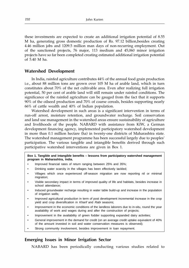
John Kurien232
these investments are expected to create an additional irrigation potential of 8.55M ha, generating gross domestic production of Rs. 97.12 billion,besides creating4.46 million jobs and 1209.5 million man days of non-recurring employment. Outof the sanctioned projects, 76 major, 113 medium and 45,060 minor irrigationprojects have so far been completed creating estimated additional irrigation potentialof 5.40 M ha.
Watershed Development
In India, rainfed agriculture contributes 44% of the annual food grain productioni.e., about 88 million tons are grown over 105 M ha of arable land, which in turnconstitutes about 70% of the net cultivable area. Even after realizing full irrigationpotential, 50 per cent of arable land will still remain under rainfed conditions. Thesignificance of the rainfed agriculture can be gauged from the fact that it supports90% of the oilseed production and 70% of coarse cereals, besides supporting nearly66% of cattle wealth and 40% of Indian population.
Watershed development in such areas is a significant intervention in terms ofrun-off arrest, moisture retention, and groundwater recharge. Soil conservationand land use management in the watershed areas ensure sustainability of agricultureand livelihoods of the people. NABARD with assistance from KfW, a Germandevelopment financing agency, implemented participatory watershed developmentin more than 0.1 million hectare (ha) in twenty-one districts of Maharashtra state.The watershed management programme has been successful largely due to peoples’participation. The various tangible and intangible benefits derived through suchparticipative watershed interventions are given in Box 1.
Box 1. Tangible and intangible benefits – lessons from participatory watershed managementprogram in Maharashtra, India.
• Improved financial rates of return ranging between 25% and 35%;
• Drinking water scarcity in the villages has been effectively tackled;
• Villages which once experienced off-season migration are now reporting nil or minimalmigration;
• Visible secondary impact in terms of improved quality of life and habitats, besides increase inschool attendance;
• Induced groundwater recharge resulting in water table build-up and increase in the populationof irrigation wells;
• Improved agricultural production in term of post development incremental increase in the cropyield and crop diversification in Kharif and Rabi seasons;
• Improvement in the economic conditions of the landless laborers due to in-situ, round the yearavailability of work and wages during and after the construction of projects;
• Improvement in the availability of green fodder supporting expanded dairy activities;
• General improvement in the demand for credit (on an average credit uptake equivalent of 40%of the amount invested in soil and water conservation measures is observed);
• Strong community involvement, besides improvement in loan repayment.
Emerging Issues in Minor Irrigation Sector
NABARD has been periodically conducting various studies related to

Institutional Credit Support for Minor Irrigation 233
investment, monitoring and evaluation, to identify opportunities and constraints inproviding credit for rural infrastructure projects. NABARD studies on minorirrigation projects have identified various constraints and reasons for lowerachievements of performance targets. Broadly, there are two main constraints ofproject financing: technical and financial and credit.
Technical constraints
Technical constraints in the minor irrigation projects are different for thesurface and groundwater irrigation projects. Surface water projects can be dividedinto two categories: (a) reservoir and tank irrigation projects, and, (b) cooperativeirrigation projects. In the case of reservoir and tank irrigation projects, there aretechnical constraints pertaining to silting, technical design and management, andlack of funds for maintaining reservoirs and tanks. Technical constraints in thecooperative lift irrigation projects are those related to faulty technical designs,flouting of technical specifications and guidelines, and non-availability of reliableelectricity supply resulting in either over-irrigation or under-irrigation of crops(Box 2).
Technical constraints in case of the groundwater irrigation projects relate towell failure and failure of borewell programs to reach eastern Indian states,conversion of safe blocks/watersheds into dark and over-exploited, non-enforcementby state groundwater department of guidelines pertaining to spacing andgroundwater assessment studies (Box 2).
Box 2. Technical constraints for surface irrigation projects
Reservoirs and tanks
• The supply channels of old tanks have been silted due to lack of proper operation andmaintenance (O&M) care; desilting work is an ineligible activity under institutional finance;
• The foreshore lands of tanks have been encroached upon by farmers for cultivation makingconstruction/repairs difficult;
• Distribution channels beyond sluice opening could not be completed in a number of tanks dueto fund constraints, land acquisition, and project affected people (PAP) issues, besides delayin obtaining Forest, Public Works Department, and Railways clearances;
• Non-execution of on-farm development works (up to 1.5 cusec outlets) more particularly inlarge minor irrigation tanks;
• Concurrent design changes leading to cost and time overruns;
• Effective submergence exceeding the limit with respect to Irrigable Command Area (ICA); and
• Inadequate annual provisions, in general, for O&M public grants leading to deterioration ofboth head works and distribution networks.
Cooperative lift irrigation
• Over designing of head works and distribution network to suit unauthorized/non permissibleuse of higher percentage of ICA for perennial crops like sugarcane than what is allowed bythe Water Lifting Permissions (WLPs), mostly in case of Sugar Factory (SF) sponsoredprojects;
• Flouting of WLPs issued by Irrigation Department (ID) for Kharif and Rabi seasons to growperennial crops, mostly sugarcane;
• Non observance of sanctioned technical norms/parameters; often project execution is half waythrough before applying for loan/refinance by Lift Irrigation (LI) Societies through primarybanks/branches;

John Kurien234
• Inadequate availability of water at the source point in river beds etc., due to unauthorizedtapping by similar structures in the upstream;
• Non availability of adequate and continuous electric supply voltage leading to under and/orover irrigation with associated problems including reduced crop yields or crop failures; and
• Other associated problems, e.g., leakages, pipe damages etc., affecting irrigation scheduleunder Cooperative Lift Irrigation Scheme (LIS) leading to post commissioning sickness/failureof LIS.
Groundwater projects
• Though program of ‘Free Boring’ was much accelerated in Uttar Pradesh state; it could not bepromoted to a desired level in other states like Bihar, Assam and West Bengal;
• Large scale well failure of both open wells and bore wells in hard rock areas due to absence/inadequate services from State Ground Water Departments (SGDs) for siting of well source,besides non availability of ground water worthy maps on user friendly scales (1:5000 or1:10,000) especially for use by program implementing banks/branches;
• Large number of blocks/mandals/watersheds coming under critical (dark) and overexploited(red) categories with depleted water levels where free flow of institutional credit is notavailable;
• Targets for construction of open wells and bore wells in hard rock areas fell short by nearly40 per cent due to drought conditions and declining water levels;
• Selection and installation of higher horse power (HP) electric and diesel pump sets than whatis required as per prevailing hydro geological conditions of the area and that too notconforming to IS:10804 of 1994 for Complete Pumping System (CPS) leading to overdraftconditions/ground water mining, besides higher consumption of both electric power and dieseloil;
• Non observance of spacing criteria under privately constructed wells due to absence of StateGround Water Legislation;
• State Ground Water Departments (SGDs) not carrying out ground water assessment as perGround Water Estimation Committee-1997 (GEC-1997) revised methodology/norms leading tonon-redressal of farmers’ grievances belonging to ‘Critical’ and ‘Overexploited’ blocks/mandals/watersheds declared with respect to earlier GEC-1984 methodology/norms. Similarly, there isa general apathy on the part of SGDs to conduct ground water assessment based on microwatershed analyses/studies to permit new well program in feasible pockets within such darkand critical blocks/mandals/watersheds; and
• Slow pace of energization in 10 eastern and north eastern states resulting in widening of gapsbetween potential created and utilized, besides undependable and erratic power supplycausing shortfalls in achievement of productivity targets.
Financial and Credit Constraints
Financial and credit are the second set of constraints. The main issues pertainto lack of resource availability with the central and the state government, poorperformance of irrigation schemes, unsatisfactory recovery of credit, and poor landrecords including fragmented land holdings, which restricts access to credit.Financial and credit constraints as identified by NABARD studies are listed inBox 3.

Institutional Credit Support for Minor Irrigation 235
Box 3. Financial constraints
• Inadequate central and state resource availability for new works. Most of these works areundertaken by state, Panchayati Raj Institutions (PRIs, village elected bodies), and, RuralDevelopment Department, where priorities clashed year after year including non-observanceof fiscal discipline particularly in Centrally Sponsored Schemes (CSS) implemented by thestate governments;
• Poor performance of lift irrigation schemes due to non repayment of bank loans and poor O&Mduring post construction stage by groups and cooperatives;
• Delay in loan appraisal due to cumbersome procedure and documentation insisted by banks;
• Unsatisfactory recovery position of banks leading to reduced lending eligibility. Besides, insome major states, SCARDBs have become weak due to mounting Non Performing Assets(NPAs) necessitating rehabilitation and adoption of reform packages;
• Delay in sanction and release of subsidy;
• High cost of micro irrigation systems;
• Diversification to other activities like farm mechanization, non-farm sector and other prioritysectors and contribution to Rural Infrastructure Development Fund instead of direct lending toindividuals or group of farmers;
• Sizable number of small and marginal farmers were not having access to credit because offragmented land holdings; and
• Inadequate land records.
Strategies for Boosting Minor Irrigation Institutional Investments
The Planning Commission has laid a major emphasis on accelerating the paceof minor irrigation development, especially groundwater schemes throughinstitutional investments during the Tenth FYP (2002-07). Accordingly, it is proposedto harness 14.66 M ha of minor irrigation potential (13.93 M ha ground water and0.73 M ha surface water) involving credit assistance of Rs. 3091.5 billion for newprograms. The programs would include: approximately 1.6 million dugwells, 2.6million shallow tube wells and bore wells, 7288 deep tubewells, 53 lakh agriculturepump sets, 7 lakh ha cooperative lift irrigation schemes, 0.86 million ha sprinklerirrigation units and 0.7 million drip irrigation units. Besides the new programme,there is a provision of Rs. 107.3 billion for replacement of old structures. Inaddition to these programs, the plan outlay has earmarked Rs. 442.7 billion forenergization program for agriculture pumpsets. The total financial assistanceenvisaged during the Tenth Plan is of the order of Rs. 3641.5billion. NABARD withthe active participation of various RFIs and other related agencies is to play acrucial role in steering various policies and programs with suitable modificationsso as to ensure purveying ground level credit disbursement at an accelerated paceto meet the country’s food demand targeted at 350 million tons by the end of thisdecade. The various initiatives related to credit planning and financial are givenbelow.
Credit Planning Initiatives
In order to harness the groundwater potential of the order of 13.93 M ha, it isproposed to annually create 2.786 M ha of additional irrigation potential throughout

John Kurien236
the Tenth FYP period through formulation of banking plans and area developmentprojects for dugwells, shallow tubewells and bore wells, medium deep tubewells,agriculture pumpsets (diesel and electric), and, underground pipe lines. These willbe covered under individual and group financing in ground water resource richstates and districts. Towards achieving this objective, adequate credit flow forminor irrigation sector has to be ensured.
Maintaining groundwater quality is critical for sustaining economic developmentand growth. In order to maintain ground water quality to sustain the projectedusage, a well-planned water resources management strategy for the country isneeded. The prevailing hydro-chemical regime has to be well established by abetter network and optimum frequency of water sampling points for baselineinformation, trend analysis and surveillance. Quality zonation maps includinggroundwater pollution levels of specific areas, the likely areas of pollution beyondrecoverable stage and the zones where the same can be controlled would have tobe demarcated. The priority of water use viz. drinking water, irrigation, industrialand cattle requirement - and extent of feasible extraction for each zone are to bedemarcated for further studies including chemical and microbial contamination ofgroundwater.
Government of India has formulated a credit linked subsidy program entitled“On Farm Water Management Scheme for Increasing Crop Production in Eastern andNortheastern States of India”. The objective of the scheme is to harness vastgroundwater potential available in ten eastern and northeastern states, forimplementation during 2001-02 and Tenth FYP period. Under the scheme, subsidyis provided to eligible farmers for shallow tubewells, dugwells, low lift points andpurchase of agriculture pumpsets in ten states: Assam, Arunachal Pradesh, Manipur,Mizoram, Bihar, Jharkhand, Orissa, Chattisgarh, Uttar Pradesh and West Bengal.An amount of Rs. 11.5 billion has been earmarked towards 30% subsidy for theyears 2001-02 and 2002-03. NABARD is the nodal agency for preparation ofbanking plans and release of subsidy as also monitoring the implementation of thescheme. In all 70,000 structures have been installed upto October 2004. Similarly,Million Shallow Tubewell Programme with 30 percent capital subsidy assistancehas also grounded 175,000 shallow tube wells in Bihar upto October 2004. Duringthe last year NABARD had worked with government and bankers in Bihar andcould influence banks to finance more than 50,000 minor irrigation structuresunder this scheme.
RIDF intervention has created an additional surface water irrigation potentialof 5 M ha between 1995-96 and 2003-04. The impact of this intervention has beenin terms of rejuvenation of groundwater in the downstream of the newly createdreservoir projects, activation of well fields in their canal command areas, besidesavailability of about 6 per cent committed share of their reservoir waters (amountingto creation of 0.26 M ha irrigation potential) for development through lift irrigationschemes. The exploitation of ground water in such areas has to be planned throughformulation of reservoir or command specific banking plans under institutionallending program. All these credit interventions would be possible only when therespective state governments annually allocate funds for operation and maintenanceof these newly created irrigation structures.

Institutional Credit Support for Minor Irrigation 237
Another initiative is to enhance credit support to micro irrigation systems withsimultaneous reduction in the quantum of subsidy in a phased manner, besideseffecting reduction in their unit costs by doing away with the sales tax and exciseduty and simultaneously initiating other suitable measures. The Task Force onMicro Irrigation (January 2004) has recommended to add about 2.0 M ha and 1.0M ha under drip and sprinkler irrigation systems during 2004-07, respectively. Thiswould require formulation and vigorous implementation of state wise and districtwise banking plans with emphasis on large scale adoption by states like HimachalPradesh, Jammu and Kashmir and northeastern states where the coverages underhorticulture crops have grown over the years but are lagging in adoption of microirrigation systems. Similarly, states like Punjab, Haryana and Uttar Pradesh whoare agriculturally advanced but slow in adoption of micro irrigation system; andstates facing frequent droughts e.g., Madhya Pradesh, Gujarat, Rajasthan andOrissa should be the focused areas for promotion and popularization of microirrigation. In states where adoption of micro irrigation is in advanced stage e.g.,Maharashtra, Tamil Nadu, Karnataka, Andhra Pradesh and Kerala where on anaverage 60,000 ha are annually brought under micro irrigation, efforts will have tobe intensified to enhance the coverage in various fruit and cash crops with strongsupport from the state government.
Yet another initiative is to encourage small lift irrigation schemes (up to 40 ha)for individuals or groups, medium lift irrigation schemes (up to 250 ha) incooperative sector and big lift irrigation schemes (up to 500 ha) on a very selectivebasis to sugar factory-sponsored schemes in cooperative sector. Program alsoencourages low lift point schemes (LLP) involving minimal engineering (3-5 HPelectric, diesel and petrol-start-kerosene driven pumpsets with 200 - 300 m length/4 kg per sq cm pressure class rigid PVC pipes) through formulation of areadevelopment plans exclusively for tribal and hilly areas based on identified surfacestream potential generally available upto February/March.
Promoting rainwater harvesting (RWH) through large scale financing of farmpond, weir, check dam schemes, especially in hard rock areas (central and southernpeninsular India) where groundwater is in a state of depleted conditions is anotherinitiative. Similar efforts also may have to be made in drought prone areasespecially in the plateau areas of Rajasthan, Madhya Pradesh, Gujarat and Orissa.A centrally sponsored water-harvesting scheme for SC/ST farmers has beenoperationalised by NABARD (since August 2004) with a credit linked capitalsubsidy of 50% to the extent of Rs.100 crore. The plan also encourages drainagedevelopment schemes (DDS) coupled with conjunctive use of surface water andground water especially in canal commands to avoid water logging in areas besetwith:• Shallow water table conditions (e.g., Punjab, Uttar Pradesh and parts of
Rajasthan and Maharashtra);• Surface run off stagnation (e.g., Andhra Pradesh, Haryana, Gujarat, Kerala,
Orissa, Punjab, Tamil Nadu, Uttar Pradesh and West Bengal); and• Saline/alkaline lands (e.g., Punjab, Haryana and parts of UttarPradesh).
This would require enhanced public sector funding towards the developmentand maintenance of main and intermediate drainage (M&ID) systems besides, allother on farm development (OFD) works under the Command Area Development

John Kurien238
Program (CADP) run by central/state governments. In addition, better integrationof the engineering, agriculture and extension functions in managing the system isneeded.
The government has also drawn plans to encourage schemes for constructionof new tanks, renovation and modernisation of existing tanks to restore lostpotentials, especially in the tribal and hilly districts of states like Madhya Pradesh,Maharashtra, Andhra Pradesh, Tamil Nadu, Orissa and Karnataka with people’sparticipation and NGOs. It will also involve ground water recharge (GWR) schemeswith the help of State Ground Water Departments or State Minor IrrigationDepartments in areas where water levels are persistently declining for sustainanceof wells facing partial or complete failures e.g., Maharashtra, Rajasthan, Saurashtrain Gujarat, Tamil Nadu, Karnataka and Andhra Pradesh. The plans also encouragelarge-scale reuse of treated water for irrigation under guidance from Central andState Pollution Control Boards. Besides, steps should be taken to protect groundwater resources from pollution.
Financial Initiatives
Financial initiatives as identified in the plan are as follows:• Continue existing refinance quantum of 90-100 per cent of the bank loan
depending upon the category of borrower, agency and region;• In view of the significance of minor irrigation as an important input for
accelerated growth in agriculture and the National Agriculture Policy todouble the food grains production by the end of this decade, NABARD hasconsiderably reduced the rate of interest on refinance for lending under thesector by various agencies. The present rates of interest are 5.50 per cent forloan size up to Rs. 50,000. For loans above Rs. 50,000, refinance will be at theinterest rate of 5.50 per cent for the northeastern region (including Sikkim andAndaman & Nicobar Islands) and 6.25 per cent for all other regions. Thisconcession is also available for minor irrigation disbursements made underother development schemes.
• Existing norms of drawal of re-finance for wells, pump sets, small lift irrigationschemes under Automatic Re-finance Farm Sector- Minor Irrigation (ARFS-MI)to continue in white or safe areas, whereas for larger investment outlays,formulation of area development projects and banking plans for prior sanctionby NABARD may have to be accelerated in resource rich ground water worthyareas both in hard rock and alluvial formations;
• In the case of drip and sprinkler schemes, where higher amount of subsidiesare involved, banks are advised to extend credit for total loan amount includingsubsidy after assessing the overall viability of the schemes and NABARDwould extend refinance on the basis of bank loans;
• Promoting innovative schemes with the help of state governments such as,creation of “Private Ground Water Markets” in water logged and salt affectedcommand areas. The schemes would finance projects in hard rock areas besetwith excessive use of ground water for growing cash crops such as sugarcane,and banana, for the benefit of adjoining non command areas; and

Institutional Credit Support for Minor Irrigation 239
• Promoting commercial agriculture and contract farming in identifiedgroundwater sanctuaries on pilot basis.
Emerging Issues
Some critical issues that are affecting the pace of irrigation development needfocussed attention:
Energization of Agriculture Pump Sets
Sluggish energization of agriculture pump sets is resulting in widening of gapbetween potential created and potential utilized. There are 1.3 million financedwells awaiting energisation (in terms of paid pending applications) for the last twoto five years by the State Electricity Boards (SEBs). During the Tenth FYP (2002-07)another 3.7 million electric pump sets would be required to be energised underinstitutional investment program. The SEBs therefore would be required to augmenttheir resources for system improvement of distribution network and also enhancingthe demand based distribution network. A related issue is the pricing of powersupplied to agriculture sector. Cost recovery would be an imperative that couldlead to accelerated energisation of agriculture pump sets.
Micro Irrigation
High cost of micro irrigation system i.e., drip and sprinkler units (average perha unit cost varying between Rs. 30,000/- for widely spaced crops and Rs. 60,000/- for closely spaced crops) are one of the major constraints in accelerating the paceof institutional investment. The Indian National Committee on Irrigation andDrainage (INCID) constituted for Drip Irrigation System under Ministry of WaterResources in 1994 and National Committee on Use of Plastics in Agriculture andHorticulture (NCPAH) constituted for Sprinkler Irrigation System under Ministryof Agriculture in 2001, have highlighted the issue of high cost of micro irrigationas the major constraints in large scale adoption. These issues are even prevalent instates, which are agriculturally advanced and have brought large areas underhorticulture crops (e.g., Punjab, Haryana, Himachal Pradesh). The committees havesuggested bringing down the cost through waiver of all types of taxes (sales taxand excise duties) both on raw materials and finished products of micro irrigationsystems. The Task Force on Micro Irrigation has also made similar suggestions onreduction of taxes and duties in 2004.
Groundwater Reassessment
Groundwater reassessment based on Groundwater Estimation Committee-1997methodology and norms have not been completed by many State Ground WaterDepartments (SGDs) affecting the financing of groundwater programs as largenumber of blocks/ mandals/ watersheds are turning into overexploited, critical anddark categories. The issue is that of safe and sustainable exploitation and use ofground water needs to be put in place. It is expected that revised groundwaterassessment will be completed by March 2005.

John Kurien240
People’s Participation in Community Irrigation Projects
RIDF financing has created 5.40 M ha of estimated irrigation potential throughcombination of projects till 2004. Effective turn over of these projects throughParticipatory Irrigation Management (PIM) or Water Users’ Associations (WUAs)is one of the conditions of sanction of projects to the state governments. In fact,most of the State Irrigation Departments (SIDs) and State Minor IrrigationDepartments (SMIDs) are slow on effectively turning over the projects to people.Participation is critical for maintaining the efficiency of structures and their optimaluse in an equitable manner.
Creation of Private Groundwater Markets
Creation of private groundwater markets on pilot basis, especially in the waterlogged areas affected by water intensive crops (e.g., Maharashtra, Karnataka,Gujarat, and Madhya Pradesh) could be developed as ‘Ground Water Sanctuaries’through willing entrepreneurs in private sector for sale of water to farmersbelonging to adjoining non-command areas. This would require state governmentsto take suitable legislative measures to throw open such groundwater sanctuaries,which are mutually beneficial to command and non-command farmers for privatesector participation.
Looking Ahead
Minor irrigation potential has a significant place in the country’s irrigatedagriculture. Its development is largely dependent upon institutional creditrequirements. Nearly 80% of the institutional credit disbursed under minor irrigationis on account of development of groundwater potential. In order to boost creditdisbursement more attention will have to be paid on systematic development ofgroundwater resources because of its inherent advantages.
From the preceding overview and analysis of the programs, it is apparent thatthe irrigation programs involve substantial amount of coordinated efforts fromdifferent stakeholders, not only in creation of irrigation works (wells and reservoirs),but also in undertaking periodic investigations and planning of both groundwaterregimen (hard rock and alluvial areas) and the river basins of the country.
Adoption of innovative approaches, such as, (a) water conservation and wateraugmentation through large scale micro irrigation practices, (b) construction of rainwater harvesting and groundwater recharge structures benefiting irrigation farmfields, (c) simultaneous watershed development measures in the dry land areas, (d)recycling of water for non-potable uses, would be required to enhance efficiency ofwater use. Diversification of agriculture to grow more cash and commercial cropson one hand, and increasing production and productivity levels through efficientuse of inputs including water on the other, would be vital for food security infuture.
In short, one cannot overemphasize the fact that water is a perennial but scarceresource. Efficiency and productivity of water use has to be the prime considerationin agriculture. While mechanisms for conservation and optimal use are availableand could be put in place, each time an irrigation resource is tapped, the question

Institutional Credit Support for Minor Irrigation 241
of what is the best possible use of this water needs to be answered. The sub-optimal use of water in some states has led to environmental degradation andadverse impact apart from reducing productivity of agriculture. An approach tooptimal use of water calls for both crop and land use planning.
A related issue pertains to pricing of irrigation water where the irrigationstructures and delivery mechanisms are owned by the states. Uneconomic pricinghas resulted in unwarranted and exaggerated use of water leading to adverseimpact. Appropriate pricing aimed at cost recovery would ensure that water isused for enhancing productivity and discourage unwarranted use. This would alsoensure that resources are generated for maintenance and repairs of the existingstructures. The Vaidhyanathan Committee’s recommendations in this regard havenot been implemented seriously by the states. It is high time that in the interest ofthe sustainability of agriculture the committee’s recommendations are taken up inright earnest. An additional issue is that of rainfed lands which constitute themajority of the cultivable land in the country. Dr. Swaminathan had suggested thatthere should be a goal of bringing at least one million ha each year underwatershed development program. While the task seems immense, a missionapproach could deliver the results required which are critical for the future of largenumber of resource poor farmers engaged in agriculture in such regions. Finally,we are all aware that water is not a mere input in agriculture; it is a source oflivelihood that requires systematic planning and careful use.
It is important to recognize that in water sector, there is no single solutionuniformly applicable to all the agro-climatic regions and sub-regions of the country.Each approach of treatment and development is valid in its own right and has tobe given equal priority along with other strategies and solutions. Coordination andeffective participation by various stakeholders for resource care and sustainabledevelopment whether institutionally, privately or through public is very essential.It is in this backdrop that NABARD, the state water resources departments (bothground water and surface water), banks and other concerned departments andresearch institutions must join hands to coordinate their efforts in boosting rationalexploitation of irrigation water potential to enable the country to achieve the goalof reaching a food production level of 400 - 450 million tons by 2025.

Understanding and Managing the Water–EnergyNexus: Moving Beyond the Energy Debate
Shirish Sinha, Bharat R. Sharma and Christopher A. ScottInternational Water Management Institute (IWMI),
South Asia Office, New Delhi, India
Abstract
Energy and water are key instruments for agricultural production and their interlinkagespose significant management challenges. Lack of appropriate energy policy and policy todeal with management of groundwater has not only contributed to over-exploitation ofgroundwater; it has also resulted into a nexus. Perverse incentives provided as part of theenergy policies have led to economic inefficiency in the performance of the electricityutilities, playing havoc with the energy economy of the country and viability of the energysector. Analyzing the growth in use of groundwater and energy for pumping coincides withIndia’s overall development policy of attaining food security. However, much of the debateon water- energy nexus as an indirect approach for groundwater management has focusedon the energy side of the nexus, ignoring the role of agriculture policy, especially thosedealing with gaps in market linkages for agricultural products and role of minimumsupport price, which have greater influence on farmer’s choice of cropping pattern andhence excessive groundwater use. Policies governing agriculture and energy are apparentlydictated more by political populism rather than sound management strategies for sustainableresources development. Combined effect of these policies has resulted in the hydrologicalunsustainable over-exploitation of groundwater. In this paper, the authors argue that thereis need to further the debate on water-energy nexus beyond the realms of those focusedprimarily on energy policies.
Introduction
Despite a decade and half of economic reforms in India, agriculture remainsthe backbone of the economy and a direct and indirect source of livelihood forIndia’s vast rural population. The recent estimates show that the agriculture sectoraccounts for 22% of the Gross Domestic Product (GDP), and provides livelihoodsto 58% of the population (584 million people, GoI, 2004). In fact, energy (electricity)and water (irrigation) have emerged as key determinants of economic growth andsocial development in the rural areas in India.
Groundwater has become the mainstay of irrigated agriculture in India. Energy,especially electricity, has contributed significantly to the development and

Understanding and Managing the Water–Energy Nexus 243
exploitation of groundwater resources, improving productivity and providinglivelihood and food security (Shah et al., 2003). While energy and water havestrengthened economic opportunities in rural areas and ensured food security,these are also threatening this very livelihood option. Groundwater resources inIndia are largely unmanaged, resulting in high possibility for its over-exploitation,thus threatening people’s livelihoods and endangered drinking water supplies.This is further aided by energy policies and perverse incentives created by energysubsidies, inefficient electricity distribution system involving unreliable, poor qualityand restricted hours of supply. Lack of appropriate energy policy has not onlyindirectly contributed to overexploitation of groundwater, creating a water-energynexus, the energy policies have also, resulted in economic inefficiency of electricityutilities (State Electricity Boards), playing havoc with the energy economy of thecountry and seriously affecting the viability and reform process of the energysector.
Much of the debate on managing the water – energy nexus has focused onintervening on the energy side of the nexus as an indirect tool for arresting thedepletion of groundwater, which is addressing only half of the problem (Shah et.al., 2003; Sharma et. al., 2005). The indirect approach in energy policy has atechnocratic bias, rather than the appreciation of the other side of the problem, theassociated policy issues and political nature of the problem. Energy policyintervention, especially those policy measures initiated since electricity sectorreforms have focused on either economic – raising electricity tariff for agricultureusers – and/or technical – installing meters and doing demand side managementto improve the pump set efficiency. The standard electricity reforms prescriptionshave witnessed little buy-in from the farmers, as well as politicians. While individualfarmers have opposed metering; collective action, and lobbying by farmer’s groupshave been effective in blocking tariff increase and payment of arrears. Thesecollective actions of farmers have also found support from the political groups,who have used the means of waiver of dues and subsidized to free power as aninstrument for rural development and to win farmer’s vote.
Energy and water are key instruments for agricultural production. Irrespectiveof the changes in the energy policy, the demand for groundwater depends uponwhat farmers grow, which in turn is influenced by the support price policy,agriculture (food security) policy, and, market linkages. Government policies in theagriculture sector are multi-faceted and inadvertently encourage the production ofwater intensive crops over more water efficient commodities. Indian agriculturesuffers from a mismatch between food crops and cash crops. Domestic productionof pulses and oilseeds are still much below the domestic requirements. A distinctbias in agriculture price support policies in favor of rice and wheat has distortedcropping pattern and utilization of different inputs. Besides this, market for farmproduces continues to be dominated by heavy procurement interventions by thegovernment agencies.
Analyzing the growth in use of groundwater and energy for pumping coincideswith India’s overall development policy of attaining food security through GreenRevolution technologies. The nexus that is visible today is due to the fact thesepolicies did not change with time. That brings to another external factor – political- affecting the nexus: the rise of farmer’s movement coupled with political populism

Shirish Sinha, Bharat R. Sharma and Christopher A. Scott244
in the late seventies and early eighties. The farmer’s movement in southern statesof Andhra Pradesh and Tamil Nadu brought the political intervention of freepower. Almost parallel movement of farm lobby in northern and western Indiabrought more subsidies in the agriculture sector in form of inputs and minimumsupport price for food crop procurement. Combined impact of these policies hasaffected the water and energy sectors. Breaking the nexus would require not justpolicy changes at the level of farm input subsidies, but also a realistic and strategicshift from minimum support price policy, and developing alternate productmarkets essential for crop diversification.
Water – Energy Nexus: Moving Beyond the Energy Debate
Water – energy nexus in India is a result of policy issues such as those dealingwith groundwater, agriculture, and energy. Rapid development of high intensity ofpump sets of smaller capacities scattered throughout the landscape makes water –energy nexus peculiar. Yet, another feature of the nexus is the existence ofgroundwater markets, where especially the small and marginal farmers dependupon the pump owners to buy water. Groundwater resources are largely unmanagedand the policies needed to deal with the problem are not yet in place. Agriculturalpolicies, especially the procurement policies are such that they have encouragedfarmers to continue growing more water intensive crops (rice, sugarcane etc.).Energy policies and economic incentives (or disincentives) for use of electricity forgroundwater extraction, has resulted in almost zero incremental cost for thefarmers. At the same time, inefficient electricity distribution system involvingrestricted hours of supply, with unreliable and poor quality has resulted in longhours of pumping by the electric pump owners.
The existing discussion on water energy nexus, attempts to capture a simplelinear causal relationship between water and energy sector, as shown by thebottom part of the triangle in Figure 1. The causal effect for the energy-water nexusis not just due to inadequate energy policy or groundwater policy or the absenceof any linkage between the two sector issues. Uncertainty of monsoon and existenceof groundwater markets add further stress to the groundwater resources. This is avicious cycle from the groundwater sector perspective. Energy sector policiesprovide electricity at a very low cost for agriculture and contribute to the socio-economic development of the rural areas. Due to shortages in electricity generation,and almost negligible return from supplying electricity to farmers (low/ nil tariff,non-payment), the utilities restrict the supply hours and provide it during off-peakhours. Lack of investments in strengthening the supply infrastructure by theutilities often results in frequent breakdowns and burnouts. Dispersed nature ofelectricity connections, means very little monitoring, and allows pilferages. Thisresults in a vicious cycle, which the farmers mitigate by pumping for all the hourssupply of electricity is available and in the process affecting the groundwaterresources. These two vicious cycles are considered as the cause of the nexus. Thenexus is complicated further by policies related to those of the agriculture andtrade and procurement support policies, which influence the choice of cropsgrown.

Understanding and Managing the Water–Energy Nexus 245
Broadly, there are two approaches to arrest depletion of groundwater – directand indirect. The direct approach for groundwater management has largely failed,as access to groundwater is through right of capture and the number of users issimply too large for effecting any regulations. In fact, despite being a commonresource, inability to manage groundwater is a classical failure of common propertyresource management. In the absence of any effective legislation for groundwatermanagement, indirect approach through energy policy intervention has beenconsidered as an alternate option.
Energy policy as an indirect tool for groundwater management has twinadvantages: one, it can be effective in arresting groundwater overexploitation, and,two, it will also lead to economic viability of the energy sector. The energy sectorpolicies have focused either on technical solution of metering and demand sidemanagement, or through economic instruments of electricity tariff revisions. Thepolicy prescriptions have emerged since the on-set of energy sector reforms, whichviews electricity supply to agriculture and poor recoveries as key factor for poorperformance of electricity utilities in India. However, energy policy interventionshave limitations, and given the standard prescription, they are more likely tobenefit electricity utilities, than either the farmers or arresting groundwater depletion.It is therefore in context of these issues, that these energy policy interventions haveseen little buy-in from the farmers (Dubash, 2005).
Given the limitation of the changes in energy policy, there is a need to look atthe problem from a holistic perspective. Energy and groundwater are inputs to
Figure 1. Water - energy nexus – moving beyond the energy debate

Shirish Sinha, Bharat R. Sharma and Christopher A. Scott246
support agriculture development and improving farm productivity. In fact, choiceof crops by farmers are not determined alone by the quality and economic cost ofdifferent inputs such as electricity, but, the economic returns, market demand forcommodities, and market linkages are dominant factors. The debate on water –energy nexus would remain incomplete and lead to inconclusive solutions, withoutlooking at the role of agriculture sector policies.
Adding the agriculture component to the nexus as shown in Fig.1 modifies thewater-energy nexus. The schematic diagram shows that there is a vicious cycleoperating within-water, energy, and agriculture sectors - creating a nexus. In theabsence of effective groundwater legislation to control over-exploitation ofgroundwater, and under the favorable condition of agriculture policy, whichemphasizes on production of food grains through procurement support, there isexcessive dependence on water intensive crops leading to depleting groundwaterlevels and lack of crop diversification. Perverse incentives provided as part of theenergy policy coupled with poor quality and un-reliable electricity supply hasresulted in long hours of pumping and leading to wastage of both energy as wellas groundwater. Implementation of policies in the agriculture and energy sectors,have resulted in misguided targeting, as benefits of the agriculture subsidies arecaptured by agriculturally prosperous states and benefits of electricity subsidy aremostly retained by rich farmers, instead of poor states and small/marginal farmers.
Although Figure 1 shows the internal vicious cycles between agriculture, waterand energy sectors, it does not show the coping mechanisms that farmers adopt inlight of inefficient power supply. Rapid growth in groundwater wells is largelybecause of unreliable power supply. When power fails, the additional wells wouldhave pumped enough to meet the requirements. When pump fails, the additionalwells would be used to fill in. Surveys in Andhra Pradesh and Haryana alsoshowed that most of the large and medium farmers had more than two wells perfarmer. These are the ones that have the capacity to invest in additional wells andbenefit from energy subsidies. The coping mechanisms adopted by the farmers addto increased pressures on both energy and water (Sharma et.al, 2005).
Groundwater
Groundwater irrigation developed towards early 1960s in India, and expandedrapidly after 1969 with the expansion of grid electricity to rural areas. At present,groundwater supplies water to 70% of the irrigated area (Shah et al., 2003). Overthe last two decades, 84% of the total addition to the net irrigated area came fromgroundwater, and only 16% from canals (Figure 2). As it can be seen from theFigure 2, the net irrigated area by groundwater is about twice the area irrigatedby the canals.
The current dependence on groundwater irrigation started as a viable alternateoption largely due to certain critical changes that took place in the Indian agricultureand irrigation sectors. Surface irrigation sources such as canals and tanks requiredmassive public investment and complex institutional set-up. Over the years publicinvestments in irrigation infrastructure has declined and simultaneously the surfaceirrigation source suffer from poor maintenance leading to deterioration in qualityand inadequacy of water supplies.

Understanding and Managing the Water–Energy Nexus 247
With India’s demand for food security becoming the primary objective ofagriculture development, the demand for groundwater irrigation increased.Groundwater irrigation was also considered as a viable technical option to reducewater logging and salinity in certain areas of river basins. For the farmers,groundwater provided flexible option of applying right quantities of water whenneeded. Groundwater irrigation received further fillip due to increased availabilityof irrigation pump sets at affordable prices and ease in access to subsidized credit.
Groundwater exploitation in India has contributed to irrigation, povertyreduction, and rural development benefits. However, its utilization pattern andheavy dependence have raised sustainability concerns. Groundwater estimatesindicate that more than 9% of the administrative blocks/watersheds/talukas areover-exploited, and nearly 5% of them are in critical stage (Romani, 2005). Theseestimates are based on assessment conducted around 1999. The situation hasaggravated since then. For example in Karnataka, the 1999 estimates identified aDoddaballapura taluka as “safe” and only parts of the taluka were semi-critical(GoK, 2004). However, the recent assessment by the state government departmentshows that the entire taluka has now been classified as “critical”(Venugopal, 2005).The change in the availability of groundwater in this area has been largely due toincrease in number of bore wells, increase in depth of bore wells, and poormaintenance of tanks. Anecdotal evidence from the area also suggests that the wellfailure rate is extremely high, and existing bore wells have started to dry.
Agriculture
Agriculture has been the mainstay of the economy and its growth is pre-requisite for economic and social development of the Indian economy. As notedearlier, agriculture sector accounts for 22% of the GDP, but at the same time, itsupports livelihoods of 58% of the population. The Xth Five Year Plan (FYP) hastargeted an average annual growth rate of the agriculture sector at 4 per cent
Figure 2. Source-wise irrigation development in India

Shirish Sinha, Bharat R. Sharma and Christopher A. Scott248
(Planning Commission, 2002b). However, monsoon plays a critical role in thegrowth rate of the sector. Severe drought in 2002 resulted in negative (-7.0 per cent)growth rate, as deficient rainfall significantly affects Kharif (rainy season) foodgrain production (GoI, 2005a).
Post independence growth of agriculture owes much to the conscious andproactive government policy to promote agricultural productivity and overalldevelopment. These could be largely ascribed to measures such as public investmentsin irrigation, rural electrification, research and development and transfer ofknowledge to field to improve crop productivity, development of credit networksand extension services, guaranteed support prices for outputs and subsidizedinputs. Annual growth rate of 2.7% for all crops achieved during 1949-1995 wasconsiderably higher than insignificant growth of 0.3% per annum registered duringthe first half of the century. Accordingly, food grain production has grown from50.8 million tonnes in 1950-51 to about 212 million tonnes in 2001-02.
However, in striving to achieve food security, the basic principle of rationalpricing and sustainable management of natural resources were neglected in India.The magnitude of un-recovered costs on subsidized inputs has been rising at amuch faster rate than public investment in the sector. Apart from rising inputsubsidies, subsidy provided by the government as output subsidy in the form offood subsidy has also been increasing and contributing to the rising subsidy bill forthe government. Food subsidy in India comprises of subsidies to farmers throughsupport price and purchase operation of the Food Corporation of India (FCI),consumer subsidies through the public distribution system, and subsidies to FCI tocover all its costs. Food subsidies are mainly on account of food grains - paddy andwheat - both being water intensive crops and rely on groundwater.
Food subsidy, especially the minimum support price (MSP) has asserted inimproving food security through affordable prices for the consumers and incentivesto the farmers in form of assured market and thus keep food grains production ata comfortable level. However, these policy measures have also created a lock-insituation, where food grains production dominates and domestic production ofother cereal crops and oil seeds have suffered because of food security. Analyzingthe food subsidy bills in India for the period between 1990-91 and 2003-04, showsa ten times increase in the food subsidy (Table 1). In 1990-91, the food subsidy wasRs 245 billion (1 USD ~ INR 45) and it increased to Rs. 2580 billion in 2003-04. Infact, after 1994-95, the annual growth in the food subsidy bill has registered agrowth, due to increase in MSP and open-ended procurement. Food subsidy isfurther increased by the low off-take of food grains for distribution and build-upstocks.
Higher food subsidy bill in the last five years has been on the account of open-ended procurement policy with no upper bounds on procurement levels. Underthis procurement scheme, the government buys whatever is offered to it at the‘going’ MSP. Analyzing the food subsidies in India indicates that a large part of therecent problems arise from the relatively high MSPs (Table 2). Not only the MSPis higher, it is also at levels higher than the price recommended by the Commissionon Agricultural Costs and Prices (CACP). The declared MSP has had severalnegative fallouts. Significant from the water-energy nexus perspective, is the factthat the exclusive attention to wheat and rice has distorted the cropping pattern of

Understanding and Managing the Water–Energy Nexus 249
farmers in the favor of these two food grains alone. The higher water intensity ofthese two crops in turn has had adverse environmental impacts.
The other negative impact of the MSP is the inequitable distribution ofsubsidies due to concentration of procurement in just two food grains and selectedstates. In 2003-04, nearly 95% of the wheat was procured from Punjab, Haryanaand part of Uttar Pradesh. Similarly, nearly half of the paddy procurement wasfrom the states of Haryana and Punjab, followed by Andhra Pradesh andChattisgarh. Not only farmers in these selected states draw the benefits of the
Table 1. Growth of food subsidies in India
Year Food subsidy Annual growth(Rs.,billion) (%)
1990/91 245.0 —
1991/92 285.0 16.33
1992/93 280.0 -1.75
1993/94 553.7 97.75
1994/95 510.0 -7.89
1995/96 537.7 5.43
1996/97 606.6 12.81
1997/98 790.0 30.23
1998/99 910.0 15.19
1999/2000 943.4 3.67
2000/01 1206.0 27.84
2001/02 1749.9 45.10
2002/03 2417.6 38.16
2003/04 2580.0 6.72
Source: (Ministry of Finance, 2004).
Table 2. Minimum support price(MSP, Rs. per 100 kg) of wheat and paddy
Crop Year Paddy (Common) Wheat
MSP % Change MSP % Change
1990-91 205 225
1995-96 360 5.9 380 5.6
1996-97 380 5.6 475 25.0
1997-98 415 9.2 510 7.4
1998-99 440 6.0 550 7.8
1999-00 490 11.4 580 5.5
2000-01 510 4.1 610 5.2
2001-02 530 3.9 620 1.6
2002-03 530 — 620 —
2003-04 550 3.8 630 1.6
2004-05 560 1.8 640 1.6
Source: (Ministry of Finance, 2004; GoI, 2005b).

Shirish Sinha, Bharat R. Sharma and Christopher A. Scott250
subsidies, within these states the large farmers, leaving out small and marginalfarmers, mostly enjoy these benefits. Study in Andhra Pradesh has shown thatfarmers, notably small and marginal, face several hurdles in realizing the MSPsoffered by the government.
In summary, food subsidies have not only resulted in being mis-directed andleading to wastage of subsidies, they are responsible for excessive dependence ontwo food grains – paddy and wheat. This has not only affected the croppingpattern, it has also resulted in over-exploitation of groundwater.
The Energy Angle
Improving access to electricity for social and economic development in therural areas has been the mainstay of the energy policy in India. Energisation ofirrigation pump sets was integral to the rural electrification program with theobjective of creating economic opportunities in the agriculture sector along withcreating agro-processing units. At the time of independence, there wereapproximately 6500 irrigation pump sets. In the interim period of 1966-69, betweenthe IVth and the Vth FYPs, about one million pump sets were installed. However,after 1969, there has been an exponential growth in number of energized pump sets(Figure 3). As it can be seen from Figure 3, after 1969, the number of energizedpump sets has substantially increased during each plan period. This was possibledue to expansion of grid electricity in the rural areas, mostly on the back of multi-purpose irrigation projects, easy availability of pump sets and affordable drillingservices in the market, access to subsidized credit, for realizing potential ofgroundwater for irrigation. The trigger point was the consecutive years of droughtbetween 1966-68, which changed the face of Indian agriculture, irrigation, and roleof electricity in supporting irrigation and agriculture for attaining food security.
Figure 3. Progress in pump set energization in India 1947-2003 (Source: Sinha (2005)

Understanding and Managing the Water–Energy Nexus 251
As it can be seen from Figure 3, 70% of the groundwater potential has alreadybeen utilized. Groundwater estimates based on the available resources, indicatethat approximately 19 million pump sets can be installed in India. The decline inpace of pump set energization in the last two Five Year Plans is largely due tosaturation in most of the agriculture prosperous states, denial of new pump-setconnections and subsidized credit in the ‘over-exploited’ or ‘critical’ administrativeunits. In the states such as those in the eastern India, where high potential forgroundwater exploitation is possible, then these states are affected by low densityof rural electricity grid, poor availability of electricity supply, high incidence ofpoverty making access to individual ownership of pump set difficult, and theseproblems are further complicated by bureaucratic inefficiencies in these states.
The widespread increase in utilization of groundwater from 1970s onwardswas supported by incentives from the state electricity utilities through provision ofsubsidized tariff. While 1970s were the peak period for rapid increase in groundwaterirrigation, two policy interventions in the energy sector during this period, resultedin their over-exploitation in coming years. One intervention was in the form ofchange in the billing of agriculture consumers. Agriculture consumers were billedbased on energy used as per the energy meter. The billing was changed to load-based tariff (per horsepower [hp]) of the installed pump set capacity. Utilities feltthat the change was necessitated to reduce the transaction cost involved in meterreading and bill distribution to the thousands of scattered pump set users in therural areas. The negative implication of such a move resulted in under-reporting ofpump set load used by the farmers, contributing to commercial losses for theelectricity utilities.
Second policy intervention came from the government as part of larger politicalpopulism. Under pressure from rising farmer’s movements in parts of southernIndian states, followed by similar movements in northern India, state governmentsintroduced highly subsidized tariff and subsequently many states offered freeelectricity for the agriculture sector. Free electricity was introduced in AndhraPradesh towards the end of 1970s and was followed by Tamil Nadu and Punjab.This political populism soon spread to other neighboring states.
The combined effect of these policy intervention resulted in poor performanceof state electricity utilities, which over a period due to under-recoveries, becamefinancially insolvent. While the agriculture sector share in total electricity salesincreased, revenue realization remained extremely low. As it can be seen fromFigure 4, during the period of 1994-95 and 2001-02, total sales of electricity to theagriculture sector was more than 30%, but revenue realization was less than 5%(Planning Commission, 2002a). The high commercial losses meant that theinvestment by the utilities in electricity distribution infrastructure declined over theyears. As a result quality of power supply was characterized by low voltage andfrequent outages and reliability of supply further deteriorated. At the same timepower supply was scheduled during off-peak demands, therefore resulting insupply during night time. Farmers coping mechanism to counter low voltagepower supply and frequent interruption during scheduled supply was to use phasesplitters to run pump sets from single-phase power supply. To counter thenighttime power supply and unscheduled supply, farmers adopted auto-switch torun pump sets. Implication of such pump set utilization pattern negatively affectedgroundwater utilization.

Shirish Sinha, Bharat R. Sharma and Christopher A. Scott252
Not only these policy interventions created unfavorable utilization ofgroundwater, they also contributed towards rising subsidy bills. Cumulativesubsidies provided by all states for agricultural consumers increased from Rs. 593.8billion in 1991-92, when energy sector reforms were started, to Rs. 2380.6 billion in2004-05 (Table 3). This increase in subsidies has been despite the adoption ofminimum tariff of Rs. 0.50 per unit under the common minimum plan for powersector reforms. The rising subsidy bills have largely been on the account of politicalinterference in pricing of electricity for agricultural consumers, and it has been inthe form of either free electricity or waiver of electricity dues.
Table 3. Growth of electricity subsidies for agricultural consumers in India
Year Subsidy Annual growth(Rs. billion) (%)
1991-92 593.8
1992-93 733.5 23.53
1993-94 896.6 22.24
1994-95 1094.1 22.03
1995-96 1360.6 24.36
1996-97 1558.6 14.55
1997-98 1902.1 22.04
1998-99 2247.3 18.15
1999-00 2417.8 7.59
2000-01 2407.4 -0.43
2001-02 2401.3 -0.25
2002-03 2184.5 -9.03
2003-04 2334.6 6.87
2004-05 2380.6 1.97
2005-06 2537.7 6.60
Source: (GoI, 2002; Planning Commission, 2002a; GoI, 2004; GoI, 2005a).
Figure 4. Electricity for agriculture consumers in India – agriculture share (%), revenue realization (%)and changes in average agriculture tariff 1994/95-2001/02 (Source: Planning Commission 2002(a)

Understanding and Managing the Water–Energy Nexus 253
Political populism in the energy sector can be classified into two categories –one, pertains to provision of free electricity, a policy which was followed by statessuch as Punjab, Madhya Pradesh and Tamil Nadu and were reintroduced by statessuch as Andhra Pradesh and Tamil Nadu after 2004 state assembly elections.Maharashtra also provided free electricity for short period in wake of 2004 stateassembly elections and withdrew the scheme within six months of returning topower. Punjab, which gave free power in 2002, also withdrew in six months, butrecently in 2005, the state government has reintroduced free power in view offorthcoming state election. Second, measure is in form of waiver of electricity dues,a policy that has been continuously followed by many states and in recent years,states such as Madhya Pradesh, Karnataka, and Maharashtra in 2004 gave waiverof electricity dues just before state assembly elections. Haryana offered waiver ofarrears with a rider that with regular payment of 10 bi-monthly bills, arrears shallbe reduced by 10% with each payment. While waiver of arrears is not same asproviding free power, but instead is an interim measure of providing relief tofarmers. However, this has resulted in creating a non-payment behavioral patternby the farmers, who expect another round of waiver to come in future. Forexample, empirical evidence from Karnataka shows that farmers have stoppedpaying electricity bills after a waiver was announced before state assembly electionsin 2004.
Discussion
Analysing the scenarios of groundwater, agriculture, and energy sectors andthe implications of the policies on groundwater over-exploitation, policy andprogram intervention in the water sector needs to be supported by appropriatepolicies of the energy and agriculture sector. Direct management of groundwatersuffers largely due to lack of legislative instruments including low opportunitiesfor effective implementation of legislative controls (even in states where suchlegislations are existing), development of groundwater through right of capture,political sensitivity associated with its use for agriculture, food security andlivelihoods, and the fact that much of the groundwater development actually takesplace through private capital investments of the farmers. Even in states such asAndhra Pradesh, which enacted an Andhra Pradesh Water, Land, Trees Act, hasrun into institutional barriers and lack of teeth to restrict over-exploitation ofgroundwater (Narayana et al., 2005). Given this broader context of the groundwater,specific intervention can be focused on recharging the aquifers by managing run-off water from surface irrigation sources and rainfall. These interventions canprovide positive benefits, however, the rate of recharge varies and rate of extractionis influenced by crop choice and density of pump sets. Energy sector policies andagriculture policies have to support groundwater interventions. Anecdotal evidencefrom watershed management in Madhya Pradesh showed that once the three-yearrestriction on digging new bore wells was removed, irrigation pump setsmushroomed. Even under other watershed management programs, benefits ofgroundwater recharge efforts by the community upstream were captured by fewinfluential farmers downstream (Sharma et al., 2005).

Shirish Sinha, Bharat R. Sharma and Christopher A. Scott254
Energy Options
The current approach in the energy sector has focused on technical andfinancial fixes to the problems. However, energy policies are concerned until themeter side of the pump set. Metering is the most debated aspect, as energy sectorreforms proponents have argued that metering may not only reduce distributionand commercial losses for the utilities, but also induce efficient pumping andadoption of efficient pump sets by the farmers (Padmanabhan, 2001). The latter isassuming that farmer’s would be rational in their approach, and is not likely totake place unless an overall change is brought in the distribution of electricitysupply – quality, reliability, and time of supply (Reddy, 2000). Benefits of meteringwill be largely drawn by the electricity utilities, as it will improve accountability inthe sector, however, there is little buy-in from the farmers. Farmers look atmetering with distrust, as they expect that the otherwise flat tariff would increasein near future. Farmer’s opposition to metering also stems from the fact thatmetering would not allow them to pilfer by under reporting pump capacity.
Pricing of electricity closer to the cost of supply is another common prescription.Appropriate tariff is the most prudent option, however, electricity pricing for theagriculture sector follows political logic rather than sound economic principles.The common quote from an influential politician states that “ Pricing is not just amatter of people’s willingness to pay. It’s also a matter of politicians’ willingnessto charge”. At the same time, there are other sets of arguments related to pricingof electricity. Electricity supplies to farmers are in fact, off-peak and highly un-reliable, and thus does not cost the electricity utilities even the average cost ofsupply (Bhatia, 2005). At a larger policy level, since electricity pricing are linked topolitical outcomes, tariff rationalization is not likely to be achieved in many states.The problem is not such much of appropriate tariff, but the inability of the utilitiesto do collection. In the recent past, there has been lot of outcry related to provisionof free power. Free power sop runs contrary to the Electricity Act, 2003, whichprescribes a gradual phasing out of cross-subsidies. However, there are severalstates which give waiver of electricity dues, and in the absence of revenuecollection, electricity supply virtually becomes free. For example in Karnataka,where the utilities are not collecting any revenue from agricultural consumers, andat the same time the farmer are unwilling to pay and hoping for waiver of dues.
In this context, three options of energy side need to be explored further:• The first is the analysis of the scheme introduced by the State Government in
Haryana in 2005. Instead of giving a one-time waiver of electricity dues, thegovernment introduced an “Arrear Waiver Scheme.” As per the scheme, 10%of the arrear would be written off with the continuous payment of each of thenext ten electricity bills on a two-month cycle. If the farmers miss any of thecurrent payments, the scheme will start all over again. Preliminary observationsindicate that scheme has been quite successful as more than 90% of the farmersin Bhiwani and Jind districts – districts with highest incidences of default -have utilized the scheme.
• The second option pertains to adopting a different system for setting electricitytariff for groundwater utilization. At present, the State Electricity RegulatoryCommissions (SERCs) or State Electricity Boards (SEBs) sets tariff (per HP or

Understanding and Managing the Water–Energy Nexus 255
per unit) for different consumers across the state and based on pooled averagecost of supply. There is no differentiation in the tariff for different regions.Instead of this pooled average cost of supply, electricity tariff could be fixedbased on the groundwater classification as over-exploited, critical and safe.This will not only bring two sectors to work together, it will also provide someaccountability towards how groundwater has to be utilized. As part of thedistribution reforms in the electricity sector, multiple distribution utilitieseither have been formed or are in the process, which makes it possible to havegroundwater classification based electricity tariff. Regions that are classified asover-exploited can have higher electricity tariff (flat or metered), when comparedto regions, which are classified as safe. High electricity tariff rate would act asa deterrent for farmers to grow water intensive crops in over-exploited andcritical areas. In other terms, higher tariff for the over-exploited and criticalareas would be equivalent to an environmental cess, which the farmers in suchregions would have to pay to utilize groundwater. However, implementingsuch tariff system requires maturity to think out of the hat by the SERCs/SEBs,which set the tariff. This will also require a political vision to introduce suchdifferential tariff system.
• The third option relates to matching energy supply with the irrigation needs ofthe farmers. Crop water needs are generally not linear in nature but follow apattern closely dictated by crop growth patterns with high water/ energyrequirements during planting and high vegetative growth (Sharma et. al, 2005).At the core of the nexus, is the mismatch between irrigation needs and energyavailability. Power supply is good and reliable, when the irrigation needs ofthe farmers are low, and of inferior quality and in short supply when theirrigation needs are higher. When the irrigation needs are higher and powersupply is unreliable, farmers are frustrated and opt for options such asexcessive pumping of groundwater, power pilferage and default. These pumpingpatterns not only stress the electricity distribution infrastructure, but alsoincrease commercial losses for the utilities. Matching energy supply withirrigation needs of the farmers would result in a win-win scenario, as farmerswould be happy and the volume of subsidy would be controlled. However,this would require significant work at the electricity feeder level by developinglocal intelligence mechanisms. Shah et al., (2003) also suggested ‘intelligentpower supply’ in which energy supply pattern is matched with crop waterneeds.
Agriculture Options
While managing input subsidies such as those provided by electricity canresult in, to some extent, in efficient utilization of groundwater, but a more directapproach would come through policy interventions from the agriculture sector.There are two inter-linked policy issues, which can have direct bearing ongroundwater utilization as well as equitable distribution of food and energysubsidies. First, policy issue deals with the restructuring of the MSP mostlytargeted to paddy and wheat. Second, policy issue is the procurement policy for
Shirish Sinha, Bharat R. Sharma and Christopher A. Scott256
the food grains, which is inter-linked to MSP. Both these policy options have to bereviewed and implemented concurrently.• As argued under the agriculture sector, MSP associated with paddy and wheat
accounts for bulk of the food subsidy bill. In the last five years, the MSP pricesfor paddy and wheat have increased marginally, but open-ended procurementnorms distort subsidy allocation, as well as encouraging paddy and wheatcultivation in states, which are increasingly becoming water scarce regions. Thegovernment needs to intervene either by freezing the MSP or by introducinga time bound phase out of the MSP. This is likely to trigger cropping patternshift by the farmers, if the economic returns are no longer attractive. From apolicy perspective, this option again has political implications. MSP restructuringwould be effective, if it is accompanied by providing incentives for alternatecrops, which provide at least similar economic returns as those from paddyand wheat. It would also require government to strengthen MSP as well assupport them with market access in either domestic markets or internationaltrade for other cereal crops and oilseeds.
• Restructuring the procurement norms for food grains is inter-linked with therestructuring of MSP. The current procurement policy is open ended, as thereis no upper limit set. This has distorted procurement from states, which areincreasingly becoming water scarce (Punjab, Haryana, western Uttar Pradesh).In the last two years, FCI, has made some changes in procurement and it isnow focused on eastern Indian states for procuring paddy (GoI, 2005a).However, they account for approximately 10% of the total procurement. Inorder to restructure the procurement policy, the government might put upperceiling of procurement. In other words, the government needs to introducefixed quota for each food grain to be procured and gradually reduce the quotafrom states such as Punjab and Haryana. Imposing such quota limit is likely toinfluence farmer’s decision to undertake cropping pattern change. However,the government needs to introduce safeguards through incentive and marketlinkages to grow other crops.
Conclusions
This paper has discussed role of indirect options pertaining to energy andagriculture policies simultaneously for efficient utilization of groundwater. Whilesome of these policy interventions are already under review and implementation,they require rigorous public debate to find the appropriate balance. Given thegroundwater realities in India, and likely future scenario, it is critical to understand,that no single policy intervention can solve the problem. Energy policies can playa role, but their implementation is fraught with political compulsions and theirinherent limitations as a solution in sectors other than energy. Thus, the energypolicies will be able to find solutions for the energy side of the nexus; the energypolicies on their own will have little to offer for the groundwater.
Farmer’s choice of crop is certainly influenced by input subsidies, but they areinfluenced by assured prices and market, both of which are provided by thegovernment’s food subsidy and procurement policies. Procurement policy andMSP needs to be revamped, not just from reducing fiscal burden on the exchequer

Understanding and Managing the Water–Energy Nexus 257
and from equity perspective, but long term environmental benefits and livelihoodssecurity that can be achieved from efficient utilization of groundwater. Both theindirect policies of energy and agriculture sector needs to be concurrentlyapproached to bring diversification of agriculture and therefore arrestinggroundwater depletion, and safeguarding livelihoods and food security.
References
Bhatia, R. 2005. Water and Energy, Background Paper for India’s Water Economy: Bracing for aTurbulent Future, World Bank, New Delhi, India.
Dubash, N.K. 2005. The Electricity - Groundwater Conundrum: The Case for a Political Solution to aPolitical Problem, Paper presented at the IWMI-Tata Annual Partners Meet, February 2005.
GoI. 2002, 2004, 2005(a). Economic Survey, 2002, 2003 - 2004, 2004-05, New Delhi. Ministry of Finance,Government of India.
GoI. 2005(b). Union Budget 2005-06. Minimum Support Price/Procurement Price for Crops (Crop YearBasis), New Delhi: Ministry of Finance, Government of India.
GoK. 2004. Groundwater Resource Status of Karnataka as on 31-12-1999. Groundwater Studies No. 429(revised), Bangalore: Department of Mines and Geology, Government of Karnataka, India.
Ministry of Finance. 2004. Central Government Subsidies in India. A Report [Prepared with assistanceof the National Institute of Public Finance and Policy], New Delhi: Department of EconomicAffairs, Ministry of Finance, Government of India.
Narayana, P., Samad, M. and Sharma, B.R. 2005. Effectiveness of Andhra Pradesh Water Land and TreesAct 2002 on groundwater extraction. Proceedings World Water Congress, November 2005,Central Board of Irrigation and Power, New Delhi, India.
Padmanaban, S. 2001. Energy and Water - The Critical Link. The Bulletin on Energy Efficiency, 2(1),New Delhi, India.
Planning Commission. 2002(a). Annual Report 2001-02 on The Working of State Electricity Boards andElectricity Department, New Delhi: Power and Energy Division, Planning Commission,Government of India.
Planning Commission. 2002(b). Tenth Five Year Plan: 2002-2007, New Delhi: Planning Commission,Government of India.
Reddy, A.K.N. 2000. Paying for Power. The Hindu: 10, New Delhi, India.Romani, S. 2005. Central Ground Water Authority - Past Experience and Future Strategies for Regulating
the Development and Utilization of Groundwater in India. International Workshop on CreatingSynergy between Groundwater Research and Management, February 7-8, 2005, InternationalWater Management Institute, South Asia Office, New Delhi.
Shah, T., Scott, C., Narayana, P., Kishore, A. and Sharma, A. 2003. The Water-Energy Nexus in India:Approaches to Agrarian Prosperity with a Viable Power Industry. IWMI Research Report 70,Anand: International Water Management Institute.
Sharma, B.R., Scott, C.A. and Shah, Tushaar. 2004. Groundwater-energy nexus: Implications forsustainable resource use. In Abrol, I.P., B.R. Sharma and G.S Sekhon (Eds.) Groundwater Use inNorth-West India- Workshop Papers. Center for Advancement of Sustainable Agriculture, NewDelhi, India, pp 119-129.
Sharma, B.R., Samra, J.S., Scott, C.A. and Wani, Suhas (Eds.) 2005. Watershed Management Challenges:Improving Productivity, Resources and Livelihoods, International Water Management Institute,Colombo, Sri Lanka. pp 239.
Sinha, S. 2005. Reaching the un-reached - Energy sector reforms and rural energy in India: alleviatingor aggravating energy poverty?. Enschede: University of Twente: unfinished thesis.
Venugopal. 2005. Groundwater Status in Karnataka, WENEXA II Inter-Sectoral Stakeholder Meeting,June 18, 2005, Bangalore.
World Bank. 2005. India’s Water Economy: Bracing for a Turbulent Future, Draft Final Report of June25, 2005, New Delhi: The World Bank.

Integrating Science intoGroundwater Management Decisions
Karen G. VillholthInternational Water Management Institute, Colombo, Sri Lanka
Abstract
Groundwater development has seen an unprecedented growth in many parts of theworld during the last couple of decades. Especially in populous Asian countries like Indiaand China, exponential growth rates, in terms of number of wells and estimated accumulatedpumping volumes, give an impression of an explosion rather than a steady and controlled
evolution.This paper examines the general distinct features of groundwater that poses both the
merits for its rapid utilization potential as well as the obstacles for its sustainablemanagement. It looks at the key challenges to groundwater management that reflect andrespond to the various stages of development and some misconceptions that tend to hamperan effective approach to groundwater management. The concepts of ‘safe’ or ‘sustainable’
yield and ‘groundwater overexploitation’ are particularly interesting as they have beeninscribed in the contemporary groundwater vocabulary, and while they may be valuable inenvironmental debates they bear no scientific definition, let alone guidelines for thresholdson sustainable groundwater exploitation. The paper investigates the roles of groundwaterscientists and managers in an attempt to identify the means to unlocking the gap that isoften perceived between these two parts in the collective development of practical management
solutions to groundwater degradation. Ways forward are suggested, with particular focuson the linkage between assessment of groundwater potential and decision-making ongroundwater development in India.
Introduction
Traditionally, the focus of water managers has been on surface water, exceptmaybe in cases of extreme aridity and/or non-mountainous areas. This can beexplained by the fact that surface water is immediately accessible and tangiblewhereas groundwater is concealed and not directly within reach. On the otherhand, distinctive features of groundwater, like its prevalence and reliability insupply and quality (Table1), have over the last quarter century proven to be majordrivers for its utilization in widespread small scale irrigation farming in developingcountries (Shah, 2004). However, the same inherent characteristics of groundwater,

Understanding and Managing the Water–Energy Nexus 259
its invisibility and prevalence, also give rise to major challenges faced bygroundwater managers. Trying to cope with an excessive number of individualusers over vast areas and book keeping their use is almost impossible, even in adeveloped country setting. Add to this the distinct general features of groundwaterof slow flow rates, long residence times and long response times to externalimpacts, like excessive pumping, chemical spills or non-point sources of pollution,it becomes clear that groundwater management is not a straightforward task.
Table 1. Comparative features of groundwater and surface water resources
Feature Groundwater resources Surface water resourcesand aquifers and reservoirs
Hydrological characteristics
Storage volume Very large Small to moderate
Resource areas Relatively unrestricted Restricted to water bodies
Flow velocities Very low Moderate to high
Residence times Decades/centuries Weeks/months
Drought propensity Generally low Generally high
Evaporation losses Low and localized High for reservoirs
Resource evaluation High cost and significant Lower cost and often lessuncertainty uncertainty
Abstraction impacts Delayed and dispersed Immediate
Natural quality Generally (but not always) high Variable
Pollution vulnerability Variable natural protection Largely unprotected
Pollution persistence Often extreme Mainly transitory
Socio-economic factors
Public perception Mythical, unaware Aesthetic, aware
Development cost Generally modest Often high
Development risk Less than often perceived More than often assumed
Style of development Mixed public and private Largely public
Source: Tuinhof et al., 2003.
As a general rule, groundwater development in many Asian countries has beenleft to the private initiative. When groundwater exploitation on a wider scale tookoff in India in the 1970s it was driven primarily by private, small-scale farmers whosaw the possibilities in increased income from farming supported by groundwaterirrigation, which was made possible and lucrative by government funds, grantsand subsidies on drilling, pumping equipment and energy required to start andsustain the business. Similar developments have been seen in China, Pakistan andother Asian countries, though local differences occur and the case of India isextreme and therefore worth focusing on (Shah et al., 2003).
When groundwater exploitation is approaching levels that appear to haveexcess negative impacts to society, which is the case in some areas of India, theneed for response becomes evident. Also, it becomes clear that a relevant, necessaryand adequate response cannot solely be based on, and expected from, the same

Shirish Sinha, Bharat R. Sharma and Christopher A. Scott260
private initiative that drove it. A reactive, and preferably a pro-active, role from theoverall authorities responsible for water development and use is required.
Key Challenges for Groundwater Resources Management
Groundwater resources management deals with balancing the increasingdemands of water and land users with the long-term maintenance of a complexnatural resource (in terms of quantity, quality and surface water interactions).
Calls for groundwater management do not usually arise until a decline in wellyields and/or quality affects one of the stakeholder groups. If further uncontrolledpumping or pollution is allowed, a ‘vicious circle’ may develop (Fig. 1) and overalldamage to the resource may result. All of these effects can be short-term andreversible or long-term and quasi-irreversible (such as aquifer saline intrusion andland subsidence).
To transform this ‘vicious circle’ into a ‘virtuous circle’ it is essential torecognize that managing groundwater is as much about managing people (waterand land users) as it is about managing water (aquifer resources). Or, in otherwords, that the socio-economic dimension (demand-side management) is asimportant as the hydro-geological dimension (supply-side management) andintegration of both is required.
Key requirements for groundwater management are the recognition andunderstanding of:• The characteristics of aquifer systems and their specific susceptibilities to
negative impacts under abstraction and contamination stress.• The interactions between groundwater and surface water, such as abstraction
effects on river base flow and wetlands, and groundwater recharge effects (dueto surface-water modifications).
• Operational monitoring as a vital tool to develop the information andunderstanding needed for effective resource management.
Furthermore, it is essential to bear in mind that:• Social development goals and policies greatly influence water use, especially
where agricultural irrigation and food production are concerned, thusmanagement can only be fully effective if cross-sectoral coordination occurs
• Regulatory interventions (such as water rights or permits) and economic tools(such as abstraction tariffs and tradable water rights) become more effective ifthey are not only encoded in water law but implemented with a high level ofuser participation.
• Regulatory provisions should not go beyond government capacity to enforceand user capacity to comply.
• The development of an effective and sustainable approach to management willalways require involvement of the main stakeholders.
• Proper groundwater management requires awareness and capacity at variouslevels of society, from local level users to central decision makers.
• Proper groundwater management requires the integration of science intomanagement decisions.

Understanding and Managing the Water–Energy Nexus 261
• Management of groundwater requires integrated approaches that are balancingthe needs of the poor and the environment with economic development goals.
• Hydrogeologic and socio-economic conditions tend to be location-specific andthus no simple blueprint for integrated groundwater management can beprovided.
• International/inter-state cooperation on cross-boundary groundwater problemsis essential for long-term sustainable groundwater management.
• International cooperation and knowledge sharing should play a significant rolein facilitating development of sustainable groundwater management.
Stages of Groundwater Development and Management
Not-withstanding the hydrogeologic and socio-economic differencesencountered in various countries, a typical evolution of groundwater development(Fig. 2) can be portrayed to illustrate the various levels of development and thephases that follow from a situation where the exploitation of groundwater isminimal to a situation where excessive abstraction and contamination takes place,through to a more balanced and controlled situation based on sound management.
The various stages of development require different types of responses, and bychoosing the right level and type of response, corresponding to the actual level ofdevelopment, the unstable situation, depicted as situation 3 in Fig.2, can beavoided (Tuinhof et al., 2003). Figure 2 illustrates the increasing need for integratedmanagement as groundwater exploitation increases. The development is not onlyassociated with increasing costs as more supply augmentation and managementmeasures are required, but also in increasing complexity as the solutions andassessments become more and more integrated, the potential impacts are morewide-reaching, and the balances in society more precarious. This is exactly whyintegrated groundwater management calls for the collaboration between themanagers and the researchers.
Figure 1. Supply-driven versus integrated groundwater management (Tuinhof et al., 2003)
Supply-driven groundwater developmentleading to a vicious circle
Integrated groundwater managementleading to a virtuous circle

Shirish Sinha, Bharat R. Sharma and Christopher A. Scott262
Some General Misconceptions of Groundwater
‘Safe’ or ‘Sustainable’ Yield
Estimation of contemporary aquifer recharge is fundamental in sustainablegroundwater resources development. Current long-term average rate of aquiferrecharge will indicate the volume of water entering the system and being availablefor storage and later discharge and use.
When evaluating effects of groundwater abstraction on the resource availabilityand estimating an acceptable level of abstraction, the fundamental tool is the waterbalance stating that water that enters groundwater will either be discharged(through a stream, lake or spring) or may be kept in (temporary) storage. Anyeffective reduction in recharge to the groundwater (from less rainfall or groundwaterabstraction) will mean a reduction in discharge and/or storage (Fig. 3).
The average recharge is often, erroneously, considered the ‘safe’ or ‘sustainable’yield, assuming that this is the amount of water that can be pumped from thegroundwater without long-term consequences. However, this notion disregardsthe need to maintain aquifer discharge or water level in downstream freshwatersystems or aquatic/terrestrial ecosystems or to suppress coastal salt-water intrusion.
Figure 2. Stages of groundwater resource development in a major aquifer and their correspondingmanagement needs

Understanding and Managing the Water–Energy Nexus 263
‘Groundwater Overexploitation’ and Continuously Declining Groundwater Levels
The term ‘groundwater overexploitation’ has become everyday vocabulary inwater management as well as the media. However, it fails to bear a rigorousscientific definition. Some regard an aquifer as being overexploited when itsgroundwater levels show evidence of ‘continuous long-term’ decline. But this isalso a rather ambiguous measure or criteria for identifying problems of excessivepumping. When are the declines statistically significant, how many years toaverage over, are they due to erratic or systematic changes in rainfall and will theycontinue?
The fact is that all groundwater abstraction will lead to drawdown, butwhether the declines will persist (ref. c in Fig. 3) can often not be assessed over ashorter period because the flow processes in groundwater are slow and it may takeyears for a new equilibrium to be established (ref. b in Fig. 3). Not-withstandingthis, falling groundwater levels in areas where effects are obviously impacting localstakeholders negatively, are probably one of the best indicators of the need tointensify assessment of impacts and devise appropriate guiding limits on abstraction.
Another measure of ‘overexploitation’ is taken to be that abstraction is greaterthan the long-term average rate of groundwater recharge. However, due to theuncertainty of groundwater recharge mechanisms and methodological difficultiesin estimating it this is usually a rather unworkable approach.
In practice, when speaking of aquifer overexploitation we are invariably muchmore concerned about the consequences of intensive groundwater abstraction thanin its absolute level or recharge rate. Thus the most appropriate definition isprobably an economic one: that the ‘overall cost of the negative impacts of
groundwater exploitation exceeds the net benefits of groundwater use’, butimpacts can be equally difficult to assess and to cost.
Figure 3. Conceptual effects of abstraction on the groundwater resource balance (from Foster et al.,2003)
Natural conditions
Averaged over long-termR=D and S is constant
Stable groundwater punping
Qnet is equivalent toreduction in D and S
Unsustainable condition
Qnet is greater than R, Dreduced to O and S
decreases continuosly

Shirish Sinha, Bharat R. Sharma and Christopher A. Scott264
However, the term groundwater overexploitation should not be dismissedaltogether, despite lack of precision because it conveys a clear message to thepublic and the politicians and may bring about the dialogue necessary to define theacceptable negative costs of society associated with intensive use of groundwater.
Rejected Recharge
Another mis-conception refers to the notion that groundwater recharge willincrease if the aquifers are drawn down sufficiently before the onset of the rainyseason, in order to allow for higher interception in underground reservoirs duringthe rainy period for later beneficial use in the dry season. The rejected rechargerefers to the perceived loss of water storage due to overtopping of the reservoir inthe wet season, a concept that is similar to the one applied to surface waterreservoirs.
This is an intriguing concept, but several points make the comparisoninappropriate. Firstly, if groundwater tables are lowered excessively during the dryseason, it may have major downstream impacts on other water users and/orsurface water bodies dependent on the discharge from groundwater or themaintenance of a certain water level (ref. b in Fig. 3). Effectively what is obtainedis an abstraction of water that was previously available for downstream uses.
Secondly, groundwater recharged during the wet season will not be retainedin enclosed reservoirs with a maximum storage capacity like behind surface waterdams. Though a reliable resource will be available for abstraction through the dryseason, the total absolute amount of available groundwater from recharge will notbe increased in the case where groundwater levels have been suppressed to leaveroom for incoming monsoon recharge.
The only situation where increased pumping in the dry season could bejustified is if the water taken out is not consumed (i.e. lost by evapo-transpiration)and it can be brought back into the system without harming the environment andhence allowing it to be reused further downstream.
The last argument for not drawing down the aquifers prior to the wet seasonis that the system becomes much more vulnerable to drought. If the monsoonrainfall fails the groundwater ‘reservoir’ will not be replenished to the same extentas without prior drawdown leaving much less buffer in the system to counteracta drought situation.
Pumping is Equal to Loss in Recharge
Often, groundwater abstraction rates and volumes are equated with the loss ingroundwater recharge (Q
pump equal to decrease in S in Fig.4) and hence held
directly responsible for groundwater depletion. However, in groundwater irrigatedareas, a significant fraction of irrigation water drawn from groundwater is notutilized for plant growth and returns to the groundwater as recharge, often calledreturn flow. Hence, it is only the fraction of applied water that is actuallydepleted/consumed through evapo-transpiration that is contributing to the decreasein net recharge and potentially contributing to groundwater level declines (if thisamount exceeds the net incoming rainfall and other irrigation sources). A failure torealize this may misinterpret a decrease in pumping as a decrease in groundwater

Understanding and Managing the Water–Energy Nexus 265
depletion when, in reality, declines persist because the overall evapo-transpirationincreases and the return flows are reduced due to water saving technologies.
The critical parameter to focus on is the actual evapo-transpiration (Qnet
) incomparison to the incoming water, in terms of rain water and imported surfacewater. If this balance comes out negative depletion is occurring (S in Fig. 4decreases).
Water Savings Free Water for the Environment
An often perceived notion is that with the introduction of water savingtechnologies (e.g. drip or sprinkler irrigation, green houses), water will be freed forthe environment, i.e. if less water is abstracted from groundwater for irrigation,more water will be left in the system to benefit other users, including ecosystemsand the environment in general. This perception is directly linked to the previousstated misconception. Applying the same overall rule that only savings in actualevapo-transpiration will improve the overall water balance, drip and sprinklerirrigation will only improve the situation if the overall loss to evapo-transpirationis decreased. This can be the case, without harming crop yields, for thesetechnologies, if the fraction of evapo-transpiration that is attributable to non-plantrelated evaporation (i.e. direct evaporation from the soil surface) is decreased. Sofar so good. However, what is often overlooked is the fact that the water savingsmay encourage the farmers to increase the cropped area with an ensuing increasein evapo-transpiration, which may offset the otherwise obtained water savings.
Secondly, water savings through improved irrigation and cropping technologiesmay, due to the investment required, lead to the switch to more profitable higher-valued crops (e.g. vegetables, flowers), which require (higher) inputs ofagrochemicals (fertilizers and pesticides). In this case, the groundwater balance
Figure 4. Conceptual effects of abstraction on the groundwater resource balance, considering returnflows (from Foster et al., 2003)
Natural conditions
Averaged over long-termR=D and S is constant
Stable groundwater punping
Qnet is equivalent toreduction in D and S
Unsustainable condition
Qnet is greater than R, Dreduces to O and S
decreases continuosly

Shirish Sinha, Bharat R. Sharma and Christopher A. Scott266
may be improved quantitatively. However, if the water quality is negativelyimpacted, the availability of groundwater, with a minimum good quality, is stilldecreased.
‘Excess Runoff’ is Available for Artificial Recharge
With groundwater coming under increasing pressure, measures to augmentthe resource, such as rainwater harvesting and artificial recharge, are oftenconsidered the way forward. It is a well-received proposition as it increasesexisting available and attainable resources without interfering with the demandand use, which has more controversial implications.
The idea is to harness and make utilizable the part of the totally available waterresources that is in excess; that is: the fraction that today is not captured and isdischarged as ‘excess runoff’, in rivers. Some overall conditions may, however,make this concept less straightforward, feasible and efficient in addressing thegroundwater, and in general the overall water shortage problems.
Firstly, problems of groundwater depletion are directly correlated with theoverall water availability in a particular area. Intensive groundwater utilizationand concomitant problems are generally much more prevalent in arid and semi-arid climates where the water availability naturally is low. This indicates that onlyin those areas where rainfall is highly seasonal and leading to ‘excess runoff’during part of the year, will there be a potential for harvesting additionalgroundwater during the rainy season. If river basins are already closing, i.e. riversdischarging only minimal amounts at their outlets, which are not uncommonphenomena today, even for larger rivers (e.g. the Yellow River in China) thisoverall excess may not be available, at least not on a reliable basis.
Secondly, when evaluating the potential for artificial recharge it is essential toassess the overall impacts in a basin context. Harvesting water for groundwater usein upstream reaches, though on a smaller scale, may appear feasible because of‘excess runoff’ in these regions. However, downstream effects, of a multitude ofsuch schemes, in terms of decreased water availability, and quality degradation,such as salinity intrusion, will have to be considered.
As water scarcity and disparity between water-rich and less water-rich regionsbecome more apparent, an inevitable solution seems to be the transfer of waterfrom water-abundant to water-deficient areas. Such solutions are not new, and willmost likely occur on a wider scale (both in terms of prevalence, and in size ofschemes and distances over which water is transferred). As the potential, andlimitations, of rain water harvesting and artificial recharge are explored andrealized the further potential for water transfer will most likely be developed.
The Role of Groundwater Scientists and Managers
As groundwater resources come under increasing pressure, allocation betweenvarious users, including the environment, becomes increasingly complex and theneed for sound approaches based on science becomes progressively more evident(Acreman, 2005). As stated earlier, groundwater resources with its complex anddistinct features call for proper technical and scientific knowledge. Adding to this

Understanding and Managing the Water–Energy Nexus 267
the complexity of the human and socio-economic factors, and the need for integrationat many levels (with surface water considerations, sectoral interests, etc.), thechallenges are numerous.
Traditionally, and especially in the developing part of the world, a gap isperceived between groundwater managers and scientists. This is explained bydifferences in traditional roles, driving forces, perspectives and probably alsoreciprocal misconceptions (Table 3).
Table 3. Traditional differences between scientists and managers
Scientist Manager
Perspective Long-term results Short-term decisions
Driving force, outer Peers, theory, funding, data Public, media, donors legislation
Driving force, inner Curiosity, explanation Political influence
Evaluation criteria Scientific publications Political support
Working focus Detail, quantity, facts, Integration, quality, opinion, simplicitycomprehensiveness
While a scientist has the long-term perspective and is driven by his owncuriosity and subjected to limitations of data and funding availability and looks atfacts and details, the manager is concerned with short-term decisions, thereconciliation of views and the general political scene surrounding management atvarious levels.
Clearly, there is a need to close the gap, to soften up the traditional roles andto improve the appreciation of the significance of mutual understanding of rolesand of communication.
The overall goal is to form a partnership that ensures that decisions are madebased on the best available multidisciplinary (technical as well as socio-economic)scientific knowledge. Each partner must be prepared to adopt non-traditionalpractices to enhance the collaboration. Scientists need to:• Give direct answers to specific questions.• Give their opinion concerning questions where no firm scientific facts are
available, based on their accumulated knowledge.• Train themselves in associated disciplines that enable them to contribute to
more integrated analysis.• Present results in a form that can be understood by non-specialists.
Water managers, on the other hand, need to:• Formulate the questions in a way that lends itself to scientific investigation.• Accept that some questions cannot be answered by current scientific knowledge
and are thus a matter of political judgment.• Accept that uncertainty exists with respect to the answers obtained through
science and that the risks associated with the uncertainty should be reflectedin the resources put into reducing the uncertainities.

Shirish Sinha, Bharat R. Sharma and Christopher A. Scott268
Assessment of Groundwater Potential and Decision Making onGroundwater Development in India
In the last section of this paper, the specific case of groundwater managementin India is explored briefly to exemplify some of the requirements needed and theways forward. It focuses on the technical assessment of available groundwaterresources and its application for political decisions on further groundwaterdevelopment.
Groundwater recharge and development potential assessment in India is basedon the two methods (G.E.C., 1984, 1997):• Water Level Fluctuation Method• Rainfall Infiltration Method based on ad-hoc-norms
Basically, the current level, or stage, of groundwater development is determinedbased on a comparison of the estimated actual recharge with the current groundwaterdraft. If groundwater draft is higher than the utilizable resource (taken as 85% ofthe actual recharge), development level is considered higher than 100% and arestriction on further groundwater development is implemented.
Though the method is applied rather systematically and broadly over mostparts of India (see Fig. 5), some critical issues need further consideration in orderto enhance its accuracy and efficiency:• The method is based on relatively sparse, uncertain data, crude generalizations,
simple empirical classifications and norms, making the method at most relativeand indicative, rather than absolute and fully quantitative. The method hasbeen improved by including assessment of temporal trends in groundwaterlevels.
• Groundwater abstraction rates are still used as the parameter indicatinggroundwater use though this is associated with significant flaws (see Section‘Pumping is equal to loss in recharge’).
• Updating of assessment is infrequent and delayed, making an updated, real-time assessment impossible1. This is critical when development of groundwateris occurring at present rates.
• The assessment is not implemented in a management and consultation process,linking scientists, managers and groundwater users, in order to enhance thechance of adoption of control measures against excessive abstraction.Suggestions for improving the accuracy and management application of the
method include:• Testing the method against rigorous scientific methods in a well-defined pilot
area, where additional and more accurate field data can be collected. It issuggested to incorporate remote sensing methods to improve the spatialdetermination of actual evapo-transpiration and hence the water depletion andthe upper limit to groundwater depletion. Biggs (2005) have used this approachin the Krishna basin for overall water balance assessments, and it should bemodified for use in focused groundwater assessment studies.
• Extending the existing groundwater monitoring network, especially formonitoring groundwater levels, and intensifying monitoring in areas ofsuspected groundwater depletion.
1 Central Groundwater Board has informed that a revised assessment will be published soon (RanaChatterjee, 2005).
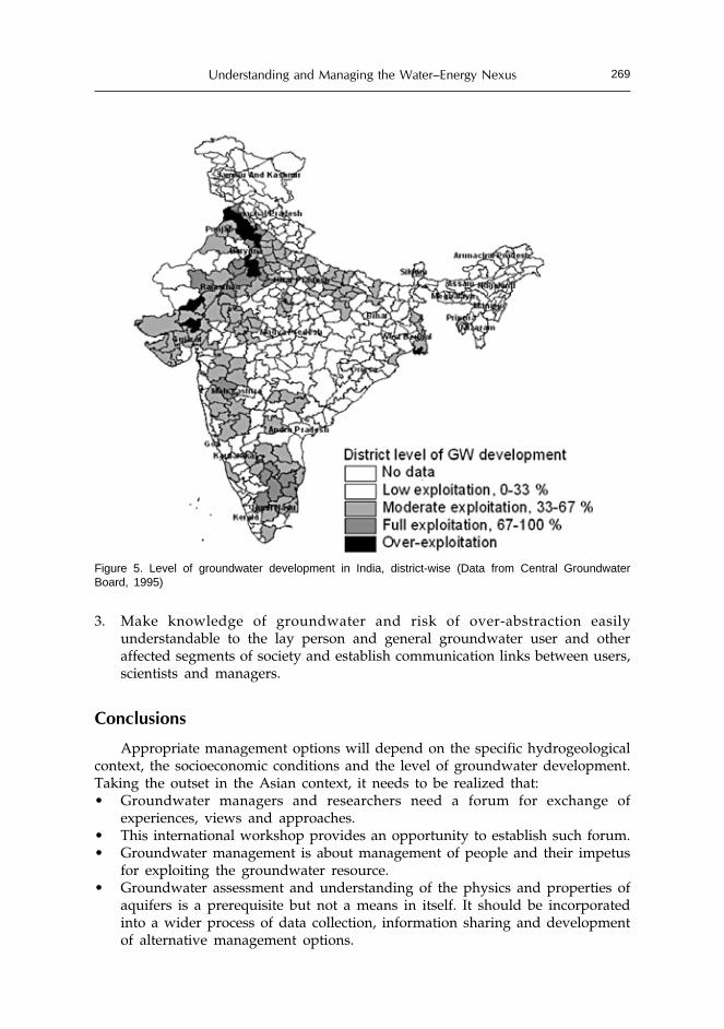
Understanding and Managing the Water–Energy Nexus 269
3. Make knowledge of groundwater and risk of over-abstraction easilyunderstandable to the lay person and general groundwater user and otheraffected segments of society and establish communication links between users,scientists and managers.
Conclusions
Appropriate management options will depend on the specific hydrogeologicalcontext, the socioeconomic conditions and the level of groundwater development.Taking the outset in the Asian context, it needs to be realized that:• Groundwater managers and researchers need a forum for exchange of
experiences, views and approaches.• This international workshop provides an opportunity to establish such forum.• Groundwater management is about management of people and their impetus
for exploiting the groundwater resource.• Groundwater assessment and understanding of the physics and properties of
aquifers is a prerequisite but not a means in itself. It should be incorporatedinto a wider process of data collection, information sharing and developmentof alternative management options.
Figure 5. Level of groundwater development in India, district-wise (Data from Central GroundwaterBoard, 1995)

Shirish Sinha, Bharat R. Sharma and Christopher A. Scott270
• Mutual respect, appreciation, and understanding of roles, experiences andconstraints and a common vision between groundwater managers andresearchers are needed.The Challenge Program on Water and Food2 is funding a project on capacity
building and multidisciplinary learning on groundwater governance in Asia3. Thisprovides a further chance to build partnerships and networks across Asia toaddress general and specific, often shared, groundwater problems.
References
Acreman, M. 2005. Linking science and decision-making: features and experience from environmentalriver flow setting. Env. Modelling & Software, 20: 99-109.
Biggs, T. 2005. Groundwater irrigation and urban reservoir depletion – A case study from central India.
In preparation., International Water Management Institute, South Asia Regional Office,Patancheru, Hyderabad, India.
Central Groundwater Board. 1995. Groundwater Resources of India. CGWB, Ministry of Water Resourcesof India, Faridabad.
Chatterjee, Rana. 2005. Personal communication.Foster, S., Tuinhof, A., Kemper, K., Garduno, H., and Nanni, M. 2003. Characterization of Groundwater
Systems. Briefing Note 2, GW MATE Briefing Note Series. (http://lnweb18.worldbank.org/ESSD/ardext.nsf/18ByDocName/BriefingNoteNo2CharacterizationofGroundwaterSystems—keyconceptsandfrequentmisconceptions/$FILE/BN2.pdf)
G.E.C. (Groundwater Resources Estimation Committee). 1984. Groundwater Estimation Methodology,Report, Ministry of Irrigation, Govt.of India, New Delhi, India.
G.E.C. (Groundwater Resources Estimation Committee). 1997. Groundwater Estimation Methodology,Report, Central Ground Water Board, Ministry of Water Resources, Government of India, NewDelhi, India.
Shah, T., Roy, A.D., Qureshi, A.S. and Wang, J. 2003. Sustaining Asia´s groundwater boom: Anoverview of issues and evidence. Natural Resources Forum 27: 130-141.
Shah, T. 2004. Groundwater and Human Development: Challenges and Opportunities in Livelihoodsand Environment. Presentation, made at the 2004 Stockholm World Water Week. Water Scienceand Technology (Forthcoming).
Tuinhof, A., Dumars, C., Foster, S., Kemper, K., Garduno, H. and Nanni, M. 2003. GroundwaterResource Management - An Introduction to its Scope and Practice. Briefing Note 1, GW-MATEBriefing Note Series. (http://lnweb18.worldbank.org/ESSD/ardext.nsf/18ByDocName/BriefingNote No1 Groundwater Resource Management — An Introduction to its Scopeand Practice/$FILE/BN1.pdf)
2http://www.waterforfood.org/3http://www.iwmi.cgiar.org/iwmi-tata/index.asp?nc=293&id=1002&msid=100