Embed Size (px)
Citation preview
Preface
The rapi
municipa
research
Water Se
based on
represen
refined
individua
consensu
further d
to addre
of ground
Executive
Importan
Groundw
developm
1. Tto
Groundw
A review of
Den
Howard W
d growth in
al, industria
needs and
ecurity (GIW
n extensive
ntatives of t
following m
als on a pre
us of profes
discussion an
ss the need
dwater and
e Summary
nce of groun
water aspect
ment and we
he groundwo a range of
Many comand muni
The majowater sup
The miniprocessesfrom a ma
water, Hydr
f groundwa
the d
nis Peach, Ch
Wheater, Can
Direct
n the Provin
l and agricu
opportunit
WS) and its p
consultatio
the governm
many impo
eliminary dra
ssional opini
nd developm
s and oppor
protection o
ndwater and
ts of the sub
ell‐being of S
water resourcusers. These
mmunities ocipal drinkin
ority of farmpplies; and,
ng and oil s when surfaain river.
rogeology
ter and hyd
developmen
hief Scientist
nada Excelle
or, Global In
nce and incr
ultural deve
ties would b
rovincial pa
ns in Septem
ment, indus
rtant and
aft. We the
ion across t
ment of a co
rtunities fac
of the subsu
d the subsur
bsurface env
Saskatchewa
ces of Saskae include:
utside the mng water sup
mers who re
and gas indace waters a
and Susta
drogeologica
nt of a resea
t (retired), B
ence Researc
nstitute for W
reasing pres
lopment, m
be timely a
rtners. This
mber/Octob
stry and ac
helpful com
erefore belie
these sector
ollaborative f
ced by the P
rface enviro
rface environ
vironment ar
an for severa
atchewan cu
major cities, pplies;
ly on groun
dustries whre not readi
Global Natio
SaTel: (306)
ainability in
al issues for S
arch strategy
British Geolo
ch Chair in W
Water Secur
ssures on g
made it clea
nd helpful,
report was
ber 2013 be
cademic sec
mments an
eve that the
rs. It is inte
framework f
Province in t
onment.
nment to Sa
re of major
al reasons.
urrently prov
which rely o
ndwater for
o use grouly available,
Institute for onal Hydrology
11 Innoaskatoon, SK S) 966-2021; Fa
n Saskatch
Saskatchew
y
ogical Survey
Water Securi
rity
roundwater
r that a str
for the Glo
commission
etween Dr. D
ctors in Sas
nd suggestio
e report rep
nded to pro
for new rese
he sustaina
askatchewan
importance
vide essentia
on groundwa
both dome
ndwater in , for example
Water Secury Research Cenovation BoulevS7N 3H5 Cana
ax: (306) 966-1
hewan
wan and
y
ity and
r associated
rategic revie
obal Institut
ned by GIWS
Denis Peach
skatchewan,
ons from t
presents a b
ovide a bas
earch integr
ble develop
n
to the econ
al water sup
ater for dom
stic and on‐
their extrae due to dist
rityntre vard ada 193
with
ew of
te for
S. It is
h and
, and
these
broad
is for
ration
ment
nomic
pplies
mestic
‐farm
action tance
1
2
2. In times of drought, when surface water supplies face increasing pressure, groundwater
resources provide an important alternative water source, and are therefore a
potentially‐important strategic resource for the Province. We note that drought risk is
likely to increase in a warmer climate, and that the palaeo‐record shows more severe
historical droughts than occurred in the 20th Century.
3. The pore space of geological formations beneath the Prairies is used for the disposal of
waste waters from mining and oil and gas development. The Province is also home to
the Weyburn‐Midale carbon dioxide storage and enhanced oil recovery project and will
host the world’s first operational Carbon Capture and Storage project, which will also
use the deep geological environment to store carbon dioxide produced in a coal fired
power station.
4. Groundwater systems, including those in the Province, are vulnerable to pollution from
domestic, municipal, industrial and agricultural activities. Such pollution is often long‐
lived, and remediation, where possible, is often costly.
5. The role of groundwater in the provision of baseflow to the main rivers is currently
thought to be small, but climate change may mean that it is of growing importance.
Summary of pressures on the subsurface environment – challenges to development
Saskatchewan is currently developing at an unprecedented rate and the provincial government
has placed growth at the top of its agenda in all sectors.
Agricultural production reached 38.4 million tonnes in 2013, achieving the previously set
target of increasing production by 10 million tonnes by 2020, i.e., seven years earlier
than expected. However, 2013 was an exceptionally favourable year. In more normal
years this target will be achieved by changes to agricultural practice, including planting
drought resistant crops, increasing irrigation and other changes in land management,
including precision agriculture. These measures can impact the water environment
(both positively and negatively). Expansion of irrigation from surface water resources is
likely, but this may put stress on surface water resources when droughts occur. Hence in
some areas and under certain circumstances the importance of groundwater will grow
and could become crucial.
In the mining sector, the growth, in particular of potash production, is also
unprecedented. A 90% increase is expected from expansion and extension of existing
potash mines, and with one new mine due to open in the next year and several others
being investigated for development over the next decade as new international mining
companies invest heavily in Saskatchewan, production will grow even further. The life of
a potash mine is many decades, so long‐term security is needed, both of water supply
and for the disposal of waste products, which is normally by injection into the deep
geological formations well below the levels of mining activity. The companies also need
3
to understand the hydrogeological behaviour of the deposits that they are mining to
avoid costly flooding inflows from deep groundwater brines, which can result in mine
closure. As mines run their course and the mineral resource (e.g., uranium or potash)
becomes exhausted at a particular site, mine closure plans are required so the mine, its
waste and the nearby environment remains safe into the distant future. While other
mining activities (e.g., base metals, gold, diamonds) also require secure water supplies,
problems of water resource availability are mainly focused on developments in the
south of the province where potash mining predominates.
The oil and gas sector is also going through a boom period in Saskatchewan and this is
set to continue well into the future with the further development of oil pools (often
using enhanced oil recovery) and natural gas, including oil shale. The biggest expansion
is in oil shale (e.g., in the Bakken formation), where development relies on hydraulic
fracturing (“fracking”) to extract the oil. This requires water which is often supplied from
groundwater. The resultant flowback of contaminated waters requires disposal.
Disposal is normally achieved by re‐injection into the exploited formation, for example
the Mississippian Bakken, or deeper formations. Enhanced Oil Recovery (EOR), by
pressurising oil reservoirs with water or carbon dioxide, is a well‐known practise in
Saskatchewan and will continue for the foreseeable future.
In parallel with the economic growth discussed above, the provincial population is
increasing, resulting in increasing demand on water resources. In areas remote from
surface water sources, groundwater is an important resource, and there are associated
pressures for increased use of groundwater for domestic and municipal supply, for
example, in the Regina East area.
Science needs to support sustainable development
The Province faces the challenges of a large land area with a complex geology, and a small
population. In that context, it has made exemplary strides to develop the knowledge base, for
example by a progressive programme of hydrogeological mapping. However, looking to the
future, the sustainable development of the subsurface will benefit greatly from improved
scientific understanding of groundwater in a number of key areas. The science challenges are
summarised here. Below, we turn to the opportunities for knowledge development and
mobilisation.
Although many communities rely on groundwater for their domestic water supply, the further
development of groundwater supplies may be hampered by uncertainty over reliable long‐term
yield and storage replenishment, for example, due to a very long drought or under growing
demand. As more groundwater resources are used and needed in the future, further
understanding of long‐term recharge, aquifer morphology and inter‐connections with both
4
surface water and other aquifers, the integrity of aquitards and cap rocks between these
aquifers, and groundwater quality will be required for their safe and sustainable development.
If groundwater is to be considered as a strategic resource, for instance in times of severe
drought, then quantification of the storage water and its ability to be replenished will be
important to bring confidence in its reliability.
Saskatchewan is heavily reliant on the South Saskatchewan River for growth and development
and the current and future role of groundwater in sustaining baseflow is presently a matter for
conjecture, with little study. This scientific evidence is likely to become more important with
climate change and changes in weather pattern and warming winters.
It is clear that energy and mineral resource extraction and waste disposal into the deep geology
are growing rapidly, but the knowledge of where these waste fluids flow in the deep geology is
not clear. There are challenges for science in understanding the nature of aquifers, aquitards
and cap rocks, well‐bore integrity (especially of wells drilled in 1950’s and 60’s) and interactions
between activities and between groundwaters in differing formations up and down the
Saskatchewan stratigraphy. As the use of groundwater resources grows to supply the growing
population and industrial requirements, a greater level of knowledge than has been necessary
to date is likely to be required to ensure sustainability.
Saskatchewan has many aquifers that can be subdivided into three types:
1. deep saline aquifers currently used for waste disposal;
2. intermediate depth aquifers, beneath the Quaternary, and cross‐cutting buried valley
aquifers with uncertain recharge and resource capacity and variable water quality, but
sometimes used for potable domestic supplies; and,
3. shallow Quaternary aquifers used in rural communities and towns, typically with
uncertain geometry, inter‐relationships and recharge.
These aquifers are separated or isolated from each other by aquitards, often thick clay or shale
deposits. Their ability to protect, isolate and seal is also fundamental to the future management
of the subsurface environment. The relationships and interactions between these different
aquifers and aquitards are not well defined, so allocation and sustainability decisions are a
challenge. As greater use of the subsurface is made, for mineral and energy resource
development, for water supply and for waste disposal, the challenge seems likely to grow.
Investments that are currently being made in the oil and gas and mining industries are large. To
make these investments, which secure the economic future of Saskatchewan and have an
important positive boost for all of Canada, there is an important role for improved
understanding of long‐term water security, waste management and environmental risks.
5
The needs for Highly Qualified Personnel (HQP)
Individuals with the skills required to fill the knowledge gaps and provide informed decision‐
making are scarce. Although the Province has internationally‐important skills and experience in
many areas, with the exception of a small number of young Faculty and government scientists
with related expertise, much of the hydrogeological knowledge of groundwater and
hydrogeology of Saskatchewan lies in a few retired or near retiring personnel. The expertise
within government is limited to a small number of individuals, and some can be found with
consultant firms. However, the limited breadth of a skilled base seems likely to prove
problematic in the near future.
Key Recommendations
The key recommendations made below are of a strategic nature. The role of the Global Institute
for Water Security and the University of Saskatchewan has not been specified. Leadership may
more appropriately fall to the Provincial government and its agencies or to industry, or may be
best served by academia, or, perhaps ideally, a partnership of all three.
Our recommendations are:
1. Coordinate groundwater and hydrogeological research. Currently, the groundwater and hydrogeological science base is fragmented between multiple stakeholders including: industry (mining, oil and gas, water supply, agriculture); Saskatchewan Water Security Agency (SWSA); Saskatchewan Ministries of Economy, Environment, Agriculture and Health. Research is also uncoordinated between a variety of research organisations and institutes.
2. Conduct an audit of groundwater and hydrogeological research, data and knowledge and make the results accessible, as much as possible, via an integrated web‐portal.
3. Begin a programme and seek funding from relevant stakeholders to further develop the knowledge base required for robust evidence‐based decision‐making. Priorities should be set by a panel comprising stakeholders and academia.
4. Develop a comprehensive Sustainable Groundwater Management Plan for the Province with input from relevant stakeholders, academia and the public at large.
5. Review the management and regulatory practices and framework to ensure that development proceeds as fast and as sustainably as possible, in light of the new knowledge being produced, the rapid growth that has occurred and increasing competition for groundwater and pore space in deep geological formations.
6. Develop training opportunities for HQP to meet the needs of government, industry and the university sector for hydrogeological and related expertise.
Conclusion
The massive development of agriculture and natural resources in Saskatchewan, set within the
context of a warming climate, presents environmental challenges to science and management.
6
There is an important need for new research and survey to provide the basis for sound
management in the face of increasing pressures. The knowledge amassed over the last few
decades and the high level of skills of the managers and scientists mean that Saskatchewan is in
an excellent position to meet those challenges, but action is needed now to support the
development of appropriate strategies to ensure sustainable development over the next
several decades.
7
1. Introduction – the strategic context for the review and relevant Provincial initiatives
The University of Saskatchewan (U of S) launched the Global Institute for Water Security (GIWS)
on 22 March 2011 with a vision to be a driving force for research into global water security
issues and their local implications. GIWS is funded through the Canada Excellence Research
Chair (CERC) in Water Security initiative which received a $30 million, joint federal‐provincial‐
university commitment over seven years beginning in 2010. The Institute’s research is focused
on sustainable use of water resources and protection against flood and drought hazards. Multi‐
disciplinary science, engineering and social science teams work with industrial and government
partners to address four broad water security issues: climate change and its impacts on water
resources, land use change, sustainable development of natural resources, and socio‐hydrology
(the human and decision‐making aspects of water resource development).
GIWS seeks to improve monitoring, understanding and modelling in these areas of endeavour,
and in particular, to address issues relevant to the Province of Saskatchewan. Since March
2011, efforts have concentrated on surface water quantity and quality, with less attention paid
to groundwater. It is has become increasingly clear, however, the Institute’s interest in carrying
out research to better manage water resources in the face of societal and environmental
change applies equally to groundwater and surface water, and there are significant, but
uncertain, linkages between the two. Hence the GIWS commissioned a review of issues around
groundwater knowledge and management with the goal to develop a future research program
to address deficit areas and inform decision‐making. The review was carried out by Dr. Denis
Peach, recently retired Chief Scientist of the British Geological Survey and an expert in
hydrogeology. The scope of service and review methodology is outlined in Appendix 1. A list of
personnel and organisations consulted can be found in Appendix 2.
Growing interest in groundwater at the U of S dovetails nicely with other active or recently
launched Provincial research initiatives including:
the Petroleum Technology Research Centre (PTRC) (opened in 2000);
the Sylvia Fedoruk Canadian Centre for Nuclear Innovation (Fedoruk Centre) (launched
2011);
the Global Institute for Food Security (GIFS) (established December 2012); and,
the International Minerals Innovation Institute (IMII) (launched May 2012).
Further information about these institutes can be found in Appendix 3. The PTRC managed the
largest Enhanced Oil Recovery and carbon dioxide storage research project in the world ($46
million) between 2000 and 2012. The PTRC does not conduct in‐house research, but
commissions outside researchers from Canadian and international universities and research
institutes to undertake research related to the oil and gas industry. Similarly, the Fedoruk
8
Centre, GIFS and IMII commission research, but do not carry it out themselves. In contrast,
GIWS partners with government and industry to produce both applied and fundamental
research related to water security. Given the overlapping missions and management models of
the various institutes, it makes sense for one of them, in this case GIWS, to take a leadership
role to promote research to ensure that there exists broad holistic coverage of society’s need
for groundwater and hydrogeological knowledge, including groundwater quality, quantity and
links to surface water.
2. Economic, social and environmental drivers and the role of groundwater and
hydrogeological science – the global context
Groundwater is under increasing pressure world‐wide from over‐abstraction and degradation
of its quality. It is a vital source of water to many rural communities, but also for municipal,
industrial and agricultural water supply. Even in places where surface water is normally
plentiful, groundwater can be an important resource in times of drought. However, it is
vulnerable to pollution, and due to long travel times between aquifer recharge and discharge,
contaminants, once present, can persist in groundwater for decades or even centuries. It is of
course, ‘out of sight’, and hence often ‘out of mind’. While groundwater is often a cheap
resource to develop, monitoring and investigation are expensive. There are thus major
challenges to quantify the extent of groundwater resources and their quality, the natural
recharge (and hence sustainable supply), the long‐term impacts of abstractions and waste
disposals, the impact of resource development (mining and oil and gas exploitation), and hence
to provide the information needed for sustainable development.
There are a number of global drivers of change that are relevant to the development and
protection of groundwater resources in Canada and most particularly Saskatchewan. These
include increasing demand for water, from population growth and economic development,
increasing need to safely and sustainably dispose of wastes to the subsurface, increasing
pressures on groundwater quality, from domestic, agricultural and industrial activities, and
concerns for climate variability and change, including increasing drought and flood risk.
The water‐energy nexus is often discussed in the context of hydropower and surface water, but
the global search for cheap and sustainable energy has direct impacts on groundwater flows
and quality. Oil and gas exploitation from the natural environment clearly occurs in the
subsurface where groundwater in some form is ubiquitous. The processes involved in
exploitation require water and often involve the injection of fluids into the geological reservoir.
For example, hydraulic fracturing or “fracking” has emerged as an important process for
enhancing the recovery of oil from oil shale and shale gas, but has gained a degree of public
notoriety in the United States and Europe. Both processes require water and produce volumes
of contaminated water (co‐produced and flowback), which are usually re‐injected into the
9
exploited or deeper geological formations. The generation of nuclear energy requires the
mining of uranium and the disposal or temporary storage of mine waste in tailings ponds, which
has the potential to interact with the environment, including surface water courses and
groundwater. The generation of nuclear energy produces radioactive waste which must be
either stored or more likely contained in a (hydro) geological environment, for many tens of
thousands of years, before it can be deemed safe. Coal‐based energy production similarly raises
issues of groundwater protection; these include pollution from abandoned mines and the
associated need for management of acid mine drainage, as well as issues of power station
atmospheric emissions and ‘acid rain’.
Groundwater issues associated with resource development extend well beyond the energy
industries. More generally, the development of subsurface resources involves possible
interactions of resource development on the groundwater environment, and issues where
knowledge of groundwater flow and hydrogeochemical behaviour is essential for safe
management of these activities. For example, the ten potash mines in Saskatchewan produce
large volumes of brine (particularly where solution mining is practised) which is normally
disposed of by injection into geological horizons much deeper that the mined formations.
Groundwater is also intimately linked to food and other agricultural production. Agriculture
uses water for irrigation, livestock watering and other on‐farm activities, and, globally and
locally, groundwater plays a key role in providing water for some or all of these needs. In
addition, agricultural land management changes the hydrological cycle and water quality, with
impacts on groundwater recharge (and hence sustainability) and on groundwater quality.
In addition to its role as a key water resource in times of drought, groundwater is an important
element in many other natural hazards including earthquakes, landslides and floods. In
particular, groundwater is an often overlooked aspect of flooding, both in river floodplains and
internal drainage basins. More generally, groundwater is important in maintaining baseflows in
rivers and, as noted above, in the case of meteorological drought and limited surface water
resources, groundwater storage is undoubtedly the most important global reservoir we have to
draw upon in such times of water scarcity.
Notwithstanding these issues, the biggest drivers of governments and peoples are undoubtedly
economics and societal culture. The “growth agenda” is firmly the aspiration of all nations as
the world pulls itself slowly out of the financial instability and economic weakness of the last
five years. However, it is now accepted and policy of many governments, including those of
Saskatchewan and Canada, that what we do must be sustainable and represent value for
money. The consequences of our actions and our decisions must be based on evidence and we
need to be able to make forecasts, and if possible predict what might happen in the future,
under changing circumstances and varying stresses. As our population grows and our demands
10
for ever higher standards of living continue, the speed of change and the pressures on the
water environment also increase. Given the increasing pressures on groundwater quantity and
quality outlined above, there is an increasing need for improved understanding to support
sustainable natural resource exploitation and the development of groundwater resources.
3. Water Demand and Use in Saskatchewan
Total Water Demand and Use
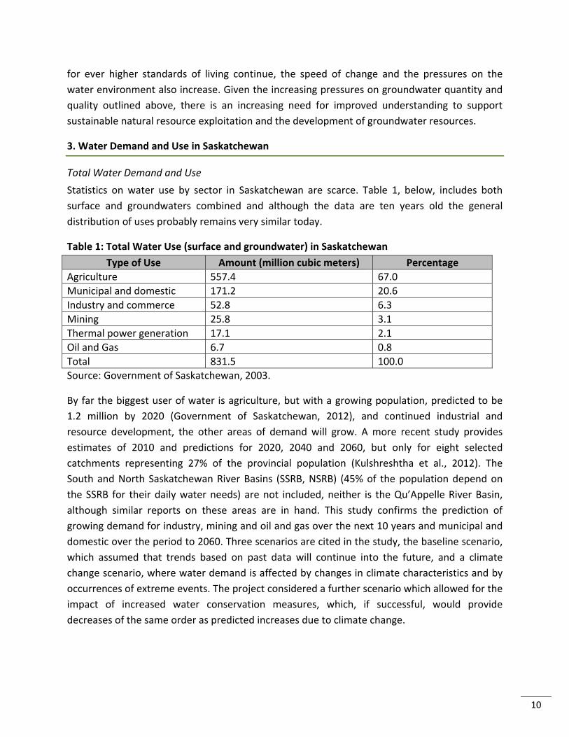
Statistics on water use by sector in Saskatchewan are scarce. Table 1, below, includes both
surface and groundwaters combined and although the data are ten years old the general
distribution of uses probably remains very similar today.
Table 1: Total Water Use (surface and groundwater) in Saskatchewan
Type of Use Amount (million cubic meters) Percentage
Agriculture 557.4 67.0
Municipal and domestic 171.2 20.6
Industry and commerce 52.8 6.3
Mining 25.8 3.1
Thermal power generation 17.1 2.1
Oil and Gas 6.7 0.8
Total 831.5 100.0
Source: Government of Saskatchewan, 2003.
By far the biggest user of water is agriculture, but with a growing population, predicted to be
1.2 million by 2020 (Government of Saskatchewan, 2012), and continued industrial and
resource development, the other areas of demand will grow. A more recent study provides
estimates of 2010 and predictions for 2020, 2040 and 2060, but only for eight selected
catchments representing 27% of the provincial population (Kulshreshtha et al., 2012). The
South and North Saskatchewan River Basins (SSRB, NSRB) (45% of the population depend on
the SSRB for their daily water needs) are not included, neither is the Qu’Appelle River Basin,
although similar reports on these areas are in hand. This study confirms the prediction of
growing demand for industry, mining and oil and gas over the next 10 years and municipal and
domestic over the period to 2060. Three scenarios are cited in the study, the baseline scenario,
which assumed that trends based on past data will continue into the future, and a climate
change scenario, where water demand is affected by changes in climate characteristics and by
occurrences of extreme events. The project considered a further scenario which allowed for the
impact of increased water conservation measures, which, if successful, would provide
decreases of the same order as predicted increases due to climate change.
11
Summary of Total Water Demand in 8 Selected Basins for the Baseline and Climate Change Scenario from Kulshreshtha et al., 2012
The total water demand in the eight river basins for the baseline scenario is 2.5 million dam3 of
which direct anthropogenic demands made up only about 395,000 dam3 in 2010. The largest
demand is from agriculture at over 300,000 dam3 which is expected to increase to 310,804
dam3 by 2060. The industry/mining water demand is the next largest demand sector estimated
at 59,000 dam3 increasing to 66,171 dam3 by 2020, but then expected to decrease by 2060 to
34,000 dam3. This decrease is primarily a result of assuming declining oil and gas production in
these basins in later decades. However, oil and gas extraction in Saskatchewan seems likely to
continue at increasing rates for the next 10‐20 years, as does potash mining (see Section 4).
The municipal/domestic water demand is the third largest water using sector in these basins
and is predicted to increase by 17.3% over the 2010 level by 2060. This is the fastest growing
sector for the eight basins combined.
Under a climate change scenario the total water demand for the eight Saskatchewan basins is
expected to increase by 10.7% by 2060. Moreover, the water demand for agricultural purposes
is expected to be affected most noticeably by climatic changes, increasing by 17.6% of the
baseline scenario by 2060. The other sectors’ water demands indicate slight increases in
comparison to the baseline scenario. Indirect anthropogenic water demands (mainly
evaporation) are also expected to increase under this scenario by 10%.
Irrigation
Starting in the southwest of the Province during the initial settlement, irrigation projects were
developed by capturing the spring snow melt and run‐off. Irrigation expansion continued with
intermittent growth through the 20th Century to approach 350,000 acres. By the 1990s
irrigation expansion had slowed (Clifton Associates Ltd., 2008). New irrigation infill and
development projects have been identified (Clifton Associates Ltd., 2008) in all regions of
Saskatchewan. In total it is estimated that there may be as much as two million acres of
irrigable lands in the Province. Should development of this scale take place, then water demand
would increase considerably.
Groundwater Use and Demand
Groundwater is the primary source of drinking water for over 50% of rural consumers in
Saskatchewan. An adequate supply of groundwater is necessary to supply drinking water
demands. It is also an important resource for industry, irrigation and agriculture (Davies and
Hanley, 2010).
12
Obtaining accurate and current information on quantities of groundwater used and the type of
use in Saskatchewan (or in Canada as a whole) is difficult, and there are many inconsistencies
and inaccuracies in data (Rutherford, 2004.) This is confirmed by the Saskatchewan Watershed
Authority (now the Water Security Agency) in their State of the Watershed Report for 2010
(Davies and Hanley, 2010) which characterised Groundwater Quantity indicators as follows:
Status: Quantifying groundwater is challenging due to the lack of available data. Therefore, this
indicator is considered “under construction.”
Trend: Trends in groundwater quantity cannot currently be assessed due to the lack of available
data.
In 1996, 435,941 people were said to be reliant on groundwater in Saskatchewan i.e., 42.8% of
the population of the province (Rutherford, 2004). This estimate includes rural supplies
(unlicensed) and municipal supplies. The total has almost certainly decreased considerably, by
well over 200,000, since this time due to the Regina (population 210,556 (Statistics Canada,
2012)) municipal supply, and that of other peri‐urban communities, being changed to surface
water. Nevertheless, groundwater is still the main source of water for communities surrounding
the city of Regina and it seems likely that industrial uses will have increased, due to increasing
mining and oil and gas development (see later). In 2004, 52.42% of groundwater use was for
industrial purposes, the vast majority of which was for oil and gas recovery, cooling water and
mining (Rutherford, 2004).
It seems reasonable to forecast that oil and gas development will continue to grow over the
next decade or more (Government of Saskatchewan, 2013a) and will need to use groundwater
because of a scarcity of surface resources in some areas, in particular in the south and
southwest. In some areas where oil and gas extraction is active and likely to grow there are
significant regions of internal drainage. A significant part of Saskatchewan River drainage, never
enters the wider drainage system, even during extremely wet years, contributing only to small
local lakes and wetlands of internal drainage basins (NRCan, 2010), so access to surface water
resources can be limited.
Although very little groundwater is reportedly attributed to agricultural use (Rutherford, 2004),
the farmers themselves largely rely on groundwater for their domestic supplies, and in many
cases for on‐farm uses, so it is essential in support of agriculture and its development in
Saskatchewan.
All water used by industry not on municipal systems is reported to SWSA, whether ground or
surface water. In addition, all water used by all communities on a licenced treatment system is
reported by month annually. The only groundwater use not reported is by domestic users
13
which are unlicensed, but which can be estimated and is relatively small. Information is
available to the public on request.
Nevertheless, aggregated data concerning groundwater demand and use in Saskatchewan are
not easily obtainable and this may be an area where further research is required or data and
information integration needed to provide for more certainty in planning or highlighting
research areas for the future.
4. Development in Saskatchewan
The Government of Saskatchewan has stated that growth is its primary concern and aim in its
“Plan for Growth – a 2020 vision and beyond” (Government of Saskatchewan, 2012). This is
seen across the agricultural sector, and those of oil and gas and minerals. The government
wishes to achieve substantial growth by encouraging investment, whilst containing public
expenditure and reducing government debt. The energy and mineral extraction sectors, in
2012, contributed approximately 21.8% to the provincial Gross Domestic Product (GDP) and
agriculture contributed about 5% (Statistics Canada, 2013 http://www5.statcan.gc.ca/cansim/).
The growth plan has a target to double the value of all of Saskatchewan’s exports by 2020.
4.1 Agricultural Sector
The growth plan sets out aims to increase crop production by 10 million tonnes and to increase
exports of agricultural and food products from $10 billion to $15 billion by 2020. The first of
these targets was surpassed in 2013 when crop production reached 38.4 million tonnes
(Government of Saskatchewan, 2014). Nevertheless, in order to maintain this as a long‐term
average in a sustainable way, changes are to be expected in agricultural practice. This means
that either crops must be developed that produce higher yields for the same soil
quality/nutrient supply and crop water intake, or the efficiency of these inputs has to be
increased by some method (Council of Canadian Academies, 2013). There will be considerable
efforts put into crop research and development as envisaged, for example, by the initiation of
the GIFS. However, the Saskatchewan Ministry of Agriculture also plans to increase irrigated
area in the province (Government of Saskatchewan, 2012), which will require more of the flows
from the South Saskatchewan River to be allocated for this purpose. Currently there is a surplus
of water available for irrigation, but as more of these resources are used to supply the mining
industry and the growing population and in the event of long‐term drought, water resource
availability is likely to become a bigger issue. The Canadian Prairies are very liable to drought,
mainly because of the high variability of precipitation, both spatially and temporally (Bonsal and
Wheaton, 2005). The Prairies experienced multi‐year droughts in the 1890s, 1910s, 1930s,
1960s and 1980s and most recently from 1999 to 2005 (Gan, 2000; Lawford, 1992; Hanesiak, et
al., 2011). Recent research by Bonsal, et al. (2013) suggests that droughts in the palaeo‐record
14
from 1400 were more severe than those of the 20th century. Groundwater, currently very
much a secondary resource, is now becoming a much more important consideration in long‐
term planning.
Farmers and their families largely rely on groundwater for their domestic supplies, for any food
processing that they need to carry out and for cleaning and stock rearing purposes. It has been
estimated that there are over 81,000 private wells in operation in the province (pers. com. K.
Lo, Saskatchewan Water Security Agency from the Wells database). The current quality of these
well waters is believed to be poor in comparison with municipal supplies derived from surface
water. Between 4% and 10% of all community and farm groundwater supplies suffer from high
levels of arsenic and selenium (Olkowski, 2009; pers. com. K. McCullum, Saskatchewan Ministry
of Environment). This is not pollution, but results from leaching of naturally occurring minerals
in the Quaternary deposits into groundwaters (Thompson, et al., 1999). However, a 2001
survey (Thompson, 2001) showed that 14.1% of the 3,425 private wells sampled in this study
had concentrations of nitrate exceeding Canadian drinking water standards. While some nitrate
may be present due to natural sources, the major anthropogenic sources are domestic sewage
disposal, livestock operations and use of nitrate‐based fertilizers (although use of the latter in
Saskatchewan is much less intensive than, for example, in Europe). Thus, further work may be
required to ascertain the source of this contamination. Nitrate and bacteriological
contamination is suggested to occur in about 40% of wells in Saskatchewan
(http://www.ppwb.ca/information/106/index.html, 2009). Currently water quality of these
groundwater supplies is not regularly monitored, and unlike public water suppliers, the owners
of private supplies are not required to have their water tested (Thompson, 2003).
4.2 Mineral Sector
Recently the potash mining industry has seen considerable activity with the influx of
multinational mining companies who wish to open new mines. K+S Potash has set up in Canada
to open a new potash mine at Legacy, and BHP Billiton (BHP) is aiming to open the first of
perhaps five mines, the Jansen project, by 2020 and will initially be investing $2.6 billion. Potash
exports from Saskatchewan have increased by 127% since 2007 (Government of Saskatchewan,
2012). The potash mining process both uses water and produces highly concentrated brines
which must be disposed of to the environment in some way. The industry also uses water for
mining and processing. Currently most water resource requirements are supplied from surface
sources, much from the South Saskatchewan River system by SaskWater, which is
Saskatchewan’s commercial Crown water utility, but there are some groundwater allocations
and other surface water sources used. Currently, planned production for the 10 operating
potash mines will see a 90% increase by 2023 (Government of Saskatchewan, 2013a). New
mines, including the Legacy and Jansen projects, will clearly increase production further and, if
15
BHP realise their current vision of five new mines over the next decade or so, production levels
will increase even more, further increasing the process water and brine disposal requirements.
As development reaches deeper levels in the Prairie Evaporite deposits (see Appendix 5),
extraction will move more towards dissolution mining by injection of waters with relatively low
total dissolved solids to dissolve the potash mineral.
The importance of water resources planning under extreme droughts was highlighted by the
1999‐2005 drought (Hanesiak et al., 2011). Security of water resources is of concern to the
potash industry. While the GIWS has been instrumental in modelling the South Saskatchewan
River System in terms of total resource availability (although this does not include
groundwater), BHP, as is their business policy to assure themselves of the risks involved, has
developed their own water resources model during their assessments of the feasibility of
potash mining in Saskatchewan.
Another issue that the potash mining companies take very seriously is that of water, normally
brine, ingress into their mines, which can cause mine closure and considerable loss of
production and income. These often catastrophic inflows occur because of mining into collapse
features in the evaporate deposits which are full of water or allow water ingress from other
strata. Greater understanding of how and why these occur would aid risk management by the
mining companies and assist in planning mine development, thereby fostering growth and
investment.
Mining of other minerals in Saskatchewan, except for uranium, is less important, from a water
perspective, in comparison to that of potash, but individual, site specific problems may need
research. Uranium mining is carried out in the north in the Athabasca Basin and the water
resource issues associated with the activity, which include dealing with dewatering, as well as
wastes, tailings ponds, mine closure and protecting fragile wetland surface water
environments, have been the subject of considerable research. The industry is heavily federally
and provincially regulated to ensure the protection of society and the environment. However,
there is growing concern by environmental NGOs (pers. com. K. McCullum, Saskatchewan
Ministry of Environment) regarding protection of the wetland habitats. Research efforts into
transport of contaminants via groundwater from waste tailings and ponds to the environment
and the safe closure of mines sponsored by industry and government will continue.
4.3 Oil and Gas Sector
Since 2007, Saskatchewan’s crude oil exports have grown by approximately 48% (Government
of Saskatchewan, 2012). In 2011, Saskatchewan exported more than $10 billion in crude oil
(Government of Saskatchewan, 2012) and in 2012, crude oil production in the province reached
172.9 million barrels (from an estimated 29,600 wells), up more than 7% from the previous
16
record of 161.0 million barrels set in 2008 (Government of Saskatchewan, 2013a,
http://economy.gov.sk.ca/OilGas). The combined value of oil and gas sales for 2012 was
estimated at $12.6 billion and the industry continues to be one of the largest contributors to
the Saskatchewan economy ($1.4 billion in revenue (Government of Saskatchewan, 2013b))
and provides more than 34,000 direct and indirect jobs to people in the Province.
Saskatchewan is the second largest oil producing province in Canada and has an estimated 1.1
billion barrels of remaining recoverable crude oil reserves.
The Province is going through an oil boom, led by the development of the Bakken play and the
use of fracking and water flooding technology. The development of horizontal drilling and
fracking techniques was led by industry research in Saskatchewan. Water is an increasingly
important issue since it is required for reservoir flooding and fracking. Co‐produced and flow‐
back water is of poor quality. This can, to some extent, be recycled, but some must be disposed
of by injection through boreholes to the deep geological formations well below the producing
levels.
There seems no doubt that the development of oil resources will continue, particularly in the
south of the Province, which is a water scarce region. Crescent Point Energy Corporation (CPE)
consider water security an issue they must take very seriously and they are developing a water
management plan to deal with both the water scarcity issues and disposal challenges. They
have conducted a SWOT (Strengths, Weaknesses, Opportunities and Threats) analysis on their
water management practises and the following weaknesses and threats were identified as
relevant to their operations in Saskatchewan (Delphi Group, 2013).
Weaknesses
Data management (tracking and reporting)
No annual water (or environmental) reporting to stakeholders (e.g., sustainability / corporate responsibility report)
No formal water management plan
Limited water reuse or recycling in drilling and completions operations Threats
Flood vulnerability in Southeast Saskatchewan
Emerging policies (especially with respect to hydraulic fracturing)
Increased activity in Bakken play: more demand on regional water resources
Public perception of hydraulic fracturing (social license)
Water license delays
Operating in several water‐short areas (Southern Alberta, Southwest Saskatchewan, potentially Southeast Saskatchewan, and Utah)
17
CPE have made it clear to GIWS they are interested in developing joint research programmes in
the groundwater/hydrogeology area. They are often reliant on groundwater resources for the
further development of their oil resources. These views were echoed by the Chief Geologist of
the Saskatchewan Geological Survey (pers. com. G. Delaney). Natural gas has been developed in
the Swift Current area, but remains less important, at the present time, than oil and oil shale.
New oil plays are likely to be developed in the Jurassic Shaunavon Formation and the low
permeability, high porosity Mississipian‐Devonian Bakken. Heavy oil is likely to be further
developed from the Cretaceous Manneville Group and horizontal drilling and multi‐stage frac
completions are resulting in a resurgence of development in the Cretaceous Viking Formation.
Regarding other oil and gas developments, it is possible that oil sands might be developed on
the Saskatchewan – Alberta border, most likely using in‐situ recovery techniques such as steam‐
assisted gravity drainage. Oil sands water issues are not dealt with in this report as the province
of Alberta is the main focus for current development. However, GIWS researchers are involved
in oil sands research and also contributed to the Alberta Provincial Environmental Monitoring
Panel (AEMP, 2011). It also seems likely under the current global “dash for gas” that shale gas
prospects, which are likely to be plentiful in Saskatchewan, will be developed in the future.
These are exploited with fracking similarly to oil shale, but currently these prospects are not a
priority for the industry.
4.4 Other development activities which will impact on hydrogeology or groundwater
resources
The widely published International Energy Agency Greenhouse Gas Weyburn‐Midale Carbon
Dioxide Monitoring and Storage Project was carried out at the sites of commercial scale
Enhanced Oil Recovery (EOR) projects being undertaken by Cenovus Energy Inc. (Weyburn) and
Apache Canada Ltd. (Midale). This world‐leading research was managed by the PTRC and used
the aforementioned EOR operations as a means of studying the geological storage of carbon
dioxide (CO2) on an industrial scale. The research phase of this project ended in 2012 (Hitchon,
2012). The Government of Canada has committed $240 million for the Boundary Dam
Integrated Carbon Capture and Storage (CCS) Demonstration Project. This will retrofit and
extend the life of Unit 3 of the Boundary Dam coal‐fired electricity generating plant. SaskPower,
the provincial Crown electricity utility, is contributing $1 billion. The project will capture up to
one million tonnes of CO2 per year which will be available for EOR operations. This is the largest
and the first commercial scale Carbon Capture and Storage demonstration project in the world.
The SaskPower CCS Global Consortium was created so that partners can gain comprehensive
knowledge and explore the commercial viability of CCS (Government of Saskatchewan, 2013b).
Aquistore is an independent research and monitoring project (http://aquistore.ca/), managed
by the PTRC, which aims to demonstrate that storing liquid CO2 by injecting it into the saline
18
Deadwood formation (3,400m depth), rather than using it in active oil producing zones for EOR,
is a safe, workable solution to reduce greenhouse gases. This will be yet another activity that
uses the hydrogeology of the Western Canadian Sedimentary Basin (WCSB) to dispose of a
contaminated fluid. If successful, this practise will become much more prevalent the world
over, not just in Saskatchewan. Further developments using the subsurface that are or have
been investigated or considered, include geothermal energy development and aquifer storage
and recovery or other artificial recharge techniques using surface water during wet years.
Another development currently being considered is the geological disposal of radioactive waste
in the subsurface. The Nuclear Waste Management Organisation (NWMO) of Canada is at the
early stages of a process to safely dispose to the subsurface its nuclear waste under an Adaptive
Phased Management Strategy (Nuclear Waste Management Organisation, 2013). So far 20
communities have expressed interest to be considered for the project. The NWMO has
completed preliminary assessments on eight of these, three of which were in Saskatchewan. Of
these community expressions of interest, the NWMO has determined that three, one in
Saskatchewan (Creighton), have been identified for Phase 2 study. Currently this is the only site
being considered for radioactive waste disposal in Saskatchewan and it is situated in the
Northwest of the province on granitic rocks. Geological disposal of intermediate‐ and low‐level
radioactive waste materials is being considered at the Bruce Nuclear Power plant in Ontario.
The lithologies at the level of the projected repository consist of low permeability limestones
and shales overlain by thick shales (www.nwmo.ca/dgrsubmission).
A summary of development activities in Saskatchewan that are likely to have an impact on
groundwater systems is given in Appendix 4.
5. Legal Frameworks for the groundwater and hydrogeological environment
The management of groundwater in Saskatchewan originated with English Common
Law. Under the rule of absolute capture, a land owner was entitled to the use of groundwater
that was overlain by their property with little or no consideration of impacts to the aquifer or
other users. Aspects of this rule continue today, with the domestic use of groundwater, as it is
narrowly defined, exempt from some regulatory requirements under current legislation.
In 1959, Saskatchewan proclaimed The Ground Water Conservation Act, followed in 1966 by
The Ground Water Conservation Act, Regulations. Together the act and regulations were
intended to conserve and protect groundwater resources by regulating the drilling of wells. The
act also allowed for the regulation of groundwater use through a licencing process similar to
what was already in place for surface water allocations. These approval processes allowed for
the protection of the aquifer from exploitation and contamination, and protected the rights of
existing licenced users from competing demands.
19
The Ground Water Conservation Act was repealed in 2005 with proclamation of The Watershed
Authority Act, 2005, now The Water Security Agency Act. Under the current legislation, the
allocation of surface and groundwater has been combined under a single licencing regime. The
Ground Water Conservation Act, Regulations remain in force and continue to regulate the
drilling and completion of wells.
Under the Water Security Agency Act, all groundwater use, except domestic, requires an
Approval. Examples of works which require approval are: municipal, industrial (including
groundwater de‐watering), intensive livestock operations, commercial, public institutions and
irrigation. The intent of the Water Security Agency’s approval process for groundwater projects
is to ensure the sustainable and environmentally sound development of the province’s
groundwater resources. The regulations require investigation to be carried out to assess the
potential impact of groundwater abstraction on other users and on the resource.
Regulation of the mineral extraction and oil and gas industries falls under the Ministry of
Economy, which is home to the Saskatchewan Geological Survey which provides the science
expertise. This regulation covers mineral exploration boreholes, mineral waste disposal
boreholes and operations, oil and gas production or injection wells and this takes place under a
complex set of different legal instruments and regulations. The same is true of reporting
requirements for the various mining and oil and gas operations. For example, the Potash and
Salt mining activities are controlled under the Alkali Mining regulations, whereas the mining of
base metals, uranium, etc. and oil and gas are controlled under a different set of regulations.
The rapid growth of the development of natural resources in Saskatchewan and the intimate
relationships between these activities and the groundwater and hydrogeological environment
leads to the conclusion that there is an increasing need for coordination and a streamlined
approach to further encourage development. In light of the new knowledge being produced
and this rapid growth, review of the management and regulatory practices and framework to
ensure that development proceeds as fast and as sustainably as possible, seems a prudent
course.
6. Groundwater and Hydrogeological Knowledge in Saskatchewan
There has been considerable investment by government in the mapping of the geology of
Saskatchewan to support mineral and oil and gas development and to facilitate the
development of groundwater supplies. The WSA and its predessessors have also developed an
excellent database of hydrogeological maps which is currently being updated. Recent and
current work of Natural Resources Canada, in particular on buried valley aquifers, is also
important (Cummings, et al., 2012). Some studies into regional impacts of CO2 and other fluid
injections into the Basal Cambrian aquifers have been undertaken in the prairie provinces (e.g.,
20
Rebscher, et al., 2012) and further work involving the Geological Survey of Saskatchewan is
current. In addition, the Saskatchewan Research Council has, over that last few dacades, carried
out considerable research and data collection as have many researchers in the university and
government sectors. In particular, the work of Christiansen on Quaternary stratigraphy (e.g.,
Christiansen and Sauer, 2002), van der Kamp on many aspects of physical hydrogeology (e.g.,
van der Kamp, 1989; van der Kamp and Hayashi, 1998; van der Kamp and Maathuis, 2006,
2012), Hendry on aquitards and isotope hydrogeology (e.g., Hendry, 1988; Hendry, et al., 2013),
Maathuis on regional hydrogeology (e.g., Maathuis, 2005; Maathuis and Simpson, 2006;
Maathuis and van der Kamp, 2011) and Hayashi on processes and other aspects (e.g., Hayashi
et al., 1998a, 1998b; van der Kamp and Hayashi, 2009) is undoubtedly world class and has
resulted in a firm base on which to build the future.
A brief review of the hydrogeology of Saskatchewan as pertains to the subject of this report can
be found in Appendix 5. In short, there is much known about the hydrogeology of south
Saskatchewan, but, as discussed below, the current and likely future pace of development will
generate new challenges for the hydrogeological science base, to support both government and
industry.
7. Research Challenges, Opportunities and Constraints
7.1 Research Challenges
The review of hydrogeology in Appendix 5 is accompanied by a detailed discussion of the level
of scientific understanding and associated knowledge gaps. There are several issues where the
level of uncertainty may prove to be too high to allow good evidence‐based decisions in the
coming decades. These areas need further consideration and prioritisation to allow the
necessary research to be formulated and funded for the benefit of all stakeholders, and to
underpin sustainable development. In summary, these include:
1. Recharge mechanisms and quantification to potentially potable aquifers.
2. The relationship between sloughs and surface water drainage systems and shallow
groundwater resources and flow regimes.
3. Groundwater quality, especially pathogens and trace elements, such as arsenic and
selenium, in private wells.
4. Interelationships between and morphology, groundwater quality and hydraulic
parameterisation of potentially potable aquifer systems (e.g., Bear Paw, Judith River,
buried valley and shallow Quaternary aquifers and aquifer systems).
5. Risks posed by waste injection into deep geological formations, including
interelationships and linkages between aquifers, integrety of aquitards, linkages created
by existing drillholes and fate of injected fluids and displaced brines.
21
Within these areas of knowledge there could be many separate research projects – generic,
regional, and aquifer, aquitard and site‐specific. Priorities for resourcing must be developed
based on potential risks to sustainable development, environmental protection and public
health.
Although there has been a considerable amount of knowledge developed and data gathered, its
public availability appears to be variable. Research is sometimes not easily found, being
confined to hard copy reports, or data kept confidential by companies. Data have been
gathered and are held by industry, but there is considerable variation in the availability of these
data and information to the public sector and to the research community. Data for
groundwater and hydrogeological research purposes could be made more available with better
coordination, collaboration and partnering. Government holds data in a number of Ministries
and departments and agencies, including the Geological Survey of Saskatchewan, the
Saskatchewan Water Security Agency, the Saskatchewan Ministries of Environment, Agriculture
and Health (quality/health issues), Saskatchewan Research Council, Environment Canada, and
Natural Resources Canada. It is suggested that a comprehensive audit of knowledge, data and
research be undertaken and made accessible via a webportal linking the various owners of the
data, information or research. The custody of such a portal would be best held by the WSA or
failing that, the Ministry of Environment or perhaps the Geological Survey.
Currently, responsibility for research and development that cuts across the groundwater
domain lies with a number of Ministries and agencies, including most importantly the
Saskatchewan Water Security Agency. It is suggested that to encourage greater coordination
across these organisations, a panel be established to agree research priorities. This would
include representatives from government and agencies, industry and academia.
Detailed research requirements and recommendations are listed below. The near surface
process issues have been dealt with first, as they relate to agriculture and rural groundwater
supplies. Those research issues relating to industrial development and the municipal or regional
water resources issues cannot be separated because of the potential interactions between
groundwater systems in the deeper subsurface.
Near Surface hydrogeological processes
The understanding of near surface hydrology is incomplete, and the future impacts of irrigation,
changes in farming practise, climate change and land drainage are not predictable with any
useful degree of certainty at present. Farmers are often responsible for their domestic and
farm‐yard water supplies if they are not in close proximity to a municipal water supply network.
Their livelihoods and the health of their families are very often dependent on poor quality
supplies of groundwater of unknown sustainability in periods of drought. In addition, increasing
22
urban expansion has led to housing development in areas at potential risk of flooding from
near‐surface groundwater. The following needs are identified:
i. Further characterisation, monitoring and modelling of small internal drainage basins,
pond systems incorporating groundwater and intra/inter till domestic supply aquifers ‐
quantity and quality.
ii. Characterisation of pilot areas to identify recharge, discharge and flow‐through sloughs
and relationships with aquifers, leading to development of methodologies to up‐scale
this characterisation to the provincial or national level, thereby highlighting sensitive or
vulnerable hotspots. Use of remote sensing and ecological/vegetation typologies.
iii. Understanding and quantifying recharge mechanisms to local farm and community
groundwater supplies. Understanding baseline hydrogeochemistry, nutrient balances
and bacteriological quality in potable supply, aquifer evolution and future possible
changes. This could take the form of exemplar catchments representing different types
of hydrogeology/hydrology.
iv. Understanding the impacts of drainage and other land‐use change on the
hydrology/hydrogeology of Prairie pond systems and shallow aquifer systems and their
sustainability under climate change.
Quaternary Aquifers, buried valley aquifers, Bearpaw and Judith River aquifers, and deeper saline aquifers their hydrogeology and their hydrochemistry
i. Assess regional aquifer characterisation and modelling of flows and pressures in the
deep disposal aquifers and possible chemical interactions between saline disposal fluids
and the rock. Determine regional impacts and interactions between operations (e.g.,
between adjacent potash mines). Regional modelling to look at vulnerabilities and weak
points.
ii. The development of 3D hydrostratigraphic models would be beneficial in understanding
interactions between aquifers, aquitards, surface water systems and mining or oil and
gas industry operations.
iii. Quantify potable groundwater availability in the shallower (Judith River, Bear Paw,
Empress buried valley) aquifers, and make estimates of its sustainability. Determination
and quantification of fresh water recharge and the hydrogeological processes. Impacts
on users in Saskatchewan and international boundary issues (e.g., Estevan Valley and
other aquifers which cross international borders). Exemplar investigations and
modelling in specific areas of high groundwater demand.
iv. Monitor the water quality of groundwater in example potable water aquifers used for
rural private and municipal supplies to determine trends and processes, including
biological quality, nitrate and toxic metals and metalloids (e.g., arsenic, selenium).
23
v. Determine groundwater inflows and collapse structures in the Prairie Evaporite deposits
– origins, risks and control and development of monitoring and predictive capability.
vi. Assess and understand connectivity between both very deep saline aquifers and
shallower aquifers used for industrial and potable supply, including linkage by poorly
sealed wells.
vii. Determine, quantify and model interactions between the shallow groundwater systems
in the Quaternary and their relationship with surface waters and recharge.
viii. Determine the integrity of the low permeability deposits under radioactive waste
repository conditions and long‐term containment. Assess geo‐mechanical resilience of
repository rocks, induced fractures and annealing processes, and bespoke laboratory
experimentation.
ix. Continue research on waste tip/tailing cover and mine closure planning and re‐
instatement (both chemical and physical and biological). There is a long history of this
and GIWS members have world‐leading expertise.
x. Establish, identify and quantify, by monitoring, isotope characterisation and modelling,
the groundwater contribution to baseflow in the Saskatchewan River Basin, in particular
in future under climate change. Currently there is little knowledge of the role of
groundwater in the upper South Saskatchewan River system. The changes due to
warmer winters, glacier retreat, differing snow melt regimes, more rain and possibly
more consequent infiltration and recharge may have a significant effect on the
hydrological flow regime.
xi. Groundwater‐Surface Water interaction and wetlands of the Athabasca Basin ‐
radionuclide transport and impacts. This is currently an untouched area that has been
flagged by the Ministry of Environment (pers. com. K. McCullum, Saskatchewan Ministry
of Environment).
xii. Exploration of the potential for aquifer, storage and recovery or other methods of
artificial recharge in Saskatchewan aquifer systems, to utilise excess winter and wetter
season run‐off.
xiii. Integrated Environmental Modelling (e.g., Moore et al., 2012; Laniak et al., 2013) to
provide a whole systems approach to management of water resources and
development of tools and methodologies for management of all these interlinked
systems (i.e., physico‐chemical, systems engineering, socio‐economic).
xiv. Assess public perceptions of groundwater resources, mining, oil extraction and pollution
issues including communication and policy development, where they sit currently and
what the future trends are likely to be.
xv. A comparative study of regulatory practise in other jurisdictions to ensure Saskatchewan
is at the leading edge of regulatory control for economic development and
environmental sustainability.
24
7.2 Baseline Survey Needs
There are a number of baseline survey needs that would facilitate a reduction in uncertainty in
the hydrogeological and hydrological knowledge base.
i. Better digital elevation information for specific areas where groundwater development
is required. Because of the low relief of the Prairies, both surface and groundwater flow
directions will be controlled by small variations in elevation.
ii. An airborne geophysical survey to establish the disposition, structure and morphology
of the buried valley aquifers (pilot completed by Natural Resources Canada as part of a
study of buried valley aquifers). There may well be many geophysical surveys completed
by industry that would be useful in this context if they could be brought together and
released into the public domain. The morphology and detailed distribution and linkages
between these aquifers and other Quaternary or older aquifers is uncertain, but
important to establish with more accuracy than can often be achieved from mapping
point data (from borehole records). This information is needed to bring confidence to
the sustainability of the groundwater resources held within these aquifers.
iii. Monitoring of well water quality in areas of high groundwater demand and in specific
aquifers (perhaps once per year), including metals and metaloids. These data are
required to establish trends, if any, and to provide indicators of improving groundwater
quality due to sanitary or other measures applied by government to sustain good public
health.
iv. Continued and perhaps accelerated mapping and characterisation of groundwater
resources of Saskatchewan (initiative by WSA building on previous work by the
Saskatchewan Research Council – currently carried out by consultants). This excellent
initiative should be supported by research clustered around the mapping in specific
areas where knowledge gaps become apparent.
7.3 Whole systems approaches to science and decision‐making
Integrated Environmental Modelling (IEM) (e.g., Moore et al., 2013; Laniak et al., 2013) should
be mentioned separately to emphasize that a whole systems approach to management,
modelling and prediction in the development and use of natural resources is the only approach
likely to produce publicly acceptable, reliable and sustainable results. Initiatives in this area
should be pursued with vigour, but may prove challenging given the current fragmentation of
data holdings.
Nevertheless, it is essential that research into integrated approaches and user‐ and
stakeholder‐led science is driven forward. The GIWS has begun this, but is some way from
having a major impact. Saskatchewan could easily be a world leader in sustainable integrated
25
and systems approaches to water resources and quality science, sustainable resource
management and sustainable development.
7.4 Technology Driven Science
Technology has been a major driver of science innovation, initiative and excellence in the last
couple of decades and will continue to be so in the future. Remote data collection, the use of
new sensors, satellite science and isotope science all have their role.
Currently, available laboratory, field technique and remote sensing skills are scattered within
the university community and the sharing of knowledge, skills and abilities appears to be
uncoordinated. There is much potential future science to be done using intelligent monitoring
(linked communicating motes, etc.), remote sensing (GRACE, GOCHE, etc.), tracers (isotopes in
novel ways (pers. com. L. Barbour, U of S), and geophysics (ERT (ALERT) to monitor salinity, soil
moisture, etc.).
It is proposed that a Water Science Technology Forum be established to raise awareness of
technologies with researchers in the GIWS. This should be properly constituted and
administered through GIWS so that meetings can be resourced, equipment pools organised and
research and development projects proposed and funded. There is great scope here to work
with the international research community and build strong international collaborations. It will
be essential that collaboration and interaction with industry and government be maintained by
such a forum.
7.5 Skills Availability
During the course of carrying out the research that underpins this report, there were many
references to the difficulty of recruiting well‐qualified staff in environmental sciences,
especially those with a good mathematical background as well as geological and
hydrogeological skills. There is a considerable dearth of good early career Masters/PhD
qualified personnel. In government, expertise is currently scarce and this is also the case in
industry and consulting. But in the case of government (e.g., the Ministries of Environment and
Economy and the SWSA, the situation is acute. In the SWSA there are only two to three staff
that have hydrogeological skills at a sufficient level to run investigations and carry out
regulatory assessments.
But there are solutions that could be implemented including: i. The province could grow its own hydrogeological skill base through the development of
Masters courses at the GIWS (U of S) and in collaboration, where appropriate, with the
University of Regina.
26
ii. In particular, at a PhD and postdoctoral level, skills need to be developed in applied and
integrated modelling.
iii. The GIWS should work in partnership with government and industry to develop field
observatories, as is the case in the Changing Cold Regions Network, which could provide
training as well as scientific benefits.
In terms of skills at a higher level, at the U of S there is limited hydrogeological expertise. There
are highly qualified and internationally renowned modellers, geotechnical engineers and
geochemists, but no full professorial level hydrogeologist. There is considerable experience
vested in older emeritus or near retirement staff in the U of S and Environment Canada. Future
development cannot rest on these scientists in the longer‐term, but they could perhaps be
utilised in the short‐term through involvement in a strategic overview team. Nevertheless, the
solution to this problem is clear; young faculty and scientists must be given opportunities to
develop their knowledge and expertise based on the challenges identified above. Ideally, new
faculty and scientists would be brought in from elsewhere in Canada or from the international
community to strengthen the resource base of skilled personnel.
8. Conclusions and Recommendations
The issues highlighted in the foregoing discussion range from knowledge gaps, research needs,
staffing and skills problems to regulatory needs and concerns regarding resource scarcity in
government authorities.
The groundwater and hydrogeological science base is fragmented between multiple
stakeholders including; The mining industry, oil and gas industry, water industry, agricultural
industry, Saskatchewan Water Security Agency, Saskatchewan Ministries of Economy,
Environment, Agriculture and Health, and research is, as yet, uncoordinated between a variety
of research organisations and institutes.
The question arises:
“What can and what should the GIWS and the U of S be doing about this and what future role
should they have?”
Firstly, this report clearly raises important issues that should be aired with all stakeholders
sooner rather than later. Secondly, the GIWS should, with its own resources, make a start at
beginning to fill the knowledge gaps that have been identified, by seeking to develop its own
projects in hydrogeology and groundwater modelling and integrated environmental modelling.
The GIWS should build on its current strengths to promote the implementation of the report
recommendations. Thirdly, there are significant opportunities for a multi‐sector collaborative
27
framework to be developed to promote the development and mobilisation of new knowledge
in these areas, and these should be explored.
Recommendations for a multi‐sector collaborative research programme to address,
Groundwater, Hydrogeology and Sustainability in Saskatchewan
1. Coordinate groundwater and hydrogeological research. Currently, the groundwater and hydrogeological science base is fragmented between multiple stakeholders including: industry (mining, oil and gas, water supply, agriculture); Saskatchewan Water Security Agency (SWSA); Saskatchewan Ministries of Economy, Environment, Agriculture and Health. Research is also uncoordinated between a variety of research organisations and institutes.
2. Conduct an audit of groundwater and hydrogeological research, data and knowledge and make the results accessible, as much as possible, via an integrated web‐portal.
3. Begin a programme and seek funding from relevant stakeholders to further develop the knowledge base required for robust evidence‐based decision‐making. Priorities should be set by a panel comprising stakeholders and academia.
4. Develop a comprehensive Sustainable Groundwater Management Plan for the Province with input from relevant stakeholders, academia and the public at large.
5. Review the management and regulatory practise and framework to ensure that development proceeds as fast and as sustainably as possible, in light of the new knowledge being produced, the rapid growth that has occurred and increasing competition for groundwater and pore space in deep geological formations.
6. Develop training opportunities for HQP to meet the needs of government, industry and the university sector for hydrogeological and related expertise.
Appendix 1: Scope of Service and Review methodology
Scope of Service
The University of Saskatchewan (U of S), through the Global Institute for Water Security (GIWS),
is currently collaborating with the Saskatchewan Water Security Agency regarding provincial
research needs with respect to water security. Working with and reporting to the Canada
Excellence Research Chair (CERC) in Water Security, Dr. Denis Peach shall develop a strategic
review of groundwater research needs and opportunities. This review shall address
Saskatchewan’s provincial needs and identify potential foci for the Global Institute for Water
Security to capitalize on the available expertise at U of S. In addition, consideration shall be
given to the potential for opportunities should the University invest further. This may include
developments related to the work of the Sylvia Fedoruk Canadian Centre for Nuclear Innovation
and the Global Institute for Food Security along with links to the International Minerals
Innovation Institute. One objective will be to produce a short public position paper aimed at
provincial needs. The strategic review of groundwater research needs and opportunities shall
include four weeks of initial service in Saskatoon followed by a return to the UK and a
subsequent one to two week visit (dates to be determined).
Review methodology
This review was carried out by Dr. Denis Peach, recently retired Chief Scientist of the British
Geological Survey and expert in hydrogeology. Published research and informal reports related
to groundwater science, practise and policy were reviewed. Meetings and discussions were
held in Saskatchewan with researchers and representatives from government, provincial and
university institutes, and industry (mining, oil and gas, consultants), over a one month period in
September and October 2013. This included a review workshop where initial findings were
presented and feedback sought. An initial draft report was written during the month of October
and edited after consultation with the Director of GIWS in November 2013. This draft report
was circulated to all discussion participants and feedback was requested by December 16th. This
Final Report was produced in January 2014, benefitting from substantive feedback from the
consultees.
A list of personnel and organisations with whom discussions were held is provided in Appendix
2. An overview of the hydrogeology and research opportunities in South Saskatchewan is given
in Appendix 5. Appendix 6 contains the list of references and documents consulted.
Appendix 2: Individuals and organisations consulted
University of Saskatchewan
Karen Chad, Vice-President Research
Howard Wheater, Canada Excellence Research Chair in Water Security & Director, Global Institute for Water Security (GIWS)
Patricia Gober, Professor, Johnson-Shoyama Graduate School of Public Policy
Jeffrey McDonnell, Professor of Hydrology, School of Environment and Sustainability (SENS) & Associate Director, GIWS
Lee Barbour, NSERC/Syncrude Industrial Research Chair, Civil and Geological Engineering
Jim Hendry, NSERC/Cameco Industrial Research Chair, Geological Sciences
Matt Lindsay, Assistant Professor, Geological Sciences
Andrew Ireson, Assistant Professor, SENS, Civil and Geological Engineering and GIWS
Grant Ferguson, Associate Professor, Civil and Geological Engineering
Christopher Hawkes, Associate Professor, Civil and Geological Engineering
Won Jae Chang, Assistant Professor, Civil and Geological Engineering
Government / Province
Wayne Dybvig, President, Saskatchewan Water Security Agency
Nolan Shaheen, Hydrogeologist, Saskatchewan Water Security Agency
Kei Lo, Manager, Groundwater Services, Saskatchewan Water Security Agency
John Fahlman, Director, Hydrology and Groundwater Services, Saskatchewan Water Security Agency
Garth van der Kamp, Research Scientist, Environment Canada
Kevin McCullum, Chief Engineer, Saskatchewan Ministry of the Environment
Ginny Nisbet, Saskatchewan Ministry of the Environment
Allana Koch, Saskatchewan Deputy Minister of Agriculture
Scott Brown, Executive Director, Policy Branch, Saskatchewan Ministry of Agriculture
Gary Delaney, Chief Geologist, Saskatchewan Geological Survey, Ministry of Economy
Gavin Jensen, Senior Research Petroleum Geologist, Saskatchewan Geological Survey, Ministry of Economy.
Michael Mitchell, Policy Division, Saskatchewan Ministry of the Economy
Bryan Schreiner, Saskatchewan Research Council
Industry
Engin Ozberk, International Minerals Innovation Institute
Jens Werdelmann, K+S Potash Canada
Alan Hocking, BHP Billiton Ltd.
Jo Gosselin, BHP Billiton Ltd.
Jane Howe, BHP Billiton Ltd.
Cory Larson, Crescent Point Energy Corp.
Neil Wildgust, CEO, Petroleum Technology Research Centre

Consultants
Brian Ayres, O’Kane Consultants
Malcom Reeves, SNC Lavalin Environment
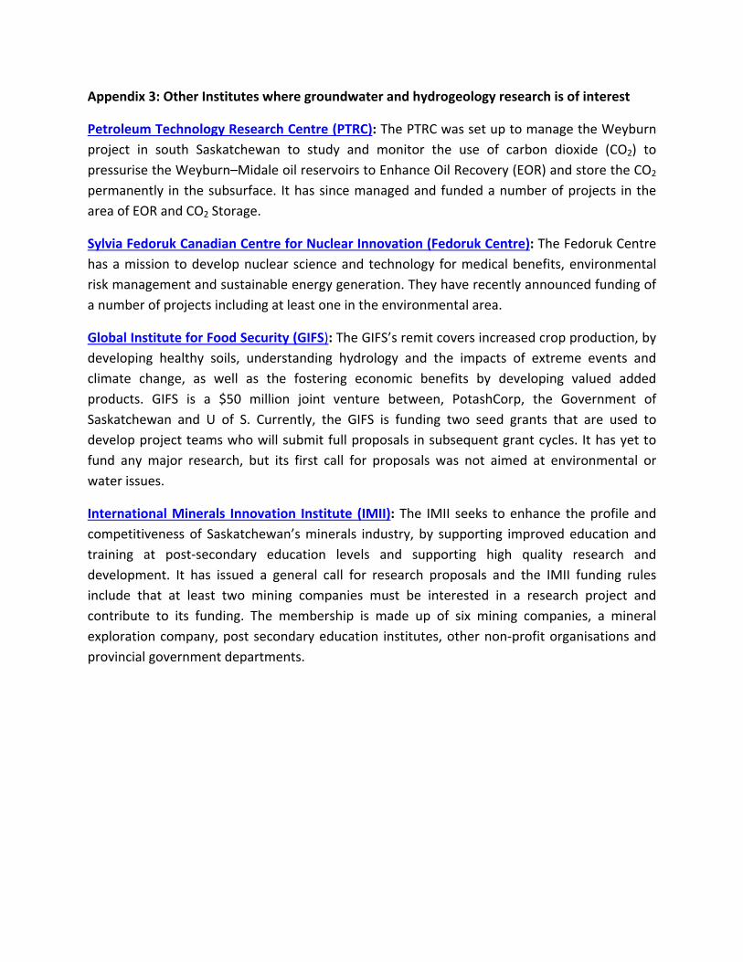
Appendix 3: Other Institutes where groundwater and hydrogeology research is of interest
Petroleum Technology Research Centre (PTRC): The PTRC was set up to manage the Weyburn
project in south Saskatchewan to study and monitor the use of carbon dioxide (CO2) to
pressurise the Weyburn–Midale oil reservoirs to Enhance Oil Recovery (EOR) and store the CO2
permanently in the subsurface. It has since managed and funded a number of projects in the
area of EOR and CO2 Storage.
Sylvia Fedoruk Canadian Centre for Nuclear Innovation (Fedoruk Centre): The Fedoruk Centre
has a mission to develop nuclear science and technology for medical benefits, environmental
risk management and sustainable energy generation. They have recently announced funding of
a number of projects including at least one in the environmental area.
Global Institute for Food Security (GIFS): The GIFS’s remit covers increased crop production, by
developing healthy soils, understanding hydrology and the impacts of extreme events and
climate change, as well as the fostering economic benefits by developing valued added
products. GIFS is a $50 million joint venture between, PotashCorp, the Government of
Saskatchewan and U of S. Currently, the GIFS is funding two seed grants that are used to
develop project teams who will submit full proposals in subsequent grant cycles. It has yet to
fund any major research, but its first call for proposals was not aimed at environmental or
water issues.
International Minerals Innovation Institute (IMII): The IMII seeks to enhance the profile and
competitiveness of Saskatchewan’s minerals industry, by supporting improved education and
training at post‐secondary education levels and supporting high quality research and
development. It has issued a general call for research proposals and the IMII funding rules
include that at least two mining companies must be interested in a research project and
contribute to its funding. The membership is made up of six mining companies, a mineral
exploration company, post secondary education institutes, other non‐profit organisations and
provincial government departments.
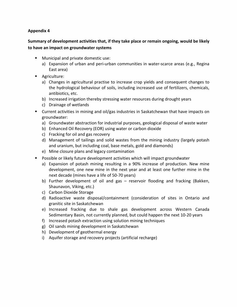
Appendix 4
Summary of development activities that, if they take place or remain ongoing, would be likely
to have an impact on groundwater systems
Municipal and private domestic use: a) Expansion of urban and peri‐urban communities in water‐scarce areas (e.g., Regina
East area)
Agriculture: a) Changes in agricultural practise to increase crop yields and consequent changes to
the hydrological behaviour of soils, including increased use of fertilizers, chemicals, antibiotics, etc.
b) Increased irrigation thereby stressing water resources during drought years c) Drainage of wetlands
Current activities in mining and oil/gas industries in Saskatchewan that have impacts on groundwater: a) Groundwater abstraction for industrial purposes, geological disposal of waste water b) Enhanced Oil Recovery (EOR) using water or carbon dioxide c) Fracking for oil and gas recovery d) Management of tailings and solid wastes from the mining industry (largely potash
and uranium, but including coal, base metals, gold and diamonds) e) Mine closure plans and legacy contamination
Possible or likely future development activities which will impact groundwater a) Expansion of potash mining resulting in a 90% increase of production. New mine
development, one new mine in the next year and at least one further mine in the next decade (mines have a life of 50‐70 years)
b) Further development of oil and gas – reservoir flooding and fracking (Bakken, Shaunavon, Viking, etc.)
c) Carbon Dioxide Storage d) Radioactive waste disposal/containment (consideration of sites in Ontario and
granitic site in Saskatchewan e) Increased fracking due to shale gas development across Western Canada
Sedimentary Basin, not currently planned, but could happen the next 10‐20 years f) Increased potash extraction using solution mining techniques g) Oil sands mining development in Saskatchewan h) Development of geothermal energy i) Aquifer storage and recovery projects (artificial recharge)
Appendix 5
Hydrogeology and Groundwater in Saskatchewan – a brief overview
It is beyond the scope of this report to provide a comprehensive description of the
hydrogeology of Saskatchewan, but it was considered important to provide an overview so that
the most important issues and knowledge gaps may be understood.
Overview of the hydrogeology of Saskatchewan
There has been considerable investment by government in the mapping of the geology of
Saskatchewan to support mineral and oil and gas development and to facillitate the
development of groundwater supplies. The Water Security Agency and its predessessors have
also developed an excellent database of hydrogeological maps which is currently being
updated. They have also presented information in their 2010 State of the Watershed Report
(Davies and Hanley, 2010). Recent and current work of Natural Resources Canada, in particular
on buried valley aquifers, is also important (Cummings, et al., 2012). Some studies into regional
impacts of carbon dioxide and other fluid injections into the Basal Cambrian aquifers have been
undertaken in the prairie provinces (e.g., Rebscher, et al., 2012) and further work involving the
Geological Survey of Saskatchewan is current. In addition to these major contributions, the
Saskatchewan Research Council has over that last few decades carried out considerable
research and data collection, as have many researchers in the university and government
sectors. In particular, the work of Christiansen on Quaternary stratigraphy (e.g., Christiansen
and Sauer, 2002), van der Kamp on many aspects of physical hydrogeology (e.g., van der Kamp,
1989; van der Kamp and Hayashi, 1998; van der Kamp and Maathuis, 2006; van der Kamp and
Maathuis, 2012), Hendry on aquitards and isotope hydrogeology (e.g., Hendry, 1988; Hendry, et
al., 2013), Maathuis on regional hydrogeology (e.g., Maathuis, 2005; Maathuis and Simpson,
2006; Maathuis and van der Kamp, 2011) and Hayashi on processes and other aspects (e.g.,
Hayashi, et al., 1998, van der Kamp and Hayashi, 2009) is undoubtedly world class and has
resulted in a firm base on which to build the future. In truth there is much known about the
hydrogeology of south Saskatchewan, but the current and likely future pace of development
will place new challenges before the hydrogeological science base, for both government and
industry.
The hydrogeology of southern Saskatchewan is dominated by the Western Canada Sedimentary
Basin (WCSB) and superficial deposits overlying the solid geology. Figure 1 shows the
distribution of Precambrian rocks in the north and the Phanerozoic rocks of the WCSB, to the
south. A summary of the major aquifers is given in the 2010 State of the Watershed Report,
Appendix A (Davies and Hanley, 2010).
Figure 2 shows the WCSB, which is of primary importance to the matters discussed in this
report. Figure 3 shows a simplified cross-section from southwest to northeast through the
sedimentary sequence, demonstrating the way the deposits thin and wedge out towards the
northeast in Saskatchewan. Table 1 lists the major formations and indicates whether their
lithologies include aquifers. The subsurface extent of the major aquifers is shown on Figure 4.
For the purposes of understanding the major likely research and management issues, the
succession given in Table 1 can be split into four groups.
a) The near-surface groundwater system that is often intimately connected to the prairie
pond systems. This system is not fully understood and although much research into
monitoring ponds, pond overflows and shallow piezometer levels close to the pond
systems has been carried out, this has not been tied into the shallow aquifer systems
which lie just a few metres below the base of the ponds. A description of current
understanding of prairie pond hydrology and their geochemical functioning can be found
in Toth, et al., 2009 and Nachshon, et al., 2013. Essentially the pond systems are
separated into many hundreds of very small (often much less 1 km2) internal drainage
basins. A considerable number of these wetlands have been drained by farmers to obtain
more useful farmland. The impact of this drainage on the behaviour of the hydrological
system, including groundwater recharge to regional aquifers requires further work (van
der Kamp and Hayashi, 1998). Understanding the roles of deep and shallow groundwater
systems will improve the hydrological conceptual framework for the management of
wetland ecosystems (van der Kamp and Hayashi, 2009). Much of southern Saskatchewan
is largely disconnected from the main surface water river systems such as the South
Saskatchewan River and other main rivers, and, although groundwater is likely to be
connected to the surface water drainage systems, the role of the shallow aquifers is
uncertain. Recharge processes to the uppermost aquifers, which are extensively used in
rural areas for domestic supply and by farmers for livestock, yard washing and other
farming activities, are largely unquantified from observation and experimentation and
have not been numerically modelled with any confidence. The sustainability of these
shallow aquifers and their role in sustaining pond hydrology may be rather site specific
but remains uncertain.
b) Beneath this upper 5-20 metres there are many glacially-deposited aquifers of the
Quaternary. These are inter-bedded with thick and very poorly permeable till deposits,
where interstitial water has in some cases been shown to be many thousands of years
old (Hendry, 1988; Shaw and Hendry, 1998). These aquifers tend to be discontinuous and
of very variable thickness and hydraulic conductivity. Understanding flow and resource
availability in these discontinuous Quaternary and Tertiary units is a major challenge.
They provide water supplies to many small towns and communities, for example Yorkton
(Maathuis and Simpson, 2006). Water quality is highly variable with Total Dissolved
Solids (TDS) up to 1500mg/l (Thompson, 2003). The dissolved salts are usually largely
made up of sulphates derived from the surrounding tills. Water quality data from the
Water Security Agency’s Rural Water Quality Database indicate that as many as 10% of
wells sampled have selenium levels above the Maximum Admissible Concentration
(MAC) and over 4% have arsenic levels about the Interim MAC (Olkowski, 2009). It also
seems that there is limited data available on the biological quality of groundwaters used
for private domestic supply. The morphology of these aquifers requires more attention,
their lateral heterogeneity and continuity are often unknown and their interrelationships
with other aquifers not well understood. Their yields are usually low to moderate, but
they are often the only sources of reasonably fresh water to be found in rural regions
away from the main river basins. The areal variation in water quality is often poorly
known. For example, in order to provide water supplies to the developing area to the
east of Regina the Zehner and Condie aquifers (see Table 2) need to be exploited, so a
good estimate of their reliable yield is essential. Although there is an estimate of reliable
yield (4,800dam3/year) from the Zehner aquifer, more refinement of the sustainable
yield is required prior to further development (pers. com. K. Lo, Saskatchewan Water
Security Agency). The relationships between groundwater in these aquifers and surface
waters in some areas are unknown, there is an apparent hydraulic barrier within the
Zehner aquifer whose extent is unknown, uncertainty in the area of recharge and lateral
and vertical variations in hydraulic parameters are not well understood. The impacts of
current long-term abstractions cannot be predicted reliably because of a lack of long-
term monitoring. This example has been chosen to illustrate the hydrogeological
knowledge gaps that emerge when sustainable development of groundwater resources
is required. The regulator must allocate water resources on a sustainable basis whilst
protecting the environment. Pollution of the Condie aquifer from surface leakage in the
past resulted in a contaminant plume over 7 km long (van der Kamp et al., 1994),
considerably restricting its use for domestic purposes. The plume was the result of
leakage of effluent from a disposal reservoir used by a water softening plant.
c) As can be seen from Tables 1 and 2, the Quaternary overlies older bedrock, including
aquifers of the Tertiary and Cretaceous clastic deposits. The Empress Group (see Table 2)
consists of cross-cutting buried valley sands and gravels. Prairie buried-valley fills
commonly function as aquifers that yield abundant groundwater. These aquifers can be
many metres thick and infill valleys of a Tertiary and early Pleistocene drainage system.
These deposits can form major aquifers that run longitudinally for several hundred
kilometres. Examples are the Hatfield Valley aquifer, the Estevan Valley aquifer and the
Swift Current Valley aquifer. They have distinct morphologies and a distinct stratigraphic
setting, which imparts them with distinct hydrogeological properties. Although there has
been considerable study of their geology and hydrogeology (Cummings et al., 2012),
their distribution and the detail of their morphology is less well known, and the
hydrogeological interactions with Quaternary aquifers or deeper aquifers like those of
the Bearpaw formation or the Judith River aquifer are very uncertain. Natural Resources
Canada (NRCan) have recently completed a pilot project researching these buried valley
aquifers, which might be taken further in the areas where demand for groundwater is
growing, see Figure 5 (Cummings et al., 2012) These buried valleys are known to cut
deeply into Bearpaw and Judith River aquifers, both of which are used for supply
purposes (Slawinski and Glen, 1987; Cummings et al., 2012). Little modelling of these
various interactions has been carried out and the origins of recharge to these aquifers is
often uncertain, as in the case of the Estevan aquifer which suffered over-pumping in the
late 1980s and early 1990s (van der Kamp and Maathuis, 2012). The Estevan Valley
aquifer is a buried valley, 2 – 4 km wide, up to 80 m thick and at least 70 km long. It is
confined by a 60 – 80 m thick aquitard composed mainly of glacial till. From September
1988 to May 1994 it was pumped at an annual rate of 3,750,000 m3. Long-term
observation well data show that the sustainable yield of the aquifer is significantly less
than 2,800 dam3/year (Maathuis and van der Kamp, 2011) and full recovery of the
groundwater level seems to be still many years away. The sustainable yield of the aquifer
has been revised downwards twice in the last 20 years as recovery has taken so long.
d) There are deep saline aquifers found below the Judith River aquifer. These formations
have never been used to supply potable water, but are sometimes used for oil and gas
operations and as fracking water. They are extensively used for the disposal of saline
brines from oil and gas extraction or potash mining and processing. The most commonly
used aquifers are the deep Cambro-Ordovician Winnipeg and Deadwood aquifers. These
are often used by both industries. The Ordovician, Silurian, Devonian, Carboniferous and
Permian deposits are, for the most part, composed of a very thick sequence of
carbonates and evaporites, within which lies the Prairie Evaporite Formation which
contains the valuable Potash deposits. In Potash mines, problems of water inflow are
caused by the mine galleries intersecting collapse structures in the evaporites.
Sometimes these are dry, but often they are connected to groundwater flow systems
which cause flooding and sometimes mine closure, and so are of great concern to the
mining industry. In this respect, knowledge of connection to underlying or overlying
aquifer systems is of huge importance. If, of course, the excess brine needs to be
injected, then mining engineers are clearly concerned that this process should not
endanger the mine or mining activity, so it is injected usually much deeper than the
mining levels. Some mining takes place by solution from water injected in boreholes and
shafts and pumped out having dissolved the potash minerals. This produces much more
water for disposal than conventional mining. The Aquistore CO2 storage project will inject
supercritical CO2 into the Cambro-Ordovician flow unit within the Williston Basin that is
comprised of the Deadwood Formation and Black Island member of the Winnipeg
Formation. These formations are also used for similar purposes by the oil and gas
industry and the potash mining industry. The storage of radioactive waste would appear
to be focussed on hard granitic environments in the Canadian Shield, but would clearly
have to satisfy very long-term and stringent safety criteria which would include
understanding the groundwater environment. The development of geothermal energy
would clearly focus on the deeper deposits discussed above and would focus on high
thermal gradients in the aquifers at depth. Aquifer storage and recovery was considered
in the past and not taken forward, but could be in future years, for storage of excess
flows for retrieval during times of drought. All of these activities that are developing the
energy and mineral resources of Saskatchewan require the drilling of deep boreholes. In
2012 an estimated 29,600 wells produced 172.9 million barrels of oil. These wells all
penetrate through potable aquifers and are properly sealed, but wells have been drilled
since the 1950s. The sealing of these legacy wells is fundamental to the protection of one
aquifer from ingress of groundwater from another, in areas where fracking is being
carried out (Jackson and Desseault, 2013). These old wells may represent the weakest
links between aquifers, especially since high pressures will be brought to bear on the
deep aquifers as CO2 storage become a reality.
There are some broad conclusions that can be drawn from this appreciation of the
hydrogeology, its complexity and the current economic, social and science drivers outlined
above.
1. Greater competition for water supplies for industrial and agricultural purposes is likely to result in a greater demand on groundwater. It is currently unknown if domestic or municipal or industrial supplies can be made available for long-term or emergency use (e.g., in the event of very severe droughts). Long-term sustainability is implemented through adaptive management of the groundwater resources so allocation and regulation requires long-term monitoring. Recharge is largely unquantified, whether directly from rainfall or indirectly from surface water. The dynamics of storage replenishment are uncertain, as demonstrated by the Estevan Valley aquifer’s slow recovery, but in other aquifers the flow regimes may be quite different.
2. Greater competition will occur for the use of geological pore space, for the disposal of contaminated brines and CO2 from a variety of sources. The long-term impacts on the subsurface and the connection to the surface and to mines and to other fresher groundwater resources are currently unknown.
3. There is a significant possibility of activities, such as adjacent mines or CO2 storage and oil process water disposal, interacting, resulting in derogations and other unforeseen consequences. These could include pollution and contamination of resources that once contaminated would never be able to be cleaned up economically.
4. Investments that are currently being made in the oil and gas and mining industries are very large. To make these investments, which secure the economic future of Saskatchewan and have an important positive economic boost for all Canada, investors need to have confidence that the province is making sound regulatory decisions, based on the best science and evidence available.
There are some other issues not yet touched upon that are pertinent to raise at this point: 1. It is clear that although much knowledge lies with government, much also lies with
industry. Both oil and gas and the potash industry will undoubtedly have much data on
disposal of brines and water resources contingency planning which may not be in the
public domain. Investigations into water resource availability are made for these
companies to assure themselves that their investments are made with the lowest
possible risk, but these are also not generally in the public domain. Many of the mining
and oil and gas companies have contracted consultants to investigate and model their
development and impacts of their activities to reduce their risks, and hence much
relevant knowledge lies within the consultancy sector, but is not generally publicly
available.
2. Provincial responsibilities for subsurface regulation and management of groundwater
and groundwater quality are divided between several Ministries and Agencies. These
include the Ministry of Environment, Ministry of Health, Ministry of Economy, and most
importantly the Water Security Agency. This is not uncommon in other jurisdictions, but
it does mean that coordination of research, data and information must be strongly
pursued to produce the best results and decisions. Some of the aquifers (both supply
and those used for waste disposal), cross national boundaries (Canada-USA), and
therefore activities in one country may affect or impact on the groundwater
environment in the other.
3. Although there is a growing cadre of excellent scientists that work in the groundwater
and hydrogeological disciplines, much of the groundwater knowledge and experience
for Saskatchewan lies with a few very experienced hydrogeologists who are retired or
close to retirement. Once they have gone, a great deal of knowledge will be lost. Much
of this knowledge is currently not in the public domain (i.e., not published but found in
restricted grey literature).
4. There is no coordinated programme of scientific research across the
hydrogeological/groundwater domain that seeks to fill knowledge gaps.
5. The long term impacts of current and future use of geological pore space for waste
disposal are largely unknown and unpredicted. This may sometimes be simply a
business risk issue, but it also poses issues of environmental protection and
sustainability.
6. Long-term water security issues that may require greater use of groundwater cannot be
addressed, without understanding:
a) The interactions between the various aquifer units,
b) The 3D morphology and structure of these units,
c) The heterogeneity of lithology and physical parameters displayed by these aquifers,
d) The recharge, if any, to these aquifer deposits,
e) The integrity and vulnerability of cap rocks, and
f) The degree of knowledge necessary will depend upon the size of the demands for
resources and/or the scale of other activities in the subsurface.
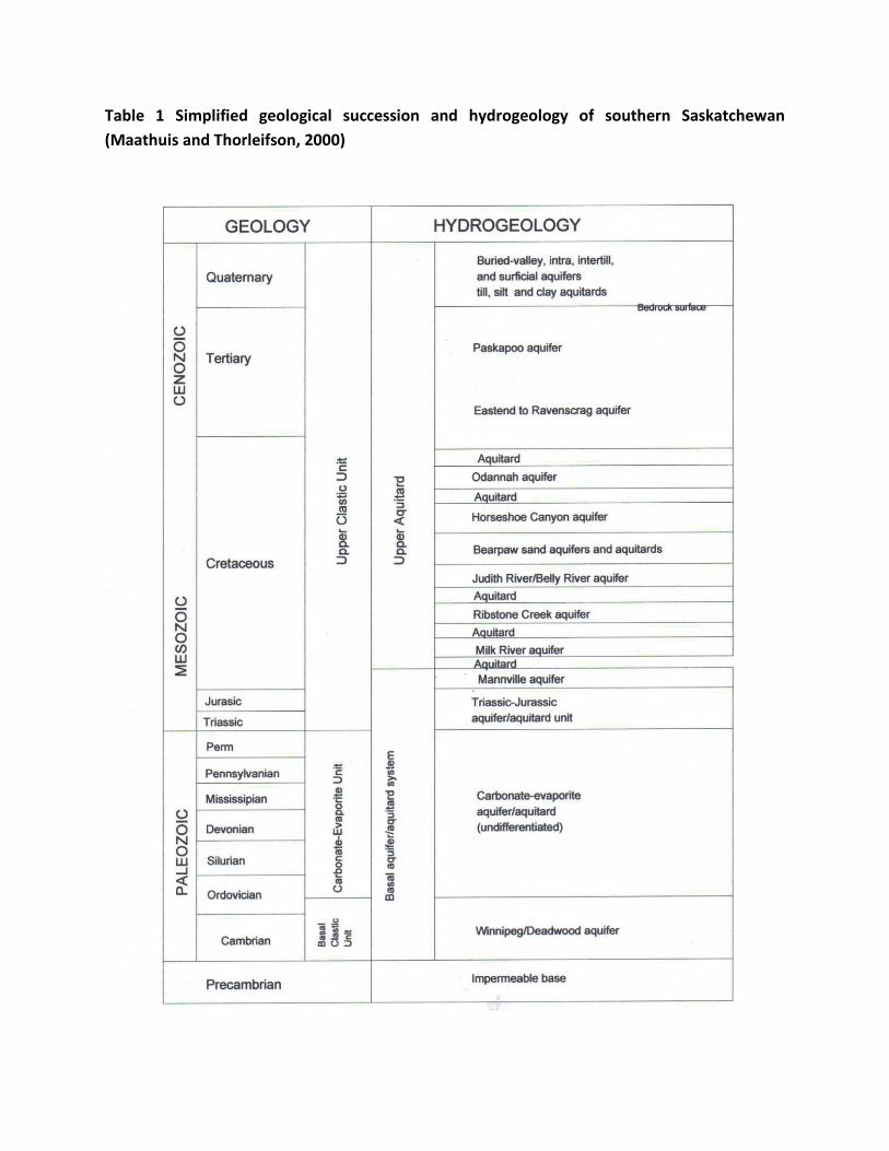
Table 1 Simplified geological succession and hydrogeology of southern Saskatchewan
(Maathuis and Thorleifson, 2000)
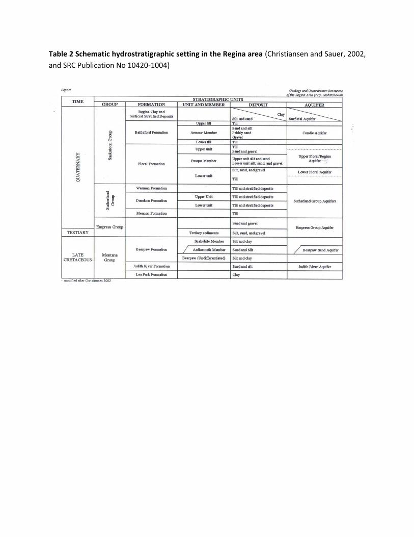
Table 2 Schematic hydrostratigraphic setting in the Regina area (Christiansen and Sauer, 2002,
and SRC Publication No 10420-1004)
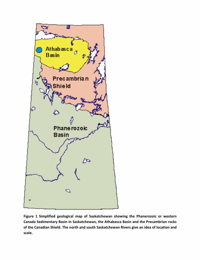
Figure 1 Simplified geological map of Saskatchewan showing the Phanerozoic or western
Canada Sedimentary Basin in Saskatchewan, the Athabasca Basin and the Precambrian rocks
of the Canadian Shield. The north and south Saskatchewan Rivers give an idea of location and
scale.
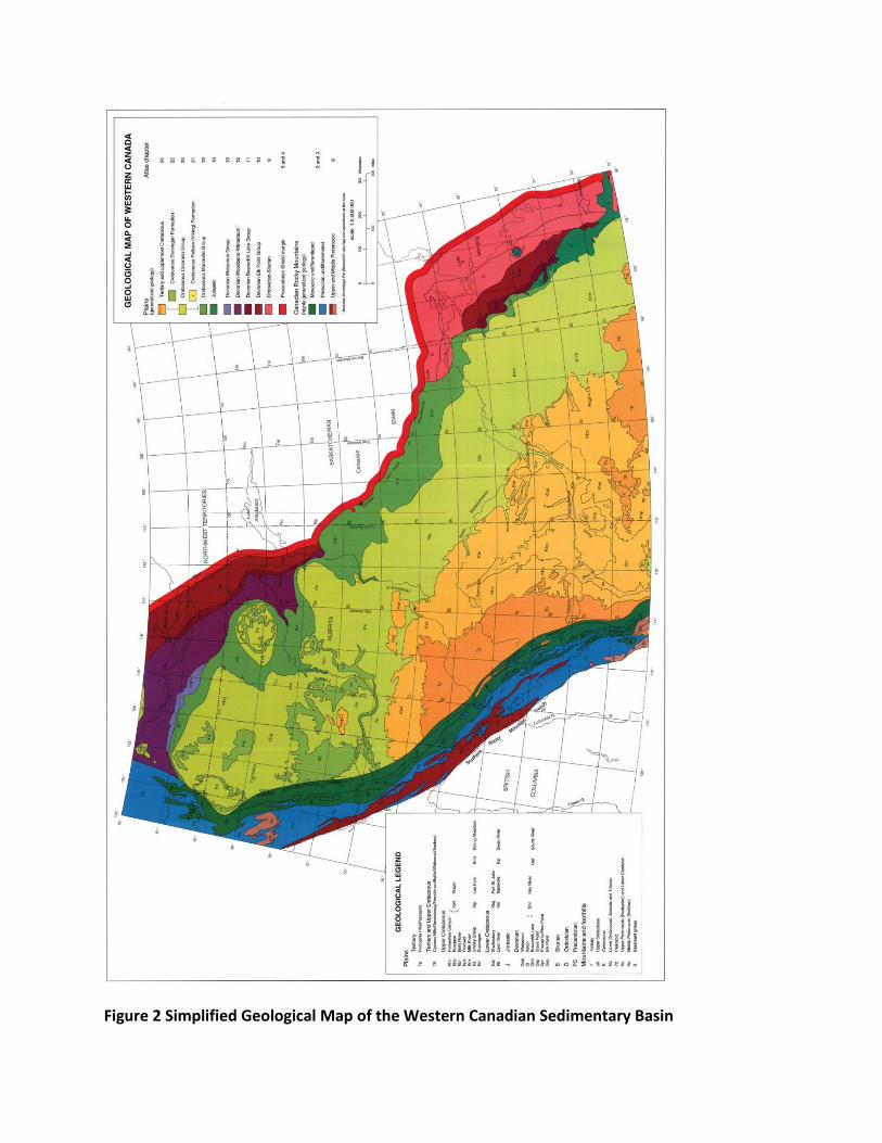
Figure 2 Simplified Geological Map of the Western Canadian Sedimentary Basin
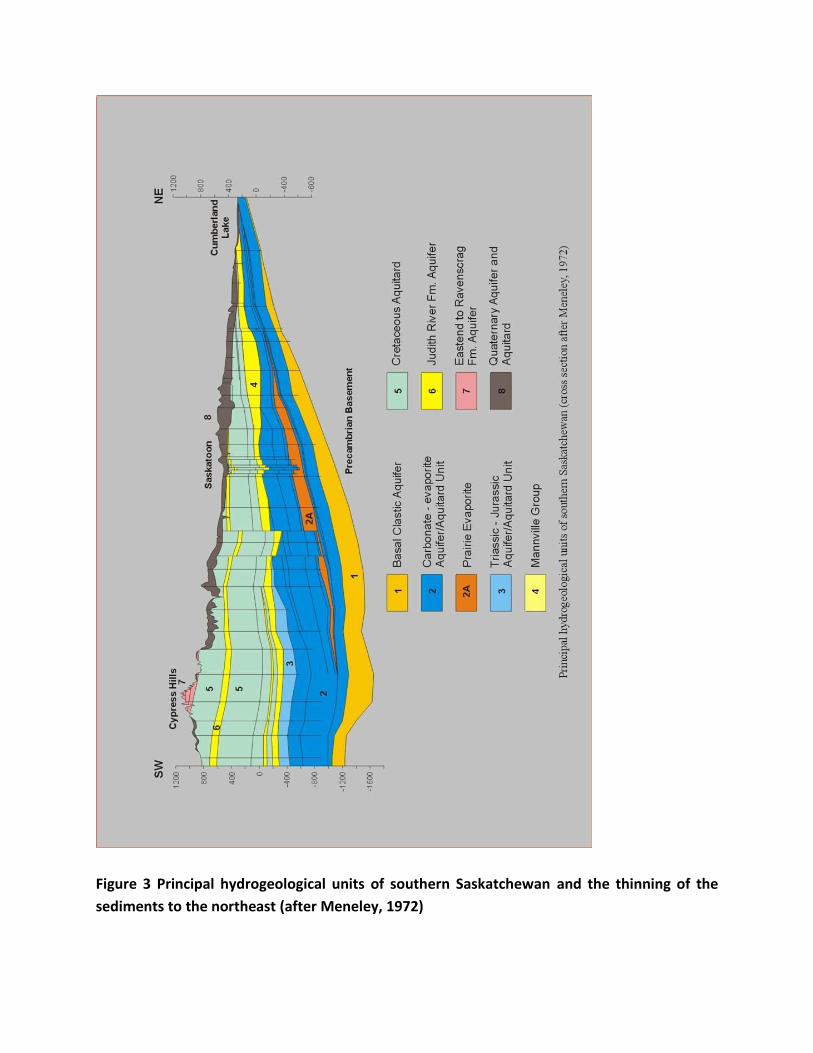
Figure 3 Principal hydrogeological units of southern Saskatchewan and the thinning of the
sediments to the northeast (after Meneley, 1972)
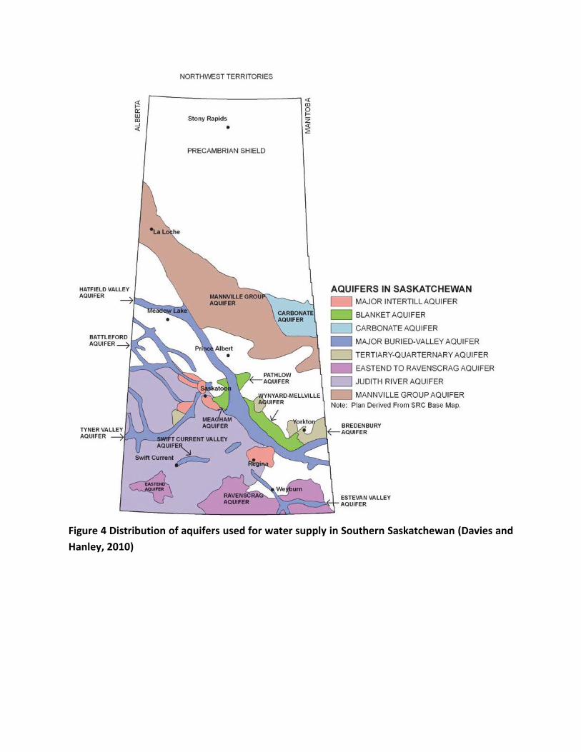
Figure 4 Distribution of aquifers used for water supply in Southern Saskatchewan (Davies and
Hanley, 2010)
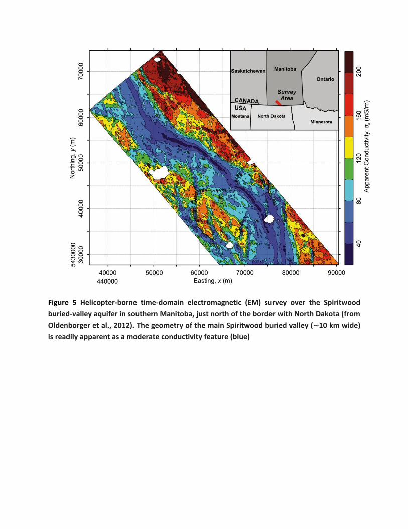
Figure 5 Helicopter-borne time-domain electromagnetic (EM) survey over the Spiritwood
buried-valley aquifer in southern Manitoba, just north of the border with North Dakota (from
Oldenborger et al., 2012). The geometry of the main Spiritwood buried valley (∼10 km wide)
is readily apparent as a moderate conductivity feature (blue)
Appendix 6 References and documents consulted
References cited in the text of main report and Appendix 5
Alberta Environment Monitoring Panel. 2011. A World Class Environmental Monitoring, Evaluation and Reporting System for Alberta: The Report of the Alberta Environment Monitoring Panel. June. 102pp.
Bonsal, B. and Wheaton, E. 2005. Atmospheric circulation comparison between 2001 and 2002 and the 1961 and 1988 Canadian prairie droughts. Atmosphere‐Ocean, 43(2): 163–172.
Bonsal, B., Aider, R., Gachon, P. and Lapp, S. 2013. An assessment of Canadian prairie drought: past, present and future. Climate Dynamics, 41: 501‐516.
Christiansen, E.A. and Sauer, K.E. 2002. Stratigraphy and structure of the Pleistocene collapse in the Regina Low, Saskatchewan. Canadian Journal of Earth Sciences, 30(9): 1411‐1423.
Clifton Associates Ltd. 2008. The Economic, Social and Environmental Benefits of Expanding Irrigation in Saskatchewan. Report produced for Saskatchewan Irrigation Products Association, 140pp.
Council of Canadian Academies. 2013. Water and Agriculture in Canada: Towards Sustainable Management of Water Resources. The Expert Panel on Sustainable Management of Water in the Agricultural Landscapes of Canada, Council of Canadian Academies, 259pp.
Cummings, D.I., Russell, H.A. and Sharpe, D.R. 2012. Buried‐valley aquifers in the Canadian Prairies: geology, hydrogeology, and origin 1 1 Earth Science Sector (ESS) Contribution 20120131. Canadian Journal of Earth Sciences, 49(9): 987‐1004.
Davies, H. and Hanley, P.T. 2010. 2010 State of the Watershed Report. Saskatchewan Watershed Authority. 39pp. plus three appendices and references.
Delphi Group. 2013. Scoping of a Water Management Plan – Crescent Point Energy Group.
Gan, T.Y. 2000. Reducing vulnerability of water resources of Canadian prairies to potential droughts and possible climatic warming. Water Resources Management, 14(2): 111‐135.
Government of Saskatchewan. 2003. State of the Environment Report ‐ A Provincial Perspective.
Government of Saskatchewan. 2012. Plan for Growth – a 2020 vision and beyond.
Government of Saskatchewan. 2013a. Saskatchewan Exploration and Development Highlights, Ministry of Economy, Saskatchewan Geological Survey. 14pp. http://economy.gov.sk.ca/SEDH2013.
Government of Saskatchewan. 2013b. Oil and Gas Facts sheets, ‐ Oil and Gas, Active oil plays, Oil and Gas Opportunities, Carbon Capture and Storage. http://economy.gov.sk.ca/Sask‐PNG‐Industry‐Facts.
Government of Saskatchewan. 2014. Minister’s Message, Agriview, Issue 09. Volume 9. February 2014. http://www.agriculture.gov.sk.ca/agriview.
Hanesiak, J.M., Stewart, R.E., Bonsal, B.R., Harder, P., Lawford, R., Aider, R. and Zha, T. 2011. Characterization and summary of the 1999–2005 Canadian Prairie drought. Atmosphere‐Ocean, 49(4): 421‐452.
Hayashi, M., van der Kamp, G. and Rudolph, D.L. 1998a. Water and solute transfer between a prairie wetland and adjacent uplands, 1. Water balance. Journal of Hydrology, 207(1): 42‐55.
Hayashi, M., van der Kamp, G. and Rudolph, D.L. 1998b. Water and solute transfer between a prairie wetland and adjacent uplands, 2. Chloride cycle. Journal of Hydrology, 207(1): 56‐67.
Hendry, M.J. 1988. Hydrogeology of clay till in a prairie region of Canada. Ground Water, 26(5): 607‐614.
Hendry, M.J., Barbour, S.L., Novakowski, K. and Wassenaar, L.I. 2013. Paleohydrogeology of the Cretaceous sediments of the Williston Basin using stable isotopes of water, Water Resources Research, 49: doi:10.1002/wrcr.20321.
Hitchon B, editor. 2012. Best Practices for Validating CO2 Geological Storage: Observations and Guidance from the IEAGHG Weyburn‐Midale CO2 Monitoring and Storage Project. Sherwood Park, AB: Geoscience Publishing.
http://economy.gov.sk.ca/OilGas. Ministry of Economy, Saskatchewan Geological Survey website.
http://aquistore.ca/. Aquistore website.
http://www.ppwb.ca/information/106/index.html, 2009. Prairie Provinces Water Board website.
http://www.nwmo.ca/dgrsubmission Nuclear Waste Management Organisation website DGR submission
Jackson, R. and Desseault, M. 2013. Abstract: Seepage Pathway Assessment for Natural Gas to Shallow Groundwater during Well Stimulation, Production, and after Abandonment, Geo Montreal, 2013.
Kulshreshtha, S., Nagy, C. and Bogdan, A. 2012. Present and Future Water Demand in Selected Saskatchewan River Basins, University of Saskatchewan, report prepared for Saskatchewan Watershed Authority, 294pp. plus appendices.
Laniak, G.F., Olchin, G., Goodall, J., Voinov, A., Hill, M., Glynn, P., Whelan, G., Geller, G., Quinn, N., Blind, M., Peckham, S., Reaney, S., Gaber, N., Kennedy, R. and Hughes, A. 2013. Integrated environmental modeling : a vision and roadmap for the future. Environmental Modelling & Software, 39: 3‐23. doi: 10.1016/j.envsoft.2012.09.006.
Lawford, R.G. 1992. Research Implications of the 1988 Canadian Prairie Provinces Drought. Natural Hazards, 6: 109‐129.
Maathuis, H. and Thorleifson, L.H. 2000. Potential impact of climate change on prairie groundwater supplies: review of current knowledge. Saskatchewan Research Council Publication No. 11304‐2E00.
Maathuis, H. 2005. Review of Pumping and Recovery Data for the Tyner Valley Aquifer and Impact of Pumping on the Tessier Aquifer Saskatchewan Research Council, SRC publication No. 10417‐2E05.
Maathuis, H. and Simpson, M. 2006. Groundwater Resources in the Yorkton Aquifer Management Plan Area Final Report. Saskatchewan Research Council, Publication 10419‐1E06.
Maathuis, H. and van der Kamp, G., 2011. Predictions, observations and analysis of the drawdown and recovery for the Estevan Valley Aquifer due to 6 years of pumping. Geohydro 2011.
Meneley, W.A. 1972. Groundwater, Saskatchewan. Water Supply for the Saskatchewan‐Nelson Basin: Saskatchewan‐Nelson Basin Board Report. App, 7, 673‐723.
Moore, R., Hughes, A., Gaber, N., Geller, G., Glynn, P., Laniak, G., Voinov, A., and Whelan, G. 2012. International Summit on Integrated Environmental Modeling. US Environmental Protection Agency, 62pp. (OR/12/087) (Unpublished).
Nachshon, U., Ireson, A., van der Kamp, G. and Wheater, H. 2013. Sulfate salt dynamics in the glaciated plains of North America. Journal of Hydrology, 499: 188‐199.
Nuclear Waste Management Organisation. 2013. Phase 1 Preliminary Assessments – Summary Findings and Decisions.
NRCan ‐‐ Natural Resources Canada. 2010. The Atlas of Canada. On‐Line. Accessed in June 11, 2012 at: http://atlas.nrcan.gc.ca/site/english/learningresources/facts/rivers.htm.
Oldenborger, G.A., Pugin, A.M. and Pullan, S.E. 2012. Airborne Time‐Domain Electromagnetics for Three Dimensional Mapping and Characterization of the Spiritwood Valley Aquifer. In 25th Symposium on the Application of Geophysics to Engineering & Environmental Problems.
Olkowski, A.A. 2009. Livestock Water Quality – a field guide for cattle, horses, poultry and swine. Ministry of Agriculture and Agri‐Food, Canada.
Rebscher, D., Zhon, Q. and Birkholzer, J.T. 2012. Simulation of CO2 Storage in the Basal Aquifer in the Northern Plains – Prairie Region of North America, Proceedings – Tough Symposium 2012, Lawrence Berkeley National Laboratory, Berkeley, California, September 17‐19, 2012.
Rutherford, S. 2004. Groundwater use in Canada, West Coast Environmental Law.
Shaw, R.J. and Hendry, M.J. 1998. Hydrogeology of a thick clay till and Cretaceous clay sequence, Saskatchewan, Canada. Canadian Geotechnical Journal, 35(6): 1041‐1052.
Slawinski, A. and Glen, P. 1987. Swift Current Valley: A Glacially Disrupted Buried‐Valley Aquifer System. Proceedings of the NWWA FOCUS Conference on Northwestern Ground Water Issues. National Water Well Association, Dublin OH., p. 179‐201. 43 ref.
Statistics Canada. 2012. Focus on Geography Series, 2011 Census. Statistics Catalogue no. 98‐310‐XWE20111004. Ottawa, Ontario. Analytical products.2011 Census.
Statistics Canada. 2013. CANSIM Table 379‐0030, http://www5.statcan.gc.ca/cansim/.
Thompson, T.S., Le, M.D., Kasick, A.R. and Macaulay, T.J. 1999. Arsenic in well water supplies in Saskatchewan. Bulletin of environmental contamination and toxicology, 63(4): 478‐483.
Thompson, T.S. 2001. Nitrate concentrations in rural domestic drinking water supplies in Saskatchewan, Canada. Bulletin of environmental contamination and toxicology, 66: 64‐70.
Thompson, T.S. 2003. General chemical water quality of private groundwater supplies in Saskatchewan, Canada. Bulletin of environmental contamination and toxicology, 70(3): 0447‐0454.
Toth, B., Corkal, D.R., Sauchyn, D., van der Kamp, G. and Pietroniro, E. 2009. The natural characteristics of the South Saskatchewan River Basin: Climate, geography and hydrology. In Prairie Forum, 34(1): 95‐127.
van der Kamp, G. 1989. Calculation of Constant‐Rate Drawdowns from Stepped‐Rate Pumping Tests. Ground Water, 27(2): 175‐183.
van der Kamp, G., Luba, L.D., Cherry, J.A. and Maathuis, H. 1994. Field study of a long and very narrow contaminant plume. Ground Water, 32(6): 1008‐1016.
van der Kamp, G. and Hayashi, M. 1998. The groundwater recharge function of small wetlands in the semi‐arid northern prairies. Great Plains Research, 8: 39‐56.
van der Kamp, G. and Maathuis, H. 2006. Groundwater sustainability in the prairies–some examples. In Proceedings of the IAH‐CNC Conference, Vancouver, BC, October (pp. 1‐4).
van der Kamp, G. and Hayashi, M. 2009. Groundwater‐wetland ecosystem interaction in the semiarid glaciated plains of North America. Hydrogeology Journal, 17(1): 203‐214.
van der Kamp, G. and Maathuis, H. 2012. The Unusual and Large Drawdown Response of Buried‐Valley Aquifers to Pumping. Ground Water, 50(2): 207‐215. Documents consulted
Abstracts. 2010. Workshop on Buried Valley Aquifers, Saskatoon, 20 pp.
Advanced Resources International. 2013. EIA/ARI World Shale Gas and Shale Oil Resource Assessment. Chapter 1, Canada. 1‐133.
Betcher, R., Grove, G. and Pupp, C. 1995. Groundwater in Manitoba; Hydrogeology, Quality concerns, Management NHRI Contribution Number CS‐93017.
Bezys, R.K., Beauchamp, B., Kreis, L.K., Martiniuk, C.D., Nicolas, M. and Whittaker, S. 2004: Targeted Geoscience Initiative II – Williston Basin architecture and hydrocarbon potential in southwestern Manitoba and southeastern Saskatchewan: an update; in Report of Activities 2004, Manitoba Industry, Economic Development and Mines, Manitoba Geological Survey, 262–265.
Canadian Association of Petroleum Producers. 2010. Responsible Water Management in Canada’s Oil and Gas Industry.
Canadian Association of Petroleum Producers. 2011. About Canada’s Oil Sands.
Charrois, J.W.A. 2010. Private drinking water supplies: challenges for public health. Canadian Medical Association Journal, 182(10): 1061‐1064.
Christiansen, E.A. and Schmid, B.J. 2009. The Glacial Geology of Southern Saskatchewan. The Geological Survey of Canada.
Corkal, D., Schutzman, W.C. and Hilliard, C.R. 2003. Rural water safety from the source to the on‐farm tap, Journal of Toxicology and Environmental Health, Part A: Current Issues, 67(20‐22): 1619‐1642.
Council of Canadian Academies. Expert Panel on Groundwater. 2009. The Sustainable Management of Groundwater in Canada. Council of Canadian Academies.
Crowe, A.S., Schaefer, K.A., Kohut, A., Shikaze, S.G. and Ptacek, C.J. 2003. Groundwater Quality. Canadian Council of Ministers of the Environment, Winnipeg, Manitoba. CCME Linking Water Science to Policy Workshop Series. Report No. 2, 52pp.
Digney, J.E. and Gillies, J.A. 1995. Artificial Recharge in Saskatchewan: Current Developments. Journal of the American Water Resources Association, 31(1): 33‐42.
Devito, K., Mendoza, C. and Qualizza, C. 2012. Conceptualizing water movement in the Boreal Plains. Implications for watershed reconstruction. Synthesis report prepared for the Canadian Oil Sands Network for Research and Development, Environmental and Reclamation Research Group. 164pp.
Cenovus TL ULC. 2011.Telephone Lake Project Volume 2 – Environmental Impact Assessment, Section 6 – Geology and Hydrogeology.
Dissanayake, N.L. 2008. Modelling the impact of total stress changes on groundwater flow. MSc Dissertation, University of Saskatchewan.
Ferguson, G. and Lindsay, M. 2013. Hydrogeological Research for Saskatchewan's Potash Industry. Research EOI to IMII.
Ferguson, G. 2013. Subsurface energy footprints. Environmental Research Letters, 8(1): 014037.
Ferguson, G., Ireson, A.M. and Lindsay, M. 2013. Probabilistic risk assessment of groundwater flow and contaminant transport. Submitted project proposal.
Genzwill, D. and Stauffer, M. 2006. Shallow faults, upper Cretaceous clinoforms, and the Colonsay Collapse, Saskatchewan. Canadian Journal of Earth Sciences, 43: 1859‐1875.
Government of Saskatchewan. 2012. Economic Review 2012 number 66. 46pp.
Hayashi, M. and van der Kamp, G. 2009. Progress in Scientific Studies of Groundwater in the Hydrologic Cycle in Canada, 2003‐2007. Canadian Water Resources Journal, 34(2): 177‐186.
Heagle, D.J., Hayashi, M. and van der Kamp, G. 2007. Use of solute mass balance to quantify geochemical processes in a prairie recharge wetland. Wetlands, 27(4): 806‐818.
Heagle, D., Hayashi, M. and van der Kamp, G. 2013. Surface–subsurface salinity distribution and exchange in a closed‐basin prairie wetland. Journal of Hydrology, 478: 1‐14.
Ireson, A.M., van der Kamp, G., Ferguson, G., Nachshon, U. and Wheater, H. S. 2013. Hydrogeological processes in seasonally frozen northern latitudes: understanding, gaps and challenges. Hydrogeology Journal, 21(1): 53‐66.
Johnson, M., Davidson, J. and Mortensen, P. 2009. A perspective on Canadian shale gas. Derived from: National Energy Board, 2009. A primer for understanding Canadian shale gas.
Kelly, L.I. and Holmden, C. 2001. Semi‐quantitative assessment of groundwater flux from H, O, and Sr isotopes, Lydden Lake sodium sulphate deposit, Saskatchewan. In summary of investigations 2001, Vol 2, Saskatchewan Geological Survey, Sask. Energy Mines Misc. Rep. 2001 ‐4.2.
Lennox, D.H., Maathuis, H. and Pederson, D. 1988. Region 13, Western glaciated plains. Hydrogeology. The Geological Society of North America, Boulder Colorado. 1988. p. 115‐128. 6 fig, 75 ref.
Lui, G., Widger, R.A. and Jin, J.C. 2006. Trend Analysis of Road Salt Impacts on Groundwater Salinity at a Long‐term Monitoring Site Paper prepared for presentation at the Success in Road Salt Management Session of the 2006 Annual Conference of the Transportation Association of Canada
Maathuis, H. 2000. Review and comparison of regional groundwater quality data in Saskatchewan. Saskatchewan Research Council, SRC Publication No. 10417‐4C00.
Maathuis, H. and Simpson, M. 2007. Groundwater resources of the Swift Current (72J) area, Saskatchewan. Saskatchewan Research Council. SRC Publication No. 12178‐1E07.
Maathuis, H. Groundwater level observation networks in Canada. Poster.
Maathuis, H., Schreiner, B., Karvonen, A., Falman, J.F. and Shaheen, N. 2011. Regional geological and groundwater mapping in Saskatchewan: a historical perspective, Geohydro 2011.
MacDonnell, J. and Barbour, L. 2013. Centre for Reclaimed Mine Overlay Site Testing (CR‐MOST), Proposal to IMII.
Mance, E. A Land Owners Guide to Water Well Management.
Marin, S., van der Kamp, G., Pietroniro, A., Davison, B. and Toth, B. 2010. Use of geological weighing lysimeters to calibrate a distributed hydrological model for the simulation of land–atmosphere moisture exchange. Journal of Hydrology, 383(3): 179‐185.
Martz, D.J.F. 1983. Variations in resident appraisals of groundwater quality on Saskatchewan farms MSc dissertation, University of Saskatchewan.
Melnik, A. 2012. Regional Hydrogeology of Southwest Saskatchewan MSc Dissertation, University of Alberta.
Mollard, J.D. 1965. A Reconnaissance Appraisal of Ground‐Water Potential and Development in Saskatchewan, Canada. Ground Water, 3(1): 5‐11.
National Energy Board and Saskatchewan Ministry of Energy and Resources. 2008. Saskatchewan’s ultimate potential for conventional natural gas. Miscellaneous Report 2008‐8.
Palombi, D.D. and Rostron, B.J. 2006. Regional hydrochemistry of Lower Palaeozoic aquifers in the northern portion of the Williston Basin, Saskatchewan–Manitoba; in Gilboy, C.F. and Whittaker, S.G. (eds.), Saskatchewan and Northern Plains Oil & Gas Symposium 2006, Saskatchewan Geological Society Special Publication 19, p201‐209.
Palombi, D. and Rostron, B. 2007, October. Regional Hydrogeological Characterization in the Northeastern Margin of the Williston Basin, Saskatchewan‐Manitoba, Canada. In 2007 GSA Denver Annual Meeting.
Patience, J.E., Beaulieu, A.D. and Gillis, D.A. 2004. The impact of ground water high in sulfates on the growth performance, nutrient utilization, and tissue mineral levels of pigs housed under commercial conditions. Journal of Swine Health and Production, 12: 228‐235.
Pomeroy. J.W., Fang, X. and Williams, B. 2009. Impacts of Climate Change on Saskatchewan’s Water Resources. Centre for Hydrology Report No. 6, University of Saskatchewan.
Potter, G.R. 2004. History Matching and predictive modelling of TMA operations at a potash mine site in Saskatchewan. MSc Dissertation. University of Saskatchewan.
Rivera, A. 2005. How well do we understand groundwater in Canada – A Case Study. ESS contribution no. 2005030, Geological Survey of Canada.
Saskatchewan Chamber of Commerce, Environment Committee. 2012. Saskatchewan’s Water Management Strategy, Saskatchewan Chamber of Commerce Adopted 2012 Policy Resolution.
Saskatchewan Environment. 2012. Saskatchewan’s Drinking Water Quality Standards and Objectives (summarized).
Schramm, L., Kramers, J. and Isaacs, E. 2010. Saskatchewan's Place in the Canadian Oil Sands. Journal of Canadian Petroleum Technology, 49(11): 12‐21.
Shaheen, N. and Sketchell, J. 1998. Groundwater Chemistry Programme Pilot Project. Simpson, M. A. (2000) Geology and Hydrostratigraphy of the Wynyard (72P) area. SRC Pub No 10416 – 1C00.
Simpson, M.A. 2004. Geology and Groundwater Resources of the Regina Area, Saskatchewan Research Council Publication No 10420‐1004.
Tallin, J.E., Pufahl, D.E. and Barbour, S.L. 1990. Waste management schemes of potash mines in Saskatchewan. Canadian Journal of Civil Engineering, 17(4): 528‐542.
Uwiera, M. 1998. Numerical simulation of brine migration in the vicinity of a potash mine MSc Dissertation, University of Saskatchewan.
Unland, W. 1981. Impact of a Glacial Uranium Deposit on the Groundwater Quality at Key Lake, Saskatchewan (Canada). Studies in Environmental Science, 17: 593‐596.
Vonhof, J.A. 1975. Waste disposal problems near potash mines in Saskatchewan, Canada. Inland Waters Directorate, Environment Canada, Scientific Series.
Water Security Agency. 2012. 25 Year Water Security Plan.
Wheater, H. 2013. GEWEX SaskRB Progress Report 2011‐13. University of Saskatchewan, Global Institute for Water Security.
Wheater, H., Gober, P., Ireson, A., et al., 2013. Water Security for the Minerals Industry. Research EOI to IMII.
Whitaker, S.H. and Christiansen, E.A. 1972. The Empress Group in southern Saskatchewan. Canadian Journal of Earth Sciences, 9(4): 353‐360.
Websites Consulted
http://www.cbc.ca/news/business/bakken‐formation‐will‐it‐fuel‐canada‐s‐oil‐industry‐1.761789 News article on the Bakken oil reserves. CBC News
http://www.centreforenergy.com/FactsStats/Statistics.asp?Template=5,0 Statistics on Energy in Canada
http://economy.gov.sk.ca/SGS Saskatchewan Geological Survey, maps programmes etc.
http://www.nrcan.gc.ca/earth‐sciences NRCan website, water section
http://www.oilsandstoday.ca Oil sand information
http://www.saskmining.ca/uploads/general_files/24/sma‐fact‐sheets‐2012.pdf Mining Fact Sheets. Saskatchewan Mining Association
https://www.wsask.ca/Water‐Info Information on groundwater, programmes and mapping


![[Jeremy Rifkin] La Economia Del Hidrogeno the Hydr(BookFi.org)](https://img.pdfslide.us/doc/110x75/55cf881d55034664618d7b14/jeremy-rifkin-la-economia-del-hidrogeno-the-hydrbookfiorg.jpg)