Embed Size (px)
Citation preview

Ground-Water Resources of the Bryce Canyon
_ _
National Park Area, UtahWith a section on THE DRILLING OF A TEST WELL
GEOLOGICAL SURVEY WATER-SUPPLY PAPER 1475-M
^ Prepared in cooperation with the\ National Park Service,\ Department of the Interior

Ground-Water Resources of the Bryce Canyon National Park Area, UtahWith a section on THE DRILLING OF A TEST WELL
By I. WENDELL MARINE
HYDROLOGY OF THE PUBLIC DOMAIN
GEOLOGICAL SURVEY WATER-SUPPLY PAPER 1475-M
Prepared in cooperation with the National Park Service, Department of the Interior
UNITED STATES GOVERNMENT PRINTING OFFICE, WASHINGTON : 1963

UNITED STATES DEPARTMENT OF THE INTERIOR
STEW ART L. UDALL, Secretary
GEOLOGICAL SURVEY
Thomas B. Nolan, Director
For sale by the Superintendent of Documents, U.S. Government Printing Office Washington 25, D.C.

CONTENTS
PageAbstract--__-_-_-_----_--_-_---___________-_______________-______ 441Introduction._____________________________________________________ 442
Purpose and scope-_-_-----___________-_____________-_____-____ 442Location of the area___________________________________________ 442Previous investigations._________-_-_______-_-___-__-________--_ 444Personnel and acknowledgments.-----.-------------------------- 444
Geography _______________________________________________________ 444Water use____________________________________________________ 445
Geology __________________________________________________________ 450Stratigraphy. _________________________________________________ 450Structure. _----_-__________---________----________--___-__---_ 461
Water resources-__------_--__---___--_____--__------_-_---__-_---- 461Surface water-____-_-__--_____-_____________________-_-_-__-_- 461Springs____-______________________________ 462Ground water in alluvium. __-_-__________________..-_-____--_-_- 471
East Creek valley.--.------.-_________________________ 471Other alluvium-filled valleys..------------------------------ 475
Ground water in bedrock-______________________________________ 475Conclusions-______________________________________________________ 477Drilling of a test well_-_-_-_-----_-_--____------_-___---_-----_---_ 478References cited-_-__--_-___-_-______._____-__-___-____-_-____--__- 483Index...._-________._.__.________-___-_____.___.__.________ 485
ILLUSTRATIONS
[Plates 24-26 In pocket]
PLATE 24. Map of Bryce Canyon National Park area, Utah, showing physio graphic features and the location of springs and wells.
25. A, Map of East Creek valley showing area underlain by alluvium. B, North-south section of East Creek valley showing inferred maximum depth to bedrock and the position of the water table in May 1957.
26. Logs of the test well at Bryce Canyon National Park.
ni

IV CONTENTS
Page FIGURE 51. Number of visitors to Bryce Canyon National Park from 1929
to 1956 and range of possible future attendance __________ 44352. Annual precipitation and cumulative departure from normal
at Bryce Canyon National Park________________________ 44553. Water-supply developments of the Utah Parks Co. in East
Creek valley showing wells, a developed spring, the spring- collector sump, and the spring pumphouse_______________ 447
54. Hydrographs of two observation wells in the alluvium of EastCreek valley, April to September 1957__________________ 449
55. Geologic map of the northern part of Bryce Canyon NationalPark area___________________________________________ 460
56. Generalized east-west cross section through Merrill Ranch Spring showing the movement of ground water in relation to the occurrence of all fault line springs in the area_____- 466
57. Yellow Creek Spring and the Yellow Creek Wash seen fromParia View observation point-_________________________ 469
58. Selected schematic cross sections across East Creek valleyshowing approximate thickness of alluvium-_____________ 473
59. Schematic diagrams of saturated alluvium in parts of EastCreek valley, May 1957------------------------------- 474
60. Graph of the water level during pumping of the test well- _ _ _ 481
TABLES
PageTABLE 1. Tropic Ditch diversions of the Tropic and East Fork Irriga
tion Co_.________________--_______-__-__-_-_--____ 4462. Monthly p,umpage from Utah Parks Co. well field in East
Creek valley during 1957 and the net decline in water level each month in well 3______-___-_______-_---___-_______ 448
3. Summary of quantities of water available from selected sources compared to present water use and estimated future water needs in Bryce Canyon National Park __________________ 450
4. Logs of wells and auger holes in the Bryce Canyon NationalPark area-____-___________-_-______-----______-___-- 451
5. Generalized section of the geologic formations in the BryceCanyon National Park area__-_--______----______-__-_- 456
6. Records of springs below the Pink Cliffs in the Bryce CanyonNational Park area___________-_______-_-_______-___-_ 464
7. Chemical analyses of water from selected springs and wells inthe Bryce Canyon National Park area __________________ 467
8. Chemical analyses of water from the test well at Bryce CanyonNational Park_______________________________________ 482
9. Measurements of springs below the rim, 1958-60-_________ 483

HYDROLOGY OF THE PUBLIC DOMAIN
GROUND-WATER RESOURCES OF THE BRYCE CANYON NATIONAL PARK AREA, UTAH
With a Section on the Drilling of a Test Well
By I. WENDELL MARINE
ABSTRACT
The water need at Bryce Canyon National Park in 1957 was about 1.3 million cubic feet for a tourist season that lasted from the middle of May to the middle of October. To evaluate the adequacy of water-supply sources, a hypothetical future need of 5 million cubic feet of water per season is used. This amount of water might be obtained from the East Fork of the Sevier River, from wells in the alluvium of the East Fork, from Yellow Creek Spring and nearby springs, which are below the canyon rim, or from a well drilled about 2,000 feet to the top of the Tropic shale. Although the present source of water, consisting of wells in the alluvium of East Creek valley, may be an important supplemental source in the future, it will not yield sufficient water in dry years to meet the total demand for water at the park.
The yield of Yellow Creek Spring and nearby springs is estimated at a total of 7.8 million cubic feet of water per season. The springs provide water of satis factory chemical quality, and are a reliable source even in times of drought. A serious disadvantage of using this source of water is the difficulty of con structing a pipeline over extremely rugged terrain from the source to the lodge and headquarters area.
A well drilled to the top of the Tropic shale of Cretaceous age in the lodge and headquarters area might penetrate two or more aquifers, one at the base of the Wasatch formation of Eocene age and one or more in the Wahweap and Straight Cliffs sandstones of Cretaceous age. The yield of this well would depend to a large degree on the number of fractures encountered. To assure the most favorable conditions for intercepting fracture zones in the bedrock, a test-well site is proposed near the crest of a gentle anticline where tension fractures in the rocks should be common.
Shallow wells in the alluvium of East Creek valley cannot be depended upon to yield sufficient water in times of drought, but they are nevertheless an important source. The water-storage capacity of the alluvium of East Creek valley in the vicinity of the wells of the Utah Parks Co. is estimated at 1.4 million cubic feet. By lowering the water table in the valley uniformly without creating excessively large cones of depression, the alluvium could supply the 1.3 million cubic feet of water per season estimated as the water need in 1957. However, in times of drought this alluvium cannot supply the hypothetical future needs of 5 million cubic feet of water per season.
441

442 HYDROLOGY OF THE PUBLIC DOMAIN
INTRODUCTION
PURPOSE AND SCOPE
The purpose of this investigation was to appraise the ground-water resources of Bryce Canyon National Park area and vicinity. This appraisal is intended to furnish sufficient information to enable the National Park Service to develop an adequate water supply.
The water system of the National Park Service, which is the only one available for year-round use in Bryce Canyon National Park, consists of 1 well (headquarters well) that yields about 160 gpd (gal lons per day), enough to supply the needs of 1 family; one 5,000- gallon storage tank; and pipelines for the distribution of water. The Park Superintendent estimates that about 1,000 gpd was needed to supply the seven families of the National Park Service that domiciled in the park during the winter of 1956-57. During the summer the water system of the National Park Service is connected into the water system of the concessioner (the Utah Parks Co.), and the shortage of water for these families is alleviated. The water-supply system of the concessioner, however, is inadequate to supply all the water needs of the park for an entire season in times of drought. Because the Mission 66 program includes plans for the expansion of the overall facilities at Bryce Canyon National Park, a water supply much larger than that now provided by the concessioner is needed.
Figure 51 shows the general increase in the number of visitors to Bryce Canyon National Park in past years and the estimated future range of attendance under the Mission 66 program. Any water supply that is planned should be able to meet not only the present water needs of the park but also future needs.
The principal objectives of this investigation were to determine the quantity, quality, and dependability of all possible sources of water supply for the park. Because the water supply is needed in the lodge and headquarters vicinity, special emphasis was placed on sources that are within several miles of that area.
LOCATION OF THE AREA
The area of this report is in and adjacent to Bryce Canyon National Park in the Paunsaugunt Plateau region (pi. 24). The park is in Kane and Garfield Counties, south-central Utah, between 37°42' and 37°26' north latitude and 112°05' and 112°17' west longitude. It is also on the divide between the Paria River, a tributary to the Colorado River, and the East Fork of the Sevier River, which drains into the Great Basin.

NUMBER OF VISITORS, IN THOUSANDS
1930
1935
940
1945
1950
1955
960
1965
\\
\ v% \ \ ^ <x ^
'vsavNOAN.VO

444 HYDROLOGY OF THE PUBLIC DOMAIN
PREVIOUS INVESTIGATIONS
The geology of the Paunsaugunt Plateau region was described by Herbert E. Gregory in a report (1951) that includes brief discussions of the ground-water resources of the region and of some of the most important wells and springs, and a geologic map that was used ex tensively in carrying on the present investigation. Williams (1954) gave a synopsis of the stratigraphy and structure of the Paunsaugunt Plateau region. A report by Gregory and Moore (1931) referred in part to the geology of the area. In 1939 the U.S. Geological Survey published a topographic map of Bryce Canyon National Park and adjacent area, which was extremely useful in the present investigation.
A 3-day reconnaissance of the Campbell Canyon Spring and Bryce Canyon Spring areas was made in April 1954 by Ben E. Lofgren, engineer, U.S. Geological Survey. This reconnaissance included no discharge measurements, but on the basis of it Mr. Lofgren suggested to the National Park Service personnel that the Campbell Canyon Spring might be used for a park water supply.
PERSONNEL AND ACKNOWLEDGMENTS
This investigation was made under the direct supervision of Herbert A. Waite, district geologist of the U.S. Geological Survey in charge of ground-water investigations in Utah. Glen T. Bean, Superintendent of Bryce Canyon National Park, and employees of the National Park Service at Bryce Canyon rendered valuable assistance in all phases of the investigation. Donald Price, geologist, Ground Water Branch, assisted the writer for 2 weeks in the field investigations. Robert Burns, former Supervisory Park Ranger, and Robert Ott, of the National Park Service, were very helpful in guiding the writer to significant springs in the area.
GEOGRAPHY
Bryce Canyon National Park lies at the east edge of the Paun saugunt Plateau, one of the high plateaus of southern Utah, and includes part of the plateau, the rim, and the foothills bordering the plateau at a lower elevation. The altitude of the plateau top in the park ranges from about 7,600 to more than 9,000 feet. The climate of this part of the park is generally cold except in the summer months. The relief in the foothills below the rim is as great as 1,000 feet. The temperature below the rim is generally higher than that on the plateau, and the summers are longer. Figure 52 shows the annual precipitation and departure from normal at Bryce Canyon National Park from 1933 through September 1957. It also shows cumulative departure from normal precipitation. The weather station is at the headquarters, on the plateau.

GROUND WATER, BRYCE CANYON NATIONAL PARK AREA, UTAH 445
30
20
10
0
10
25
20
V)UJ
o? 15
3 sr> o
o
UJor CL
10
O IO CD
;
_
f
n
rsl
/
^ ^
r
;
/',/
^^'/
/
/
m
_- /
7 / /
pn
r
Oro
_oeCD
CD
neno
£
7/'/
/'/
/
t'/
/
W- ^ ^
D Xo
z
-0 <#20
so-5 a^UJ£E
1-ir
-10 uiQ
IOmCD
FIGUBE 52. Annual precipitation and cumulative departure from normal at Bryce Canyon NationalPark, Utah.
WATER USE
The principal water users in Bryce Canyon National Park and vicinity are the public and employees using the National Park Service and concessioner water systems, the town of Tropic, and the Tropic and East Fork Irrigation Co. Other water users in the area obtain
644924 O 62-

446 HYDROLOGY OF THE PUBLIC DOMAIN
small supplies from wells or springs. The town of Tropic is supplied from Bryce Spring through a pipeline about 1% miles long (pi. 24). The Tropic and East Fork Irrigation Co. obtains water from the East Fork of the Sevier River and transmits it by way of the Tropic Ditch across part of the plateau, down Water Canyon, and into the vicinity of the town of Tropic where it is used for irrigation. The diversions of the Tropic and East Fork Irrigation Co. for the last 7 years (1950- 56) are listed in table 1. Water is used in Bryce Canyon National Park for general needs at the lodge, cafeteria, and campground and for domestic needs by the personnel of the Park Service and the employees of the Utah Parks Co.
TABLE 1. Tronic Ditch diversions of the Tropic and East Fork Irrigation Co. [U.S. Geological Survey gaging station 5 miles below Daves Hollow]
Month
April _May_ _ ___ ____June- _ ____July _ _
September _ _October __ _ _ _
Total . _
Flow in ditch, in acre-feet
1950
138 1, 130 1, 110
612 650 263
3,900
1951
691 837 427 289
84 68
2,400
1952
976 1,060 1, 170
999 738
42
4,980
1953
287 549 455 178 107 301
1,880
1954
726 720 490 104 136
1
2, 180
1955
518 392 347 256 437 104
2,050
1956
296 360
.2 3.8 212
62
934
For many years some water has been supplied to the park facilities from Trough and Shaker Springs, but in 1956 and 1957 these springs were dry. For the past several decades some water has been obtained from springs in East Creek valley. In July 1955 the springs in that valley had so decreased in yield that it became evident that they would not supply water through the rest of the season, and in that month well 1 was drilled (fig. 53). This well was the sole source of water supply for the park from July 1955 to August 1957. It is reported that the springs dried up completely after the well pump was installed and that they did not flow in 1956. In May 1957 there was a small overflow from the spring collector sump (fig. 53), but by June of that year there was none. In February 1957 two additional wells were drilled in East Creek valley. Upon completion the wells were tested by personnel of the Utah Parks Co. to determine their yield. No

FIG
URE
63.
Wat
er-s
uppl
y de
velo
pmen
ts o
f the
Uta
h Pa
rks
Co.
in
the
Eas
t C
reek
val
ley
show
ing
wel
ls 1
, 2, a
nd 3
; a d
evel
oped
spr
ing
(4);
the
sprin
g-co
llect
or s
ump
(5);
and
the
spri
ng p
umph
ouse
(6)
. N
ote
flat-f
loor
ed v
alle
y bo
rder
ed b
y be
droc
k si
de s
lope
s. Ph
otog
raph
by
H.
A.
Wai
te.

448 HYDROLOGY OF THE PUBLIC DOMAIN
measurements of water level were made during these tests, results of each test are summarized as follows:
The
Well
12_ __ __ __ _ ___ __ __ _ __3
Yield (gpm)
1809025
Time(hr)
88
0
Pump settingbelow land sur
face (ft)
1824
1 Tested for short period and pump broke suction.
The average of 4 separate measurements of the discharge of well 1 made at the Utah Parks Co. storage tanks in May 1957 was 55 gpm. Three check measurements were made in July 1957, and still the average was 55 gpm. It should be emphasized that this was the water delivered at the tanks and available for use; it was not nec essarily the same as the amount of water discharged by the well, because there may have been leaks in the 4 miles of pipeline between the pump and the tanks. In the parts of the pipeline seen by the writer, however, there were no leaks, and it is assumed in the rest of this report that 55 gpm was the discharge rate of well 1.
Water-level recording gages were installed on wells 2 and 3. The records from these wells show within 15 minutes when the pump on well 1 begins to operate. These recording gages, therefore, are valuable not only to record water-level fluctuations in the basin (fig. 54) but also to indicate the duration of pumping. Table 2 shows the total number of hours that the pump was in operation during each month from April through November 1957.
TABLE 2. Monthly pumpage from Utah Parks Co. well field in East Creek valley during 1957 and the net decline in water level each month in well 3
Month
April _ _May _
July________.___.August _September _
November _
Total. _
Total time of pumping
(hours)
0 299 478 714
1 496 1 338 1 200
0
2,525
Water pumped
Gallons
0 986, 700
1, 577, 400 2, 356, 200 1, 636, 800 1, 115, 400
660, 000 0
8, 332, 500
Cubic feet
0 131, 500 213, 000 314, 000 219, 100 148, 700 88, 000
0
1, 114, 300
Acre-feet
0 3.04 4.89 7.22 5. 04 3. 41 2. 02 0
2,562
Net decline in water level
(feet)
0 1 1 2 5 3 0
8 4 2
0
8.0
1 Well broke suction on Aug. 2,1957. Amount of water used from August through October was limited by decreased discharge of pump.

WATER LEVEL, IN FEET BELOW LAND-SURFACE DATUM
ikj
1 I-?? °
£. Cco £'s- i
10 B P
I?
Hvj;n 'vaavIVNOIJ.VN

450 HYDROLOGY OF THE PUBLIC DOMAIN
On August 2, 1957, well 1 began to pump air, and from that date to the end of the season the amount of water pumped was not a true indication of the need for water in the park. The amount of water pumped in the first half of the tourist season may be used as a basis for estimating the need for water in the park. During the season, July and August are the months of maximum pumping and May and October the months of least pumping. The pump is started about May 1 and stopped about November 1. Assuming that the pumpage in August is about the same as in July, September the same as June, and October the same as May, it is estimated that the water need for one entire season (as of 1957) is about 1.3 million cubic feet. On the basis of the National Park Service's Mission 66 design of facilities for 500,000 visitors, a water need of about 5 million cubic feet per season has been selected as a basis for the comparison of various sources of water. A summary of these figures is given in table 3.
TABLE 3. Summary of quantities of water available from selected sources compared to present water use and estimated water needs in Bryce Canyon National Park, Utah
Estimated water need for planning
Water available from: Alluvium of East Creek ..........
Yellow Creek Spring and Upper Yellow Creek Wash Spring .....
Right Fork (of Yellow Creek)
Estimated yield from proposed bed rock well (based on meager infor-
Maximum quantity measured
in 1957 (gpm)
55
255 28 24 81
201
75
Total quantity per 4}£-month season
Millions of gallons
19.7
39
38.3 5.4 4.7
16
39
15
Millions of cubic
feet
11.3
5
31.1
.7
.6 2.1
5.2
1.9
Estimated yield after develop
ment work (gpm)
55 50 35
110
300
75+
» 30-300
Total quantity per 4V6-month season
(based on estimated yield)
Millions of
gallons
MO 9.7 6.8
21
58
14.6+
5. 8-58
Millions of cubic
feet
<1.4 1.3 .9
2.9
7.8
1.9+
0. 8-7. 8
1 Represents the estimated water requirements in 1957.2 Well field would not sustain this yield. Well 1 broke suction on Aug. 2,1957.3 Actual withdrawal from alluvium of East Creek.4 Based on a sustained yield of 55 gpm.8 Depends on the number of fractures encountered.
GEOLOGY
STRATIGRAPHY
The oldest rock formation known to underlie the Bryce Canyon area is the Redwall limestone of Mississippian age. This formation was penetrated at a depth of 10,189 feet below the surface in an oil test in Johns Valley (table 4) about 12 miles northeast of the lodge

GROUND WATER, BRYCE CANYON NATIONAL PARK AREA, UTAH 451
and headquarters area (off pi. 24). This same test hole passed through 779 feet of Pennsylvania!! strata comparable to the Molas and Her- mosa formations. Rocks of Permian age were penetrated in the Lion Oil Co. test hole, 4 miles northwest of the lodge and headquarters area (pi. 24; table 4). These rocks were the Coconino sandstone, the Toroweap formation, and the Kaibab limestone.
TABLE 4. Logs of wells and auger holes in the Bryce Canyon National Park area,Utah
[See pis. 24, 25^4 for location. All water levels in this table are in feet below land surface]
Thickness (feet)
Depth (feet)
Headquarters well, National Park Service
Yield, 160 gpd; diameter, 48 in. to 30 ft, 12 in. to 50 ft, 8in. to 80 ft.
Static water level, 49 ft.
Alluvium: Old dug well___-_----____________-___-__- 30Wasatch formation:
Rock_.__._..___.________.________.____._____ 10Fractured rock-_______-___________________---__ 10Rock_ _______________________________________ 30
Well 1, Utah Parks Co.
Yield, 180 gpm; diameter, 12 in.
Alluvium:Clay__________________________________________ 12Gravel,_______________________________________ 3Porous formation_____--_-__________________-___ 9Tight formation______-----_-_______
Wasatch formation: Dry chalky formation___________ 50
Well 2, Utah Parks Co.
Yield, 90 gpm; diameter, 12 in. Static water level, 4 ft.
Alluvium:Clay_____________________________.______Sand and gravel-_______________________________ 4Clay__-_-____-______--__-_____________--.-_--- 2Gravel________________________________________ 2
4 Gravel and sand________________________________ 8Clay__---__________--_____________-____------- 4
Wasatch formation: Rock
30
405080
1215243080
610 12 14 18 26 30 30+

452 HYDROLOGY OF THE PUBLIC DOMAIN
TABLE 4. Logs of wells and auger holes in the Bryce Canyon National Park area,Utah Continued
Thickness (feet)
Depth (feet)
Daves Hollow Ranger Station, Forest Service
Yield, 90 gallons per hour; diameter, 6 in. Static water level, 15 ft.
Alluvium: Clay, sandy, and gravel____---__-_--------- 20Kaiparowits formation:
Clay, sandy, gray_____________________________ 15Clay, sandy, gray (water)._____________________ 15Clay, sandy, gray_____________________________ 60Clay, sandy, gray (very hard)_________-_____-_--- 12Shale, sandy, brown (caving)___________________ 3Clay, sandy, gray_____________-__-_____---_--_ 82
Bryce Canyon Airport, Civil Aeronautics Administration
Yield, 10 gpm; diameter, 6 in. Static water level, 33 ft.
Alluvium:Conglomerate and hardpan______________________ 12Clay, yellow.__________________________________ 4Clay, light brown_______________________________ 7Clay, blue-gray_______________________________ 11Clay, gray-brown.______________________________ 9Clay, sandy, light-brown________________________ 5Clay, sandy, light_______________-__--__-__---- 3
Kaiparowits formation:Sandstone, gray ________________________________ 40Shale, gray ____________________________________ 8Shale, sandy, blue_______________--__-_------_-_ 26Shale, sandy, hard, blue_-_-_-_---------___-_---- 2Shale, sandy, blue______________________________ 9Shale, sandy, hard, blue______________-_______--- 2Shale, sandy, soft____________-_-_-_-__-_---___ 12
Sawmill Well, E. A. Crofts
Yield, 40 gpm; diameter, 6 in. Static water level, 18 ft.
Alluvium:20
Sand (little water)______________________________ 1525
Gravel (water) _________________________________ 6Kaiparowits formation: Shale, light-gray (no water) ____ 244
20
3550110122125207
12162334434851
9199
125127136138150
20356066
310

GROUND WATER, BRYCE CANYON NATIONAL PARK AREA, UTAH 453
TABLE 4. Logs of wells and auger holes in the Bryce Canyon National Park area,Utah Continued
Thickness (feet)
Depth (feet)
Lion Oil Co. water well
Yield, 10 gpm; diameter, 6 in.
Alluvium : Sand rock____ ___ ________ ___ _ ____Rock formation, porous __ _ ___ ___ __________Sand rock_______________ ______ __ _____ __
Sand rock___________________ _ _ _ __________Rock, porous _ _____ _ ____ __ __ ________ _._
706
40686
7076
116122130136
Lion Oil Co. oil test
Kaiparowits formation and Wahweap and Straight Cliffs sandstones.______________________________________
Tropic shale_______________________________________Dakota sandstone__________________________________Morrison formation.________________________________Carmel formation_________________________________Nayajo sandstone___________________________________Chinle formation, upper part_________________________Shinarump member of Chinle formation.______________Moenkopi formation________________________________Timpoweap member of Moenkopi formation____-_.___.Kaibab limestone.__________________________________Toroweap formation________________________________Coconino sandstone.____-___-__-_-__-_-____-__-_--_-
9401,305415
1,9651. 4302. 075 598 129
1, 125 104 479 4J51 205
9402,2452,6604,6256,0058, 1308,7288,8579,982
10, 08610, 56511,01611, 221
The Pines Motel, Mayo Rich
Diameter, 6 in. Static water level, 15 ft.
Alluvium: Clay, sandy__ _ __ ___ ______ ___ -___ 10160
10170
Forest Oil Corp. oil test[about 3 miles west of Lion Oil Co. oil test, off pi. 24]
Tropic shale__ __ __ ____ __ _ _______
Winsor formation, __ _____ _ __ _ _ ______ __ _
Navajo sandstone. ________ __ _ ______ ____ ___ _
496155231
2, 3981, 130
218507470586
51
496651882
3,2804,4104,6285, 1355,6056,1916,242
644924 O 62

454 HYDROLOGY OF THE PUBLIC DOMAIN
TABLE 4 Logs of wells and auger holes in the Bryce Canyon National Park area,Utah Continued
Thickness (feet)
Depth (feet)
California Co. oil test, Johns Valley No. 1 in sec. 22, T. 35 S. R. 2 W.
Wahweap and Straight Cliffs sandstones.______________Tropic shale.______________________________________Dakota sandstone. _______________________^_________Morrison formation.________________________________San Rafael group.__________________________________Glen Canyon group__________________________.______Chinle formation, upper part_______--___________-___.Shinarump member of Chinle formation _______________Moenkopi formation ________________________________Kaibab limestone___________________________________Coconino sandstone.________________________________Formations comparable to Hermosa and Molas forma
tions (combined) _________________________________Redwall limestone._________________________________
910898202685955
2,085560
75995923
1,022
779146
9101,8082,0102,6953,6505,7356,2956,3707,3658,2889,410
10, 18910, 335
Logs of auger holes in alluvium of East Creek valley
AUGER HOLE 1Sand, clayey, tan_________________Gravel and sand, tan (water) ______
AUGER HOLE 2Sand, clayey, tan_________________Gravel and sand, tan (dry)________
AUGER HOLE 3Soil, dark clayey.________________Gravel and clay, light-brown_______Gravel, angular, white (water) _____
AUGER HOLE 4
Clay, sticky, gray-brown ___________Sand, clayey, brown_______________Gravel, fine; sand and clay, tan_____Gravel, coarse, reddish-white (water).
AUGER HOLE 6
Soil, sandy, dark-gray______________.Clay, sticky, gray_---_____________.Clay, sticky, yellow_________________Gravel, sand and clay, yellow (water).
14 14
2K

GROUND WATER, BRYCE CANYON NATIONAL PARK AREA, L7TAH 455
TABLE 4. Logs of wells and auger holes in the Bryce Canyon National Park area,Utah Continued
Thickness (feet)
Depth (feet)
Logs of auger holes in alluvium of East Creek valley Continued
AUGEB HOLE 6Soil, clayey, black__________________________________ 2Clay, sticky, black________-_________________________ 2Clay, sandy, (water)_.__________.___________________ 1
AUGEB HOLE 7
In gully about 15 ft below general land surface.
Bank of gully, red sand_________-_____---_____-__-_ 15Red sand________________________________________Gravel(dry)_____________________________________
AUGER HOLE 8
Clay, sandy, dark-gray.___._________--___-________Gravel and clay, white_________________-__________Sand, reddish-white_-_--_______-_-___-__------_---Gravel(dry)_____________________________________
AUGEB HOLE 9, DAVES HOLLOW Pit.______________________________________________ 4Clay, sticky, red__________________________________ 8Sand, fine, red-____-____-_______-___-___-_-_-__---_ 1Gravel, reddish-white (dry)__________________________ 1
15 21}2iy2
8>9
10* _ 10*$
4121314
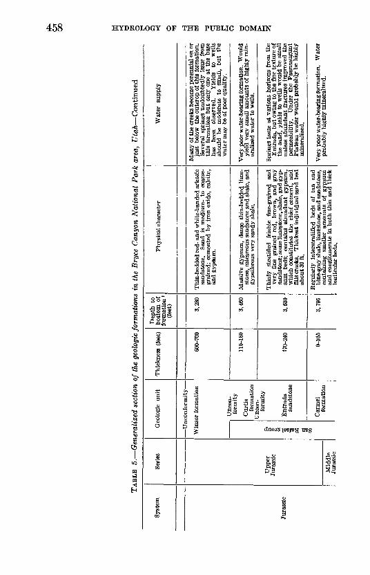
The thickness and the geologic and hydrologic character of the Mesozoic and Cenozoic rocks underlying Bryce Canyon National Park are given in table 5. Of these formations the oldest shown on the geologic map (fig. 55) is the Winsor formation of Late Jurassic age.
The Mesozoic rocks in table 5 are predominantly sandstone and shale with only minor limestone or conglomerate beds. Except for the Navajo sandstone, most formations have gypsum as a common cementing agent. This mineral is easily soluble, and thus may be present in much of the ground water contained in these beds. Gyp sum is not so common in rocks of Cenozoic age, which are mostly limestone or sand and gravel.

Oi
TA
BL
E 5
. G
ener
ali
zed s
ecti
on o
f th
e ge
olog
ic f
orm
ati
on
s in
the
Bry
ce C
an
yon
Na
tio
na
l P
ark
are
a,
Uta
h
Bas
ed o
n in
form
atio
n ob
tain
ed f
rom
sev
eral
sou
rces
, inc
ludi
ng G
rego
ry (
1951
), G
rego
ry a
nd M
oore
(19
31),
and
Har
shba
rger
and
Rep
enni
ng (
1954
)]
Syst
em
Qua
tern
ary
Ter
tiar
y
Seri
es
Rec
ent a
nd
Plei
stoc
ene
Eoc
ene
Geo
logi
c un
it
All
uviu
m
Was
atch
form
atio
n
Kai
paro
wit
s fo
rmat
ion
Thi
ckne
ss (
feet
)
0-13
6
500-
700
at t
he
rim
. 1,
000
at B
oat
Mes
a.
0-70
0 be
twee
n th
e E
ast
For
k of
the
Sevi
er R
iver
an
d th
e ri
m.
Abs
ent
in
Bry
ce a
nd
Cam
pbel
l C
anyo
ns.
400
in Y
ello
w
Cre
ek a
nd
Shee
p C
reek
ar
eas.
Dep
th t
o bo
ttom
of
form
atio
n 1
(fee
t)
0
500
900
Phys
ical
cha
ract
er
Gra
vel,
sand
, sil
t, an
d cl
ay f
illin
g th
e va
lley
bott
oms
of E
ast C
reek
, Dav
es H
ollo
w, a
nd
othe
r sm
all s
trea
ms,
and
the
val
ley
of th
e E
ast
For
k of
the
Sev
ier
Riv
er.
Att
ains
m
axim
um
thic
knes
s in
Em
ery
Val
ley.
Fi
lls v
alle
y bo
ttom
s of
Wat
er,
Cam
pbel
l, an
d B
ryce
Can
yons
, Y
ello
w
and
Shee
p C
reek
s, S
wam
p C
anyo
n, a
nd o
ther
can
yo
ns b
elow
the
rim
.
Upp
er w
hite
bed
s pr
esen
t on
Boa
t Mes
a an
d W
hite
man
B
ench
ar
e w
hite
, gr
ay,
or
light
-bro
wn
sand
ston
e, c
ongl
omer
ate,
and
lim
esto
ne c
onta
inin
g si
liceo
us c
emen
t an
d vo
lcan
ic tu
ff a
nd a
sh.
Mid
dle
pink
bed
s, c
hief
ly p
ink,
gra
y, a
nd
whi
te m
assi
ve l
imes
tone
and
int
erbe
dded
sa
ndst
one
and
cong
lom
erat
e.
Bas
al
cong
lom
erat
e co
nsis
ts
of
pebb
les
poor
ly c
emen
ted
by
calc
ium
ca
rbon
ate;
ab
sent
in
Sw
amp
Can
yon
and
Yel
low
C
reek
; 10
to
30 f
t th
ick
at B
ryce
Poi
nt,
com
pose
d of
san
dsto
ne a
nd c
ongl
omer
ate;
30
ft th
ick
at C
ampb
ell C
anyo
n, c
ompo
sed
of l
ense
s of
con
glom
erat
e in
lim
esto
ne.
Dar
k-gr
ay,
gray
-gre
en,
yello
w,
and
tan
coar
se-
and
med
ium
-gra
ined
ark
osic
san
d
ston
e po
orly
cem
ente
d by
cal
cium
car
bon
at
e an
d in
par
t by
gyp
sum
and
iro
n ox
ide.
B
row
n, w
hite
, and
gre
enis
h lim
esto
ne a
nd
blue
and
pur
ple
shal
e.
Con
tain
s ve
rte
br
ate
bone
s,
foss
il w
ood,
in
vert
ebra
tes,
an
d ir
onst
one
nodu
les
and
conc
retio
ns.
Wat
er
supp
ly
Gra
vel
and
sand
le
nses
in
th
e al
luvi
al
valle
ys
on
the
Pau
nsau
gunt
P
late
au
yiel
d as
muc
h as
18
0 gp
m t
o a
wel
l. G
rave
l fil
l in
the
can
yons
bel
ow t
he r
im
is v
ery
poro
us a
nd i
n th
e w
ashe
s th
is
grav
el
is
very
pe
rmea
ble;
yi
elds
lar
ge
quan
titi
es o
f wat
er w
here
sat
urat
ed,
but
in g
ener
al t
he g
rave
l con
tain
s w
ater
onl
y in
the
vic
init
y of
bed
rock
spr
ings
, w
ith
resu
ltan
t lim
ited
yie
lds.
The
w
hite
be
ds
supp
ort
spri
ngs
of u
n
stab
le y
ield
on
Whi
tem
an B
ench
. A
fe
w
smal
l sp
ring
s is
sue
from
sa
ndy
lens
es a
nd f
ract
ures
, but
the
bed
s ar
e no
t li
kely
to
yiel
d w
ater
to w
ells
. B
asal
con
glom
erat
e be
ds s
uppo
rt s
ever
al
spri
ngs
fust
bel
ow t
he r
im a
nd i
n th
e va
lley
of th
e E
ast
For
k of
the
Sevi
er.
If
lens
es o
f con
glom
erat
e ar
e pe
netr
ated
, the
ba
sal c
ongl
omer
ate
mig
ht y
ield
mod
erat
e qu
anti
ties
of w
ater
to w
ells
.
Yie
lds
wat
er t
o se
vera
l sp
ring
s be
low
the
ri
m.
Wel
ls th
at p
enet
rate
this
form
atio
n ha
ve v
ery
low
yie
lds
(10
gpm
or
less
).

Cre
tace
ous
Upp
er
Cre
tace
ous
Wah
wea
p sa
nd
ston
e
Str
aigh
t C
liffs
sa
ndst
one
Tro
pic
shal
e
Dak
ota
sand
ston
e
850+ 80
0 30
1,75
0
2,55
0
2,58
0
Yel
low
and
buf
f fi
ne t
o m
ediu
m s
ands
tone
, 40
to
60 f
t th
ick
in u
pper
par
t. In
ter-
be
dded
san
dsto
ne a
nd s
haly
san
dsto
ne i
n ex
tens
ive
lens
es in
low
er p
art.
Cem
ente
d m
ainl
y by
cal
cite
, bu
t ha
rd
laye
rs
are
cem
ente
d by
iro
n ox
ide.
C
onta
ins
som
e gy
psum
and
woo
d.
Tan
san
dsto
nes
mak
e up
95
perc
ent
of t
his
form
atio
n, a
nd s
ands
tone
lay
ers
grea
ter
than
10 f
t thi
ck m
ake
up 6
0 pe
rcen
t. So
me
of th
e sa
nd is
fin
e, b
ut m
ost
is m
ediu
m t
o co
arse
, an
d so
me
cong
lom
erat
es c
onta
in
pebb
les
1 to
3
in.
acro
ss.
Cem
ente
d m
ainl
y by
cal
cite
but
in p
art b
y so
me
iron
ox
ide.
D
isse
min
ated
gy
psum
an
d ca
r
bona
ceou
s be
ds
occu
r.
Blu
ish-
drab
cla
yey
to s
andy
sha
le;
irre
gu
larl
y be
dded
sa
ndst
ones
; ab
unda
ntly
fo
ssili
fero
us;
gyps
um a
nd s
elen
ite c
ryst
als
are
com
mon
. C
onta
ins
sand
len
ses
2 to
15
ft t
hick
and
car
bona
ceou
s be
ds.
Buf
f-gr
ay m
ediu
m-
to c
oars
e-gr
aine
d sa
nd
ston
e an
d co
nglo
mer
ate
cont
aini
ng s
ome
shal
e an
d ca
rbon
aceo
us b
eds.
Sa
ndst
ones
ar
e w
eakl
y ce
men
ted.
C
onta
ins
som
e si
licif
led
woo
d.
The
se t
wo
form
atio
ns s
uppo
rt m
ost
of t
he
prol
ific
spr
ings
bel
ow th
e ri
m.
Alt
houg
h no
w
ater
w
ells
pen
etra
te
thes
e fo
rma
tio
ns
in
the
Bry
ce
Can
yon
area
, th
ey
mig
ht y
ield
wat
er t
o w
ells
in
suff
icie
nt
quan
tity
for
a p
ubli
c su
pply
. T
he e
x
tens
ive
sand
ston
e la
yers
mak
e up
mos
t of
the
two
form
atio
ns w
hich
are
sat
urat
ed
thro
ugho
ut t
he a
rea;
thu
s, m
ost w
ells
are
ap
t to
pen
etra
te w
ater
-bea
ring
mat
eria
l. (L
ithol
ogic
eq
uiva
lent
in
th
e N
avaj
o In
dian
Res
erva
tion
yie
lds
20 t
o 40
gpm
.)
Ver
y po
or
wat
er-b
eari
ng
form
atio
n.
For
ms
impe
rmea
ble
barr
ier
alon
g P
aun-
sa
ugun
t fa
ult,
caus
ing
faul
tlin
e sp
ring
s.
Sand
ston
e le
nses
m
ight
pr
oduc
e sm
all
quan
titi
es o
f wat
er, b
ut s
uch
wat
er w
ould
be
hig
h in
cal
cium
and
sul
fate
and
pro
b
ably
of u
nsat
isfa
ctor
y qu
alit
y.
Spri
ngs i
ssue
from
the
base
of t
his f
orm
atio
n in
the
Par
ia V
alle
y.
If s
uffi
cien
t th
ick
ne
ss i
s pe
netr
ated
, th
is f
orm
atio
n w
ould
yi
eld
som
e w
ater
to w
ells
. It
is s
atur
ated
ev
eryw
here
w
est
of
the
Pau
nsau
gunt
fa
ult.
The
wat
er m
ight
be
of u
nsat
is
fact
ory
qual
ity
owin
g to
see
page
fro
m th
e ov
erly
ing
Tro
pic
shal
e.
(Yie
lds
5 to
10
gpm
in
Nav
ajo
Indi
an R
eser
vatio
n, b
ut
wat
er is
hig
hly
min
eral
ized
.)R
epre
sent
ativ
e of
dep
ths
and
thic
knes
ses
unde
rlyi
ng th
e vi
cini
ty o
f P
aris
Vie
w o
bser
vatio
n po
int i
n pa
rk.
Cn
00
TAB
LE 5
. G
ener
aliz
ed s
ectio
n of
the
geo
logi
c fo
rmat
ions
in
the
Bry
ce C
anyo
n N
atio
nal
Par
k ar
ea,
Uta
h C
onti
nued
Syst
em
Jura
ssic
Seri
es
Upp
er
Jura
ssic
Mid
dle
Jura
ssic
Geo
logi
c un
it
Win
s
San
Rafael group
or f
orm
atio
n
Unc
on
form
ity
Cur
tis
form
atio
n U
ncon
fo
rmity
Ent
rada
sa
ndst
one
Car
mel
fo
rmat
ion
Thi
ckne
ss (
feet
)
600-
700
110-
180
170-
240
0-16
5
Dep
th t
o bo
ttom
of
form
atio
n 1
(fee
t) 3,28
0
3,46
0
3,63
0
3,79
5
Phy
sica
l cha
ract
er
Thi
n-be
dded
red
- an
d w
hite
-ban
ded
arko
sic
sand
ston
e.
San
d is
med
ium
- to
coa
rse
gr
aine
d; c
emen
ted
by i
ron
oxid
e, c
alci
te,
and
gyps
um.
Mas
sive
gyp
sum
, de
nse
thin
-bed
ded
lime
st
one,
cal
care
ous
sand
ston
e an
d sh
ale,
and
gy
psif
erou
s ve
ry s
andy
sha
le.
Thi
nly
stra
tifie
d fr
iabl
e fi
ne-g
rain
ed
and
very
fin
e gr
aine
d re
d, b
row
n, a
nd g
ray
sand
ston
e; s
ome
limes
tone
, sha
le, a
nd g
yp
sum
be
ds;
cont
ains
ab
unda
nt g
ypsu
m,
whi
ch c
onst
itute
s th
e ch
ief
cem
ent,
and
fills
cra
cks.
T
hick
est
indi
vidu
al s
and
bed
abou
t 30
ft.
Reg
ular
ly i
nter
stra
tifi
ed b
eds
of t
an a
nd
blue
-gra
y sh
ale,
lim
esto
ne, a
nd s
ands
tone
, co
ntai
ning
sm
alle
r am
ount
s of
gy
psum
an
d co
nglo
mer
ate
in b
oth
thin
and
thi
ck
lent
icul
ar b
eds.
Wat
er
supp
ly
Man
y of
the
cree
ks b
ecom
e pe
renn
ial o
n or
ju
st b
elow
the
out
crop
of t
his
form
atio
n.
Seve
ral
spri
ngs
undo
ubte
dly
issu
e fr
om
this
for
mat
ion
bu
t on
ly o
ne a
t th
e ba
se
has
been
ob
serv
ed.
Yie
lds
to
wel
ls
shou
ld b
e m
oder
ate
to
smal
l, bu
t th
e w
ater
may
be
of p
oor
qual
ity.
Ver
y po
or w
ater
-bea
ring
form
atio
n. W
ould
yi
eld
very
sm
all
amou
nts
of h
ighl
y m
in
eral
ized
wat
er to
wel
ls.
Spri
ngs
issu
e at
var
ious
hor
izon
s fr
om t
he
Ent
rada
, b
ut
owin
g to
the
fin
e te
xtur
e of
th
e sa
nd,
yiel
ds t
o w
ells
wou
ld b
e sm
all
unle
ss a
bund
ant
frac
ture
s im
prov
ed t
he
perm
eabi
lity
. U
nder
the
Pau
nsau
gunt
P
late
au w
ater
wou
ld p
roba
bly
be h
ighl
y m
iner
aliz
ed.
Ver
y po
or w
ater
-bea
ring
form
atio
n.
Wat
er
prob
ably
hig
hly
min
eral
ized
.

Jura
ssic
and
Ju
rass
ic(?
)
Tri
assi
c
Upp
er
Tri
assi
c
Mid
dle(
?)
and
Low
er
Tri
assi
c
a o
o.|i!
^o60
Ohinle formatio
n
fort
uity
Nav
ajo
sand
ston
e
Unc
on
form
ity
Upp
er p
art
of C
hinl
e fo
rmat
ion
Shi
naru
mp
mem
ber
Unc
on
form
ity
Moe
nkop
i fo
rmat
ion
1,20
0-1,
800
600-
800
0-11
5
600
5,59
5
6,39
5
6,51
0
7,01
0
Lig
ht c
ream
y-ye
llow
, whi
te, a
nd b
uff h
ighl
y cr
ossb
edde
d sa
ndst
one.
F
orm
s th
e W
hite
C
liffs
.
Red
and
bro
wn
shal
e, s
ands
tone
, an
d lim
e
ston
e.
Red
and
gra
y co
nglo
mer
ate.
Cho
cola
te-b
row
n sh
ale
and
som
e sa
ndst
one.
Pro
babl
y w
ould
yie
ld l
arge
st a
mou
nts
of
good
-qua
lity
wat
er o
f an
y fo
rmat
ion
be
low
th
e W
ahw
eap
and
Str
aigh
t C
liffs
sa
ndst
ones
. (Y
ield
s as
muc
h as
70
gpm
in
the
Nav
ajo
Indi
an R
eser
vatio
n.)
Pro
babl
y no
t wat
er b
eari
ng.
May
yie
ld a
sm
all
quan
tity
of
wat
er t
o w
ells
, but
wat
er w
ould
pro
babl
y be
som
e
wha
t m
iner
aliz
ed.
Pro
babl
y no
t w
ater
bea
ring
.
so
i R
epre
sent
ativ
e of
dep
ths
and
thic
knes
ses
unde
rlyi
ng t
he v
icin
ity
of P
aria
Vie
w o
bser
vatio
n po
int
in p
ark.

EX
PLA
NA
TIO
N
Allu
viu
m
(Wat
er
bearing)
Was
otch
fo
rmat
ion
Koi
paro
wits
fo
rmat
ion
mm
Tro
pic
shal
e an
d D
akot
a sa
ndst
one,
und
iffer
entia
ted
Win
sor
form
atio
n
Faul
t
Pink
Clif
fs e
scar
pmen
t
g
FIG
URE
55.
Geo
logi
c m
ap o
f the
nor
ther
n pa
rt o
f Bry
ce C
anyo
n N
atio
nal P
ark
area
, Uta
h.
Mod
ified
fro
m G
rego
ry (
1951
).

GROUND WATER, BRYCE CANYON NATIONAL PARK AREA, UTAH 461
STRUCTURE
The principal structural features of the Bryce Canyon National Park area are gently northeastward-dipping beds and several major normal faults. The regional dip of the beds ranges from K° to 3° north, northeast, and east. Departures from the regional dip are found only in the immediate vicinity of faults and in gentle folds. A gently north-plunging anticline in the vicinity of Willis and Reward Creeks was described by Hager (1957). The axis of this anticline is west of the Pink Cliffs escarpment in the Heward Creek area, but it crosses the escarpment in the vicinity of Sheep Creek.
Faulting is restricted to a few large-scale normal faults; two of these faults the Paunsaugunt and Sevier are regional in extent. The Sevier fault is about 7 miles west of the area covered by this report. These two faults trend northward, and the east block of each fault is upthrown in relation to the west block. The Paunsaugunt fault does not coincide with the Pink Cliffs escarpment and, in fact, is not noticeable as a topographic feature of any kind. Two cross faults that trend generally eastward, connecting the Sevier and Paun saugunt faults, are evident as topographic features faultline scarps that form the borders of Emery Valley.
Each of these structural features exercises some control on the occurrence and movement of ground water in the bedrock aquifers of the area. Ground water moves through the rocks in the general direction of the regional dip, which accounts for the many springs along the eastern scarp of the Paunsaugunt Plateau. Along the Paun saugunt fault, springs occur where the eastward movement of ground water is blocked by upfaulted relatively impervious beds, which force the water to rise to the surface. Tension fractures along the axis of the Bryce Canyon anticline (fig. 55) might create secondary permeability and afford an opportunity to obtain successful water supplies from wells penetrating the bedrock.
WATER RESOURCES
SURFACE WATER
In the Bryce Canyon area there are only two perennial surface streams, the East Fork of the Sevi,er River and the Paria River, but short perennial reaches of tributary streams are fed by springs. The diversions of water by the Tropic and East Fork Irrigation Co. from the East Fork of the Sevier River into the Paria River drainage are shown in table 1. The U.S. Geological Survey gaging station (pi. 24) was installed primarily to record the amount of water in the Tropic Ditch that crosses the divide; it does not necessarily record the total amount of water released from the Tropic Reservoir.
644924 O 62 4

462 HYDROLOGY OP THE PUBLIC DOMAIN
SPRINGS
The springs of the Bryce Canyon National Park area may con veniently be divided into two groups: those on top of the Paunsau- gunt Plateau and those below the rim in the Paria River drainage area. Fluctuations in the flow of springs on top of the plateau are closely related to annual precipitation, whereas fluctuations of the flow of springs below the rim are not. On the Paunsaugunt Plateau are two types of springs bedrock and alluvial. The bedrock springs on the plateau may, in turn, be divided into those that issue from the white beds of the Wasatch formation and those that issue from the basal conglomerate of the Wasatch formation.
On the plateau several bedrock springs (for example, Shaker, Trough, and Whiteman) occur on the north and east sides of Whiteman Bench (pi. 24). It is thought that these springs occur where per meable beds in the sandy white beds of the Wasatch formation lie in contact with the denser pink limestone beds of the same formation. Inasmuch as all the springs issue from thin alluvium, it is difficult to determine the bedrock source. These springs are recharged by rain and snow that falls on top and around the margins of Whiteman Bench; the yields are unstable and fluctuate in response to variations in the amount and distribution of precipitation. In May 1957 Shaker, Trough, and Whiteman Springs were not flowing. The upper graph in figure 52 shows that in 1956 the cumulative departure from normal precipitation was at the lowest point during the period of record, which probably accounts for the cessation of flow from the bedrock springs on the plateau.
Above the Tropic Reservoir on the plateau are several springs that contribute water to short tributaries of the East Fork (pi. 24). The geologic map (fig. 55) shows that these springs issue from the Wa satch formation just above its contact with the underlying Kaiparowits formation. Gregory (1951, p. 46) states that the basal conglomerate of the Wasatch formation is present near the Tropic Reservoir, and it is thought that the springs issue from this permeable bed. How ever, these springs were not visited by the writer.
Springs on the plateau whose source is alluvium are probably present in most of the larger valleys. Seven of these springs are in East Creek valley (pi. 25), and these were the only ones visited by the writer. These springs had an insignificant flow in May 1957, and by June all flow had ceased.
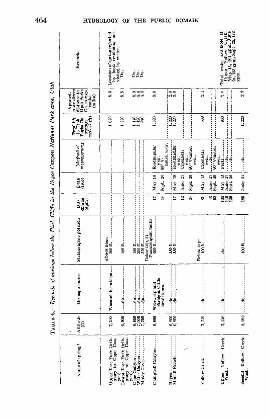
The second region of springs is below the rim in the Paria River drainage area, where springs issue from thin patches of alluvium which obscure their bedrock source. The locations of these springs are shown on plate 24, and table 6 gives their altitudes, the geologic formations from which they issue, and their respective stratigraphic positions. The geologic formations and stratigraphic positions from

GROUND WATER, BRYCE CANTON NATIONAL PARK AREA, UTAH 463
which these springs issue were determined from Gregory's geologic map (1951). Table 7 gives chemical analyses of water collected from selected springs.
Springs and seeps occur at many localities in the foothills below the rim on the east side of the Paunsaugunt Plateau. These are caused by the eastward and northeastward movement of water as it follows the dip of the more permeable beds. Sheep Creek, Swamp Canyon, Yellow Creek Springs, and the springs farther south along the rim are examples of springs that owe their existence to the out crop of permeable beds. Merrill Kanch, Bryce, and Campbell Canyon Springs are faultline springs. Figure 56 illustrates the mode of occurrence of most faultline springs in this area. The upthrown block of Tropic shale forms a relatively impervious eastern barrier, which forces water from the permeable beds in the Wahweap and Straight Cliffs sandstones to rise to the surface instead of continuing its northeastward movement.
Nearly all the springs below the rim issue from alluvium, which in some places is a thin layer obscuring the bedrock. The water emerg ing from these springs has a constancy of flow that indicates a bed rock source. If their source were the alluvium in the reentrants, these springs probably would not flow in dry seasons as the alluvium generally is insufficient to store enough water to support the flow, except in wet weather. The recharge area of these springs is restricted to the Paunsaugunt Plateau and immediately adjacent areas. Formations below the Wahweap and Straight Cliffs sandstones probably obtain part of their recharge from areas more distant than the plateau.
Table 6 gives the measured discharge of the springs below the rim in the Bryce Canyon area. Because the conditions at each spring are different, each will be considered separately with respect to its utilization for water supply. Springs north of Campbell Canyon were not visited by the writer, and no measurements of flow or chemi cal analyses are available.
Campbell Canyon Spring is within the National Park boundary and is 3 miles from the storage tanks of the Utah Parks Co. Water rises in a grassy marsh between two washes that join just below the spring. The water drops about 10 feet from the grassy area to the gravel in the stream wash proper. Within 300 feet of the point where the spring water flows onto the gravel of the wash, all surface water has disappeared. Development work might increase the yield of this spring slightly (table 3). The water is hard but otherwise of good quality (table 7), and, like that of other springs below the rim, the yield is fairly constant. The principal objection to the development of a water supply at this site is the low yield of the spring (table 6).
Oi
TAB
LE 6
. R
ecor
ds o
f sp
ring
s be
low
the
Pin
k C
liff
s in
the
Bry
ce C
anyo
n N
atio
nal
Par
k ar
ea,
Uta
h
Nam
e of
spr
ing
1
utar
y to
C
ope
Can
yo
n).
uta
ry
to
Cop
e C
an
yon)
.
Mer
rill
Ran
ch. .
........
\
Yel
low
Cre
ek. .
....
....
.
Was
h.
Seco
nd
Yel
low
C
reek
Was
h.
Alt
itud
e (f
t) 7,10
0
6,90
0
6,95
07,
000
7,25
0
6,80
0
6,90
06,
900
7,22
0
7,22
0
6,90
0
Geo
logi
c so
urce
_.
do .. ...
... .
.do. ..
... .
.......
....
.do
...
.... .
...
....
.do
...
....
. ...
...
Str
aigh
t C
liff
s sa
ndst
ones
.
.....d
o ..
.....d
o .. . _
-
..d
o.
....
... .
.. ..
.
....
.do
. ..
....
....
...
.....d
o .............
Str
atig
raph
ic p
osit
ion
Abo
ve b
ase:
in
n ft
10
0ft
...
........
15
0ft
... .
........ ..
32
0ft
....
....
....
..5
70ft
...... ...
Bel
ow to
p, a
t P
auns
augu
nt f
ault
: 200ft
350ft.
.
550ft
...... ..
......
Bel
ow t
op:
100
ft
.
.
do
40
0ft
....
....
....
..
Dis
ch
arge
(g
pm) 17 28 17 1
9 24 81 4.O CO
120
140
120
185
Dat
e (1
957)
May
18
Sep
t. 24
May
18
May
15
Qan
t O
l\
May
15
Sep
t. 25
Jun
e 21
Met
hod
of
mea
sure
men
t
Rec
tang
ular
wei
r.
90°
V-
Rec
tang
ular
wei
r.
wei
r.
90°
V-n
otch
wei
r.
Cip
olle
tti
wei
r.
d
o. ..
...
90°
V-n
otch
wei
r.
Flo
at
......
.... .do ..
. d
o ..
. .
do
Tota
l li
ft
to U
tah
P
arks
Co.
st
ora
ge
tanks
2 (f
t)
1,02
0
1,22
0
1,17
01,
120
870
1,32
0
1,22
01,
220
900
900
1,22
0
App
roxi
m
ate
dir
ect
dis
tan
ce t
o
Uta
h P
arks
Co.
sto
rag
e ta
nks
(mil
es) 6.
9
6.5
6.3
4.4
4.3
3.0
2.3
3.0
2.1
2.1
2.9
Rem
ark
s
Loca
tion o
f sp
rin
g r
epo
rted
by
loca
l re
sid
ents
; n
ot
vis
ited
by w
rite
r.
Do.
Do.
Do.
Do.
Tota
l w
ater
av
aila
ble
at
Upp
er
Yel
low
C
reek
:M
ay 1
5, 2
01 g
pm;
June
21,
183
gpm
; Se
pt.
25,
172
gpm
.

Eig
ht F
ork
(of
Yel
low
Cre
ek).
Was
h.
7,22
0
So
nn
7,27
0
7,27
0
7,12
0
8,20
0
8,25
08
inn
8,05
0
8,10
07,
775
8q
cn
7,50
0
7,75
0
d
o .
Str
aigh
t C
liffs
sa
ndst
ones
.
i .d
o .
... .
... .
.. ..
.
do.
... .
.do..
....
...........
... .
.do......... .
....
...
tion
.
....
.do
....-
._
.-
do.
Str
aigh
t C
liffs
sa
ndst
ones
. ... .
.do.......... .
10
0ft
600ft
200ft
.d
o ..
..
350ft
do
. ..
....
do .
Abo
ve b
ase:
2
50
ft
35
0ft.
.... .d
o.... ..
....
. .
40
0ft
.
75 60 11 2 48 34
Seep
;no
fl
ow.
June
21
Sept
. 25
May
20
Sept
. 24
May
20
Sept
. 24
Sept
. 24
do
mat
e.
Eec
tang
ular
wei
r.
90°
V-n
otch
wei
r.
Eec
tang
ular
wei
r.
90°
V-n
otch
wei
r.
Vis
ual e
sti
mat
e.
900
870
870
1,00
0
2.1
3.4
d
o.... .
4.0
by
loca
l re
side
nts;
no
t vi
site
d by
wri
ter.
D
is
char
ge m
easu
red
1 m
ile
dow
nstr
eam
fr
om
re
port
ed s
ourc
e.
junc
tion
of
Shee
p C
reek
an
d Sw
amp
Can
yon:
24, 3
6 gp
m.
plot
ted
on m
ap,
but
not
visi
ted
by w
rite
r.
Do.
Do.
Geo
logi
cal
Sur
vey
topo
gr
aphi
c m
ap.
Nei
ther
se
en
nor
visi
ted
by
wri
ter.
D
o.D
o.D
o.D
o.
Do.
o
1 Se
e pi
. 24
for
loca
tion
and
tabl
e 7
for
chem
ical
ana
lysi
s of
wat
er.
a Alt
itud
e of
sto
rage
tan
ks (
8,12
0) i
nter
pola
ted
from
top
ogra
phic
map
.

EX
PL
AN
AT
ION
01
FIG
URE
66.
Gen
eral
ized
eas
t-wes
t cro
ss s
ectio
n th
roug
h M
erri
ll R
anch
Spr
ing
show
ing
the
mov
emen
t of g
roun
d w
ater
in re
latio
n to
the
occu
rren
ce
of a
ll fa
ultli
ne s
prin
gs in
the
area
. D
oubl
e-ba
rbed
arr
ows
repr
esen
t dir
ectio
n of
wat
er m
ovem
ent;
cros
shat
ched
are
a re
pres
ents
zon
e of
satu
ra
tion.
T
w,
Was
atch
for
mat
ion;
Kk,
Kai
paro
wits
for
mat
ion;
Kw
s, W
ahw
eap
and
Stra
ight
Clif
fs s
ands
tone
s, u
ndif
fere
ntia
ted;
Ktd
, T
ropi
c sh
ale
and
Dak
ota
sand
ston
e, u
ndif
fere
ntia
ted.

Bryce Canyon Airport well.
Alluvium and Kaiparowits formation.
?
gCO Cn
;
g
00
CnCO
§-
o
1to
gs00
CO
w
i
Cj O2 O2 1-3 ffi Kj g
W 2 a ^SS ^£, 2 pw £ B ^0 p e S P p g » ^3
£ »02| £ 5 ip £?"&' i 5 ^ S*M 3. 5 P* 0> ^ 5 2. 2 S P
1 IS! p 1
ill i * !S 1 £* .to H-
r* s s -8P s
81 O H-L 1 1 1 O 1 H-i i bO O | i I CO] OS
rf*. CO CO tO 00 CO-^OtOi picn *J 55 o Oi cncooicc" co
ssS g s ^efiK ei tO bO i -I -1 tO i IsS CO' 00 O i Cn i 00
CD tO OS Cn O tO 00 tO H^ ^
OS CO $. CO CO tO Cn CO 00 CO^OO Cn CO OOOSbOCO ^
*. 00 O tO 00 pOCnpOtOtO 00 O O«.OOO
*.! CO CO 1 ! ' OS] «.
Cn H^ o 00 *^ ^ ̂ t-i o H^
tooo-q os 02*. co *.COCnOS 0 t§" ^ CO
iss i i gsgg iCO i CD tO I 1 i OOl H^ COCO CO 1
H-^J bO =3 CO bO r
CO <I 00 ^ H-i rfa-Ot bOCC" 1 '
**> > U UUI.U ^
!«?9
Campbell Canyon Spring.
Wahweap and Straight Cliffs
isoco
OS
! oI g1*-COcoos
wcogCO
totsCO t^
-ICO
to too
1 OS
~0
to to
SI
0000
*>
I
02
1S
Q S
I
iSf||
Specific conductance (micromhos at 25° C)
Silica (SiOs)
Iron (Fe)
Calcium (Ca)
Magnesium (Mg)
Sodium and potas sium (Na+K)
Bicarbonate (HCO3)
Sulfate (SO<)
Chloride (Cl)
Fluoride (F)
Nitrate (NOj)
Dissolved solids (sum)
Carbonate Qpfl
Noncarbonate » |
pH
Analyst i
g
~
<a s
5- I
"" S"B «1 bo
'vsravaoiaa 'HCKLVAL

468 HYDROLOGY OF THE PUBLIC DOMAIN
Bryce Spring supplies drinking and culinary water to the town of Tropic. Residents estimate that the flow is about 1 cfs (cubic foot per second); however, the flow of the spring was not measured by the writer. Gregory (1951, p. 112) said that Tropic received 38 gpm from this spring area.
Merrill Ranch Spring is 1% miles east of the Pink Cliffs along the Paunsaugunt fault (fig. 56). The water rises in a grassy area, as does that of several of the other springs, but it does not empty into a gravel-bottomed wash as it does at the others. Sandy clay is at the surface in both the source area for the spring, and at the spring. Owing to the clayey nature of the surface material at the spring, it would be difficult to increase the yield of the spring substantially by development work. The yield is small (table 6), and even a 50- percent increase would not provide enough water for the present water need of the park.
Certain of the springs in Yellow Creek offer the best possibility for the development of a water supply from a spring source. The springs in Yellow Creek (pi. 24) have been subdivided for discussion as follows: (1) Yellow Creek Spring and (2) Upper Yellow Creek Wash Spring in the upper reach of Yellow Creek; (3) a marshy area south of Yellow Creek but in the vicinity of (1) and (2); (4) Secpnd Yellow Creek Wash Spring above the junction of Yellow Creek with North Fork; (5) Right Fork (of Yellow Creek) Spring; (6) Third Yellow Creek Wash Spring below Ott Ranch.
Water first appears in Yellow Creek at Upper Yellow Creek Wash Spring (2) and is joined a short distance downstream by water from Yellow Creek Spring (1). It flows downstream for a distance that varies with the amount of water flowing from the two springs and with the season, but in June 1957 it was about a quarter of a mile. Below this the bed of Yellow Creek was dry for a distance of slightly less than a mile. Water appeared again in the channel at the Second Yellow Creek Wash Spring (4). In 1957 all this water was diverted into a ditch parallel to Yellow Creek that carries it to Ott Ranch (pi. 24), but, according to residents of the area, water would be visible in the bed of Yellow Creek all the way to Ott Ranch if it were not diverted. Below Ott Ranch, Yellow Creek was dry to the Third Yellow Creek Wash Spring (6).
The water from the upper spring area (1 and 2) of Yellow Creek is of good chemical quality for domestic needs (table 7), and the quantity is sufficient for the park needs (table 6). An additional advantage of this source is the possibility of expansion as the need for water in the park grows. The principal disadvantage of the upper spring's source is that it is not readily accessible. The upper spring area can be seen from the Paria View observation point (fig. 57),

GROUND WATER, BRYCE CANTON NATIONAL. PARK AREA, UTAH 469
FIGUBE 57. Yellow Creek Spring (circled) and Yellow Creek seen from Paria View observation point.Photograph by H. A. Waite.
and it might be necessary to camouflage any structures placed there, so as not to spoil the view. A pipeline to the top of the rim would be necessary for development of the upper spring area of any of the spring's sources below the rim.
Yellow Creek Spring (1) issues in a grassy marsh covering about 2 acres near the base of the Pink Cliffs. From this spring area the water drops about 10 feet into the bed of Yellow Creek, where the water flows perennially. The relative positions of Yellow Creek Spring and Yellow Creek Wash are shown in figure 57. The water in the channel first appears opposite the upper end of the spring area and probably comes from the same permeable bed in the Wahweap and Straight Cliffs sandstones that supplies the spring. On the south side of the wash is another grassy marsh (3) which suggests an additional outcrop of this permeable bed in the Wahweap and Straight Cliffs sandstones. Although this area is soggy and wet, no visible flow leaves it.
Inasmuch as the measured flow of Yellow Creek Spring (1) and Upper Yellow Creek Wash Spring (2) (table 6) represents only the water at the surface, more water probably could be obtained by proper development work at this source. A substantial part of the water
644924 O 162 5

470 HYDROLOGY OF THE PUBLIC DOMAIN
flowing at the surface in the permeable wash must be sustained by underflow. Construction of a tile drain under the channel possibly would make available additional water. Any surface works con structed in the wash proper would be subject to destruction by the occa sional but violent cloudburst floods that are responsible for emplacing the boulders and cobbles that make up the floor of the wash. Any construction in gravel washes should be planned with the destructive nature of these storms in mind. It is believed by the writer that the amount of surface discharge in Yellow Creek combined with the increased amount available as a result of development work would be sufficient for the park needs for a long time.
At the Second Yellow Creek Wash Spring (4) water appears in the permeable gravel of Yellow Creek Wash. Water from this point flows at the surface in an unlined ditch for more than 4 miles down stream where it is used at Ott Ranch. Water from the Right Fork (of Yellow Creek) Spring (5) disappears into the permeable gravel about 150 yards upstream from the point where the wash joins Yellow Creek. The source of this water was not seen by the writer, and the location of the spring shown on plate 24 was reported by a local resident. Farther down Yellow Creek Wash, water appears again at the Third Yellow Creek Wash Spring (6) but is of very poor chemical quality (table 7).
Table 3 shows that there is sufficient water in the upper spring area of Yellow Creek to supply the park needs. If the upper spring area is developed for a water supply, laying the pipeline for some dis tance northward before having it ascend the Pink Cliffs might insure that the Right Fork Spring (5) would be conveniently near the pipe line, should additional water be needed in the future.
The Sheep Creek Spring (pi. 24) rises from small amphitheaters in the alluvium of the stream. The Swamp Canyon Spring rises from a grassy marsh several acres in area. The water from Swamp Canyon Spring collects in a channel and flows for several hundred yards before it joins Sheep Creek. The yields from these two springs were measured separately a few score feet above their junction (table 6). Development work at Swamp Canyon Spring probably could increase the yield, but it is doubtful that much could be done to increase the yield of Sheep Creek Spring. The proximity of these springs and the presence of similar chemical constituents in water derived from them indicate that both springs have a common bedrock source in the Wah- weap and Straight Cliffs sandstones. The high sulfate and calcium content is noteworthy and strongly suggests that abundant gypsum (CaSO4) is present in the aquifer (table 7). The high content of cal cium and sulfate in this water makes it undesirable for a public water supply, although the spring area is probably the most accessible of any
GROUND WATER, BRYCE GANYON NATIONAL PARK AREA, UTAH 471
below the rim. These springs can be reached by jeep from the lodge and headquarters area. About 1 mile downstream from Sheep Creek Spring, on the side of a hill on the east slope of Sheep Creek valley, is a seep area called the Second Sheep Creek Spring (table 6; pi. 24). This spring issues from the Wahweap and Straight Cliffs sandstones and is unique in that alluvium does not obscure its bedrock source.
Springs south of Sheep Creek were not considered as possible sources of water for the lodge and headquarters area because of the availability of adequate water supplies nearer the area of use.
GROUND WATER IN ALLUVIUM
The area on the Paunsaugunt lHateau underlain by saturated alluvium is small compared with the area underlain by saturated bed rock. However, owing to the greater permeability of alluvium, these areas are of relatively great importance to the water resources of the region. In the Bryce Canyon area, the most significant deposits of alluvium occur beneath the valley bottoms of Emery Valley, the East Fork of the Sevier River, East Creek, Daves Hollow, and smaller tributaries to the East Fork.
EAST CREEK VAIUSY
In the summer of 1957 the water supply for Bryce Canyon National Park was obtained first from one well (well 1) and later from two wells (wells 1 and 2) in East Creek valley near the alluvial springs formerly used for a water supply. To determine if the water yield of this valley were sufficient for the park needs and if the valley could support a larger development than existed in 1957, greater emphasis was placed on investigating the ground-water resources of the alluvium in this valley than was given to other bodies of alluvium. This valley is in a favorable location because it is only a little more than 2 miles from the Utah Parks Co. storage tanks and because the pump ing lift is only 372 feet.
Because of the water-supply developments in East Creek valley, more information was available on the quantity and dependability of the water yield from this alluvial body than from others. Infor mation on these developments in East Creek valley is included in the section on "Water Use."
The flow of East Creek, when not caused by cloudbursts, is con trolled principally by the ground-water level in the adjacent alluvium. Springs and seeps occur only when the amount of water in the alluvium of East Creek valley is in excess of the amount required for saturation and for supplying water-using plants that are abundant in areas of high water table. When sufficient water is released to the surface, it flows down East Creek. In late summer of 1955 and in 1956 and 1957 East Creek did not flow, suggesting that the alluvium in the
472 HYDROLOGY OF THE PUBLIC DOMAIN
valley was not saturated to the extent that it had been in previous years.
The cessation of flow in East Creek was due principally to a defi ciency of precipitation over a period of years. The upper graph of figure 52 shows the cumulative departure from normal precipitation at Bryce Canyon National Park for the period 1933 through 1956. According to the U.S. Weather Bureau, the normal annual pre cipitation at Bryce Canyon National Park is 17.34 inches. The cumulative deficiency during the period from 1947 through 1956 amounted to about 33 inches, nearly 2 years' normal supply. The effect that this deficiency of precipitation had on the amount of water stored in the alluvium in East Creek valley is not known, but it probably was substantial.
Some of the recharge to the alluvium comes frork bedrock springs. Whiteman Spring, at the toe of Whiteman Bencm is tributary to East Creek, and when the spring flows it supplies some recharge to the alluvium along that stream. Fluctuations in the\flow of White man Spring and other bedrock springs on the Paunsa'ugunt Plateau probably bear a closer relation to the cumulative departure from normal precipitation than to the yearly precipitation. Whiteman Spring wa& dry in the summer of 1957; therefore, it contributed no recharge to the alluvium of East Creek valley. Although 1957 was a year of above-normal precipitation, several such years may be required to restore the flow of Whiteman Spring to its former normal volume.
A water-level recording gage was in operation on Utah Parks Co. well 3 from April 26, 1957, to October 23, 1957. The hydrograph of this well shows that the water level in the alluvium of East Creek valley continued to decline as long as water was being pumped from the basin, indicating that the withdrawal exceeded the recharge. This is substantiated by the reaction of the water level to inter mittent pumping in May 1957. The water level recovered when the pump was turned off, but not to the original static water level.
To determine how much water is stored in the ground-water reservoir in the alluvial valley, the flat valley floor, herein considered to represent the part of the valley underlain by alluvium, was mapped (pi. 25A). The slopes of the sides of the valley also were measured at selected points. In constructing the cross sections of the valley fill, it was assumed that the slopes of the valley sides persist beneath the alluvium (fig. 58).
Figure 59 was constructed by combining the cross sections of figure 58 with the section of plate 25B. It is believed by the writer that

800 ft
Be
dro
ck 830 f
t
50
50
10
0 15
0 F
EE
T
NO
V
ER
TIC
AL
EX
AG
GE
RA
TIO
N
325 ft
100
ft
FIG
UBE
58.
Sel
ecte
d sc
hem
atic
cro
ss s
ectio
ns a
cros
s E
ast
Cre
ek v
alle
y sh
owin
g ap
prox
imat
e th
ickn
ess
of a
lluvi
um.
The
loca
tions
of t
he c
ross
sec
tions
are
sho
wn
on p
late
25A
.S3

474 HYDROLOGY OF THE PUBLIC DOMAIN
FIGURE 59. Schematic diagrams of saturated alluvium in parts of East Creek valley, May 1957. A, segment between cross sections A-A' and B-B'; B, segment between cross sections B-B' and C-C'. Locations of cross sections are shown on plate 25A.
the resulting geometric figures are representative of the approximate shape and dimensions of the alluvial fill.
On the assumptions that (1) about 32 percent of the alluvium is water bearing (average in wells 1-3; table 4); (2) the specific yield (drainable pore space) of the water-bearing material is about 20 percent; and (3) the total volume of saturated alluvium is about 40 million cubic feet (volume of the parts with the ruled pattern in fig. 59, the volume of ground water in storage in the alluvium between cross sections A-A' and C-C' is estimated to be about 2.6 million cubic feet. This amount of water might be available to a well that pene trated 60 feet of alluvium, that was equipped with a pump whose bowls were set at the bottom of the well, and that was pumped long enough. None of the wells of the Utah Parks Co. were drilled through as much as 60 feet of alluvium.
The ground-water storage available to the wells of the Utah Parks Co. may be estimated by subtracting the volume of ground water in

GROUND WATER, BRYCE, CANYON NATIONAL PARK AREA, UTAH 475
storage below 25 feet in depth (about 1.2 million cubic feet) from the total storage in East Creek valley. The total volume of ground water available to these wells as of May 1957 thus amounted to about 1.4 million cubic feet.
In this estimate it is assumed that the water table in the alluvium could be lowered in successive stages without the formation of exces sively deep cones of depression. In the late summer of 1957 the cones of depression around both the existing wells were steep, and because of this circumstance it was not possible to develop the maximum amount of water from storage.
A chemical analysis of the water from well 1 is shown in table 7. This water is of very good chemical quality, and water of comparable quality probably can be obtained from wells anywhere in the alluvium of East Creek valley.
OTHER AU^UVlUM-PILiLED VAULEYS
Ground water probably occurs in the valley of the East Fork of the Sevier River under conditions very similar to those of East Creek valley. Because the drainage area of the East Fork is larger and the volume of alluvium in the valley is larger, the yield of ground water from the East Fork valley would probably be more dependable than that from East Creek valley.
Because the drainage area of Daves Hollow (about 5.4 square miles) is about half that of East Creek (11.2 sq. mi., of which about 9.3 sq. mi. is above the pumphouse), the ground-water yield would probably be less dependable than that from the alluvium of East Creek valley. The yields of wells drilled in Emery Valley are small, which suggests that the water-bearing material is not highly productive. The total ground-water storage of this valley may be large, however.
GROUND WATER IN BEDROCK
The water-bearing properties as well as the geologic characteristics of the Cenozoic and Mesozoic formations that underlie the Bryce Canyon area are shown in table 5. The principal bedrock units that might yield water to a well, from the surface down, are (1) the basal conglomerate of the Wasatch formation, (2) the Wahweap and Straight Cliffs sandstones, (3) the Dakota sandstone, (4) parts of the Winsor formation, (5) the Entrada sandstone, (6) the Navajo sandstone, and (7) the Shinarump member of the Chinle formation.
The basal conglomerate of the Wasatch formation (1) is lenticular and might be missing at any particular place. A well drilled into the basal Wasatch in the vicinity of Bryce Point, where Gregory (1951, p. 46) reported the conglomerate to be 10 to 30 feet thick, might be successful, but there is no evidence to indicate potential

476 HYDROLOGY OF THE PUBLIC DOMAIN
yields. Even if a permeable lens of coarse material were penetrated, it might not be extensive enough to yield water perennially.
The Wahweap and Straight Cliffs sandstones (2) support many springs in the area, and in the Yellow Creek vicinity these sandstones yield water in large quantity. Most of the springs issuing from the Wahweap and Straight Cliffs sandstones supply excellent drinking water, but water from Swamp Canyon and Sheep Creek Springs has a high sulfate content (table 7). It is entirely possible that a well drilled into the Wahweap and Straight Cliffs sandstones might encounter water of similarly poor quality.
The Dakota sandstone (3) is thin and for this reason would not be expected to yield large quantities of water, Because the overlying Tropic shale contains abundant gypsum, water from the Dakota sandstone probably would be high in dissolved minerals owing to seepage from above.
It is likely that water from the Winsor formation (4) also would be appreciably mineralized owing to the gypsum contained in the formation.
Water from the Entrada sandstone (5) probably is somewhat mineralized because of the abundance of gypsum in this formation, and yields would probably be small,
The Navajo sandstone (6) is 1,200 to 1,800 feet thick and perhaps thicker, and the minimum depth to the top of the formation is about 3,800 feet. Water from the Navajo sandstone might be of good quality because the sandstone is made up dominantly of quartz sand. The Navajo sandstone might yield water in sufficient quantity to supply the needs of the park.
Water from the Shinarump member of the Chinle formation (7) is probably highly mineralized in this area and could be obtained only by drilling a well 6,500 feet or more deep.
Conclusions about the quality of the water in the several formations are supported by an electric log of one oil test in the area.
If a bedrock test well is attempted, it is recommended that it be drilled to the top of the Tropic shale at a depth of about 2,000 feet, in order to test the entire section of the Wahweap and Straight Cliffs sandstones. Because these are marine sandstones, they are probably fairly uniform but relatively low in permeability under most of the area in which a deep well would be drilled. Any bedrock test well should be located as far as practical from the ground-water discharge area below the rim, and where there is a favorable opportunity to intercept fracture zones in the Wahweap and Straight Cliffs sand stones. The axis of the anticline described by Hager (1957), if ex tended, passes through Bryce Canyon, although the Bryce Canyon area is beyond the limits of his map. It is therefore recommended

GROUND WATER, BRYCE CANTON NATIONAL PARK AREA, UTAH 477
that any bedrock test well be located near the crest of this anticline so that the greatest number of tension fractures will be encoun tered. The location of a recommended test site is shown on plate 24.
It would seem that the chances of obtaining good water between the base of the Wahweap and Straight Cliffs sandstones and the Navajo sandstone are small. Therefore, unless it is intended to drill to the Navajo sandstone, at a depth of about 3,800 feet below the surface at the test site indicated on plate 24, there seems to be little reason to drill below the base of the Wahweap and Straight Cliffs sandstones. Several water-producing sands should be penetrated by a well drilled through the Wahweap and Straight Cliffs sandstones, but whether the yield of such a well would be sufficient for the park needs depends on the amount of fracturing in these formations.
CONCLUSIONS
The Bryce Canyon National Park needed about 1.3 million cubic feet of water for about 250,000 visitors in 1957 (table 3). According to the Mission 66 estimate, water facilities will have to be provided for about 500,000 visitors a year (fig. 51). To evaluate water sources, a hypothetical future requirement of about 5 million cubic feet of water per season was used.
Possible sources of water for the park facilities include (1) surface water from the East Fork of the Sevier River, (2) water from wells in alluvium in the valley of the East Pork or in East Creek valley, (3) water piped up from springs below the Pink Cliffs, and (4) water from one or more wells drilled into bedrock.
Wells in the alluvium of East Creek valley could be an important source of water but not the sole source of water for the park. Al though the potential quantity available is small, the quality of the water is good and quite satisfactory for all uses in the park. The low pumping lift to the storage tanks (372 ft) of the Utah Parks Co. makes this source of water a very desirable one. Sufficient water is available from this source to meet all but peak tourist-season needs; during periods of peak demand an additional source is needed.
Of the springs below the Pink Cliffs, only springs in the Yellow Creek area are considered, because of their proximity to the park facilities, and because other springs that are not so close are lacking in either yield or quality. The Yellow Creek springs are dependable and yield water satisfactory in quality and adequate in quantity to supply all water needs created by any foreseeable expansion of the park.
A well drilled to the top of the Tropic shale (about 2,000 ft) should penetrate one or more aquifers in the Wahweap and Straight Cliffs sandstones, and perhaps one at shallower depth at the base of the

478 HYDROLOGY OF THE PUBLIC DOMAIN
Wasatch formation. A well drilled on the plateau about 1% miles northwest of Yellow Creek Spring (pi. 24) would lie near the axis of an anticline and might penetrate rock made relatively permeable by tension cracks.
DRILLING OF A TEST WELL
On the basis of information given in this report, the National Park Service decided to drill a well into bedrock to test the quantity and quality of water that could be produced from the Wahweap and Straight Cliffs sandstones. The test well was located approximately at the site shown on plate 24 and was to be drilled to the top of the Tropic shale or to 2,000 feet, whichever was shallower.
For the drilling of this test well, the cable-tool method was chosen. This method was preferable to the hydraulic rotary method for the following reasons:
1. It was anticipated that the final yield of the well would be the aggregate of the yield of many thin water-bearing zones. The cable- tool method would make detection of these small zones easier.
2. Because the final yield of the well would probably come from fracture porosity rather than "between-the-grain" porosity, it would be necessary to keep the diameter of the mud-invasion zone to a minimum. This should make development easier after completion of the hole. The bottom of a hole drilled by the cable-tool method is under less fluid pressure than is the bottom of a hole drilled by the rotary method, and therefore has a smaller mud-invasion zone.
3. Because there was a possibility of encountering water of unsuit able chemical quality, it was advisable to have an inexpensive method of obtaining relatively clean water samples. These could be obtained from the bailer.
4. Water-level measurements could be made easily at any time during the drilling of the well.
The rotary method of drilling had two advantages over the cable- tool method.
1. Drilling would be faster.2. The probability of the sides of the hole caving in would be
lessened. However, because this was a test hole, the information produced by the cable-tool method outweighed the mechanical ad vantages of the hydraulic rotary method. Rotary-air drilling was not considered separately from the hydraulic rotary method because the anticipated saturation of the material penetrated would have demanded conversion to hydraulic rotary when fracture zones were encountered.
The contract for drilling the test well was awarded to Perry Bros. Drilling Co., of Flagstaff, Ariz. Drilling began in August 1959. The

GROUND WATER, BRYCB CANYON NATIONAL PARK AREA, UTAH 479
first string of casing was 16 inches in diameter, and the hole was about 18 inches. Subsequently the casing size was decreased to 14, then to 12, and finally to 10 inches. Owing to many unexpected caving zones and the onset of winter, the hole was not finished until May 1960.
Many caving zones were encountered in the course of the drilling, ranging from severe cave-ins which buried the drilling bit and broke the cable, to mere sloughing of the side walls. It is difficult to deter mine the exact location of many of these zones because the material fell into the hole from an unknown height above the bottom. Although there were many caving zones, one seems worthy of partic ular mention because of its size and persistence. When the depth of the hole was 650 feet, a loose running sand filled it to a depth of 400 feet. It is not known exactly where this sand entered the hole; it may have been at 400 feet, or it may have been the entire zone between the depths of about 500 and 600 feet. The neutron log (pi. 26) shows that it was probably the latter. Other caving zones indicated that the bit could not advance far ahead of the bottom of the casing without trouble. Much of the lower part of the hole was underreamed to prevent these difficulties.
Owing to the problem of caving, four strings of casing of different diameters were used. A record of the depths of each casing size is shown on plate 26.
A composite driller's and sample log is shown under "lithology" on plate 26. The formations penetrated are identified from considerations of the driller's log, sample log, and the gamma ray and neutron logs. The top of the basal conglomerate of the Wasatch formation and the top of the Kaiparowits formation are easily identified. However, owing to the similar lithologies of the two formations, there is less certainty about the top of the Wahweap and Straight Cliffs sandstones. It is believed by the writer that the well did not penetrate the Tropic shale.
Most of the samples of the Wahweap and Straight Cliffs sandstones from the well are blue or gray sandy shale. This is different from the lithology of most of these formations in outcrops below the rim where they consist of tan sandstones alternating with blue shales. In the well the more neutral tan colors may have been obscured by the stronger blues. It is difficult to account for the absence of sandstone in the driller's and sample logs. However, the weakly cemented sandstones may have appeared as loose sand and become mixed with shale from other parts of the hole to give the appearance of sandy shale.
Gamma ray and neutron logs were made to check driller's and sample logs, and are shown on plate 26. They were very helpful in selecting the zones to be perforated (pi. 26); however, they did not

480 HYDROLOGY OF THE PUBLIC DOMAIN
show any thick sequences of sandstone. Other factors used in selecting the zones to be perforated were reports of caving zones, water levels measured while the hole was being drilled (pi. 26), and chemical analyses of water samples collected by the bailer while the hole was being drilled (table 8).
Water levels during drilling usually are depressed owing to the increased specific gravity of the muddy water in the hole. When a zone is perforated and cleaned the water level is higher. These two types of water-level information are distinguished on plate 26. The final composite water level of all zones that were perforated and cleaned was 647 feet below the surface. Above this level are several perched water bodies, and below this are several zones that have a much lower water level associated with them.
The well was perforated from the bottom upward, and as each zone or group of zones were perforated and cleaned, a water sample was obtained for chemical analysis. These analyses are given in table 8. While the well was pumping samples were collected also, and the analyses of these samples showed the water to be of similar chemical character to the perforated zone between depths of 860 and 890 feet. The reason for this was that the pumping water level was not below the static level of the better quality water zones. The entire 200 gpm that was finally produced, therefore, came exclusively from the 860 to 890 foot zone or above.
Two pumping tests were made, and a graph of the final one is presented in figure 60. However, it must be emphasized that this was not a test of the water-yielding ability of the lower three perfo rated zones. The lower two of these zones were bailed at a rate of 20 gpm. The pumping test indicated that the well had a specific capacity of 1.5 gpm per ft of drawdown and that it would yield 200 gpm without excessive drawdown.
Additional measurements have been made on several springs in the area. Because the measurements in table 6 are only indicative of the flows in 1957, the additional measurements are reported in table 9. The well was not pumped for a sufficient length of time to determine whether or not it affected the flow of Yellow Creek Spring.

64
0
66
0
UJ <
680
i 7
00
Q
72
0
74
0
z
760
UJ >
780
80
0
-15
0 g
pm
Au
gu
st
25
, I9
60
P
umpi
ng
rote
2
00
g
pm
8 10
12
14
16
18
TIM
E
SIN
CE
P
UM
PIN
G
BE
GA
N,
IN
HO
UR
S
20
2224
26
FIG
UB
E 60
. Gra
ph o
f the
wat
er le
vel d
urin
g pu
mpi
ng o
f the
tes
t wel
l at
Bry
ce C
anyo
n N
atio
nal
Par
k, U
tah.
00

00
bO
TA
BL
E 8.
Che
mic
al a
na
lyse
s of
wat
er f
rom
the
tes
t w
ell
at B
ryce
Ca
nyo
n N
ati
onal
Park
, U
tah
[Che
mic
al c
onst
ituen
ts a
re g
iven
in p
arts
per
mill
ion]
Dep
th o
f ca
sing
or
perf
orat
ions
(fee
t) 270
1,10
02,
000
1, 8
73-1
, 920
1,96
2-1,
974
1, 2
68-1
, 282
1,87
3-1,
920
1, 9
62-1
, 974
860-
890
1,26
8-1,
282
1, 8
73-1
, 920
1, 9
20-1
, 974
313-
348
452-
478
860-
890
1, 2
68-1
, 282
1,87
3-1,
920
1, 9
20-1
, 974
Do. .
Con
diti
ons
of c
olle
ctio
n
Bai
ler,
whi
le d
rill
ing ......
...-
.do.... _
_ .-.-
.-. ..
.--.
do... ..
....
....
....
Bai
ler,
af
ter
perf
orat
ing
and
clea
ning
.. .d
o.....
........ ...
__do_-_
-.-
. .....-
Pum
ping
, af
ter
6 hr
at
100
gpm
.
Pum
ping
, af
ter
42 h
r at
200
gpm
.
Dat
e of
coll
ecti
on
Sep
t. 19
59.
Feb
. I9
60
........
May
I96
0. _
...
July
25,
I960.....
July
27,
196
0....
.
Aug
. 5,
I960...
Aug
. 16
, 19
60. .
..
Aug
. 25
, 196
0. ..
.
Spec
ific
cond
uct
an
ce(M
icro
-m
hos
at25
° C
) 464
1,33
045
043
5
510
1,21
0
1,23
0
1,23
0
Sil
ica
(SiO
j)
1.7
6.0
7.0
7.7
8.1
9.0
Cal
ci
um (Ca) 40 17
2 42 57 163
168
Mag
ne
sium
(Mg)
36 82 16 29 82 82
Sod
ium
an
dpo
tass
ium
(Na+
K)
9.4
29 34 12 15 12
Bic
ar
bona
te(H
C0
3)
310
342
240
234
470
476
Sul
fate
(SO
i) 6.6
512 37 91 365
368
Chl
o
ride
(Cl) 5.
510 5.
5
3.0
6.0
6.0
Nit
rate
(NO
s) 0.5 .4 .4 .4 .4 .4
Dis
solv
edso
lids 25
297
9
260
510
870
879
Har
dnes
s as
CaC
Os
Cal
cium
,m
agne
si
um
249
766
170
264
742
756
Non
car-
bona
te
048
6 0 72 357
366
W

GROUND WATER, BRYCE CANTON NATIONAL PARK AREA, UTAH 483
TABLE 9. Measurements of springs below the rim, 1958-60
Spring
Campbell CanyonMerrill RanchYellow Greek.
Second Yellow Creek Wash,but water is continuous from Upper Yellow Creek
Right Fork of Yellow Creek.
Date
June 21, 1958do
June 20, 1958Aug. 19, 1960
Aug. 26, 1960Aug. 29, 1960Sept. 9, 1960Sept. 16, 1960June 20, 1958
_____do________
____-do..______
Method of measurement
Weir _________________do____________-_____do_________.___Parshall flume, by
National Park Service.
__-__do_._ _.. _________.__do______-__--_-_____do ___ ---____do._ - -~Float__ __-__-__ _.
do
Discharge (gpm)
12123142
49484049
117280
34
REFERENCES CITED
Gregory, H. E., 1951, The geology and geography of the Paunsaugunt region,Utah: U.S. Geol. Survey Prof. Paper 226.
Gregory, H. E., and Moore, R. C., 1931, The Kaiparowits region: U.S. Geol.Survey Prof. Paper 164.
Hager, Dorsey, 1957, Structural control of landforms, Bryce Canyon NationalPark, Utah: Am. Assoc. Petroleum Geologists Bull., v. 41, p. 2118.
Harshbarger, J. W., and Repenning, C. A., 1954, Water resources of the ChuskaMountains area, Navajo Indian Reservation, Arizona and New Mexico:U.S. Geol. Survey Circ. 308.
Williams, N. C., 1954, Paunsaugunt Plateau region, Garfield and Kane Counties,Utah, in Geology of portions of the High Plateaus and adjacent canyon lands,central and south-central Utah, 1954: Intermountain Assoc. PetroleumGeologists 5th Ann. Field Conf., p. 71-75.

INDEX
PageAcknowledgments .______________ 444Alluvium-...._.....__________ 470,472,475
ground-water resources______~ 471,474-475springs__._.___.__ 462,463,470,471-472thickness__________________ 472-474wells.. ____________________ 477
Alluvium deposits________________ 471Anticline in vicinity of Willis and Heward
Creeks.. - _-- 461,476-477 Auger holes_____________ 454-455; pis. 24,25
Bryce Canyon anticline..._________ 460,461 Bryce Canyon Spring area, reconnaissance_ 444 Bryce Point . ..-.......... ......... 475Bryce Spring. ._____________ 446,463,468
Campbell Canyon Spring..._________ 463 Campbell Canyon Spring area, reconnais-
sance..-_____.._____- 444 Cenozoic rocks....___.._.__...._.._..._ 455 Chemical analyses of water, from springs and
wells_ _______ 467 from test well....____________ 480,482
Chinle formation, Shinarump member_-... 476 Clay, sandy__________________ 468 Climate. . ._.. ........ . 444Coconino sandstone..._____________ 451
Dakota sandstone. _____________ 475,476 Daves Hollow._______.___________ 471,475 Dip of beds .. ...._____ .. 461
East Creek.__._._._________.. 471-472East Creek valley. ______________ 446,
447, 448, 449, 462, 471-475, 477; pi. 24East Fork of the Sevier River____..___ 442,
446, 461, 462, 471, 475, 477; pi. 24Emery Valley- _____________ 461,471,475Entrada sandstone______________ 475,476
Faultline scarps._______________ 461 Faultline springs. _______________ 463,466 Faults . ..___.____.___. 461 Fluctuations, in flow of spring on Paun-
saugunt Plateau________ 462,472in flow of Whiteman Spring__ ___ 472
Folds- .._____.____.___.... 461Fractures, tension________________ 461
Ground-water reservoir in alluvial valley. __ 472;pi. 25.4
PageGround-water yield.-.. __.___ 475 Gypsum. --------------------- 455,470,476
Hermosa formation__..._____.___ 451 Heward Creek- __________ _--. 461Hydrographs, observation wells in alluvium of
East Creek valley..____--.- 449
Johns Valley...---_......... 450
Kaibab limestone__...__.__... 451 Kaiparowits formation..._________.. 462,479
Limestone.- - 455 Lion Oil Co. test hole. . 451,453; pi. 24 Location of area . . 442; pi. 24 Logs of wells and auger holes. _ __ 451-455
Merrill Ranch Spring.._________ 463,466,468 Mesozoic rocks... 455 Mission 66 program____________ 442,450,477 Molas formation-_ . .. 451 Movement of ground water_ . 461,466
National Park Service..__ 442,444,445,446,450,478 Navajo sandstone_.. ...___._ 455,476,477 North Fork.._______________.._ 468
Objectives of investigation____..___ 442 Oil-test hole_________-_________ 450-451 Ott Ranch__........__________. 468
Paria River. _______.__._____ 442,461 Paria River drainage area.. _______ 461,462 Paria View observation point.,______.. 468-469 Paunsaugunt fault____________ 461,468 Paunsaugunt Plateau ______ 444,462,463,471,472 Paunsaugunt Plateau region......_ 442,443; pi. 24Perry Bros. Drilling Co. _ __. 478 Pink Cliffs-. _.......... 464,468,469,477Pink Cliffs escarpment. .. . __ 461 Precipitation.- .. .. .. 444-445,462,472 Previous investigations ...__ .._ 444 Pumpage from Utah Parks Co. well field in
East Creek valley- __.___ 448-450 Pumping tests_________________ 480-481
Redwall limestone of Mississippian age__ 450-451 Relief.... _...___ 444
Sand and gravel________________ 455 Sands, water-producing. . 477
485

486 INDEX
PageSection of geologic formations________ 456-459 Seeps.. 463,471Sevier fault___________________ 461 Shaker Spring__._____-------_._ 446,462Sheep Creek- -..-___.___-_._ _ 461,470 Sheep Creek Spring.... ....... 463,470,471; pi. 24
Second Sheep Creek Spring_____ 471; pi. 24Sheep Creek valley__-.__________ 461Springs 446,447,461,462-471,477; pi. 24,25
measured discharge_________ 463,464-465measurements________________ 483records___________________ 464-465types - .... ..... 461yield--- 463,464-465,468
Straight Cliffs sandstone.-___________ 463,469,470,471,475,476,477,478,479
Swamp Canyon Spring__________ 470,476Swamp Creek Spring_____________ 463,476
Toroweap formation_______________ 451 Tropic -, . 445,446,468Tropic and East Fork Irrigation Co.--- 445,446,461 Tropic Ditch 446,461Tropic Reservoir_______________ 461,462 Tropic shale ..... .... .... 463,476,477,478Trough Spring.-.__......._____.... 446,461
U.S. Geological Survey gaging station. ...461; pi. 24 U.S. Weather Bureau..____________ 472 Utah Parks Co. 442,446,447,448,463,471,472,474,477
Visitors to Bryce Canyon National Park- --.. 442,443,450
PageWahweap sandstone_____ __ ... 463,
469,470,471,475,476,477,478,479Wasateh formation______________ 478,479
ground water in bedrock- _ ________ 475springs... ______-_ _.... 462
Water, possible sources____ __ . 477 quality . _ ..... 463,468,475,477
Water available, present____ _..-. 450 Water Canyon___________ . .. 446 Water-level fluctuations in the basin... 448 Water needs in Bryce Canyon National Park,
estimated------__________.. 450,477Water system of the National Park Service... 442 Wells, discharge..______ ._ 448
for water supply___________ 446,447,471 hydrographs_____________.-.-.-. 449 test. .-__._-____-_---_-_ 478-482 Utah Parks Co 446-450,451yield-.. 448,474,475,478
Whiteman Bench.______________... 472springs on north and east sides__ 462; pi. 24
Whiteman Spring.. __-______._ 462,472Willis Creek 461Winsor formation..........._.... 455,460,475,476
Yellow Creek-.... . ... 468,469,476; pi. 24Yellow Creek springs...-__.___... 463,468,477
Right Fork (of Yellow Creek) Spring-. 468,470 Second Yellow Creek Wash Spring. . 468,470 Third Yellow Creek Wash Spring. 468,470 Upper Yellow Creek Wash Spring. ., 468,469 Yellow Creek Spring........... 468,469,478,480Yellow Creek Wash 469,470