Embed Size (px)
Citation preview
Ground -Water Investigations in the Lower Cache la Poudre River Basin, ColoradoBy LLOYD A. HERSHEY and PAUL A. SCHNEIDER, JR.
CONTRIBUTIONS TO THE HYDROLOGY OF THE UNITED STATES
GEOLOGICAL SURVEY WATER-SUPPLY PAPER 1669-X
Prepared as part of the program of the Department of the Interior for the de velopment of the Missouri River basin
UNITED STATES GOVERNMENT PRINTING OFFICE, WASHINGTON : 1964
UNITED STATES DEPARTMENT^ THE INTERIOR
STEWART L. UDALL, Secretary
GEOLOGICAL SURVEY
Thomas B. Nolan, Director
For sale by the Superintendent of Documents, U.S. Government Printing Office Washington, D.G., 20402
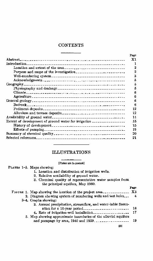
CONTENTS
PageAbstract_________________----_-____________________________ XIIntroduction. __________---__--_______________-______________ 1
Location and extent of the area_________________________________ 2Purpose and scope of the investigation.________________________ 2Well-numbering system______________________________________ 3Acknowledgments-__--------------______--____.---_-________ 5
Geography._____________________________________________________ 5Physiography and drainage________________________________ __ 5Climate. ___________ _______________________ _ 6Agriculture .... _________.___________________ _ 6
General geology ________-------------________________________ 6Bedrock________________________________ _ 6Pediment deposits.____________________________________ 12Alluvium and terrace deposits_________________________________ 12
Availability of ground water________________________________ 14Extent of development of ground water for irrigation ______________ 15
History of development.____________________________.._ 15Effects of pumping__________________________________ 19
Summary of chemical quality-_---------__________________________ 20Selected references_______________________________________ 21
ILLUSTRATIONS
[Plates are In pocket] PLATES 1-3. Maps showing:
1. Location and distribution of irrigation wells.2. Relative availability of ground water.3. Chemical quality of representative water samples from
the principal aquifers, May 1960.Page
FIGUBE 1. Map showing the location of the project area._____---_-___ X3 2. Diagram showing system of numbering wells and test holes. 4
3-4. Graphs showing:3. Annual precipitation, streamflow, and water-table fluctu
ation for a 10-year period---__-__--_-------- 164. Rate of irrigation-well installation_____________ __ 17
5. Map showing approximate boundaries of the alluvial aquifersand pumpage by area, 1940 and 1959---------_---_- - 19
m

IV CONTENTS
TABLES
Page TABLE 1. Generalized section of the geologic formations in the lower
Cache la Poudre River basin, Colorado________________ X82. Irrigation from ground-water sources in the lower Cache la
Poudre River basin in 1940 and 1959______________ 18
CONTRIBUTIONS TO THE HYDROLOGY OF THE UNITED STATES
GROUND-WATER INVESTIGATIONS IN THE LOWER CACHE LA POUDRE RIVER BASIN, COLORADO
By LLOYD A. HERSHEY and PAUL A. SCHNEIDER, JR.
ABSTRACT
Ground water is a major natural resource in the lower Cache la Poudre River basin. During periods of low precipitation and short surface-water supply, supplemental irrigation water from ground-water sources provides the needed moisture to sustain crops in this predominantly agricultural area. The lower Cache la Poudre River basin lies in northwestern Weld and northeastern Larimer Counties, Colo., and contains abdut 800 square miles of irrigated, dry-farmed, and grazing land.
Alluvial deposits overlying rocks of Late Cretaceous age constitute the prin cipal aquifers in the area. Yield from the alluvium ranges from a few gallons to 2,000 gallons per minute. Because of the availability of surface water, ground water is used principally as a supplemental irrigation supply. During periods of low surface-water supply, heavy pumping of wells substantially lowers the water table in parts of the area, but the ground-water reservoir recovers after normal precipitation has resumed.
Principal sources of recharge to the aquifers are seepage from ditches and storage reservoirs, downward percolation of applied surface water, and precipi tation.
About 86,000 acre-feet of ground water was pumped for irrigation in the lower Cache la Poudre River basin in 1959; an average of 78 acre-feet per well was applied to irrigation during the same year.
The chemical quality of ground water used for irrigation in the lower Cache la Poudre River basin has been evaluated from the analyses of 88 water samples collected during the study. Dissolved-solids content is the principal factor of evaluation for these samples. High concentrations of calcium and sulfate cause some of the water to be undesirable for irrigation use under average soil and drainage conditions. Good soil and drainage conditions and the use of surface- water reduce the hazard of applying the locally highly mineralized water to crops.
INTRODUCTION
Ground water is a major natural resource and the principal source of supplementary irrigation water in the lower Cache la Poudre Eiver basin, especially during periods of low precipitation and short sur-
XI
X2 CONTRIBUTIONS TO THE HYDROLOGY OF THE UNITED STATES
face-water supply. Ground water has also been developed for stock and domestic supplies from alluvial and bedrock aquifers. The prin cipal source of ground water for irrigation is the alluvium of the flood plain and the terrace deposits of the Cache la Poudre River and its tributaries.
Water supply for agriculture in the project area is largely depend ent on surface water. Surface water is distributed to the area by more than 30 maj or canal systems and from about 75 storage reservoirs. The canals divert water from the Cache la Poudre Eiver northwest of Fort Collins, Colo., and from various points along the stream valley. Ir rigation supplies are drawn directly from the diversion canals as needed, and some of the water is diverted to storage reservoirs.
LOCATION AND EXTENT OF THE AREA
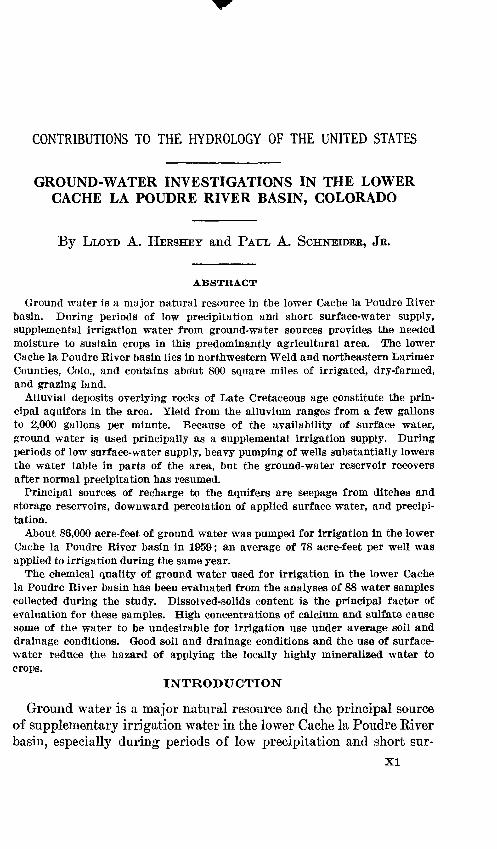
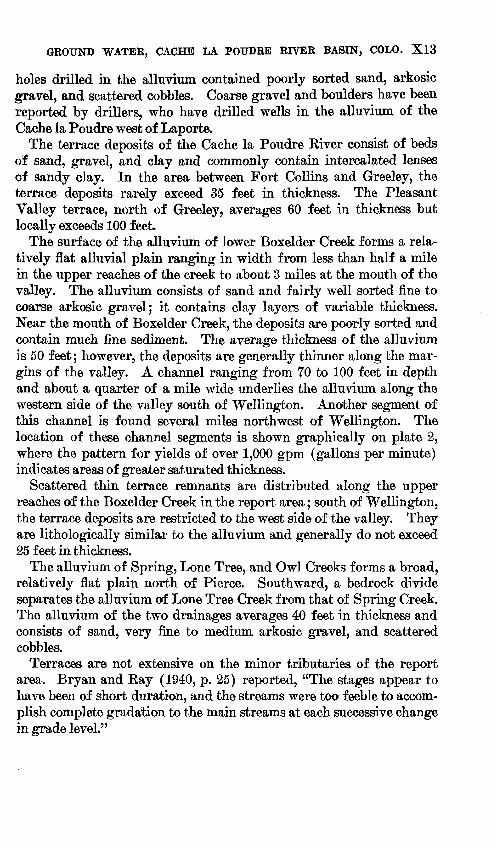
The lower Cache la Poudre Eiver basin, as defined in this report, is an area of about 800 square miles and includes parts of northwestern Weld and northeastern Larimer Counties, Colo. (fig. 1). Most of the area lies north of the lower Cache la Poudre River between La- porte, Colo., and the junction of the Cache la Poudre River with the South Platte River east of Greeley, Colo.
PURPOSE AND SCOPE OF THE INVESTIGATION
This investigation is one of a series of studies being made by the U.S. Geological Survey for the U.S. Bureau of Reclamation as a part of the program of the Department of the Interior for the development of the Missouri River basin.
Ground water has been extensively developed for irrigation in the lower Cache la Poudre River valley during the past 30 years. This study is to evaluate the present state of development and to determine hydrologic relationships within the project area. In addi tion, the chemical quality of the ground water is evaluated in terms of its suitability for crop irrigation. This report presents preliminary data on the relative availability of ground water, the extent of present development, the chemical quality of water, the hydrologic relation ships, and the critically overdeveloped areas.
Ground-water investigations in Colorado are under the direct super vision of E. A. Moulder, district engineer for Colorado. The quality- of-water investigations are under the direction of D. M. Culbertson, district engineer in charge of quality-of-water studies in the Missouri River basin.
GROUND WATER, CACHE LA POUDRE RIVER BASIN, COLO.
105°00'
41*00' WYOMING
X3
41°00'
105°00'
FIGDEB 1. Map showing the location of the project area in Larimer and Weld Counties,Colo.
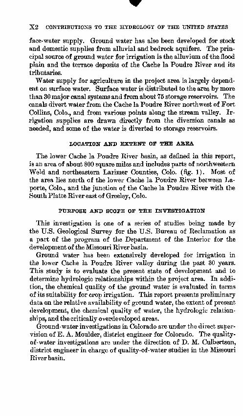
WELL-NUMBERING SYSTEM
The well numbers in the text and on the illustrations indicate well locations. The numbering system is based on the U.S. Bureau of Land Management system of land subdivision. The number shows the location of the well by quadrant, township, range, section, and position within the section. A diagram showing the method of well location is shown in figure 2. The capital letter at the beginning of the loca tion number indicates the quadrant in which the well is located. Four quadrants are formed by the intersection of the base line and the prin cipal meridian A indicates the northeast quadrant, B the northwest quadrant, C the southwest quadrant, and D the southeast quadrant. The first numeral indicates the township, the second indicates the range, and the third indicates the section in which the well is located.
X4 CONTRIBUTIONS TO THE HYDROLOGY OF THE UNITED STATES
Well B3-4-15daa
FIGURE 2. System of numbering wells and test holes in Colorado.
Lowercase letters following the section number locate the well within the section. The first letter denotes the quarter section, the second denotes the quarter-quarter section, and the third denotes the quarter- quarter-quarter section. The letters are assigned within the section in a counterclockwise direction, beginning with "a" in the northeast quarter of the section. Letters are assigned within each quarter sec tion and within each quarter-quarter section in the same manner. Where two or more wells are located within the smallest subdivision, consecutive numbers beginning with 1 are added after the letters in the order in which the wells or test holes were inventoried. For example,
GROUND WATER, CACHE LA POUDRE RIVER BASEST, COLO. X5
B6-66-29cba2 indicates a well in the northeast quarter of the north west quarter of the southwest quarter of sec. 29, T. 6 N., R. 66 W., and shows that this is the second well inventoried in the quarter-quarter- quarter section. The capital letter B indicates the township is north of the base line and that the range is west of the principal meridian.
ACKNOWLEDGMENTS
Data on water-table fluctuation were obtained from the Colorado State University Experiment Station. Records of power consumption for wells were made available by private and public utilities operating in the report area. Well owners supplied much valuable data on well performance and general information on water development. Records of the Colorado Water Conservation Board were very help ful in supplementing the well inventory. Information on soil con ditions and irrigated acreage was supplied by the Soil Conservation Service, U.S. Department of Agriculture.
GEOGRAPHY
PHYSIOGKAPHY AND DRAINAGE
The report area is a part of the Colorado Piedmont section of the Great Plains physiographic province. The area ranges in altitude from about 4,600 feet where the Cache la Poudre River joins the South Platte River in the extreme southeastern part of the area to about 5,700 feet along the western and northern uplands. The area in cludes three general types of topography: (1) dissected uplands, which are broadly rolling and in places are scarped; (2) relatively flat dis continuous uplands; and (3) valleys having nearly flat profiles.
The Cache la Poudre River is the largest tributary of the South Platte River. The lower Cache la Poudre River is the reach of the stream that flows southeastward for a distance of 32 miles from its entry of the report area at Laporte, Colo., to the confluence with the South Platte River east of Greeley, Colo. Drainage tributary to the Cache la Poudre River is principally from the north and west. Most of the minor drainages that were formerly tributary to the main- stem now terminate in irrigation canals north of the river.
Boxelder Creek is the principal tributary of the lower Cache la Poudre River; it flows southward through the project area from its point of emergence from the foothills in the northwestern part of the area for about 20 miles to the mainstem. Lower Boxelder Creek is principally an intermittent stream in its upper reaches but becomes perennial southeast of Wellington.
Lower Lone Tree, Spring, and Owl Creeks are intermittent streams that provide the principal drainage for the area north of
706-045 63 2
X6 CONTRIBUTIONS TO THE HYDROLOGY OF THE UNITED STATES
Greeley. These creeks form a complex drainage system that occupies a relatively broad valley that contains discontinuous remnants of former stream divides. Lone Tree Creek drains southeastward for about 35 miles from the point where it enters the northern project boundary to the South Platte River half a mile east of the mouth of the Cache la Poudre River. Spring Creek heads north of the proj ect boundary and drains southeastward for about 16 miles in the re port area; its drainage becomes discontinous south and east of Pierce. Owl Creek also heads north of the report area and drains southeast ward along the east margin of the tributary valley for a distance of 9 miles into Owl Creek Reservoir.
CLIMATE
The climate from the foothills west of Fort Collins to the Greeley area is characterized by low relative humidity, annual precipitation of less than 15 inches, cold winters, and warm summers. The mean annual temperature recorded at Greeley and Fort Collins is 48 °F. The first killing frost occurs about September 30 and the last killing frost about May 9. The highest recorded temperature in the area was 107 °F at Greeley in July 1936; the lowest temperature of record was -45° F at Greeley in February 1899.
Most of the precipitation in the report area occurs from April through September, but its distribution is often erratic; prolonged dry spells often occur during the growing season.
AGRICULTURE
Irrigated farming is common in the uplands and valleys served by irrigation canals. In the valley lands, north of the irrigation canals, limited irrigation is carried on with water obtained from wells. The principal crops raised on the irrigated farms are sugar beets, corn, and alfalfa. Cattle feeding also is commonly practiced in the irrigated area. North of the irrigated lands, dryland farming is practiced, and the principal crop is wheat. Livestock grazing is the predominant type of agriculture in the extreme northern part of the project area.
GENERAL GEOLOGY
BEDROCK
The bedrock formations consist chiefly of sandstone, limestone, shale, and coal of Late Cretaceous age.
The formations dip generally eastward from the foothills at the western margin of the area. Dips along the foothills range from 25° to 35°; farther east along the Larimer County line, the dips range
GROUND WATER, CACHE LA POUDRE RIVER BASIN, COLO. X7
from 3° to 6°. A reversal of dip occurs in the area north of Fort Collins, where the formations have been folded into a series of north ward-trending anticlines. The Fort Collins and Wellington oil fields are situated on these structural features. Black Hollow Field, which is located several miles east of Black Hollow Reservoir, is underlain by an anticlinal structural feature of low relief. (See Rocky Moun tain Association of Geologists, 1954, p. 102-103.) Similar low- relief structural features probably underlie the Pierce and New Wind sor oil fields but are difficult to recognize because of the mantle of slope wash and alluvial deposits.
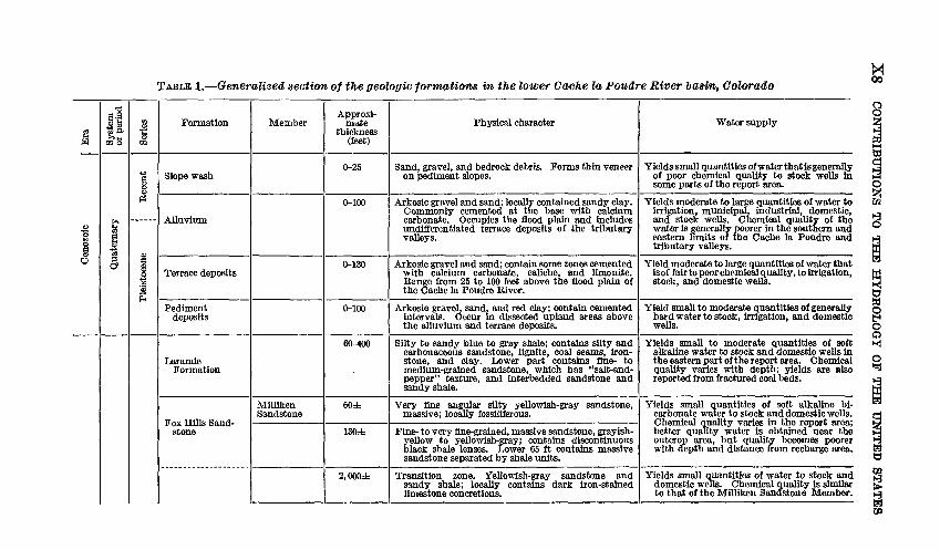
Lithology and water-bearing characteristics of the bedrock forma tions are summarized in table 1.
Sandstones of the South Platte and Lytle Formations dip steeply eastward from the mountain front and form prominent hogbacks along the western margin of the project area. These formations com pose the Dakota Group and consist of massive and lenticular sand stone, varicolored claystone, and dark-gray to black clay shale.
The Mowry Shale, Greenhorn Limestone, and the Carlile Shale over lie the Dakota Group. The thin-bedded shales and chalky limestones of these formations are less resistant to erosion than either the Dakota Group or the overlying Niobrara Formation, and thus, their area of outcrop is a valleylike depression.
The Niobrara Formation consists of chalky shales and thin-bedded chalky limestones. The basal limestone unit forms a persistent low hogback along the eastern margin of the foothills. North of Fort Collins, limestone from the Niobrara is quarried extensively for use in the manufacture of cement.
Overlying the Niobrara Formation is the Pierre Shale, which con sists of a sequence of interbedded sandy shale, mudstone, and massive to lenticular sandstone. Pediment deposits, slope wash, and alluvium cover much of the Pierre Shale in the area under study; however, standstone members are conspicuously exposed on the Wellington and Fort Collins anticlines and for several miles south of Fort Collins along U.S. Highway 287. The Pierre Shale becomes increasingly sandy in its upper part and grades into the Fox Hills Sandstone. Ex posures of this transition zone occur locally between U.S. Highway 87 and the low escarpment along the east side of Boxelder Creek valley.
The low escarpment that forms the east valley wall of the Boxelder Creek drainage is composed of fine- to medium-grained friable silty sandstone of the Fox Hills Sandstone. The sandstone is decomposed rapidly by weathering and, therefore, is poorly exposed, except where the formation has been sharply breached by artificial cuts or stream channels.
X8
CO
NT
RIB
UT
ION
S T
O T
HE
HY
DR
OL
OG
Y O
F TH
E U
NIT
ED
STA
TE
S
i°£
!*&i««-s|o1^ i g^
fllfti
52
!5£
ail553
^* 3
a ®
o S
o w
H A
c
^®
! '0
-3!
lift
<! 3
d «
Wg
sepag
pouad jo
Pierre Shale
Niobrara Forma- tlnn
Shale No. 4
Richard Sandstone
Upper sand stone and shale.
Larimer Sandstone
Lower sandstone and shale
Rocky Ridge Sandstone
Shale No. 3
Terry Sandstone
Shale No. 2
Hygiene Sandstone
Shale No. 1
Smoky Hill Marl
3,000-5,000
60-70
0-170
0-150
0-170
0-165
300-600
10-20
200-400
50-100
2,400-3,100
280±
Dark-gray shale.
Fine olive-gray sandstone, massive; contains large orange-brown calcareous concretions.
Sandy shale and thin silty sandstone.
Fine olive-gray sandstone, massive; contains brown sandy calcareous concretions and several ledge- forming sandstones.
Sandstone and shale.
Fine olive-gray sandstone, massive; contains large calcareous sandstone concretions that weather to dark-brown.
Sandy shale.
Medium yellowish-gray sandstone, thin-bedded to massive; contains fossiliferous calcareous concretions that range from 6 to 18 inches in diameter.
Shale.
Medium-grained yellowish-gray sandstone, thin- bedded to massive; contains glauconite and carbona ceous material and has "salt-and-pepper" texture.
Dark-gray shale, bentonitic; contains concretions.
Calcareous medium- to dark-gray shale, fossiliferous, speckled; contains thin bentonite streaks and marl- stone.
Yields small quantities of water of poor chemi cal quality to stock and domestic wells. Production is principally from fracture zones near the outcrop area in the western part of the report area. Water produced from this formation is high in sulfate content.
Yields small quantities of water that is generally of poor chemical quality to stock and domestic wells in the Fort Collins- Wellington area. Water has a high dissolved- scUds content and is particularly high in sulfate.
Do.
Do.
Do.
Do.
Do.
Do.
Do.
Do.
Not known to yield water to wells in the report area. May yield small quantities of water from fractures near the area of outcrop.
Do.
§O 8 H
8
I
1
CO
XlO
C
ON
TR
IBU
TIO
NS
TO
T
HE
HY
DR
OL
OG
Y O
F TH
E
UN
ITE
D
ST
AT
ES
olorado Continued
O ifOi
rOe la Poudre River>sS
to
fe§£ S00si"igc S"o^os_o"oOi
» S1sfH^
Water supplyM%1
'ft>.
af-t
|5
jjLalls
**< 5
f!a0>0"cl§SSaiJa
g
pouacl joraajsig
«a
dPfossiliferous; contains mus
deformus.
££
II
§ $
sit> CO13imestone, ma large
fossil mo
^4j °
0>
caloM
S-^»5O
"h
§11
pQ
fr*.S.S55
c? o d
.^
i-Psfl-g-a
'g
sm to yield water to wells 'ea. May
yield small qua o
wells where the sandstom becomes more
mineralized om the area of recharge.
o S (_,«
S fe -S S
o"^tS io ft
-S
55ayey sandstone. Qen- i sandy
limestone.
0 Pp
laine- to very i erally
capped
h° o3a03"3 §O
62
D
S"S 3oaa2Aoalcareous, bla(D-n<N
o"a»1D
^O1iTi to yield water to wells in 1f- ow
§o §3
J5lightly calcareous dark-1
1OJ
halky shaly li: gray
shale.
D3wia3dSfl
0)
s§S'tS
_ m
O
snoMB
jaiQ jadclfi
dP0)f-4
.a5"3 'S131ense noncalca mains.
P-HSS03O§
dPsiltstone, locally calcar- is
scattered fossiliferous sorted
quartzose sand- t
cap rocks.
shale and i jus;
contaii ained well- it
persistent
11
II
Ity gray to bis eous
and gyps zones and flni stones,
which
03S<Nft
ft
^
5S
§
ill
te oA o
to yield small quantities oi c
wells and springs
near the IB
western boundary of tt
^33
53
^S Q> bjo .
sagsC
V2r2 ^
«andstone, locally
con- bedded sandstone and irse-grained,
in places
M^8
C d .
a)-"-" <«S
'1 S
^3
ili-Medium- to coi glomeratic; coi siltstone
inter conglomeratic,
^m
§^ o
3 i
jCQaQPM
0) rt
^3
s|si
O3
dPe and degree of sorting, ,
locally conglomeratic se);
contains variegated
9 L |^g
^8§
fill
03
Sg"cla1^^snoM
Bjaio K
MO
^
sno90Biao
gg5oip2oofld
1contains grayish-white dded
limestone. Algal e common
in the lower
d
siltstone; to interbe d
cracks ai
el o> 3?£
S
ariegated shah to
white mass structure and limestones.
>SS
asfR1ij^
sslg«|
sis
sm to yield water to wells Wells
could be developed \i me
is not drained in the west* ort area.
o -S ft
H
* ^ g
§<a+s
Zto pink sandstone,
mas- >cally contains thin red
ained gray , porous; 1< se.
H,t3 c3
S«
*
ine- to mediun sive,
erossbed' sandy shale al
hJ5
cl§0303 'S
rt
l|
a «
oissBm
uaddn
oissBJnf
op*,*
Paleozoic
o
*lasPM
Triassic
1£
1 1
(Sfe-"3
p
Jelm Formation
Lykins Formation
Satanka Shale
Lyons Sandstone
Satanka Shale
Ingleside Forma tion
Fountain Forma tion
Crystalline rocks
Upper
Lower
70±
500±
130±
65±
225±
250±
300-800
Fine- to medium-grained orange to red sandstone, f massive, crossbedded, hard.
Thin-bedded dark-red sandstone and sandy shale; becomes massive toward the top.
Sandy red shale, sandstone, and siltstone; contains anhydrite and gypsiferous shale in the basal section.
Quartzose light-gray to yellowish-gray sandstone, crossbedded.
Sandy brick-red shale; contains massive and thin interbedded fine-grained pink sandstone in the lower part.
Fine-grained sandstone, massive, crossbedded; con tains some fossiliferous zones and white to gray oolitic limestone units in the upper part of the sequence.
Sandstone, arkosic conglomerate, and sandy limestone interbedded with sandy red shale; becomes more conglomeratic in the basal section.
Granite, schist, and gneiss.
Yields small quantities of water having good K 'chemical quality to domestic wells west of
Laporte, Colo.
Not known to yield water to wells in the report area.
Do.
Do.
Do.
Do.
Do.
Do. §o ft)H
ft)
ft) w
Io osM
X12 CONTRIBUTIONS TO THE HYDROLOGY OF THE UNITED STATES
Overlying the Fox Halls Sandstone are the silty lenticular sands, varicolored carbonaceous and often gypsiferous shales, and coals of the Laramie Formation. Because of its character, the formation is relatively nonresistant to erosion and is poorly exposed hi the project aera. Much of the Laramie Formation is covered by alluvium, slope wash, and pediment deposits.
PEDIMENT DEPOSITS
Several pediment surfaces underlie the uplands of the report area. These pediment surfaces were probably continuous over the entire area in the past, but only remnants now remain as gravel-capped benches or gently rolling hills. In places, the pediment deposits have been firmly cemented and form a resistant caprock. Dips of the remnants indicate that the slope of the pediment was southward from the northern boundary of the report area and eastward from the foot hills of the front range.
In the Fort Collins area, the pediment deposits consist of dark-red bentonitic clay, sand, and gravel. These deposits range in thickness from 0 to 50 feet and average about 35 feet. The water-bearing gravels are generally overlain by 1 to 30 feet of clay. Drillers' logs indicate that one gravel bed ranging in thickness from 3 to 35 feet underlies much of the area, but locally thicknesses greater than 35 feet are found.
North of Waverly, pediment deposits consist of dark-red bentonitic clay and arkosic sand and gravel. The thickness of these deposits ranges from a few feet to more than 90 feet, and the average thickness probably does not exceed 30 feet.
Pediment deposits east of Boxelder Creek generally do not exceed 15 feet in thickness and, in many places, consist of a thin cover of coarse gravel that contains many rounded cobbles and small boulders.
ALLUVIUM AND TERRACE DEPOSITS
The alluvium and terrace deposits of the Cache la Poudre River and its tributaries consist of clay, sand, and gravel, which were de rived partly from the local bedrock but mostly from the formations of the Front Range. Most of the material in the alluvium of the tributary streams has been derived from deposits of Tertiary and Pleistocene age that overlie the Upper Cretaceous bedrock north of the area.
The alluvium of the Cache la Poudre River probably does not ex ceed 80 feet in thickness and averages about 30 feet between Fort Collins and Greeley. The alluvium consists of sand, gravel, silt, and minor amounts of clay. Most of the samples of cuttings from test
GROUND WATER, CACHE LA POTTDRE RIVER BASIN, COLO. X13
holes drilled in the alluvium contained poorly sorted sand, arkosic gravel, and scattered cobbles. Coarse gravel and boulders have been reported by drillers, who have drilled wells in the alluvium of the Cache la Poudre west of Laporte.
The terrace deposits of the Cache la Poudre River consist of beds of sand, gravel, and clay and commonly contain intercalated lenses of sandy clay. In the area between Fort Collins and Greeley, the terrace deposits rarely exceed 35 feet in thickness. The Pleasant Valley terrace, north of Greeley, averages 60 feet in thickness but locally exceeds 100 feet.
The surface of the alluvium of lower Boxelder Creek forms a rela tively flat alluvial plain ranging in width from less than half a mile in the upper reaches of the creek to about 3 miles at the mouth of the valley. The alluvium consists of sand and fairly well sorted fine to coarse arkosic gravel; it contains clay layers of variable thickness. Near the mouth of Boxelder Creek, the deposits are poorly sorted and contain much fine sediment. The average thickness of the alluvium is 50 feet; however, the deposits are generally thinner along the mar gins of the valley. A channel ranging from 70 to 100 feet in depth and about a quarter of a mile wide underlies the alluvium along the western side of the valley south of Wellington. Another segment of this channel is found several miles northwest of Wellington. The location of these channel segments is shown graphically on plate 2, where the pattern for yields of over 1,000 gpm (gallons per minute) indicates areas of greater saturated thickness.
Scattered thin terrace remnants are distributed along the upper reaches of the Boxelder Creek in the report area; south of Wellington, the terrace deposits are restricted to the west side of the valley. They are lithologically similar to the alluvium and generally do not exceed 25 feet in thickness.
The alluvium of Spring, Lone Tree, and Owl Creeks forms a broad, relatively flat plain north of Pierce. Southward, a bedrock divide separates the alluvium of Lone Tree Creek from that of Spring Creek. The alluvium of the two drainages averages 40 feet in thickness and consists of sand, very fine to medium arkosic gravel, and scattered cobbles.
Terraces are not extensive on the minor tributaries of the report area. Bryan and Ray (1940, p. 25) reported, "The stages appear to have been of short duration, and the streams were too feeble to accom plish complete gradation to the main streams at each successive change in grade level."
X14 CONTRIBUTIONS TO THE HYDROLOGY OF THE UNITED STATES
AVAILABILITY OF GROUND WATER
Ground water is readily available throughout most of the report area; but because of poor chemical quality, some of the water from the bedrock aquifers is unfit for consumption by humans or stock. Most irrigation wells are in and near the principal stream valleys of the area (pi. 1).
Yields from irrigation wells in the report area range from less than 50 to as much as 2,000 gpm. The approximate yield that may be ex pected from aquifers in different parts of the area is shown on plate 2.
Wells in the immediate vicinity of Fort Collins are reported to yield an average of 15 gpm from the pediment deposits. Maximum reported yield in this area is 200 gpm from irrigation well B7-69-3cbc. The pediment deposits of the Fort Collins area are recharged prin cipally by seepage from canals and by percolation from city water applied to lawns and small gardens. Wells drilled in remnants of the pediment that are isolated from sources of recharge are generally dry.
North of Waverly, the pediment deposits yield an average of 300 gpm to irrigation wells. Locally, where the pediment deposits are thicker, yields of 400 to 800 gpm have been obtained. Where the water table is shallow and the pediment deposits are thin, sumps have been dug to bedrock and are used as a source for irrigation water. These deposits are recharged by percolation of applied irrigation water, seepage from canals and storage reservoirs, and precipitation. During years of low precipitation and short surface-water supply, most of the wells that tap the pediment gravels yield appreciably less water.
Relatively few irrigation wells have been drilled in the alluvium of the flood plain in the lower Cache la Poudre Valley, because much of the area is subject to waterlogging.
The terrace deposits of the Cache la Poudre River occur principally along the north side of the valley. The average yield of wells tapping the terrace deposits is about 300 gpm. Ground water for irrigation has been intensively developed in the Pleasant Valley area north and east of Greeley, where wells penetrate as much as 90 feet of water bearing material above the bedrock. The average yield of wells on the Pleasant Valley terrace is 700 gpm; yields of 1,300 gpm have been measured from wells located where the deposits are the thickest.
Ground water in the alluvium of Boxelder Creek valley has been intensively developed for irrigation. The average yield from irriga tion wells tapping the alluvium of this valley is about 600 gpm. Yields greater than 1,000 gpm are obtained southwest and northwest of Wellington (pi. 2). The abrupt change in yield along the west
GROUND WATER, CACHE LA POUDRE RIVER BASIN, COLO. Xl5
side of Boxelder Creek valley (pi. 2) is caused by a deep asymmetrical channel having a steep west wall.
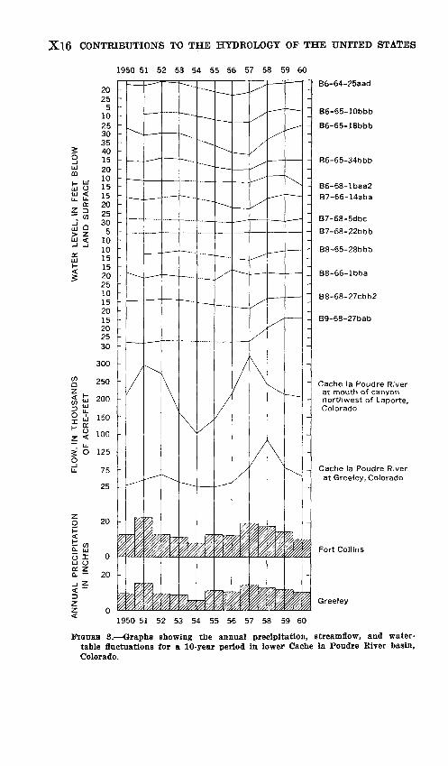
Kecharge of the Boxelder alluvium occurs by seepage from canals and reservoirs, percolation of surface water, and precipitation. Water-level fluctuations in well B9-68-27bab (fig. 3) show the influ ence of the availability of surface water on the stability of the water table.
Yields from irrigation wells in the alluvium of Spring Creek average 500 gpm. Somewhat smaller yields are obtained from the alluvium of Lone Tree Creek. The higher yields in the Spring Creek drainage may be attributed to the thicker deposits of saturated material.
North of Pierce, the alluvium is relatively thin, and yields to irri gation wells are generally less than 200 gpm. Code (1943, p. 25-26) stated:A number of attempts were made to obtain wells north of the Pierce Lateral and below the Laramie-Poudre Canal. Water ran through this canal discon- tinuously for a few years previous to 1928, but none has run since. The plants were operated a few years and then abandoned when the water table dropped 5 to 10 feet.
The four irrigation canals that cross the alluvium of Spring and Lone Tree Creeks are probably the principal source of recharge for these alluvial aquifers. Percolation of applied surface water and precipitation also recharge the alluvium. The influence of recharge from surface water on the water table is shown by the fluctuation of the water level in well B7-66-14aba (fig. 3).
Ground water is available also from the alluvium of lower Crow Creek. Yields from irrigation wells tapping the alluvium of Crow Creek range from 100 to TOO gpm.
EXTENT OF DEVELOPMENT OF GROUND WATER FORIRRIGATION
HISTORY OF DEVELOPMENT
The first irrigation well on record in the lower Cache la Poudre Kiver basin was dug reportedly east of Eaton, Colo., in 1885 by E. F. Hurdle, who later dug two other irrigation wells in the same area.1 The measured yield of one of the wells was reported to be 600 gpm. One of the wells was still in use in 1917.
A survey made during 1911-12 and reported in the "Sixteenth Biennial Eeport of the State Engineer" (Comstock, 1913) indicated that 27 wells were used for irrigation in the report area.
i Rohwer, Carl, 1953, History of Irrigation by pumping from wells in Colorado: U.S. Dept. Agriculture unpublished report, 9 p.
Xl6 CONTRIBUTIONS TO THE HYDROLOGY OF THE UNITED STATES
1950 51 52 53 54 55 56 57 58 59 60
2025
510253035401520101515202530
510101515202510152015202530
300
250
200
150
gf O 125Oi 75
25
1950 51 52 53 54 55 56 57 58 59 60
B6-64-25aad
B6-65-10bbb
B6-65-18bbb
B6-65-34bbb
B6-68- B7-66-
B7-68-
B7-68-
B8-65-
B8-66-
B8-68-
B9-68-
Ibaa2 14aba
5dbc
22bbb
28bbb
Ibba
27cbb2
27bab
Cache la Poudre River at mouth of canyon northwest of Laporte, Colorado
Cache la Poudre River at Greeley, Colorado
Fort Collins
Greeley
Fionas 3. Graphs showing the annual precipitation, streamflow, and water- table fluctuations for a 10-year period in lower Cache la Poudre River basin, Colorado.
GROUND WATER, CACHE LA POUDRE RIVER BASIN, COLO. Xl7
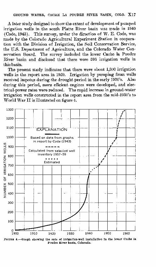
A later study designed to show the extent of development of pumped irrigation wells in the south Platte River basin was made in 1940 (Code, 1943). This survey, under the direction of W. E. Code, was made by the Colorado Agricultural Experiment Station in coopera tion with the Division of Irrigation, the Soil Conservation Service, the U.S. Department of Agriculture, and the Colorado Water Con servation Board. The survey included the lower Cache la Poudre River basin and disclosed that there were 593 irrigation wells in this basin.
The present study indicates that there were about 1,300 irrigation wells in the report area in 1959. Irrigation by pumping from wells received impetus during the drought period in the early 1930's. Also during this period, more efficient engines were developed, and elec trical-power rates were reduced. The rapid increase in ground-water irrigation wells constructed in the report area from the mid-1930's to World War II is illustrated on figure 4.
idUU
1200
1100
1000
U)IJ 900LJ
£
Z 800o
< 700
a:QL- 600LL. 0
a 500 uCD
| 400 z.
300
200
100
0 19
_
D
EXPLANATION
ased on data from grap' n report by Code (1943,
Calculated from selected well inventory 1957-59
Estimated
.- -^ -
^^^
>
/
\/ 1-
//
f
-7~~l t
,'1 t
t 1
11
00 1910 1920 1930 1940 1950 1960
FIGURE 4. Graph showing the rate of irrigation-well installation in the lower Cache la Poudre River basin, Colorado.
X18 CONTRIBUTIONS TO THE HYDROLOGY OF THE UNITED STATES
The latest well inventory indicated that fewer than 100 wells were drilled in the report area between 1941 and 1945. After World War II, the installation of irrigation wells continued at a constant rate until the dry spell of 1954-56; during this period, the rate of drilling and installation of irrigation wells increased markedly. By 1958, the rate of installation of new wells had leveled off, and the drilling of replace ment wells was the principal activity in the report area through 1958 and 1959.
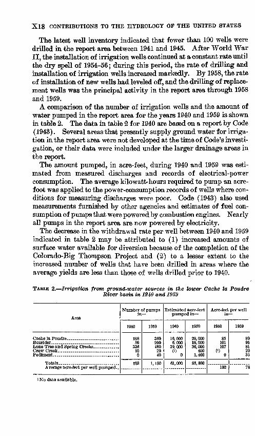
A comparison of the number of irrigation wells and the amount of water pumped in the report area for the years 1940 'and 1959 is shown in table 2. The data in table 2 for 1940 are based on a report by Code (1943). Several areas that presently supply ground water for irriga tion in the report area were not developed at the tune of Code's investi gation, or their data were included under the larger drainage areas in the report.
The amount pumped, in acre-feet, during 1940 and 1959 was esti mated from measured discharges and records of electrical-power consumption. The average kilowatt-hours required to pump an acre- foot was applied to the power-consumption records of wells where con ditions for measuring discharges were poor. Code (1943) also used measurements furnished by other agencies and estimates of fuel con sumption of pumps that were powered by combustion engines. Nearly all pumps in the report area are now powered by electricity.
The decrease in the withdrawal rate per well between 1940 and 1959 indicated in table 2 may be attributed to (1) increased amounts of surface water available for diversion because of the completion of the Colorado-Big Thompson Project and (2) to a lesser extent to the increased number of wells that have been drilled in areas where the average yields are less than those of wells drilled prior to 1940.
TABLE 2. Irrigation from ground-water sources in the lower Cache la Poudre River lasvn, in 1940 and 1959
Area
Cache la Poudre ______________Boxelder.. ____ _____________Lone Tree and Spring Creeks _______
Pediment- ________________
Average acre-feet per well pumped..
Number of pumps in
1940
188 59
336 10 0
593
1959
360 200 480 20 40
1,100
Estimated acre-feet pumped in
1940
16,000 6,000
39,000("o
61,000
1959
29,000 19,000 36,000
400 1,400
85,800
Acre-feet per well in
1940
85 101 107
(') 0
102
1959
SO 95 81 20 35
78
i No data available.
GROUND WATER, CACHE LA POUDRE RIVER BASEST, COLO. Xl9
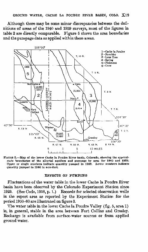
Although there may be some minor discrepancies between the defi nitions of areas of the 1940 and 1959 surveys, most of the figures in table 2 are directly comparable. Figure 5 shows the area boundaries and the pumpage data as applied within these areas.
105°00'
T. 10 N.
1 - Cache la Poudre 2-Boxelder 3 - Lone Tree 4-Spring 5 - Pediment 6-Crow
T. 9 N.
40°30'
5
I
R. 67 W.
0
I . , > 1
R. 66 W.
51
R. 65 W.
10 MILES1
104°30 r
R. 64 w.
FIGURE 5. Map of the lower Cache la Poudre River basin, Colorado, showing the approxi mate boundaries of the alluvial aquifers and pumpage by area for 1940 and 1959. Upper or single numbers indicate quantity pumped in 1959. Lower numbers indicate quantity pumped in 1940 in acre-feet.
EFFECTS OF PUMPING
Fluctuations of the water table in the lower Cache la Poudre Kiver basin have been observed by the Colorado Experiment Station since 1929. (See Code, 1958, p. 1.) Kecords for selected observation wells in the report area as reported by the Experiment Station for the period 1950-60 are illustrated on figure 3.
The water table in the lower Cache la Poudre Valley (fig. 5, area 1) is, in general, stable in the area between Fort Collins and Greeley. Eecharge is available from surface-water sources or from applied ground water.
X20 CONTRIBUTIONS TO THE HYDROLOGY OF THE UNITED STATES
The greatest concentration of irrigation wells in the Boxelder Creek valley (fig. 5, area 2) is south of Wellington, where wells range in number from 3 to 11 per section. The heavy concentration of withdrawals has caused a lowering of the water table locally and a substantial decline in yields. The water table near Wellington has fluctuated considerably; Code (1958, p. 13) reported that "the lands in this area are under a canal that has suffered from short water supplies for some time. In consequence, there have been many wells drilled in the past 20 years, and the draft has exceeded replenishment much of the time." Abundant surface water during 1957 and 1958 has recharged the ground-water reservoir effectively in this area. However, during an extensive drought that requires total dependency on ground water for irrigation, lowering of the water table would spread southward toward the mainstem. South of Wellington, where other canals with perennially large supplies of surface water cross the valley, the water table is subject to less fluctuation.
In the Lone Tree and Spring Creek valleys (fig. 5, areas 3 and 4), the water-table fluctuations can generally be correlated with the amounts of surface water south of the Pierce Lateral. The water table in these valleys has declined locally as much as 15 feet because of increased pumping during periods of short surface-water supply, but it has recovered when surface-water supplies were restored to normal and pumping was reduced.
SUMMARY OF CHEMICAL QUALITY
The chemical quality of ground water used for irrigation in the lower Cache la Poudre River basin is evaluated from analyses of 88 water samples collected during the study. The location and prin cipal chemical constituents of representative samples are shown by the use of Stiff diagrams (Stiff, 1951) in plate 3. The Stiff diagrams show relative concentrations (in equivalents per million) of calcium, magnesium, and sodium, which are plotted to the left of an ordinate on three separate abscissas; concentrations of bicarbonate, sulfate, and chloride are similarly plotted to the right of the ordinate. The dia grams have a distinctive shape that depends on the type of water. The size of the area enclosed indicates the concentration of dissolved solids. By comparing the area of diagrams in the upper and lower parts of the drainages in plate 3, it becomes readily apparent that the dissolved-solids content generally increases downgradient and that the chemical character of the water changes markedly.
The chemical analyses of water samples collected from aquifers in the report area are given in table 5 of Colorado ground water basic- data report No. 8 (Schneider and Hershey, 1961). Chemical constit-
GROUND WATER, CACHE LA POUDRE RIVER BASIN, COLO. X21
uents in the basic-data report are reported in parts per million. A part per million is a unit weight of a constituent in a million unit weights of water. An equivalent per million is a unit chemical com bining weight of a constituent in a million unit weights of water and is calculated by dividing the concentration in parts per million by the chemical combining weights of the constituent. For convenience in making this conversion, the reciprocals of chemical combining weights of the most commonly reported constituents are given in the following list:Constituent Factor Calcium (Ca++ )________ 0.04990 Magnesium (Mg++)_______ .08226 Sodium (Na+ )__________ .04350 Potassium (K+)________ .02557 Carbonate (C<V~)_______ .03333
Constituent Factor
Bicarbonate (HCO3")____ 0.01639 Sulfate (SO*")________ .02082 Chloride (Cl')__________ .02821 Fluoride (F')__________ .05264 Nitrate (N<V)__________ .01613
Much of the ground water, particularly in the lower reaches of the tributary valleys, contains dissolved solids in amounts prohibitive to irrigation under normal conditions (U.S. Salinity Lab. Staff, 1954, p. 69-82). However, on well-drained sandy soils alternate heavy applications of good-quality surface water and applications of poorer quality ground water prevent concentration of the salts in the soils.
In times of deficient supplies of surface water and increased de pendency on ground water, the high salinity hazard (U.S. Salinity Lab. Staff, 1954, p. 29) of the applied ground water may be expected to cause the soils to become saline and crop yields to decline. A pro nounced increase in calcium and sulfate salts is a principal cause for the increase in the dissolved-solids content. Slope washing of the bedrock that contains gypsiferous shales or local concentrations of gypsum and reuse of ground water probably are the principal factors contributing to the increase in dissolved solids in the ground water. Locally, high concentrations of magnesium also occur.
The quality of water, for use in irrigation, is based principally on three characteristics: (1) dissolved solids, (2) sodium-adsorption- ratio (SAE), and (3) concentration of boron (U.S. Salinity Lab. Staff, 1954, p. 75). Classification of irrigation waters in this report is based on the assumption that conditions are normal in relation to soil texture, infiltration rate, drainage, quantity of water applied, climate, and tolerance of crop.
SELECTED REFERENCES
Bittinger, M. W., 1959, Colorado's ground-water problems: Colorado State Univ.Expt. Sta. Bull. 504-S, 28 p.
Bryan, Kirk, and Bay, L. L., 1940, Geologic antiquity of the Lindenmeier sitein Colorado: Smithsonian Misc. Colln., v. 90, no. 2, 76 p., 7 pis., 12 figs.
X22 CONTRIBUTIONS TO THE HYDROLOGY OF THE UNITED STATES
Code, W. E., 1943, Use of ground water for irrigation in the South Platte Vallej of Colorado: Colorado Agr. Expt. Sta. Bull. 483, 43 p., 17 figs.
1958, Water table fluctuations in eastern Colorado: Colorado Agr. Expt. Sta. Bull. 500-S, 34 p., 17 pis., 3 flgs.
Colorado Water Conservation Board and Colorado A & M College, 1952, A hundred years of irrigation in Colorado: p. 31-40.
Comstock, C. W., 1913, Sixteenth biennial report of the State Engineer's oflice to the Governor of Colorado for the years 1911-1912: Denver, Colo., Smith- Brooks Printing Co., 363 p.
Hem, J. D., 1959, Study and interpretation of the chemical characteristics ot natural water: U.S. Geol. Survey Water-Supply Paper 1473, 269 p., 2 pis., 40 figs.
Rocky Mountain Association of Geologists, 1954, Oil and gas fields of Colorado: p. 102-103.
Schneider, P. A., Jr., and Hershey, L. A., 1961, Records and logs of selected wells and test holes, and chemical analyses of ground water in the lower Cache la Poudre River basin, Colorado: Colorado Water Oonserv. Board Basic-Data Rept no. 8, Ground Water Ser., 63 p., 1 pi., 1 fig.
Stiff, H. A., Jr., 1951, The interpretation of chemical water analysis by means of patterns: Jour. Petroleum Technology, p. 15-17.
Sweet, A. T., Brown, L. A., and Haines, W. E., 1932, Soil survey of the Greeley area, Colorado: U.S. Dept. Agriculture, Soil Survey Rept. 1929, no. 5, 30 p., 4 pis.
U.S. Bureau of Reclamation, 1959, Report on the South Platte River basin: p. 209-211.
U.S. Salinity Laboratory Staff, 1954, Diagnosis and improvement of saline and alkali soils: U.S. Dept. Agriculture Handb. no. 60,160 p.
Wilcox, L. V., 1948, The quality of water for irrigation use: U.S. Dept. Agricul ture Tech. Bull. 962,40 p.
O