Embed Size (px)
Citation preview

Gridspec: A standard for the description of gridsused in Earth System models
GO-ESSP Workshop 2008Seattle WA
V. Balaji1 Zhi Liang2 Alistair Adcroft1
1Princeton University
2HPTi Inc.
17 September 2008
Balaji et al (NOAA/GFDL) Mosaic Gridspec 17 September 2008 1 / 26

Talk outline. . .1 Examples of grids in use in ESMs
Horizontal coordinatesVertical coordinates
2 Why a grid standard?Model makersModel data users
3 The GridspecGeometryMosaics and tilesSupergrids
4 Gridspec implementations5 Gridspec tools
Grid creationRegriddingAnalysis and Visualization
6 Outstanding issues
Balaji et al (NOAA/GFDL) Mosaic Gridspec 17 September 2008 2 / 26

Talk outline . . .1 Examples of grids in use in ESMs
Horizontal coordinatesVertical coordinates
2 Why a grid standard?Model makersModel data users
3 The GridspecGeometryMosaics and tilesSupergrids
4 Gridspec implementations5 Gridspec tools
Grid creationRegriddingAnalysis and Visualization
6 Outstanding issues
Balaji et al (NOAA/GFDL) Mosaic Gridspec 17 September 2008 3 / 26

Horizontal grids in use in ESMs
Balaji et al (NOAA/GFDL) Mosaic Gridspec 17 September 2008 4 / 26
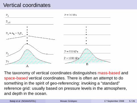
Vertical coordinates
The taxonomy of vertical coordinates distinguishes mass-based andspace-based vertical coordinates. There is often an attempt to dosomething in the spirit of geo-referencing: invoking a “standard”reference grid: usually based on pressure levels in the atmosphere,and depth in the ocean.
Balaji et al (NOAA/GFDL) Mosaic Gridspec 17 September 2008 5 / 26

Talk outline . . .1 Examples of grids in use in ESMs
Horizontal coordinatesVertical coordinates
2 Why a grid standard?Model makersModel data users
3 The GridspecGeometryMosaics and tilesSupergrids
4 Gridspec implementations5 Gridspec tools
Grid creationRegriddingAnalysis and Visualization
6 Outstanding issues
Balaji et al (NOAA/GFDL) Mosaic Gridspec 17 September 2008 6 / 26

Earth system models are built from components
Earth system models nowadays are builtfrom components: subsystems that maybe independently discretized.
Even when all components are built by acohesive community, the differentcomponents must have some conventionsto share grid information.
Furthermore, these days it is increasinglycommon to build ESMs out of componentsof independent provenance.
Balaji et al (NOAA/GFDL) Mosaic Gridspec 17 September 2008 7 / 26

Dependencies across data from many models
Model intercomparisons havebecome a primary researchavenue for consensus anduncertainty estimates ofanthropogenic climate change.This plot is a compositeacross the entire AR4 archive.
Model chaining: output fromone model used as forcing foranother “downstream”.
Balaji et al (NOAA/GFDL) Mosaic Gridspec 17 September 2008 8 / 26

Grid metadata
To be of use by models as well as for interpreting model output, thestandard must enable vector calculus and conservative regridding.The following aspects of a grid must be included in the specification:
distances between gridpoints, to allow differential operations;
angles of grid lines with respect to a reference, usually geographicEast and North, to enable vector operations. One may alsochoose to include an arc type (e.g “great circle”), which specifiesfamilies of curves to follow while integrating a grid line along asurface.
areas and volumes for integral operations. This is generally doneby defining the boundaries of a grid cell represented by a pointvalue. Below we will also consider fractional areas and volumes inthe presence of a mask, which defines the sharing of cell betweentwo or more components.
Balaji et al (NOAA/GFDL) Mosaic Gridspec 17 September 2008 9 / 26

Talk outline . . .1 Examples of grids in use in ESMs
Horizontal coordinatesVertical coordinates
2 Why a grid standard?Model makersModel data users
3 The GridspecGeometryMosaics and tilesSupergrids
4 Gridspec implementations5 Gridspec tools
Grid creationRegriddingAnalysis and Visualization
6 Outstanding issues
Balaji et al (NOAA/GFDL) Mosaic Gridspec 17 September 2008 10 / 26

Geometry and coordinate systems
The underlying geometry: sphere, spheroid, geoid, plane. . . Ingeneral transformations between different geometries are notwell-defined.
“Sphere” geometries permit geo-referencing: mapping to“canonical” coordinates: geographic longitude and latitude.
Vertical geometry: mass- or space-based. Again, transformationsbetween these are not well-posed, or must be user-definedfunctions.
Analogue of geo-referencing is community-defined standardmodel levels.
Vertical coordinates may need terrain information: referencesurface is a digital elevation map of the planetary surface.(Dependency on external dataset).
Balaji et al (NOAA/GFDL) Mosaic Gridspec 17 September 2008 11 / 26

Projections
polar_stereographic , lambert_conformal , mercator ,none , etc.
May need auxiliary information: e.g north_pole attribute that isnot the geographic North Pole. (a “rotated pole” is not a mappingor a projection but an attribute!)
Sometimes stored under grid_mapping .
The tripolar grid of Murray (1996) is composedof tiles with different projections: two polarstereographic projections with different poles,and a spherical coordinate system below thepolar latitude.
Balaji et al (NOAA/GFDL) Mosaic Gridspec 17 September 2008 12 / 26

Discretizations
Discretization expresses how to represent coordinate space in arrays.
The most commonly used discretization in Earth system scienceis logically rectangular.A discretization is logically rectangular if the coordinate space(x, y, z) is translated one-to-one to index space (i,j,k) . Notethat the coordinate space may continue to be physicallycurvilinear; yet, in index space, grid cells will be rectilinear boxes.The discretization is regular if in addition we can constructcoordinate arrays x(i) , y(j) , z(k) .
Triangular discretizations (and often, irregular LRGs) are oftenexpressed as unstructured grids (x(i) , y( i ) , z(k) ).
Mappings are methods of recovering coordinate locations from afunctional form based on the discretization. The current CFgrid_mapping does that, but also seems to be a container forprojection information.
Balaji et al (NOAA/GFDL) Mosaic Gridspec 17 September 2008 13 / 26

Mosaics
The mosaic is a simple but powerful abstraction that allows one tocleanly express complex grids as collections of tiles.
Starting with a simple grid tile. . .
you can make a simple mosaic. . .
add refinement. . .
Balaji et al (NOAA/GFDL) Mosaic Gridspec 17 September 2008 14 / 26

Mosaics
The mosaic is a simple but powerful abstraction that allows one tocleanly express complex grids as collections of tiles.
Starting with a simple grid tile. . .
you can make a simple mosaic. . .
add refinement. . .
Balaji et al (NOAA/GFDL) Mosaic Gridspec 17 September 2008 14 / 26

Mosaics
The mosaic is a simple but powerful abstraction that allows one tocleanly express complex grids as collections of tiles.
Starting with a simple grid tile. . .
you can make a simple mosaic. . .
add refinement. . .
Balaji et al (NOAA/GFDL) Mosaic Gridspec 17 September 2008 14 / 26
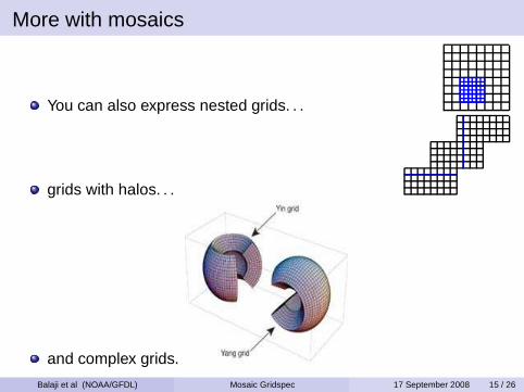
More with mosaics
You can also express nested grids. . .
grids with halos. . .
and complex grids.
Balaji et al (NOAA/GFDL) Mosaic Gridspec 17 September 2008 15 / 26

Contact regions
The connection between the tiles in the mosaic is either aboundary or an overlap.
Boundary specification: anchor points, orientations.
Overlap specification: exchange grid. Also where to resolvemasks (e.g the land-sea boundary).
Land Ocean Exchange
L
L L L
Since mosaics are recursive, we can specify a complete coupledmodel. . .
Balaji et al (NOAA/GFDL) Mosaic Gridspec 17 September 2008 16 / 26

Staggering and supergrids
sT sT sT sT-U6V
s6U-V
s6U-V
s6U-V
s6U-V
s-U s-U
s6V
s6V
s6V
s6V
s-U
s-U
A B C D
If the “staggered” quantities are placed on independent coordinatesets (x, y), (xu , yu), (xv, yv) their relationships are lost.
We instead define the supergrid: the set of all the points on thegrid where physical quantities might be defined.
Variables are defined on subsets of points on the supergrid.
Balaji et al (NOAA/GFDL) Mosaic Gridspec 17 September 2008 17 / 26
Talk outline . . .1 Examples of grids in use in ESMs
Horizontal coordinatesVertical coordinates
2 Why a grid standard?Model makersModel data users
3 The GridspecGeometryMosaics and tilesSupergrids
4 Gridspec implementations5 Gridspec tools
Grid creationRegriddingAnalysis and Visualization
6 Outstanding issues
Balaji et al (NOAA/GFDL) Mosaic Gridspec 17 September 2008 18 / 26

Implementations of Gridspec
The Gridspec is to some degree language-neutral: if netCDF-3,then it can be entirely done in netCDF-3. Current implementationsinclude the GENIE Implementation in XML (Ian Henderson:http://www.genie.ac.uk ) and the GFDL implementation (ZhiLiang: http://www.gfdl.noaa.gov/˜vb/grids ).
It can be expressed in various data formats as well as in XMLschema: we are still hedging our bets as to whether this will getput in netCDF files or in some “aggregation layer”.
So. . . it’s nice to see that the two prototype implementations are inXML and netCDF-3. . .
Balaji et al (NOAA/GFDL) Mosaic Gridspec 17 September 2008 19 / 26

Talk outline . . .1 Examples of grids in use in ESMs
Horizontal coordinatesVertical coordinates
2 Why a grid standard?Model makersModel data users
3 The GridspecGeometryMosaics and tilesSupergrids
4 Gridspec implementations5 Gridspec tools
Grid creationRegriddingAnalysis and Visualization
6 Outstanding issues
Balaji et al (NOAA/GFDL) Mosaic Gridspec 17 September 2008 20 / 26

Specifying a grid tile
A command-line tool for creating a horizontal grid file forhorizontal_grid_type = spectral_grid,regular_lonlat_grid, tripolar_grid,conformal_cubic_grid, gnomonic_cubic_grid,simple_cartesian_grid , e.g
make_hgrid -grid_type regular_lonlat_grid -nlon0,1,3,...360 -nlat -90,-88.2,... creates a lat-lon gridwith non-uniform spacing.
make_hgrid -grid_type conformal_cubic_grid -nlon48 -nratio 2 : created 48 × 48 × 6 cubic grid.
A similar tool called make_vgrid for vertical grids.
Balaji et al (NOAA/GFDL) Mosaic Gridspec 17 September 2008 21 / 26

Specifying mosaics
make_solo_mosaic -num_tiles ntiles -tile_filegridtilewill look for a set of ntiles tile gridspec netCDF files namedgridtile#.nc and make a mosaic file mosaic.nc thatspecifies their linkages.make_topog -mosaic mosaic.nc -topog_typerealistic -topog_file/archive/fms/mom4/input_data/OCCAM_p5degree.nc-topog_field TOPOspecifies the topography/bathymetry.make_coupler_mosaic -atmos_mosaic atm_mosaic.nc-ocean_mosaic ocean_mosaic.nc -ocean_topogocean_topog.nc [-land_mosaic land_mosaic.nc][-sea_level sea_level] [-interp_method 1][-mosaic_name mosaic_name] generates a coupler mosaicwith land-sea mask, etc.
Balaji et al (NOAA/GFDL) Mosaic Gridspec 17 September 2008 22 / 26
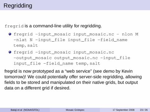
Regridding
fregrid is a command-line utility for regridding.
fregrid -input_mosaic input_mosaic.nc - nlon M-nlat N -input_file input_file -field_nametemp,salt
fregrid -input_mosaic input_mosaic.nc-output_mosaic output_mosaic.nc -input_fileinput_file -field_name temp,salt
fregrid is now prototyped as a “web service” (see demo by Kevintomorrow)! We could potentially offer server-side regridding, allowingfields to be stored and manipulated on their native grids, but outputdata on a different grid if desired.
Balaji et al (NOAA/GFDL) Mosaic Gridspec 17 September 2008 23 / 26

Analysis and visualization
ferret , a widely-used analysis and plotting utility is now capableof interpreting gridspec files and displaying the associated mosaicdatasets. A “native” capability within ferret is being built.http://www.gfdl.noaa.gov/˜atw/ferret/cubed_sphere/
The MoDAVEproject funded by DoE is building mosaicvisualization capability within the VisIT tool, to be demo’d by AlexPletzer of Tech-X tomorrow.
Balaji et al (NOAA/GFDL) Mosaic Gridspec 17 September 2008 24 / 26

Talk outline . . .1 Examples of grids in use in ESMs
Horizontal coordinatesVertical coordinates
2 Why a grid standard?Model makersModel data users
3 The GridspecGeometryMosaics and tilesSupergrids
4 Gridspec implementations5 Gridspec tools
Grid creationRegriddingAnalysis and Visualization
6 Outstanding issues
Balaji et al (NOAA/GFDL) Mosaic Gridspec 17 September 2008 25 / 26

Outstanding issues
There is no agreed-upon method for remapping of vector fields:this is still an open research question. In particular for CMIP-5, thequestion of defining “poleward transport” for ocean models withnon-spherical native grids is unresolved.Gridspec is still not in the “CF process”. This is mostly my fault:some of this stems from my uncertainty as to how to proceed.Perhaps “standardizing” the tools and APIs would be a start?Especially the ability to read mosaics into web services andESMF/PRISM data structures. . .Handling of Gridspec as an external reference: CF still doesn’t dothis cleanly. e.g in CMIP-3: sea_cell_area andocean_cell_volume are stored in the static table andreferenced in the 2D and 3D tables through free-text commentattributes.Unstructured grids have special issues, and should be a separatebut coordinated track.
Balaji et al (NOAA/GFDL) Mosaic Gridspec 17 September 2008 26 / 26