Embed Size (px)
Citation preview

Spartanburg County Storm Water Management Design Manual
Spartanburg County, South Carolina March 16, 2009 Storm Water Management Design Manual
i
TABLE OF CONTENTS Section Title Page No. Table of Contents ......................................................................................................................................... i List of Tables ………………………………………………………………………………………...…...iii Chapter 1 Introduction......................................................................................................................... 1
1.1 Purpose of the Manual .................................................................................................................. 1 1.2 Description and Use of the Manual............................................................................................... 1
1.2.1 Innovative Design Approach ................................................................................................ 1 1.2.2 Best Site Design Practices and Site Planning Process .......................................................... 2
1.3 Storm Water Management Regulations and Policies.................................................................... 2 1.3.1 NPDES Stormwater Permits ................................................................................................. 2 1.3.2 Local Ordinances - Storm Water Management Ordinance ................................................... 4
1.4 Contact Information ...................................................................................................................... 5 Chapter 2 Storm Water Management Requirements and Standards.............................................. 6
2.1 Overview....................................................................................................................................... 6 2.2 Minimum Requirements for Development ................................................................................... 6
2.2.1 Applicability ......................................................................................................................... 6 2.2.2 Exemptions ........................................................................................................................... 7 2.2.3 Notice of Termination........................................................................................................... 8 2.2.4 Waivers and Variances.......................................................................................................... 8 2.2.5 Additional Requirements ...................................................................................................... 9
Chapter 3 Plan Submittal ................................................................................................................... 10
3.1 Storm Water Management Planning ........................................................................................... 10 3.1.1 Purpose................................................................................................................................ 10 3.1.2 Steps for Successful Storm Water Management Plans ....................................................... 10
3.2 Submittal Requirements for Sites With Greater Than 5,000 Sq Ft of Disturbed Acre ............... 11 3.2.1 Applications ........................................................................................................................ 11 3.2.2 Permits ................................................................................................................................ 11 3.2.3 Storm Water Management Design Standards ..................................................................... 12 3.2.4 Special Flood Hazard Area ................................................................................................. 12 3.2.5 Storm Water Facility Ownership and Maintenance ............................................................ 12
3.3 Plan Submittal, Review and Approval Process........................................................................... 13 3.3.1 Plan Submittal ..................................................................................................................... 13 3.3.2 Plan Review Period............................................................................................................. 13 3.3.3 Incomplete Storm Water Management Permit Applications .............................................. 13 3.3.4 Plan Approval and Final Submittal ..................................................................................... 14
3.4 Construction Requirements......................................................................................................... 14 3.4.1 Deviations from Approved Plans ........................................................................................ 14 3.4.2 As-Built Requirements........................................................................................................ 15
3.5 Application Fees ......................................................................................................................... 15 Chapter 4 Easements .......................................................................................................................... 16
4.1 Purpose........................................................................................................................................ 16 4.2 Existing Easements ..................................................................................................................... 16 4.3 Temporary Construction Easements ........................................................................................... 16
4.4 Easement Widths ........................................................................................................................ 16 Chapter 5 Hydrology .......................................................................................................................... 18
5.1 Introduction................................................................................................................................. 18 5.2 Computational Standard Methods............................................................................................... 18
5.2.1 Recommended Methodologies............................................................................................ 18 5.3 Rainfall and Intensities................................................................................................................ 19
Chapter 6 Hydraulics.......................................................................................................................... 23
6.1 Open Channel Hydraulics ........................................................................................................... 23 6.2 Hydraulics of Culverts ................................................................................................................ 23 6.3 Storm Drainage Design Requirements........................................................................................ 24
6.3.1 Storm Drainage Systems..................................................................................................... 24 Chapter 7 Stormwater Detention Design and Downstream Analysis............................................. 28
7.1 Hydrologic and Hydraulic Design Criteria ................................................................................. 28 7.1.1 Accepted Detention Structural Controls ............................................................................. 29
7.2 Design Procedures ...................................................................................................................... 30 7.2.1 Freeboard ............................................................................................................................ 30
7.3 Downstream Analysis ................................................................................................................. 31 7.3.1 Downstream Analysis Limits.............................................................................................. 31 7.3.2 Downstream Analysis Design Storm Events ...................................................................... 31 7.3.3 Downstream Analysis Criteria ............................................................................................ 32 7.3.4 Improvement Options ......................................................................................................... 32
7.4 Limited Construction Areas Chapter 8 Erosion and Sediment Control......................................................................................... 34
8.1 Introduction................................................................................................................................. 34 8.2 Erosion Protection and Sediment Control Requirements............................................................ 34
8.2.1 EPSC Development Standards............................................................................................ 34 8.2.2 Alternative Erosion Prevention and Sediment Control BMPs ............................................ 34
8.3 Runoff Control and Conveyance Measures ................................................................................ 35 8.4 Report Development ................................................................................................................... 35
Chapter 9 Water Quality.................................................................................................................... 37
9.1 Anti-degradation Rules for Impaired Waters .............................................................................. 37 9.1.1 Impaired Waterbodies ......................................................................................................... 37 9.1.2 Applicability ....................................................................................................................... 37 9.1.3 Water Quality Impairment .................................................................................................. 37 9.1.4 Total Maximum Daily Loads (TMDLs) ............................................................................. 38
9.2 Water Quality Design Criteria .................................................................................................... 38 9.3 Water Quality BMPs................................................................................................................... 39
Chapter 10 Stream Protection and Restoration ................................................................................. 41
10.1 Stream Buffers ............................................................................................................................ 41 10.2 Streambank Stabilization ............................................................................................................ 42
Chapter 11 References ......................................................................................................................... 44
Spartanburg County, South Carolina March 16, 2009 Storm Water Management Design Manual
ii
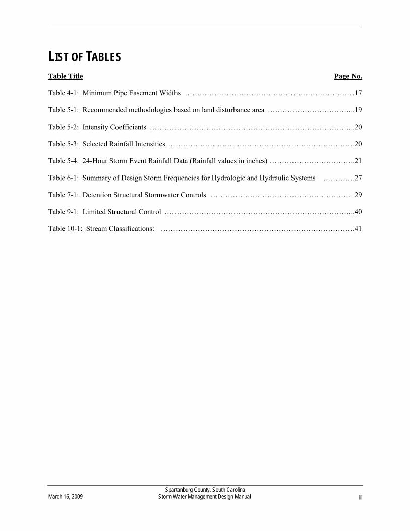
LIST OF TABLES Table Title Page No. Table 4-1: Minimum Pipe Easement Widths ……………………………………………………………17 Table 5-1: Recommended methodologies based on land disturbance area ……………………………...19 Table 5-2: Intensity Coefficients ………………………………………………………………………...20 Table 5-3: Selected Rainfall Intensities ………………………………………………………………….20 Table 5-4: 24-Hour Storm Event Rainfall Data (Rainfall values in inches) ……………………………..21 Table 6-1: Summary of Design Storm Frequencies for Hydrologic and Hydraulic Systems ………….27 Table 7-1: Detention Structural Stormwater Controls …………………………………………………. 29 Table 9-1: Limited Structural Control …………………………………………………………………...40 Table 10-1: Stream Classifications: …………………………………………………………………….41
Spartanburg County, South Carolina March 16, 2009 Storm Water Management Design Manual
iii
Spartanburg County, South Carolina March 16, 2009 Storm Water Management Design Manual
1
CHAPTER 1 INTRODUCTION
1.1 Purpose of the Manual
The purpose of this Storm Water Management Design Manual is to provide practical information on the subjects of storm water management and sediment control associated with land disturbing activities in Spartanburg County, South Carolina. This manual, when used in conjunction with the Spartanburg County Storm Water Management and Sediment Reduction Regulations, is an important tool to protect Spartanburg County’s soil and water resources by providing a consistent framework for the development of storm water management plans.
1.2 Description and Use of the Manual
The design manual was developed under the assumption that the user possesses a basic understanding of storm water control design, construction, or land development depending on the user’s particular area of expertise. Users of this manual who are not justly qualified by education or experience in the fields of storm water control design, construction, or land development should consult with a qualified professional in one or more of these areas prior to adhering to the requirements contained within the manual. This manual is not intended to be a systematic design methodology that addresses every land development situation that may occur in Spartanburg County. The application of engineering principles and judgment combined with the information contained within this manual are required to successfully complete the planning, design, and preparation of documents for storm water management plan submittal. This manual is not intended to restrain or inhibit engineering creativity, freedom of design, or the need for engineering judgment. When shown to be applicable, it is encouraged that new procedures, techniques, and innovative storm water BMPs be submitted with supporting documentation. The documentation submitted by design professionals should show that these procedures are equal to, or exceed the procedures and/or controls contained in this design manual.
1.2.1 Innovative Design Approach
When designing for maximum water quantity, erosion prevention, sediment control, and water quality benefits, the design professional should take the following considerations in mind:
Storm water quantity and quality are best controlled at the source of the problem by reducing the
potential maximum amount of runoff and pollutants; and
Best site design techniques implement storm water management by using simple, nonstructural methods along with or in place of traditional storm water management structures when applicable.
Innovative approaches to site design are more of a source control for storm water runoff – the site design practices limit the amount of runoff generated as well as use certain BMPs within the design. These types of design concepts are described in detail in several sources including: Georgia Storm Water Manual, Volume 1: Policy Guidebook, First Edition, Atlanta Regional Commission, August 2001; and, Low-Impact Development Design Manual, Prince George’s County Maryland, Department of Environmental Resources, November 1997. Some general concepts from these sources are provided in the following sections.
1.2.2 Best Site Design Practices and Site Planning Process
The first step in addressing storm water management begins in the site planning and design stage of the development project. By implementing Best Site Design Practices during the site planning process, the amount of runoff and pollutants generated from a site can be reduced by minimizing the amount of impervious area and utilizing natural on-site treatments. The minimizing of adverse storm water runoff impacts by the use of Best Site Design Practices and site planning should be a major consideration for a design professional. The reduction of runoff volumes and storm water pollutants reduces the total number and size of storm water management controls that must be implemented under the guidelines set forth in this design manual. Best Site Design Practices reduce the amount of total post-development impervious areas and maintains natural characteristics of the pre-development site conditions. Therefore, the post-development curve number and time of concentrations are maintained more closely to the pre-development conditions, which reduce the overall hydrologic and hydraulic impact of the development.
1.3 Storm Water Management Regulations and Policies
To address the adverse impacts of urbanization and land development, Federal, State and Local regulations have been adopted to protect the quantity and quality of the runoff received by the natural receiving waterbodies.
1.3.1 NPDES Storm Water Permits
With the mandate of the Clean Water Act, the Environmental Protection Agency (EPA) stated that it is illegal to discharge any pollutant to the “Waters of the United States” without an NPDES Permit. The various types of NPDES Storm Water permits are described below. 1.3.1.1 Clean Water Act
The Federal Clean Water Act (CWA) requires that discharge permits, called National Discharge Elimination System (NPDES) permits, be obtained for every point source discharge of wastewater. The 1987 amendments to the CWA also required NPDES permits for industrial discharges, including storm water runoff associated with land disturbing activity (typically land development and construction) of five acres or greater. The threshold five-acre area was challenged and the federal NPDES regulations were amended in accordance with a court order for storm water discharges in December 1999. These amendments lower the acreage for when an NPDES permit is required for construction or land clearing to one acre while allowing a case-by-case determination for sites less than one acre. The 1987 CWA amendments also require NPDES permitting for storm water runoff from urbanized areas. A municipal separate storm sewer system (MS4) NPDES permit is required based on population. MS4s are divided into three categories: large (250,000 or greater); medium (less than 250,000 but equal to or greater than 100,000); and small (greater than 50,000). The implementation schedule for these MS4 permits has been repeatedly delayed, but large and medium permits are now in the process of being implemented. For both the land disturbing and MS4 nonpoint source permits, preventing the pollution at the source through the use of Best Management Practices (BMPs) is the preferred and most practical method. Additional BMPs can be used as needed to address capture, control and treatment of pollutants after they
Spartanburg County, South Carolina March 16, 2009 Storm Water Management Design Manual
2
have been generated or released from a source area. Authority to administer the NPDES permit program was delegated to DHEC in accordance with the CWA by the United States Environmental Protection Agency (EPA). 1.3.1.2 South Carolina Pollution Control Act
The South Carolina Pollution Control Act (PCA) S.C. was originally enacted in 1950 and was last amended in 1970 during the initial stages of the environmental movement. It was written very broadly and is applicable to essentially any activity. The most important provision of the statute is Section 48-1-90, it states that it is “unlawful for any person, directly or indirectly, to throw, drain, run, allow to seep or otherwise discharge into the environment…[any] wastes, except as in compliance with a permit” issued by DHEC. 1.3.1.3 South Carolina Storm Water Management and Sediment Reduction Act
The South Carolina Stormwater Management and Sediment Reduction Act of 1991 (SMSRA) S.C. Code Ann. §§ 48-14-10 et seq. was enacted to address the increase in storm water runoff rate and quantity, the decrease of rainwater infiltration, and the increase in erosion associated with the extensive urban development that has been occurring throughout the state. Spartanburg County has the authority to implement the requirements of this act and its associated regulations. 1.3.1.4 NPDES Permit for Storm Water Discharges Associated with Industrial Activity
All storm water runoff from “industrial activities” is considered an illegal discharge without an NPDES Stormwater Permit (SCR100000). These permits require certain industries to develop and implement a Stormwater Pollution Prevention Plan (SWPPP), which must include appropriate BMPs to minimize pollution to the receiving natural waterbodies. There are two general types of industrial activity permits: “construction related” and “other”. An NPDES storm water permit for storm water discharges from construction sites is required for all construction sites that disturb one or more acres of land. The requirements for obtaining and complying with this type of permit are covered within this design manual.
1.3.1.5 NPDES Municipal Separate Storm Sewer System Water (MS4) Permit
Spartanburg County is required to obtain a NPDES MS4 Permit from the South Carolina Department of Health and Environmental Control (DHEC) for storm water discharges. The permit requires the County to develop and implement a Stormwater Management Program (SWMP) to control the discharge of pollutants from its MS4 to the maximum extent practicable (MEP). Spartanburg County has been granted the authority by the South Carolina Constitution and the South Carolina General Assembly to handle the following responsibilities:
Comply with all Federal and State regulatory requirements (including Standards for Stormwater
Management and Sediment Reduction Regulation 72-300 thru 72-316) imposed by the NPDES Permit in accordance with the Clean Water Act to manage storm water discharges from the Spartanburg County MS4.
Conduct all activities necessary to carry out the storm water management programs and other
requirements included in the Spartanburg County NPDES Permit, the SWMP and the Stormwater
Spartanburg County, South Carolina March 16, 2009 Storm Water Management Design Manual
3
Management Ordinance, and pursue the necessary means and resources required to properly fulfill this responsibility.
Enter into contractual agreements with other governmental entities or private persons or entities to
provide or procure services to conduct and carry out storm water management activities. Maintain the storm water system consistent with provisions of the Spartanburg County NPDES
Permit, the SWMP and the Storm Water Management Ordinance, and pursue the necessary means and resources required to properly fulfill this responsibility.
Direct and oversee the continuous implementation of the Spartanburg County SWMP and the Storm
Water Management Ordinance and direct and ensure compliance with the Spartanburg County NPDES permit.
Direct, review, and recommend for approval by County Council, the Storm Water Management
Program Operating Budget; and, Direct, review, and recommend for approval by County Council, the necessary changes to the existing
Storm Water Management Funding.
1.3.2 Local Ordinances – Storm Water Management Ordinance
It is the purpose of the Spartanburg County Storm Water Management Ordinance to ensure the protection, maintenance, and enhancement of water quality and the environment of Spartanburg County and the short-term and long-term public health, safety, and general welfare of the citizens of Spartanburg County. The ordinance is also designed to minimize property damage by establishing requirements and procedures to control the potential adverse effects of increased storm water runoff and related pollutant loads associated with both future development and existing developed land. Proper management of storm water runoff will further the purpose of this ordinance to insure a functional drainage system, reduce the effects of development on land and stream channel erosion, attain and maintain water quality standards, enhance the local environment associated with the drainage system, reduce local flooding, maintain to the maximum extent practical pre-developed runoff characteristics of the area in terms of flow rate, volume and pollutant concentration, and facilitate economic development while mitigating associated pollutant, flooding, erosion, and drainage impacts. At a minimum, the ordinance gives Spartanburg County the legal authority to: Control the contribution of pollutants to receiving waters by storm water discharges associated with
residential, commercial, industrial, and related facility activity.
Prohibit illicit discharges to receiving waters. Control discharge to receiving waters of dumping or disposal of materials other than storm water. Control through intergovernmental agreements the contribution of pollutants from one MS4 to
another. Require compliance conditions in ordinances, permits, contracts or orders.
Spartanburg County, South Carolina March 16, 2009 Storm Water Management Design Manual
4
Carry out all inspections, surveillance and monitoring procedures necessary to determine compliance and noncompliance with permit conditions including the prohibition of illicit discharges to the Spartanburg County MS4 and receiving waters.
The Storm Water Manager or his designee of Spartanburg County’s Storm Water Management Program shall coordinate the County’s activities with other Federal, State, and Local agencies that manage and perform functions relating to the protection of receiving waterbodies. The Storm Water Manager or his designee shall consult with the South Carolina Department of Transportation (SCDOT) on the control of runoff and the use of BMPs along state roads. Spartanburg County may open agreements with other governmental and private entities to carry out the purposes of the Storm Water Management Ordinance. These agreements may include but are not limited to: Enforcement, Resolution of disputes, Cooperative monitoring, Cooperative management of storm water systems, and Cooperative implementation of storm water management programs. Nothing in the Storm Water Management Ordinance limits or appeals any ordinance of local governments or the powers granted to these local governments by the South Carolina Constitution or South Carolina statues, including the power to require additional or more stringent storm water management requirements within their jurisdictional boundaries. A copy of the Storm Water Management Ordinance of Spartanburg County can be found on the Spartanburg County Webpage.
1.4 Contact Information
The following Spartanburg County personnel should be contacted for any questions, clarifications, or other information not in this handbook. Primary Contact:
Storm Water Manager Community Services Building, 2nd Floor 9039 Fairforest Road Spartanburg, SC 29301 (864) 595-5340 (Phone) (864) 595-5343 (Fax)
Spartanburg County, South Carolina March 16, 2009 Storm Water Management Design Manual
5
Spartanburg County, South Carolina March 16, 2009 Storm Water Management Design Manual
6
CHAPTER 2 STORM WATER MANAGEMENT REQUIREMENTS AND STANDARDS
2.1 Overview
This chapter presents a set of minimum requirements and standards for storm water management for development within Spartanburg County, South Carolina. The purpose of the minimum requirements and standards is to reduce the impact of storm water runoff on receiving waterbodies downstream from land development. The goal of this chapter is to address both water quantity and water quality requirements and standards associated with storm water runoff from land development.
2.2 Minimum Requirements for Development
2.2.1 Applicability
Storm water management minimum requirements and standards apply to all land development within unincorporated, non-SCDOT regulated areas of Spartanburg County and within any municipality that chooses to participate as a co-permittee with Spartanburg County in its NPDES MS4 Storm Water permit, that consists of one or more of the following: All development that involves the disturbance of 5,000 square feet of land or greater; Redevelopment that involves the disturbance of 5,000 square feet of land or greater; Any commercial or industrial development that falls under the NPDES Industrial Storm Water
Permit; and, As a general requirement for submittal purposes, all land development activities that fall under these provisions shall require the following:
Completed Application For Spartanburg County Permit Application For Land Disturbance Less Than One (1) Acre and Spartanburg County Application For NPDES Coverage and Submittal of Storm Water Pollution Prevention Plan (SWPPP) (See www.spartanburgcounty.org),
Complete set of plans including the Storm Water Management and Sediment and Erosion Control Plan (See www.spartanburgcounty.org), and
Technical Design Calculation Report.
2.2.1.1 Permit Application For Land Disturbance Less Than One (1) Acre Permit Application Form
The Storm Water Management Permit Application Form shall be completed and contain certification by the person responsible for the land disturbing activity that the land disturbing activity will be accomplished pursuant to the approved plan and that responsible personnel will be assigned to the project. The person responsible for the land disturbing activity shall provide certification to the Storm Water Manager or his designee to conduct on-site inspections when needed.
2.2.1.2 Final Storm Water Management Drainage Plans
The Final Storm Water Management Drainage Plan shall consist of maps, narratives, and supporting design calculations for the proposed storm water system and shall include the following sections when applicable:
Pre-development hydrologic analysis and calculations that determines the existing storm water runoff
volumes, peak flow rates and flow velocities. Post-development hydrologic analysis and calculations that determines the storm water runoff
volumes, peak flow rates and flow velocities. Storm water management control facility location, design, and supporting calculations. Downstream analysis calculations showing the effect of post-development design flows on
downstream storm water conveyance systems and channels. 2.2.1.3 Sediment and Erosion Control Plans
Items which are required to be included as part of the sediment and erosion control plans can be found on the Spartanburg County Storm Water Management and Sediment and Erosion Control Plan Review Checklist for Design Professionals. This checklist can be found at http://www.spartanburgcounty.org/. The checklist can also be obtained at the Spartanburg County Engineering Division office. 2.2.1.4 Technical Design Calculation Report
The technical report contains all of the engineering details of the proposed development project in an understandable, legible document. Failure of an applicant to provide all the information required in this section may result in the denial of receiving a Storm Water Management Permit from the Storm Water Manager or his designee. The items listed as the technical report submission requirements shall be used as a checklist to verify that all required items are properly submitted. Possible sections of the technical report include, but are not limited to: Watershed information, Hydrologic information, Storm sewer design information, Channel design information, Erosion Prevention and Sediment Control (EPSC) plans design information, Detention/Retention facilities design information, Water quality/BMPs design information, Outlet velocities, and Maintenance schedules.
2.2.2 Exemptions
Certain development activities within the unincorporated, non-SCDOT regulated areas of Spartanburg County and within any municipality that chooses to participate as a co-permittee with Spartanburg
Spartanburg County, South Carolina March 16, 2009 Storm Water Management Design Manual
7
County in its NPDES MS4 storm water permit shall be exempt from the minimum regulations and standards. A list of these exemptions can be found in the Spartanburg County Storm Water Management Ordinance.
2.2.3 Notice of Termination
The permittee shall notify the Engineering Department that the site, or portion of the site, is sufficiently stabilized to begin the NOT process. A proposed schedule shall be included in the approved Land Disturbance Permit if portions of the site are to be completed prior to others (e.g. phased construction). The NOT process is described in more detail in the Spartanburg County Storm Water Management Ordinance.
2.2.4 Waivers and Variances
The Spartanburg County Engineering Storm Water Manager or his designee may grant waivers and variances from the storm water management requirements set forth in this design manual and other ordinances, standards, and regulations regarding storm water. The applicant must provide a written request for a waiver or variance in the Storm Water Management Permit application package. The Spartanburg County Engineering Division has the authority to reject a written request for a waiver if the waiver is deemed unacceptable or is associated with a project located in sensitive areas of Spartanburg County where waivers have been deemed to be unacceptable.
The Spartanburg County Engineering Division shall conduct its review of a waiver or variance submitted by the applicant. 2.2.4.1 Waiver from Permanent Water Quality Control
A project may be eligible for a waiver of storm water management requirements for water quality control if the applicant can justly verify that:
The proposed land development activity will return the disturbed areas to the pre-development land
use and runoff conditions.
The proposed land development will create land use conditions that are highly likely to discharge less pollutants than the pre-development land use conditions.
The pre-development land use conditions are unchanged at the end of the project.
This waiver does not exclude water quality, erosion prevention, sediment control and water quantity controls from being implemented during the active construction phases of a particular project.
2.2.4.2 Waiver from Permanent Water Quantity Control
A project may be eligible for a waiver of storm water management requirements for water quantity control if the applicant can justly verify that:
The proposed project and reasonable assumptions for future development conditions in the watershed
will not create any significant adverse effects on the receiving natural waterway or road crossings downstream of the property.
Spartanburg County, South Carolina March 16, 2009 Storm Water Management Design Manual
8
These adverse impact may include but are not limited to the following:
Increased flow velocity or volume that would increase channel erosion. Increased peak flow rates or volumes that are higher than the capacity of downstream bridges and
culverts.
Increased flow depth or volume that would flood outbuildings, air conditioning units, crawl spaces, or finished floor elevations.
Reasonable assumptions for future development conditions shall be made for undeveloped properties upstream of the construction site. The Engineering Division can aid in the determination of future watershed development conditions. The installation of storm water management facilities would have insignificant effects on reducing
downstream peak flow rates and flood peaks. Storm water management facilities are not needed to protect downstream developments and the
downstream drainage system has sufficient capacity to receive the increases in runoff from the development.
The imposition of peak flow rate control for storm water management would create, aggravate, or
accelerate downstream flooding.
This waiver does not exclude water quality, erosion prevention, sediment control and water quantity controls from being implemented during the active construction phases of a particular project. The Storm Water Manager or his designee will grant waivers based on the review of the items listed above.
2.2.4.3 Variances
The Spartanburg County Engineering Division may grant or approve a written variance from the requirements of the regulations set forth in this design manual where it does not conflict with Federal or State regulations. These variances apply where there are exceptional circumstances applicable to sites such that strict adherence to the regulations could result in unnecessary hardship and not fulfill the intent of the regulations.
A written request for variance shall be provided to the Spartanburg County Engineering Division and shall specifically state the variances sought and all data that supports the variance. The Spartanburg County Engineering Division shall not grant a variance unless and/or until the applicant provides sufficient specific site data and justification for the variance.
2.2.5 Additional Requirements
See the Spartanburg County Storm Water Management Ordinance for additional maintenance, construction and inspection requirements.
Spartanburg County, South Carolina March 16, 2009 Storm Water Management Design Manual
9
CHAPTER 3 PLAN SUBMITTAL
3.1 Storm Water Management Planning
3.1.1 Purpose
Storm Water Management encompasses three important considerations: water quantity control, water quality control/pollution prevention, and soil erosion/sedimentation control. Conversion of pervious surfaces to impervious surfaces (i.e., roads, driveways, roofs, etc.) increases runoff rates, volumes and velocities. Removal of ground cover during construction leads to increased erosion with the resulting sedimentation of receiving waterbodies. Increased rates and volumes of storm water runoff provide the potential for flooding with resultant property damage. Substances such as oils washed free from roadways and fertilizer runoff from lawns increases the pollution of receiving waterbodies. An ideal development design functions to absorb or retain on-site rainfall to the extent that the quantity, the rate of runoff and quality of runoff leaving the site following development is comparable to that which occurred prior to development. Planning considerations can include all of the following categories:
Storm water quantity controls, Erosion and sediment control, Storm water quality controls, and Storm water conveyance controls. The result of this planning is a comprehensive report that contains technical information and analysis to submit to the Spartanburg County Storm Water Management Review Agency to determine if the proposed development meets the Spartanburg County Storm Water regulations and the standards contained in this design manual.
3.1.2 Steps for Successful Storm Water Management Plans
The design of successful storm water management plans involves adhering to the following requirements where applicable: Review of site development requirements. Detailed site analysis. Creation of a Storm Water Conceptual Plan. Creation of a Preliminary Storm Water Management Drainage Plan and an Erosion and Sediment
Control Plan. Completion of Final Storm Water Management Drainage Plan.
Spartanburg County, South Carolina March 16, 2009 Storm Water Management Design Manual
10
3.2 Submittal Requirements for Sites with Greater Than 5,000 Square Feet of Disturbed Area
The Spartanburg County Storm Water Management Permit Application can be processed efficiently if all necessary information is included with the permit application. This section of the design manual explains the information required in order to obtain the desired permit. With proper planning and coordination, the permit processing time requirements can be kept to a minimum. The items discussed in this section of the design manual should be used as a checklist prior to the submittal of the permit application. The initial submittal package shall contain:
A completed Spartanburg County Application For NPDES Coverage form and submittal of Storm Water Pollution Prevention Plan (SWPPP) as outlined in the South Carolina NPDES General Permit For Storm Water Discharges from Large and Small Construction Sites. (See www.spartanburgcounty.org),
One copy of the Final Storm Water Management Drainage Plan and Sediment Control Plans, One copy of the Technical Report and supporting calculations, and A completed Storm Water Management and Sediment and Erosion Control Plan Review Checklist for
Design Professionals.
3.2.1 Applications
All necessary application forms and checklists to use in the Storm Water Management Permit submittal package can be found on the Spartanburg County Webpage. A completed Spartanburg County Application For NPDES Coverage form must be accurately filled out and submitted by the applicant to the Storm Water Manager or his designee. The general submission requirements include the following:
All required application forms completed neatly, legibly and accurately and signed by the owner or
authorized agent. All required checklists completed neatly, legibly and accurately. One paper copy of the Final Storm Water Management and Sediment Control Plans completed neatly,
legibly and accurately. One copy of the Technical Report providing a summarization of existing and proposed site conditions
and the supporting calculations for all storm water management design procedures (See Section 2.2.1.4).
3.2.2 Permits
Unless specifically exempted, a Storm Water Management Permit, as required by this design manual, shall be obtained prior to the commencement of any development, redevelopment, building, excavating, grading, re-grading, paving, landfilling, berming or diking of any property located within Spartanburg County.
Spartanburg County, South Carolina March 16, 2009 Storm Water Management Design Manual
11
All necessary mining permits must be obtained from both the County and State as necessary. See Chapter 20 of the SC Code of Laws entitled South Carolina Mining Act for more information.
Other applicable permits such as Federal, State or other local agency may be required for specific project sites. It is the applicant’s responsibility to recognize the need to obtain all necessary Federal, State or local agency permits.
3.2.3 Storm Water Management Design Standards
It is an overall goal of this design manual to address storm water management to provide effective water quantity and water quality solutions due to the impact of runoff from land development.
3.2.4 Special Flood Hazard Area
The most recent version of the Flood Damage Prevention Ordinance is administered by the County Engineer and provides a comprehensive set of requirements for developing in the floodplain.
3.2.5 Storm Water Facility Ownership and Maintenance
3.2.5.1 Ownership
All permanent storm water management facilities shall be privately owned and maintained unless Spartanburg County accepts the facility for shared maintenance. The owner of all private facilities shall grant the County a perpetual, non-exclusive easement that makes the facility accessible for public inspection and emergency repair. To that end, the County will implement the following:
All storm water structures that serve residential property in Spartanburg County shall have an
easement granting access to the structure. All non-residential properties shall maintain their own private storm water structures and provide
Spartanburg County access to the structure for maintenance inspections. See the Spartanburg County Storm Water Ordinance (Sec. 3.6 Ownership and Spartanburg County
Participation) for more requirements and information regarding storm water facility ownership and maintenance.
3.2.5.2 Maintenance (Non-residential)
A permanent maintenance plan for each permanent storm water management facility shall be included in the Final Storm Water Management Drainage Plan. As part of the maintenance plan, the owner of each facility shall specifically agree to be responsible for permanent maintenance of storm water management structures. In order to transfer maintenance responsibilities, a letter of acceptance by the entity accepting permanent maintenance responsibilities shall be filed with the Storm Water Manager or his designee.
Spartanburg County, South Carolina March 16, 2009 Storm Water Management Design Manual
12
3.3 Plan Submittal, Review and Approval Process
3.3.1 Plan Submittal
When the Spartanburg County Engineering Division receives the initial submittal package, it shall be reviewed by a certified plan reviewer for compliance. After the plans have been reviewed to determine compliance with the regulations set forth by this design manual, the plan reviewer will contact the applicant/design professional and request any necessary changes, or notify the applicant/design professional that the plans are in compliance.
3.3.2 Plan Review Period
Upon receipt of a completed application for a Storm Water Management Permit and submittal of the Final Storm Water Management Drainage Plans, the Spartanburg County Engineering Division shall accomplish its review and have either the approval or review comments transmitted to the applicant within twenty (20) working days. If notice is not given to the applicant or if action is not taken by the end of the twenty (20) working day period, the application shall be considered to be approved.
3.3.3 Incomplete Storm Water Management Permit Applications
Engineering design plans, permit applications, specifications, and submittal packages submitted to the Engineering Division that do not meet the minimum requirements of Chapter 3 of the design manual shall be handled in the following manner:
If the original Storm Water Management Permit application submittal package has all of the major
components in accordance with Chapter 3 but is missing some information, a written notice will be sent to the applicant.
The written notice from the Engineering Division shall state the following:
The specific information that must be re-submitted to the Engineering Division in order for the permit application to be considered complete for review and processing.
The Storm Water Management Permit application has been removed from the review process. Re-submittal of the application with all of the required modifications shall return the application
to the review process.
The Engineering Division shall hold the incomplete plan for a period of 60 working days from the date of the written notice.
If an adequate response is not received within 60 working days, the submittal shall be rejected,
and the entire submittal process must be initiated again.
If the original Storm Water Management Permit application submittal does not contain the major required components, it shall be returned to the applicant for re-submittal without review.
Spartanburg County, South Carolina March 16, 2009 Storm Water Management Design Manual
13
3.3.4 Plan Approval and Final Submittal
When the plans have been determined to be in compliance, then the applicant/design professional shall send five (5) additional copies for stamp approval. One (1) copy of the plans is for the applicant/design professional, one (1) is for the owner of the development project, one (1) is for the contractor and must be available on site at all times, and two (2) copies are for Spartanburg County. In addition, all approved plans and hydrologic and hydraulic studies shall be submitted to the County in a digital file format. Approved plans remain valid for two (2) calendar years from the date of approval. Extensions or renewals of the approved plans may be granted by the Storm Water Manager or his designee upon written request by the person responsible for the land disturbing activity. The Final Storm Water Drainage Plan shall not be considered approved without an approval stamp with a signature and date on the plans by the Engineering Department. The stamp of approval on the plans is solely an acknowledgement of satisfactory compliance with the requirements of the Storm Water Management Ordinance. The approval stamp does not constitute a warranty to the applicant or any other person concerning safety, appropriateness or effectiveness of any provision, or omission from the Drainage Plan. Approvals of land disturbing activities that were approved prior to the effective date of this design manual shall remain in effect for the original term of the approval. For land disturbing activities which were not initiated during the original term of approval, the person responsible for the land disturbing activity shall re-submit the Storm Water Management Drainage Plans and Sediment Control Plans to the appropriate Engineering Division for review and approval subject to the requirements of this Design Manual.
3.3.4.1. Notification of Work
The contractor and/or owner shall hold a pre-construction conference a minimum of 48-hours prior to the commencement of work. A Stop Work Order shall be issued on all projects proceeding without the pre-construction conference.
3.4 Construction Requirements
3.4.1 Deviations from Approved Plans
Substantial deviations from the approved site development plans and specifications shall not be made on-site without written approval from the Engineering Division. Realistically and practically, there are always minor variations to the proposed plan during land development activities. These minor variations shall be reported to the inspector. The Storm Water Manager or his designee will determine whether the minor variation will be allowable without the need for approval from the Engineering Division.
Examples of substantial deviations that would require written approval from the Engineering Division include, but are not limited to the following: Pipe size changes. Pipe grade changes that will affect the hydraulic capacity of the storm water facilities. The movement of a storm water facility that would put them outside of specific easements and right-
of-ways.
Spartanburg County, South Carolina March 16, 2009 Storm Water Management Design Manual
14
Changes in grade on the site which would effect the direction of storm water flows, flow velocities, flow volumes, or other hydrologic impacts that would cause the existing plans to fail in protecting water quantity and water quality impacts.
3.4.2 As-Built Requirements
The permittee shall submit an as-built plan certified by a registered professional upon the completion of the construction of the storm water management control structures submitted in the Final Storm Water Management Site Plan. The registered professional shall certify the following: The facilities have been constructed as shown on the as-built plans. The facilities meet the approved site plan and specifications or achieve the function they were
designed to perform. Acceptable as-built plans shall be submitted prior to the following:
The use or occupancy of any commercial or industrial site. Final acceptance of any road for routine maintenance by Spartanburg County. Release of any bond held by Spartanburg County. Approval and/or acceptance for recording of a map, plat, or drawing to divide a single parcel into two
or more parcels. The Storm Water Manager or his designee may perform a final inspection upon completion of the installation of storm water management structures to determine if the work is completed and constructed in accordance with the final Storm Water Management Site Plan.
3.5 Application Fees
Permits authorized by the provisions of this design manual shall be effective only upon the payment of the appropriate fees. The current fees required can be found on the Spartanburg County Webpage.
Spartanburg County, South Carolina March 16, 2009 Storm Water Management Design Manual
15
Spartanburg County, South Carolina March 16, 2009 Storm Water Management Design Manual
16
CHAPTER 4 EASEMENTS
4.1 Purpose
All public storm sewer, storm water conveyance drainage systems and open channels must be constructed on public right-of-ways, easements, publicly owned or Spartanburg County owned properties. No approval will be given for the construction or improvement of any public storm sewer, storm water conveyance systems or open channels without provision of suitable permanent easement or right-of-way. Restriction on easements shall include prohibiting all fences and structures that would interfere with access to the easement areas and/or the maintenance function of the drainage system. Any increase of runoff volume from or across the easement shall be calculated and reported to Spartanburg County. Spartanburg County, adjacent property owners and any affected utilities shall be in agreement with any increase in runoff volume from a storm water easement before the easement will be granted.
4.2 Existing Easements
Each existing easement to be used shall be shown on the plans included in the Storm Water Management Permit submittal package. The information on the plans shall include the deed book and page number of the recorded instrument. All restrictive clauses as to the use of the easement shall be noted on the plan adjacent to the specific easement. The restrictions may include but are not limited to: Utility (gas, electric, telephone, and water) purposes only, Drainage purposes only; and, Sanitary sewer purposes only. Construction of storm water conveyance drainage systems will not be permitted in existing exclusive gas, electric, water, telephone, or sanitary easements unless a drainage easement is acquired overlapping the existing easement with approval from Spartanburg County and the affected utility.
4.3 Temporary Construction Easements
Temporary construction easements may be required to be adjacent to storm water conveyance drainage easements when necessary for development operations. Temporary construction easements may be required for structure removal, access roads, stockpiling, and other common land development activities. Sufficient area shall be provided for movement of equipment and materials to accomplish the intended activity within the temporary construction easement. Temporary construction easements should not be acquired on adjacent private property when the proposed permanent easement is not located on the adjacent property.
4.4 Easement Widths
The total easement width (permanent plus any temporary requirements) should be sufficient to allow the contractor to have flexibility in the method of construction. However, easements shall not have excessive widths requiring needless clearing and cutting of wooded or vegetated areas. The Ordinance requires a minimum of ten (10) feet along both sides of all drainage ways and around the perimeter of all detention
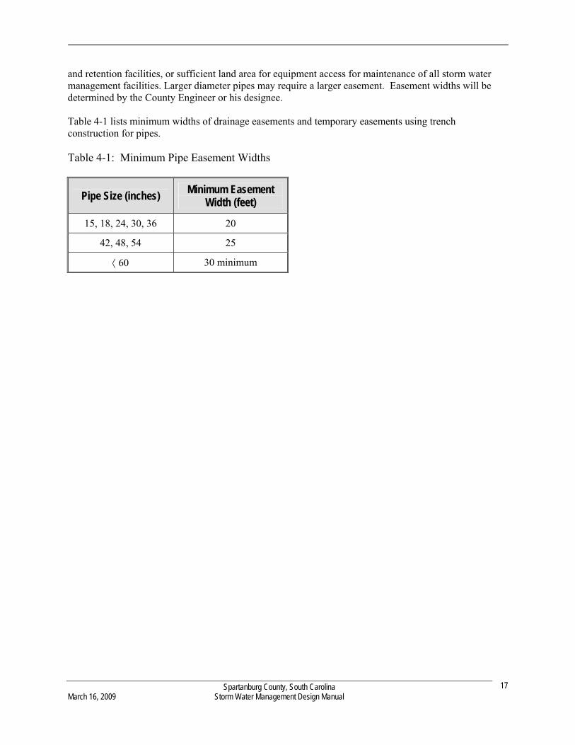
and retention facilities, or sufficient land area for equipment access for maintenance of all storm water management facilities. Larger diameter pipes may require a larger easement. Easement widths will be determined by the County Engineer or his designee. Table 4-1 lists minimum widths of drainage easements and temporary easements using trench construction for pipes. Table 4-1: Minimum Pipe Easement Widths
Pipe Size (inches) Minimum Easement
Width (feet)
15, 18, 24, 30, 36 20
42, 48, 54 25
60 30 minimum
Spartanburg County, South Carolina March 16, 2009 Storm Water Management Design Manual
17
Spartanburg County, South Carolina March 16, 2009 Storm Water Management Design Manual
18
CHAPTER 5 HYDROLOGY
5.1 Introduction
The definition of hydrology is the scientific study of water and its properties, distribution, and effects on the earth’s surface, in the soil and the atmosphere. Hydrology deals with estimating peak flow rates, volumes, and time distributions of storm water runoff. Basic hydrology is fundamental in the design of storm water management control facilities. This chapter addresses the movement of water over the land resulting directly from precipitation in the form of storm water runoff. Urbanization and land development changes a watershed’s response to precipitation. The most common effects are reduced infiltration and decreased travel time, which have the potential to significantly increase peak discharges and runoff volumes. Total runoff volume is determined by the amount of precipitation and the receiving watershed’s infiltration characteristics related to soil type, antecedent moisture conditions, cover type, impervious surfaces, and surface detention and/or retention.
The travel time, or time of concentration, of the watershed is directly related to the slope, flow path length, depth of flow, and roughness of the flow surfaces due to the type of ground cover. Peak discharge rates are based on the relationship of these parameters and on the total drainage area of the watershed, the location of the development, the effect of any flood controls or other manmade storage, and the time distribution of rainfall during a given storm event. The primary purpose of this chapter is to define the minimum computational standards and methods required to comply with the regulatory requirements of the Spartanburg County Storm Water Management Permit. Any type of computer software program that utilizes the methods described in this chapter shall be deemed as being an acceptable procedure.
5.2 Computational Standard Methods
In general, hydrologic computational methods shall be accomplished using a volume hydrograph method acceptable by Spartanburg County. The storm duration for computational purposes for these methods shall be the 24-hour rainfall event, using the National Resource Conservation Service (NRCS) Type II rainfall distribution with a 0.1 hour burst duration time increment. The rational and/or modified rational methods are acceptable for sizing individual culverts and storm drains that are not part of a pipe network or system and do not have a contributing drainage area greater than 20 acres. The storm duration for computational purposes for this method shall be equal to the time of concentration of the contributing drainage area or a minimum of 0.1 hours, whichever is less. The rational method may also be used to calculate peak flows for input into storm sewer models. When hydrograph-based versions of these models are developed which are acceptable to Spartanburg County, the hydrograph-based models will be used in lieu of the rational formula models.
5.2.1 Recommended Methodologies
The Spartanburg County recommended methods and corresponding design circumstances are listed in Table 5-1 below. If other methods are used, they must first be calibrated to local conditions and tested for accuracy and reliability and then submitted to Spartanburg County for approval. In addition, complete source documentation must be submitted for approval.
Table 5-1: Recommended methodologies based on land disturbance area
Method Size
Limitations* Comments
(Modified)Rational Method
0 – 20 Acres Acceptable for sizing individual culverts or storm drains that are not part of a pipe network or system. Not to be used for storage design.
“NRCS Method” 0 – 2000 Acres Used for estimating flow volumes from urban areas.
USGS Regression Equation
2000 acres –1,430 square
miles
See The National Flood-Frequency Program—Methods for Estimating Flood Magnitude and Frequency in Rural and Urban Areas in South Carolina, 2000 U.S. Geological Survey Fact Sheet 001-00 dated January, 2000 for more information.
*Size limitations refers to the subwatershed size to the point where storm water management facility (i.e. culvert, inlet, BMP) is located. Details of Rational Method and Modified Rational Method can be found in Chow (1988), ASCE (1996), USDA (1996, 2001), and Mays (2001). When using this methodology, regional coefficients are needed to calculate the rainfall intensity (See Table 5-2: Intensity Coefficients). NRCS Method documentation can be found on the US Department of Agriculture website (http://www.wcc.nrcs.usda.gov/hydro/hydro-tools-models-tr55.html). The USGS regression equations for South Carolina can be obtained from the US Geological Survey website (http://water.usgs.gov/osw/programs/nffpubs.html). In addition, the US Department of the Army and Air Force (1987a, 1987b) have two technical manuals addressing hydrology, “Surface Drainage Facilities for Airfields and Heliports” and “Drainage for Areas other than Airfields”.
5.3 Rainfall and Intensities
In order to determine the rainfall intensity (I) values for use with the (Modified) Rational Method, the designer should construct an intensity-duration-frequency (I-D-F) curve. The South Carolina Department of Transportation (SCDOT) has developed a formula to accurately determine the rainfall intensity values. The formula is given as:
c
c )t(b
aI
Where: I = rainfall intensity (in. / hr) tc = time of concentration (min) a, b, and c = coefficients (See Table 5-2)
Spartanburg County, South Carolina March 16, 2009 Storm Water Management Design Manual
19
For Spartanburg County, the following coefficients should be used: Table 5-2: Intensity Coefficients Intensity Coefficients
Storm Frequency (yrs.) a b c 2 237.85214 36.00878 1.03800
5 253.32925 33.54922 1.02275
10 262.87425 32.09747 1.01352
25 276.43449 30.08348 1.00054
50 285.47241 28.74568 0.99190
100 293.96606 27.46491 0.98373
Rainfall intensities for 5, 10, and 15 minute time of concentrations are given in Table 5-3. Other rainfall intensities must be calculated using the rainfall intensity equation developed by SCDOT. Table 5-3: Selected Rainfall Intensities
Selected Rainfall Intensities
Storm Frequency (yrs.) Tc = 5 min. Tc = 10 min. Tc = 15 min.
2 5.037 4.470 4.016
5 6.048 5.338 4.777
10 6.748 5.937 5.298
25 7.864 6.883 6.119
50 8.704 7.589 6.729
100 9.582 8.323 7.358
Spartanburg County, South Carolina March 16, 2009 Storm Water Management Design Manual
20
The 24-hour storm event rainfall data for various return periods to be used for projects in Spartanburg County are shown in Table 5-4. This Table reflects the current values at the time this design manual was published, check with the Engineering Division for the most recent 24-Hour Storm Event Rainfall Data. Rainfall data can also be obtained from the NOAA publication entitled Atlas 14, Volume 2 and can be found at the following website: http://hdsc.nws.noaa.gov/hdsc/pfds/index.html.
Table 5-4: 24-Hour Storm Event Rainfall Data (Rainfall values in inches)
Return Period (years)
Location 1 2 5 10 25 50 100 R Factors
NW 3.7 4.5 5.5 6.3 7.5 8.5 9.5 300
NE 3.2 3.8 4.7 5.5 6.6 7.5 8.4 275
SE 3.0 3.7 4.5 5.3 6.6 7.7 9.1 275
SW 3.1 3.7 4.6 5.4 6.7 7.8 9.2 275
Spartanburg County, South Carolina March 16, 2009 Storm Water Management Design Manual
21
Figure 5-1: County Precipitation Quadrants
Spartanburg County, South Carolina March 16, 2009 Storm Water Management Design Manual
22
CHAPTER 6 HYDRAULICS
6.1 Open Channel Hydraulics
Open channels used in major drainage systems have significant advantages related to cost, capacity, use (i.e., for recreational and aesthetic purposes) and potential for detention storage. Disadvantages include right-of-way needs and maintenance costs. Careful planning and design are needed to minimize the disadvantages and to increase the benefits. The general classifications for open channel are: (1) Natural channels, which include all watercourses that have been carved by nature through erosion; and (2) New or altered channels, which are constructed or existing channels that have been significantly altered by human effort. New or altered channels can be lined with grass, concrete, mortared rocks, or other materials. The channels should be designed for the 25-year storm with provisions for the 100-year storm within dedicated easements or right-of-way.
Channels shall be designed to carry the 25-year 24-hour design storm event.
Major channels may be designed for lower return periods if directed by Spartanburg County.
Design conditions can be assumed to be steady, uniform flow.
Minimum channel slope shall be 1.0 percent, unless supporting calculations show that there will be no pools or standing water areas formed in the channels at smaller slopes.
Except for roadside ditches, the side slopes of grassed lined channels shall be no steeper than 3H to 1V.
Manning’s Equation may be used to design open channels and swales where backwater effects created from obstructions and/or tailwater is not present.
Channels may be designed with multiple stage levels with a low flow section to carry the 2-year storm event and a high flow section to carry storms of larger frequencies.
Maximum flow velocities shall be determined based on the channel bottom material and bank slope material. Maximum channel velocities shall not exceed those velocities which cause the channel bottom material/lining to erode.
Spartanburg County allows vegetated channels. Guidance on the design of these type channels can be found in Haan et. al. (1995) or by using computer software that is capable of calculating for stability and capacity.
6.2 Hydraulics of Culverts
Culverts are conduits that are commonly used to pass drainage water through embankments. The 25-year 24-hour storm event or greater shall be used in the design of all cross-drain culverts. The 10-year 24-hour storm event or greater shall be used in the design of all interior culverts.
Spartanburg County, South Carolina March 16, 2009 Storm Water Management Design Manual
23

Culvert design shall include all cross drainage facilities that transport storm water runoff under roadways. Culvert selection techniques can range from solving empirical formulas, to using nomographs and charts, to comprehensive mathematical analysis for specific hydraulic conditions. The many hydraulic factors involved make precise evaluation time consuming and difficult without the help of computer programs and models. The actual models used for these calculations shall be at the discretion of the design professional with approval from Spartanburg County. Designs shall be based upon SCDOT requirements where applicable. The following criteria shall be followed at a minimum:
All cross-drain culverts shall be designed to pass the 25-year 24-hour design storm event without overtopping the road.
All interior culverts shall be designed to pass the 10-year 24-hour design storm event without overtopping the road.
Additional hydraulic capacity shall be required as necessary to prevent backwater effects that may adversely impact upstream property or structures.
Acceptable models for designing culverts include, but are not limited to:
- HY8 - SEDCAD4 - Pond Pack - HEC-RAS - Culvert Master
6.3 Storm Drainage Design Requirements
This section provides the design requirements for various storm water drainage system components including: Design storms, Design velocities; and, Design pipe sizes. In depth design procedures for inlet and open channel design may be referenced in the American Association of State Highway and Transportation Officials (AASHTO) Model Drainage Manual, 1991.
6.3.1 Storm Drainage Systems
Storm drainage systems shall include all storm drainage structures and pipes that do not convey runoff under public roadways. These systems are commonly referred to as lateral closed systems. 6.3.1.1 Design Storm Requirements
These storm drainage systems shall be designed based upon the following minimum criteria:
10-year 24-hour design storm event capacity for pipe design.
10-year 24-hour design storm event capacity for inlet structure design.
Spartanburg County, South Carolina March 16, 2009 Storm Water Management Design Manual
24
25-year 24-hour design storm event capacity for drainage channels. 50-year 24-hour design storm event capacity for sump inlets, unless overflow facilities are designed. 100-year 24-hour storm event shall be used to check all drainage designs related to local flooding
issues, and possible flood hazards to adjacent structures and/or property. The rational method and NRCS method for peak runoff flow rates are acceptable.
6.3.1.2 Manning’s Equation to Determine Flow Capacity
When a storm drainage system has less than 7 connections, Manning’s Equation shall be acceptable for sizing the capacity of drain pipes for non-submerged conditions where the free water surface elevation is below the crown of the pipes. 6.3.1.3 Hydraulic Grade Line
6.3.1.3.1 Requirements
All head losses in a storm drainage system shall be considered when computing the hydraulic grade line to determine water surface elevations under design conditions. Any system that contains 7 or more pipe connections shall have the hydraulic grade line computed, along with all head losses through the entire system. If the outlet is submerged in a backwater condition, a more sophisticated design methodology than Manning’s Equation shall be required. Individual head losses in the pipe systems shall be calculated. These head losses are added to a known downstream water surface elevation to give a design water surface elevation for a given flow at a desired upstream location. Various accepted computer models are available for analysis of storm drain systems under backwater and/or pipe flow surcharge conditions. See the State of Florida Department of Transportation Drainage Handbook for Storm Drains for more information on how to calculate hydraulic grade lines. 6.3.1.3.2 Pipe Size
The minimum pipe size to be used in storm drainage systems shall be 15-inches in diameter. 6.3.1.3.3 Pipe Material
Pipe material for storm drainage systems shall be reinforced concrete pipe or other material approved by the County Engineer. 6.3.1.4 Flow Velocity and Pipe Slope
The minimum design velocity for pipe flow shall be 2.0-feet/sec at the design flow or 2.5-feet/sec at full flow, whichever requires the greater slope.
The maximum design velocity shall be 20-feet/sec.
Spartanburg County, South Carolina March 16, 2009 Storm Water Management Design Manual
25
The minimum slope of storm drain systems shall be 0.5 percent. The minimum required slope shall be calculated by a modified form of Manning’s Equation.
Storm drainage systems shall be designed to convey storm water runoff by gravity flow unless
otherwise approved. 6.3.1.5 Fill Requirements
The minimum fill cover on all pipes shall be 1-foot below subgrade. The maximum cover shall be based on the design loads which are calculated from pipe shape, pipe size, pipe material and location. 6.3.1.6 Catch Basin and Inlet Design
The design methodology utilized to compute the capacity of storm drain inlets and grates shall apply the weir, orifice and pipe flow characteristics as outlined in Section 6.2. The following design requirements shall be followed: Inlets shall be designed to convey the 10-year 24-hour storm event. The maximum depth in which the water may pond above or around an inlet must not threaten
surrounding permanent structures or public facilities including vehicular or pedestrian traffic. Inlets placed in sump conditions shall have emergency overflow points designed. Inlets placed in roadway gutter lines must be spaced to prevent flow from entering public road
intersections.
Maximum spread of 6-feet in the travel lane. Valley gutter shall have a maximum allowable spread of 7-feet.
Standard 1-foot 6-inch curb and gutter is allowed a total maximum spread of 8-feet from the face
of the curb.
Spartanburg County, South Carolina March 16, 2009 Storm Water Management Design Manual
26
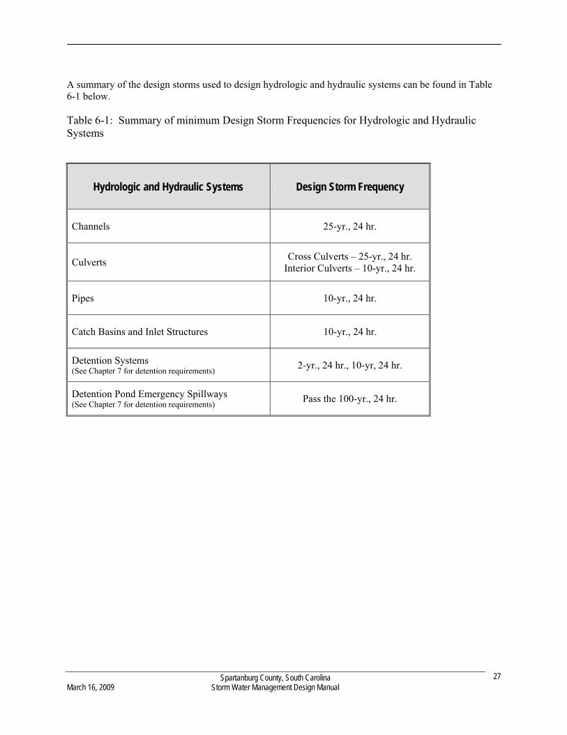
A summary of the design storms used to design hydrologic and hydraulic systems can be found in Table 6-1 below. Table 6-1: Summary of minimum Design Storm Frequencies for Hydrologic and Hydraulic Systems
Hydrologic and Hydraulic Systems Design Storm Frequency
Channels 25-yr., 24 hr.
Culverts Cross Culverts – 25-yr., 24 hr.
Interior Culverts – 10-yr., 24 hr.
Pipes 10-yr., 24 hr.
Catch Basins and Inlet Structures 10-yr., 24 hr.
Detention Systems (See Chapter 7 for detention requirements) 2-yr., 24 hr., 10-yr, 24 hr.
Detention Pond Emergency Spillways (See Chapter 7 for detention requirements)
Pass the 100-yr., 24 hr.
Spartanburg County, South Carolina March 16, 2009 Storm Water Management Design Manual
27

Spartanburg County, South Carolina March 16, 2009 Storm Water Management Design Manual
28
CHAPTER 7 STORM WATER DETENTION DESIGN AND DOWNSTREAM ANALYSIS
This chapter provides policies and technical procedures for analyzing storm water facilities required for land disturbance activities in Spartanburg County. The design methods and criteria outlined in this chapter shall be used in the design and evaluation of detention systems utilized for storm water quantity control.
7.1 Hydrologic and Hydraulic Design Criteria
All designs of detention systems utilized for storm water quantity control shall be submitted with a design summary report when applying for a Storm Water Management Permit. The following design criteria shall be implemented for water quantity control unless a waiver is granted on a case-by-case basis. Provide extended detention of the first one (1) inch of runoff over the entire site and release it over a
period of 24 to 72 hours to reduce flows and protect downstream channels from erosive velocities and unstable conditions.
Post-development discharge rates from the entire development area shall not exceed pre-development
discharge rates for the 2-, and 10-year frequency 24-hour duration storm events.
The same hydrologic procedures shall be used in determining both the pre-development and post-development peak flow rates.
Post-development discharge velocities in receiving channels shall be non-erosive flow velocities and
shall be equal to or less than the pre-development 2-year 24-hour storm event flow velocities. Emergency spillways shall be designed to safely pass the post-development 100-year 24-hour storm
event. A minimum 6 inch freeboard shall be maintained in detention basins. (See Section 7.2.1 Freeboard) All dry detention basin volumes shall be drained from the structures within 72 hours. Side slopes shall not be steeper than 3:1 and shall not be flatter than 6:1. (3:1 ≤ slope ≤ 6:1) Dam top widths will be a minimum of 10 feet wide. A project may be eligible for a waiver from the storm water management requirements for water
quantity control if the applicant can justly verify that:
The proposed project will not create any significant adverse effects on the receiving natural waterway downstream of the property.
Controlling the peak flow rate as a means for storm water management would create, aggravate,
or accelerate downstream flooding.
Detention systems on residential property with shared County maintenance shall have additional requirements that must be met:
Pond access drives are required to be installed for County use with 20 foot wide access easements and
12 foot wide driveways to provide access to the pond.
Access drives must not exceed a 4:1 slope ratio. A 6 foot tall chain-linked fence must be installed around the detention pond crossing over the center
of the top of dam. Fences shall not be installed on slopes.
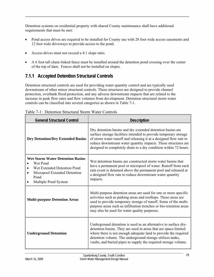
7.1.1 Accepted Detention Structural Controls
Detention structural controls are used for providing water quantity control and are typically used downstream of other minor structural controls. These structures are designed to provide channel protection, overbank flood protection, and any adverse downstream impacts that are related to the increase in peak flow rates and flow volumes from development. Detention structural storm water controls can be classified into several categories as shown in Table 7-1.
Table 7-1: Detention Structural Storm Water Controls
General Structural Control Description
Dry Detention/Dry Extended Basins
Dry detention basins and dry extended detention basins are surface storage facilities intended to provide temporary storage of storm water runoff and releasing it at a designed flow rate to reduce downstream water quantity impacts. These structures are designed to completely drain to a dry condition within 72 hours.
Wet Storm Water Detention Basins Wet Pond Wet Extended Detention Pond Micropool Extended Detention
Pond Multiple Pond System
Wet detention basins are constructed storm water basins that have a permanent pool or micropool of water. Runoff from each rain event is detained above the permanent pool and released at a designed flow rate to reduce downstream water quantity impacts.
Multi-purpose Detention Areas
Multi-purpose detention areas are used for one or more specific activities such as parking areas and rooftops. These areas are used to provide temporary storage of runoff. Some of the multi-purpose areas such as infiltration trenches or bio-retention areas may also be used for water quality purposes.
Underground Detention
Underground detention is used as an alternative to surface dry-detention basins. They are used in areas that are space-limited where there is not enough adequate land to provide the required detention volume. The underground storage utilizes tanks, vaults, and buried pipes to supply the required storage volume.
Spartanburg County, South Carolina March 16, 2009 Storm Water Management Design Manual
29
7.2 Design Procedures
This section provides the general design procedures for the design of storm water quantity structures. The following items shall be required for the design of these structures, and routing flows through them: Compute the inflow hydrograph for the structure. Compute a stage-storage relationship for the proposed structure. A stage-storage curve defines the relationship between the depth of water and storage volume within the detention facility. Compute stage-discharge relationship of the outlet control structures. Perform routing calculations for the 2, 10 and 100-year 24-hour storm events. These may be done by
hand, or may be done by using a storage routing computer model. Evaluate the control structure outlet flow velocity and provide velocity control or channel
stabilization if needed. Routing of hydrographs is critical to the proper design of storm water quantity control structures. Storage design procedures have been formulated without using routing, but the use of these methods in designing storm water quantity structures has not produced acceptable results for the Southeastern United States. Hand calculations are available for routing hydrographs through detention structures, however they are time consuming and inefficient when multiple designs are required to be evaluated. For this chapter, it is assumed that the design professional will be using one of the many computer software packages available to perform storage routing calculations. Input parameters typically required for computer software packages include: Hydrological parameters of the development site
Area Curve Numbers Time of concentration
Hydraulic parameters of detention structures Stage-storage relationship Stage-discharge relationship
7.2.1 Freeboard
A minimum freeboard of 6-inches between the high water elevation (10-year, 24-hour design storm) and the bottom of the emergency spillway shall be provided for impoundment depths less than 15-feet.
A minimum freeboard of 6-inches (from top of dam) above the 100-year 24-hour design storm high
water elevation shall be provided for impoundment depth less than 15-feet. Impoundment depths greater than 15-feet are subject to the requirements of the Safe Dams Act unless
the facility is excavated.
Spartanburg County, South Carolina March 16, 2009 Storm Water Management Design Manual
30

7.3 Downstream Analysis
Downstream analysis shall be required for all development sites unless a waiver or variance is granted from this analysis. When water quantity controls are implemented, an off-site analysis waiver may not be required, provided that all required design criteria of the design manual are met. In some cases the design professional may verify that storm water quantity controls may adversely impact downstream conditions. Therefore, downstream analysis shall be performed prior to sizing storm water quantity control structures to determine the extent of the controls to be implemented. Downstream analysis may show that more stringent controls need to be implemented to effectively prevent any adverse downstream impacts.
7.3.1 Downstream Analysis Limits
Hydrologic and hydraulic engineering analysis shall be implemented to determine the downstream effects from any development activity. This analysis shall extend downstream to a specific point of concern. The point of concern may be identified by the Storm Water Manager or his designee in certain situations. The following are typical points of concern:
The point where the development represents less than 10 percent of the total drainage of the
watershed to that point. The first downstream road crossing. Downstream residential lots. Location of known existing flooding, drainage, or erosion problems. The primary areas of analysis shall be done for:
The development area, All drainage exit points from the property, The receiving channel at the exit points, and Each component of the downstream system including:
Channels Pipes Culverts Bridges Overbank areas Overbank structures.
7.3.2 Downstream Analysis Design Storm Events
All downstream analysis studies shall be done using the 2-, 10-, 25-, and 100-year 24-hour storm events.
Spartanburg County, South Carolina March 16, 2009 Storm Water Management Design Manual
31
7.3.3 Downstream Analysis Criteria
The downstream analysis shall determine whether the design storm events of interest cause or increase flooding, drainage, or erosion impacts to downstream properties or road crossings. The analysis criteria shall include, but is not limited to:
Existing land use curve numbers shall be used for developed areas upstream.
Reasonable assumptions for future development shall be made for curve numbers for undeveloped properties upstream of the construction site. The Engineering Division can aid in the determination of future watershed development conditions as well as appropriate curve numbers to use in the analysis.
Existing land use for downstream areas of interest may be used, but future land use, when applicable,
is recommended for conservative results. Routing of flows using an accepted hydrologic and hydraulic method from Chapters 5 and 6. Hydraulic step-backwater calculations (Corps of Engineer’s HEC-2 or HEC-RAS models or
equivalent) shall be performed to determine flood elevations of any downstream impacted areas. The effects of any upstream and proposed storm water quantity or quality structures.
7.3.4 Improvement Options
If the downstream analysis determines that the development of a particular site does contribute to flooding, drainage, or erosion problems, then at least one the following improvements shall be implemented:
On-site water quantity control Off-site water quantity control Improvements to the downstream storm water conveyance system
7.4 Establishment of Limited Construction Areas
The applicant may determine appropriate Limited Construction Areas where local knowledge, soil type, historic water marks, vegetation, hydrologic or hydraulic study indicates potential hazards. Limited Construction Areas shall be determined and provided for: Subdivision proposals and other proposed developments that have more than 5 lots or are greater than
five acres and have an upstream drainage basin of one-half square mile or greater. Development projects where a known problem exists upstream or downstream of the development
location.
Spartanburg County, South Carolina March 16, 2009 Storm Water Management Design Manual
32

Applicants that elect not to determine and mark Limited Construction Areas shall state on the final plat: “This project has not been studied by FEMA for flood risk nor has this project been studied by the preparer of this plat to determine whether or not it is subject to flooding.”
Spartanburg County, South Carolina March 16, 2009 Storm Water Management Design Manual
33
Spartanburg County, South Carolina March 16, 2009 Storm Water Management Design Manual
34
CHAPTER 8 EROSION AND SEDIMENT CONTROL
8.1 Introduction
Natural erosion has been occurring since the earth was formed. This process, which generally occurs at a relatively slow rate, has shaped and molded the earth’s surface in the form we recognize today. Man-made erosion, on the other hand, occurs at a quicker rate. Man-made erosion caused by inappropriate management of storm water runoff from development sites contributes greatly to urban land breakdown and water pollution. It is estimated that erosion on unprotected construction sites may average up to 30 tons per acre per year. Construction-generated storm water runoff often contains sediment, toxic chemicals, oil and grease, pesticides (herbicides, insecticides, or rodenticides), trace metals, and other contaminants which serve as a significant source of water pollution and threatens public health, fish and other wildlife. Nutrients from fertilizers containing nitrogen, phosphorus, and potassium are carried by eroded sediment. These nutrients fuel weed and algae growth, and make outdoor water areas unattractive for swimming and other recreational activities. The resulting water and environmental damage caused by construction-related erosion is often extensive, long-term, costly and time-consuming to correct.
8.2 Erosion Protection and Sediment Control Requirements
The Spartanburg Storm Water Ordinance requires that an Erosion Prevention and Sediment Control (EPSC) plan be developed and approved, prior to initiating construction on land disturbing activities that are in excess of 5,000 square feet or require a building permit or as directed by a General Permit.
8.2.1 EPSC Development Standards
Water quality control is also an integral component of storm water management. The following design criteria are established for water quality protection unless a waiver or variance is granted on a case-by-case basis. The storm water management regulations require that when storm water runoff drains to a single outlet from land disturbing activities which disturb ten (10) acre or more then a sediment basin must be designed to meet a removal efficiency of 80 percent for suspended solids or 0.5 ML/L peak settleable solids concentration, which ever is less. The efficiency shall be calculated for disturbed conditions for the 10-year 24-hour design event. The outfall device or system design shall take into account the total drainage area flowing through the disturbed area to be served by the basin. Additional water quality design criteria can be found in section 9.2 Water Quality Design Criteria of this manual.
8.2.2 Alternative Erosion Prevention and Sediment Control BMPs
To encourage the development and testing of innovative alternative EPSC BMPs, alternative management practices that are not included in the design manual, Standard Specifications and Standard Drawings may be allowed upon review and approval. To use an alternative BMP, the design professional shall submit substantial evidence that the proposed measure will perform at least equivalent to currently approved BMPs contained in the design manual, Standard Specifications and Standard Drawings.
Evidence may include, but is not limited to: Supporting hydraulic and trapping efficiency calculations. Peer-review by a panel of licensed professional engineers. Research results as reported in professional journals. Manufacturer literature. To justify the efficiency of innovated EPSC BMPs, the owner may be required to monitor the trapping efficiency of the structure. If satisfactory results showing that trapping efficiencies of greater than 80 percent are obtained, the innovative BMP may be used and no other monitoring studies shall be required. If monitoring shows that a certain BMP is not sufficient or if Spartanburg County finds that a BMP fails or is inadequate to contain sediment, other upstream and downstream BMPs shall be implemented to reach the required efficiency. For a comprehensive list of Erosion Prevention Measures and Temporary Sediment Control Measures refer to SCDHEC website for a comprehensive BMP Manual.
8.3 Runoff Control and Conveyance Measures
In addition to temporary measures, EPSC BMPs that control runoff should in addition to other BMPs listed in the South Carolina Stormwater Management and Sediment Control Handbook For Land Disturbance Activities (rev. 02/97) provide the overall protection of downstream environments. Suggested varieties include pipe slope drains, protection at stream crossings, de-watering, level spreaders, subsurface drains, diversion dikes, and berms.
8.4 Report Development
Specific requirements for the erosion and sediment control section of the Stormwater Management Permit Application shall include, but is not limited to the following items: The plans shall contain a description and location of the predominant soil types on the site. The plans shall show the location and delineation of vegetative covers that are not to be disturbed. The plans shall contain the location and dimensions of all storm water drainage and natural drainage
systems on, and adjacent to the development site. The plans shall contain both existing and planned site topography. The plans shall contain the location and dimensions of all land disturbing activities. If applicable, the plans shall contain the potential location for soil stock-piles and the related
stabilization structures or techniques for these stock piles. The plans shall include details, dimensions and descriptions of all temporary and permanent erosion and sediment control measures. The inspection schedule shall be developed prior to the start of construction. SCDHEC provides two inspection approaches listed below:
Spartanburg County, South Carolina March 16, 2009 Storm Water Management Design Manual
35
- Notes contained in the erosion and sediment control plan shall state that all sediment and erosion
control devices shall be inspected every seven (7) days. If site inspections identify BMPs that are damaged or are not operating effectively, maintenance must be performed as soon as practical or as reasonably possible and before the next storm event whenever practicable.
- Notes contained in the erosion and sediment control plan shall state that all sediment and erosion
control devices shall be inspected at least once every fourteen (14) calendar days and within 24 hours of the end of a storm event of 0.5 inches or greater.
Notes contained in the erosion and sediment control plan shall state that when construction or land disturbance activities have temporarily ceased on any portion of a site, temporary site stabilization measures shall be required as soon as practicable, but no later than 14 calendar days after the activity has ceased. Notes contained in the erosion and sediment control plan shall state that final stabilization of the site shall be required within 14 calendar days of the completion of construction. Specifications for a sequence of construction operations shall be contained on all plans describing the relationship between the implementation and maintenance of sediment controls including permanent and temporary stabilization and the various phases of earth disturbance and construction. The specifications for the sequence of construction shall contain, at a minimum, the following:
Preconstruction conference Clearing and grubbing for those areas necessary for installation of perimeter controls Installation of sediment basins and traps Construction of perimeter controls Remaining clearing and grubbing Road grading Grading for the remainder of the site Utility installation and whether storm drains will be used or blocked until the completion of
construction Final grading, landscaping, or stabilization Removal of sediment control structures
Design computation for all erosion and sediment control structures.
List of the trapping efficiency of each sediment control structure. Calculation of required sediment storage volumes. Explanation of any computer models or software used with highlights of the output data. Description of required clean-out frequencies and maintenance schedules.
Spartanburg County, South Carolina March 16, 2009 Storm Water Management Design Manual
36
Spartanburg County, South Carolina March 16, 2009 Storm Water Management Design Manual
37
CHAPTER 9 WATER QUALITY
9.1 Anti-degradation Rules for Impaired Waters
This section of the design manual provides information to ensure that Anti-degradation Rules are implemented for activities that contribute nonpoint source pollution to adjacent impaired waterbodies. The Anti-degradation Rules are specifically formulated to ensure that no new activities will further degrade 303(d) listed waterbodies that are not presently meeting water quality standards. The involvement in the Anti-degradation Rules shall occur through the Spartanburg County Storm Water Permitting, Section 401 Water Quality Certification, Critical Area Planning, and State Navigable Water Permitting. Spartanburg County shall implement the Anti-degradation Rules when issuing NPDES permits for point source and nonpoint source loadings into impaired waters. The activities of primary concern are land development projects that are immediately adjacent to and discharge runoff of storm water into impaired waters.
9.1.1 Impaired Waterbodies
Every two years, the South Carolina Department of Health and Environmental Control (DHEC) is required by Section 303(d) of the Clean Water Act to identify waterbodies that are not meeting water quality standards despite the implementation of technology based controls. The listing of the impaired waters lists each waterbody by name, monitoring station number, hydrologic unit, and basin. The category of impairment and pollutant(s) of concern shall also be identified for each waterbody.
9.1.2 Applicability
For sites that discharge to a receiving water on the 303(d) List of Impaired Waters, the applicant must ensure that their storm water pollution prevention plan (SWPPP) does not allow storm water discharge(s) that will contribute to violations of the water quality standards. To accomplish this, the applicant must determine whether or not their discharge(s) may contain any pollutant that has caused the impairment. If their storm water discharge(s) will not contain the pollutant(s) of concern, no additional requirements are necessary. If their discharge(s) will contain the pollutant(s) of concern, then the applicant must carefully evaluate the selected BMPs and their performance to ensure that storm water discharge(s) will not contribute to or cause a violation of water quality standards. For projects that disturb twenty-five (25) acres or more, the SWPPP must contain a written quantitative and qualitative assessment that the BMPs selected will control the storm water discharge(s) so that they will not contribute to or cause a violation of water quality standards. The concern for water quality discharging to impaired waters pertains to runoff during construction and runoff after the project is finished and stabilized.
9.1.3 Water Quality Impairment
Design professionals shall determine whether runoff from the proposed land disturbance contains pollutants that are already causing impairment of the adjacent waterbody. These pollutant discharges will vary from site to site. If storm water runoff from the proposed land development will contribute pollutants that already cause water quality impairment, the design professional must provide assurance that measures and controls will be implemented to prevent further problems to the impairment.
The techniques and controls discussed in this chapter shall be utilized to provide the removal of any harmful pollutants. There is not a specific methodology that must be followed in determining the BMPs selected and utilized to follow the Anti-degradation Rules. However, the calculations and descriptions
must show that the water quality BMPs to be installed will ensure that runoff from the site will not cause or contribute to further degradation of the impaired waterbody. For pollutants causing impairment for which a numeric water quality standard has been adopted (i.e. fecal coliform, pH, metals), calculations shall be performed and submitted showing that the pollutants in the runoff from the development site will not exceed the applicable in-stream water quality standards. The runoff discharged through the last water quality BMP shall have a water quality level equal to or better than the in-stream standard.
The design professional shall provide assurance in a different manner when the water quality impairment is not a pollutant itself, but is affected by a pollutant that can be regulated such as dissolved oxygen levels are affected by biochemical demand. In these situations, a reasonable approach to show that runoff will not further degrade the adjacent impaired waterbody is to show that the post-development loading of a particular pollutant is less than or equal to pre-development loading. This ensures that there will be no net increase of loading of that particular pollutant and no further lowering of the water quality standard. In most cases, the effectiveness of the designed water quality BMPs will not require water quality sampling. However, for certain situations, monitoring data to confirm the effectiveness of the BMPs may be required from the applicant or landowner.
9.1.4 Total Maximum Daily Loads (TMDLs)
A TMDL is the total amount of pollutant a waterbody can receive from all sources and still meet the required water quality standard. For some waterbodies, a TMDL will be developed that includes recommended limits or loads for both point sources and nonpoint sources. For other waterbodies, the identified load may be only for nonpoint sources, or for point sources only.
9.2 Water Quality Design Criteria
Water quality control consists of post-development controls to help reduce the impacts of development on the water quality of the receiving downstream waterbodies. The following design criteria are established for water quality control unless a waiver is granted on a case-by-case basis. Permanent water quality ponds and detention structures having a permanent pool elevation shall be
designed to store and release the first ½-inch of runoff from the site over a minimum period of 24-hours. The water quality storage volume of these water quality structures shall be designed to accommodate at least ½-inch of runoff from the entire site.
Permanent water quality structures not having a permanent pool elevation shall be designed to store
and release the first 1-inch of runoff from the site over a minimum period of 24-hours. Permanent water quality infiltration practices shall be designed to accommodate at a minimum the
first 1-inch of runoff from impervious areas located on the site. When existing wetlands are intended to be water quality structures, the Stormwater Management
Permit shall not be implemented until all necessary Federal and State permits have been obtained. Commercially available products can be used as water quality control measures. Applicability of
such devices will be determined on a project-by-project basis.
Spartanburg County, South Carolina March 16, 2009 Storm Water Management Design Manual
38
9.3 Water Quality BMPs
The varieties of water quality BMPs are numerous. With proper planning, installation, and maintenance, BMPs can be expected to reduce pollutant loads to receiving waters, reduce erosion, provide health and safety benefits, and be cost effective. BMPs are considered either structural or non-structural. Structural water quality control structures are recommended for use with a wide variety of land uses and development types. These controls have demonstrated the ability to effectively treat runoff volume to reduce the amounts of pollutants discharged to the downstream system. Structural storm water quality controls are classified into the following categories: General Application Controls, Detention Structural Controls, and Limited Application Controls. General application structural controls are recommended for use in a wide variety of application situations. These structural controls have demonstrated the ability to effectively treat water quality volumes and are presumed to be capable of removing 80 percent of the total suspended solids (TSS) load typically found in urban post-development runoff. Detention structural controls are used for providing water quantity control and are typically used downstream of other minor structural controls. These structures are designed to provide channel protection, overbank flood protection, and any adverse downstream impacts that are related to the increase in peak flow rates and flow volumes from development. For a comprehensive description of potential structural controls, please refer to SCDHEC BMP manual on their website. Limited application structural controls are those that are recommended only for limited use for special site or design conditions. Generally, these practices can not alone achieve 80 percent TSS removal goal and are intended for hotspots for specific land use constraints or conditions. Limited application controls may be used within a system of water quality controls and are very effective pre-treatment structures for the General Application Controls. Limited application structural controls should be designed and used only in development situations where regular maintenance is guaranteed. The limited storm water controls can be classified into several categories as shown in Table 9-1.
Spartanburg County, South Carolina March 16, 2009 Storm Water Management Design Manual
39
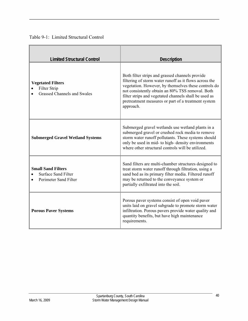
Table 9-1: Limited Structural Control
Limited Structural Control Description
Vegetated Filters Filter Strip Grassed Channels and Swales
Both filter strips and grassed channels provide filtering of storm water runoff as it flows across the vegetation. However, by themselves these controls do not consistently obtain an 80% TSS removal. Both filter strips and vegetated channels shall be used as pretreatment measures or part of a treatment system approach.
Submerged Gravel Wetland Systems
Submerged gravel wetlands use wetland plants in a submerged gravel or crushed rock media to remove storm water runoff pollutants. These systems should only be used in mid- to high- density environments where other structural controls will be utilized.
Small Sand Filters Surface Sand Filter Perimeter Sand Filter
Sand filters are multi-chamber structures designed to treat storm water runoff through filtration, using a sand bed as its primary filter media. Filtered runoff may be returned to the conveyance system or partially exfiltrated into the soil.
Porous Paver Systems
Porous paver systems consist of open void paver units laid on gravel subgrade to promote storm water infiltration. Porous pavers provide water quality and quantity benefits, but have high maintenance requirements.
Spartanburg County, South Carolina March 16, 2009 Storm Water Management Design Manual
40
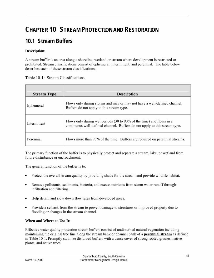
Spartanburg County, South Carolina March 16, 2009 Storm Water Management Design Manual
41
CHAPTER 10 STREAM PROTECTION AND RESTORATION
10.1 Stream Buffers
Description: A stream buffer is an area along a shoreline, wetland or stream where development is restricted or prohibited. Stream classifications consist of ephemeral, intermittent, and perennial. The table below describes each of these stream classifications: Table 10-1: Stream Classifications:
Stream Type Description
Ephemeral
Flows only during storms and may or may not have a well-defined channel. Buffers do not apply to this stream type.
Intermittent
Flows only during wet periods (30 to 90% of the time) and flows in a continuous well-defined channel. Buffers do not apply to this stream type.
Perennial Flows more than 90% of the time. Buffers are required on perennial streams.
The primary function of the buffer is to physically protect and separate a stream, lake, or wetland from future disturbance or encroachment. The general function of the buffer is to: Protect the overall stream quality by providing shade for the stream and provide wildlife habitat. Remove pollutants, sediments, bacteria, and excess nutrients from storm water runoff through
infiltration and filtering. Help detain and slow down flow rates from developed areas. Provide a setback from the stream to prevent damage to structures or improved property due to
flooding or changes in the stream channel. When and Where to Use It: Effective water quality protection stream buffers consist of undisturbed natural vegetation including maintaining the original tree line along the stream bank or channel bank of a perennial stream as defined in Table 10-1. Promptly stabilize disturbed buffers with a dense cover of strong rooted grasses, native plants, and native trees.
Stream Buffer Requirement: 35 feet average width, 20 feet minimum width. Add 10 feet to the average and minimum width where slopes exceed ten percent or greater. Stabilization and protection of the buffer is critical to water quality. Clearing and cutting of vegetation is prohibited with the desirable vegetation being mature forest. Minimal maintenance is allowed for creek flow and potential danger to life or property. Use of the buffer includes flood control structures, stream bank stabilization and restoration, boardwalks to the water, boat launches, docks, footpaths parallel to the water, storm water channels, public or private water intakes, public or private wastewater outlets, and utility or road crossings. The Engineering Division has the latitude to allow sanitary sewer inside the buffer. Sanitary sewer shall be encouraged for water quality. Stream buffers shall be marked on the final plat. All buffer widths are measured from the top of the bank. Streams without a defined top of bank shall be measured from the typical high water mark or the point vegetation has been wrested by normal flow or wave action. Waivers: Property with vested rights and single family residential lots not part of a larger common development are exempt. Agriculture and forestry activities are exempt. Man-made lakes and ponds are exempt but buffers are highly encouraged in these locations. Work performed under Federal and State permits are exempt after County Engineering Division review and comment. Buffers may be reduced or eliminated due to site specific conditions. Alternative water quality best management practices designed by qualified professionals may be used in lieu of stream buffers. The County Engineer may waive buffer requirements where appropriate. Buffer Maintenance: Buffer boundaries shall be defined and clearly marked during, and after construction is complete. The removal of invasive species is encouraged. Property Owners or Property Owner Associations shall maintain buffer zones that fall within the boundaries of their property. Additional Information: Additional information can be found in the most recent version of the South Carolina DHEC Stormwater Management BMP Handbook.
10.2 Streambank Stabilization
Bioengineering systems are installed to establish vegetation on bank slopes, provide soil protection, control erosion and reinforce the outer layers of the bank slope. In general terms, eroded streambank slopes are re-shaped to a workable shape and live-cuttings of woody native plants are installed into the slope during the dormant season. The cuttings develop root systems and flourish to provide a dense vegetation growth. Structural streambank stabilization is used where vegetative stabilization practices are not practical and where the streambanks are subject to heavy erosion from increased flows or disturbance during
Spartanburg County, South Carolina March 16, 2009 Storm Water Management Design Manual
42
construction. Stabilization should occur before any land development in the watershed area. Stabilization can also be retrofitted when erosion of a streambank occurs. All applicable Federal Army Corps of Engineers and State DHEC Regulations, including Section 404 of the Clean Water Act that regulates the placement of fill-in wetlands, must be met while working in the stream. Streambank stabilization structures should be inspected regularly and after each large storm event. Structures should be maintained as installed. Structural damage should be repaired as soon as possible to prevent further damage or erosion to the streambank. Additional information can be found in the most recent version of the South Carolina DHEC Stormwater Management BMP Handbook.
Spartanburg County, South Carolina March 16, 2009 Storm Water Management Design Manual
43
Spartanburg County, South Carolina March 16, 2009 Storm Water Management Design Manual
44
CHAPTER 11 REFERENCES ASCE, (1996). Hydrology Handbook. ASCE Manuals and Reports of Engineering Practice No. 28. ASCE & WEF, (1994). Design and Construction of Urban Stormwater Management Systems. ASCE Manuals and Reports of Engineering Practice No. 77, WEF Manual of Practice No. FD-20. American Association of State Highway and Transportation Officials, (1999). “Model Drainage Manual.” Atlanta Regional Commission, (2001) “Georgia Stormwater Management Manual- Volume 1: Stormwater Policy Guidebook, 1st Edition. Atlanta Regional Commission, (2001) “Georgia Stormwater Management Manual- Volume 2: Technical Handbook, 1st Edition. Chow, V.T., Maidment, D., and Mays L., (1988). Applied Hydrology. McGraw-Hill, NY. Haan, C. T., Barfield, B. J., and Hayes, J. C., (1995). Design Hydrology and Sedimentology for Small Catchments. Academic Press, San Diego, Ca. FEMA, (1998). Federal Guidelines for Dam Safety. Interagency Committee on Dam Safety, http://www.fema.gov/fima/damsafe/eap_toc.shtm. Mays, L., (2001). “Hydrology for Drainage System Design and Analysis,” in L. W. Mays, ed., Stormwater Collection Systems Design Handbook. McGraw-Hill, NY, p. 1-1 – 1-53. Paine, J., and Akan, A., (2001). “Design of Detention Systems,” in L. W. Mays, ed., Stormwater Collection Systems Design Handbook. McGraw-Hill, NY, p. 7-1 – 7-66. Prince George’s County, (1999a). “Low-Impact Development Design Strategies - An Integrated Design Approach.” Department of Environmental Resources, Programs and Planning Division, Prince George’s County, Maryland. Prince George’s County, (1999b). “Low-Impact Development Hydraulic Analysis.” Department of Environmental Resources, Programs and Planning Division, Prince George’s County, Maryland. Richland County, (2001). “Section 4 – Storm Drainage Design Standards.” Richland County Land Development Requirements, Richland County, South Carolina. South Carolina Department of Health and Environmental Control, (2002). “Stormwater Management and Sediment Control Handbook for Land Disturbance Activities.” Prepared by the Bureau of Water and OCRM. Schueler, T. R. (1987). “Controlling Urban Runoff: A Practical Manual for Planning and Designing Urban BMPs,” Metropolitan Washington Council of Governments. Shwab, Glenn O. and Richard K. Frevert, (1985). Elementary Soil and Water Engineering. John Wiley & Sons, New York, New York.
United States Department of Agriculture, (1986). “Urban Hydrology for Small Watersheds.” Technical Release No. 55, 2nd Edition, Natural Resources Conservation Service, Conservation Engineering Division, Washington D.C. United States Department of the Army and the Air Force, (1991). “Drainage and Erosion Control Structures for Airfields and Heliports”. US Army Technical Manual # 5-280-3/ US Air Force Manual # 88-5, Chap. 3. United States Department of the Army and the Air Force, (1987a). “Surface Drainage Facilities for Airfields and Heliports”. US Army Technical Manual # 5-820-1/ US Air Force Manual # 88-5, Chap. 1. United States Department of the Army and the Air Force, (1987b). “Drainage for Areas Other Than Airfields”. US Army Technical Manual #5-8204/ US Air Force Manual # 88-5, Chap 4. United States Department of the Army, Army Corps of Engineers, (1999). “Design Policy for Military Construction.” Engineering Regulation # 1110-345-100. United States Department of the Army, Army Corps of Engineers, (1999). “Engineering and Design for Civil Works Projects.” Engineering Regulation # 1110-2-1150. United States Department of Transportation, (1996). “Highway Hydrology – Hydraulic Design Series # 2.” Federal Highway Administration, Publication # FHWA-SA-96-067. September 2007 United States Department of Transportation, (2001). “Introduction to Highway Hydrology – Hydraulic Design Series # 4.” Federal Highway Administration, Publication # FHWA NHI 01-019. United States Department of Transportation, (2001a). “Hydraulic Design of Highway Culverts – Hydraulic Design Series # 5.” Federal Highway Administration, Publication # FHWA-NHI-01-020. United States Department of Transportation, (2001b). “Urban Drainage Design Manual – Hydraulic Engineering Circular # 22.” Federal Highway Administration, Publication # FHWA-NHI-01-021. Urban Drainage and Flood Control District, (2003). Urban Storm Drainage Criteria Manual, Volume III. Denver, CO. WEF & ASCE, (1998). Urban Runoff Quality Management, WEF Manual of Practice No. 23, ASCE Manual and Report on Engineering Practice No. 87. Yen, B., (2001). “Hydraulics of Sewer Systems,” in L. W. Mays, ed., Stormwater Collection Systems Design Handbook. McGraw-Hill, NY, p. 6-1 – 6-113.
Spartanburg County, South Carolina March 16, 2009 Storm Water Management Design Manual
45