Embed Size (px)
Citation preview
Greene County Soil & Water Conservation District 907 County Office Building, Cairo NY 12413
Phone (518) 622-3620 Fax (518) 622-0344
June 5, 2017
Jeffrey McCullough - Stormwater Compliance Section
NYSDEC Division of Water Region 4
Office of Environmental Quality
1130 North Westcott Road
Schenectady, NY 12306
Re: Batavia Kill Restoration at Kastanis Project- Request for Written Approval from the
NYSDEC to Disturb More Than Five Acres of Soil at Any One Time
Dear Mr. McCullough,
The purpose of this letter is to provide requested information to NYSDEC Region 4 Division of Water
staff to review a request to disturb more than five acres of soil at any one time. As stated in Part II.C.3
of the NYSDEC State Pollutant Discharge Elimination System (SPDES) General Permit for Storm
Water Discharges from Construction Activity (GP 0 15 002): “The owner/operator of a construction
activity shall not disturb greater than five (5) acres of soil at any one time without prior written
authorization from the Department.”
The reasoning for requesting approval to disturb areas greater than five acres is the project site location
within the immediate stream corridor (Batavia Kill) and risk of water quality contravention to New York
City Water Supply and aquatic habitat. Overall construction timing and duration, dewatering operation
requirements and limitations, site soils, cut and fills were considered in the development of the attached
Stormwater Pollution Prevention Plan (SWPPP) and Erosion and Sediment Control Plan (ESC Plan).
This project requires dewatering of the stream channel to perform mass grading operations within the
immediate stream corridor. The project drainage area to the site is 53.8 square miles requiring an
estimated dewatering capacity of 50 cubic feet per second to be constructed during the base flow period
(July and August). Both passive and pump around scenarios for surface water dewatering were weighed
against site constraints including soils, site topography and channel slope, inflow rates, and risk for
water quality contravention. A pump around system was selected that divided the project area into four
phases with work progressing downstream in approximately 900 foot lengths. Each phase will include a
clean water pump system for the diversion for groundwater and a turbid water pump system. The
turbidity pump will be placed at the downstream extent of each phase to collect turbid water and divert it
to adjacent agricultural fields for settling and infiltration. As part of Contractor requirements, a primary
backup pump with a common capacity is required to be on standby. This same scenario has been was
2
proven effective and used in constructing several stream restoration projects in this watershed with
similar and larger drainage areas.
In general the requested allowance will reduce overall construction duration and reduce the overall risk
of inundation of work areas by the Batavia Kill. Smaller disturbances will require additional pump
setups, increasing construction duration and risk of water quality impact.
To support this request, a comprehensive phasing plan/construction sequence schedule was developed
for the project. This is described in the attached SWPPP and ESC Plan drawings that identifies the time
the acreage to be disturbed for all segments within all phases and timeframes over which the activities
are expected to occur (start and end dates). The size of disturbance was limited by stabilizing one
segment prior to the commencement of construction on the next segment.
Further more aggressive measures to adequately control erosion and sedimentation shall be implemented
to reduce the potential for environmental impact. For rapid soil stabilization onsite, an adequate supply
of straw mulch and mulching equipment will remain be onsite during all phases of construction. This
includes stabilizing inactive areas within a time period of 7 days rather than 14 days. Forecasted wet
weather will be monitored daily by GCSWCD staff.
During your review of the provided materials, please feel free to contact me with any need for additional
information.
Sincerely,
Jeff Flack
GCSWCD Executive Director
cc: Jon Hairabedian- NYCDEP
Dave Burns- NYCDEP
Enc: SWPPP
Construction Drawings-ESC Plan and Details
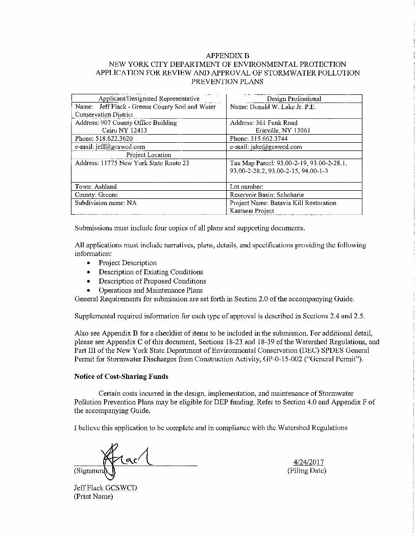

Batavia Kill Restoration at
Kastanis Project
Stormwater Pollution Prevention Plan Town of Ashland, Greene County, New York
Prepared by: Greene County Soil & Water Conservation District - Schoharie
Watershed Program
Prepared for: New York City Department of Environmental Protection –
Regulatory & Engineering Programs - WOH Stormwater Program
June 5, 2017
Project Partners and Contacts
New York City Department of Environmental Protection-Stream Management Program
71 Smith Avenue
Kingston, New York 12401
845.340.7234
Contact: Dave Burns-Project Manager
Greene County Soil &Water Conservation District
907 County Office Building
Cairo, New York 12413
518.622.3620
Contact: James Buchanan-Project Manager
ww.gcswcd.com
DuLac Engineering, Inc., P.C. 361 Funk Road
Erieville, NY 13061 315.662.3744
Contact: Donald W. Lake JR., P.E.
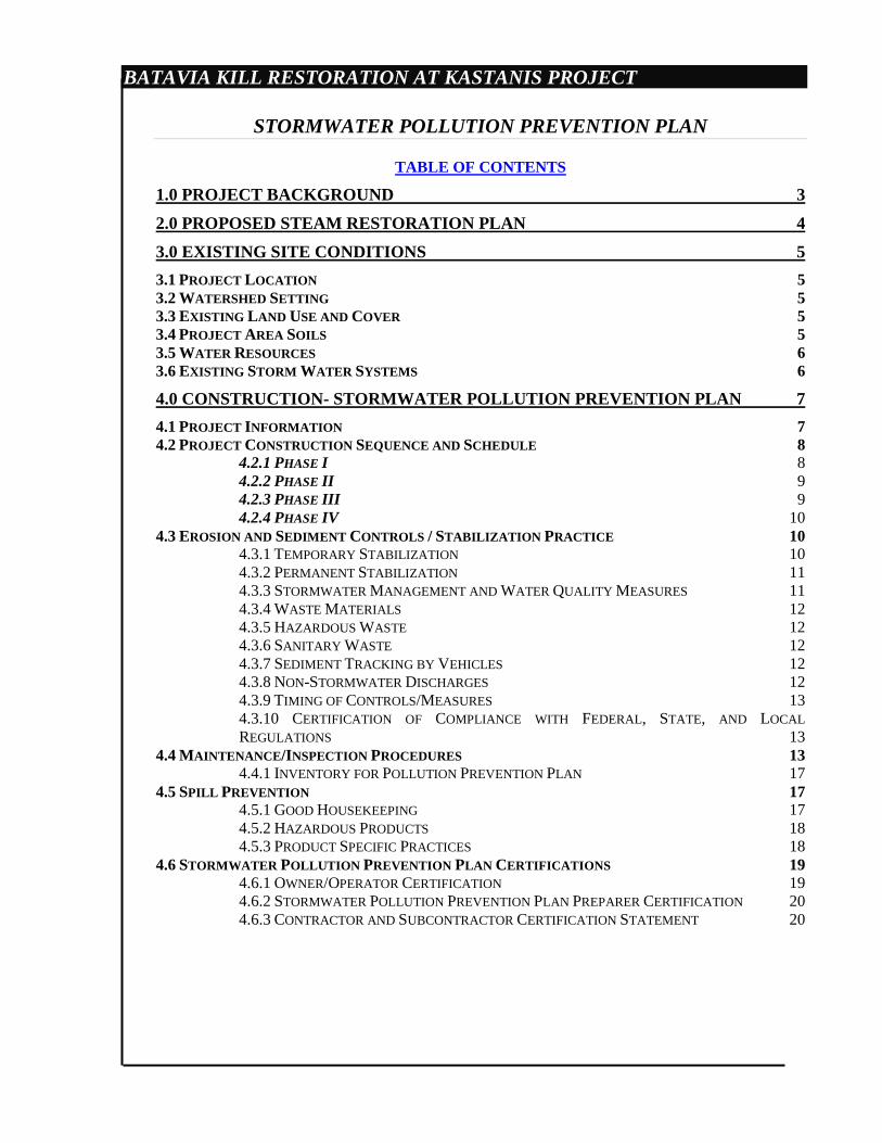
BATAVIA KILL RESTORATION AT KASTANIS PROJECT
STORMWATER POLLUTION PREVENTION PLAN
TABLE OF CONTENTS
1.0 PROJECT BACKGROUND 3
2.0 PROPOSED STEAM RESTORATION PLAN 4
3.0 EXISTING SITE CONDITIONS 5
3.1 PROJECT LOCATION 5 3.2 WATERSHED SETTING 5 3.3 EXISTING LAND USE AND COVER 5 3.4 PROJECT AREA SOILS 5 3.5 WATER RESOURCES 6 3.6 EXISTING STORM WATER SYSTEMS 6
4.0 CONSTRUCTION- STORMWATER POLLUTION PREVENTION PLAN 7
4.1 PROJECT INFORMATION 7 4.2 PROJECT CONSTRUCTION SEQUENCE AND SCHEDULE 8
4.2.1 PHASE I 8 4.2.2 PHASE II 9 4.2.3 PHASE III 9 4.2.4 PHASE IV 10
4.3 EROSION AND SEDIMENT CONTROLS / STABILIZATION PRACTICE 10 4.3.1 TEMPORARY STABILIZATION 10 4.3.2 PERMANENT STABILIZATION 11 4.3.3 STORMWATER MANAGEMENT AND WATER QUALITY MEASURES 11 4.3.4 WASTE MATERIALS 12 4.3.5 HAZARDOUS WASTE 12 4.3.6 SANITARY WASTE 12 4.3.7 SEDIMENT TRACKING BY VEHICLES 12 4.3.8 NON-STORMWATER DISCHARGES 12 4.3.9 TIMING OF CONTROLS/MEASURES 13 4.3.10 CERTIFICATION OF COMPLIANCE WITH FEDERAL, STATE, AND LOCAL
REGULATIONS 13 4.4 MAINTENANCE/INSPECTION PROCEDURES 13
4.4.1 INVENTORY FOR POLLUTION PREVENTION PLAN 17 4.5 SPILL PREVENTION 17
4.5.1 GOOD HOUSEKEEPING 17 4.5.2 HAZARDOUS PRODUCTS 18 4.5.3 PRODUCT SPECIFIC PRACTICES 18
4.6 STORMWATER POLLUTION PREVENTION PLAN CERTIFICATIONS 19 4.6.1 OWNER/OPERATOR CERTIFICATION 19 4.6.2 STORMWATER POLLUTION PREVENTION PLAN PREPARER CERTIFICATION 20 4.6.3 CONTRACTOR AND SUBCONTRACTOR CERTIFICATION STATEMENT 20
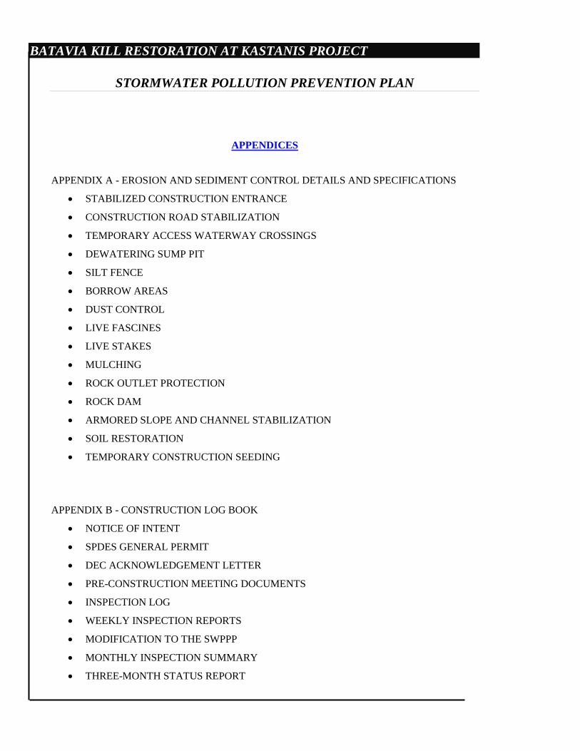
BATAVIA KILL RESTORATION AT KASTANIS PROJECT
STORMWATER POLLUTION PREVENTION PLAN
APPENDICES
APPENDIX A - EROSION AND SEDIMENT CONTROL DETAILS AND SPECIFICATIONS
STABILIZED CONSTRUCTION ENTRANCE
CONSTRUCTION ROAD STABILIZATION
TEMPORARY ACCESS WATERWAY CROSSINGS
DEWATERING SUMP PIT
SILT FENCE
BORROW AREAS
DUST CONTROL
LIVE FASCINES
LIVE STAKES
MULCHING
ROCK OUTLET PROTECTION
ROCK DAM
ARMORED SLOPE AND CHANNEL STABILIZATION
SOIL RESTORATION
TEMPORARY CONSTRUCTION SEEDING
APPENDIX B - CONSTRUCTION LOG BOOK
NOTICE OF INTENT
SPDES GENERAL PERMIT
DEC ACKNOWLEDGEMENT LETTER
PRE-CONSTRUCTION MEETING DOCUMENTS
INSPECTION LOG
WEEKLY INSPECTION REPORTS
MODIFICATION TO THE SWPPP
MONTHLY INSPECTION SUMMARY
THREE-MONTH STATUS REPORT
BATAVIA KILL RESTORATION AT KASTANIS PROJECT
STORMWATER POLLUTION PREVENTION PLAN
FINAL STABILIZATION AND RETENTION RECORDS
NYS DEC & NYC DEP COMPLIANCE INSPECTION
NOTICE OF TERMINATION
APPENDIX C - PROJECT MAPS
LOCATION MAP
LANDOWNERS MAP
SOIL TYPE MAP
APPENDIX D – PROJECT CONSTRUCTION DRAWINGS
SHEET 1 TITLE SHEET
SHEET 2 EXISTING CONDITION
SHEET 3 PROPOSED SITE PLAN INDEX
SHEET 4 PROPOSED GRADING PLAN
SHEET 5 PROPOSED GRADING PLAN
SHEET 6 PROPOSED GRADING PLAN
SHEET 7 EROSION AND SEDIMENT CONTROL INDEX
SHEET 8 EROSION AND SEDIMENT CONTROL PLAN
SHEET 9 REVEGETATION PLAN
SHEET 10 WETLAND MITIGATION PLAN
SHEET 11 STREAM CHANNEL PROFILE
SHEET 12 CROSS SECTION 6+50 – 14+00
SHEET 13 CROSS SECTION 14+50 – 22+00
SHEET 14 CROSS SECTION 22+50 – 30+00
SHEET 15 CROSS SECTION 30+50 – 39+00
SHEET 16 DETAILS
SHEET 17 DETAILS
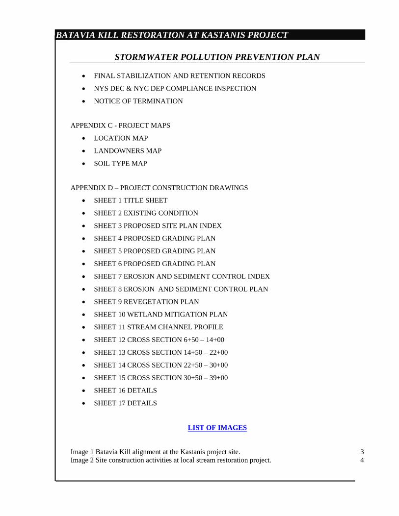
LIST OF IMAGES
Image 1 Batavia Kill alignment at the Kastanis project site. 3 Image 2 Site construction activities at local stream restoration project. 4

2
3
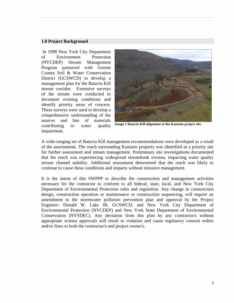
1.0 Project Background
In 1998 New York City Department
of Environment Protection
(NYCDEP) Stream Management
Program partnered with Greene
County Soil & Water Conservation
District (GCSWCD) to develop a
management plan for the Batavia Kill
stream corridor. Extensive surveys
of the stream were conducted to
document existing conditions and
identify priority areas of concern.
These surveys were used to develop a
comprehensive understanding of the
sources and fate of materials
contributing to water quality
impairment.
A wide-ranging set of Batavia Kill management recommendations were developed as a result
of the assessments. The reach surrounding Kastanis property was identified as a priority site
for further assessment and stream management. Preliminary site investigations documented
that the reach was experiencing widespread streambank erosion, impacting water quality
stream channel stability. Additional assessment determined that the reach was likely to
continue to cause these conditions and impacts without intrusive management.
It is the intent of this SWPPP to describe the construction and management activities
necessary for the contractor to conform to all federal, state, local, and New York City
Department of Environmental Protection rules and regulation. Any change in construction
design, construction operation or maintenance or construction sequencing, will require an
amendment to the stormwater pollution prevention plan and approval by the Project
Engineer- Donald W. Lake JR, GCSWCD, and New York City Department of
Environmental Protection (NYCDEP) and New York State Department of Environmental
Conservation (NYSDEC). Any deviation from this plan by any contractor/s without
appropriate written approvals will result in violation and cause regulatory consent orders
and/or fines to both the contractor/s and project owner/s.
Image 1 Batavia Kill alignment at the Kastanis project site.
4
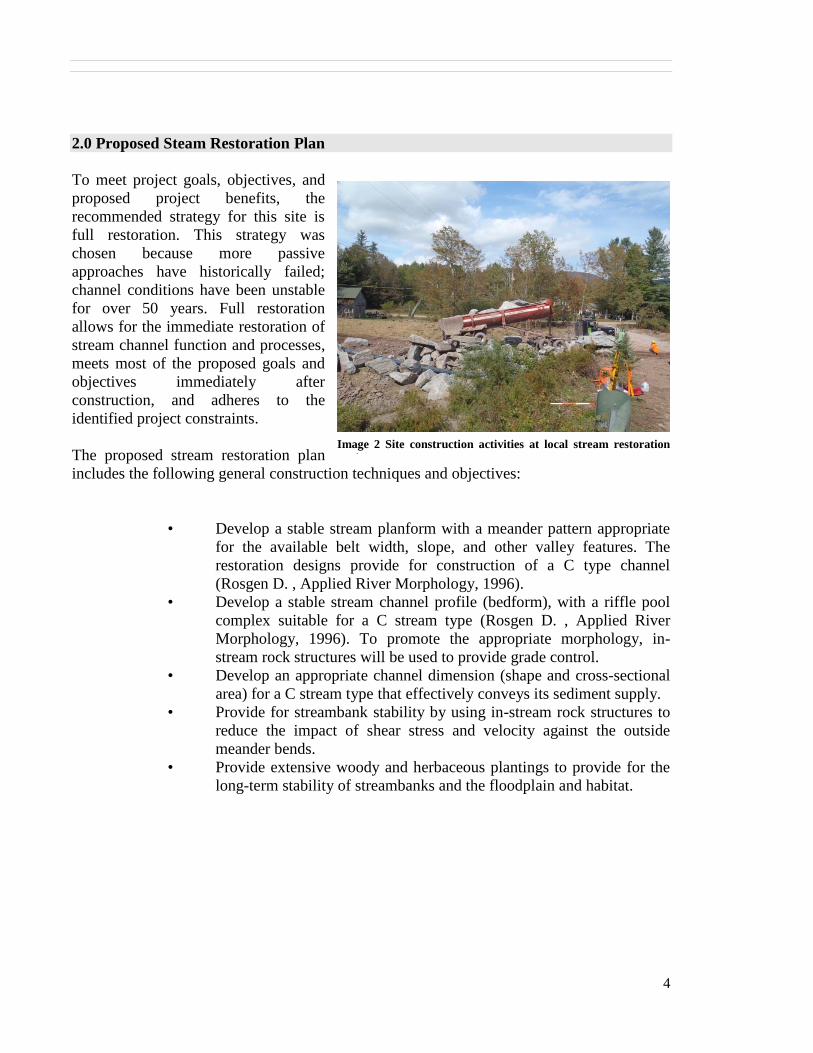
2.0 Proposed Steam Restoration Plan
To meet project goals, objectives, and
proposed project benefits, the
recommended strategy for this site is
full restoration. This strategy was
chosen because more passive
approaches have historically failed;
channel conditions have been unstable
for over 50 years. Full restoration
allows for the immediate restoration of
stream channel function and processes,
meets most of the proposed goals and
objectives immediately after
construction, and adheres to the
identified project constraints.
The proposed stream restoration plan
includes the following general construction techniques and objectives:
• Develop a stable stream planform with a meander pattern appropriate
for the available belt width, slope, and other valley features. The
restoration designs provide for construction of a C type channel
(Rosgen D. , Applied River Morphology, 1996).
• Develop a stable stream channel profile (bedform), with a riffle pool
complex suitable for a C stream type (Rosgen D. , Applied River
Morphology, 1996). To promote the appropriate morphology, in-
stream rock structures will be used to provide grade control.
• Develop an appropriate channel dimension (shape and cross-sectional
area) for a C stream type that effectively conveys its sediment supply.
• Provide for streambank stability by using in-stream rock structures to
reduce the impact of shear stress and velocity against the outside
meander bends.
• Provide extensive woody and herbaceous plantings to provide for the
long-term stability of streambanks and the floodplain and habitat.
Image 2 Site construction activities at local stream restoration
project.
5
3.0 Existing Site Conditions
The Kastanis project reach receives flow from a 52.6 square mile drainage area, which is
partially regulated by the three flood control structures located within the upper watershed.
The project reach encompassed more than 3,350 feet of stream channel and included
approximately 3,367 feet of actively eroding streambank. The project site is subject to
unstable lateral migration with average rates of 4’ a year in the center of the project since
2005. It is uncertain that the impaired condition of the streambanks would restore themselves
with time and it was suspected they were vulnerable to future runoff events. Based on these
findings, it was determined that the reach was a priority site for repair and maintenance. The
following sections further summarize the state of the reach.
3.1 Project Location
The project is located in the Town of Ashland, adjacent to New York State Route 23.
The center of the project is 120 ft. south of the intersection of State Route 23 and
Campbell Rd. The project starts approximately 700 ft. downstream of the Maier Farm
Bridge and continues downstream approximately 3,350 ft. MAP-01 displays the
project location on a USGS topographic map, and tax parcels boundaries and
landowners can be seen on map L-01 in Appendix C.
3.2 Watershed Setting
The Batavia Kill watershed is a 72 square mile sub-basin of the Schoharie drainage.
The Maier Farm project reach has the flattest valley slope of the drainage system, at
0.2%. The valley is very broad with extensive belt width available for stream channel
migration. Historic management of the Batavia Kill, including alignment
modifications, have resulted in numerous channel responses including over-widened
channels, severe bank erosion, rapid lateral migration and impacted water quality and
habitat through this valley segment.
3.3 Existing Land Use and Cover
Current land use within the project area consists of agricultural land on the North Side
of the stream and woodland (forest) on the South side of the stream. Land cover along
the streambanks of the Batavia Kill within the project site consists predominately of
the invasive Japanese knotweed.
3.4 Project Area Soils
The project site includes four soil types Barbour loam (Ba), Basher Silt Loam (Bs),
Onteora Silt Loam (OpC), and Tunkhannock Gravelly Loam (TuC). According to
the US Department of Agriculture’s Soil Survey of Greene County, New York
Barbour Loam soils are usually very deep, level (0-3% slopes), and well drained.
Basher Silt Loam Soil is very deep, nearly level (0-3% slope), and moderately well
drained. Onteora Silt Loam is very deep, with slopes 5-15%, and is somewhat poorly
6
drained. Tunkhannock Gravelly Loam is very deep, with slopes 5-16%, and is
somewhat excessively drained and well drained.
A soils map (SOIL-01) depicting the soil types within in the project limits can be
found in Appendix C.
3.5 Water Resources
Water resources on the parcel consist of the Batavia Kill, which is classified by the
New York State Department of Environmental Conservation as A(T) which means
that the resource is used as a drinking water supply and that it may support a trout
population. It is listed on the 2002 NYS DEC Priority Waterbodies List (PWL) under
HUC 02020005/020 Batavia Kill, Lower, and tributaries (1202-0001) as
Habitat/hydrology known to be stressed, Minor Impacts with a known problem
species (knotweed) and Silt/sediment as suspected pollutants. Sources of pollutants
are listed as; Known - streambank erosion and habitat modification, and Possible -
construction, and failing onsite systems. The project area is located entirely in the
FEMA 100-year flood plain.
3.6 Existing Storm Water Systems
The project area does not include any known existing storm water management
structures.
7
4.0 Construction- Stormwater Pollution Prevention Plan
This SWPP covers the complete project construction scheduled to be completed in December
2017. As proposed, the project will involve approximately 18.63 acres of total disturbance
limited to the immediate stream corridor. All post construction storm water runoff from the
project area will be consistent with the project areas existing hydrological and hydraulic
regimes. The GCSWCD will operate and maintain the project through permanent
stabilization.
This project has soil disturbances over 5 acres and requires written authorization from DEC
Regional Office.
4.1 Project Information
Project Name and Location
Batavia Kill Restoration at Kastanis Property
11775 New York State Route 23
Town of Ashland
Greene County, New York, 12407
Project Owner
Various Landowners (see map L-01 in appendix C)
Project Operator
Greene County Soil & Water Conservation District (GCSWCD)
Jeff Flack, Executive Director
907 County Office Building
Cairo, New York, 12413
518.622.3620 Phone
518.622.0344 Fax
Construction Inspector and Manager
GCSWCD (GCSWCD)
James Buchanan, CPESC
907 County Office Building
Cairo, New York, 12413
518.622.3620 Phone
518.567.0344 Fax
DuLac Engineering, Inc., P.C.
2967 Funk Road
Erieville, NY 13061
315.662.3744
Contact: Donald W. Lake JR., P.E.
8
4.2 Project Construction Sequence and Schedule
The project will involve 16.40 acres of disturbance within the grading limits. An
additional 2.13 acres of disturbance will be required for staging and access roads. The
construction will be completed in four phases.
Table 1
A phasing plan and overall construction sequencing schedule are displayed on design
sheets 7 and 8. All measures shall be installed in accordance with New York State
Standards and Specifications for Erosion and Sediment Control (November 2016). Any
change in construction design, construction operation or maintenance or construction
sequencing, will require an amendment to the storm water pollution prevention plan
and approval by the GCSWCD, Project Engineer, Contracting Officer, NYSDEC and
NYCDEP.
4.2.1 Phase I
Phase I will include the installation of project erosion and sediment controls and
the construction of stream restoration measures. The site access road and
stabilized construction entrance will also be constructed during phase I, and will
utilize a constructed access from Carrington Rd. Phase I begins at Station 6+00
and continues to Station 13+50. This phase will include a total disturbance of 5.69
acres (3.36 acres within the grading limits and 2.33 acres for access, stockpile,
and staging) and is displayed on construction plan sheet 08. Erosion and sediment
control details and notes are provided on sheet 16 and 17. Phase I Construction
Sequencing is as follows:
1. Install the stabilized construction entrance.
2. Install the phase I access road, sediment control area, and stockpile
area.
3. Install the phase I pumps, pipe lines, and outlet controls.
4. Install the phase I coffer dams.
5. Perform clearing and grubbing.
6. Perform grading and install rock toe protection.
7. Install vegetative measures of seed & mulch.
8. Remove the phase I coffer dams.
9. Remove the phase I pumps, pump lines, and outlet controls.
10. Install vegetative measures of seed and mulch.
I 3.36 2.33 5.69 7938.5 7881.489 57.011 8/17/2017 8/28/2017 12
II 4.33 1.96 6.29 20832.31 20026.19 806.117 8/29/2017 9/7/2017 10
III 4.73 1.85 6.58 11029.39 11795.04 -765.646 9/8/2017 9/18/2017 11
IV 4.10 1.10 5.2 9035.14 9343.301 -308.161 9/19/2017 9/30/2017 12
-210.679 Total 45
Days
Total
Total Cut Fill Balance Start Completion Phase
Area of Disturbance (Ac.) Grading Schedule
Grading
Area
Access Road Staging, and
Stockpile
9
Phase I bioengineering will commence in the in the fall of 2017 when plant
materials enter dormancy.
4.2.2 Phase II
Phase II will include the installation of project erosion and sediment controls and
the construction of stream restoration measures. Phase II begins at Station 13+50
and continues to Station 20+50. This phase will include the disturbance of a total
of 6.29 acres (4.33 acres within the grading limits and 1.96 acres for access,
stockpile area, and staging) and is displayed on construction plan sheet 08.
Erosion and sediment control details and notes are provided on sheet 16 and 17.
Phase II Construction Sequencing is as follows:
1. Install the phase II access road, sediment control area.
2. Install the phase II pumps, pipe lines, and outlet controls.
3. Install the phase II coffer dams.
4. Perform clearing and grubbing.
5. Perform grading and install rock toe protection.
6. Install vegetative measures of seed & mulch.
7. Remove the phase II coffer dam.
8. Remove the phase II pumps, pipe lines, and outlet controls.
9. Install vegetative measures of seed and mulch.
Phase II bioengineering will commence in the in the fall of 2017 when plant
materials enter dormancy.
4.2.3 Phase III
Phase III will include the installation of project erosion and sediment controls and
the construction of stream restoration measures. Phase III begins at Station 20+50
and continues to Station 28+00. This phase will include the disturbance of a total
of 6.58 (4.73 acres within the grading limits and 1.85 acres for access, stockpile,
and staging) acres and is displayed on construction plan sheet 08. Erosion and
sediment control details and notes are provided on sheet 16 and 17. Phase III
Construction Sequencing is as follows:
1. Install the phase III access road, sediment control area.
2. Install the phase III pumps, pipe lines, and outlet controls.
3. Install the phase III coffer dams.
4. Perform clearing and grubbing.
5. Perform grading and install rock toe protection.
6. Remove phase III coffer dams.
7. Remove phase III pumps, pipe lines, and outlet protection.
8. Install vegetative measures of seed & mulch.
10
Phase III bioengineering will commence in the in the fall of 2017 when plant
materials enter dormancy.
4.2.4 Phase IV
Phase IV will include the installation of project erosion and sediment controls and
the construction of stream restoration measures. Phase IV begins at Station 28+00
and continues to Station 39+00. This phase will include the disturbance of a total
of 5.20 acres (4.10 acres within the grading limits and 1.10 acres for access and
staging) and is displayed on construction plan sheet 08. Erosion and sediment
control details and notes are provided on sheet 16 and 17. Phase IV Construction
Sequencing is as follows:
1. Install the phase IV access road, sediment control area.
2. Install the phase IV pumps, pipe lines, and outlet controls.
3. Install the phase IV coffer dams.
4. Perform clearing and grubbing.
5. Perform grading and install rock toe protection.
6. Remove phase IV coffer dams.
7. Remove phase IV pumps, pipe lines, and outlet protection.
8. Install vegetative measures of seed & mulch.
9. Remove access road and sediment controls.
10. Perform soil restoration.
Phase IV bioengineering will commence in the in the fall of 2017 when plant
materials enter dormancy.
4.3 Erosion and Sediment Controls / Stabilization Practice
All measures shall be installed in accordance with New York State Standards and
Specifications for Erosion and Sediment Control (November 2016).
4.3.1 Temporary Stabilization
Topsoil stockpiles, staging areas and disturbed pervious portions of the project
area where construction activity temporarily ceases for at least 7 days shall be
stabilized with temporary seed and mulch no later than 7 days from the last
construction activity in that area.
Temporary seed shall be Rye (grain) applied at the rate of 30 pounds per acre.
Mulch shall be applied in conjunction with seeding and applied at the rate of 90
lbs. per 1,000 sq. ft. Mulch shall be reapplied as necessary.
11
For rapid soil stabilization onsite, an adequate supply of straw mulch and
mulching equipment will remain be onsite during all phases of construction.
Forecasted wet weather will be monitored daily by GCSWCD staff.
Rip-rap outlet protection shall be installed at all pump and pipe line outlets. Rip-
rap material shall be hard, durable field or quarry stone which is angular and
resists breaking down when exposed to water or weathering.
Sediment control fencing shall be installed around the site where depicted on the
attached plan sheets. Sediment control fencing shall be “dug-in” using a narrow
ditch witch device. Prior to commencing any earthwork, a stabilized construction
entrance shall be installed as indicated on the attached plans. This entrance shall
be utilized as the exclusive construction entrance and exit to the construction
areas.
4.3.2 Permanent Stabilization
Disturbed portions of the project area where construction activities permanently
cease shall be stabilized with permanent seed no later than 7 days after the last
construction activity. The permanent seed mix shall be in accordance with the
project specifications and plans. Construction and maintenance of erosion and
siltation control measures are in accordance with the New York Standards and
Specifications for Erosion and Sediment Control (November 2016).
Where construction activity is complete, over areas to be permanently vegetated,
stabilize with permanent seeding. Evenly apply seed in accordance with the rate
indicated in section 02910 “planting” of the project manual. Verify seeding dates
with engineer and project manager. If the project engineer determines that seed
cannot be applied due to climate, topsoil shall not be spread and mulching shall be
applied to the exposed surface to stabilize soils until the next recommended
seeding period.
Final stabilization is achieved when an 80% germination of the perennial
vegetation is reached.
4.3.3 Stormwater Management and Water Quality Measures
The proposed project enhances vegetative cover, and proposes no increase in
impervious surface. Soil characteristics will remain unchanged, as well as local
drainage and surface hydrology. These attributes waive the need for permanent
storm water quality controls, and requirements for extended detention of the 1-
year 24-hour storm and mitigation of the peak flows from the 10-year and 100-
year 24-hour storm events (New York State Department of Environmental
Conservation, 2010).
12
Soil restoration should be performed on all disturbed areas in accordance with the
project specifications in appendix A of this document, and design sheet 09
“Revegetation Plan”.
4.3.4 Waste Materials
Foreign waste materials shall be collected and stored in a secured area until
removal and disposal by a licensed solid waste management company. All trash
and construction debris from the project area shall be disposed of in a portable
container unit. No foreign waste materials shall be buried within the project area.
All personnel shall be instructed regarding the correct procedure for waste
disposal. Notices stating these practices shall be posted in the project trailer and
the individual who manages day-to-day project operations will be responsible for
seeing that these procedures are followed.
4.3.5 Hazardous Waste
All hazardous waste materials shall be disposed of in a manner specified by local
or state regulations or by the manufacturer. Project personnel shall be instructed
in these practices and the individual who manages day-to-day project operations
shall be responsible for seeing that these practices are followed.
4.3.6 Sanitary Waste
Any sanitary waste from portable units shall be collected from the portable units
by a licensed sanitary waste management contractor, as required by NYS DEC
regulations.
4.3.7 Sediment Tracking by Vehicles
The site will be accessed from a constructed entrance located at 71 Carrington Rd.
The entrance will be maintained as necessary to help reduce vehicular tracking of
sediment. The entrance shall be cleaned of sediment and redressed when voids in
the crushed stone become filled and vehicular tracking of sediment is occurring.
Dump trucks hauling materials to and from the construction project area shall be
covered with a tarpaulin to reduce dust. Any sediment and debris tracked from
work area along project adjacent roadways shall be immediately removed with a
street sweeper or equivalent sweeping method.
4.3.8 Non-Stormwater Discharges
Non-Stormwater discharges are not expected to exit the project area during
construction.
13
4.3.9 Timing of Controls/Measures
The erosion and sediment control measures shall be constructed prior to clearing
or grading of any portion of the project. Where construction activity temporarily
ceases for more than 7 days, areas to be vegetated shall be stabilized with a
temporary seed and mulch within 7 days of the last disturbance. Once
construction activity ceases permanently in an area, that area shall be stabilized
with permanent measures. After the entire project area is stabilized, the
accumulated sediment shall be removed from the project area. Erosion control
devices shall remain in place until disturbed areas are permanently stabilized.
4.3.10 Certification of Compliance with Federal, State, and Local Regulations
The stormwater pollution prevention plan reflects the New York State
requirements for stormwater management and erosion and sediment control. To
ensure compliance, this plan was prepared in accordance with New York State
standards, and plan review and approval by NYCDEP.
4.4 Maintenance/Inspection Procedures
These are the minimum required inspection and maintenance practices that shall
be used to maintain erosion and sediment controls:
For the project site all control measures shall be inspected at least once
each week using the “Construction Duration Inspection Form” referenced
from Appendix H of the New York State Standards and Specifications for
Erosion and Sediment Control. A copy of this form is included in the
“inspection reports” section of this plan. GCSWCD will perform these
inspections.
A copy of the SWPPP must be posted onsite, in a publicly accessible
location.
A summary of the project area inspection activities shall be posted
monthly in a publicly accessible location. A copy of the “Monthly
Inspection Summary Form” is included in the “inspection forms” section
of this plan. The Qualified Inspector, at a minimum, will inspect all
erosion and sediment control practices to ensure integrity and
effectiveness, all post-construction stormwater management practices
under construction to ensure that they are constructed in conformance with
the SWPPP, all areas of disturbance that have not achieved final
stabilization, and all points of discharge from the construction site. The
Qualified Inspector will prepare an inspection report subsequent to each
and every inspection. An inspection report should be kept in a site logbook
14
and will be maintained on-site and be made available to the permitting
authority upon request.
o At a minimum, the inspection report will include and/or address
the following:
(a.) Date and time of inspection;
(b.) Name and title of person(s) performing inspection;
(c.) A description of the weather and soil conditions (e.g.
dry, wet, saturated) at the time of the inspection;
(d.) A description of the condition of the runoff at all points
of discharge from the construction site. This will include
identification of any discharges of sediment from the
construction site, discharges from conveyance systems (i.e.
pipes, culverts, ditches, etc.) and overland flow;
(e.) A description of the condition of all natural surface
water bodies located within, or immediately adjacent to, the
property boundaries of the construction site which receive
runoff from disturbed areas. This will include identification
of any discharges of sediment to the surface water body;
(f.) Identification of all erosion and sediment control
practices that need repair or maintenance;
(g.) Identification of all erosion and sediment control
practices that were not installed properly or are not
functioning as designed and need to be reinstalled or
replaced;
(h.) Description and sketch of areas on a site plan or map
that are disturbed at the time of the inspection, the total
acreage disturbed at the time of inspection and areas that
have been stabilized (temporary and/or final) since the last
inspection;
(i.) Current phase of construction of all post-construction
stormwater management practices and identification of all
construction that is not in conformance with the SWPPP
and the State’s technical standards;
(j.) Corrective action(s) that must be taken to install, repair,
replace or maintain erosion and sediment control practices;
and to correct deficiencies identified with the construction
of the post-construction stormwater management
practice(s).
15
(k.) Digital photographs, with date stamp, that clearly show
the condition of all practices that have been identified as
needing corrective actions. The Qualified Inspector will
attach paper color copies of the digital photographs to the
inspection report that documents the completion of the
corrective action work within seven (7) calendar days of
that inspection.
As per GP-0-15-002, site inspections will be conducted twice weekly
separated by a minimum of two business days and within one business day
of a significant rainfall event (0.5" or greater). The Qualified Inspector
will provide inspection reports two (2) times per week and within 24 hours
of any rainfall of 0.5 inches or more. All inspection reports will be signed
by the Qualified Inspector. The inspection reports will be maintained on
site with the SWPPP. In addition, a copy of each inspection report will be
submitted to the Regional Office stormwater contact person (Jeffrey
McCullough) by electronic mail to [email protected]. The
inspection reports will be submitted within two (2) business days of the
date the inspection is performed
Within one business day of the completion of an inspection, the Qualified
Inspector will notify the permittee and appropriate contractor (or
subcontractor) of any corrective actions that need to be taken. The
contractor (or subcontractor) will begin implementing the corrective
actions within one business day of this notification and will complete the
corrective actions in a reasonable time frame. Unless otherwise notified by
the Department, the permittee will amend the SWPPP whenever the
provisions of the SWPPP prove to be ineffective in eliminating or
significantly minimizing pollutants in stormwater discharges from the site;
whenever there is a change in design, construction, operation, or
maintenance at the construction site that has or could have a significant
effect on the discharge of pollutants; and to address issues or deficiencies
identified during an inspection by the Qualified Inspector, the Department
or other regulatory authority. The permittee will notify the Regional
Office stormwater contact person (Jeffrey McCullough) in writing of each
amendment to the SWPPP within five (5) business days of the
identification/observation of a SWPPP deficiency.
The operator shall prepare a written summary of the SWPPP’s status with
respect to compliance with the general permit (GP-015-002) at a minimum
frequency of every three months during which coverage under the permit
exists. The summary should address the status of achieving each
16
component of the SWPPP. A copy of the “Monitoring, Reporting and
Three-Month Status Inspection Form”, referenced from Appendix H of the
New York State Standards and Specifications for Erosion and Sediment
Control, is included in the “inspection forms” section of this plan.
Prior to filing of the Notice of Termination or the end of permit term, the
Operator shall perform a final project area inspection. This inspection
shall certify that the project area has undergone final stabilization using
either vegetative or structural stabilization methods and that all temporary
erosion and sediment controls (such as silt fencing) not needed for long-
term erosion control have been removed. A copy of the “Final
Stabilization and Retention of Records Inspection Form”, referenced from
Appendix H of the New York Standards and Specifications for Erosion
and Sediment Control, is included in the “inspection forms” section of this
plan.
All measures shall be maintained in good working order; if a repair is
necessary, it will be initiated within 24 hours of report or as ordered by the
owner’s representatives.
Built up sediment shall be removed from any silt fence when it has
reached one-third the height of the fence / dike.
Sediment control fencing and wetland protection barrier shall be inspected
for depth of sediment, and tears, to see if fabric is securely attached to the
fence posts, and to see that the fence posts are firmly in the ground.
The construction entrance shall be cleaned of sediment and redressed
when voids in the crushed stone become filled and vehicular tracking of
sediment is occurring.
Dust shall be controlled on access points and other disturbed areas subject
to surface dust movement and blowing.
Stabilization fabric and rock dams shall be inspected to ensure that slopes
and swales are not being eroded. Fabric shall be replaced / reinstalled and
rock dams added as necessary to prevent any such erosion
The temporary sediment basin shall be inspected to check condition of
basin.
Inspection must verify that all practices are adequately operational,
maintained properly and that sediment is removed from all control
structures.
Inspection must look for evidence of soil erosion on the site, potential for
pollutants entering drainage systems, problems at the discharge points, and
signs of soil and mud transport from the site to the public road.
17
The site operator or superintendent shall select the individuals who will be
responsible for the inspections, maintenance, repair activities, and filling
out the inspection and maintenance report.
Personnel selected for inspection and maintenance responsibilities shall
have received proper training in all the inspection and maintenance
practices necessary for keeping the erosion and sediment controls used on-
site in good working order.
The operator shall retain copies of SWPPP’s, any reports submitted in
conjunction with this permit and records of all data used to complete the
NOI to be covered by this permit for a period of at least three years from
the date that the site is finally stabilized.
4.4.1 Inventory for Pollution Prevention Plan
The materials or substances listed below are expected to be within the project area
during construction:
Fertilizers / seeding materials.
Stone.
Large Rock.
Concrete.
Petroleum based products.
Silt fence fabric.
Lumber.
CMP.
Plastic Pipe.
Cellulose fiber mulch.
Straw/hay mulch
Anchoring chemicals
4.5 Spill Prevention
The following are the material management practices that shall be used to reduce the
risk of spills or other accidental exposure of materials and substances to stormwater
runoff.
4.5.1 Good Housekeeping
The following good housekeeping practices shall be followed within project areas
during construction:
18
An effort shall be made to store only enough products required to do the
job.
All materials stored within project areas shall be stored in a neat, orderly
manner in their appropriate containers and, if possible, under a roof or
other enclosure.
Products shall be kept in their original containers with the original
manufacturer's label.
Substances shall not be mixed with one another unless recommended by
the manufacturer.
Whenever possible, all of a product shall be used up before disposing of
the container.
Manufacturers' recommendations for proper use and disposal shall be
followed.
The project superintendent shall inspect daily to ensure proper use and
disposal of materials.
4.5.2 Hazardous Products
These practices are used to reduce the risks associated with hazardous materials:
Products shall be kept in original containers unless they are not re
sealable.
Original labels and material safety data shall be retained.
If surplus product must be disposed of, manufacturers' or local and state
recommended methods of proper disposal shall be followed.
Material Safety Data Sheets for all hazardous products shall be within the
project area for the duration of construction.
4.5.3 Product Specific Practices
The following product-specific practices shall be followed within the project
areas:
Petroleum Products
All project related vehicles shall be monitored for leaks and receive regular
preventive maintenance to reduce the chance of leakage. Petroleum products
shall be stored in tightly sealed containers which are clearly labeled.
Fertilizers
Fertilizers used shall be applied only in the minimum amounts recommended by
the manufacturer. Once applied, fertilizer shall be worked into the soil to limit
19
exposure to stormwater. Fertilizers shall be stored in a covered or other contained
area.
Spill Control Practices
The contractor will be responsible adhere to a project area specific spill
control plan in accordance with local, NYCDEP and NYSDEC regulations. A
spill kit will be on site and these requirements are part of the projects Health
and Safety Plan. At a minimum this plan should:
Reduce stormwater contact if there is a spill.
Contain the spill.
Stop the source of the spill.
Dispose of contaminated material in accordance with manufactures
procedures, and NYS DEC regulations.
Identify responsible and trained personnel.
Ensure spill area is well ventilated.
4.6 Stormwater Pollution Prevention Plan Certifications
4.6.1 Owner/Operator Certification
I have read or been advised of the permit conditions and believe that I understand
them. I also understand that, under the terms of the permit, there may be reporting
requirements. I hereby certify that this document and the corresponding
documents were prepared under my direction or supervision. I am aware that
there are significant penalties for submitting false information, including the
possibility of fine and imprisonment for knowing violations. I further understand
that coverage under the general permit will be identified in the acknowledgment
that I will receive as a result of submitting this NOI and can be as long as sixty
(60) business days as provided for in the general permit. I also understand that, by
submitting this NOI, I am acknowledging that the SWPPP has been developed
and will be implemented as the first element of construction, and agreeing to
comply with all the terms and conditions of the general permit for which this NOI
is being submitted (New York State Department of Environmental Conservation,
2015).
Name: Jeff Flack
Owner/Operator Signature:
Date:
20
4.6.2 Stormwater Pollution Prevention Plan Preparer Certification
I hereby certify that the Stormwater Pollution Prevention Plan (SWPPP) for this
project has been prepared in accordance with the terms and conditions of the GP-
0-15-002. Furthermore, I understand that certifying false, incorrect or inaccurate
information is a violation of this permit and the laws of the State of New York
and could subject me to criminal, civil and/or administrative proceedings (New
York State Department of Environmental Conservation, 2015).
Name: James Buchanan
Preparer Signature:
Title: GCSWCD Project Manager/ CPESC
Date:
4.6.3 Contractor and Subcontractor Certification Statement
CONTRACTOR and SUBCONTRACTOR CERTIFICATION STATEMENT for
the New York State Department of Environmental Conservation (DEC) State
Pollutant Discharge Elimination System Permit for Stormwater Discharges from
Construction Activity (GP-0-15-002)
As per Part III.A.6 on page 19 of GP-0-15-002 (effective January 29, 2015):
‘Prior to the commencement of construction activity, the owner or operator must
identify the contractor(s) and subcontractor(s) that will be responsible for
installing, constructing, repairing, replacing, inspecting and maintaining the
erosion and sediment control practices included in the SWPPP; and the
contractor(s) and subcontractor(s) that will be responsible for constructing the
post-construction stormwater management practices included in the SWPPP. The
owner or operator shall have each of the contractors and sub-contractors identify
at least one person from their company that will be responsible for
implementation of the SWPPP. This person shall be known as the trained
contractor. The owner or operator shall ensure that at least one trained contractor
is on site on a daily basis when soil disturbance activities are being performed.’
The owner or operator shall have each contractor and subcontractor involved in
soil disturbance sign a copy of the following certification statement before they
commence any construction activity:
NYR:
Name of Construction Site: Batavia Kill Restoration at Kastanis Property
21
DEC Permit ID:
Municipality:
"I hereby certify that I understand and agree to comply with the terms and
conditions of the SWPPP and agree to implement any corrective actions identified
by the qualified inspector during a site inspection. I also understand that the
owner or operator must comply with the terms and conditions of the most current
version of the New York State Pollutant Discharge Elimination System
("SPDES") general permit for stormwater discharges from construction activities
and that it is unlawful for any person to cause or contribute to a violation of water
quality standards. Furthermore, I understand that certifying false, incorrect or
inaccurate information is a violation of the referenced permit and the laws of the
State of New York and could subject me to criminal, civil and/or administrative
proceedings (New York State Department of Environmental Conservation, 2015).
Responsible Corporate Officer/Partner Signature:
Name of above Signatory:
Title of above Signatory:
Date:
Name of Company:
Mailing Address:
City, State and Zip:
Telephone of Company:
Identify the specific elements of the SWPPP the contractor or subcontractor is
responsible for:
22
‘TRAINED CONTRACTOR’ FOR THE CERTIFIED CONTRACTOR OR
SUBCONTRACTOR
Name of Trained Employee:
Title of Trained Employee:
NYSDEC SWT #:
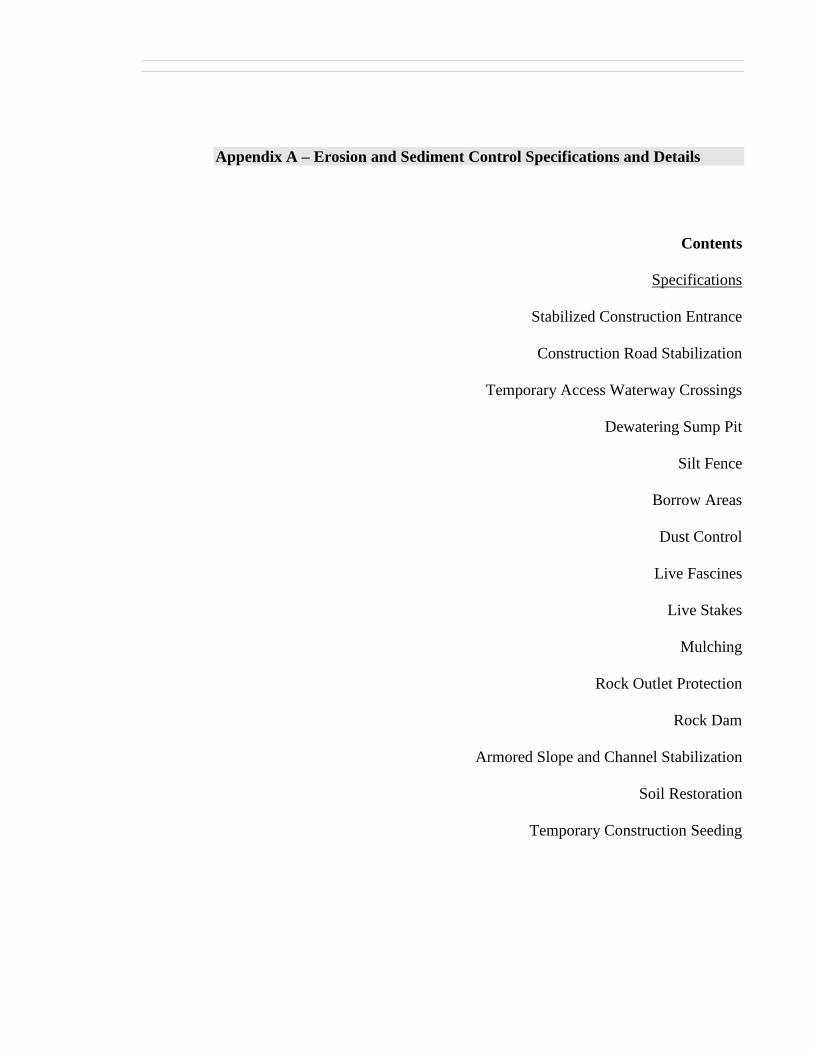
Appendix A – Erosion and Sediment Control Specifications and Details
Contents
Specifications
Stabilized Construction Entrance
Construction Road Stabilization
Temporary Access Waterway Crossings
Dewatering Sump Pit
Silt Fence
Borrow Areas
Dust Control
Live Fascines
Live Stakes
Mulching
Rock Outlet Protection
Rock Dam
Armored Slope and Channel Stabilization
Soil Restoration
Temporary Construction Seeding

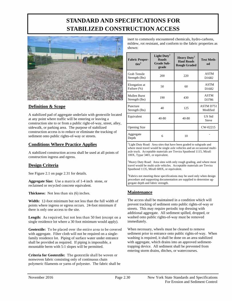
November 2016 Page 2.30 New York State Standards and Specifications For Erosion and Sediment Control
Definition & Scope A stabilized pad of aggregate underlain with geotextile located at any point where traffic will be entering or leaving a construction site to or from a public right-of-way, street, alley, sidewalk, or parking area. The purpose of stabilized construction access is to reduce or eliminate the tracking of sediment onto public rights-of-way or streets.
Conditions Where Practice Applies A stabilized construction access shall be used at all points of construction ingress and egress.
Design Criteria See Figure 2.1 on page 2.31 for details. Aggregate Size: Use a matr ix of 1-4 inch stone, or reclaimed or recycled concrete equivalent. Thickness: Not less than six (6) inches. Width: 12-foot minimum but not less than the full width of points where ingress or egress occurs. 24-foot minimum if there is only one access to the site. Length: As required, but not less than 50 feet (except on a single residence lot where a 30 foot minimum would apply). Geotextile: To be placed over the entire area to be covered with aggregate. Filter cloth will not be required on a single-family residence lot. Piping of surface water under entrance shall be provided as required. If piping is impossible, a mountable berm with 5:1 slopes will be permitted. Criteria for Geotextile: The geotextile shall be woven or nonwoven fabric consisting only of continuous chain polymeric filaments or yarns of polyester. The fabric shall be
inert to commonly encountered chemicals, hydro-carbons, mildew, rot resistant, and conform to the fabric properties as shown:
Maintenance
The access shall be maintained in a condition which will prevent tracking of sediment onto public rights-of-way or streets. This may require periodic top dressing with additional aggregate. All sediment spilled, dropped, or washed onto public rights-of-way must be removed immediately. When necessary, wheels must be cleaned to remove sediment prior to entrance onto public rights-of-way. When washing is required, it shall be done on an area stabilized with aggregate, which drains into an approved sediment-trapping device. All sediment shall be prevented from entering storm drains, ditches, or watercourses.
STANDARD AND SPECIFICATIONS FOR STABILIZED CONSTRUCTION ACCESS
Fabric Proper-ties3
Light Duty1 Roads
Grade Sub-grade
Heavy Duty2 Haul Roads
Rough Graded
Test Meth-od
Grab Tensile Strength (lbs)
200 220 ASTM D1682
Elongation at Failure (%)
50 60 ASTM D1682
Mullen Burst Strength (lbs)
190 430 ASTM D3786
Puncture Strength (lbs)
40 125 ASTM D751
Modified
Equivalent 40-80 40-80
US Std Sieve
Opening Size CW-02215
Aggregate Depth
6 10 -
1Light Duty Road: Area sites that have been graded to subgrade and where most travel would be single axle vehicles and an occasional multi-axle truck. Acceptable materials are Trevira Spunbond 1115, Mirafi 100X, Typar 3401, or equivalent. 2Heavy Duty Road: Area sites with only rough grading, and where most travel would be multi-axle vehicles. Acceptable materials are Trevira Spunbond 1135, Mirafi 600X, or equivalent. 3Fabrics not meeting these specifications may be used only when design procedure and supporting documentation are supplied to determine ag-gregate depth and fabric strength.
New York State Standards and Specifications Page 2.31 November 2016 For Erosion and Sediment Control
Figure 2.1 Stabilized Construction Access
New York State Standards and Specifications Page 2.23 November 2016 For Erosion and Sediment Control
Definition & Scope The stabilization of temporary construction access routes, on-site vehicle transportation routes, and construction parking areas to control erosion on temporary construction routes and parking areas. Conditions Where Practice Applies All traffic routes and parking areas for temporary use by construction traffic. Design Criteria Construction roads should be located to reduce erosion potential, minimize impact on existing site resources, and maintain operations in a safe manner. Highly erosive soils, wet or rocky areas, and steep slopes should be avoided. Roads should be routed where seasonal water tables are deeper than 18 inches. Surface runoff and control should be in accordance with other standards. Road Grade – A maximum grade of 12% is recommended, although grades up to 15% are possible for short distances. Road Width – 12 foot minimum for one-way traffic or 24 foot minimum for two-way traffic. Side Slope of Road Embankment – 2:1 or flatter. Ditch Capacity – On-site roadside ditch and culvert capacities shall be the 10 yr. peak runoff.
Composition – Use a 6-inch layer of NYS DOT sub-base Types 1,2,3, 4 or equivalent as specified in NYSDOT Standard Specifications. Construction Specifications
1. Clear and strip roadbed and parking areas of all vegetation, roots, and other objectionable material.
2. Locate parking areas on naturally flat areas as available. Keep grades sufficient for drainage, but not more than 2 to 3 percent.
3. Provide surface drainage and divert excess runoff to stabilized areas.
4. Maintain cut and fill slopes to 2:1 or flatter and stabilized with vegetation as soon as grading is accomplished.
5. Spread 6-inch layer of sub-base material evenly over the full width of the road and smooth to avoid depressions.
6. Provide appropriate sediment control measures to prevent offsite sedimentation.
Maintenance Inspect construction roads and parking areas periodically for condition of surface. Top dress with new gravel as needed. Check ditches for erosion and sedimentation after rainfall events. Maintain vegetation in a healthy, vigorous condition. Areas producing sediment should be treated immediately.
STANDARD AND SPECIFICATIONS FOR CONSTRUCTION ROAD STABILIZATION
November 2016 Page 2.32 New York State Standards and Specifications For Erosion and Sediment Control
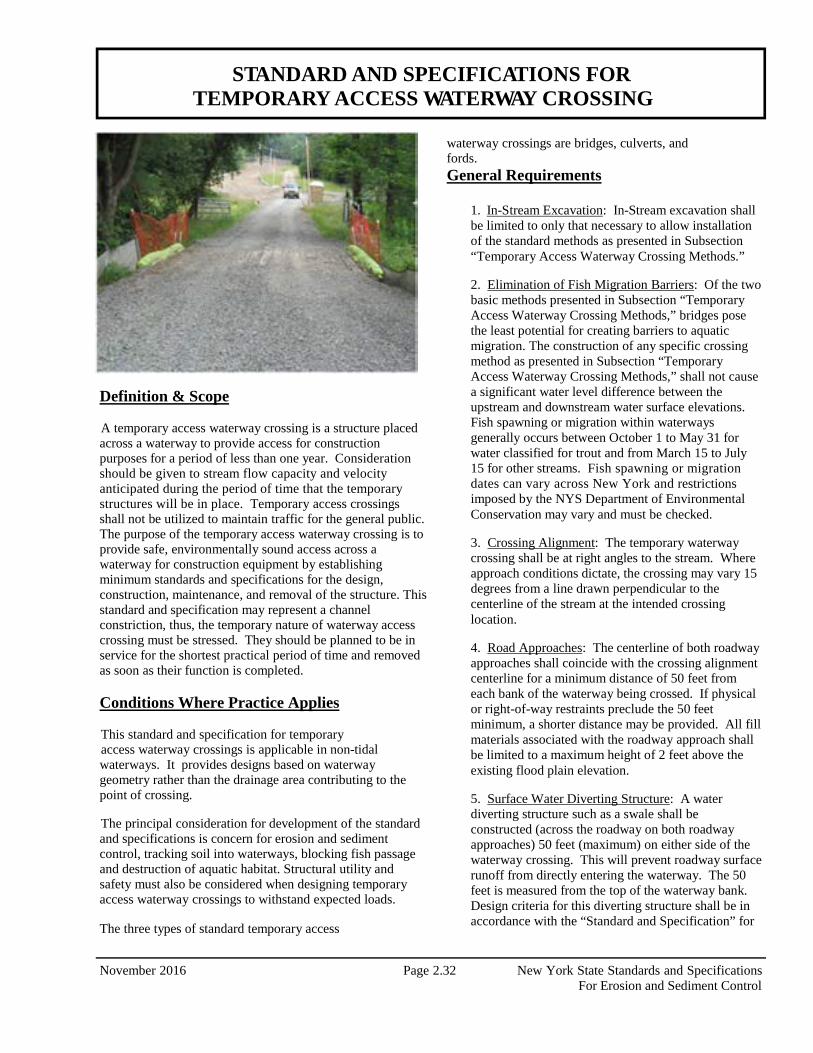
Definition & Scope A temporary access waterway crossing is a structure placed across a waterway to provide access for construction purposes for a period of less than one year. Consideration should be given to stream flow capacity and velocity anticipated during the period of time that the temporary structures will be in place. Temporary access crossings shall not be utilized to maintain traffic for the general public. The purpose of the temporary access waterway crossing is to provide safe, environmentally sound access across a waterway for construction equipment by establishing minimum standards and specifications for the design, construction, maintenance, and removal of the structure. This standard and specification may represent a channel constriction, thus, the temporary nature of waterway access crossing must be stressed. They should be planned to be in service for the shortest practical period of time and removed as soon as their function is completed. Conditions Where Practice Applies This standard and specification for temporary access waterway crossings is applicable in non-tidal waterways. It provides designs based on waterway geometry rather than the drainage area contributing to the point of crossing. The principal consideration for development of the standard and specifications is concern for erosion and sediment control, tracking soil into waterways, blocking fish passage and destruction of aquatic habitat. Structural utility and safety must also be considered when designing temporary access waterway crossings to withstand expected loads. The three types of standard temporary access
waterway crossings are bridges, culverts, and fords. General Requirements
1. In-Stream Excavation: In-Stream excavation shall be limited to only that necessary to allow installation of the standard methods as presented in Subsection “Temporary Access Waterway Crossing Methods.”
2. Elimination of Fish Migration Barriers: Of the two basic methods presented in Subsection “Temporary Access Waterway Crossing Methods,” bridges pose the least potential for creating barriers to aquatic migration. The construction of any specific crossing method as presented in Subsection “Temporary Access Waterway Crossing Methods,” shall not cause a significant water level difference between the upstream and downstream water surface elevations. Fish spawning or migration within waterways generally occurs between October 1 to May 31 for water classified for trout and from March 15 to July 15 for other streams. Fish spawning or migration dates can vary across New York and restrictions imposed by the NYS Department of Environmental Conservation may vary and must be checked.
3. Crossing Alignment: The temporary waterway crossing shall be at right angles to the stream. Where approach conditions dictate, the crossing may vary 15 degrees from a line drawn perpendicular to the centerline of the stream at the intended crossing location.
4. Road Approaches: The centerline of both roadway approaches shall coincide with the crossing alignment centerline for a minimum distance of 50 feet from each bank of the waterway being crossed. If physical or right-of-way restraints preclude the 50 feet minimum, a shorter distance may be provided. All fill materials associated with the roadway approach shall be limited to a maximum height of 2 feet above the existing flood plain elevation.
5. Surface Water Diverting Structure: A water diverting structure such as a swale shall be constructed (across the roadway on both roadway approaches) 50 feet (maximum) on either side of the waterway crossing. This will prevent roadway surface runoff from directly entering the waterway. The 50 feet is measured from the top of the waterway bank. Design criteria for this diverting structure shall be in accordance with the “Standard and Specification” for
STANDARD AND SPECIFICATIONS FOR TEMPORARY ACCESS WATERWAY CROSSING
New York State Standards and Specifications Page 2.33 November 2016 For Erosion and Sediment Control
the individual design standard of choice. If the roadway approach is constructed with a reverse grade away from the waterway, a separate diverting structure is not required.
6. Road Width: All crossings shall have one traffic lane. The minimum width shall be 12 feet with a maximum width of 20 feet.
7. Time of Operation: All temporary crossing shall be removed within 14 calendar days after the structure is no longer needed. Unless prior written approval is obtained, all structures shall be removed within one year from the date of the installation.
8. Materials
A. Aggregate: There shall be no earth or soil materials used for construction within the waterway channel. NYS DOT specifications for coarse aggregate designation No. 4 (2” to 4”), also referenced as AASHTO designation No. 1, shall be the minimum acceptable aggregate size for temporary crossings. Larger aggregates will be allowed.
B. Filter Cloth: Filter cloth is a fabric consisting of either woven or nonwoven plastic, polypropylene, or nylon used to distribute the load, retain fines, allow increased drainage of the aggregate and reduce mixing of the aggregate with the subgrade soil. The designer shall specify the appropriate filter fabric/cloth for a specific use.
Temporary Access Waterway Crossing Methods The following criteria for erosion and sediment control shall be considered when selecting a specific temporary access waterway crossing standard method:
1. Site aesthetics: Select a standard design method that will least disrupt the existing terrain of the stream reach. Consider the effort that will be required to restore the area after the temporary crossing is removed.
2. Site location: Locate the temporary crossing where there will be the least disturbance to the soils of the existing waterway banks. When possible, locate the crossing at a point receiving minimal surface runoff.
3. Physical site constraints: The physical constraints of a site may preclude the selection of one or more of the standard methods.
4. Time of year: The time of year may preclude the selection of one or more of the standard methods due to fish spawning or migration restrictions.
5. Vehicular loads and traffic patterns: Vehicular loads, traffic patterns, and frequency of crossing should be considered in choosing a specific method.
6. Maintenance of crossing: The standard methods will require various amounts of maintenance. The bridge method should require the least maintenance, whereas the ford method will probably require more intensive maintenance.
7. Removal of the Structure: Ease of removal and subsequent damage to the waterway should be primary factors in considering the choice of a standard method.
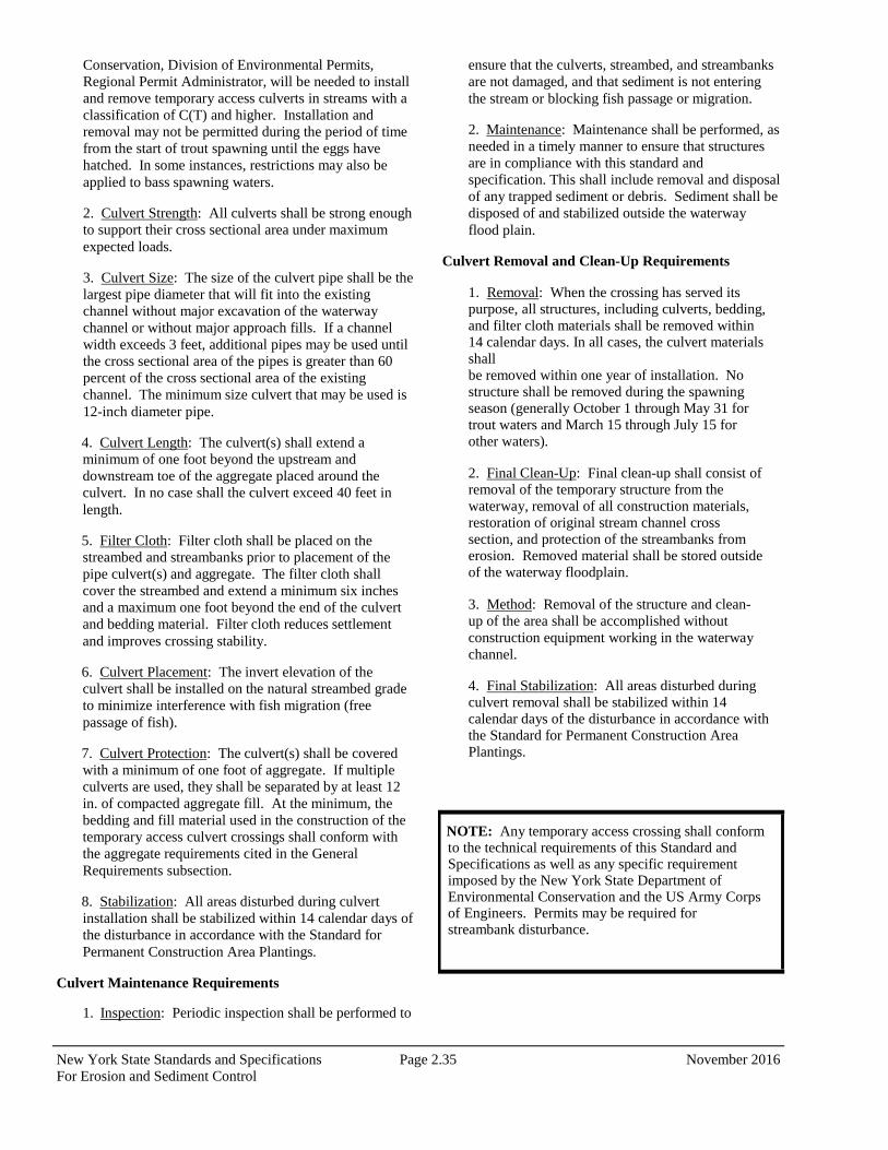
Temporary Access Bridge (Figure 2.2 on page 2.36) A temporary access bridge is a structure made of wood, metal, or other materials, which provides access across a stream or waterway. Considerations:
1. This is the preferred method for temporary access waterway crossings. Normally, bridge construction causes the least disturbance to the waterway bed and banks when compared to the other access waterway crossings.
2. Most bridges can be quickly removed and reused.
3. Temporary access bridges pose the least chance for interference with fish migration when compared to the other temporary access waterway crossings.
4. Span width will be limited by the length of the bridging material and weight of equipment that will drive over the temporary bridge. Spans of over 10 feet are difficult to construct.
5. Restrictions and Permits: A permit from the New York State Department of Environmental Conservation, Division of Environmental Permits, Regional Permit Administrator, will be needed to install and remove temporary access culverts in streams with a classification of C(T) and higher. Installation and removal may not be permitted during the period of time from the start of trout spawning until the eggs have hatched. In some instances, restrictions may also be applied to bass spawning waters.
Construction Specifications:
1. Restriction: Construction, use, or removal of a temporary access bridge will not normally have any time of year restrictions if construction, use, or
November 2016 Page 2.34 New York State Standards and Specifications For Erosion and Sediment Control
removal does not disturb the stream or its banks.
2. Bridge Placement: A temporary bridge structure shall be constructed at or above bank elevation to prevent the entrapment of floating materials and debris.
3. Abutments: Abutments shall be placed parallel to and on stable banks.
4. Bridge Span: Bridges shall be constructed to span the entire channel. If a footing, pier, or bridge support is constructed within the waterway, a stream- disturbance permit may be required.
5. Stringers: Stringers shall either be logs, saw timber, pre-stressed concrete beams, metal beams, or other approved materials.
6. Deck Material: Decking shall be of sufficient strength to support the anticipated load. All decking members shall be placed perpendicular to the stringers, butted tightly, and securely fastened to the stringers. Decking materials must be butted tightly to prevent any soil material tracked onto the bridge from falling into the waterway below.
7. Run Planks (optional): Run planking shall be securely fastened to the length of the span. One run plank shall be provided for each track of the equipment wheels. Although run planks are optional, they may be necessary to properly distribute loads.
8. Curbs or Fenders: Curbs or fenders may be installed along the outer sides of the deck. Curbs or fenders are an option, which will provide additional safety.
9. Bridge Anchors: Bridges shall be securely anchored at only one end using steel cable or chain. Anchoring at only one end will prevent channel obstruction in the event that floodwaters float the bridge. Acceptable anchors are large trees, large boulders, or driven steel anchors. Anchoring shall be sufficient to prevent the bridge from floating downstream and possibly causing an obstruction to the flow.
10. Stabilization: All areas disturbed during installation shall be stabilized within 14 calendar days of that disturbance in accordance with the Standard and Specification for Temporary Construction Area Seeding on page 4.58.
Bridge Maintenance Requirements 1. Inspection: Periodic inspection shall be performed by the user to ensure that the bridge, streambed, and streambanks are maintained and not damaged.
2. Maintenance: Maintenance shall be performed, as needed to ensure that the structure complies with the standard and specifications. This shall include removal and disposal of any trapped sediment or debris. Sediment shall be disposed of outside of the floodplain and stabilized.
Bridge Removal and Clean-Up Requirements
1. Removal: When the temporary bridge is no longer needed, all structures including abutments and other bridging materials shall be removed within 14 calendar days. In all cases, the bridge materials shall be removed within one year of installation.
2. Final Clean-Up: Final clean-up shall consist of removal of the temporary bridge from the waterway, protection of banks from erosion, and removal of all construction materials. All removed materials shall be stored outside the waterway floodplain.
3. Method: Removal of the bridge and clean-up of the area shall be accomplished without construction equipment working in the waterway channel.
4. Final Stabilization: All areas disturbed during removal shall be stabilized within 14 calendar days of that disturbance in accordance with the Standard and Specifications for Permanent Construction Area Planting on page 4.42.
Temporary Access Culvert (Figure 2.3 on page 2.37) A temporary access culvert is a structure consisting of a section(s) of circular pipe, pipe arches, or oval pipes of reinforcing concrete, corrugated metal, or structural plate, which is used to convey flowing water through the crossing. Considerations
1. Temporary culverts are used where a) the channel is too wide for normal bridge construction, b) anticipated loading may prove unsafe for single span bridges, or c) access is not needed from bank to bank.
2. This temporary waterway crossing method is normally preferred over a ford type of crossing, since disturbance to the waterway is only during construction and removal of the culvert.
3. Temporary culverts can be salvaged and reused.
Construction Specifications
1. Restrictions and Permits: A permit from the New York State Department of Environmental
New York State Standards and Specifications Page 2.35 November 2016 For Erosion and Sediment Control
Conservation, Division of Environmental Permits, Regional Permit Administrator, will be needed to install and remove temporary access culverts in streams with a classification of C(T) and higher. Installation and removal may not be permitted during the period of time from the start of trout spawning until the eggs have hatched. In some instances, restrictions may also be applied to bass spawning waters.
2. Culvert Strength: All culverts shall be strong enough to support their cross sectional area under maximum expected loads.
3. Culvert Size: The size of the culvert pipe shall be the largest pipe diameter that will fit into the existing channel without major excavation of the waterway channel or without major approach fills. If a channel width exceeds 3 feet, additional pipes may be used until the cross sectional area of the pipes is greater than 60 percent of the cross sectional area of the existing channel. The minimum size culvert that may be used is 12-inch diameter pipe.
4. Culvert Length: The culvert(s) shall extend a minimum of one foot beyond the upstream and downstream toe of the aggregate placed around the culvert. In no case shall the culvert exceed 40 feet in length.
5. Filter Cloth: Filter cloth shall be placed on the streambed and streambanks prior to placement of the pipe culvert(s) and aggregate. The filter cloth shall cover the streambed and extend a minimum six inches and a maximum one foot beyond the end of the culvert and bedding material. Filter cloth reduces settlement and improves crossing stability.
6. Culvert Placement: The invert elevation of the culvert shall be installed on the natural streambed grade to minimize interference with fish migration (free passage of fish).
7. Culvert Protection: The culvert(s) shall be covered with a minimum of one foot of aggregate. If multiple culverts are used, they shall be separated by at least 12 in. of compacted aggregate fill. At the minimum, the bedding and fill material used in the construction of the temporary access culvert crossings shall conform with the aggregate requirements cited in the General Requirements subsection.
8. Stabilization: All areas disturbed during culvert installation shall be stabilized within 14 calendar days of the disturbance in accordance with the Standard for Permanent Construction Area Plantings.
Culvert Maintenance Requirements
1. Inspection: Periodic inspection shall be performed to
ensure that the culverts, streambed, and streambanks are not damaged, and that sediment is not entering the stream or blocking fish passage or migration.
2. Maintenance: Maintenance shall be performed, as needed in a timely manner to ensure that structures are in compliance with this standard and specification. This shall include removal and disposal of any trapped sediment or debris. Sediment shall be disposed of and stabilized outside the waterway flood plain.
Culvert Removal and Clean-Up Requirements
1. Removal: When the crossing has served its purpose, all structures, including culverts, bedding, and filter cloth materials shall be removed within 14 calendar days. In all cases, the culvert materials shall be removed within one year of installation. No structure shall be removed during the spawning season (generally October 1 through May 31 for trout waters and March 15 through July 15 for other waters).
2. Final Clean-Up: Final clean-up shall consist of removal of the temporary structure from the waterway, removal of all construction materials, restoration of original stream channel cross section, and protection of the streambanks from erosion. Removed material shall be stored outside of the waterway floodplain.
3. Method: Removal of the structure and clean-up of the area shall be accomplished without construction equipment working in the waterway channel.
4. Final Stabilization: All areas disturbed during culvert removal shall be stabilized within 14 calendar days of the disturbance in accordance with the Standard for Permanent Construction Area Plantings.
NOTE: Any temporary access crossing shall conform to the technical requirements of this Standard and Specifications as well as any specific requirement imposed by the New York State Department of Environmental Conservation and the US Army Corps of Engineers. Permits may be required for streambank disturbance.
New York State Standards and Specifications Page 2.36 November 2016 For Erosion and Sediment Control
Figure 2.2 Temporary Access Bridge
New York State Standards and Specifications Page 2.37 November 2016 For Erosion and Sediment Control
Figure 2.3 Temporary Access Culvert
New York State Standards and Specifications Page 3.7 November 2016 For Erosion and Sediment Control
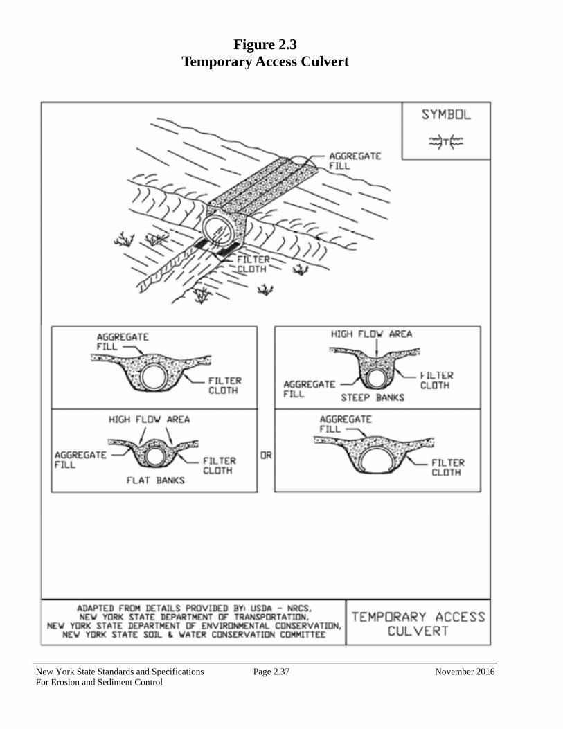
Definition & Scope A temporary pit which is constructed using pipe and stone for pumping excessive water from excavations to a suitable discharge area. Conditions Where Practice Applies Sump pits are constructed when water collects during the excavation phase of construction. This practice is particularly useful in urban areas during excavation for building foundations. It may also be necessary during construction activities that encounter high ground water tables in floodplain locations. Design Criteria The number of sump pits and their locations shall be determined by the contractor/engineer. A design is not required, but construction should conform to the general criteria outlined on Figure 3.3 on page 3.8. A perforated vertical standpipe is placed in the center of the pit and surrounded with a stone screening material to collect filtered water. Water is then pumped from the center of the pipe to a suitable discharge area.
Discharge of turbid water pumped from the standpipe should be to a sediment trap, sediment basin, filter bag or stabilized area, such as a filter strip. If water from the sump pit will be pumped directly to a storm drain system, filter cloth with an equivalent sieve size between 40-80 should be wrapped around the standpipe to ensure clean water discharge. It is recommended that ¼ to ½ inch hardware cloth be wrapped around and secured to the standpipe prior to attaching the filter cloth. This will increase the rate of water seepage into the standpipe.
STANDARD AND SPECIFICATIONS FOR DEWATERING SUMP PIT
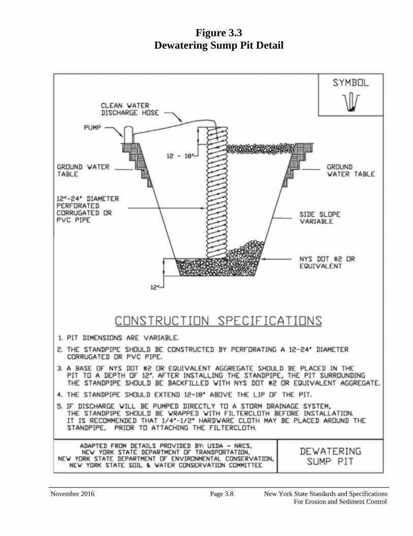
November 2016 Page 3.8 New York State Standards and Specifications For Erosion and Sediment Control
Figure 3.3 Dewatering Sump Pit Detail
November 2016 Page 5.54 New York State Standards and Specifica-tions For Erosion and Sediment Control
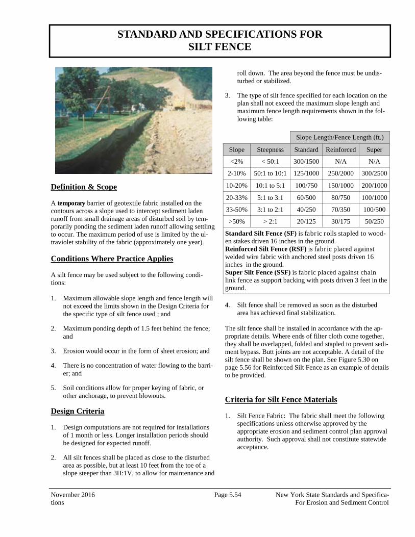
STANDARD AND SPECIFICATIONS FOR SILT FENCE
Definition & Scope A temporary barrier of geotextile fabric installed on the contours across a slope used to intercept sediment laden runoff from small drainage areas of disturbed soil by tem-porarily ponding the sediment laden runoff allowing settling to occur. The maximum period of use is limited by the ul-traviolet stability of the fabric (approximately one year). Conditions Where Practice Applies A silt fence may be used subject to the following condi-tions: 1. Maximum allowable slope length and fence length will
not exceed the limits shown in the Design Criteria for the specific type of silt fence used ; and
2. Maximum ponding depth of 1.5 feet behind the fence; and
3. Erosion would occur in the form of sheet erosion; and
4. There is no concentration of water flowing to the barri-er; and
5. Soil conditions allow for proper keying of fabric, or other anchorage, to prevent blowouts.
Design Criteria 1. Design computations are not required for installations
of 1 month or less. Longer installation periods should be designed for expected runoff.
2. All silt fences shall be placed as close to the disturbed area as possible, but at least 10 feet from the toe of a slope steeper than 3H:1V, to allow for maintenance and
roll down. The area beyond the fence must be undis-turbed or stabilized.
3. The type of silt fence specified for each location on the plan shall not exceed the maximum slope length and maximum fence length requirements shown in the fol-lowing table:
4. Silt fence shall be removed as soon as the disturbed area has achieved final stabilization.
The silt fence shall be installed in accordance with the ap-propriate details. Where ends of filter cloth come together, they shall be overlapped, folded and stapled to prevent sedi-ment bypass. Butt joints are not acceptable. A detail of the silt fence shall be shown on the plan. See Figure 5.30 on page 5.56 for Reinforced Silt Fence as an example of details to be provided. Criteria for Silt Fence Materials 1. Silt Fence Fabric: The fabric shall meet the following
specifications unless otherwise approved by the appropriate erosion and sediment control plan approval authority. Such approval shall not constitute statewide acceptance.
Slope Length/Fence Length (ft.)
Slope Steepness Standard Reinforced Super
<2% < 50:1 300/1500 N/A N/A
2-10% 50:1 to 10:1 125/1000 250/2000 300/2500
10-20% 10:1 to 5:1 100/750 150/1000 200/1000
20-33% 5:1 to 3:1 60/500 80/750 100/1000
33-50% 3:1 to 2:1 40/250 70/350 100/500
>50% > 2:1 20/125 30/175 50/250
Standard Silt Fence (SF) is fabr ic rolls stapled to wood-en stakes driven 16 inches in the ground. Reinforced Silt Fence (RSF) is fabr ic placed against welded wire fabric with anchored steel posts driven 16 inches in the ground. Super Silt Fence (SSF) is fabr ic placed against chain link fence as support backing with posts driven 3 feet in the ground.
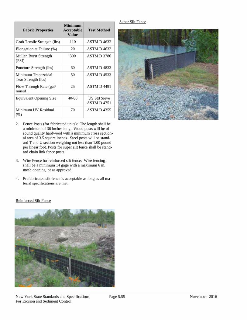
New York State Standards and Specifications Page 5.55 November 2016 For Erosion and Sediment Control
2. Fence Posts (for fabricated units): The length shall be a minimum of 36 inches long. Wood posts will be of sound quality hardwood with a minimum cross section-al area of 3.5 square inches. Steel posts will be stand-ard T and U section weighing not less than 1.00 pound per linear foot. Posts for super silt fence shall be stand-ard chain link fence posts.
3. Wire Fence for reinforced silt fence: Wire fencing shall be a minimum 14 gage with a maximum 6 in. mesh opening, or as approved.
4. Prefabricated silt fence is acceptable as long as all ma-terial specifications are met.
Reinforced Silt Fence
Super Silt Fence
Fabric Properties Minimum Acceptable
Value Test Method
Grab Tensile Strength (lbs) 110 ASTM D 4632
Elongation at Failure (%) 20 ASTM D 4632
Mullen Burst Strength (PSI)
300 ASTM D 3786
Puncture Strength (lbs) 60 ASTM D 4833
Minimum Trapezoidal Tear Strength (lbs)
50 ASTM D 4533
Flow Through Rate (gal/min/sf)
25 ASTM D 4491
Equivalent Opening Size 40-80 US Std Sieve ASTM D 4751
Minimum UV Residual (%)
70 ASTM D 4355
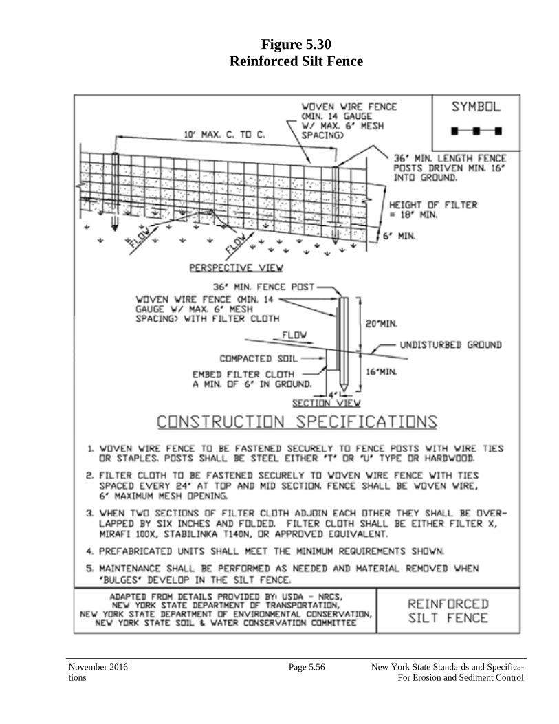
November 2016 Page 5.56 New York State Standards and Specifica-tions For Erosion and Sediment Control
Figure 5.30 Reinforced Silt Fence
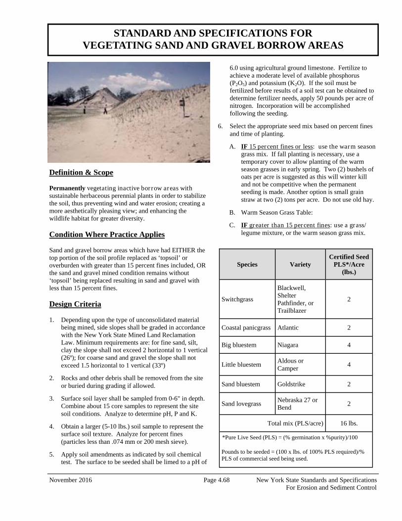
November 2016 Page 4.68 New York State Standards and Specifications For Erosion and Sediment Control
Definition & Scope Permanently vegetating inactive bor row areas with sustainable herbaceous perennial plants in order to stabilize the soil, thus preventing wind and water erosion; creating a more aesthetically pleasing view; and enhancing the wildlife habitat for greater diversity. Condition Where Practice Applies Sand and gravel borrow areas which have had EITHER the top portion of the soil profile replaced as ‘topsoil’ or overburden with greater than 15 percent fines included, OR the sand and gravel mined condition remains without ‘topsoil’ being replaced resulting in sand and gravel with less than 15 percent fines. Design Criteria 1. Depending upon the type of unconsolidated material
being mined, side slopes shall be graded in accordance with the New York State Mined Land Reclamation Law. Minimum requirements are: for fine sand, silt, clay the slope shall not exceed 2 horizontal to 1 vertical (26º); for coarse sand and gravel the slope shall not exceed 1.5 horizontal to 1 vertical (33º)
2. Rocks and other debris shall be removed from the site or buried during grading if allowed.
3. Surface soil layer shall be sampled from 0-6" in depth. Combine about 15 core samples to represent the site soil conditions. Analyze to determine pH, P and K.
4. Obtain a larger (5-10 lbs.) soil sample to represent the surface soil texture. Analyze for percent fines (particles less than .074 mm or 200 mesh sieve).
5. Apply soil amendments as indicated by soil chemical test. The surface to be seeded shall be limed to a pH of
6.0 using agricultural ground limestone. Fertilize to achieve a moderate level of available phosphorus (P2O5) and potassium (K2O). If the soil must be fertilized before results of a soil test can be obtained to determine fertilizer needs, apply 50 pounds per acre of nitrogen. Incorporation will be accomplished following the seeding.
6. Select the appropriate seed mix based on percent fines and time of planting.
A. IF 15 percent fines or less: use the warm season grass mix. If fall planting is necessary, use a temporary cover to allow planting of the warm season grasses in early spring. Two (2) bushels of oats per acre is suggested as this will winter kill and not be competitive when the permanent seeding is made. Another option is small grain straw at two (2) tons per acre. Do not use old hay.
B. Warm Season Grass Table:
C. IF greater than 15 percent fines: use a grass/legume mixture, or the warm season grass mix.
STANDARD AND SPECIFICATIONS FOR VEGETATING SAND AND GRAVEL BORROW AREAS
Species Variety Certified Seed
PLS*/Acre (lbs.)
Switchgrass
Blackwell, Shelter Pathfinder, or Trailblazer
2
Coastal panicgrass Atlantic 2
Big bluestem Niagara 4
Little bluestem Aldous or Camper
4
Sand bluestem Goldstrike 2
Sand lovegrass Nebraska 27 or Bend
2
Total mix (PLS/acre) 16 lbs.
*Pure Live Seed (PLS) = (% germination x %purity)/100 Pounds to be seeded = (100 x lbs. of 100% PLS required)/% PLS of commercial seed being used.
New York State Standards and Specifications Page 4.69 November 2016 For Erosion and Sediment Control
D. Grass/Legume Table:
OR
7. Planting instructions:
A. Planting dates are very critical for warm season grasses. Very early spring (March/April) is best. The success rate decreases notably by the end of May. Fall seedings are not recommended. Grass/legume mixes may be reliably planted from early spring through June 15. Avoid June 16 through August 15. After August 15, seed anytime until ground freezes.
B. A temporary cover of 2 bushels of oats may be seeded between August 15 and September 15 (oats will winter kill). This works well preparing for early spring seedings.
C. Inoculate legume seed immediately prior to actual seeding. Use 4 times the standard agricultural rates.
D. The seed mix must be uniformly broadcast. A hydroseeder works well or spread by hand if necessary. The use of spinner type seeders is
difficult due to the lightweight and fluffy seed characteristics of some species.
E. Incorporate the soil amendments and seed.
i. “Tracking” an area is using a bulldozer having cleats at least 1 inch in depth. Operation of the dozer shall be perpendicular to the contour and such that the entire area is covered by the tracks.
OR
ii. Pulling a cultipacker over the entire site with the tines up or no deeper than 1 inch. This option only works if soil moisture is near field capacity.
8. Mulching is essential for immediate erosion control and
uniform establishment of cool season grasses and legumes on sands and gravels. Use a heavier rate for the grass/legume seedings of 4000 lbs./ac. Use only small grain straw. Mulching of warm season grasses may not be necessary when runoff and sediment delivery is not an issue. If erosion control is necessary for warm season grass sites, mulch with 3000 lbs./ac. of small grain straw (not grass hay). On sites where mulch can be avoided, warm season grasses will respond favorably.
9. Anchor the mulch by using the bulldozer tracking technique. This may be done simultaneously with seed incorporation. Optional anchoring techniques and materials are available in the Mulching Standard.
10. Site protection is necessary to avoid wheel and tire damage.
Species Variety Pure Live Seed Per Acre (lbs.)
Creeping red fes-cue
Common 10
Smooth Brome-grass
Common 2
Perennial ryegrass Pennfine/Linn 5
Red clover* Empire plus Pardee
8**
* legume in seed mixture needs to be inoculated. ** 4 lbs. of each is best. 8 lbs. of either one is good.
Species Variety Pure Live Seed per Acre (lbs.)
Flatpea* Lathco 10.0
Perennial pea* Lancer 2.0
American vetch* Common 10.0
Hard fescue Common 10.0
Total Mix (lbs./acre) 32.0
* legume in seed mixture needs to be inoculated.
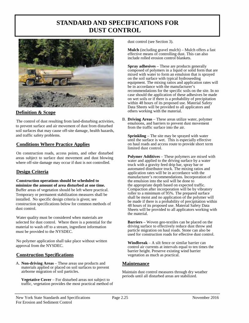
New York State Standards and Specifications Page 2.25 November 2016 For Erosion and Sediment Control
Definition & Scope The control of dust resulting from land-disturbing activities, to prevent surface and air movement of dust from disturbed soil surfaces that may cause off-site damage, health hazards, and traffic safety problems.
Conditions Where Practice Applies
On construction roads, access points, and other disturbed areas subject to surface dust movement and dust blowing where off-site damage may occur if dust is not controlled.
Design Criteria
Construction operations should be scheduled to minimize the amount of area disturbed at one time. Buffer areas of vegetation should be left where practical. Temporary or permanent stabilization measures shall be installed. No specific design criteria is given; see construction specifications below for common methods of dust control.
Water quality must be considered when materials are selected for dust control. Where there is a potential for the material to wash off to a stream, ingredient information must be provided to the NYSDEC. No polymer application shall take place without written approval from the NYSDEC.
Construction Specifications A. Non-driving Areas – These areas use products and
materials applied or placed on soil surfaces to prevent airborne migration of soil particles.
Vegetative Cover – For disturbed areas not subject to traffic, vegetation provides the most practical method of
dust control (see Section 3).
Mulch (including gravel mulch) – Mulch offers a fast effective means of controlling dust. This can also include rolled erosion control blankets. Spray adhesives – These are products generally composed of polymers in a liquid or solid form that are mixed with water to form an emulsion that is sprayed on the soil surface with typical hydroseeding equipment. The mixing ratios and application rates will be in accordance with the manufacturer’s recommendations for the specific soils on the site. In no case should the application of these adhesives be made on wet soils or if there is a probability of precipitation within 48 hours of its proposed use. Material Safety Data Sheets will be provided to all applicators and others working with the material.
B. Driving Areas – These areas utilize water, polymer
emulsions, and barriers to prevent dust movement from the traffic surface into the air.
Sprinkling – The site may be sprayed with water until the surface is wet. This is especially effective on haul roads and access route to provide short term limited dust control. Polymer Additives – These polymers are mixed with water and applied to the driving surface by a water truck with a gravity feed drip bar, spray bar or automated distributor truck. The mixing ratios and application rates will be in accordance with the manufacturer’s recommendations. Incorporation of the emulsion into the soil will be done to the appropriate depth based on expected traffic. Compaction after incorporation will be by vibratory roller to a minimum of 95%. The prepared surface shall be moist and no application of the polymer will be made if there is a probability of precipitation within 48 hours of its proposed use. Material Safety Data Sheets will be provided to all applicators working with the material. Barriers – Woven geo-textiles can be placed on the driving surface to effectively reduce dust throw and particle migration on haul roads. Stone can also be used for construction roads for effective dust control. Windbreak – A silt fence or similar barrier can control air currents at intervals equal to ten times the barrier height. Preserve existing wind barrier vegetation as much as practical.
Maintenance
Maintain dust control measures through dry weather periods until all disturbed areas are stabilized.
STANDARD AND SPECIFICATIONS FOR DUST CONTROL
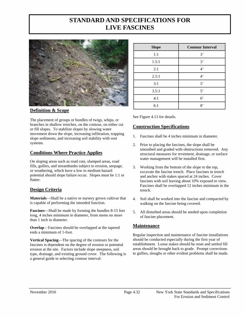
November 2016 Page 4.32 New York State Standards and Specifications For Erosion and Sediment Control
Definition & Scope The placement of groups or bundles of twigs, whips, or branches in shallow trenches, on the contour, on either cut or fill slopes. To stabilize slopes by slowing water movement down the slope, increasing infiltration, trapping slope sediments, and increasing soil stability with root systems. Conditions Where Practice Applies
On sloping areas such as road cuts, slumped areas, road fills, gullies, and streambanks subject to erosion, seepage, or weathering, which have a low to medium hazard potential should slope failure occur. Slopes must be 1:1 or flatter. Design Criteria
Materials—Shall be a native or nursery grown cultivar that is capable of performing the intended function.
Fascines—Shall be made by forming the bundles 8-15 feet long, 4 inches minimum in diameter, from stems no more than 1 inch in diameter.
Overlap—Fascines should be overlapped at the tapered ends a minimum of 1-foot.
Vertical Spacing—The spacing of the contours for the fascines is dependent on the degree of erosion or potential erosion at the site. Factors include slope steepness, soil type, drainage, and existing ground cover. The following is a general guide to selecting contour interval:
See Figure 4.13 for details. Construction Specifications 1. Fascines shall be 4 inches minimum in diameter.
2. Prior to placing the fascines, the slope shall be smoothed and graded with obstructions removed. Any structural measures for revetment, drainage, or surface water management will be installed first.
3. Working from the bottom of the slope to the top, excavate the fascine trench. Place fascines in trench and anchor with stakes spaced at 24 inches. Cover fascines with soil leaving about 10% exposed to view. Fascines shall be overlapped 12 inches minimum in the trench.
4. Soil shall be worked into the fascine and compacted by walking on the fascine being covered.
5. All disturbed areas should be seeded upon completion of fascine placement.
Maintenance Regular inspection and maintenance of fascine installations should be conducted especially during the first year of establishment. Loose stakes should be reset and settled fill areas should be brought back to grade. Prompt corrections to gullies, sloughs or other evident problems shall be made.
STANDARD AND SPECIFICATIONS FOR LIVE FASCINES
Slope Contour Interval
1:1 3’
1.5:1 3’
2:1 4’
2.5:1 4’
3:1 5’
3.5:1 5’
4:1 6’
6:1 8’
New York State Standards and Specifications Page 4.33 November 2016 For Erosion and Sediment Control
Figure 4.13 Live Fascine
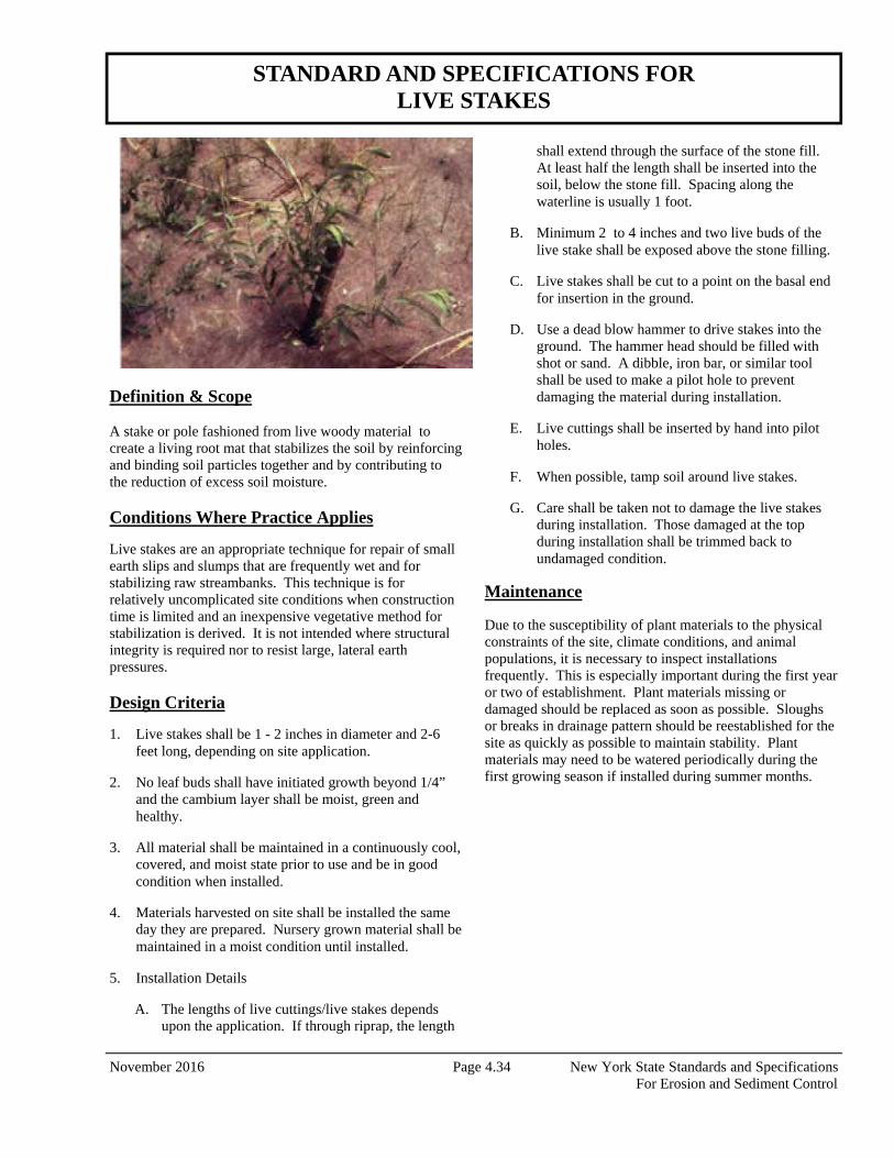
November 2016 Page 4.34 New York State Standards and Specifications For Erosion and Sediment Control
Definition & Scope A stake or pole fashioned from live woody material to create a living root mat that stabilizes the soil by reinforcing and binding soil particles together and by contributing to the reduction of excess soil moisture. Conditions Where Practice Applies
Live stakes are an appropriate technique for repair of small earth slips and slumps that are frequently wet and for stabilizing raw streambanks. This technique is for relatively uncomplicated site conditions when construction time is limited and an inexpensive vegetative method for stabilization is derived. It is not intended where structural integrity is required nor to resist large, lateral earth pressures. Design Criteria
1. Live stakes shall be 1 - 2 inches in diameter and 2-6 feet long, depending on site application.
2. No leaf buds shall have initiated growth beyond 1/4” and the cambium layer shall be moist, green and healthy.
3. All material shall be maintained in a continuously cool, covered, and moist state prior to use and be in good condition when installed.
4. Materials harvested on site shall be installed the same day they are prepared. Nursery grown material shall be maintained in a moist condition until installed.
5. Installation Details
A. The lengths of live cuttings/live stakes depends upon the application. If through riprap, the length
shall extend through the surface of the stone fill. At least half the length shall be inserted into the soil, below the stone fill. Spacing along the waterline is usually 1 foot.
B. Minimum 2 to 4 inches and two live buds of the live stake shall be exposed above the stone filling.
C. Live stakes shall be cut to a point on the basal end for insertion in the ground.
D. Use a dead blow hammer to drive stakes into the ground. The hammer head should be filled with shot or sand. A dibble, iron bar, or similar tool shall be used to make a pilot hole to prevent damaging the material during installation.
E. Live cuttings shall be inserted by hand into pilot holes.
F. When possible, tamp soil around live stakes.
G. Care shall be taken not to damage the live stakes during installation. Those damaged at the top during installation shall be trimmed back to undamaged condition.
Maintenance Due to the susceptibility of plant materials to the physical constraints of the site, climate conditions, and animal populations, it is necessary to inspect installations frequently. This is especially important during the first year or two of establishment. Plant materials missing or damaged should be replaced as soon as possible. Sloughs or breaks in drainage pattern should be reestablished for the site as quickly as possible to maintain stability. Plant materials may need to be watered periodically during the first growing season if installed during summer months.
STANDARD AND SPECIFICATIONS FOR LIVE STAKES
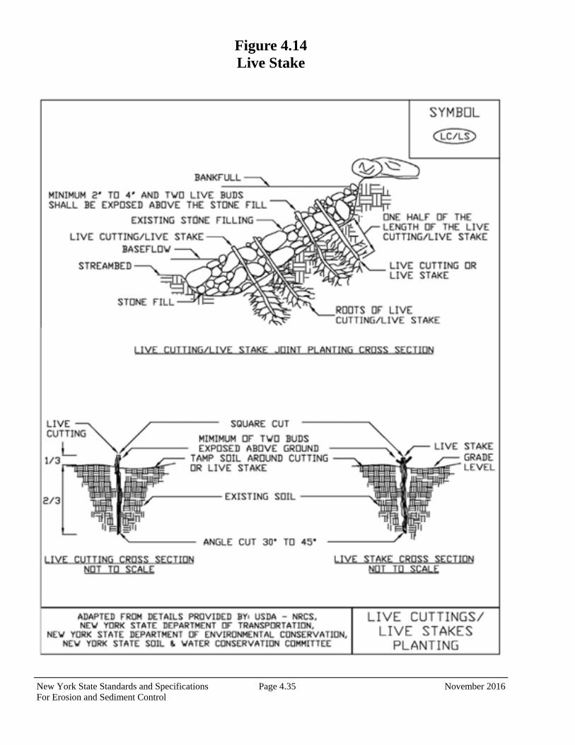
New York State Standards and Specifications Page 4.35 November 2016 For Erosion and Sediment Control
Figure 4.14 Live Stake
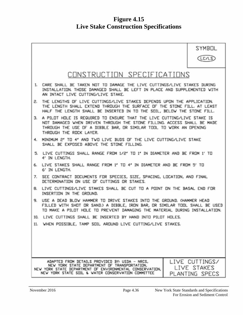
November 2016 Page 4.36 New York State Standards and Specifications For Erosion and Sediment Control
Figure 4.15 Live Stake Construction Specifications
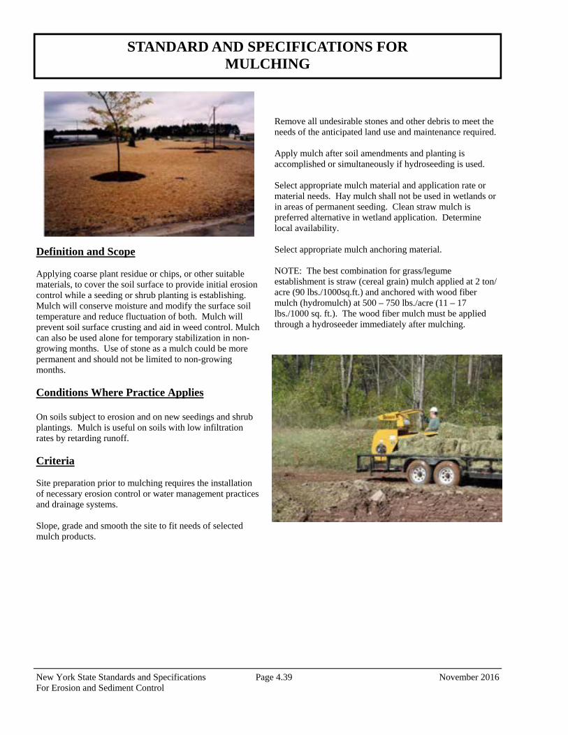
New York State Standards and Specifications Page 4.39 November 2016 For Erosion and Sediment Control
Definition and Scope Applying coarse plant residue or chips, or other suitable materials, to cover the soil surface to provide initial erosion control while a seeding or shrub planting is establishing. Mulch will conserve moisture and modify the surface soil temperature and reduce fluctuation of both. Mulch will prevent soil surface crusting and aid in weed control. Mulch can also be used alone for temporary stabilization in non-growing months. Use of stone as a mulch could be more permanent and should not be limited to non-growing months. Conditions Where Practice Applies On soils subject to erosion and on new seedings and shrub plantings. Mulch is useful on soils with low infiltration rates by retarding runoff. Criteria Site preparation prior to mulching requires the installation of necessary erosion control or water management practices and drainage systems. Slope, grade and smooth the site to fit needs of selected mulch products.
Remove all undesirable stones and other debris to meet the needs of the anticipated land use and maintenance required. Apply mulch after soil amendments and planting is accomplished or simultaneously if hydroseeding is used. Select appropriate mulch material and application rate or material needs. Hay mulch shall not be used in wetlands or in areas of permanent seeding. Clean straw mulch is preferred alternative in wetland application. Determine local availability. Select appropriate mulch anchoring material. NOTE: The best combination for grass/legume establishment is straw (cereal grain) mulch applied at 2 ton/acre (90 lbs./1000sq.ft.) and anchored with wood fiber mulch (hydromulch) at 500 – 750 lbs./acre (11 – 17 lbs./1000 sq. ft.). The wood fiber mulch must be applied through a hydroseeder immediately after mulching.
STANDARD AND SPECIFICATIONS FOR MULCHING
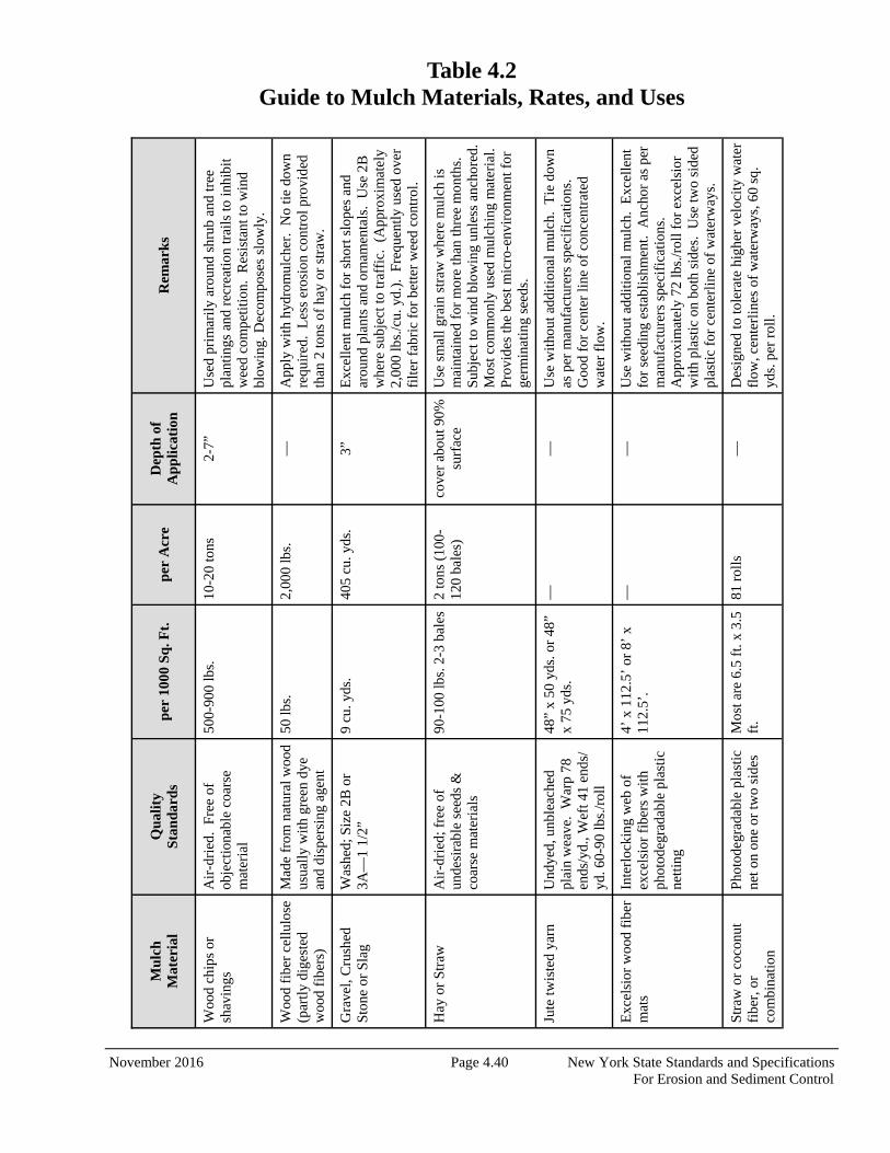
November 2016 Page 4.40 New York State Standards and Specifications For Erosion and Sediment Control
Table 4.2 Guide to Mulch Materials, Rates, and Uses
Mu
lch
Mat
eria
l Q
ual
ity
Sta
nda
rds
per
100
0 S
q. F
t.
per
Acr
e D
epth
of
A
pp
licat
ion
R
emar
ks
Woo
d ch
ips
or
shav
ings
A
ir-d
ried
. F
ree
of
obje
ctio
nabl
e co
arse
m
ater
ial
500-
900
lbs.
10
-20
tons
2-
7”
Use
d pr
imar
ily
arou
nd s
hrub
and
tree
pl
antin
gs a
nd r
ecre
atio
n tr
ails
to in
hibi
t w
eed
com
petit
ion.
Res
ista
nt to
win
d bl
owin
g. D
ecom
pose
s sl
owly
.
Woo
d fi
ber
cellu
lose
(p
artly
dig
este
d w
ood
fibe
rs)
Mad
e fr
om n
atur
al w
ood
usua
lly w
ith g
reen
dye
an
d di
sper
sing
age
nt
50 lb
s.
2,00
0 lb
s.
—
App
ly w
ith h
ydro
mul
cher
. N
o tie
dow
n re
quir
ed.
Les
s er
osio
n co
ntro
l pro
vide
d th
an 2
tons
of
hay
or s
traw
.
Gra
vel,
Cru
shed
S
tone
or
Sla
g
Was
hed;
Siz
e 2B
or
3A—
1 1/
2”
9 cu
. yds
. 40
5 cu
. yds
. 3”
E
xcel
lent
mul
ch f
or s
hort
slo
pes
and
arou
nd p
lant
s an
d or
nam
enta
ls.
Use
2B
w
here
sub
ject
to tr
affi
c. (
App
roxi
mat
ely
2,00
0 lb
s./c
u. y
d.).
Fre
quen
tly u
sed
over
fi
lter
fabr
ic f
or b
ette
r w
eed
cont
rol.
Hay
or
Str
aw
Air
-dri
ed; f
ree
of
unde
sira
ble
seed
s &
co
arse
mat
eria
ls
90-1
00 lb
s. 2
-3 b
ales
2
tons
(10
0-12
0 ba
les)
co
ver
abou
t 90%
su
rfac
e U
se s
mal
l gra
in s
traw
whe
re m
ulch
is
mai
ntai
ned
for
mor
e th
an th
ree
mon
ths.
S
ubje
ct to
win
d bl
owin
g un
less
anc
hore
d.
Mos
t com
mon
ly u
sed
mul
chin
g m
ater
ial.
P
rovi
des
the
best
mic
ro-e
nvir
onm
ent f
or
germ
inat
ing
seed
s.
Jute
twis
ted
yarn
U
ndye
d, u
nble
ache
d pl
ain
wea
ve.
War
p 78
en
ds/y
d., W
eft 4
1 en
ds/
yd. 6
0-90
lbs.
/rol
l
48”
x 50
yds
. or
48”
x 75
yds
. —
—
U
se w
ithou
t add
ition
al m
ulch
. T
ie d
own
as p
er m
anuf
actu
rers
spe
cifi
cati
ons.
G
ood
for
cent
er li
ne o
f co
ncen
trat
ed
wat
er f
low
.
Exc
elsi
or w
ood
fibe
r m
ats
Inte
rloc
king
web
of
exce
lsio
r fi
bers
wit
h ph
otod
egra
dabl
e pl
astic
ne
tting
4’ x
112
.5’
or 8
’ x
112.
5’.
—
—
Use
with
out a
dditi
onal
mul
ch.
Exc
elle
nt
for
seed
ing
esta
blis
hmen
t. A
ncho
r as
per
m
anuf
actu
rers
spe
cifi
cati
ons.
A
ppro
xim
atel
y 72
lbs.
/rol
l for
exc
elsi
or
with
pla
stic
on
both
sid
es.
Use
two
side
d pl
asti
c fo
r ce
nter
line
of
wat
erw
ays.
Stra
w o
r co
conu
t fi
ber,
or
com
bina
tion
Pho
tode
grad
able
pla
stic
ne
t on
one
or tw
o si
des
Mos
t are
6.5
ft.
x 3.
5 ft
. 81
rol
ls
—
Des
igne
d to
tole
rate
hig
her
velo
city
wat
er
flow
, cen
terl
ines
of
wat
erw
ays,
60
sq.
yds.
per
rol
l.
New York State Standards and Specifications Page 4.41 November 2016 For Erosion and Sediment Control
Table 4.3 Mulch Anchoring Guide
Anchoring Method or Material
Kind of Mulch to be Anchored
How to Apply
1. Peg and Twine Hay or straw
After mulching, divide areas into blocks approximately 1 sq. yd. in size. Drive 4-6 pegs per block to within 2” to 3” of soil surface. Secure mulch to surface by stretching twine between pegs in criss-cross pattern on each block. Secure twine around each peg with 2 or more tight turns. Drive pegs flush with soil. Driving stakes into ground tightens the twine.
2. Mulch netting Hay or straw
Staple the light-weight paper, jute, wood fiber, or plastic nettings to soil surface according to manufacturer’s recommendations. Should be biodegradable. Most products are not suitable for foot traffic.
3. Wood cellulose fiber Hay or straw Apply with hydroseeder immediately after mulching. Use 500 lbs. wood fiber per acre. Some products contain an adhesive material (“tackifier”), possibly advantageous.
4. Mulch anchoring tool Hay or straw Apply mulch and pull a mulch anchoring tool (blunt, straight discs) over mulch as near to the contour as possible. Mulch material should be “tucked” into soil surface about 3”.
5. Tackifier Hay or straw
Mix and apply polymeric and gum tackifiers according to manufacturer’s instructions. Avoid application during rain. A 24-hour curing period and a soil temperature higher than 450 Fahrenheit are required.
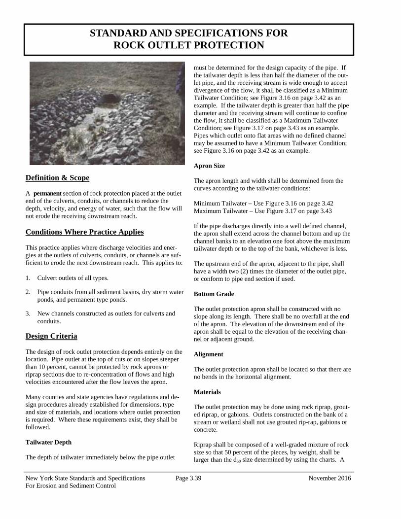
New York State Standards and Specifications Page 3.39 November 2016 For Erosion and Sediment Control
STANDARD AND SPECIFICATIONS FOR ROCK OUTLET PROTECTION
Definition & Scope A permanent section of rock protection placed at the outlet end of the culverts, conduits, or channels to reduce the depth, velocity, and energy of water, such that the flow will not erode the receiving downstream reach. Conditions Where Practice Applies This practice applies where discharge velocities and ener-gies at the outlets of culverts, conduits, or channels are suf-ficient to erode the next downstream reach. This applies to: 1. Culvert outlets of all types.
2. Pipe conduits from all sediment basins, dry storm water ponds, and permanent type ponds.
3. New channels constructed as outlets for culverts and conduits.
Design Criteria
The design of rock outlet protection depends entirely on the location. Pipe outlet at the top of cuts or on slopes steeper than 10 percent, cannot be protected by rock aprons or riprap sections due to re-concentration of flows and high velocities encountered after the flow leaves the apron. Many counties and state agencies have regulations and de-sign procedures already established for dimensions, type and size of materials, and locations where outlet protection is required. Where these requirements exist, they shall be followed. Tailwater Depth The depth of tailwater immediately below the pipe outlet
must be determined for the design capacity of the pipe. If the tailwater depth is less than half the diameter of the out-let pipe, and the receiving stream is wide enough to accept divergence of the flow, it shall be classified as a Minimum Tailwater Condition; see Figure 3.16 on page 3.42 as an example. If the tailwater depth is greater than half the pipe diameter and the receiving stream will continue to confine the flow, it shall be classified as a Maximum Tailwater Condition; see Figure 3.17 on page 3.43 as an example. Pipes which outlet onto flat areas with no defined channel may be assumed to have a Minimum Tailwater Condition; see Figure 3.16 on page 3.42 as an example.
Apron Size The apron length and width shall be determined from the curves according to the tailwater conditions: Minimum Tailwater – Use Figure 3.16 on page 3.42 Maximum Tailwater – Use Figure 3.17 on page 3.43 If the pipe discharges directly into a well defined channel, the apron shall extend across the channel bottom and up the channel banks to an elevation one foot above the maximum tailwater depth or to the top of the bank, whichever is less. The upstream end of the apron, adjacent to the pipe, shall have a width two (2) times the diameter of the outlet pipe, or conform to pipe end section if used. Bottom Grade The outlet protection apron shall be constructed with no slope along its length. There shall be no overfall at the end of the apron. The elevation of the downstream end of the apron shall be equal to the elevation of the receiving chan-nel or adjacent ground. Alignment The outlet protection apron shall be located so that there are no bends in the horizontal alignment. Materials The outlet protection may be done using rock riprap, grout-ed riprap, or gabions. Outlets constructed on the bank of a stream or wetland shall not use grouted rip-rap, gabions or concrete. Riprap shall be composed of a well-graded mixture of rock size so that 50 percent of the pieces, by weight, shall be larger than the d50 size determined by using the charts. A
New York State Standards and Specifications Page 3.40 November 2016 For Erosion and Sediment Control
well-graded mixture, as used herein, is defined as a mixture composed primarily of larger rock sizes, but with a suffi-cient mixture of other sizes to fill the smaller voids between the rocks. The diameter of the largest rock size in such a mixture shall be 1.5 times the d50 size. Thickness
The minimum thickness of the riprap layer shall be 1.5 times the maximum rock diameter for d50 of 15 inches or less; and 1.2 times the maximum rock size for d50 greater than 15 inches. The following chart lists some examples: Rock Quality Rock for riprap shall consist of field rock or rough unhewn quarry rock. The rock shall be hard and angular and of a quality that will not disintegrate on exposure to water or weathering. The specific gravity of the individual rocks shall be at least 2.5. Filter A filter is a layer of material placed between the riprap and the underlying soil surface to prevent soil movement into and through the riprap. Riprap shall have a filter placed under it in all cases. A filter can be of two general forms: a gravel layer or a plastic filter cloth. The plastic filter cloth can be woven or non-woven monofilament yarns, and shall meet these base requirements: thickness 20-60 mils, grab strength 90-120 lbs; and shall conform to ASTM D-1777 and ASTM D-1682. Gravel filter blanket, when used, shall be designed by com-paring particle sizes of the overlying material and the base material. Design criteria are available in Standard and Specification for Anchored Slope and Channel Stabilization on page 4.7.
Gabions Gabions shall be made of hexagonal triple twist mesh with heavily galvanized steel wire. The maximum linear dimen-sion of the mesh opening shall not exceed 4 ½ inches and the area of the mesh opening shall not exceed 10 square inches. Gabions shall be fabricated in such a manner that the sides, ends, and lid can be assembled at the construction site into a rectangular basket of the specified sizes. Gabions shall be of single unit construction and shall be installed according to manufacturer’s recommendations. The area on which the gabion is to be installed shall be graded as shown on the drawings. Foundation conditions shall be the same as for placing rock riprap, and filter cloth shall be placed under all gabions. Where necessary, key, or tie, the structure into the bank to prevent undermining of the main gabion structure. Maintenance Once a riprap outlet has been installed, the maintenance needs are very low. It should be inspected after high flows for evidence of scour beneath the riprap or for dislodged rocks. Repairs should be made immediately. Design Procedure 1. Investigate the downstream channel to assure that
nonerosive velocities can be maintained.
2. Determine the tailwater condition at the outlet to estab-lish which curve to use.
3. Use the appropriate chart with the design discharge to determine the riprap size and apron length required. It is noted that references to pipe diameters in the charts are based on full flow. For other than full pipe flow, the parameters of depth of flow and velocity must be used to adjust the design discharges.
4. Calculate apron width at the downstream end if a flare section is to be employed.
Design Examples are demonstrated in Appendix B. Construction Specifications 1. The subgrade for the filter, riprap, or gabion shall be
prepared to the required lines and grades. Any fill re-quired in the subgrade shall be compacted to a density of approximately that of the surrounding undisturbed material.
2. The rock or gravel shall conform to the specified grad-
D50 (inches)
dmax (inches)
Minimum Blanket Thick-
ness (inches)
4 6 9
6 9 14
9 14 20
12 18 27
15 22 32
18 27 32
21 32 38
24 36 43
New York State Standards and Specifications Page 3.41 November 2016 For Erosion and Sediment Control
ing limits when installed respectively in the riprap or filter.
3. Filter cloth shall be protected from punching, cutting, or tearing. Any damage other than an occasional small hole shall be repaired by placing another piece of cloth over the damaged part or by completely replacing the cloth. All overlaps, whether for repairs or for joining two pieces of cloth shall be a minimum of one foot.
4. Rock for the riprap or gabion outlets may be placed by equipment. Both shall each be constructed to the full course thickness in one operation and in such a manner as to avoid displacement of underlying materials. The rock for riprap or gabion outlets shall be delivered and placed in a manner that will ensure that it is reasonably homogenous with the smaller rocks and spalls filling the voids between the larger rocks. Riprap shall be placed in a manner to prevent damage to the filter blan-ket or filter cloth. Hand placement will be required to the extent necessary to prevent damage to the perma-nent works.
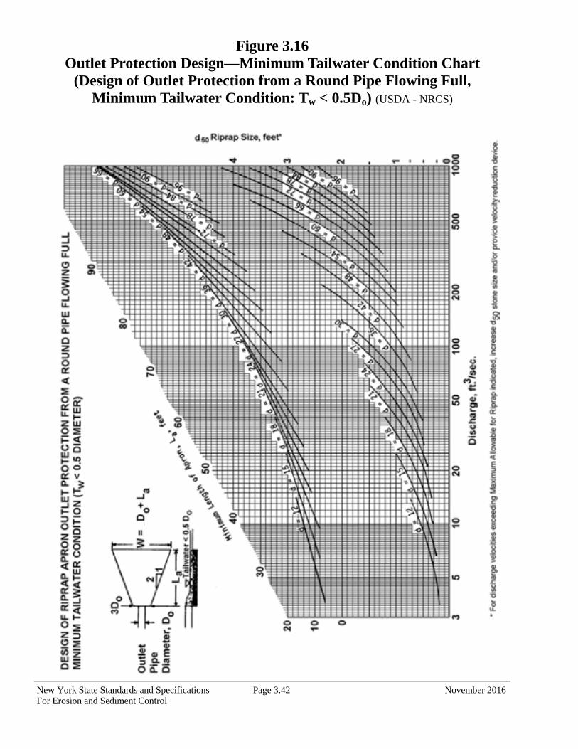
New York State Standards and Specifications Page 3.42 November 2016 For Erosion and Sediment Control
Figure 3.16 Outlet Protection Design—Minimum Tailwater Condition Chart
(Design of Outlet Protection from a Round Pipe Flowing Full, Minimum Tailwater Condition: Tw < 0.5Do) (USDA - NRCS)
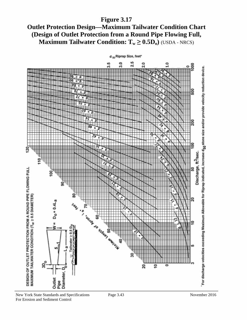
New York State Standards and Specifications Page 3.43 November 2016 For Erosion and Sediment Control
Figure 3.17 Outlet Protection Design—Maximum Tailwater Condition Chart
(Design of Outlet Protection from a Round Pipe Flowing Full, Maximum Tailwater Condition: Tw ≥ 0.5Do) (USDA - NRCS)
2.0
1.0
0
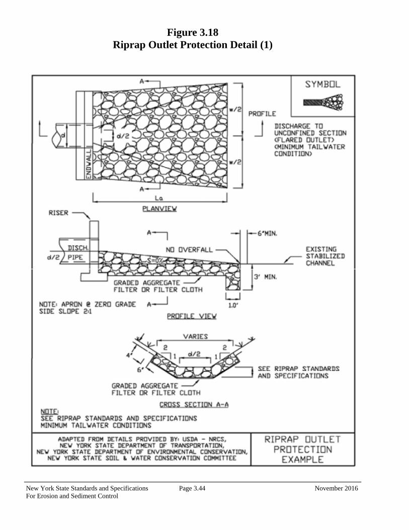
New York State Standards and Specifications Page 3.44 November 2016 For Erosion and Sediment Control
Figure 3.18 Riprap Outlet Protection Detail (1)
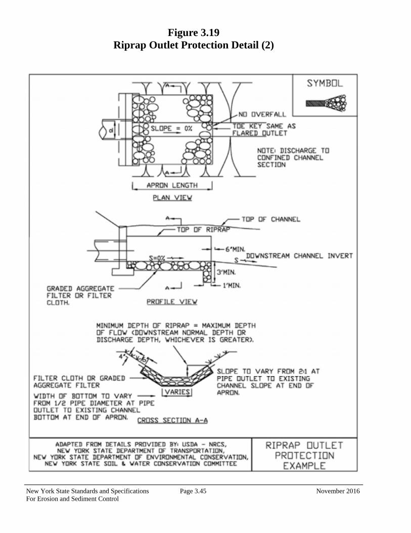
New York State Standards and Specifications Page 3.45 November 2016 For Erosion and Sediment Control
Figure 3.19 Riprap Outlet Protection Detail (2)
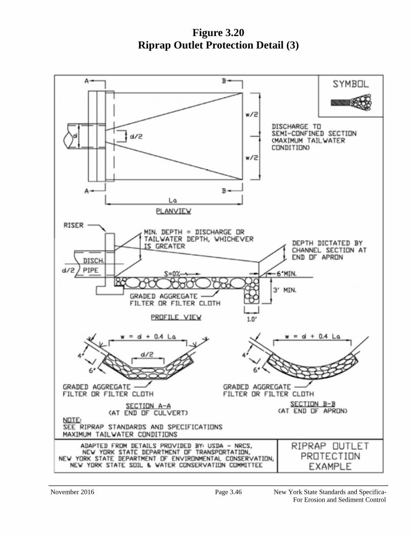
November 2016 Page 3.46 New York State Standards and Specifica- For Erosion and Sediment Control
Figure 3.20 Riprap Outlet Protection Detail (3)
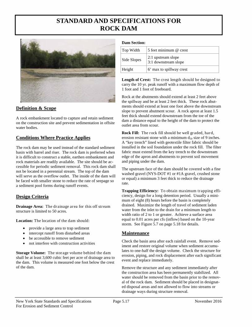
New York State Standards and Specifications Page 5.17 November 2016 For Erosion and Sediment Control
STANDARD AND SPECIFICATIONS FOR ROCK DAM
Definition & Scope A rock embankment located to capture and retain sediment on the construction site and prevent sedimentation in offsite water bodies. Conditions Where Practice Applies The rock dam may be used instead of the standard sediment basin with barrel and riser. The rock dam is preferred when it is difficult to construct a stable, earthen embankment and rock materials are readily available. The site should be ac-cessible for periodic sediment removal. This rock dam shall not be located in a perennial stream. The top of the dam will serve as the overflow outlet. The inside of the dam will be faced with smaller stone to reduce the rate of seepage so a sediment pool forms during runoff events. Design Criteria Drainage Area: The drainage area for this off stream structure is limited to 50 acres. Location: The location of the dam should:
provide a large area to trap sediment intercept runoff from disturbed areas be accessible to remove sediment not interfere with construction activities
Storage Volume: The storage volume behind the dam shall be at least 3,600 cubic feet per acre of drainage area to the dam. This volume is measured one foot below the crest of the dam.
Dam Section:
Length of Crest: The crest length should be designed to carry the 10 yr. peak runoff with a maximum flow depth of 1 foot and 1 foot of freeboard.
Rock at the abutments should extend at least 2 feet above the spillway and be at least 2 feet thick. These rock abut-ments should extend at least one foot above the downstream slope to prevent abutment scour. A rock apron at least 1.5 feet thick should extend downstream from the toe of the dam a distance equal to the height of the dam to protect the outlet area from scour.
Rock Fill: The rock fill should be well graded, hard, erosion resistant stone with a minimum d50 size of 9 inches. A “key trench” lined with geotextile filter fabric should be installed in the soil foundation under the rock fill. The filter fabric must extend from the key trench to the downstream edge of the apron and abutments to prevent soil movement and piping under the dam.
The upstream face of the dam should be covered with a fine washed gravel (NYS-DOT #1 or #1A gravel, crushed stone or equal) a minimum 3 feet thick to reduce the drainage rate.
Trapping Efficiency: To obtain maximum trapping effi-ciency, design for a long detention period. Usually a mini-mum of eight (8) hours before the basin is completely drained. Maximize the length of travel of sediment laden water from the inlet to the drain for a minimum length to width ratio of 2 to 1 or greater. Achieve a surface area equal to 0.01 acres per cfs (inflow) based on the 10-year storm. See Figure 5.7 on page 5.18 for details.
Maintenance
Check the basin area after each rainfall event. Remove sed-iment and restore original volume when sediment accumu-lates to one-half the design volume. Check the structure for erosion, piping, and rock displacement after each significant event and replace immediately.
Remove the structure and any sediment immediately after the construction area has been permanently stabilized. All water should be removed from the basin prior to the remov-al of the rock dam. Sediment should be placed in designat-ed disposal areas and not allowed to flow into streams or drainage ways during structure removal.
Top Width 5 feet minimum @ crest
Side Slopes 2:1 upstream slope 3:1 downstream slope
Height 6’ max to spillway crest
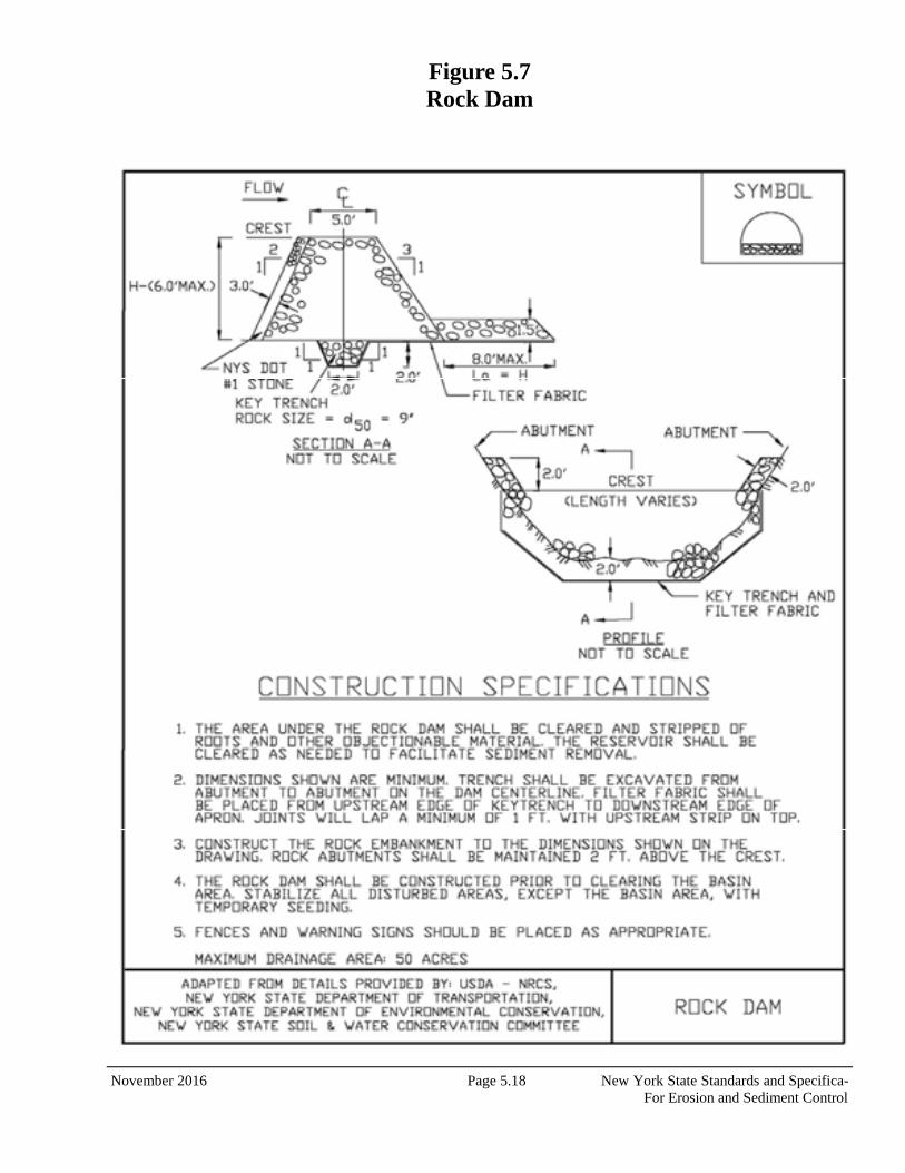
November 2016 Page 5.18 New York State Standards and Specifica- For Erosion and Sediment Control
Figure 5.7 Rock Dam
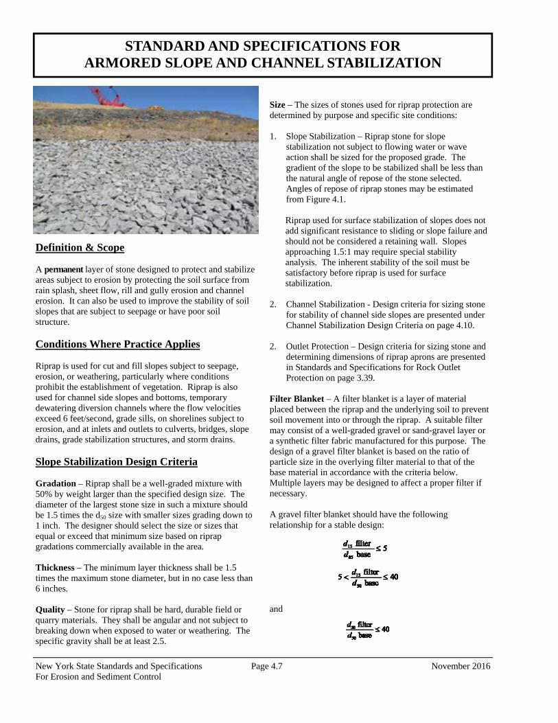
New York State Standards and Specifications Page 4.7 November 2016 For Erosion and Sediment Control
Definition & Scope A permanent layer of stone designed to protect and stabilize areas subject to erosion by protecting the soil surface from rain splash, sheet flow, rill and gully erosion and channel erosion. It can also be used to improve the stability of soil slopes that are subject to seepage or have poor soil structure. Conditions Where Practice Applies Riprap is used for cut and fill slopes subject to seepage, erosion, or weathering, particularly where conditions prohibit the establishment of vegetation. Riprap is also used for channel side slopes and bottoms, temporary dewatering diversion channels where the flow velocities exceed 6 feet/second, grade sills, on shorelines subject to erosion, and at inlets and outlets to culverts, bridges, slope drains, grade stabilization structures, and storm drains. Slope Stabilization Design Criteria Gradation – Riprap shall be a well-graded mixture with 50% by weight larger than the specified design size. The diameter of the largest stone size in such a mixture should be 1.5 times the d50 size with smaller sizes grading down to 1 inch. The designer should select the size or sizes that equal or exceed that minimum size based on riprap gradations commercially available in the area. Thickness – The minimum layer thickness shall be 1.5 times the maximum stone diameter, but in no case less than 6 inches. Quality – Stone for riprap shall be hard, durable field or quarry materials. They shall be angular and not subject to breaking down when exposed to water or weathering. The specific gravity shall be at least 2.5.
Size – The sizes of stones used for riprap protection are determined by purpose and specific site conditions: 1. Slope Stabilization – Riprap stone for slope
stabilization not subject to flowing water or wave action shall be sized for the proposed grade. The gradient of the slope to be stabilized shall be less than the natural angle of repose of the stone selected. Angles of repose of riprap stones may be estimated from Figure 4.1.
Riprap used for surface stabilization of slopes does not add significant resistance to sliding or slope failure and should not be considered a retaining wall. Slopes approaching 1.5:1 may require special stability analysis. The inherent stability of the soil must be satisfactory before riprap is used for surface stabilization.
2. Channel Stabilization - Design criteria for sizing stone for stability of channel side slopes are presented under Channel Stabilization Design Criteria on page 4.10.
2. Outlet Protection – Design criteria for sizing stone and
determining dimensions of riprap aprons are presented in Standards and Specifications for Rock Outlet Protection on page 3.39.
Filter Blanket – A filter blanket is a layer of material placed between the riprap and the underlying soil to prevent soil movement into or through the riprap. A suitable filter may consist of a well-graded gravel or sand-gravel layer or a synthetic filter fabric manufactured for this purpose. The design of a gravel filter blanket is based on the ratio of particle size in the overlying filter material to that of the base material in accordance with the criteria below. Multiple layers may be designed to affect a proper filter if necessary. A gravel filter blanket should have the following relationship for a stable design: and
STANDARD AND SPECIFICATIONS FOR ARMORED SLOPE AND CHANNEL STABILIZATION
November 2016 Page 4.8 New York State Standards and Specifications For Erosion and Sediment Control
Filter refers to the overlying material while base refers to the underlying material. These relationships must hold be-tween the base and filter and the filter and riprap to prevent migration of material. In some cases, more than one filter may be needed. Each filter layer should be a minimum of 6 inches thick, unless an acceptable filter fabric is used. A synthetic filter fabric may be used with or in place of gravel filters. The following particle size relationships should exist: 1. Filter fabric covering a base containing 50% or less by
weight of fine particles (#200 sieve size): A.
B. total open area of filter fabric should not exceed 36%
2. Filter fabric covering other soils:
A. EOS is no larger than 0.21 mm (#70 sieve size)
B. total open area of filter fabric should not exceed 10%
*EOS – Equivalent opening size compared to a U.S. stand-ard sieve size. No filter fabric should have less than 4% open area or an EOS less than U.S. Standard Sieve #100 (0.15 mm). The permeability of the fabric must be greater than that of the soil. The fabric may be made of woven or nonwoven mon-ofilament yarns and should meet the following minimum requirements: Thickness 20-60 mils grab strength 90-120 lbs. conform to ASTM D-1682 or ASTM D-177 Filter blankets should always be provided where seepage is significant or where flow velocity and duration of flow or turbulence may cause underlying soil particles to move though the riprap. Construction Specifications Subgrade Preparation – Prepare the subgrade for riprap and filter to the required lines and grades shown on the plans. Compact any fill required in the subgrade to a densi-ty approximating that of the undisturbed material or overfill depressions with riprap. Remove brush, trees, stumps, and other objectionable material. Cut the subgrade sufficiently deep so that the finished grade of the riprap will be at the
elevation of the surrounding area. Channels shall be exca-vated sufficiently to allow placement of the riprap in a man-ner such that the finished inside dimensions and grade of the riprap meet design specifications.
Sand and gravel filter blanket – Place the filter blanket immediately after the ground foundation is prepared. For gravel, spread filter stone in a uniform layer to the specified depth. Where more than one layer of filter material is used, spread the layers with minimal mixing.
Synthetic filter fabric – Place the cloth directly on the pre-pared foundation. Overlap the edges by at least 2 feet, and space the anchor pins every 3 feet along the overlap. Bury the upper and lower ends of the cloth a minimum of 12 inches below ground. Take precautions not to damage the cloth by dropping the riprap. If damage occurs, remove the riprap and repair the sheet by adding another layer of filter fabric with a minimum overlap of 12 inches around the damaged area. Where large stones are to be placed, a 4-inch layer of fine sand or gravel is recommended to protect the filter cloth. Filter fabric is not recommended as a filter on slopes steeper than 2 horizontal to 1 vertical.
Stone placement – Placement of the riprap shall follow immediately after placement of the filter. Place riprap so that it forms dense, well-graded mass of stone with a mini-mum of voids. The desired distribution of stones through-out the mass may be obtained by selective loading at the quarry and controlled dumping during final placement. Place riprap to its full thickness in one operation. Do not place riprap by dumping through chutes or other methods that cause segregation of stone sizes. Be careful not to dis-lodge the underlying base or filter when placing the stones.
The toe of the riprap shall be keyed into a stable foundation at its base as shown in Figure 4.2 - Typical Riprap Slope Protection Detail. The toe should be excavated to a depth of 2.0 feet. The design thickness of the riprap shall extend a minimum of 3 feet horizontally from the slope. The fin-ished slope should be free of pockets of small stone or clus-ters of large stones. Hand placing may be necessary to achieve proper distribution of stone sizes to produce a rela-tively smooth, uniform surface. The finished grade of the riprap should blend with the surrounding area.
Maintenance Riprap shall be inspected periodically for scour or dislodged stones. Control weed and brush growth as needed.
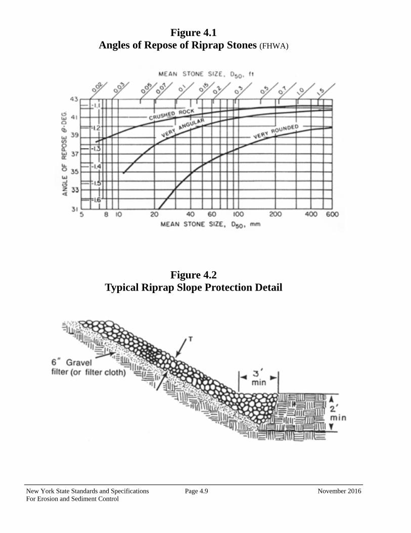
New York State Standards and Specifications Page 4.9 November 2016 For Erosion and Sediment Control
Figure 4.1 Angles of Repose of Riprap Stones (FHWA)
Figure 4.2 Typical Riprap Slope Protection Detail
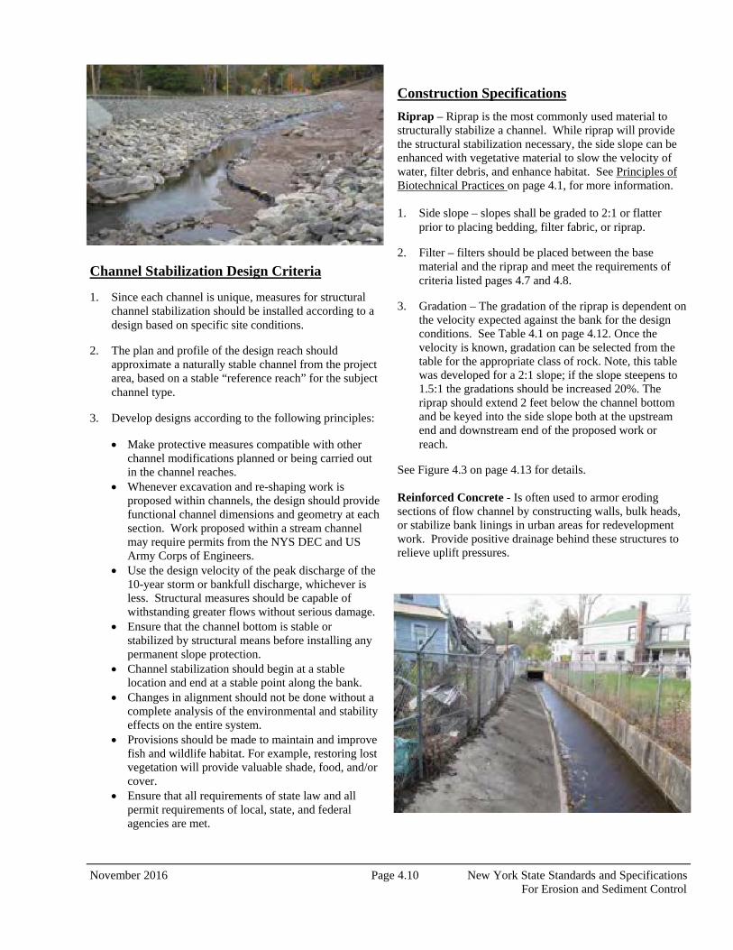
November 2016 Page 4.10 New York State Standards and Specifications For Erosion and Sediment Control
Channel Stabilization Design Criteria
1. Since each channel is unique, measures for structural channel stabilization should be installed according to a design based on specific site conditions.
2. The plan and profile of the design reach should approximate a naturally stable channel from the project area, based on a stable “reference reach” for the subject channel type.
3. Develop designs according to the following principles:
Make protective measures compatible with other channel modifications planned or being carried out in the channel reaches.
Whenever excavation and re-shaping work is proposed within channels, the design should provide functional channel dimensions and geometry at each section. Work proposed within a stream channel may require permits from the NYS DEC and US Army Corps of Engineers.
Use the design velocity of the peak discharge of the 10-year storm or bankfull discharge, whichever is less. Structural measures should be capable of withstanding greater flows without serious damage.
Ensure that the channel bottom is stable or stabilized by structural means before installing any permanent slope protection.
Channel stabilization should begin at a stable location and end at a stable point along the bank.
Changes in alignment should not be done without a complete analysis of the environmental and stability effects on the entire system.
Provisions should be made to maintain and improve fish and wildlife habitat. For example, restoring lost vegetation will provide valuable shade, food, and/or cover.
Ensure that all requirements of state law and all permit requirements of local, state, and federal agencies are met.
Construction Specifications
Riprap – Riprap is the most commonly used material to structurally stabilize a channel. While riprap will provide the structural stabilization necessary, the side slope can be enhanced with vegetative material to slow the velocity of water, filter debris, and enhance habitat. See Principles of Biotechnical Practices on page 4.1, for more information.
1. Side slope – slopes shall be graded to 2:1 or flatter
prior to placing bedding, filter fabric, or riprap.
2. Filter – filters should be placed between the base material and the riprap and meet the requirements of criteria listed pages 4.7 and 4.8.
3. Gradation – The gradation of the riprap is dependent on the velocity expected against the bank for the design conditions. See Table 4.1 on page 4.12. Once the velocity is known, gradation can be selected from the table for the appropriate class of rock. Note, this table was developed for a 2:1 slope; if the slope steepens to 1.5:1 the gradations should be increased 20%. The riprap should extend 2 feet below the channel bottom and be keyed into the side slope both at the upstream end and downstream end of the proposed work or reach.
See Figure 4.3 on page 4.13 for details. Reinforced Concrete - Is often used to armor eroding sections of flow channel by constructing walls, bulk heads, or stabilize bank linings in urban areas for redevelopment work. Provide positive drainage behind these structures to relieve uplift pressures.

New York State Standards and Specifications Page 4.11 November 2016 For Erosion and Sediment Control
Grid Pavers – Modular concrete units with or without void areas can be used to stabilize flow channel. Units with void areas can allow the establishment of vegetation. These structures may be obtained in a variety of shapes (Figure 4.4) or they may be formed and poured in place. Maintain design and installation in accordance with manufacturer’s instructions.
Revetment – Structural support or armoring to protect an embankment from erosion. Riprap and gabions are commonly used. Also used is a hollow fabric mattress with cells that receive a concrete mixture. Any revetment should be installed to a depth below the anticipated channel degradation and into the channel bed as necessary to provide stability.
Modular Pre-Cast Units – Interlocking modular precast units of different sizes, shapes, heights, and depths, have been developed for a wide variety of applications. They provide vertical support in tight areas as well as durability. Many types are available with textured surfaces. They also act as gravity retaining walls. They should be designed and installed in accordance with the manufacturer’s recommendations (Figure 4.4). All areas disturbed by construction should be stabilized as soon as the structural measures are complete.
Maintenance
Check stabilized flow channel sections after every high-water event, and make any needed repairs immediately to prevent any further damage or unraveling of the existing work.
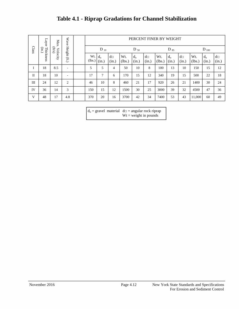
November 2016 Page 4.12 New York State Standards and Specifications For Erosion and Sediment Control
Table 4.1 - Riprap Gradations for Channel Stabilization
Class
Layer T
hickness (in.)
Max. V
elocity (ft/s)
Wave H
eight (ft.)
PERCENT FINER BY WEIGHT
Wt. (lbs.)
do (in.)
d□ (in.)
Wt. (lbs.)
do (in.)
d□ (in.)
Wt. (lbs.)
do (in.)
d□ (in.)
Wt. (lbs.)
do (in.)
d□ (in.)
I 18 8.5 - 5 5 4 50 10 8 100 13 10 150 15 12
II 18 10 - 17 7 6 170 15 12 340 19 15 500 22 18
III 24 12 2 46 10 8 460 21 17 920 26 21 1400 30 24
IV 36 14 3 150 15 12 1500 30 25 3000 39 32 4500 47 36
V 48 17 4.8 370 20 16 3700 42 34 7400 53 43 11,000 60 49
D 10 D 50 D 85 D 100
do = gravel material d□ = angular rock riprap Wt = weight in pounds

New York State Standards and Specifications Page 4.13 November 2016 For Erosion and Sediment Control
Figure 4.3 Riprap Channel Stabilization
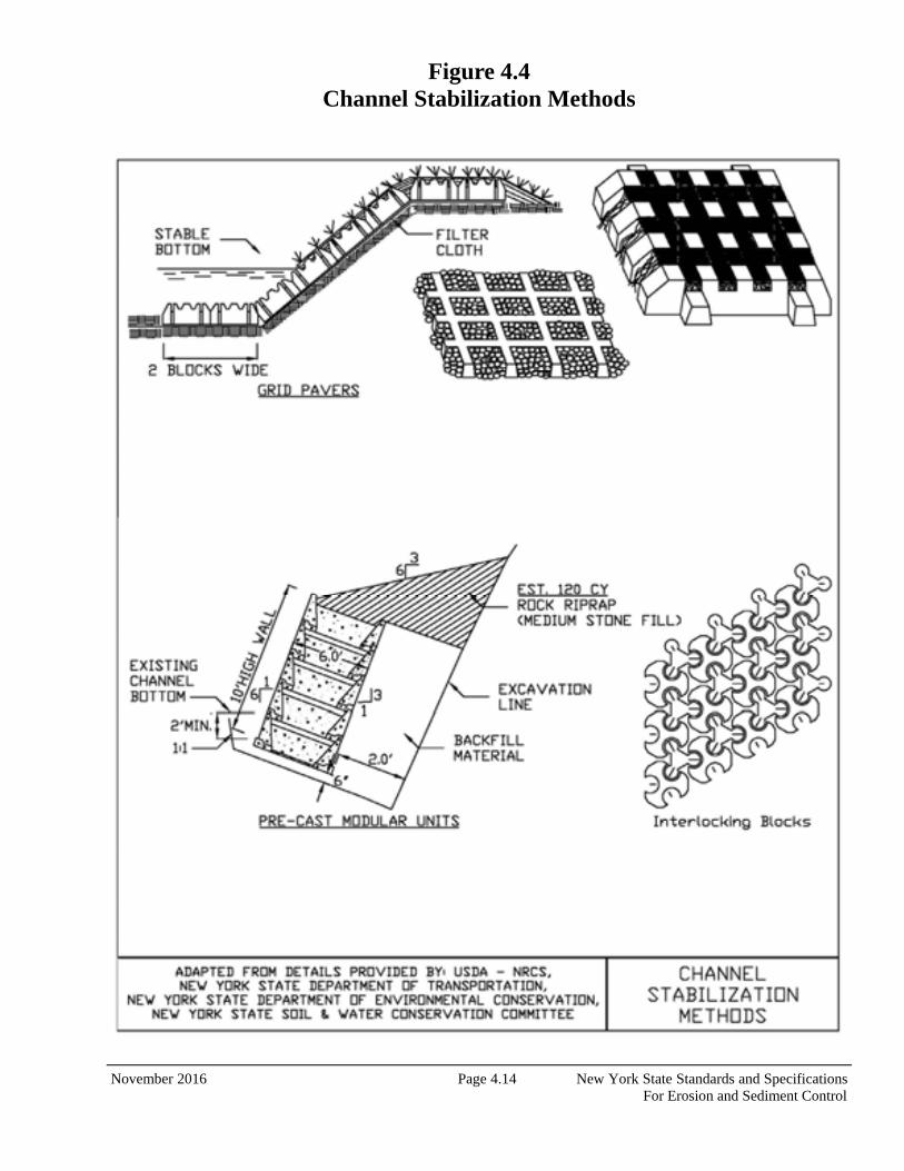
November 2016 Page 4.14 New York State Standards and Specifications For Erosion and Sediment Control
Figure 4.4 Channel Stabilization Methods
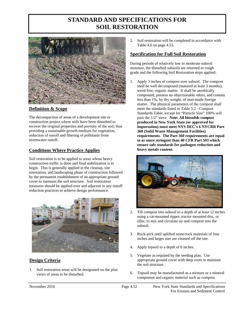
November 2016 Page 4.52 New York State Standards and Specifications For Erosion and Sediment Control
Definition & Scope
The decompaction of areas of a development site or construction project where soils have been disturbed to recover the original properties and porosity of the soil; thus providing a sustainable growth medium for vegetation, reduction of runoff and filtering of pollutants from stormwater runoff. Conditions Where Practice Applies
Soil restoration is to be applied to areas whose heavy construction traffic is done and final stabilization is to begin. This is generally applied in the cleanup, site restoration, and landscaping phase of construction followed by the permanent establishment of an appropriate ground cover to maintain the soil structure. Soil restoration measures should be applied over and adjacent to any runoff reduction practices to achieve design performance.
2. Soil restoration will be completed in accordance with Table 4.6 on page 4.53.
Specification for Full Soil Restoration During periods of relatively low to moderate subsoil moisture, the disturbed subsoils are returned to rough grade and the following Soil Restoration steps applied: 1. Apply 3 inches of compost over subsoil. The compost
shall be well decomposed (matured at least 3 months), weed-free, organic matter. It shall be aerobically composted, possess no objectionable odors, and contain less than 1%, by dry weight, of man-made foreign matter. The physical parameters of the compost shall meet the standards listed in Table 5.2 - Compost Standards Table, except for “Particle Size” 100% will pass the 1/2” sieve. Note: All biosolids compost produced in New York State (or approved for importation) must meet NYS DEC’s 6 NYCRR Part 360 (Solid Waste Management Facilities) requirements. The Part 360 requirements are equal to or more stringent than 40 CFR Part 503 which ensure safe standards for pathogen reduction and heavy metals content.
STANDARD AND SPECIFICATIONS FOR SOIL RESTORATION
Design Criteria 1. Soil restoration areas will be designated on the plan
views of areas to be disturbed.
2. Till compost into subsoil to a depth of at least 12 inches using a cat-mounted ripper, tractor mounted disc, or tiller, to mix and circulate air and compost into the subsoil.
3. Rock-pick until uplifted stone/rock materials of four inches and larger size are cleaned off the site.
4. Apply topsoil to a depth of 6 inches.
5. Vegetate as required by the seeding plan. Use appropriate ground cover with deep roots to maintain the soil structure.
6. Topsoil may be manufactured as a mixture or a mineral component and organic material such as compost.
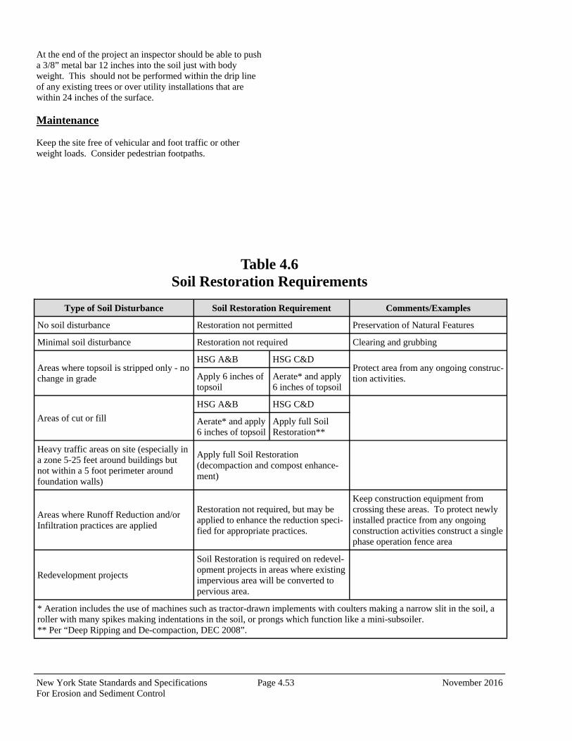
New York State Standards and Specifications Page 4.53 November 2016 For Erosion and Sediment Control
Type of Soil Disturbance Soil Restoration Requirement Comments/Examples
No soil disturbance Restoration not permitted Preservation of Natural Features
Minimal soil disturbance Restoration not required Clearing and grubbing
Areas where topsoil is stripped only - no change in grade
HSG A&B HSG C&D Protect area from any ongoing construc-tion activities. Apply 6 inches of
topsoil Aerate* and apply 6 inches of topsoil
Areas of cut or fill
HSG A&B HSG C&D
Aerate* and apply 6 inches of topsoil
Apply full Soil Restoration**
Heavy traffic areas on site (especially in a zone 5-25 feet around buildings but not within a 5 foot perimeter around foundation walls)
Apply full Soil Restoration (decompaction and compost enhance-ment)
Areas where Runoff Reduction and/or Infiltration practices are applied
Restoration not required, but may be applied to enhance the reduction speci-fied for appropriate practices.
Keep construction equipment from crossing these areas. To protect newly installed practice from any ongoing construction activities construct a single phase operation fence area
Redevelopment projects
Soil Restoration is required on redevel-opment projects in areas where existing impervious area will be converted to pervious area.
* Aeration includes the use of machines such as tractor-drawn implements with coulters making a narrow slit in the soil, a roller with many spikes making indentations in the soil, or prongs which function like a mini-subsoiler. ** Per “Deep Ripping and De-compaction, DEC 2008”.
Table 4.6 Soil Restoration Requirements
At the end of the project an inspector should be able to push a 3/8” metal bar 12 inches into the soil just with body weight. This should not be performed within the drip line of any existing trees or over utility installations that are within 24 inches of the surface. Maintenance Keep the site free of vehicular and foot traffic or other weight loads. Consider pedestrian footpaths.
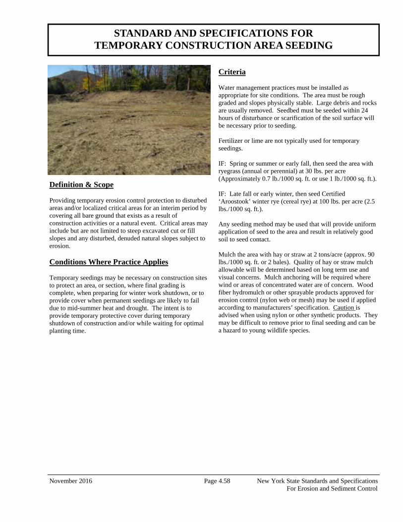
November 2016 Page 4.58 New York State Standards and Specifications For Erosion and Sediment Control
Definition & Scope Providing temporary erosion control protection to disturbed areas and/or localized critical areas for an interim period by covering all bare ground that exists as a result of construction activities or a natural event. Critical areas may include but are not limited to steep excavated cut or fill slopes and any disturbed, denuded natural slopes subject to erosion. Conditions Where Practice Applies Temporary seedings may be necessary on construction sites to protect an area, or section, where final grading is complete, when preparing for winter work shutdown, or to provide cover when permanent seedings are likely to fail due to mid-summer heat and drought. The intent is to provide temporary protective cover during temporary shutdown of construction and/or while waiting for optimal planting time.
Criteria Water management practices must be installed as appropriate for site conditions. The area must be rough graded and slopes physically stable. Large debris and rocks are usually removed. Seedbed must be seeded within 24 hours of disturbance or scarification of the soil surface will be necessary prior to seeding. Fertilizer or lime are not typically used for temporary seedings. IF: Spring or summer or early fall, then seed the area with ryegrass (annual or perennial) at 30 lbs. per acre (Approximately 0.7 lb./1000 sq. ft. or use 1 lb./1000 sq. ft.). IF: Late fall or early winter, then seed Certified ‘Aroostook’ winter rye (cereal rye) at 100 lbs. per acre (2.5 lbs./1000 sq. ft.). Any seeding method may be used that will provide uniform application of seed to the area and result in relatively good soil to seed contact. Mulch the area with hay or straw at 2 tons/acre (approx. 90 lbs./1000 sq. ft. or 2 bales). Quality of hay or straw mulch allowable will be determined based on long term use and visual concerns. Mulch anchoring will be required where wind or areas of concentrated water are of concern. Wood fiber hydromulch or other sprayable products approved for erosion control (nylon web or mesh) may be used if applied according to manufacturers’ specification. Caution is advised when using nylon or other synthetic products. They may be difficult to remove prior to final seeding and can be a hazard to young wildlife species.
STANDARD AND SPECIFICATIONS FOR TEMPORARY CONSTRUCTION AREA SEEDING
Appendix B – Construction Log Book
Contents
Notice of Intent
SPDES General Permit
DEC Acknowledgement Letter
Pre-Construction Meeting Documents
Inspection Log
Weekly Inspection Reports
Modification to the SWPPP
Monthly Inspection Summary
Three-Month Status Report
Final Stabilization and Retention Records
NYS DEC & NYC DEP Compliance Inspection
Notice of Termination

DRAFT FOR PUBLIC COMMENT
NEW YORK STATE
DEPARTMENT OF ENVIRONMENTAL CONSERVATION SPDES GENERAL PERMIT
FOR STORMWATER DISCHARGES
From
CONSTRUCTION ACTIVITY
Permit No. GP-0-15-002
Issued Pursuant to Article 17, Titles 7, 8 and Article 70 of the Environmental Conservation Law
Effective Date: Expiration Date: John J. Ferguson Chief Permit Administrator Authorized Signature Date Address: NYS DEC
Division of Environmental Permits 625 Broadway, 4th Floor Albany, N.Y. 12233-1750
2
PREFACE Pursuant to Section 402 of the Clean Water Act (“CWA”), stormwater discharges from certain construction activities are unlawful unless they are authorized by a National Pollutant Discharge Elimination System (“NPDES”) permit or by a state permit program. New York’s State Pollutant Discharge Elimination System (“SPDES”) is a NPDES-approved program with permits issued in accordance with the Environmental Conservation Law (“ECL”).
This general permit (“permit”) is issued pursuant to Article 17, Titles 7, 8 and Article 70 of the ECL. An owner or operator may obtain coverage under this permit by submitting a Notice of Intent ("NOI") to the Department. Copies of this permit and the NOI for New York are available by calling (518) 402-8109 or at any New York State Department of Environmental Conservation (“the Department”) regional office (see Appendix G).They are also available on the Department’s website at:
http://www.dec.ny.gov/
An owner or operator of a construction activity that is eligible for coverage under this permit must obtain coverage prior to the commencement of construction activity. Activities that fit the definition of “construction activity”, as defined under 40 CFR 122.26(b)(14)(x), (15)(i), and (15)(ii), constitute construction of a point source and therefore, pursuant to Article 17-0505 of the ECL, the owner or operator must have coverage under a SPDES permit prior to commencing construction activity. They cannot wait until there is an actual discharge from the construction site to obtain permit coverage. *Note: The italicized words/phrases within this permit are defined in Appendix A.
3
NEW YORK STATE DEPARTMENT OF ENVIRONMENTAL CONSERVATION SPDES GENERAL PERMIT FOR STORMWATER DISCHARGES
FROM CONSTRUCTION ACTIVITIES Part I. PERMIT COVERAGE AND LIMITATIONS ....................................................................... 5
A. Permit Application .................................................................................................................... 5 B. Effluent Limitations Applicable to Discharges from Construction Activities .......................... 5 C. Post-construction Stormwater Management Practice Requirements ....................................... 7 D. Maintaining Water Quality ..................................................................................................... 11 E. Eligibility Under This General Permit .................................................................................... 12 F. Activities Which Are Ineligible for Coverage Under This General Permit ............................ 12
Part II. OBTAINING PERMIT COVERAGE ................................................................................ 14 A. Notice of Intent (NOI) Submittal ............................................................................................ 14 B. Permit Authorization ............................................................................................................... 15 C. General Requirements For Owners or Operators With Permit Coverage ............................... 17 D. Permit Coverage for Discharges Authorized Under GP-0-10-001 ......................................... 19 E. Change of Owner or Operator ................................................................................................. 19
Part III. STORMWATER POLLUTION PREVENTION PLAN (SWPPP) ................................... 19 A. General SWPPP Requirements ............................................................................................... 19 B. Required SWPPP Contents ..................................................................................................... 22 C. Required SWPPP Components by Project Type ..................................................................... 25
Part IV. INSPECTION AND MAINTENANCE REQUIREMENTS ............................................. 25 A. General Construction Site Inspection and Maintenance Requirements .................................. 25 B. Trained Contractor Maintenance Inspection Requirements .................................................... 25 C. Qualified Inspector Inspection Requirements ......................................................................... 26
Part V. TERMINATION OF PERMIT COVERAGE ..................................................................... 29 A. Termination of Permit Coverage ............................................................................................. 29
Part VI. REPORTING AND RETENTION OF RECORDS ........................................................... 31 A. Record Retention .................................................................................................................... 31 B. Addresses ................................................................................................................................ 31
Part VII. STANDARD PERMIT CONDITIONS ........................................................................... 31 A. Duty to Comply ....................................................................................................................... 31 B. Continuation of the Expired General Permit ........................................................................... 32 C. Enforcement ............................................................................................................................ 32 D. Need to Halt or Reduce Activity Not a Defense ..................................................................... 32 E. Duty to Mitigate ...................................................................................................................... 32 F. Duty to Provide Information .................................................................................................... 32 G. Other Information ................................................................................................................... 32 H. Signatory Requirements .......................................................................................................... 33 I. Property Rights ......................................................................................................................... 34 J. Severability ............................................................................................................................... 34 K. Requirement to Obtain Coverage Under an Alternative Permit ............................................. 35 L. Proper Operation and Maintenance ......................................................................................... 35 M. Inspection and Entry ............................................................................................................... 35 N. Permit Actions......................................................................................................................... 36 O. Definitions ............................................................................................................................... 36
4
P. Re-Opener Clause .................................................................................................................... 36 Q. Penalties for Falsification of Forms and Reports .................................................................... 36 R. Other Permits........................................................................................................................... 36
APPENDIX A - Definitions ............................................................................................................. 37 APPENDIX B – Required SWPPP Components by Project Type .................................................. 43 APPENDIX C – Watersheds Where Enhanced Phosphorous Removal Standards are Required ... 45 APPENDIX D – Watersheds Where 5000 SF Disturbances and Greater Must Obtain Permit Coverage .......................................................................................................................................... 51 APPENDIX E – List of 303(d) Segments That Require SWPPP With Post-Construction Stormwater Management Practices ................................................................................................. 52 APPENDIX F – DEC Regional Office Contact Information .......................................................... 53
5
Part I. PERMIT COVERAGE AND LIMITATIONS
A. Permit Application - This permit authorizes stormwater discharges to surface waters of the State from the following construction activities identified within 40 CFR Parts 122.26(b)(14)(x), 122.26(b)(15)(i) and 122.26(b)(15)(ii), provided all of the eligibility provisions of this permit are met:
1. Construction activities involving soil disturbances of one (1) or more acres;
including disturbances of less than one acre that are part of a larger common plan of development or sale that will ultimately disturb one or more acres of land; excluding routine maintenance activity that is performed to maintain the original line and grade, hydraulic capacity or original purpose of a facility;
2. Construction activities involving soil disturbances of less than one (1) acre where
the Department has determined that a SPDES permit is required for stormwater discharges based on the potential for contribution to a violation of a water quality standard or for significant contribution of pollutants to surface waters of the State.
3. Construction activities located in the watershed(s) identified in Appendix D that
involve soil disturbances between five thousand (5,000) square feet and one (1) acre of land.
B. Effluent Limitations Applicable to Discharges from Construction Activities -
Discharges authorized by this permit must achieve, at a minimum, the effluent limitations in Part I.B.1.(a) – (f) of this permit. These limitations represent the degree of effluent reduction attainable by the application of best practicable technology currently available.
1. Erosion and Sediment Control Requirements - The owner or operator must select,
design, install, implement and maintain control measures (including best management practices) to minimize the discharge of pollutants and prevent a violation of the water quality standards. The selection, design, installation, and implementation of these control measures must meet the non-numeric effluent limitations in Part I.B.1.(a) – (f) of this permit and be in accordance with the New York State Standards and Specifications for Erosion and Sediment Control, dated August 2005, using sound engineering judgment. Where control measures are not designed in conformance with the design criteria included in the technical standard, the owner or operator must include in the Stormwater Pollution Prevention Plan (“SWPPP”) the reason(s) for the deviation or alternative design and provide information which demonstrates that the deviation or alternative design is equivalent to the technical standard.
a. Erosion and Sediment Controls. Design, install and maintain effective erosion and sediment controls to minimize the discharge of pollutants and prevent a violation of the water quality standards. At a minimum, such controls must be designed, installed and maintained to:
6
(i) Minimize soil erosion through application of runoff control and soil stabilization control measure to minimize pollutant discharges;
(ii) Control stormwater discharges to minimize channel and streambank erosion and scour in the immediate vicinity of the discharge points;
(iii) Minimize the amount of soil exposed during construction activity;
(iv) Minimize the disturbance of steep slopes; (v) Minimize sediment discharges from the site; (vi) Provide and maintain natural buffers around surface waters, direct stormwater to vegetated areas and maximize stormwater infiltration to reduce pollutant discharges, unless infeasible; (vii) Minimize soil compaction. Minimizing soil compaction is not required where the intended function of a specific area of the site dictates that it be compacted; and (viii) Unless infeasible, preserve a sufficient amount of topsoil to complete soil restoration and establish a uniform, dense vegetative cover.
b. Soil Stabilization. In areas where soil disturbance activity has temporarily or permanently ceased, the application of soil stabilization measures must be initiated by the end of the next business day and completed within 14 days from the date the current soil disturbance activity ceased.
c. Dewatering. Discharges from dewatering activities, including discharges from dewatering of trenches and excavations, must be managed by appropriate control measures.
d. Pollution Prevention Measures. Design, install, implement, and maintain effective pollution prevention measures to minimize the discharge of pollutants and prevent a violation of the water quality standards. At a minimum, such measures must be designed, installed, implemented and maintained to: (i) Minimize the discharge of pollutants from equipment and vehicle washing, wheel wash water, and other wash waters. This applies to washing operations that use clean water only. Soaps, detergents and solvents cannot be used; (ii) Minimize the exposure of building materials, building products, construction wastes, trash, landscape materials, fertilizers, pesticides, herbicides, detergents, sanitary waste and other materials present on the site to precipitation and to
7
stormwater. Minimization of exposure is not required in cases where the exposure to precipitation and to stormwater will not result in a discharge of pollutants, or where exposure of a specific material or product poses little risk of stormwater contamination (such as final products and materials intended for outdoor use) ; and
(iii) Prevent the discharge of pollutants from spills and leaks and implement
chemical spill and leak prevention and response procedures.
e. Prohibited Discharges. The following discharges are prohibited:
(i) Wastewater from washout of concrete;
(ii) Wastewater from washout and cleanout of stucco, paint, form release oils, curing compounds and other construction materials; (iii) Fuels, oils, or other pollutants used in vehicle and equipment operation
and maintenance; and (iv) Soaps or solvents used in vehicle and equipment washing.
f. Surface Outlets. When discharging from basins and impoundments, the outlets shall be designed, constructed and maintained in such a manner that sediment does not leave the basin or impoundment and that erosion at or below the outlet does not occur.
C. Post-construction Stormwater Management Practice Requirements -
1. The owner or operator of a construction activity that requires post-construction
stormwater management practices pursuant to Part III.C. of this permit must select, design, install, and maintain the practices to meet the performance criteria in the New York State Stormwater Management Design Manual (“Design Manual”), dated (pending), using sound engineering judgment. Where post-construction stormwater management practices (“SMPs”) are not designed in conformance with the performance criteria in the Design Manual, the owner or operator must include in the SWPPP the reason(s) for the deviation or alternative design and provide information which demonstrates that the deviation or alternative design is equivalent to the technical standard.
2. The owner or operator of a construction activity that requires post-construction
stormwater management practices pursuant to Part III.C. of this permit must design the practices to meet the applicable sizing criteria in Part I.C.2.a., b., c. or d. of this permit.
a. Sizing Criteria for New Development
(i) Runoff Reduction Volume (“RRv”): Reduce the total Water Quality
8
Volume (“WQv”) by application of RR techniques and standard SMPs with RRv capacity. The total WQv shall be calculated in accordance with the criteria in Section 4.2 of the Design Manual.
(ii) Minimum RRv and Treatment of Remaining Total WQv: Construction activities that cannot meet the criteria in Part I.C.2.a.(i) of this permit due to site limitations shall direct runoff from all newly constructed impervious areas to a RR technique or standard SMP with RRv capacity unless infeasible. The specific site limitations that prevent the reduction of 100% of the WQv shall be documented in the SWPPP. For each impervious area that is not directed to a RR technique or standard SMP with RRv capacity, the SWPPP must document the site limitations that make it infeasible.
In no case shall the runoff reduction achieved from the newly constructed impervious areas be less than the Minimum RRv as calculated using the criteria in Section 4.3 of the Design Manual. The remaining portion of the total WQv that cannot be reduced shall be treated by application of standard SMPs.
(iii) Channel Protection Volume (“Cpv”): Provide 24 hour extended detention of the post-developed 1-year, 24-hour storm event; remaining after runoff reduction. The Cpv requirement does not apply when:
(1) Reduction of the entire Cpv is achieved by application of runoff reduction techniques or infiltration systems, or
(2) The site discharges directly to tidal waters, or fifth order or larger streams.
(iv) Overbank Flood Control Criteria (“Qp”): Requires storage to attenuate the post-development 10-year, 24-hour peak discharge rate (Qp) to predevelopment rates. The Qp requirement does not apply when:
(1) the site discharges directly to tidal waters or fifth order or larger streams, or
(2) A downstream analysis reveals that overbank control is not required.
(v) Extreme Flood Control Criteria (“Qf”): Requires storage to attenuate the post-development 100-year, 24-hour peak discharge rate (Qf) to predevelopment rates. The Qf requirement does not apply when:
(1) the site discharges directly to tidal waters or fifth order or larger streams, or
(2) A downstream analysis reveals that overbank control is not required.
9
b. Sizing Criteria for New Development in Enhanced Phosphorus Removal Watershed
(i) Runoff Reduction Volume (RRv): Reduce the total Water Quality Volume (WQv) by application of RR techniques and standard SMPs with RRv capacity. The total WQv is the runoff volume from the 1-year, 24 hour design storm over the post-developed watershed and shall be calculated in accordance with the criteria in Section 10.3 of the Design Manual.
(ii) Minimum RRv and Treatment of Remaining Total WQv: Construction activities that cannot meet the criteria in Part I.C.2.b.(i) of this permit due to site limitations shall direct runoff from all newly constructed impervious areas to a RR technique or standard SMP with RRv capacity unless infeasible. The specific site limitations that prevent the reduction of 100% of the WQv shall be documented in the SWPPP. For each impervious area that is not directed to a RR technique or standard SMP with RRv capacity, the SWPPP must document the site limitations that make it infeasible. In no case shall the runoff reduction achieved from the newly constructed impervious areas be less than the Minimum RRv as calculated using the criteria in Section 10.3 of the Design Manual. The remaining portion of the total WQv that cannot be reduced shall be treated by application of standard SMPs.
(iii) Channel Protection Volume (Cpv): Provide 24 hour extended detention of the post-developed 1-year, 24-hour storm event; remaining after runoff reduction. The Cpv requirement does not apply when:
(1) Reduction of the entire Cpv is achieved by application of runoff reduction techniques or infiltration systems, or
(2) the site discharges directly to tidal waters, or fifth order or larger streams.
(iv) Overbank Flood Control Criteria (Qp): Requires storage to attenuate the post-development 10-year, 24-hour peak discharge rate (Qp) to predevelopment rates. The Qp requirement does not apply when:
(1) the site discharges directly to tidal waters or fifth order or larger streams, or
(2) A downstream analysis reveals that overbank control is not required.
10
(v) Extreme Flood Control Criteria (Qf): Requires storage to attenuate the post-development 100-year, 24-hour peak discharge rate (Qf) to predevelopment rates. The Qf requirement does not apply when:
(1) the site discharges directly to tidal waters or fifth order or larger streams, or
(2) A downstream analysis reveals that overbank control is not required.
c. Sizing Criteria for Redevelopment Activity
(i) Water Quality Volume (WQv): The WQv treatment objective for redevelopment activity shall be addressed by one of the following options. Redevelopment activities located in an Enhanced Phosphorus Removal Watershed (see Part III.B.3. and Appendix C of this permit) shall calculate the WQv in accordance with Section 10.3 of the Design Manual. All other redevelopment activities shall calculate the WQv in accordance with Section 4.2 of the Design Manual.
(1) Reduce the existing impervious cover by a minimum of 25% of the total disturbed, impervious area. The Soil Restoration criteria in Section 5.1.6 of the Design Manual must be applied to all newly created pervious areas, or
(2) Capture and treat a minimum of 25% of the WQv from the disturbed, impervious area by the application of standard SMPs; or reduce this WQv by the application of RR techniques or standard SMPs with RRv capacity., or
(3) Capture and treat a minimum of 75% of the WQv from the disturbed, impervious area as well as any additional runoff from tributary areas by application of the alternative practices discussed in Sections 9.4 and 9.5 of the Design Manual., or
(4) Application of a combination of 1, 2 and 3 above that provide a weighted average of at least two of the above methods. Application of this method shall be in accordance with the criteria in Section 9.3.2 (B)(IV) of the Design Manual.
If there is an existing post-construction stormwater management practice located on the site that captures and treats runoff from the impervious area that is being disturbed, the WQv treatment option selected must, at a minimum, provide treatment equal to the treatment that was being provided by the existing practice(s) if that treatment is greater than the treatment required by options 1 – 4 above.
(ii) Channel Protection Volume (Cpv): Not required if there are no
changes to hydrology that increase the discharge rate from the
11
project site.
(iii) Overbank Flood Control Criteria (Qp): Not required if there are no changes to hydrology that increase the discharge rate from the project site.
(iv) Extreme Flood Control Criteria (Qf): Not required if there are no
changes to hydrology that increase the discharge rate from the project site.
d. Sizing Criteria for Combination of Redevelopment Activity and New Development
Construction projects that include both New Development and Redevelopment Activity shall meet the applicable Sizing Criteria in Part I.C.2.a. or b. of this permit for the New Development portion of the project and Part I.C.2.c of this permit for Redevelopment Activity portion of the project.
D. Maintaining Water Quality – The Department expects that compliance with the conditions of this permit will control discharges necessary to meet applicable water quality standards. It shall be a violation of the ECL for any discharge to either cause or contribute to a violation of water quality standards as contained in Parts 700 through 705 of Title 6 of the Official Compilation of Codes, Rules and Regulations of the State of New York, such as:
1. There shall be no increase in turbidity that will cause a substantial visible
contrast to natural conditions;
2. There shall be no increase in suspended, colloidal or settleable solids that will cause deposition or impair the waters for their best usages; and
3. There shall be no residue from oil and floating substances, nor visible oil film, nor globules of grease.
If there is evidence indicating that the stormwater discharges authorized by this permit are causing, have the reasonable potential to cause, or are contributing to a violation of the water quality standards; the owner or operator must take appropriate corrective action and document in accordance with Part IV.C.4. of this permit. To address the water quality standard violation the owner or operator may need to provide additional information, include and implement appropriate controls in the SWPPP to correct the problem, or obtain an individual SPDES permit. If there is evidence indicating that despite compliance with the terms and conditions of this permit it is demonstrated that the stormwater discharges authorized by this permit are
12
causing or contributing to a violation of water quality standards, or if the Department determines that a modification of the permit is necessary to prevent a violation of water quality standards, the authorized discharges will no longer be eligible for coverage under this permit. The Department may require the owner or operator to obtain an individual SPDES permit to continue discharging.
E. Eligibility Under This General Permit
1. This permit may authorize all discharges of stormwater from construction activity
to surface waters of the State and groundwaters except for ineligible discharges identified under subparagraph F. of this Part.
2. Except for non-stormwater discharges explicitly listed in the next paragraph, this
permit only authorizes stormwater discharges from construction activities.
3. Notwithstanding paragraphs E.1 and E.2 above, the following non-stormwater discharges may be authorized by this permit: discharges from firefighting activities; fire hydrant flushings; waters to which cleansers or other components have not been added that are used to wash vehicles or control dust in accordance with the SWPPP, routine external building washdown which does not use detergents; pavement washwaters where spills or leaks of toxic or hazardous materials have not occurred (unless all spilled material has been removed) and where detergents are not used; air conditioning condensate; uncontaminated groundwater or spring water; uncontaminated discharges from construction site de-watering operations; and foundation or footing drains where flows are not contaminated with process materials such as solvents. For those entities required to obtain coverage under this permit, and who discharge as noted in this paragraph, and with the exception of flows from firefighting activities, these discharges must be identified in the SWPPP. Under all circumstances, the owner or operator must still comply with water quality standards in Part I.D of this permit.
4. The owner or operator must maintain permit eligibility to discharge under this
permit. Any discharges that are not compliant with the eligibility conditions of this permit are not authorized by the permit and the owner or operator must either apply for a separate permit to cover those ineligible discharges or take steps necessary to make the discharge eligible for coverage.
F. Activities Which Are Ineligible for Coverage Under This General Permit - All of the following are not authorized by this permit:
1. Discharges after construction activities have been completed and the site has
undergone final stabilization;
2. Discharges that are mixed with sources of non-stormwater other than those expressly authorized under subsection E.3. of this Part and identified in the SWPPP
13
required by this permit;
3. Discharges that are required to obtain an individual SPDES permit or another SPDES general permit pursuant to Part VII.K. of this permit;
4. Discharges from construction activities that may adversely affect an endangered or
threatened species unless the owner or operator has obtained a permit issued pursuant to 6 NYCRR Part 182 for the project or the Department has issued a letter of non-jurisdiction for the project. All documentation necessary to demonstrate eligibility shall be maintained on site in accordance with Part II.C.2 of this permit.
5. Discharges which either cause or contribute to a violation of water quality
standards adopted pursuant to the ECL and its accompanying regulations;
6. Construction activities for residential, commercial and institutional projects: a. where the discharges from the construction activities are tributary to waters of the state classified as AA or AA-s; and
b. which disturb one or more acres of land with no existing impervious
cover; and
c. which are undertaken on land with a Soil Slope Phase that is identified as an E or F, or the map unit name is inclusive of 25% or greater slope, on the United States Department of Agriculture (“USDA”) Soil Survey for the County where the disturbance will occur.
7. Construction activities for linear transportation projects and linear utility projects:
a. where the discharges from the construction activities are tributary to waters of the state classified as AA or AA-s; and
b. which disturb two or more acres of land with no existing impervious cover; and c. which are undertaken on land with a Soil Slope Phase that is identified as an E or F, or the map unit name is inclusive of 25% or greater slope, on the USDA Soil Survey for the County where the disturbance will occur.
8. Construction activities that have the potential to affect a property or place
(buildings, sites, structures, districts or objects) that is listed or determined to be eligible for listing on the National or State Registers of Historic Places or occur in an area that includes or is adjacent to a building or buildings that are more than 50 years old, unless there are written agreements in place with the NYS Office of Parks, Recreation and Historic Preservation (“OPRHP”) or other governmental

14
agencies to mitigate the effects, or there are local land use approvals evidencing the same. The following documentation necessary to demonstrate eligibility with this requirement shall be maintained on site in accordance with Part II.C.2 of this permit and made available to DEC in accordance with Part VII.F of this permit:
A map demonstrating that the construction activity is not within the archeological sensitive area indicated on the sensitivity map and not within or adjacent to a property or place listed on the National or State Registers of Historic Places or determined to be eligible for listing; and, photographs depicting all buildings in or adjacent to the project area are less than 50 years old; or,
State Environmental Quality Review (“SEQR”) Environmental Assessment Form (“EAF”) with a negative declaration or the Findings Statement that archeological and historic resources will not be affected; or,
Documentation that the construction activity will result in No Impact to archeologically sensitive areas, or historic properties or places listed on or determined to be eligible for listing on the National or State Register of Historic Places or properties that are more than 50 years old; or,
DEC form sent to OPRHP and copied to DEC Agency Preservation Officer (“APO”); and a letter from OPRHP providing a recommendation of No Adverse Impact; or,
A Letter of Resolution signed by the owner or operator, OPRHP and the DEC APO; or,
Under National Historic Preservation Act §106, a determination of No Affect, No Adverse Affect or a Memorandum of Agreement executed for a coterminous project area or a statement that the project is not being undertaken by or on behalf of a federal agency or does not require a federal permit, approval or funding.
9. Discharges from construction activities that are subject to an existing SPDES
individual or general permit where a SPDES permit for construction activity has been terminated or denied; or where the owner or operator has failed to renew an expired individual permit.
Part II. OBTAINING PERMIT COVERAGE
A. Notice of Intent (NOI) Submittal
1. An owner or operator of a construction activity that is not subject to the requirements of a regulated, traditional land use control MS4 must first prepare a SWPPP in accordance with all applicable requirements of this permit and then submit a completed NOI form to the Department in order to be authorized to discharge under this permit. An owner or operator shall use either the electronic (eNOI) or paper version of the NOI that the Department prepared. Both versions of the NOI are located on the Department’s website (http://www.dec.ny.gov/ ). The
15
paper version of the NOI shall be signed in accordance with Part VII.H. of this permit and submitted to the following address.
NOTICE OF INTENT NYS DEC, Bureau of Water Permits 625 Broadway, 4th Floor Albany, New York 12233-3505
2. An owner or operator of a construction activity that is subject to the requirements
of a regulated, traditional land use control MS4 must first prepare a SWPPP in accordance with all applicable requirements of this permit and then have its SWPPP reviewed and accepted by the regulated, traditional land use control MS4 prior to submitting the NOI to the Department. The owner or operator shall have the “MS4 SWPPP Acceptance” form signed in accordance with Part VII.H., and then submit that form along with a completed NOI to the Department. An owner or operator shall use either the electronic (eNOI) or paper version of the NOI. The paper version of the NOI shall be signed in accordance with Part VII.H. of this permit and submitted to the address in Part II.A.1. The requirement for an owner or operator to have its SWPPP reviewed and accepted by the MS4 prior to submitting the NOI to the Department does not apply to an owner or operator that is obtaining permit coverage in accordance with the requirements in Part II.E. (Change of Owner or Operator) or where the owner or operator of the construction activity is the regulated, traditional land use control MS4.
3. The owner or operator shall have the SWPPP preparer sign the “SWPPP Preparer Certification” statement on the NOI prior to submitting the form to the Department.
4. As of the date the NOI is submitted to the Department, the owner or operator shall make the NOI and SWPPP available for review and copying in accordance with the requirements in Part VII.F. of this permit.
B. Permit Authorization
1. An owner or operator shall not commence construction activity until their
authorization to discharge under this permit goes into effect.
2. Authorization to discharge under this permit will be effective when the owner or operator has satisfied all of the following criteria:
a. project review pursuant to the State Environmental Quality Review Act (“SEQRA”) have been satisfied, when SEQRA is applicable. See the Department’s website (http://www.dec.ny.gov/) for more information,
16
b. where required, all necessary Department permits subject to the Uniform Procedures Act (“UPA”) (see 6 NYCRR Part 621) have been obtained, unless otherwise notified by the Department pursuant to 6 NYCRR 621.3(a)(4). Owners or operators of construction activities that are required to obtain UPA permits must submit a preliminary SWPPP to the appropriate DEC Permit Administrator at the Regional Office listed in Appendix F at the time all other necessary UPA permit applications are submitted. The preliminary SWPPP must include sufficient information to demonstrate that the construction activity qualifies for authorization under this permit,
c. the final SWPPP has been prepared, and
d. a complete NOI has been submitted to the Department in accordance with the requirements of this permit.
3. An owner or operator that has satisfied the requirements of Part II.B.2 above will
be authorized to discharge stormwater from their construction activity in accordance with the following schedule:
a. For construction activities that are not subject to the requirements of a regulated, traditional land use control MS4:
i. Five (5) business days from the date the Department receives a complete electronic version of the NOI (eNOI) for construction activities with a SWPPP that has been prepared in conformance with the design criteria in the technical standard referenced in Part III.B.1 and the performance criteria in the technical standard referenced in Parts III.B., 2 or 3, for construction activities that require post-construction stormwater management practices pursuant to Part III.C.; or ii. Sixty (60) business days from the date the Department receives a complete NOI (electronic or paper version) for construction activities with a SWPPP that has not been prepared in conformance with the design criteria in technical standard referenced in Part III.B.1. or, for construction activities that require post-construction stormwater management practices pursuant to Part III.C., the performance criteria in the technical standard referenced in Parts III.B., 2 or 3, or; iii. Fourteen (14) business days from the date the Department receives a complete paper version of the NOI for construction activities with a SWPPP that has been prepared in conformance with the design criteria in the technical standard referenced in Part III.B.1 and the performance criteria in the technical standard referenced in
17
Parts III.B., 2 or 3, for construction activities that require post-construction stormwater management practices pursuant to Part III.C.
b. For construction activities that are subject to the requirements of a regulated, traditional land use control MS4:
i. Five (5) business days from the date the Department receives both a complete electronic version of the NOI (eNOI) and signed “MS4 SWPPP Acceptance” form, or
ii. Fourteen (14) business days from the date the Department receives both a complete paper version of the NOI and signed “MS4 SWPPP Acceptance” form.
4. The Department may suspend or deny an owner’s or operator’s coverage under this
permit if the Department determines that the SWPPP does not meet the permit requirements. In accordance with statute, regulation, and the terms and conditions of this permit, the Department may deny coverage under this permit and require submittal of an application for an individual SPDES permit based on a review of the NOI or other information pursuant to Part II.
5. Coverage under this permit authorizes stormwater discharges from only those areas
of disturbance that are identified in the NOI. If an owner or operator wishes to have stormwater discharges from future or additional areas of disturbance authorized, they must submit a new NOI that addresses that phase of the development, unless otherwise notified by the Department. The owner or operator shall not commence construction activity on the future or additional areas until their authorization to discharge under this permit goes into effect in accordance with Part II.B. of this permit.
C. General Requirements For Owners or Operators With Permit Coverage
1. The owner or operator shall ensure that the provisions of the SWPPP are
implemented from the commencement of construction activity until all areas of disturbance have achieved final stabilization and the Notice of Termination (“NOT”) has been submitted to the Department in accordance with Part V. of this permit. This includes any changes made to the SWPPP pursuant to Part III.A.4. of this permit.
2. The owner or operator shall maintain a copy of the General Permit (GP-0-15-002),
NOI, NOI Acknowledgment Letter, SWPPP, MS4 SWPPP Acceptance form, inspection reports, and all documentation necessary to demonstrate eligibility with this permit at the construction site until all disturbed areas have achieved final stabilization and the NOT has been submitted to the Department. The documents
18
must be maintained in a secure location, such as a job trailer, on-site construction office, or mailbox with lock. The secure location must be accessible during normal business hours to an individual performing a compliance inspection.
3. The owner or operator of a construction activity shall not disturb greater than five
(5) acres of soil at any one time without prior written authorization from the Department or, in areas under the jurisdiction of a regulated, traditional land use control MS4, the regulated, traditional land use control MS4 (provided the regulated, traditional land use control MS4 is not the owner or operator of the construction activity). At a minimum, the owner or operator must comply with the following requirements in order to be authorized to disturb greater than five (5) acres of soil at any one time:
a. The owner or operator shall have a qualified inspector conduct at least two (2) site inspections in accordance with Part IV.C. of this permit every seven (7) calendar days, for as long as greater than five (5) acres of soil remain disturbed. The two (2) inspections shall be separated by a minimum of two (2) full calendar days.
b. In areas where soil disturbance activity has temporarily or permanently ceased, the application of soil stabilization measures must be initiated by the end of the next business day and completed within seven (7) days from the date the current soil disturbance activity ceased. The soil stabilization measures selected shall be in conformance with the technical standard, New York State Standards and Specifications for Erosion and Sediment Control, dated August 2005. c. The owner or operator shall prepare a phasing plan that defines maximum disturbed area per phase and shows required cuts and fills.
d. The owner or operator shall install any additional site specific practices needed to protect water quality.
e. The owner or operator shall include the requirements above in their SWPPP.
4. In accordance with statute, regulations, and the terms and conditions of this permit,
the Department may suspend or revoke an owner’s or operator’s coverage under this permit at any time if the Department determines that the SWPPP does not meet the permit requirements. Upon a finding of significant non-compliance with the practices described in the SWPPP or violation of this permit, the Department may order an immediate stop to all activity at the site until the non-compliance is remedied. The stop work order shall be in writing, describe the non-compliance in detail, and be sent to the owner or operator.
19
5. For construction activities that are subject to the requirements of a regulated, traditional land use control MS4, the owner or operator shall notify the regulated, traditional land use control MS4 in writing of any planned amendments or modifications to the post-construction stormwater management practice component of the SWPPP required by Part III.A. 4. and 5. of this permit. Unless otherwise notified by the regulated, traditional land use control MS4, the owner or operator shall have the SWPPP amendments or modifications reviewed and accepted by the regulated, traditional land use control MS4 prior to commencing construction of the post-construction stormwater management practice.
D. Permit Coverage for Discharges Authorized Under GP-0-10-001
1. Upon renewal of SPDES General Permit for Stormwater Discharges from
Construction Activity (Permit No. GP-0-10-001), an owner or operator of a construction activity with coverage under GP-0-10-001, as of the effective date of GP-0-15-002, shall be authorized to discharge in accordance with GP-0-15-002, unless otherwise notified by the Department.
An owner or operator may continue to implement the requirements in Part III.B. of GP-0-10-001. However, they must comply with all other requirements of this permit as of the effective date.
E. Change of Owner or Operator
1. When property ownership changes or when there is a change in operational control
over the construction plans and specifications, the original owner or operator must notify the new owner or operator, in writing, of the requirement to obtain permit coverage by submitting a NOI with the Department. Once the new owner or operator obtains permit coverage, the original owner or operator shall then submit a completed NOT with the name and permit identification number of the new owner or operator to the Department at the address in Part II.A.1. of this permit. If the original owner or operator maintains ownership of a portion of the construction activity and will disturb soil, they must maintain their coverage under the permit.
Permit coverage for the new owner or operator will be effective as of the date the Department receives a complete NOI, provided the original owner or operator was not subject to a sixty (60) business day authorization period that has not expired as of the date the Department receives the NOI from the new owner or operator.
Part III. STORMWATER POLLUTION PREVENTION PLAN (SWPPP)
A. General SWPPP Requirements
1. A SWPPP shall be prepared and implemented by the owner or operator of each
20
construction activity covered by this permit. The SWPPP must document the selection, design, installation, implementation and maintenance of the control measures and practices that will be used to meet the effluent limitations in Part I.B. of this permit and where applicable, the post-construction stormwater management practice requirements in Part I.C. of this permit. The SWPPP shall be prepared prior to the submittal of the NOI. The NOI shall be submitted to the Department prior to the commencement of construction activity. A copy of the completed, final NOI shall be included in the SWPPP.
2. The SWPPP shall describe the erosion and sediment control practices and where
required, post-construction stormwater management practices that will be used and/or constructed to reduce the pollutants in stormwater discharges and to assure compliance with the terms and conditions of this permit. In addition, the SWPPP shall identify potential sources of pollution which may reasonably be expected to affect the quality of stormwater discharges.
3. All SWPPPs that require the post-construction stormwater management practice
component shall be prepared by a qualified professional that is knowledgeable in the principles and practices of stormwater management and treatment.
4. The owner or operator must keep the SWPPP current so that it at all times accurately documents the erosion and sediment controls practices that are being used or will be used during construction, and all post-construction stormwater management practices that will be constructed on the site. At a minimum, the owner or operator shall amend the SWPPP: a. whenever the current provisions prove to be ineffective in minimizing pollutants in stormwater discharges from the site;
b. whenever there is a change in design, construction, or operation at the construction site that has or could have an effect on the discharge of pollutants; and
c. to address issues or deficiencies identified during an inspection by the qualified inspector, the Department or other regulatory authority.
5. The Department may notify the owner or operator at any time that the SWPPP does not meet one or more of the minimum requirements of this permit. The notification shall be in writing and identify the provisions of the SWPPP that require modification. Within fourteen (14) calendar days of such notification, or as otherwise indicated by the Department, the owner or operator shall make the required changes to the SWPPP and submit written notification to the Department that the changes have been made. If the owner or operator does not respond to the Department’s comments in the specified time frame, the Department may suspend the owner’s or operator’s coverage under this permit or require the owner or
21
operator to obtain coverage under an individual SPDES permit in accordance with Part II.C.4. of this permit.
6. Prior to the commencement of construction activity, the owner or operator must identify the contractor(s) and subcontractor(s) that will be responsible for installing, constructing, repairing, replacing, inspecting and maintaining the erosion and sediment control practices included in the SWPPP; and the contractor(s) and subcontractor(s) that will be responsible for constructing the post-construction stormwater management practices included in the SWPPP. The owner or operator shall have each of the contractors and subcontractors identify at least one person from their company that will be responsible for implementation of the SWPPP. This person shall be known as the trained contractor. The owner or operator shall ensure that at least one trained contractor is on site on a daily basis when soil disturbance activities are being performed.
The owner or operator shall have each of the contractors and subcontractors identified above sign a copy of the following certification statement below before they commence any construction activity:
"I hereby certify under penalty of law that I understand and agree to comply with the terms and conditions of the SWPPP and agree to implement any corrective actions identified by the qualified inspector during a site inspection. I also understand that the owner or operator must comply with the terms and conditions of the most current version of the New York State Pollutant Discharge Elimination System ("SPDES") general permit for stormwater discharges from construction activities and that it is unlawful for any person to cause or contribute to a violation of water quality standards. Furthermore, I am aware that there are significant penalties for submitting false information, that I do not believe to be true, including the possibility of fine and imprisonment for knowing violations"
In addition to providing the certification statement above, the certification page must also identify the specific elements of the SWPPP that each contractor and subcontractor will be responsible for and include the name and title of the person providing the signature; the name and title of the trained contractor responsible for SWPPP implementation; the name, address and telephone number of the contracting firm; the address (or other identifying description) of the site; and the date the certification statement is signed. The owner or operator shall attach the certification statement(s) to the copy of the SWPPP that is maintained at the construction site. If new or additional contractors are hired to implement measures identified in the SWPPP after construction has commenced, they must also sign the certification statement and provide the information listed above.
7. For projects where the Department requests a copy of the SWPPP or inspection
reports, the owner or operator shall submit the documents in both electronic
22
(PDFonly) and paper format within five (5) business days, unless otherwise notified by the Department.
B. Required SWPPP Contents
1. Erosion and sediment control component - All SWPPPs prepared pursuant to this
permit shall include erosion and sediment control practices designed in conformance with the technical standard, New York State Standards and Specifications for Erosion and Sediment Control, dated August 2005 . Where erosion and sediment control practices are not designed in conformance with the design criteria included in the technical standard, the owner or operator must demonstrate equivalence to the technical standard. At a minimum, the erosion and sediment control component of the SWPPP shall include the following:
a. Background information about the scope of the project, including the location, type and size of project;
b. A site map/construction drawing(s) for the project, including a general location map. At a minimum, the site map shall show the total site area; all improvements; areas of disturbance; areas that will not be disturbed; existing vegetation; on-site and adjacent off-site surface water(s); floodplain/floodway boundaries; wetlands and drainage patterns that could be affected by the construction activity; existing and final slopes; locations of different soil types with boundaries; material, waste, borrow or equipment storage areas located on adjacent properties; and location(s) of the stormwater discharge(s);
c. A description of the soil(s) present at the site, including an identification of the Hydrologic Soil Group (HSG);
d. A construction phasing plan and sequence of operations describing the intended order of construction activities, including clearing and grubbing, excavation and grading, utility and infrastructure installation and any other activity at the site that results in soil disturbance;
e. A description of the minimum erosion and sediment control practices to be installed or implemented for each construction activity that will result in soil disturbance. Include a schedule that identifies the timing of initial placement or implementation of each erosion and sediment control practice and the minimum time frames that each practice should remain in place or be implemented;
f. A temporary and permanent soil stabilization plan that meets the requirements of the technical standard, New York State Standards and Specifications for Erosion and Sediment Control, dated August 2005, for
23
each stage of the project, including initial land clearing and grubbing to project completion and achievement of final stabilization; g. A site map/construction drawing(s) showing the specific location(s), size(s), and length(s) of each erosion and sediment control practice;
h. The dimensions, material specifications, installation details, and operation and maintenance requirements for all erosion and sediment control practices. Include the location and sizing of any temporary sediment basins and structural practices that will be used to divert flows from exposed soils; i. A maintenance inspection schedule for the contractor(s) identified in Part III.A.6. of this permit, to ensure continuous and effective operation of the erosion and sediment control practices. The maintenance inspection schedule shall be in accordance with the requirements in the technical standard, New York State Standards and Specifications for Erosion and Sediment Control, dated August 2005;
j. A description of the pollution prevention measures that will be used to control litter, construction chemicals and construction debris from becoming a pollutant source in the stormwater discharges;
k. A description and location of any stormwater discharges associated with industrial activity other than construction at the site, including, but not limited to, stormwater discharges from asphalt plants and concrete plants located on the construction site; and l. Identification of any elements of the design that are not in conformance with the design criteria in the technical standard, New York State Standards and Specifications for Erosion and Sediment Control, dated August 2005. Include the reason for the deviation or alternative design and provide information which demonstrates that the deviation or alternative design is equivalent to the technical standard.
2. Post-construction stormwater management practice component – The owner or operator of any construction project identified in Table 2 of Appendix B as needing post-construction stormwater management practices shall prepare a SWPPP that includes practices designed in conformance with the applicable sizing criteria in Part I.C.2.a., c. or d. of this permit and the performance criteria in the technical standard, New York State Stormwater Management Design Manual dated (pending). Where post-construction stormwater management practices are not designed in conformance with the performance criteria in the technical standard, the owner or operator must include in the SWPPP the reason(s) for the deviation or alternative
24
design and provide information which demonstrates that the deviation or alternative design is equivalent to the technical standard. The post-construction stormwater management practice component of the SWPPP shall include the following:
a. Identification of all post-construction stormwater management practices to be constructed as part of the project. Include the dimensions, material specifications and installation details for each post-construction stormwater management practice;
b. A site map/construction drawing(s) showing the specific location and size of each post-construction stormwater management practice; c. A Stormwater Modeling and Analysis Report that includes:
i. Map(s) showing pre-development conditions, including watershed/subcatchments boundaries, flow paths/routing, and design points;
ii. Map(s) showing post-development conditions, including watershed/subcatchments boundaries, flow paths/routing, design points and post-construction stormwater management practices;
iii. Results of stormwater modeling (i.e. hydrology and hydraulic analysis) for the required storm events. Include supporting calculations (model runs), methodology, and a summary table that compares pre and post-development runoff rates and volumes for the different storm events;
iv. Summary table, with supporting calculations, which demonstrates that each post-construction stormwater management practice has been designed in conformance with the sizing criteria included in the Design Manual;
v. Identification of any sizing criteria that is not required based on the requirements included in Part I.C. of this permit; and
vi. Identification of any elements of the design that are not in conformance with the performance criteria in the Design Manual. Include the reason(s) for the deviation or alternative design and provide information which demonstrates that the deviation or alternative design is equivalent to the Design Manual;
d. Soil testing results and locations (test pits, borings); e. Infiltration test results, when required; and f. An operations and maintenance plan that includes inspection and maintenance schedules and actions to ensure continuous and effective operation of each post-construction stormwater management practice. The
25
plan shall identify the entity that will be responsible for the long term operation and maintenance of each practice.
3. Enhanced Phosphorus Removal Standards - All construction projects identified in Table 2 of Appendix B that are located in the watersheds identified in Appendix C shall prepare a SWPPP that includes post-construction stormwater management practices designed in conformance with the applicable sizing criteria in Part I.C.2. b., c. or d. of this permit and the performance criteria, Enhanced Phosphorus Removal Standards included in the Design Manual. At a minimum, the post-construction stormwater management practice component of the SWPPP shall include items 2.a - 2.f. above.
C. Required SWPPP Components by Project Type - Unless otherwise notified by the Department, owners or operators of construction activities identified in Table 1 of Appendix B are required to prepare a SWPPP that only includes erosion and sediment control practices designed in conformance with Part III.B.1 of this permit. Owners or operators of the construction activities identified in Table 2 of Appendix B shall prepare a SWPPP that also includes post-construction stormwater management practices designed in conformance with Part III.B.2 or 3 of this permit.
Part IV. INSPECTION AND MAINTENANCE REQUIREMENTS
A. General Construction Site Inspection and Maintenance Requirements
1. The owner or operator must ensure that all erosion and sediment control practices and all post-construction stormwater management practices identified in the SWPPP are inspected and maintained in accordance with Part IV.B. and C. of this permit.
2. The terms of this permit shall not be construed to prohibit the State of New York from exercising any authority pursuant to the ECL, common law or federal law, or prohibit New York State from taking any measures, whether civil or criminal, to prevent violations of the laws of the State of New York, or protect the public health and safety and/or the environment.
B. Trained Contractor Maintenance Inspection Requirements
1. The owner or operator of each construction activity identified in Tables 1 and 2 of
Appendix B shall have a trained contractor inspect the erosion and sediment control practices within the active work area daily to ensure that they are being maintained in effective operating condition at all times. If deficiencies are identified, the contractor shall begin implementing corrective actions within one business day and shall complete the corrective actions in a reasonable time frame.
2. For construction sites where soil disturbance activities have been temporarily
26
suspended (e.g. winter shutdown) and temporary stabilization measures have been applied to all disturbed areas, the trained contractor can stop conducting the maintenance inspections. The trained contractor shall begin conducting the maintenance inspections in accordance with Part IV.B.1. of this permit as soon as soil disturbance activities resume.
3. For construction sites where soil disturbance activities have been shut down with
partial project completion, the trained contractor can stop conducting the maintenance inspections if all areas disturbed as of the project shutdown date have achieved final stabilization and all post-construction stormwater management practices required for the completed portion of the project have been constructed in conformance with the SWPPP and are operational.
C. Qualified Inspector Inspection Requirements - The owner or operator shall have a qualified inspector conduct site inspections in conformance with the following requirements: [Note: The trained contractor identified in Part III.A.6. and IV.B. of this permit cannot conduct the qualified inspector site inspections unless they meet the qualified inspector qualifications included in Appendix A. In order to perform these inspections, the trained contractor would have to be a: - licensed Professional Engineer, - Certified Professional in Erosion and Sediment Control (CPESC), - Registered Landscape Architect, or
- someone working under the direct supervision of, and at the same company as, the licensed Professional Engineer or Registered Landscape Architect, provided they have received four (4) hours of Department endorsed training in proper erosion and sediment control principles from a Soil and Water Conservation District, or other Department endorsed entity].
1. A qualified inspector shall conduct site inspections for all construction activities identified in Tables 1 and 2 of Appendix B, with the exception of:
a. the construction of a single family residential subdivision with 25% or less impervious cover at total site build-out that involves a soil disturbance of one (1) or more acres of land but less than five (5) acres and is not located in one of the watersheds listed in Appendix C and not directly discharging to one of the 303(d) segments listed in Appendix E;
b. the construction of a single family home that involves a soil disturbance of one (1) or more acres of land but less than five (5) acres and is not located in one of the watersheds listed in Appendix C and not directly discharging to one of the 303(d) segments listed in Appendix E;
c. construction on agricultural property that involves a soil disturbance of
27
one (1) or more acres of land but less than five (5) acres; and
d. construction activities located in the watersheds identified in Appendix D that involve soil disturbances between five thousand (5,000) square feet and one (1) acre of land.
2. Unless otherwise notified by the Department, the qualified inspector shall conduct
site inspections in accordance with the following timetable:
a. For construction sites where soil disturbance activities are on-going, the qualified inspector shall conduct a site inspection at least once every seven (7) calendar days.
b. For construction sites where soil disturbance activities are on-going and the owner or operator has received authorization in accordance with Part II.C.3 to disturb greater than five (5) acres of soil at any one time, the qualified inspector shall conduct at least two (2) site inspections every seven (7) calendar days. The two (2) inspections shall be separated by a minimum of two (2) full calendar days.
c. For construction sites where soil disturbance activities have been temporarily suspended (e.g. winter shutdown) and temporary stabilization measures have been applied to all disturbed areas, the qualified inspector shall conduct a site inspection at least once every thirty (30) calendar days. The owner or operator shall notify the DOW Water (SPDES) Program contact at the Regional Office (see contact information in Appendix F) or, in areas under the jurisdiction of a regulated, traditional land use control MS4, the regulated, traditional land use control MS4 (provided the regulated, traditional land use control MS4 is not the owner or operator of the construction activity) in writing prior to reducing the frequency of inspections. d. For construction sites where soil disturbance activities have been shut down with partial project completion, the qualified inspector can stop conducting inspections if all areas disturbed as of the project shutdown date have achieved final stabilization and all post-construction stormwater management practices required for the completed portion of the project have been constructed in conformance with the SWPPP and are operational. The owner or operator shall notify the DOW Water (SPDES) Program contact at the Regional Office (see contact information in Appendix F) or, in areas under the jurisdiction of a regulated, traditional land use control MS4, the regulated, traditional land use control MS4 (provided the regulated, traditional land use control MS4 is not the owner or operator of the construction activity) in writing prior to the shutdown. If soil disturbance activities are not resumed within 2 years from the date of shutdown, the
28
owner or operator shall have the qualified inspector perform a final inspection and certify that all disturbed areas have achieved final stabilization, and all temporary, structural erosion and sediment control measures have been removed; and that all post-construction stormwater management practices have been constructed in conformance with the SWPPP by signing the “Final Stabilization” and “Post-Construction Stormwater Management Practice” certification statements on the NOT. The owner or operator shall then submit the completed NOT form to the address in Part II.A.1 of this permit.
3. At a minimum, the qualified inspector shall inspect all erosion and sediment control
practices to ensure integrity and effectiveness, all post-construction stormwater management practices under construction to ensure that they are constructed in conformance with the SWPPP, all areas of disturbance that have not achieved final stabilization, all points of discharge to natural surface waterbodies located within, or immediately adjacent to, the property boundaries of the construction site, and all points of discharge from the construction site.
4. The qualified inspector shall prepare an inspection report subsequent to each and
every inspection. At a minimum, the inspection report shall include and/or address the following:
a. Date and time of inspection;
b. Name and title of person(s) performing inspection;
c. A description of the weather and soil conditions (e.g. dry, wet, saturated) at the time of the inspection;
d. A description of the condition of the runoff at all points of discharge from the construction site. This shall include identification of any discharges of sediment from the construction site. Include discharges from conveyance systems (i.e. pipes, culverts, ditches, etc.) and overland flow; e. A description of the condition of all natural surface waterbodies located within, or immediately adjacent to, the property boundaries of the construction site which receive runoff from disturbed areas. This shall include identification of any discharges of sediment to the surface waterbody;
f. Identification of all erosion and sediment control practices that need repair
or maintenance;
g. Identification of all erosion and sediment control practices that were not installed properly or are not functioning as designed and need to be
29
reinstalled or replaced;
h. Description and sketch of areas that are disturbed at the time of the inspection and areas that have been stabilized (temporary and/or final) since the last inspection;
i. Current phase of construction of all post-construction stormwater management practices and identification of all construction that is not in conformance with the SWPPP and technical standards;
j. Corrective action(s) that must be taken to install, repair, replace or maintain erosion and sediment control practices; and to correct deficiencies identified with the construction of the post-construction stormwater management practice(s); and k. Digital photographs, with date stamp, that clearly show the condition of all practices that have been identified as needing corrective actions. The qualified inspector shall attach paper color copies of the digital photographs to the inspection report being maintained onsite within seven (7) calendar days of the date of the inspection. The qualified inspector shall also take digital photographs, with date stamp, that clearly show the condition of the practice(s) after the corrective action has been completed. The qualified inspector shall attach paper color copies of the digital photographs to the inspection report that documents the completion of the corrective action work within seven (7) calendar days of that inspection.
5. Within one business day of the completion of an inspection, the qualified inspector shall notify the owner or operator and appropriate contractor or subcontractor identified in Part III.A.6. of this permit of any corrective actions that need to be taken. The contractor or subcontractor shall begin implementing the corrective actions within one business day of this notification and shall complete the corrective actions in a reasonable time frame.
6. All inspection reports shall be signed by the qualified inspector. Pursuant to Part
II.C.2. of this permit, the inspection reports shall be maintained on site with the SWPPP.
Part V. TERMINATION OF PERMIT COVERAGE A. Termination of Permit Coverage
1. An owner or operator that is eligible to terminate coverage under this permit must
submit a completed NOT form to the address in Part II.A.1 of this permit. The NOT form shall be one which is associated with this permit, signed in accordance with Part VII.H of this permit.
30
2. An owner or operator may terminate coverage when one or more the following
conditions have been met:
a. Total project completion - All construction activity identified in the SWPPP has been completed; and all areas of disturbance have achieved final stabilization; and all temporary, structural erosion and sediment control measures have been removed; and all post-construction stormwater management practices have been constructed in conformance with the SWPPP and are operational;
b. Planned shutdown with partial project completion - All soil disturbance activities have ceased; and all areas disturbed as of the project shutdown date have achieved final stabilization; and all temporary, structural erosion and sediment control measures have been removed; and all post-construction stormwater management practices required for the completed portion of the project have been constructed in conformance with the SWPPP and are operational;
c. A new owner or operator has obtained coverage under this permit in accordance with Part II.E. of this permit. d. The owner or operator obtains coverage under an alternative SPDES general permit or an individual SPDES permit.
3. For construction activities meeting subdivision 2a. or 2b. of this Part, the owner or
operator shall have the qualified inspector perform a final site inspection prior to submitting the NOT. The qualified inspector shall, by signing the “Final Stabilization” and “Post-Construction Stormwater Management Practice certification statements on the NOT, certify that all the requirements in Part V.A.2.a. or b. of this permit have been achieved.
4. For construction activities that are subject to the requirements of a regulated, traditional land use control MS4 and meet subdivision 2a. or 2b. of this Part, the owner or operator shall have the regulated, traditional land use control MS4 sign the “MS4 Acceptance” statement on the NOT in accordance with the requirements in Part VII.H. of this permit. The regulated, traditional land use control MS4 official, by signing this statement, has determined that it is acceptable for the owner or operator to submit the NOT in accordance with the requirements of this Part. The regulated, traditional land use control MS4 can make this determination by performing a final site inspection themselves or by accepting the qualified inspector’s final site inspection certification(s) required in Part V.3. of this permit.
5. For construction activities that require post-construction stormwater management
practices and meet subdivision 2a. of this Part, the owner or operator must, prior to
31
submitting the NOT, ensure one of the following:
a. the post-construction stormwater management practice(s) and any right-of-way(s) needed to maintain such practice(s) have been deeded to the municipality in which the practice(s) is located,
b. an executed maintenance agreement is in place with the municipality that will maintain the post-construction stormwater management practice(s),
c. for post-construction stormwater management practices that are privately owned, the owner or operator has a mechanism in place that requires operation and maintenance of the practice(s) in accordance with the operation and maintenance plan, such as a deed covenant in the owner or operator’s deed of record,
d. for post-construction stormwater management practices that are owned by a public or private institution (e.g. school, university, hospital), government agency or authority, or public utility; the owner or operator has policy and procedures in place that ensures operation and maintenance of the practices in accordance with the operation and maintenance plan.
Part VI. REPORTING AND RETENTION OF RECORDS
A. Record Retention - The owner or operator shall retain a copy of the NOI, NOI Acknowledgment Letter, SWPPP, MS4 SWPPP Acceptance form and any inspection reports that were prepared in conjunction with this permit for a period of at least five (5) years from the date that the site achieves final stabilization.
B. Addresses - With the exception of the NOI, NOT, and MS4 SWPPP Acceptance form (which must be submitted to the address referenced in Part II.A.1 of this permit), all written correspondence requested by the Department, including individual permit applications, shall be sent to the address of the appropriate DOW Water (SPDES) Program contact at the Regional Office listed in Appendix F.
Part VII. STANDARD PERMIT CONDITIONS
A. Duty to Comply - The owner or operator must comply with all conditions of this permit. All contractors and subcontractors associated with the project must comply with the terms of the SWPPP. Any non-compliance with this permit constitutes a violation of the Clean Water Act (CWA) and the ECL and is grounds for an enforcement action against the owner or operator and/or the contractor/subcontractor; permit revocation, suspension or modification; or denial of a permit renewal application. Upon a finding of significant non-compliance with this permit or the applicable SWPPP, the Department may order an
32
immediate stop to all construction activity at the site until the non-compliance is remedied. The stop work order shall be in writing, shall describe the non-compliance in detail, and shall be sent to the owner or operator. If any human remains or archaeological remains are encountered during excavation, the owner or operator must immediately cease, or cause to cease, all construction activity in the area of the remains and notify the appropriate Regional Water Engineer (RWE). Construction activity shall not resume until written permission to do so has been received from the RWE.
B. Continuation of the Expired General Permit - This permit expires five (5) years from the effective date. If a new general permit is not issued prior to the expiration of this general permit, an owner or operator with coverage under this permit may continue to operate and discharge in accordance with the terms and conditions of this general permit, if it is extended pursuant to the State Administrative Procedure Act and 6 NYCRR Part 621, until a new general permit is issued.
C. Enforcement - Failure of the owner or operator, its contractors, subcontractors, agents and/or assigns to strictly adhere to any of the permit requirements contained herein shall constitute a violation of this permit. There are substantial criminal, civil, and administrative penalties associated with violating the provisions of this permit. Fines of up to $37,500 per day for each violation and imprisonment for up to fifteen (15) years may be assessed depending upon the nature and degree of the offense. D. Need to Halt or Reduce Activity Not a Defense - It shall not be a defense for an owner or operator in an enforcement action that it would have been necessary to halt or reduce the construction activity in order to maintain compliance with the conditions of this permit.
E. Duty to Mitigate - The owner or operator and its contractors and subcontractors shall take all reasonable steps to minimize or prevent any discharge in violation of this permit which has a reasonable likelihood of adversely affecting human health or the environment.
F. Duty to Provide Information - The owner or operator shall furnish to the Department, within a reasonable specified time period of a written request, all documentation necessary to demonstrate eligibility and any information to determine compliance with this permit or to determine whether cause exists for modifying or revoking this permit, or suspending or denying coverage under this permit, in accordance with the terms and conditions of this permit. The NOI, SWPPP and inspection reports required by this permit are public documents that the owner or operator must make available for review and copying by any person within five (5) business days of the owner or operator receiving a written request by any such person to review these documents. Copying of documents will be done at the requester’s expense.
G. Other Information - When the owner or operator becomes aware that they failed to submit any relevant facts, or submitted incorrect information in the NOI or in any of the
33
documents required by this permit , or have made substantive revisions to the SWPPP (e.g. the scope of the project changes significantly, the type of post-construction stormwater management practice(s) changes, there is a reduction in the sizing of the post-construction stormwater management practice, or there is an increase in the disturbance area or impervious area), which were not reflected in the original NOI submitted to the Department, they shall promptly submit such facts or information to the Department using the contact information in Part II.A. of this permit. Failure of the owner or operator to correct or supplement any relevant facts within five (5) business days of becoming aware of the deficiency shall constitute a violation of this permit. H. Signatory Requirements
1. All NOIs and NOTs shall be signed as follows: a. For a corporation these forms shall be signed by a responsible corporate
officer. For the purpose of this section, a responsible corporate officer means:
(i) a president, secretary, treasurer, or vice-president of the corporation in charge of a principal business function, or any other person who performs similar policy or decision-making functions for the corporation; or (ii) the manager of one or more manufacturing, production or operating facilities, provided the manager is authorized to make management decisions which govern the operation of the regulated facility including having the explicit or implicit duty of making major capital investment recommendations, and initiating and directing other comprehensive measures to assure long term environmental compliance with environmental laws and regulations; the manager can ensure that the necessary systems are established or actions taken to gather complete and accurate information for permit application requirements; and where authority to sign documents has been assigned or delegated to the manager in accordance with corporate procedures;
b. For a partnership or sole proprietorship these forms shall be signed by a
general partner or the proprietor, respectively; or c. For a municipality, State, Federal, or other public agency these forms
shall be signed by either a principal executive officer or ranking elected official. For purposes of this section, a principal executive officer of a Federal agency includes:
(i) the chief executive officer of the agency, or
34
(ii) a senior executive officer having responsibility for the overall operations of a principal geographic unit of the agency (e.g., Regional Administrators of EPA).
2. The SWPPP and other information requested by the Department shall be signed by
a person described in Part VII.H.1. of this permit or by a duly authorized representative of that person. A person is a duly authorized representative only if:
a. The authorization is made in writing by a person described in Part
VII.H.1. of this permit; b. The authorization specifies either an individual or a position having
responsibility for the overall operation of the regulated facility or activity, such as the position of plant manager, operator of a well or a well field, superintendent, position of equivalent responsibility, or an individual or position having overall responsibility for environmental matters for the company. (A duly authorized representative may thus be either a named individual or any individual occupying a named position) and,
c. The written authorization shall include the name, title and signature of the authorized representative and be attached to the SWPPP.
3. All inspection reports shall be signed by the qualified inspector that performs the
inspection.
4. The MS4 SWPPP Acceptance form shall be signed by the principal executive officer or ranking elected official from the regulated, traditional land use control MS4, or by a duly authorized representative of that person.
It shall constitute a permit violation if an incorrect and/or improper signatory authorizes any required forms, SWPPP and/or inspection reports.
I. Property Rights - The issuance of this permit does not convey any property rights of any sort, nor any exclusive privileges, nor does it authorize any injury to private property nor any invasion of personal rights, nor any infringement of Federal, State or local laws or regulations. Owners or operators must obtain any applicable conveyances, easements, licenses and/or access to real property prior to commencing construction activity. J. Severability - The provisions of this permit are severable, and if any provision of this permit, or the application of any provision of this permit to any circumstance, is held invalid, the application of such provision to other circumstances, and the remainder of this permit shall not be affected thereby.
35
K. Requirement to Obtain Coverage Under an Alternative Permit
1. The Department may require any owner or operator authorized by this permit to apply for and/or obtain either an individual SPDES permit or another SPDES general permit. When the Department requires any discharger authorized by a general permit to apply for an individual SPDES permit, it shall notify the discharger in writing that a permit application is required. This notice shall include a brief statement of the reasons for this decision, an application form, a statement setting a time frame for the owner or operator to file the application for an individual SPDES permit, and a deadline, not sooner than 180 days from owner or operator receipt of the notification letter, whereby the authorization to discharge under this general permit shall be terminated. Applications must be submitted to the appropriate Permit Administrator at the Regional Office. The Department may grant additional time upon demonstration, to the satisfaction of the Department, that additional time to apply for an alternative authorization is necessary or where the Department has not provided a permit determination in accordance with Part 621 of this Title.
2. When an individual SPDES permit is issued to a discharger authorized to discharge
under a general SPDES permit for the same discharge(s), the general permit authorization for outfalls authorized under the individual SPDES permit is automatically terminated on the effective date of the individual permit unless termination is earlier in accordance with 6 NYCRR Part 750.
L. Proper Operation and Maintenance - The owner or operator shall at all times properly operate and maintain all facilities and systems of treatment and control (and related appurtenances) which are installed or used by the owner or operator to achieve compliance with the conditions of this permit and with the requirements of the SWPPP. M. Inspection and Entry - The owner or operator shall allow an authorized representative of the Department, EPA, applicable county health department, or, in the case of a construction site which discharges through an MS4, an authorized representative of the MS4 receiving the discharge, upon the presentation of credentials and other documents as may be required by law, to:
1. Enter upon the owner’s or operator's premises where a regulated facility or activity is located or conducted or where records must be kept under the conditions of this permit;
2. Have access to and copy at reasonable times, any records that must be kept under
the conditions of this permit; and
3. Inspect at reasonable times any facilities or equipment (including monitoring and control equipment), practices or operations regulated or required by this permit.
36
4. Sample or monitor at reasonable times, for purposes of assuring permit compliance or as otherwise authorized by the Act or ECL, any substances or parameters at any location.
N. Permit Actions - This permit may, at any time, be modified, suspended, revoked, or renewed by the Department in accordance with 6 NYCRR Part 621. The filing of a request by the owner or operator for a permit modification, revocation and reissuance, termination, a notification of planned changes or anticipated noncompliance does not limit, diminish and/or stay compliance with any terms of this permit.
O. Definitions - Definitions of key terms are included in Appendix A of this permit. P. Re-Opener Clause
1. If there is evidence indicating potential or realized impacts on water quality due to any stormwater discharge associated with construction activity covered by this permit, the owner or operator of such discharge may be required to obtain an individual permit or alternative general permit in accordance with Part VII.K. of this permit or the permit may be modified to include different limitations and/or requirements.
2. Any Department initiated permit modification, suspension or revocation will be
conducted in accordance with 6 NYCRR Part 621, 6 NYCRR 750-1.18, and 6 NYCRR 750-1.20.
Q. Penalties for Falsification of Forms and Reports –In accordance with 6NYCRR Part 750-2.4 and 750-2.5, any person who knowingly makes any false material statement, representation, or certification in any application, record, report or other document filed or required to be maintained under this permit, including reports of compliance or noncompliance shall, upon conviction, be punished in accordance with ECL §71-1933 and or Articles 175 and 210 of the New York State Penal Law. R. Other Permits – Nothing in this permit relieves the owner or operator from a requirement to obtain any other permits required by law.
37
APPENDIX A
Definitions Alter Hydrology from Pre to Post-Development Conditions - means the post-development peak flow rate(s) has increased by more than 5% of the pre-developed condition for the design storm of interest (e.g. 10 yr and 100 yr). Combined Sewer - means a sewer that is designed to collect and convey both “sewage” and “stormwater”. Commence (Commencement of) Construction Activities - means the initial disturbance of soils associated with clearing, grading or excavation activities; or other construction related activities that disturb or expose soils such as demolition, stockpiling of fill material, and the initial installation of erosion and sediment control practices required in the SWPPP. See definition for “Construction Activity(ies)” also. Construction Activity(ies) - means any clearing, grading, excavation, filling, demolition or stockpiling activities that result in soil disturbance. Clearing activities can include, but are not limited to, logging equipment operation, the cutting and skidding of trees, stump removal and/or brush root removal. Construction activity does not include routine maintenance that is performed to maintain the original line and grade, hydraulic capacity, or original purpose of a facility. Direct Discharge (to a specific surface waterbody) - means that runoff flows from a construction site by overland flow and the first point of discharge is the specific surface waterbody, or runoff flows from a construction site to a separate storm sewer system and the first point of discharge from the separate storm sewer system is the specific surface waterbody. Discharge(s) - means any addition of any pollutant to waters of the State through an outlet or point source. Environmental Conservation Law (ECL) - means chapter 43-B of the Consolidated Laws of the State of New York, entitled the Environmental Conservation Law. Equivalent (Equivalence) – means that the practice or measure meets all the performance, longevity, maintenance, and safety objectives of the technical standard and will provide an equal or greater degree of water quality protection. Final Stabilization - means that all soil disturbance activities have ceased and a uniform, perennial vegetative cover with a density of eighty (80) percent over the entire pervious surface has been established; or other equivalent stabilization measures, such as permanent landscape mulches, rock rip-rap or washed/crushed stone have been applied on all disturbed areas that are not covered by permanent structures, concrete or pavement.

38
General SPDES permit - means a SPDES permit issued pursuant to 6 NYCRR Part 750-1.21 and Section 70-0117 of the ECL authorizing a category of discharges. Groundwater - means waters in the saturated zone. The saturated zone is a subsurface zone in which all the interstices are filled with water under pressure greater than that of the atmosphere. Although the zone may contain gas-filled interstices or interstices filled with fluids other than water, it is still considered saturated. Impervious Area (Cover) - means all impermeable surfaces that can not effectively infiltrate rainfall. This includes paved, concrete and gravel surfaces (i.e. parking lots, driveways, roads, runways and sidewalks); building rooftops and miscellaneous impermeable structures such as patios, pools, and sheds. Infeasible – means not technologically possible, or not economically practicable and achievable in light of best industry practices. Larger Common Plan of Development or Sale - means a contiguous area where multiple separate and distinct construction activities are occurring, or will occur, under one plan. The term “plan” in “larger common plan of development or sale” is broadly defined as any announcement or piece of documentation (including a sign, public notice or hearing, marketing plan, advertisement, drawing, permit application, State Environmental Quality Review Act (SEQRA) environmental assessment form or other documents, zoning request, computer design, etc.) or physical demarcation (including boundary signs, lot stakes, surveyor markings, etc.) indicating that construction activities may occur on a specific plot. For discrete construction projects that are located within a larger common plan of development or sale that are at least 1/4 mile apart, each project can be treated as a separate plan of development or sale provided any interconnecting road, pipeline or utility project that is part of the same “common plan” is not concurrently being disturbed. Minimize – means reduce and/or eliminate to the extent achievable using control measures (including best management practices) that are technologically available and economically practicable and achievable in light of best industry practices. Municipal Separate Storm Sewer (MS4) - a conveyance or system of conveyances (including roads with drainage systems, municipal streets, catch basins, curbs, gutters, ditches, man-made channels, or storm drains): (i) Owned or operated by a State, city, town, borough, county, parish, district, association, or
other public body (created by or pursuant to State law) having jurisdiction over disposal of sewage, industrial wastes, stormwater, or other wastes, including special districts under State law such as a sewer district, flood control district or drainage district, or similar entity, or an Indian tribe or an authorized Indian tribal organization, or a designated and approved management agency under section 208 of the CWA that discharges to surface waters of the State;
(ii) Designed or used for collecting or conveying stormwater;
39
(iii) Which is not a combined sewer; and (iv) Which is not part of a Publicly Owned Treatment Works (POTW) as defined at 40 CFR
122.2. National Pollutant Discharge Elimination System (NPDES) - means the national system for the issuance of wastewater and stormwater permits under the Federal Water Pollution Control Act (Clean Water Act). NOI Acknowledgment Letter - means the letter that the Department sends to an owner or operator to acknowledge the Department’s receipt and acceptance of a complete Notice of Intent. This letter documents the owner’s or operator’s authorization to discharge in accordance with the general permit for stormwater discharges from construction activity. Owner or Operator - means the person, persons or legal entity which owns or leases the property on which the construction activity is occurring; and/or an entity that has operational control over the construction plans and specifications, including the ability to make modifications to the plans and specifications. Performance Criteria – means the design criteria listed under the “Required Elements” and “Design Guidance” sections in Chapters 5, 6 and 10 of the technical standard, New York State Stormwater Management Design Manual, dated (pending). It does not include the Sizing Criteria (i.e. WQv, RRv, Cpv, Qp and Qf ) in Part I.C.2. of the permit. Pollutant - means dredged spoil, filter backwash, solid waste, incinerator residue, sewage, garbage, sewage sludge, munitions, chemical wastes, biological materials, radioactive materials, heat, wrecked or discarded equipment, rock, sand and industrial, municipal, agricultural waste and ballast discharged into water; which may cause or might reasonably be expected to cause pollution of the waters of the state in contravention of the standards or guidance values adopted as provided in 6 NYCRR Parts 700 et seq . Qualified Inspector - means a person that is knowledgeable in the principles and practices of erosion and sediment control, such as a licensed Professional Engineer, Certified Professional in Erosion and Sediment Control (CPESC), Registered Landscape Architect, or other Department endorsed individual(s). It can also mean someone working under the direct supervision of, and at the same company as, the licensed Professional Engineer or Registered Landscape Architect, provided that person has training in the principles and practices of erosion and sediment control. Training in the principles and practices of erosion and sediment control means that the individual working under the direct supervision of the licensed Professional Engineer or Registered Landscape Architect has received four (4) hours of Department endorsed training in proper erosion and sediment control principles from a Soil and Water Conservation District, or other Department endorsed entity. After receiving the initial training, the individual working under the direct supervision of the licensed Professional Engineer or Registered Landscape Architect shall receive four (4) hours of training every three (3) years.
40
It can also mean a person that meets the Qualified Professional qualifications in addition to the Qualified Inspector qualifications. Note: Inspections of any post-construction stormwater management practices that include structural components, such as a dam for an impoundment, shall be performed by a licensed Professional Engineer. Qualified Professional - means a person that is knowledgeable in the principles and practices of stormwater management and treatment, such as a licensed Professional Engineer, Registered Landscape Architect or other Department endorsed individual(s). Individuals preparing SWPPPs that require the post-construction stormwater management practice component must have an understanding of the principles of hydrology, water quality management practice design, water quantity control design, and, in many cases, the principles of hydraulics. All components of the SWPPP that involve the practice of engineering, as defined by the NYS Education Law (see Article 145), shall be prepared by, or under the direct supervision of, a professional engineer licensed to practice in the State of New York.. Regulated, Traditional Land Use Control MS4 - means a city, town or village with land use control authority that is required to gain coverage under New York State DEC’s SPDES General Permit For Stormwater Discharges from Municipal Separate Stormwater Sewer Systems (MS4s). Routine Maintenance Activity - means construction activity that is performed to maintain the original line and grade, hydraulic capacity, or original purpose of a facility, including, but not limited to:
Re-grading of gravel roads or parking lots, Stream bank restoration projects (does not include the placement of spoil material), Cleaning and shaping of existing roadside ditches and culverts that maintains the
approximate original line and grade, and hydraulic capacity of the ditch, Cleaning and shaping of existing roadside ditches that does not maintain the approximate
original grade, hydraulic capacity and purpose of the ditch if the changes to the line and grade, hydraulic capacity or purpose of the ditch are installed to improve water quality and quantity controls (e.g. installing grass lined ditch),
Placement of aggregate shoulder backing that makes the transition between the road shoulder and the ditch or embankment,
Full depth milling and filling of existing asphalt pavements, replacement of concrete pavement slabs, and similar work that does not expose soil or disturb the bottom six (6) inches of subbase material,
Long-term use of equipment storage areas at or near highway maintenance facilities, Removal of sediment from the edge of the highway to restore a previously existing sheet-
flow drainage connection from the highway surface to the highway ditch or embankment, Existing use of Canal Corp owned upland disposal sites for the canal, and Replacement of curbs, gutters, sidewalks and guide rail posts.
Site limitations – means site conditions that prevent the use of an infiltration technique and or
41
infiltration of the total WQv. Typical site limitations include: seasonal high groundwater, shallow depth to bedrock, and soils with an infiltration rate less than 0.5 inches/hour. Sizing Criteria – means the criteria included in Part I.C.2 of the permit that are used to size post-construction stormwater management control practices. The criteria include; Water Quality Volume (WQv), Runoff Reduction Volume (RRv), Channel Protection Volume (Cpv), Overbank Flood (Qp), and Extreme Flood (Qf). State Pollutant Discharge Elimination System (SPDES) - means the system established pursuant to Article 17 of the ECL and 6 NYCRR Part 750 for issuance of permits authorizing discharges to the waters of the state. Surface Waters of the State - shall be construed to include lakes, bays, sounds, ponds, impounding reservoirs, springs, rivers, streams, creeks, estuaries, marshes, inlets, canals, the Atlantic ocean within the territorial seas of the state of New York and all other bodies of surface water, natural or artificial, inland or coastal, fresh or salt, public or private (except those private waters that do not combine or effect a junction with natural surface waters), which are wholly or partially within or bordering the state or within its jurisdiction. Waters of the state are further defined in 6 NYCRR Parts 800 to 941. Temporary Stabilization - means that exposed soil has been covered with material(s) as set forth in the technical standard, New York Standards and Specifications for Erosion and Sediment Control, to prevent the exposed soil from eroding. The materials can include, but are not limited to, mulch, seed and mulch, and erosion control mats (e.g. jute twisted yarn, excelsior wood fiber mats). Total Maximum Daily Loads (TMDLs) - A TMDL is the sum of the allowable loads of a single pollutant from all contributing point and nonpoint sources. It is a calculation of the maximum amount of a pollutant that a waterbody can receive on a daily basis and still meet water quality standards, and an allocation of that amount to the pollutant's sources. A TMDL stipulates wasteload allocations (WLAs) for point source discharges, load allocations (LAs) for nonpoint sources, and a margin of safety (MOS). Trained Contractor - means an employee from the contracting (construction) company, identified in Part III.A.6., that has received four (4) hours of Department endorsed training in proper erosion and sediment control principles from a Soil and Water Conservation District, or other Department endorsed entity. After receiving the initial training, the trained contractor shall receive four (4) hours of training every three (3) years. It can also mean an employee from the contracting (construction) company, identified in Part III.A.6., that meets the qualified inspector qualifications (e.g. licensed Professional Engineer, Certified Professional in Erosion and Sediment Control (CPESC), Registered Landscape Architect, or someone working under the direct supervision of, and at the same company as, the licensed Professional Engineer or Registered Landscape Architect, provided they have received four (4) hours of Department endorsed training in proper erosion and sediment control principles from a
42
Soil and Water Conservation District, or other Department endorsed entity). The trained contractor is responsible for the day to day implementation of the SWPPP. Uniform Procedures Act (UPA) Permit - means a permit required under 6 NYCRR Part 621 of the Environmental Conservation Law (ECL), Article 70. Water Quality Standard - means such measures of purity or quality for any waters in relation to their reasonable and necessary use as promulgated in 6 NYCRR Part 700 et seq.
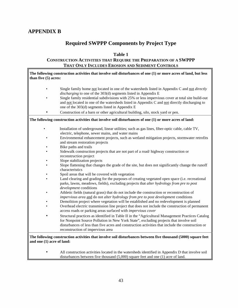
43
APPENDIX B
Required SWPPP Components by Project Type
Table 1 CONSTRUCTION ACTIVITIES THAT REQUIRE THE PREPARATION OF A SWPPP
THAT ONLY INCLUDES EROSION AND SEDIMENT CONTROLS
The following construction activities that involve soil disturbances of one (1) or more acres of land, but less than five (5) acres:
• Single family home not located in one of the watersheds listed in Appendix C and not directly
discharging to one of the 303(d) segments listed in Appendix E • Single family residential subdivisions with 25% or less impervious cover at total site build-out
and not located in one of the watersheds listed in Appendix C and not directly discharging to one of the 303(d) segments listed in Appendix E
• Construction of a barn or other agricultural building, silo, stock yard or pen.
The following construction activities that involve soil disturbances of one (1) or more acres of land:
• Installation of underground, linear utilities; such as gas lines, fiber-optic cable, cable TV, electric, telephone, sewer mains, and water mains
• Environmental enhancement projects, such as wetland mitigation projects, stormwater retrofits and stream restoration projects
• Bike paths and trails • Sidewalk construction projects that are not part of a road/ highway construction or
reconstruction project • Slope stabilization projects • Slope flattening that changes the grade of the site, but does not significantly change the runoff
characteristics • Spoil areas that will be covered with vegetation • Land clearing and grading for the purposes of creating vegetated open space (i.e. recreational
parks, lawns, meadows, fields), excluding projects that alter hydrology from pre to post development conditions
• Athletic fields (natural grass) that do not include the construction or reconstruction of impervious area and do not alter hydrology from pre to post development conditions
• Demolition project where vegetation will be established and no redevelopment is planned • Overhead electric transmission line project that does not include the construction of permanent
access roads or parking areas surfaced with impervious cover • Structural practices as identified in Table II in the “Agricultural Management Practices Catalog
for Nonpoint Source Pollution in New York State”, excluding projects that involve soil disturbances of less than five acres and construction activities that include the construction or reconstruction of impervious area
The following construction activities that involve soil disturbances between five thousand (5000) square feet and one (1) acre of land:
• All construction activities located in the watersheds identified in Appendix D that involve soil disturbances between five thousand (5,000) square feet and one (1) acre of land.
44
Table 2 CONSTRUCTION ACTIVITIES THAT REQUIRE THE PREPARATION OF A SWPPP
THAT INCLUDES POST-CONSTRUCTION STORMWATER MANAGEMENT PRACTICES
The following construction activities that involve soil disturbances of one (1) or more acres of land:
• Single family home located in one of the watersheds listed in Appendix C or directly discharging to one of the 303(d) segments listed in Appendix E
• Single family residential subdivisions located in one of the watersheds listed in Appendix C or directly discharging to one of the 303(d) segments listed in Appendix E
• Single family residential subdivisions that involve soil disturbances of between one (1) and five (5) acres of land with greater than 25% impervious cover at total site build-out
• Single family residential subdivisions that involve soil disturbances of five (5) or more acres of land, and single family residential subdivisions that involve soil disturbances of less than five (5) acres that are part of a larger common plan of development or sale that will ultimately disturb five or more acres of land
• Multi-family residential developments; includes townhomes, condominiums, senior housing complexes, apartment complexes, and mobile home parks
• Airports • Amusement parks • Campgrounds • Cemeteries that include the construction or reconstruction of impervious area (>5% of disturbed
area) or alter the hydrology from pre to post development conditions • Commercial developments • Churches and other places of worship • Construction of a barn or other agricultural building(e.g. silo) and structural practices as
identified in Table II in the “Agricultural Management Practices Catalog for Nonpoint Source Pollution in New York State” that include the construction or reconstruction of impervious area, excluding projects that involve soil disturbances of less than five acres.
• Golf courses • Institutional, includes hospitals, prisons, schools and colleges • Industrial facilities, includes industrial parks • Landfills • Municipal facilities; includes highway garages, transfer stations, office buildings, POTW’s and
water treatment plants • Office complexes • Sports complexes • Racetracks, includes racetracks with earthen (dirt) surface • Road construction or reconstruction • Parking lot construction or reconstruction • Athletic fields (natural grass) that include the construction or reconstruction of impervious area
(>5% of disturbed area) or alter the hydrology from pre to post development conditions • Athletic fields with artificial turf • Permanent access roads, parking areas, substations, compressor stations and well drilling pads,
surfaced with impervious cover, and constructed as part of an over-head electric transmission line project , wind-power project, cell tower project, oil or gas well drilling project, sewer or water main project or other linear utility project
• All other construction activities that include the construction or reconstruction of impervious area or alter the hydrology from pre to post development conditions, and are not listed in Table 1
45
APPENDIX C
Watersheds Where Enhanced Phosphorus Removal Standards Are Required Watersheds where owners or operators of construction activities identified in Table 2 of Appendix B must prepare a SWPPP that includes post-construction stormwater management practices designed in conformance with the Enhanced Phosphorus Removal Standards included in the technical standard, New York State Stormwater Management Design Manual (“Design Manual”).
• Entire New York City Watershed located east of the Hudson River - Figure 1 • Onondaga Lake Watershed - Figure 2 • Greenwood Lake Watershed -Figure 3 • Oscawana Lake Watershed – Figure 4 • Kinderhook Lake Watershed – Figure 5
46
Figure 1 - New York City Watershed East of the Hudson
47
Figure 2 - Onondaga Lake Watershed
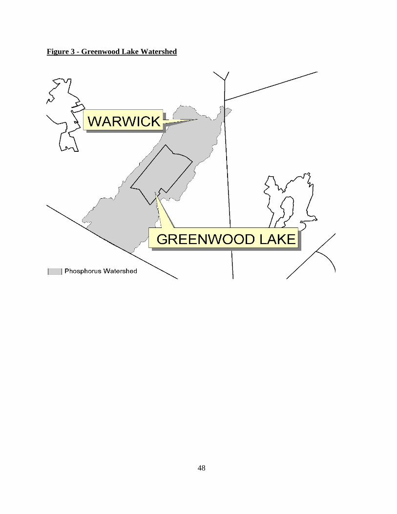
48
Figure 3 - Greenwood Lake Watershed
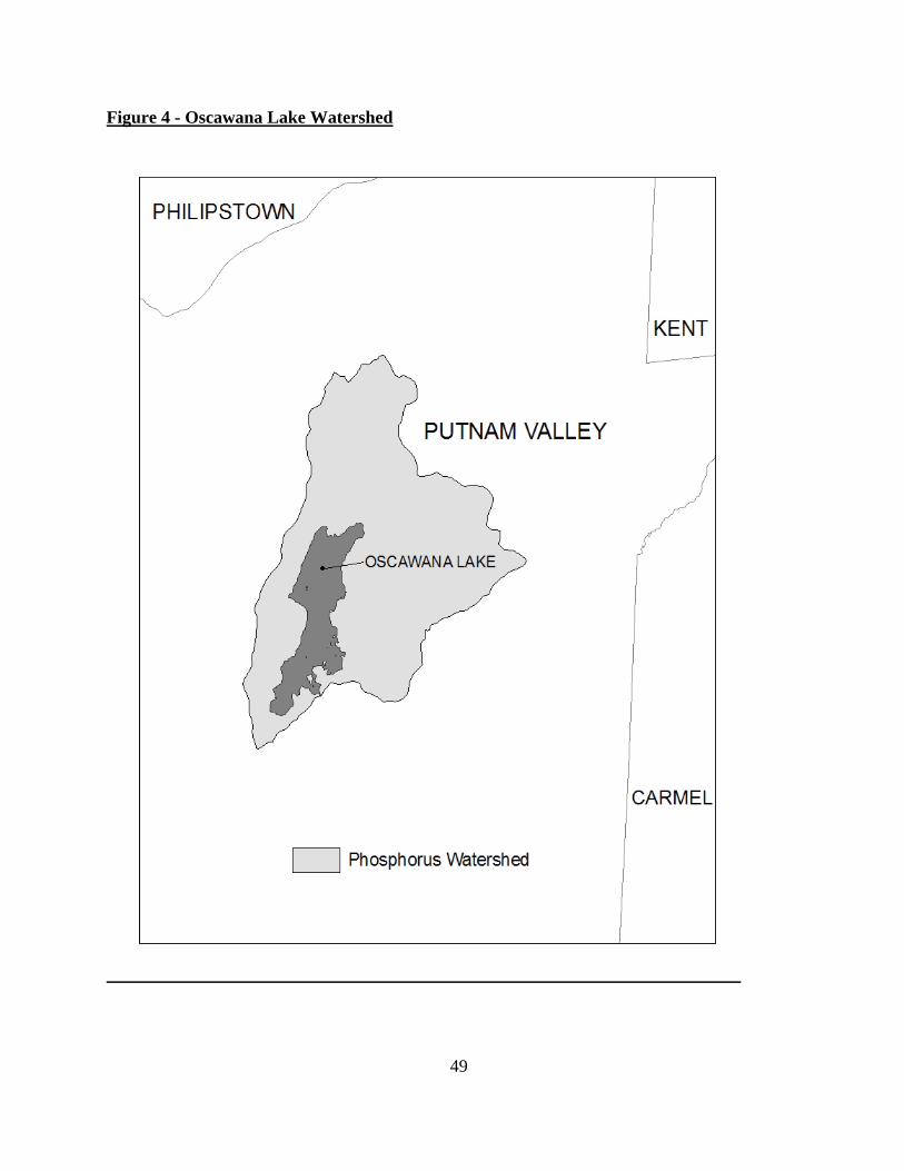
49
Figure 4 - Oscawana Lake Watershed
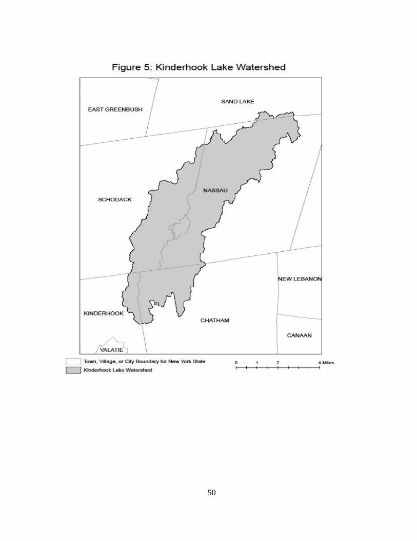
50
51
APPENDIX D Watersheds where owners or operators of construction activities that involve soil disturbances between five thousand (5000) square feet and one (1) acre of land must obtain coverage under this permit.
Entire New York City Watershed that is located east of the Hudson River - See Figure 1 in Appendix C
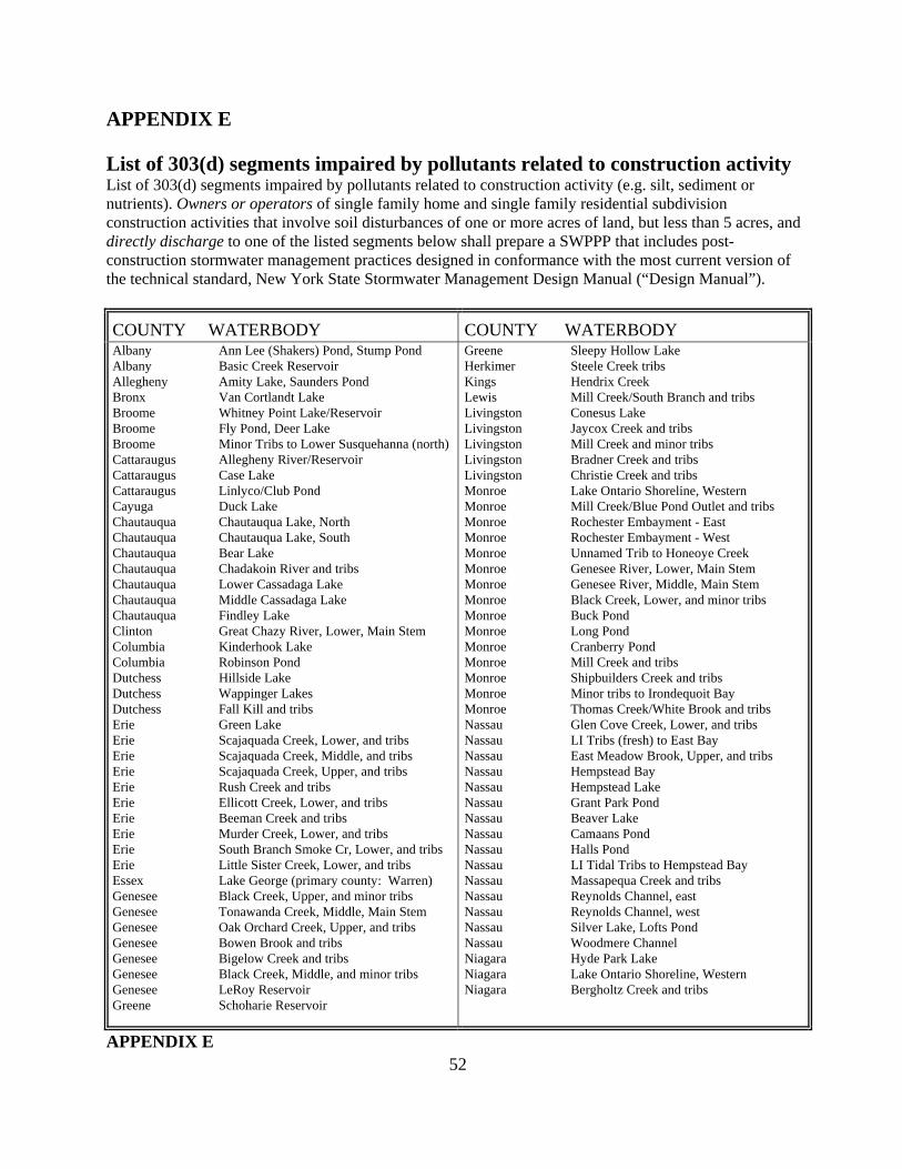
52
APPENDIX E List of 303(d) segments impaired by pollutants related to construction activity List of 303(d) segments impaired by pollutants related to construction activity (e.g. silt, sediment or nutrients). Owners or operators of single family home and single family residential subdivision construction activities that involve soil disturbances of one or more acres of land, but less than 5 acres, and directly discharge to one of the listed segments below shall prepare a SWPPP that includes post-construction stormwater management practices designed in conformance with the most current version of the technical standard, New York State Stormwater Management Design Manual (“Design Manual”).
COUNTY WATERBODY COUNTY WATERBODY Albany Ann Lee (Shakers) Pond, Stump Pond Albany Basic Creek Reservoir Allegheny Amity Lake, Saunders Pond Bronx Van Cortlandt Lake Broome Whitney Point Lake/Reservoir Broome Fly Pond, Deer Lake Broome Minor Tribs to Lower Susquehanna (north) Cattaraugus Allegheny River/Reservoir Cattaraugus Case Lake Cattaraugus Linlyco/Club Pond Cayuga Duck Lake Chautauqua Chautauqua Lake, North Chautauqua Chautauqua Lake, South Chautauqua Bear Lake Chautauqua Chadakoin River and tribs Chautauqua Lower Cassadaga Lake Chautauqua Middle Cassadaga Lake Chautauqua Findley Lake Clinton Great Chazy River, Lower, Main Stem Columbia Kinderhook Lake Columbia Robinson Pond Dutchess Hillside Lake Dutchess Wappinger Lakes Dutchess Fall Kill and tribs Erie Green Lake Erie Scajaquada Creek, Lower, and tribs Erie Scajaquada Creek, Middle, and tribs Erie Scajaquada Creek, Upper, and tribs Erie Rush Creek and tribs Erie Ellicott Creek, Lower, and tribs Erie Beeman Creek and tribs Erie Murder Creek, Lower, and tribs Erie South Branch Smoke Cr, Lower, and tribs Erie Little Sister Creek, Lower, and tribs Essex Lake George (primary county: Warren) Genesee Black Creek, Upper, and minor tribs Genesee Tonawanda Creek, Middle, Main Stem Genesee Oak Orchard Creek, Upper, and tribs Genesee Bowen Brook and tribs Genesee Bigelow Creek and tribs Genesee Black Creek, Middle, and minor tribs Genesee LeRoy Reservoir Greene Schoharie Reservoir
Greene Sleepy Hollow Lake Herkimer Steele Creek tribs Kings Hendrix Creek Lewis Mill Creek/South Branch and tribs Livingston Conesus Lake Livingston Jaycox Creek and tribs Livingston Mill Creek and minor tribs Livingston Bradner Creek and tribs Livingston Christie Creek and tribs Monroe Lake Ontario Shoreline, Western Monroe Mill Creek/Blue Pond Outlet and tribs Monroe Rochester Embayment - East Monroe Rochester Embayment - West Monroe Unnamed Trib to Honeoye Creek Monroe Genesee River, Lower, Main Stem Monroe Genesee River, Middle, Main Stem Monroe Black Creek, Lower, and minor tribs Monroe Buck Pond Monroe Long Pond Monroe Cranberry Pond Monroe Mill Creek and tribs Monroe Shipbuilders Creek and tribs Monroe Minor tribs to Irondequoit Bay Monroe Thomas Creek/White Brook and tribs Nassau Glen Cove Creek, Lower, and tribs Nassau LI Tribs (fresh) to East Bay Nassau East Meadow Brook, Upper, and tribs Nassau Hempstead Bay Nassau Hempstead Lake Nassau Grant Park Pond Nassau Beaver Lake Nassau Camaans Pond Nassau Halls Pond Nassau LI Tidal Tribs to Hempstead Bay Nassau Massapequa Creek and tribs Nassau Reynolds Channel, east Nassau Reynolds Channel, west Nassau Silver Lake, Lofts Pond Nassau Woodmere Channel Niagara Hyde Park Lake Niagara Lake Ontario Shoreline, Western Niagara Bergholtz Creek and tribs
APPENDIX E
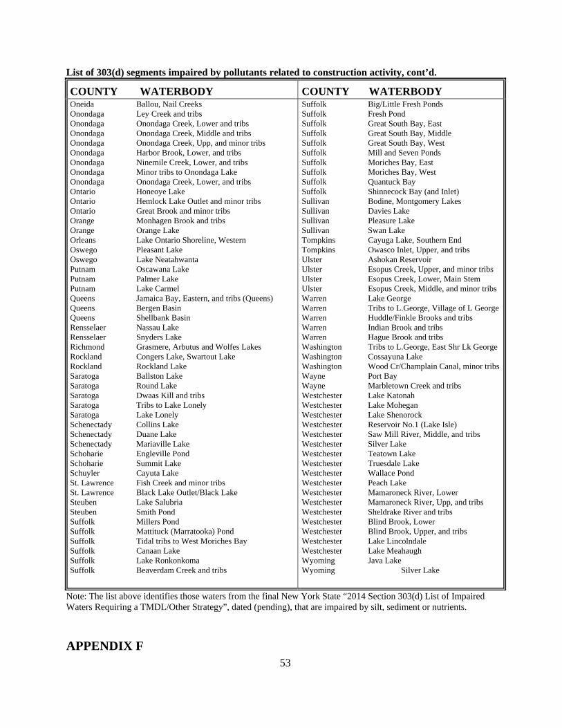
53
List of 303(d) segments impaired by pollutants related to construction activity, cont’d.
COUNTY WATERBODY COUNTY WATERBODY Oneida Ballou, Nail Creeks Onondaga Ley Creek and tribs Onondaga Onondaga Creek, Lower and tribs Onondaga Onondaga Creek, Middle and tribs Onondaga Onondaga Creek, Upp, and minor tribs Onondaga Harbor Brook, Lower, and tribs Onondaga Ninemile Creek, Lower, and tribs Onondaga Minor tribs to Onondaga Lake Onondaga Onondaga Creek, Lower, and tribs Ontario Honeoye Lake Ontario Hemlock Lake Outlet and minor tribs Ontario Great Brook and minor tribs Orange Monhagen Brook and tribs Orange Orange Lake Orleans Lake Ontario Shoreline, Western Oswego Pleasant Lake Oswego Lake Neatahwanta Putnam Oscawana Lake Putnam Palmer Lake Putnam Lake Carmel Queens Jamaica Bay, Eastern, and tribs (Queens) Queens Bergen Basin Queens Shellbank Basin Rensselaer Nassau Lake Rensselaer Snyders Lake Richmond Grasmere, Arbutus and Wolfes Lakes Rockland Congers Lake, Swartout Lake Rockland Rockland Lake Saratoga Ballston Lake Saratoga Round Lake Saratoga Dwaas Kill and tribs Saratoga Tribs to Lake Lonely Saratoga Lake Lonely Schenectady Collins Lake Schenectady Duane Lake Schenectady Mariaville Lake Schoharie Engleville Pond Schoharie Summit Lake Schuyler Cayuta Lake St. Lawrence Fish Creek and minor tribs St. Lawrence Black Lake Outlet/Black Lake Steuben Lake Salubria Steuben Smith Pond Suffolk Millers Pond Suffolk Mattituck (Marratooka) Pond Suffolk Tidal tribs to West Moriches Bay Suffolk Canaan Lake Suffolk Lake Ronkonkoma Suffolk Beaverdam Creek and tribs
Suffolk Big/Little Fresh Ponds Suffolk Fresh Pond Suffolk Great South Bay, East Suffolk Great South Bay, Middle Suffolk Great South Bay, West Suffolk Mill and Seven Ponds Suffolk Moriches Bay, East Suffolk Moriches Bay, West Suffolk Quantuck Bay Suffolk Shinnecock Bay (and Inlet) Sullivan Bodine, Montgomery Lakes Sullivan Davies Lake Sullivan Pleasure Lake Sullivan Swan Lake Tompkins Cayuga Lake, Southern End Tompkins Owasco Inlet, Upper, and tribs Ulster Ashokan Reservoir Ulster Esopus Creek, Upper, and minor tribs Ulster Esopus Creek, Lower, Main Stem Ulster Esopus Creek, Middle, and minor tribs Warren Lake George Warren Tribs to L.George, Village of L George Warren Huddle/Finkle Brooks and tribs Warren Indian Brook and tribs Warren Hague Brook and tribs Washington Tribs to L.George, East Shr Lk George Washington Cossayuna Lake Washington Wood Cr/Champlain Canal, minor tribs Wayne Port Bay Wayne Marbletown Creek and tribs Westchester Lake Katonah Westchester Lake Mohegan Westchester Lake Shenorock Westchester Reservoir No.1 (Lake Isle) Westchester Saw Mill River, Middle, and tribs Westchester Silver Lake Westchester Teatown Lake Westchester Truesdale Lake Westchester Wallace Pond Westchester Peach Lake Westchester Mamaroneck River, Lower Westchester Mamaroneck River, Upp, and tribs Westchester Sheldrake River and tribs Westchester Blind Brook, Lower Westchester Blind Brook, Upper, and tribs Westchester Lake Lincolndale Westchester Lake Meahaugh Wyoming Java Lake Wyoming Silver Lake
Note: The list above identifies those waters from the final New York State “2014 Section 303(d) List of Impaired Waters Requiring a TMDL/Other Strategy”, dated (pending), that are impaired by silt, sediment or nutrients.
APPENDIX F
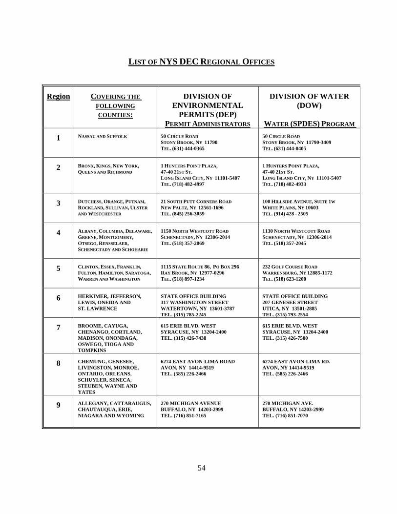
54
LIST OF NYS DEC REGIONAL OFFICES
Region COVERING THE
FOLLOWING COUNTIES:
DIVISION OF
ENVIRONMENTAL PERMITS (DEP)
PERMIT ADMINISTRATORS
DIVISION OF WATER
(DOW) WATER (SPDES) PROGRAM
1 NASSAU AND SUFFOLK 50 CIRCLE ROAD STONY BROOK, NY 11790 TEL. (631) 444-0365
50 CIRCLE ROAD STONY BROOK, NY 11790-3409 TEL. (631) 444-0405
2 BRONX, KINGS, NEW YORK, QUEENS AND RICHMOND
1 HUNTERS POINT PLAZA, 47-40 21ST ST. LONG ISLAND CITY, NY 11101-5407 TEL. (718) 482-4997
1 HUNTERS POINT PLAZA, 47-40 21ST ST. LONG ISLAND CITY, NY 11101-5407 TEL. (718) 482-4933
3 DUTCHESS, ORANGE, PUTNAM, ROCKLAND, SULLIVAN, ULSTER
AND WESTCHESTER
21 SOUTH PUTT CORNERS ROAD NEW PALTZ, NY 12561-1696 TEL. (845) 256-3059
100 HILLSIDE AVENUE, SUITE 1W WHITE PLAINS, NY 10603 TEL. (914) 428 - 2505
4 ALBANY, COLUMBIA, DELAWARE, GREENE, MONTGOMERY, OTSEGO, RENSSELAER, SCHENECTADY AND SCHOHARIE
1150 NORTH WESTCOTT ROAD SCHENECTADY, NY 12306-2014 TEL. (518) 357-2069
1130 NORTH WESTCOTT ROAD SCHENECTADY, NY 12306-2014 TEL. (518) 357-2045
5 CLINTON, ESSEX, FRANKLIN, FULTON, HAMILTON, SARATOGA, WARREN AND WASHINGTON
1115 STATE ROUTE 86, PO BOX 296 RAY BROOK, NY 12977-0296 TEL. (518) 897-1234
232 GOLF COURSE ROAD WARRENSBURG, NY 12885-1172 TEL. (518) 623-1200
6 HERKIMER, JEFFERSON, LEWIS, ONEIDA AND ST. LAWRENCE
STATE OFFICE BUILDING 317 WASHINGTON STREET WATERTOWN, NY 13601-3787 TEL. (315) 785-2245
STATE OFFICE BUILDING 207 GENESEE STREET UTICA, NY 13501-2885 TEL. (315) 793-2554
7 BROOME, CAYUGA, CHENANGO, CORTLAND, MADISON, ONONDAGA, OSWEGO, TIOGA AND TOMPKINS
615 ERIE BLVD. WEST SYRACUSE, NY 13204-2400 TEL. (315) 426-7438
615 ERIE BLVD. WEST SYRACUSE, NY 13204-2400 TEL. (315) 426-7500
8 CHEMUNG, GENESEE, LIVINGSTON, MONROE, ONTARIO, ORLEANS, SCHUYLER, SENECA, STEUBEN, WAYNE AND YATES
6274 EAST AVON-LIMA ROAD AVON, NY 14414-9519 TEL. (585) 226-2466
6274 EAST AVON-LIMA RD. AVON, NY 14414-9519 TEL. (585) 226-2466
9 ALLEGANY, CATTARAUGUS, CHAUTAUQUA, ERIE, NIAGARA AND WYOMING
270 MICHIGAN AVENUE BUFFALO, NY 14203-2999 TEL. (716) 851-7165
270 MICHIGAN AVE. BUFFALO, NY 14203-2999 TEL. (716) 851-7070
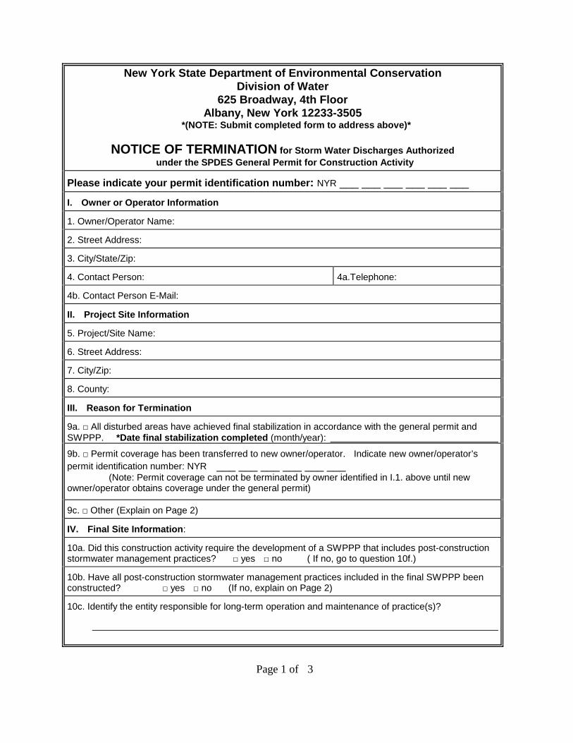
New York State Department of Environmental Conservation Division of Water
625 Broadway, 4th Floor Albany, New York 12233-3505
*(NOTE: Submit completed form to address above)*
NOTICE OF TERMINATION for Storm Water Discharges Authorized under the SPDES General Permit for Construction Activity
Please indicate your permit identification number: NYR ___ ___ ___ ___ ___ ___
I. Owner or Operator Information
1. Owner/Operator Name:
2. Street Address:
3. City/State/Zip:
4. Contact Person: 4a.Telephone:
4b. Contact Person E-Mail:
II. Project Site Information
5. Project/Site Name:
6. Street Address:
7. City/Zip:
8. County:
III. Reason for Termination
9a. □ All disturbed areas have achieved final stabilization in accordance with the general permit and SWPPP. *Date final stabilization completed (month/year):
9b. □ Permit coverage has been transferred to new owner/operator. Indicate new owner/operator’s permit identification number: NYR ___ ___ ___ ___ ___ ___ (Note: Permit coverage can not be terminated by owner identified in I.1. above until new owner/operator obtains coverage under the general permit)
9c. □ Other (Explain on Page 2)
IV. Final Site Information:
10a. Did this construction activity require the development of a SWPPP that includes post-construction stormwater management practices? □ yes □ no ( If no, go to question 10f.)
10b. Have all post-construction stormwater management practices included in the final SWPPP been constructed? □ yes □ no (If no, explain on Page 2)
10c. Identify the entity responsible for long-term operation and maintenance of practice(s)?
Page 1 of 3
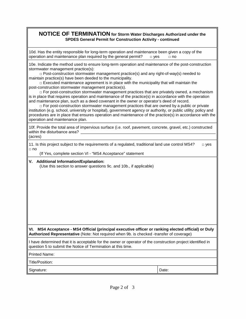
NOTICE OF TERMINATION for Storm Water Discharges Authorized under the SPDES General Permit for Construction Activity - continued
10d. Has the entity responsible for long-term operation and maintenance been given a copy of the operation and maintenance plan required by the general permit? □ yes □ no
10e. Indicate the method used to ensure long-term operation and maintenance of the post-construction stormwater management practice(s): □ Post-construction stormwater management practice(s) and any right-of-way(s) needed to maintain practice(s) have been deeded to the municipality. □ Executed maintenance agreement is in place with the municipality that will maintain the post-construction stormwater management practice(s). □ For post-construction stormwater management practices that are privately owned, a mechanism is in place that requires operation and maintenance of the practice(s) in accordance with the operation and maintenance plan, such as a deed covenant in the owner or operator’s deed of record. □ For post-construction stormwater management practices that are owned by a public or private institution (e.g. school, university or hospital), government agency or authority, or public utility; policy and procedures are in place that ensures operation and maintenance of the practice(s) in accordance with the operation and maintenance plan.
10f. Provide the total area of impervious surface (i.e. roof, pavement, concrete, gravel, etc.) constructed within the disturbance area? (acres)
11. Is this project subject to the requirements of a regulated, traditional land use control MS4? □ yes □ no (If Yes, complete section VI - “MS4 Acceptance” statement
V. Additional Information/Explanation: (Use this section to answer questions 9c. and 10b., if applicable)
VI. MS4 Acceptance - MS4 Official (principal executive officer or ranking elected official) or Duly Authorized Representative (Note: Not required when 9b. is checked -transfer of coverage)
I have determined that it is acceptable for the owner or operator of the construction project identified in question 5 to submit the Notice of Termination at this time.
Printed Name:
Title/Position:
Signature: Date:
Page 2 of 3
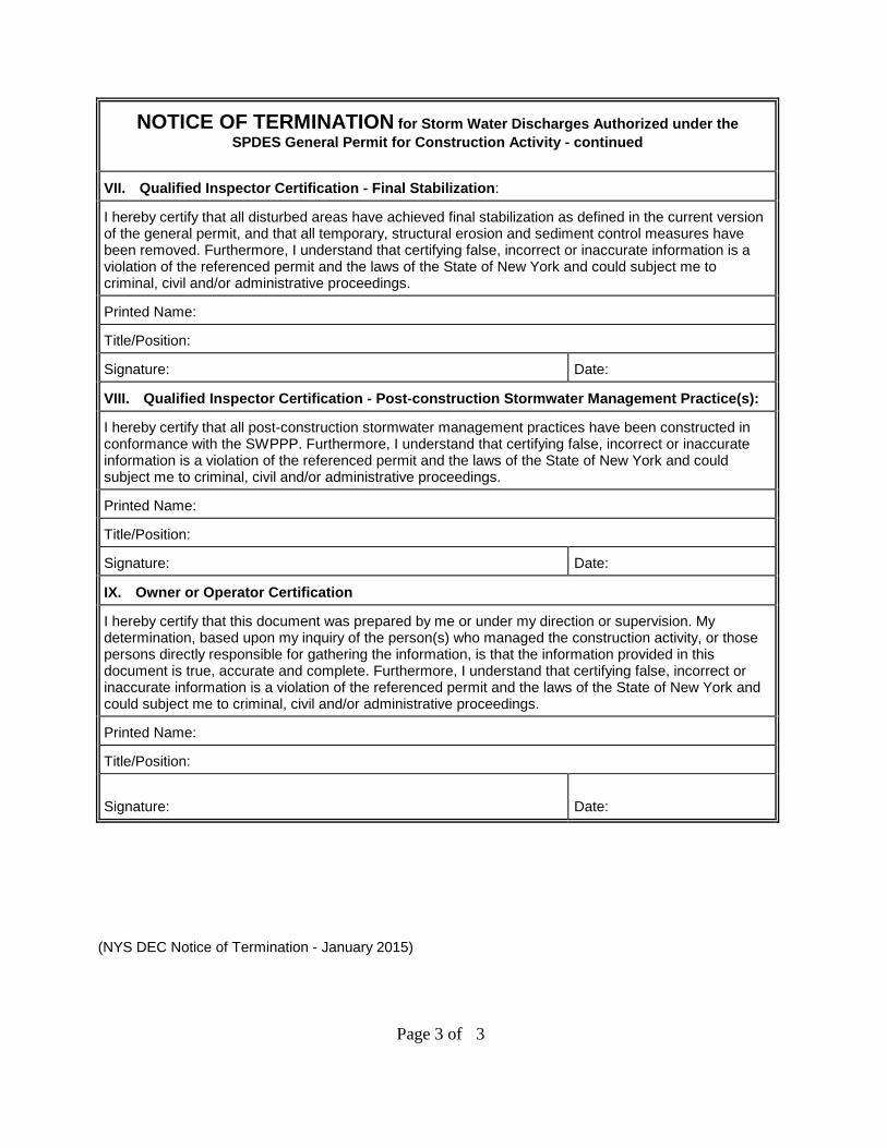
NOTICE OF TERMINATION for Storm Water Discharges Authorized under the SPDES General Permit for Construction Activity - continued
VII. Qualified Inspector Certification - Final Stabilization:
I hereby certify that all disturbed areas have achieved final stabilization as defined in the current version of the general permit, and that all temporary, structural erosion and sediment control measures have been removed. Furthermore, I understand that certifying false, incorrect or inaccurate information is a violation of the referenced permit and the laws of the State of New York and could subject me to criminal, civil and/or administrative proceedings.
Printed Name:
Title/Position:
Signature: Date:
VIII. Qualified Inspector Certification - Post-construction Stormwater Management Practice(s):
I hereby certify that all post-construction stormwater management practices have been constructed in conformance with the SWPPP. Furthermore, I understand that certifying false, incorrect or inaccurate information is a violation of the referenced permit and the laws of the State of New York and could subject me to criminal, civil and/or administrative proceedings.
Printed Name:
Title/Position:
Signature: Date:
IX. Owner or Operator Certification
I hereby certify that this document was prepared by me or under my direction or supervision. My determination, based upon my inquiry of the person(s) who managed the construction activity, or those persons directly responsible for gathering the information, is that the information provided in this document is true, accurate and complete. Furthermore, I understand that certifying false, incorrect or inaccurate information is a violation of the referenced permit and the laws of the State of New York and could subject me to criminal, civil and/or administrative proceedings.
Printed Name:
Title/Position:
Signature:
Date:
(NYS DEC Notice of Termination - January 2015)
Page 3 of 3
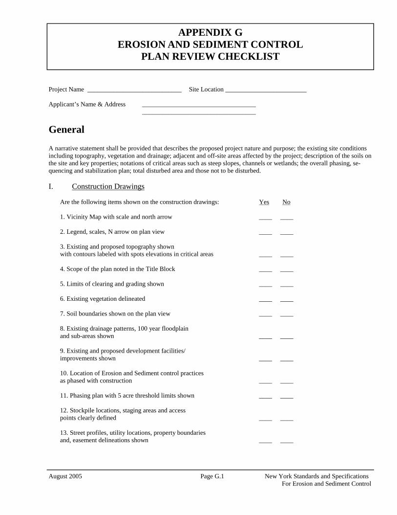
August 2005 Page G.1 New York Standards and Specifications For Erosion and Sediment Control
Project Name _____________________________ Site Location _________________________ Applicant’s Name & Address ___________________________________ ___________________________________
General A narrative statement shall be provided that describes the proposed project nature and purpose; the existing site conditions including topography, vegetation and drainage; adjacent and off-site areas affected by the project; description of the soils on the site and key properties; notations of critical areas such as steep slopes, channels or wetlands; the overall phasing, se-quencing and stabilization plan; total disturbed area and those not to be disturbed. I. Construction Drawings
Are the following items shown on the construction drawings: Yes No 1. Vicinity Map with scale and north arrow ____ ____ 2. Legend, scales, N arrow on plan view ____ ____ 3. Existing and proposed topography shown with contours labeled with spots elevations in critical areas ____ ____ 4. Scope of the plan noted in the Title Block ____ ____ 5. Limits of clearing and grading shown ____ ____ 6. Existing vegetation delineated ____ ____ 7. Soil boundaries shown on the plan view ____ ____ 8. Existing drainage patterns, 100 year floodplain and sub-areas shown ____ ____ 9. Existing and proposed development facilities/ improvements shown ____ ____ 10. Location of Erosion and Sediment control practices as phased with construction ____ ____ 11. Phasing plan with 5 acre threshold limits shown ____ ____ 12. Stockpile locations, staging areas and access points clearly defined ____ ____ 13. Street profiles, utility locations, property boundaries and, easement delineations shown ____ ____
APPENDIX G EROSION AND SEDIMENT CONTROL
PLAN REVIEW CHECKLIST
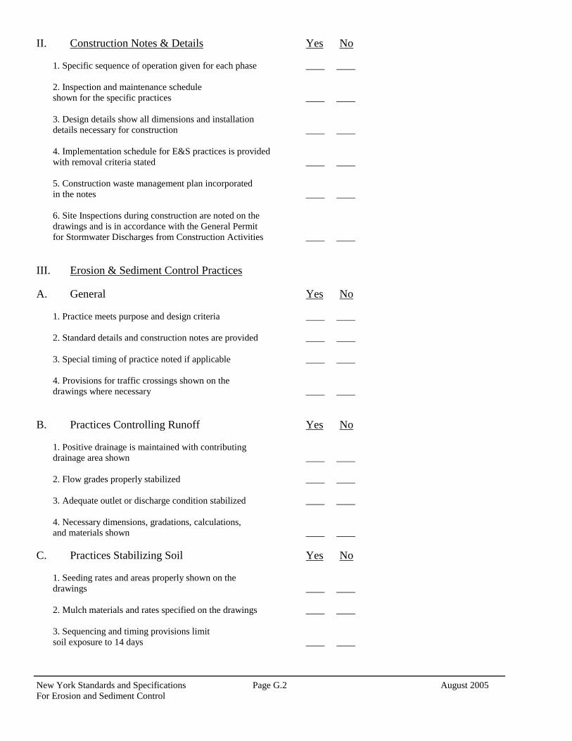
New York Standards and Specifications Page G.2 August 2005 For Erosion and Sediment Control
II. Construction Notes & Details Yes No 1. Specific sequence of operation given for each phase ____ ____ 2. Inspection and maintenance schedule shown for the specific practices ____ ____ 3. Design details show all dimensions and installation details necessary for construction ____ ____ 4. Implementation schedule for E&S practices is provided with removal criteria stated ____ ____ 5. Construction waste management plan incorporated in the notes ____ ____ 6. Site Inspections during construction are noted on the drawings and is in accordance with the General Permit for Stormwater Discharges from Construction Activities ____ ____
III. Erosion & Sediment Control Practices A. General Yes No
1. Practice meets purpose and design criteria ____ ____ 2. Standard details and construction notes are provided ____ ____ 3. Special timing of practice noted if applicable ____ ____ 4. Provisions for traffic crossings shown on the drawings where necessary ____ ____
B. Practices Controlling Runoff Yes No
1. Positive drainage is maintained with contributing drainage area shown ____ ____ 2. Flow grades properly stabilized ____ ____ 3. Adequate outlet or discharge condition stabilized ____ ____ 4. Necessary dimensions, gradations, calculations, and materials shown ____ ____
C. Practices Stabilizing Soil Yes No
1. Seeding rates and areas properly shown on the drawings ____ ____ 2. Mulch materials and rates specified on the drawings ____ ____ 3. Sequencing and timing provisions limit soil exposure to 14 days ____ ____
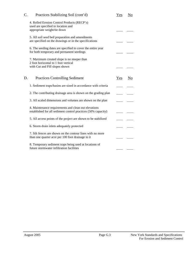
August 2005 Page G.3 New York Standards and Specifications For Erosion and Sediment Control
C. Practices Stabilizing Soil (cont’d) Yes No 4. Rolled Erosion Control Products (RECP’s) used are specified to location and appropriate weight/tie down ____ ____ 5. All soil seed bed preparation and amendments are specified on the drawings or in the specifications ____ ____ 6. The seeding dates are specified to cover the entire year for both temporary and permanent seedings ____ ____ 7. Maximum created slope is no steeper than 2 foot horizontal to 1 foot vertical with Cut and Fill slopes shown ____ ____
D. Practices Controlling Sediment Yes No
1. Sediment traps/basins are sized in accordance with criteria ____ ____ 2. The contributing drainage area is shown on the grading plan ____ ____ 3. All scaled dimensions and volumes are shown on the plan ____ ____ 4. Maintenance requirements and clean out elevations established for all sediment control practices (50% capacity) ____ ____ 5. All access points of the project are shown to be stabilized ____ ____ 6. Storm drain inlets adequately protected ____ ____ 7. Silt fences are shown on the contour lines with no more than one quarter acre per 100 foot drainage to it ____ ____ 8. Temporary sediment traps being used at locations of future stormwater infiltration facilities ____ ____

New York Standards and Specifications Page G.4 August 2005 For Erosion and Sediment Control
Additional Comments Plan Reviewed By: _____________________________________ Date: ______________
August 2005 Page H.1 New York Standards and Specifications For Erosion and Sediment Control
STATE POLLUTANT DISCHARGE ELIMINATION SYSTEM FOR CONSTRUCTION ACTIVITIES
CONSTRUCTION SITE LOG BOOK
Table of Contents I. Pre-Construction Meeting Documents a. Preamble to Site Assessment and Inspections b. Operator’s Certification c. Qualified Professional's Credentials & Certification d. Pre-Construction Site Assessment Checklist II. Construction Duration Inspections a. Directions b. Modification to the SWPPP III. Monthly Summary Reports IV. Monitoring, Reporting, and Three-Month Status Reports a. Operator’s Compliance Response Form
APPENDIX H
Properly completing forms such as those contained in Appendix H meet the inspection requirement of NYS-DEC SPDES GP for Construction Activities. Completed forms shall be kept on site at all times and made avail-able to authorities upon request.
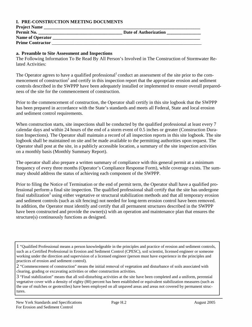
New York Standards and Specifications Page H.2 August 2005 For Erosion and Sediment Control
I. PRE-CONSTRUCTION MEETING DOCUMENTS Project Name _____________________________________________________________________ Permit No. _____________________________________ Date of Authorization _______________ Name of Operator _________________________________________________________________ Prime Contractor __________________________________________________________________ a. Preamble to Site Assessment and Inspections The Following Information To Be Read By All Person’s Involved in The Construction of Stormwater Re-lated Activities: The Operator agrees to have a qualified professional1 conduct an assessment of the site prior to the com-mencement of construction2 and certify in this inspection report that the appropriate erosion and sediment controls described in the SWPPP have been adequately installed or implemented to ensure overall prepared-ness of the site for the commencement of construction. Prior to the commencement of construction, the Operator shall certify in this site logbook that the SWPPP has been prepared in accordance with the State’s standards and meets all Federal, State and local erosion and sediment control requirements. When construction starts, site inspections shall be conducted by the qualified professional at least every 7 calendar days and within 24 hours of the end of a storm event of 0.5 inches or greater (Construction Dura-tion Inspections). The Operator shall maintain a record of all inspection reports in this site logbook. The site logbook shall be maintained on site and be made available to the permitting authorities upon request. The Operator shall post at the site, in a publicly accessible location, a summary of the site inspection activities on a monthly basis (Monthly Summary Report). The operator shall also prepare a written summary of compliance with this general permit at a minimum frequency of every three months (Operator’s Compliance Response Form), while coverage exists. The sum-mary should address the status of achieving each component of the SWPPP. Prior to filing the Notice of Termination or the end of permit term, the Operator shall have a qualified pro-fessional perform a final site inspection. The qualified professional shall certify that the site has undergone final stabilization3 using either vegetative or structural stabilization methods and that all temporary erosion and sediment controls (such as silt fencing) not needed for long-term erosion control have been removed. In addition, the Operator must identify and certify that all permanent structures described in the SWPPP have been constructed and provide the owner(s) with an operation and maintenance plan that ensures the structure(s) continuously functions as designed.
1 “Qualified Professional means a person knowledgeable in the principles and practice of erosion and sediment controls, such as a Certified Professional in Erosion and Sediment Control (CPESC), soil scientist, licensed engineer or someone working under the direction and supervision of a licensed engineer (person must have experience in the principles and practices of erosion and sediment control). 2 “Commencement of construction” means the initial removal of vegetation and disturbance of soils associated with clearing, grading or excavating activities or other construction activities. 3 “Final stabilization” means that all soil-disturbing activities at the site have been completed and a uniform, perennial vegetative cover with a density of eighty (80) percent has been established or equivalent stabilization measures (such as the use of mulches or geotextiles) have been employed on all unpaved areas and areas not covered by permanent struc-tures.
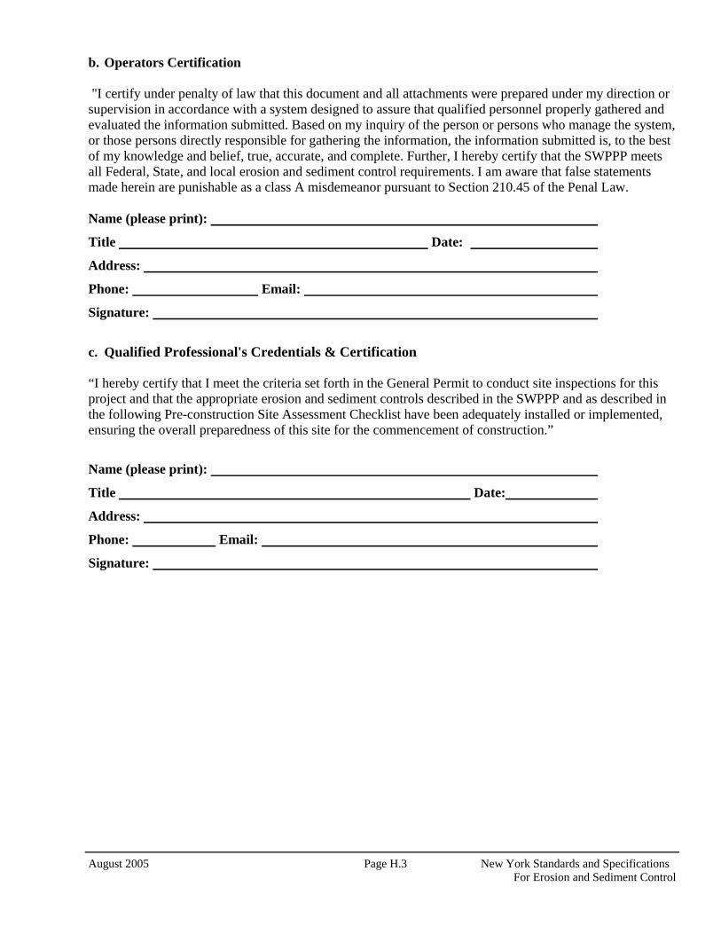
August 2005 Page H.3 New York Standards and Specifications For Erosion and Sediment Control
b. Operators Certification
"I certify under penalty of law that this document and all attachments were prepared under my direction or supervision in accordance with a system designed to assure that qualified personnel properly gathered and evaluated the information submitted. Based on my inquiry of the person or persons who manage the system, or those persons directly responsible for gathering the information, the information submitted is, to the best of my knowledge and belief, true, accurate, and complete. Further, I hereby certify that the SWPPP meets all Federal, State, and local erosion and sediment control requirements. I am aware that false statements made herein are punishable as a class A misdemeanor pursuant to Section 210.45 of the Penal Law. Name (please print):
Title Date:
Address:
Phone: Email:
Signature:
c. Qualified Professional's Credentials & Certification “I hereby certify that I meet the criteria set forth in the General Permit to conduct site inspections for this project and that the appropriate erosion and sediment controls described in the SWPPP and as described in the following Pre-construction Site Assessment Checklist have been adequately installed or implemented, ensuring the overall preparedness of this site for the commencement of construction.”
Name (please print):
Title Date:
Address:
Phone: Email:
Signature:
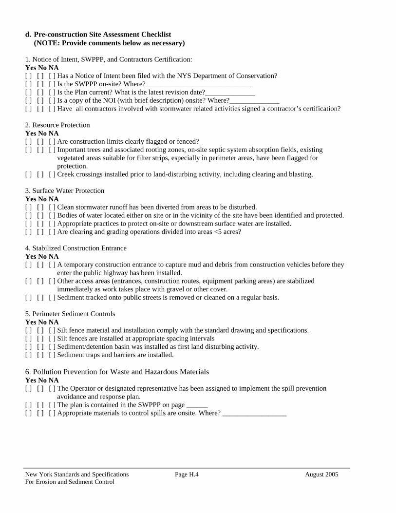
New York Standards and Specifications Page H.4 August 2005 For Erosion and Sediment Control
d. Pre-construction Site Assessment Checklist (NOTE: Provide comments below as necessary) 1. Notice of Intent, SWPPP, and Contractors Certification: Yes No NA [ ] [ ] [ ] Has a Notice of Intent been filed with the NYS Department of Conservation? [ ] [ ] [ ] Is the SWPPP on-site? Where?______________________________ [ ] [ ] [ ] Is the Plan current? What is the latest revision date?______________ [ ] [ ] [ ] Is a copy of the NOI (with brief description) onsite? Where?______________ [ ] [ ] [ ] Have all contractors involved with stormwater related activities signed a contractor’s certification? 2. Resource Protection Yes No NA [ ] [ ] [ ] Are construction limits clearly flagged or fenced? [ ] [ ] [ ] Important trees and associated rooting zones, on-site septic system absorption fields, existing
vegetated areas suitable for filter strips, especially in perimeter areas, have been flagged for protection.
[ ] [ ] [ ] Creek crossings installed prior to land-disturbing activity, including clearing and blasting. 3. Surface Water Protection Yes No NA [ ] [ ] [ ] Clean stormwater runoff has been diverted from areas to be disturbed. [ ] [ ] [ ] Bodies of water located either on site or in the vicinity of the site have been identified and protected. [ ] [ ] [ ] Appropriate practices to protect on-site or downstream surface water are installed. [ ] [ ] [ ] Are clearing and grading operations divided into areas <5 acres? 4. Stabilized Construction Entrance Yes No NA [ ] [ ] [ ] A temporary construction entrance to capture mud and debris from construction vehicles before they
enter the public highway has been installed. [ ] [ ] [ ] Other access areas (entrances, construction routes, equipment parking areas) are stabilized
immediately as work takes place with gravel or other cover. [ ] [ ] [ ] Sediment tracked onto public streets is removed or cleaned on a regular basis. 5. Perimeter Sediment Controls Yes No NA [ ] [ ] [ ] Silt fence material and installation comply with the standard drawing and specifications. [ ] [ ] [ ] Silt fences are installed at appropriate spacing intervals [ ] [ ] [ ] Sediment/detention basin was installed as first land disturbing activity. [ ] [ ] [ ] Sediment traps and barriers are installed. 6. Pollution Prevention for Waste and Hazardous Materials Yes No NA [ ] [ ] [ ] The Operator or designated representative has been assigned to implement the spill prevention
avoidance and response plan. [ ] [ ] [ ] The plan is contained in the SWPPP on page ______ [ ] [ ] [ ] Appropriate materials to control spills are onsite. Where? __________________
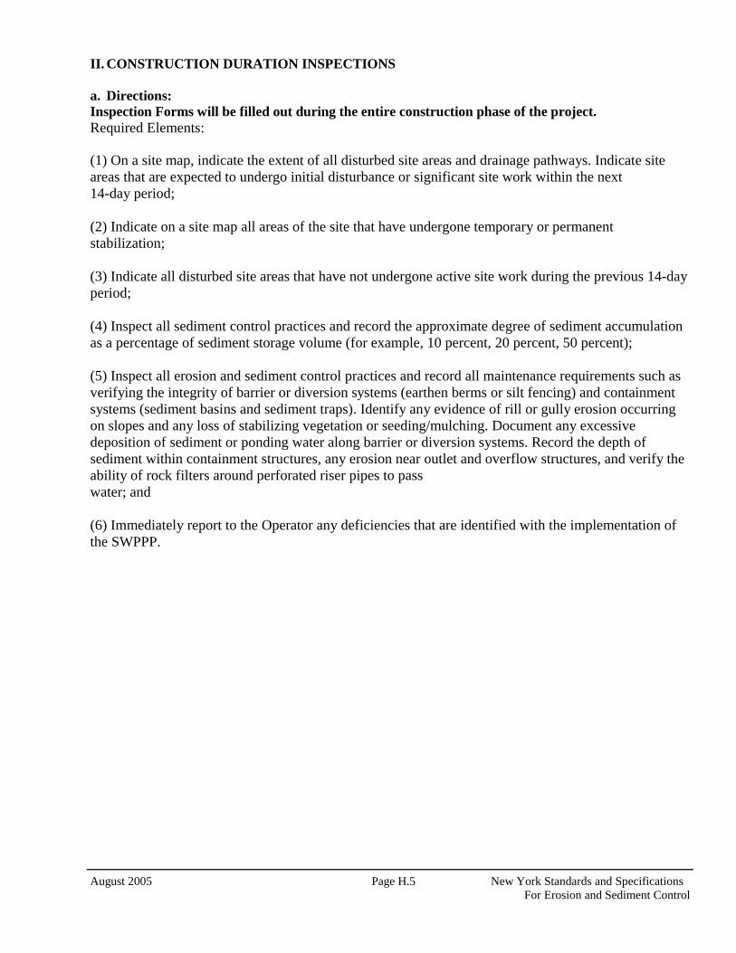
August 2005 Page H.5 New York Standards and Specifications For Erosion and Sediment Control
II. CONSTRUCTION DURATION INSPECTIONS a. Directions: Inspection Forms will be filled out during the entire construction phase of the project. Required Elements: (1) On a site map, indicate the extent of all disturbed site areas and drainage pathways. Indicate site areas that are expected to undergo initial disturbance or significant site work within the next 14-day period; (2) Indicate on a site map all areas of the site that have undergone temporary or permanent stabilization; (3) Indicate all disturbed site areas that have not undergone active site work during the previous 14-day period; (4) Inspect all sediment control practices and record the approximate degree of sediment accumulation as a percentage of sediment storage volume (for example, 10 percent, 20 percent, 50 percent); (5) Inspect all erosion and sediment control practices and record all maintenance requirements such as verifying the integrity of barrier or diversion systems (earthen berms or silt fencing) and containment systems (sediment basins and sediment traps). Identify any evidence of rill or gully erosion occurring on slopes and any loss of stabilizing vegetation or seeding/mulching. Document any excessive deposition of sediment or ponding water along barrier or diversion systems. Record the depth of sediment within containment structures, any erosion near outlet and overflow structures, and verify the ability of rock filters around perforated riser pipes to pass water; and (6) Immediately report to the Operator any deficiencies that are identified with the implementation of the SWPPP.
New York Standards and Specifications Page H.6 August 2005 For Erosion and Sediment Control
CONSTRUCTION DURATION INSPECTIONS Page 1 of ______
SITE PLAN/SKETCH _________________________________________ ____________________________________ Inspector (print name) Date of Inspection ________________________________________ ____________________________________ Qualified Professional (print name) Qualified Professional Signature The above signed acknowledges that, to the best of his/her knowledge, all information provided on the forms is accurate and complete.
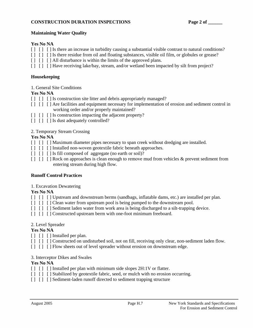
August 2005 Page H.7 New York Standards and Specifications For Erosion and Sediment Control
CONSTRUCTION DURATION INSPECTIONS Page 2 of ______ Maintaining Water Quality Yes No NA [ ] [ ] [ ] Is there an increase in turbidity causing a substantial visible contrast to natural conditions? [ ] [ ] [ ] Is there residue from oil and floating substances, visible oil film, or globules or grease? [ ] [ ] [ ] All disturbance is within the limits of the approved plans. [ ] [ ] [ ] Have receiving lake/bay, stream, and/or wetland been impacted by silt from project? Housekeeping
1. General Site Conditions Yes No NA [ ] [ ] [ ] Is construction site litter and debris appropriately managed? [ ] [ ] [ ] Are facilities and equipment necessary for implementation of erosion and sediment control in
working order and/or properly maintained? [ ] [ ] [ ] Is construction impacting the adjacent property? [ ] [ ] [ ] Is dust adequately controlled? 2. Temporary Stream Crossing Yes No NA [ ] [ ] [ ] Maximum diameter pipes necessary to span creek without dredging are installed. [ ] [ ] [ ] Installed non-woven geotextile fabric beneath approaches. [ ] [ ] [ ] Is fill composed of aggregate (no earth or soil)? [ ] [ ] [ ] Rock on approaches is clean enough to remove mud from vehicles & prevent sediment from
entering stream during high flow. Runoff Control Practices
1. Excavation Dewatering Yes No NA [ ] [ ] [ ] Upstream and downstream berms (sandbags, inflatable dams, etc.) are installed per plan. [ ] [ ] [ ] Clean water from upstream pool is being pumped to the downstream pool. [ ] [ ] [ ] Sediment laden water from work area is being discharged to a silt-trapping device. [ ] [ ] [ ] Constructed upstream berm with one-foot minimum freeboard. 2. Level Spreader Yes No NA [ ] [ ] [ ] Installed per plan. [ ] [ ] [ ] Constructed on undisturbed soil, not on fill, receiving only clear, non-sediment laden flow. [ ] [ ] [ ] Flow sheets out of level spreader without erosion on downstream edge. 3. Interceptor Dikes and Swales Yes No NA [ ] [ ] [ ] Installed per plan with minimum side slopes 2H:1V or flatter. [ ] [ ] [ ] Stabilized by geotextile fabric, seed, or mulch with no erosion occurring. [ ] [ ] [ ] Sediment-laden runoff directed to sediment trapping structure
New York Standards and Specifications Page H.8 August 2005 For Erosion and Sediment Control
CONSTRUCTION DURATION INSPECTIONS Page 3 of ______ Runoff Control Practices (continued) 4. Stone Check Dam Yes No NA [ ] [ ] [ ] Is channel stable? (flow is not eroding soil underneath or around the structure). [ ] [ ] [ ] Check is in good condition (rocks in place and no permanent pools behind the structure). [ ] [ ] [ ] Has accumulated sediment been removed?. 5. Rock Outlet Protection Yes No NA [ ] [ ] [ ] Installed per plan. [ ] [ ] [ ] Installed concurrently with pipe installation. Soil Stabilization 1. Topsoil and Spoil Stockpiles Yes No NA [ ] [ ] [ ] Stockpiles are stabilized with vegetation and/or mulch. [ ] [ ] [ ] Sediment control is installed at the toe of the slope. 2. Revegetation Yes No NA [ ] [ ] [ ] Temporary seedings and mulch have been applied to idle areas. [ ] [ ] [ ] 4 inches minimum of topsoil has been applied under permanent seedings Sediment Control Practices 1. Stabilized Construction Entrance Yes No NA [ ] [ ] [ ] Stone is clean enough to effectively remove mud from vehicles. [ ] [ ] [ ] Installed per standards and specifications? [ ] [ ] [ ] Does all traffic use the stabilized entrance to enter and leave site? [ ] [ ] [ ] Is adequate drainage provided to prevent ponding at entrance? 2. Silt Fence Yes No NA [ ] [ ] [ ] Installed on Contour, 10 feet from toe of slope (not across conveyance channels). [ ] [ ] [ ] Joints constructed by wrapping the two ends together for continuous support. [ ] [ ] [ ] Fabric buried 6 inches minimum. [ ] [ ] [ ] Posts are stable, fabric is tight and without rips or frayed areas. Sediment accumulation is ___% of design capacity.
August 2005 Page H.9 New York Standards and Specifications For Erosion and Sediment Control
CONSTRUCTION DURATION INSPECTIONS Page 4 of ______ Sediment Control Practices (continued)
3. Storm Drain Inlet Protection (Use for Stone & Block; Filter Fabric; Curb; or, Excavated practices) Yes No NA [ ] [ ] [ ] Installed concrete blocks lengthwise so open ends face outward, not upward. [ ] [ ] [ ] Placed wire screen between No. 3 crushed stone and concrete blocks. [ ] [ ] [ ] Drainage area is 1acre or less. [ ] [ ] [ ] Excavated area is 900 cubic feet. [ ] [ ] [ ] Excavated side slopes should be 2:1. [ ] [ ] [ ] 2” x 4” frame is constructed and structurally sound. [ ] [ ] [ ] Posts 3-foot maximum spacing between posts. [ ] [ ] [ ] Fabric is embedded 1 to 1.5 feet below ground and secured to frame/posts with staples at max 8-
inch spacing. [ ] [ ] [ ] Posts are stable, fabric is tight and without rips or frayed areas. Sediment accumulation ___% of design capacity. 4. Temporary Sediment Trap Yes No NA [ ] [ ] [ ] Outlet structure is constructed per the approved plan or drawing. [ ] [ ] [ ] Geotextile fabric has been placed beneath rock fill. Sediment accumulation is ___% of design capacity. 5. Temporary Sediment Basin Yes No NA [ ] [ ] [ ] Basin and outlet structure constructed per the approved plan. [ ] [ ] [ ] Basin side slopes are stabilized with seed/mulch. [ ] [ ] [ ] Drainage structure flushed and basin surface restored upon removal of sediment basin facility. Sediment accumulation is ___% of design capacity. Note: Not all erosion and sediment control practices are included in this listing. Add additional pages
to this list as required by site specific design. Construction inspection checklists for post-development stormwater management practices can be found in Appendix F of the New York Stormwater Management Design Manual.
New York Standards and Specifications Page H.10 August 2005 For Erosion and Sediment Control
CONSTRUCTION DURATION INSPECTIONS b. Modifications to the SWPPP (To be completed as described below) The Operator shall amend the SWPPP whenever: 1. There is a significant change in design, construction, operation, or maintenance which may have a significant effect on the potential for the discharge of pollutants to the waters of the United States and which has not otherwise been addressed in the SWPPP; or 2. The SWPPP proves to be ineffective in:
a. Eliminating or significantly minimizing pollutants from sources identified in the SWPPP and as required by this permit; or
b. Achieving the general objectives of controlling pollutants in stormwater discharges from permitted construction activity; and
3. Additionally, the SWPPP shall be amended to identify any new contractor or subcontractor that will implement any measure of the SWPPP.
Modification & Reason: ______________________________________________________________________________________ ________________________________________________________________________________________________________________________________________________________________________________________________________________________________________________________________________________________________________________________________________________________________________________________________________________________________________________________________________________________________________________________________________________________________________________________________________________________________________________________________________________________________________________________________________________________________________________________________________________________________________________________________________________________________________________________________________________________________________________________________________________________________________________________________________________________________________________________________________________________________________________________________________________________________________________________________________________________________________________________________________________________________________________________________________________________________________________________________________________________________________________________________________________________________________________________________________________________________________________________________________________________________________________________________________________________________________________________________________________________________________________________________________________________________________________________________________________________________________________________________________________________________________________________________________________________________________________________________________________________________________________________________________________________________________________________________________________________________________________________________________________________________________________________________________________________________________________________________________________________________________________________________________________________________________________________________________________________________________________________________________________________________________________________________________________________________________________________________________________________________________________________________
August 2005 Page H.11 New York Standards and Specifications For Erosion and Sediment Control
III. Monthly Summary of Site Inspection Activities
Owner/Operator Certification:
"I certify under penalty of law that this document and all attachments were prepared under my direction or supervision in accordance with a system designed to assure that qualified personnel properly gathered and evaluated the information submitted. Based on my inquiry of the person or persons who manage the system, or those persons directly responsible for gathering the information, the information submitted is, to the best of my knowledge and belief, true, accurate, and complete. I am aware that false statements made herein are punishable as a class A misdemeanor pursuant to Section 210.45 of the Penal Law." _______________________________________________ ____________________________________________________ Signature of Permittee or Duly Authorized Representative Name of Permittee or Duly Authorized Representative Date
Duly authorized representatives must have written authorization, submitted to DEC, to sign any permit documents.
Name of Permitted Facility:
Today’s Date: Reporting Month:
Location:
Name and Telephone Number of Site Inspector:
Permit Identification #:
Date of Inspection
Regular / Rainfall based Inspection Name of Inspector Items of Concern

Appendix C - Project Maps
Contents
Location Map
Property Owners Map
Soil Type Map

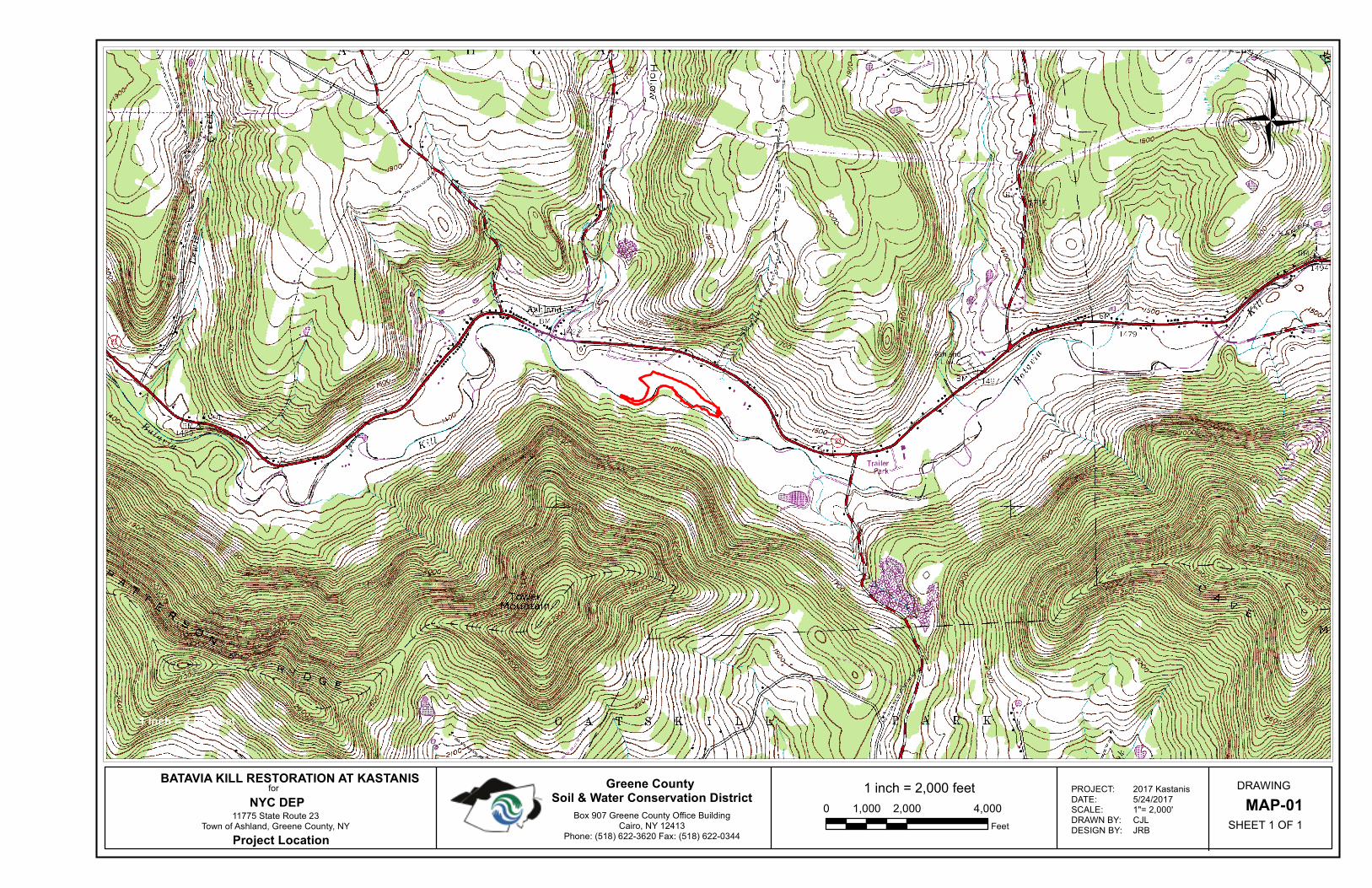
1 inch = 2,000 feet
0 2,000 4,0001,000
Feet
DRAWING
MAP-01
SHEET 1 OF 1Box 907 Greene County Office Building
Cairo, NY 12413Phone: (518) 622-3620 Fax: (518) 622-0344
Greene County Soil & Water Conservation District
BATAVIA KILL RESTORATION AT KASTANISfor
NYC DEP11775 State Route 23
Town of Ashland, Greene County, NY
Project Location
1 inch = 2,000 feet
PROJECT:DATE:SCALE:DRAWN BY:DESIGN BY:
2017 Kastanis5/24/20171"= 2,000'CJLJRB
Ü

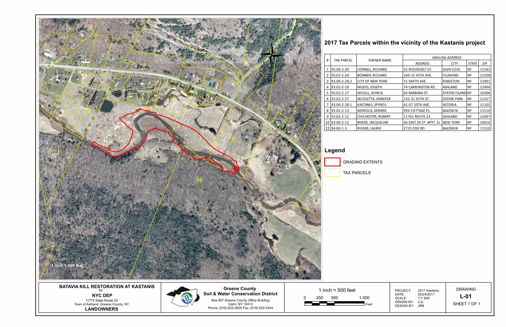
1 inch = 500 feet
0 500 1,000250
Feet
DRAWING
L-01
SHEET 1 OF 1
«1
«4
«3
«6«5
«2
«8
«7 «9
«10
«11
Box 907 Greene County Office BuildingCairo, NY 12413
Phone: (518) 622-3620 Fax: (518) 622-0344
Greene County Soil & Water Conservation District
BATAVIA KILL RESTORATION AT KASTANISfor
NYC DEP11775 State Route 23
Town of Ashland, Greene County, NY
LANDOWNERS
1 inch = 500 feet
Legend
GRADING EXTENTS
TAX PARCELS
PROJECT:DATE:SCALE:DRAWN BY:DESIGN BY:
2017 Kastanis05/24/20171"= 500'CJLJRB
2017 Tax Parcels within the vicinity of the Kastanis project
Ü ADDRESS CITY STATE ZIP
1 93.00-2-29 CORNELL, RICHARD 22 ROOSEVELT ST. GLEN COVE NY 11542
2 93.02-2-24 BONNEN, RICHARD 160-15 45TH AVE. FLUSHING NY 11358
3 93.00-2-28.2 CITY OF NEW YORK 71 SMITH AVE. KINGSTON NY 12401
4 93.02-2-19 MUZIO, JOSEPH 74 CARRINGTON RD. ASHLAND NY 12496
5 93.02-2-17 MCGILL, JOHN B. 64 BARBARA ST. STATEN ISLAND NY 10306
6 93.02-2-37 NICOLETTA, JENNIFER 135-31 95TH ST. OZONE PARK NY 11417
7 93.00-2-28.1 KASTANIS, SPYROS 41-07 20TH AVE. ASTORIA NY 11105
8 93.02-2-13 MERESCA, GERARD 994 COTTAGE PL. BALDWIN NY 11510
9 93.02-2-12 CHICHESTER, ROBERT 11761 ROUTE 23 ASHLAND NY 12407
10 93.00-2-15 MAIER, JACQUELINE 36 EAST 36 ST. APYT. 5J NEW YORK NY 10016
11 94.00-1-3 RIEGER, LAURIE 2725 FOX RD. BALDWIN NY 11510
MAILING ADDRESS# TAX PARCEL OWNER NAME

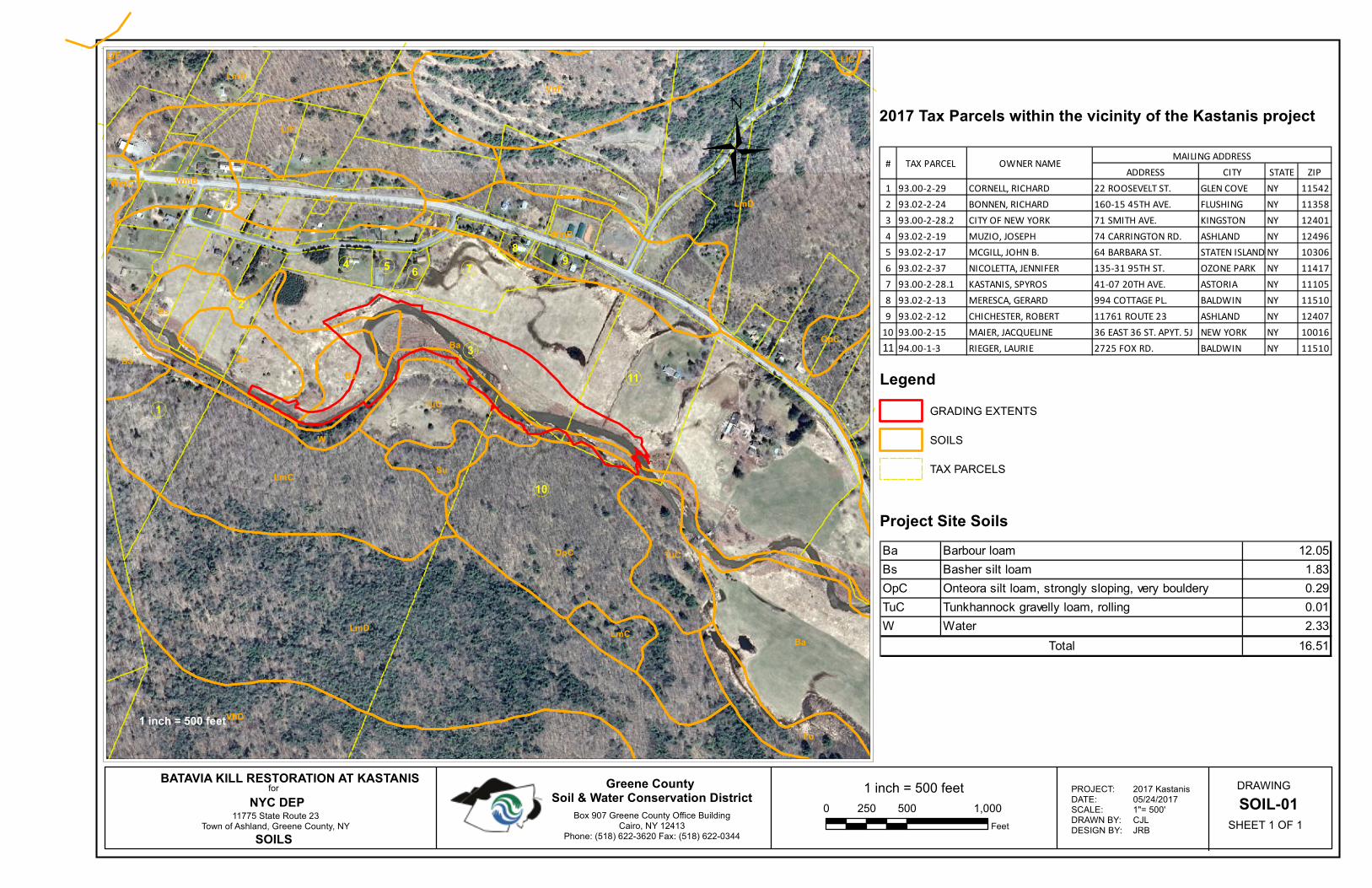
1 inch = 500 feet
0 500 1,000250
Feet
DRAWING
SOIL-01
SHEET 1 OF 1
«1
«4
«3
«6«5
«2
«8
«7 «9
«10
«11
Ba
LmD
LmD
VhD
Ba
LfF
LmC
OpC
W
VhF
Bs
WmB
LmD
LlC
Ba
Fu
TuC
TuC
Ba
Su
Ba
WmB
LmC
OpC
WmC
LlCLfF
Box 907 Greene County Office BuildingCairo, NY 12413
Phone: (518) 622-3620 Fax: (518) 622-0344
Greene County Soil & Water Conservation District
BATAVIA KILL RESTORATION AT KASTANISfor
NYC DEP11775 State Route 23
Town of Ashland, Greene County, NY
SOILS
1 inch = 500 feet
Legend
GRADING EXTENTS
SOILS
TAX PARCELS
PROJECT:DATE:SCALE:DRAWN BY:DESIGN BY:
2017 Kastanis05/24/20171"= 500'CJLJRB
2017 Tax Parcels within the vicinity of the Kastanis project
Ü ADDRESS CITY STATE ZIP
1 93.00-2-29 CORNELL, RICHARD 22 ROOSEVELT ST. GLEN COVE NY 11542
2 93.02-2-24 BONNEN, RICHARD 160-15 45TH AVE. FLUSHING NY 11358
3 93.00-2-28.2 CITY OF NEW YORK 71 SMITH AVE. KINGSTON NY 12401
4 93.02-2-19 MUZIO, JOSEPH 74 CARRINGTON RD. ASHLAND NY 12496
5 93.02-2-17 MCGILL, JOHN B. 64 BARBARA ST. STATEN ISLAND NY 10306
6 93.02-2-37 NICOLETTA, JENNIFER 135-31 95TH ST. OZONE PARK NY 11417
7 93.00-2-28.1 KASTANIS, SPYROS 41-07 20TH AVE. ASTORIA NY 11105
8 93.02-2-13 MERESCA, GERARD 994 COTTAGE PL. BALDWIN NY 11510
9 93.02-2-12 CHICHESTER, ROBERT 11761 ROUTE 23 ASHLAND NY 12407
10 93.00-2-15 MAIER, JACQUELINE 36 EAST 36 ST. APYT. 5J NEW YORK NY 10016
11 94.00-1-3 RIEGER, LAURIE 2725 FOX RD. BALDWIN NY 11510
MAILING ADDRESS# TAX PARCEL OWNER NAME
Project Site Soils
Ba Barbour loam 12.05
Bs Basher silt loam 1.83
OpC Onteora silt loam, strongly sloping, very bouldery 0.29
TuC Tunkhannock gravelly loam, rolling 0.01
W Water 2.33
16.51Total

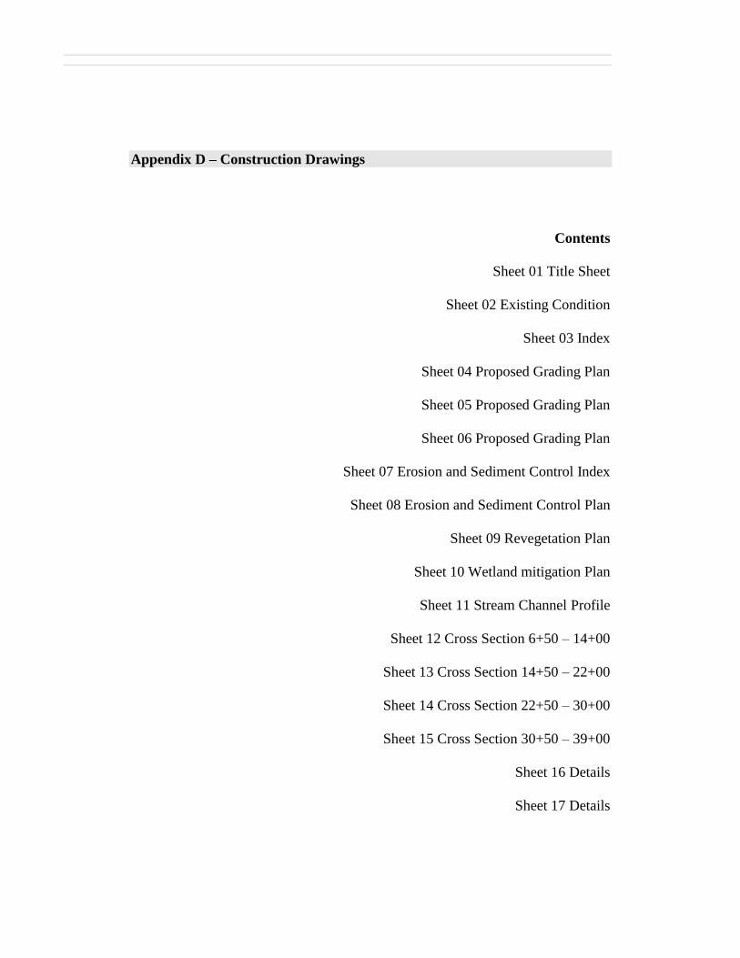
Appendix D – Construction Drawings
Contents
Sheet 01 Title Sheet
Sheet 02 Existing Condition
Sheet 03 Index
Sheet 04 Proposed Grading Plan
Sheet 05 Proposed Grading Plan
Sheet 06 Proposed Grading Plan
Sheet 07 Erosion and Sediment Control Index
Sheet 08 Erosion and Sediment Control Plan
Sheet 09 Revegetation Plan
Sheet 10 Wetland mitigation Plan
Sheet 11 Stream Channel Profile
Sheet 12 Cross Section 6+50 – 14+00
Sheet 13 Cross Section 14+50 – 22+00
Sheet 14 Cross Section 22+50 – 30+00
Sheet 15 Cross Section 30+50 – 39+00
Sheet 16 Details
Sheet 17 Details


![NYCDEP BWT JOC-TOC Coordination [Autosaved]](https://img.pdfslide.us/doc/110x75/589d22731a28abeb478b4df1/nycdep-bwt-joc-toc-coordination-autosaved.jpg)