Embed Size (px)
Citation preview
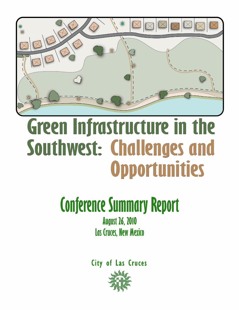
Conference Summary Report August 26, 2010
Las Cruces, New Mexico
City of Las Cruces
Green Infrastructure in the Southwest: Challenges & Opportunities
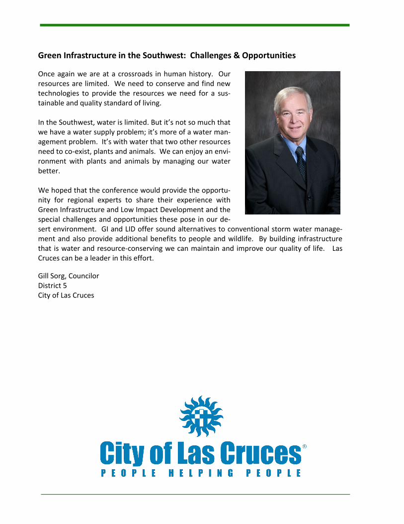
Once again we are at a crossroads in human history. Our resources are limited. We need to conserve and find new technologies to provide the resources we need for a sus-tainable and quality standard of living. In the Southwest, water is limited. But it’s not so much that we have a water supply problem; it’s more of a water man-agement problem. It’s with water that two other resources need to co-exist, plants and animals. We can enjoy an envi-ronment with plants and animals by managing our water better. We hoped that the conference would provide the opportu-nity for regional experts to share their experience with Green Infrastructure and Low Impact Development and the special challenges and opportunities these pose in our de-sert environment. GI and LID offer sound alternatives to conventional storm water manage-ment and also provide additional benefits to people and wildlife. By building infrastructure that is water and resource-conserving we can maintain and improve our quality of life. Las Cruces can be a leader in this effort.
Gill Sorg, Councilor District 5 City of Las Cruces
Table of Contents Executive Summary 4
Joint Introductory Session 5 Overview of Green Infrastructure Legislation in the US Senate
6 EPA’s Green Infrastructure Initiative and Stormwater Rulemaking
Session 1A
Planning for, Designing, and Constructing Sustainable Transportation Infrastructure 8
Green Streets and Building Community Capacity 10 Session 1B
Trees are the Green in Green Infrastructure 12
Xeriscaping in Chihuahua, Mexico 14 Session 1C
Drainage Design: The Quantity/Quality Relationship 16
Construction Products and Techniques for Low Impact Development 18 Session 2A
Facilitating Affordable Green Infrastructure Retrofits: Developing Design Standards for Tucson, AZ 20 Session 2B
Integrated Community Planning: Finding Ways to Do More with Less 22 Session 2C
Ecological Restoration of the Rio Grande 24
Low Impact Development Measures for Protection of Groundwater 26 Key Note
Low Impact Development and Green Infrastructure Pathways to Success 28 Session 3A
Retrofitting Existing Development with Green Infrastructure 31 Session 3B
GI and LID in Semi-Arid Environments: The Albuquerque Experience 34
Stormwater as Part of an Integrated Site Solution: A Case Study of the Hahn Arroyo, Albuquerque, NM 36 Session 3C
GI-GIS: Talking Data and GIS Analysis for Green Infrastructure (GI) Planning 38 Session 4A
Panel Discussion: GI/LID and Local Governments 40 Session 4B
Skyscapes 44
Green Roofs for Healthy Cities 46 Session 4C
Stormwater Harvesting: Converting Nuisance Runoff into a Beneficial Resource While Saving Money 48
A Word from the Organizing Committee 50
Conference Sponsors 51
Executive Summary In April 2010, the City of Las Cruces formed a green infrastructure working group to address a focus area of the Picturing El Paseo Project. Their goal was to raise awareness about the application of green infrastructure principles to infrastructure and development projects. The GI working group was influenced by several City of Las Cruces staff members who attended the Albuquerque Arid GI/LID Workshop. They saw the benefits of hosting a similar event in Las Cruces. The GI working group became the GI Conference Organizing Committee. Their efforts resulted in Green Infrastructure in the Southwest: Challenges & Opportunities on August 26, 2010. The GI conference was held at the Ramada Palms Conference Center in Las Cruces, New Mexico. It was attended by ap-proximately 200 people, including engineers, developers, community activists, scientists, and many others with an interest in a sustainable future for the region. Planning, development and design staff attended from the City of Las Cruces, Doña Ana County, New Mexico State University, El Paso Water Utilities, the City of El Paso, and the University of Texas at El Paso. Tom Schuster, Sustainability Officer for the City of Las Cruces, opened the conference by welcoming the participants. Dara Parker, Field Representative of Senator Jeff Bingaman, made a statement on behalf of the Senator. She stressed the impor-tance of GI to the future of New Mexico and affirmed Senator Bingaman’s support for the region’s sustainability efforts. The opening session speaker was Suzanna Perea, Green Infrastructure Coordinator for EPA Region 6. Suzanna helped plan the conference and provided EPA funding in support of the conference. She set the foundation for the day’s technical ses-sions by discussing the effects of storm water on water quality and EPA’s storm water regulatory program. She explained the role EPA hopes GI will play in improving water quality and the steps EPA is taking to revise the storm water permitting program. The conference offered three parallel technical sessions through the day. A total of 24 presenters covered a wide range of topics related to GI/LID. The sessions included formal presentations and interactive exercises. Exhibits were available for participants who wanted more details on a GI method or construction materials. The networking and sharing of ideas throughout the day was the most valuable part of the conference for many participants. The conference luncheon started with Representative Harry Teague of the NM 2nd Congressional District giving a few re-marks in support of the conference’s goals. The luncheon keynote speaker was Neil Weinstein, Executive Director and one of the founders of the non-profit Low Impact Development Center. He provided a national perspective on GI and lessons learned from implementation of GI in other communities. It was an opportunity for the participants to see the ways GI functions in a community and to learn about resources available for implementing GI. After the conference, the GI working group met again to discuss ways to build upon the positive results of the conference. This GI Conference Summary Report is one of those ways. The report contains summaries of the conference’s presenta-tions and the questions and discussion that accompanied the presentations. It also contains the complete presentations in electronic format. The GI working group hopes the report will be a resource and a tool for furthering the implementation of GI in the region. The City of Las Cruces has started reviewing its ordinances, standards, and criteria to identify changes needed to encourage sustainable development using GI and LID methods. Feedback from conference participants indicates that developing de-sign, operation, and maintenance criteria specific to the arid Southwest may be the foremost need. Future efforts of the GI working group will be in this direction. For more information on the Sustainability Program, please visit www.las-cruces.org and click on Environment and Sustainability Program.
Page 4 GREEN INFRASTRUCTURE CONFERENCE SUMMARY REPORT
Overview of Green Infrastructure Legislation in the US Senate
Xochitl Torres, Field Representative for NM Senator Tom Udall
Biographical Information
Tom Udall became New Mexico's 17th United States
Senator on January 6, 2009, after two decades of public
service as U.S. Representative and New Mexico's State
Attorney General. In the Senate, Tom serves on four
committees, including the Committee on Commerce,
Science and Transportation, the Committee on
Environment and Public Works (EPW), the Committee on
Indian Affairs, and the Committee on Rules and
Administration. As a member of the Environment and
Public Works Committee, Tom introduced several pieces
of legislation, including the Green Infrastructure for Clean
Water Act, which he plans to reintroduce this session. By
promoting greener design of stormwater infrastructure,
we can create jobs, save on construction costs, and help
recharge our aquifers, all while reducing pollution and
flooding of our scenic rivers.
Prior to joining the Senate, Tom represented the 3rd
Congressional District of New Mexico for more than a
decade in the U.S. House of Representatives. During that
time, Tom wrote and passed legislation to establish a
national renewable electricity standard, which would spur
the creation of good jobs and reinvigorate our economy.
Tom began his career in public service in 1990, when New
Mexicans chose him as their Attorney General. He made
fighting DWI and domestic violence a priority and working
with the Legislature, enacted tougher laws against
offenders. Additionally, Tom made ethics a trademark
issue, increasing transparency in government and
prosecuting corrupt politicians, even members of his own
party.
Tom is married to Jill Cooper and they have one grown
daughter. In Tom's spare time he enjoys tennis, fly-fishing,
mountain climbing, and staying involved in his community.
This presentation is available for download by clicking
here.
Presentation Summary and Discussion
Xochitl Torres presented on behalf of Senator Udall.
Traditional stormwater management has resulted in on-
going problems of pollution, flooding, and erosion. At the
same time, we’re wasting a precious resource - water that
can be harvested for use and groundwater recharge. GI is
part of the solution to these problems.
New Mexicans are changing the way we think about
stormwater. The New Mexico State Engineer is
encouraging water harvesting. Santa Fe County mandates
water harvesting, and Bernalillo County offers incentives
for water harvesting.
EPA has a list of GI funding sources at:
http://cfpub.epa.gov/npdes/greeninfrastructure/
fundingopportunities.cfm
Funding is also available through the CARE Grant program,
the CWA Nonpoint Source grants administered by NMED,
and the US Green Building Council’s research program.
Unfortunately, available funding is limited compared to
the problem. Also, most of the GI research is done in
temperate climates, not in the arid southwest.
To address these issues, Senator Udall is working on the
Green Infrastructure for Clean Water Act. It establishes
five regional centers of excellence for GI, one of which
could be in the arid southwest. These centers would
spearhead research and development of GI techniques.
The legislation also establishes a GI program within the
EPA’s Office of Water, which would link research to
potential consumers by educating the public on recent
findings. It further authorizes technical assistance and
project grants for alternative techniques to stormwater
management. The legislation does not alter the Clean
Water Act’s regulatory requirements; rather, it seeks to
expand the options for communities to achieve clean
water standards.
The legislation has been referred to the Environment and
Public Works Committee. Companion legislation was
introduced in the House of Representatives. It is
scheduled for committee mark-up in September. The
legislation could then be included in water/public lands
legislation.
Page 5 GREEN INFRASTRUCTURE CONFERENCE SUMMARY REPORT
EPA’s Green Infrastructure Initiative and
Stormwater Rulemaking
Suzanna M. Perea U.S. Environmental Protection Agency Region 6
Biographical Information
Suzanna Perea earned a BS in Chemistry and an MS in
Environmental Management from Hardin-Simmons
University in Abilene, TX. For the past twelve years,
Suzanna has worked as an environmental scientist in a
variety of Clean Water Act programs at the state and
federal level. Currently, Suzanna coordinates EPA’s Region
6 Green Infrastructure Program efforts in promoting the
benefits of implementing green infrastructure practices to
improve water quality and quantity, and support climate
change mitigation and energy saving efforts.
Abstract
Information in this presentation provides the EPA
background and context for the conference. The
presentation discusses EPA’s green infrastructure program
and objectives, and EPA’s policy efforts in the National
Pollutant Discharge Elimination System (NPDES) program
to facilitate green technologies, through both permitting
and enforcement orders. The intent is to make it easier
for green technologies to be integral parts of Long Term
Control Plans (LTCPs) for combined sewer overflows,
sanitary sewer overflows, and stormwater management
programs.
This presentation is available for download by clicking
here.
Presentation Summary and Discussion
Understanding the stormwater impacts of urban
development, the stormwater regulatory framework and
the municipal stormwater program is essential to
understanding EPA’s future direction for stormwater.
Urban development changes land use. Residential,
industrial and commercial land uses create new pollutant
sources in a watershed. Development construction
increases erosion and contributes sediment as a pollutant
in runoff.
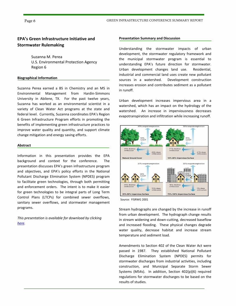
Urban development increases impervious area in a
watershed, which has an impact on the hydrology of the
watershed. An increase in imperviousness decreases
evapotranspiration and infiltration while increasing runoff.
Source: FISRWG 2001
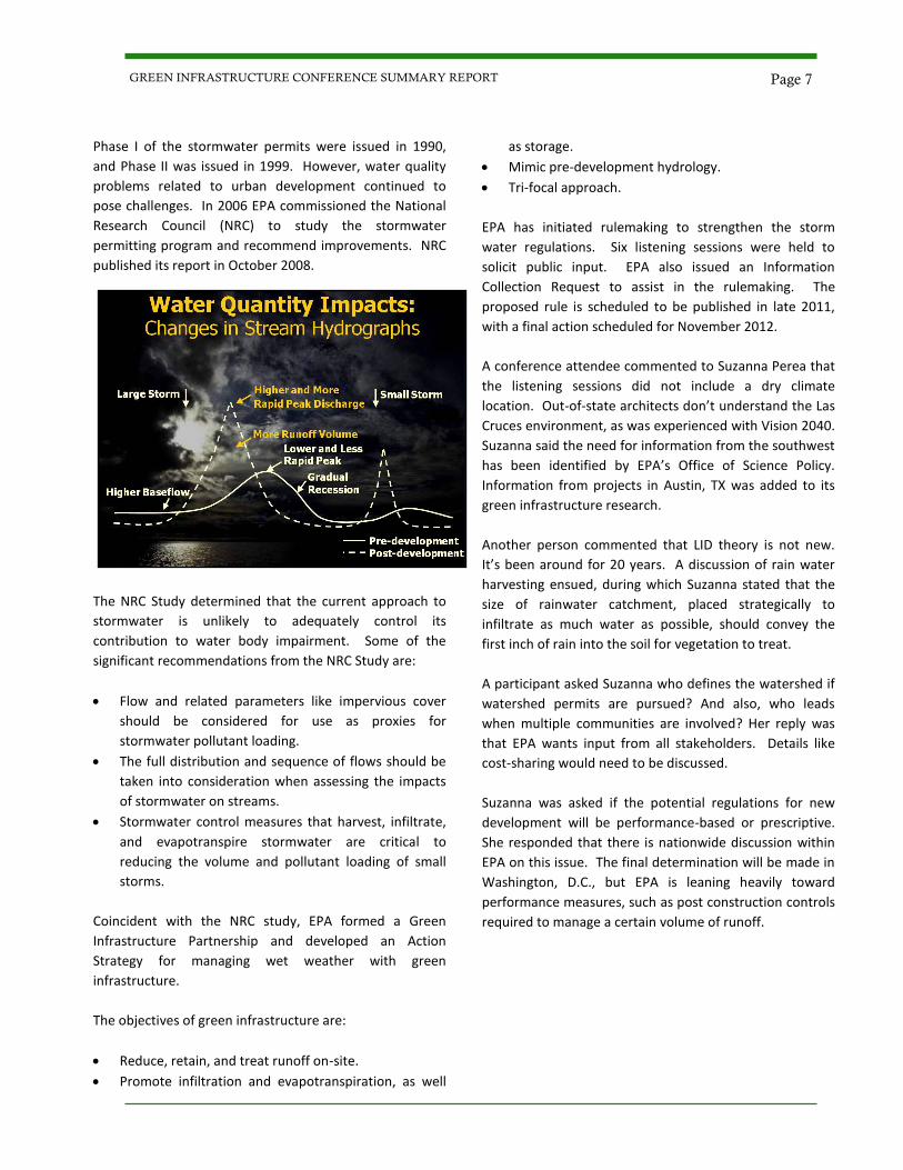
Stream hydrographs are changed by the increase in runoff
from urban development. The hydrograph change results
in stream widening and down-cutting, decreased baseflow
and increased flooding. These physical changes degrade
water quality, decrease habitat and increase stream
temperature and sediment load.
Amendments to Section 402 of the Clean Water Act were
passed in 1987. They established National Pollutant
Discharge Elimination System (NPDES) permits for
stormwater discharges from industrial activities, including
construction, and Municipal Separate Storm Sewer
Systems (MS4s). In addition, Section 402(p)(6) required
regulations for stormwater discharges to be based on the
results of studies.
Page 6 GREEN INFRASTRUCTURE CONFERENCE SUMMARY REPORT
Phase I of the stormwater permits were issued in 1990,
and Phase II was issued in 1999. However, water quality
problems related to urban development continued to
pose challenges. In 2006 EPA commissioned the National
Research Council (NRC) to study the stormwater
permitting program and recommend improvements. NRC
published its report in October 2008.
The NRC Study determined that the current approach to
stormwater is unlikely to adequately control its
contribution to water body impairment. Some of the
significant recommendations from the NRC Study are:
Flow and related parameters like impervious cover
should be considered for use as proxies for
stormwater pollutant loading.
The full distribution and sequence of flows should be
taken into consideration when assessing the impacts
of stormwater on streams.
Stormwater control measures that harvest, infiltrate,
and evapotranspire stormwater are critical to
reducing the volume and pollutant loading of small
storms.
Coincident with the NRC study, EPA formed a Green
Infrastructure Partnership and developed an Action
Strategy for managing wet weather with green
infrastructure.
The objectives of green infrastructure are:
Reduce, retain, and treat runoff on-site.
Promote infiltration and evapotranspiration, as well
as storage.
Mimic pre-development hydrology.
Tri-focal approach.
EPA has initiated rulemaking to strengthen the storm
water regulations. Six listening sessions were held to
solicit public input. EPA also issued an Information
Collection Request to assist in the rulemaking. The
proposed rule is scheduled to be published in late 2011,
with a final action scheduled for November 2012.
A conference attendee commented to Suzanna Perea that
the listening sessions did not include a dry climate
location. Out-of-state architects don’t understand the Las
Cruces environment, as was experienced with Vision 2040.
Suzanna said the need for information from the southwest
has been identified by EPA’s Office of Science Policy.
Information from projects in Austin, TX was added to its
green infrastructure research.
Another person commented that LID theory is not new.
It’s been around for 20 years. A discussion of rain water
harvesting ensued, during which Suzanna stated that the
size of rainwater catchment, placed strategically to
infiltrate as much water as possible, should convey the
first inch of rain into the soil for vegetation to treat.
A participant asked Suzanna who defines the watershed if
watershed permits are pursued? And also, who leads
when multiple communities are involved? Her reply was
that EPA wants input from all stakeholders. Details like
cost-sharing would need to be discussed.
Suzanna was asked if the potential regulations for new
development will be performance-based or prescriptive.
She responded that there is nationwide discussion within
EPA on this issue. The final determination will be made in
Washington, D.C., but EPA is leaning heavily toward
performance measures, such as post construction controls
required to manage a certain volume of runoff.
Page 7 GREEN INFRASTRUCTURE CONFERENCE SUMMARY REPORT
Session 1A
Planning for, Designing, and Constructing
Sustainable Transportation Infrastructure
Dan Andersen
CH2M HILL
Biographical Information
Dan Andersen is a transportation planner with CH2M HILL,
assigned to Nevada, Arizona, and New Mexico, with 25
years of professional experience - 7 years in transportation
planning and 18 years in public relations. He helps clients
and their constituents resolve complex problems and
identify sustainable transportation solutions—solutions
that improve the economic and social quality of human life
while limiting our impacts on the environment to the
carrying capacity of nature. He earned a Bachelor of Arts
in International Relations from Brigham Young University
and a Master of Science in Environmental Management
and Policy from the University of Nevada Las Vegas.
Abstract
This presentation identifies a two-step framework for
developing sustainable transportation solutions and
infrastructure. Step-1 considers a broader range of
solutions to meet mobility needs beyond building or
expanding roads—such as demand management, system
efficiency, and multimodal solutions. When infrastructure
solutions are selected to meet mobility needs, Step-2 is to
develop the projects in more sustainable ways by aligning
to five broad objectives, described in the Greenroads
Sustainability Performance Metric: Reduce Energy
Consumption; Reduce Consumption of Material
Resources; Reduce Impacts to Environmental Resources;
Support Healthy Urban Communities; and Support
Sustainability during Implementation.
This presentation is available for download by clicking
here.
Presentation Summary and Discussion
Sustainable transportation should be cost efficient and
affordable, provide equitable access and mobility choices,
and be compatible with the natural environment.
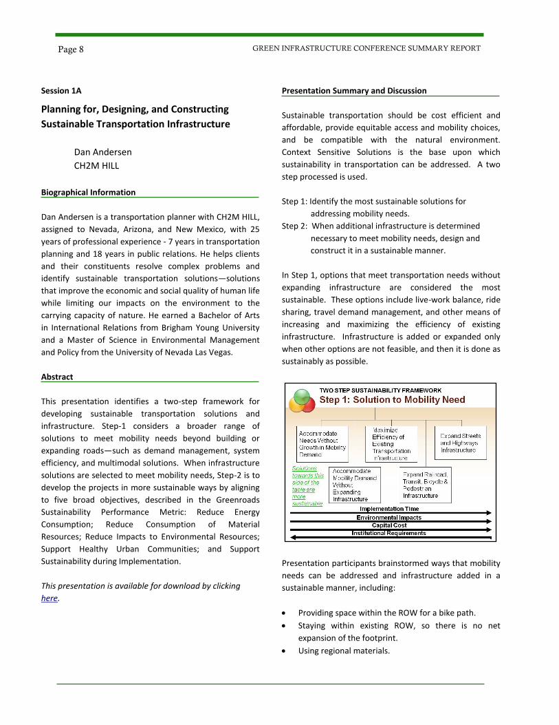
Context Sensitive Solutions is the base upon which
sustainability in transportation can be addressed. A two
step processed is used.
Step 1: Identify the most sustainable solutions for
addressing mobility needs.
Step 2: When additional infrastructure is determined
necessary to meet mobility needs, design and
construct it in a sustainable manner.
In Step 1, options that meet transportation needs without
expanding infrastructure are considered the most
sustainable. These options include live-work balance, ride
sharing, travel demand management, and other means of
increasing and maximizing the efficiency of existing
infrastructure. Infrastructure is added or expanded only
when other options are not feasible, and then it is done as
sustainably as possible.
Presentation participants brainstormed ways that mobility
needs can be addressed and infrastructure added in a
sustainable manner, including:
Providing space within the ROW for a bike path.
Staying within existing ROW, so there is no net
expansion of the footprint.
Using regional materials.
Page 8 GREEN INFRASTRUCTURE CONFERENCE SUMMARY REPORT
Re-using asphalt or using recycled materials.
Using solar lighting.
Participants then discussed sustainable practices for
constructing new roadways:
Designing to maintain natural drainage ways.
Including wildlife corridors.
Incorporating HOV lanes into the highway.
Providing charging stations for electric vehicles.
When additional infrastructure is deemed necessary to
meet mobility needs, Step 2 encourages practices for
designing and constructing it in a sustainable manner. One
challenge is quantifying green elements. The LEED rating
system does include metrics for sustainable transportation
infrastructure. The University of Washington and CH2M
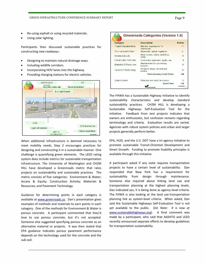
HILL have developed a Greenroads metric that rates
projects on sustainability and sustainable practices. The
metric consists of five categories: Environment & Water;
Access & Equity; Construction Activity; Materials &
Resources; and Pavement Technology.
Guidance for determining points in each category is
available at www.greenroads.us. Dan’s presentation gives
examples of methods and materials to earn points in each
category. One of the methods for Environment & Water is
porous concrete. A participant commented that they’d
love to use porous concrete, but it’s not accepted.
Someone else suggested specifying porous concrete as an
alternative material or projects. It was then stated that
EPA guidance indicates porous pavement performance
depends on the technology used for the concrete and the
sub-soil.
The FHWA has a Sustainable Highway Initiative to identify
sustainability characteristics and develop standard
sustainability practices. CH2M HILL is developing a
Sustainable Highways Self-Evaluation Tool for the
initiative. Feedback from test projects indicates that
owners are enthusiastic, but confusion remains regarding
terminology and criteria. Evaluation results are varied.
Agencies with robust system policies and urban and larger
projects generally perform better.
EPA, HUD, and the U.S. DOT have a tri-agency initiative to
promote sustainable Transit-Oriented Development and
Smart Growth. Funding to promote livability principles is
available through this initiative.
A participant asked if any state requires transportation
projects to have a certain level of sustainability. Dan
responded that New York has a requirement for
sustainability from design through maintenance.
Someone else inquired about linking land use and
transportation planning at the highest planning levels.
Dan indicated yes, it is being done as agency-level criteria.
The FHWA is also looking at the land use-transportation
planning link as system-level criteria. When asked, Dan
said the Sustainable Highways Self-Evaluation Tool is not
yet available to the public. (Ed. Note: It is now at
www.sustainablehighways.org). A final comment was
made by a participant, who said that AASHTO and LEED
recently announced separate efforts to develop guidelines
for transportation sustainability.
Page 9 GREEN INFRASTRUCTURE CONFERENCE SUMMARY REPORT
Session 1A
Green Streets and Building Community Capacity
James MacAdam, LEED-AP Watershed Management Group (WMG) Biographical Information
James MacAdam is the Green Streets – Green Neighbor-
hoods Program Manager at WMG. James works for water-
shed education and community development in south-
western neighborhoods, largely through use of green in-
frastructure strategies. Certified in Permaculture Design,
trained in community activism, and a LEED-Accredited
Professional, James has worked as a botanist, design con-
sultant, and corporate sustainability coordinator. With a
passion for teaching, he has taught ecological and sustain-
ability curriculum in outdoor education, business, commu-
nity, and college settings.
Abstract
Imagine a neighborhood streetscape which invites resi-
dents to enjoy walking, cycling, or socializing along its at-
tractive and shaded streets. Stormwater often perceived
as a flooding and pollutant nuisance irrigates native green-
scapes to provide multiple benefits for people and the
environment. Through Green Streets - Green Neighbor-
hoods, Watershed Management Group (WMG) works with
neighborhoods, homeowner associations, businesses, gov-
ernment, and informal community groups to promote and
install green infrastructure practices to improve commu-
nity livability. The program provides citizens with the skills
and resources to problem-solve and take action on issues
of flooding, stormwater pollution, urban heat island effect,
alternative transportation, and neighborhood beautifica-
tion in their own neighborhoods.
This presentation is available for download by clicking
here.
Presentation Summary and Discussion
Watershed Management Group (WMG) is a Tucson, AZ
non-profit that engages residents in improving their qual-
ity of life and the health of the environment. WMG ac-
complishes this goal through hands-on implementation
projects. These projects cultivate watershed stewardship
and develop local leadership to drive policy changes.
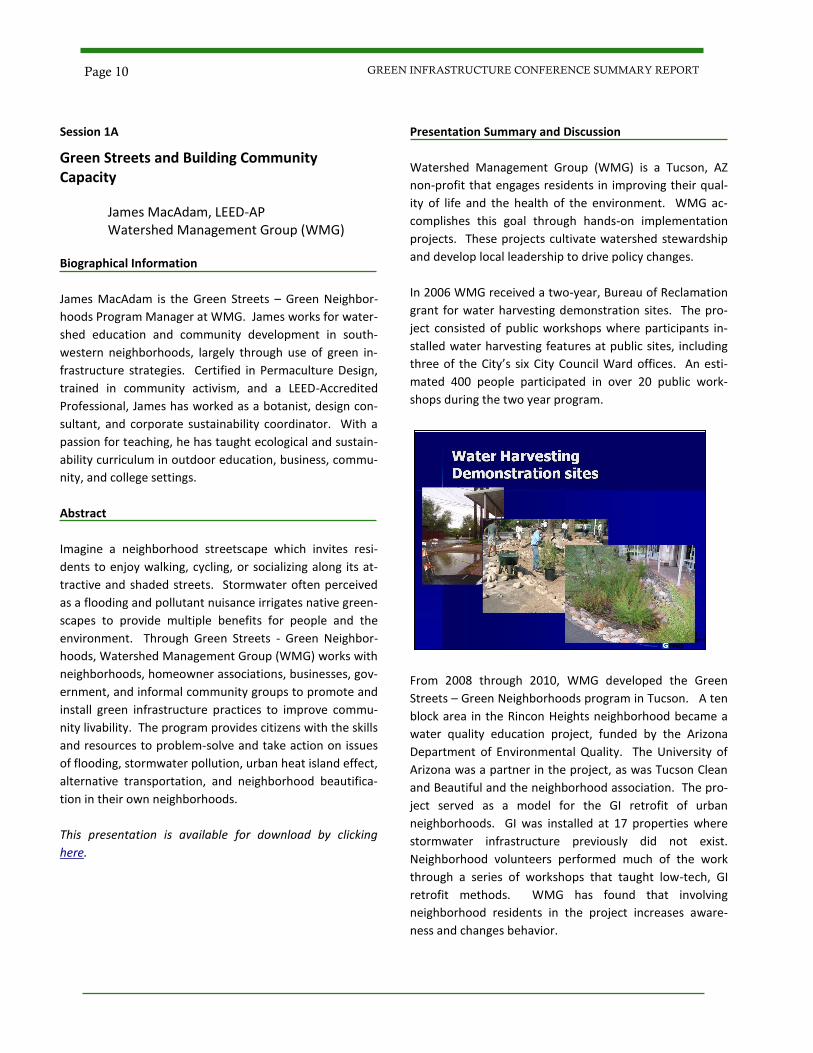
In 2006 WMG received a two-year, Bureau of Reclamation
grant for water harvesting demonstration sites. The pro-
ject consisted of public workshops where participants in-
stalled water harvesting features at public sites, including
three of the City’s six City Council Ward offices. An esti-
mated 400 people participated in over 20 public work-
shops during the two year program.
From 2008 through 2010, WMG developed the Green
Streets – Green Neighborhoods program in Tucson. A ten
block area in the Rincon Heights neighborhood became a
water quality education project, funded by the Arizona
Department of Environmental Quality. The University of
Arizona was a partner in the project, as was Tucson Clean
and Beautiful and the neighborhood association. The pro-
ject served as a model for the GI retrofit of urban
neighborhoods. GI was installed at 17 properties where
stormwater infrastructure previously did not exist.
Neighborhood volunteers performed much of the work
through a series of workshops that taught low-tech, GI
retrofit methods. WMG has found that involving
neighborhood residents in the project increases aware-
ness and changes behavior.
Page 10 GREEN INFRASTRUCTURE CONFERENCE SUMMARY REPORT
At this point, James MacAdam was asked, “Who takes
ownership responsibility when the landscaping gets too
big?” His response was that a Volunteer Association or a
Neighborhood Association takes ownership or responsibil-
ity. When asked if there was any pushback from the
neighborhood, he replied, “No.”
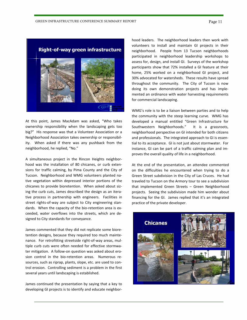
A simultaneous project in the Rincon Heights neighbor-
hood was the installation of 80 chicanes, or curb exten-
sions for traffic calming, by Pima County and the City of
Tucson. Neighborhood and WMG volunteers planted na-
tive vegetation within depressed interior portions of the
chicanes to provide bioretention. When asked about siz-
ing the curb cuts, James described the design as an itera-
tive process in partnership with engineers. Facilities in
street rights-of-way are subject to City engineering stan-
dards. When the capacity of the bio-retention area is ex-
ceeded, water overflows into the streets, which are de-
signed to City standards for conveyance.
James commented that they did not replicate some biore-
tention designs, because they required too much mainte-
nance. For retrofitting streetside right-of-way areas, mul-
tiple curb cuts were often needed for effective stormwa-
ter mitigation. A follow-on question was asked about ero-
sion control in the bio-retention areas. Numerous re-
sources, such as riprap, plants, slope, etc. are used to con-
trol erosion. Controlling sediment is a problem in the first
several years until landscaping is established.
James continued the presentation by saying that a key to
developing GI projects is to identify and educate neighbor-
hood leaders. The neighborhood leaders then work with
volunteers to install and maintain GI projects in their
neighborhood. People from 13 Tucson neighborhoods
participated in neighborhood leadership workshops to
assess for, design, and install GI. Surveys of the workshop
participants show that 72% installed a GI feature at their
home, 25% worked on a neighborhood GI project, and
30% advocated for watersheds. These results have spread
throughout the community. The City of Tucson is now
doing its own demonstration projects and has imple-
mented an ordinance with water harvesting requirements
for commercial landscaping.
WMG’s role is to be a liaison between parties and to help
the community with the steep learning curve. WMG has
developed a manual entitled “Green Infrastructure for
Southwestern Neighborhoods.” It is a grassroots,
neighborhood perspective on GI intended for both citizens
and professionals. The integrated approach to GI is essen-
tial to its acceptance. GI is not just about stormwater. For
instance, GI can be part of a traffic calming plan and im-
proves the overall quality of life in a neighborhood.
At the end of the presentation, an attendee commented
on the difficulties he encountered when trying to do a
Green Street subdivision in the City of Las Cruces. He had
traveled to Tucson on the Armory tour to see a subdivision
that implemented Green Streets – Green Neighborhood
projects. Seeing the subdivision made him wonder about
financing for the GI. James replied that it’s an integrated
practice of the private developer.
Page 11 GREEN INFRASTRUCTURE CONFERENCE SUMMARY REPORT
Session 1B
Trees are the Green in Green Infrastructure
Lance Davisson, ISA Certified Arborist New Mexico State Forestry Nicholas Kuhn, ISA Certified Arborist, Municipal Specialist City of Albuquerque
Biographical Information
Lance Davisson has worked in a variety of natural resource
management positions since 2000 in Washington and New
Mexico. Lance works with NM communities, helping them
maximize the benefits of trees by providing resources,
education, and funding opportunities. As program
manager, Lance is an ISA Certified Arborist and
administers other Forestry Division programs, including:
the NM Forest Re-Leaf Program, the State Big Tree
Program, and the Arbor Day Foundation’s Tree City USA
and Tree Campus USA programs.
Nicholas “Nick” Kuhn is the City Forester for Albuquerque,
and has worked in Forestry since 1991 and Municipal
Forestry since 2000. He has been an ISA Certified Arborist
with Municipal Specialty since 1998. Other activities
include being a Technical Advisor to the Sustainable Sites
Initiative, which is now in pilot phase to update the LEED
rating system with more credit for natural systems. Nick
works extensively with local, state and national groups to
advocate for trees in all municipal programs.
Abstract
How we plan and choose the best available tools,
combining technology and natural resources, has the
greatest impact on our municipal environmental systems.
Trees should be the primary tool providing the greatest
overall benefit for public use and municipal needs.
Strategic planning using a green infrastructure approach
identifies the best lands to conserve and the best lands to
accommodate development, in order to help communities
balance environmental and economic goals through
strategies that lead to smarter, sustainable land uses.
This presentation is not available online. For more
information, contact the City of Las Cruces Sustainability
Program at 575-528-3069.
Presentation Summary and Discussion
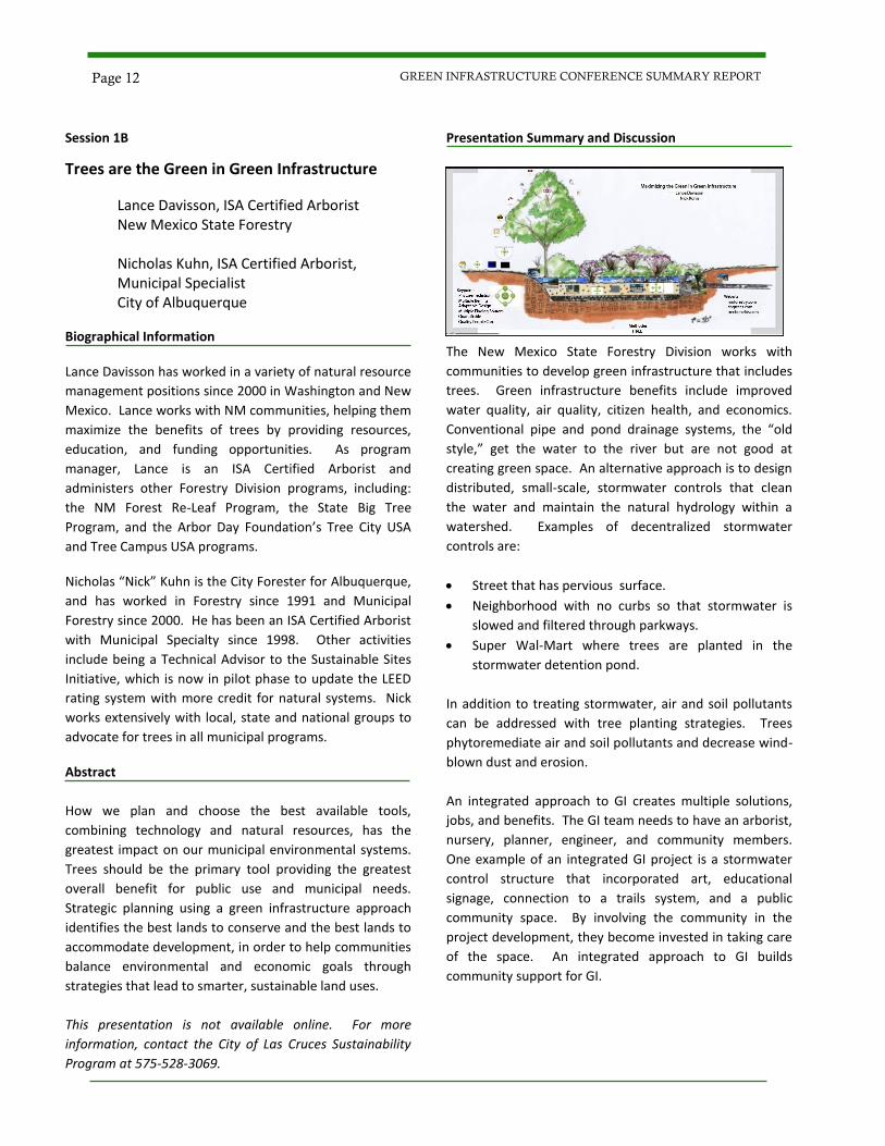
The New Mexico State Forestry Division works with
communities to develop green infrastructure that includes
trees. Green infrastructure benefits include improved
water quality, air quality, citizen health, and economics.
Conventional pipe and pond drainage systems, the “old
style,” get the water to the river but are not good at
creating green space. An alternative approach is to design
distributed, small-scale, stormwater controls that clean
the water and maintain the natural hydrology within a
watershed. Examples of decentralized stormwater
controls are:
Street that has pervious surface.
Neighborhood with no curbs so that stormwater is
slowed and filtered through parkways.
Super Wal-Mart where trees are planted in the
stormwater detention pond.
In addition to treating stormwater, air and soil pollutants
can be addressed with tree planting strategies. Trees
phytoremediate air and soil pollutants and decrease wind-
blown dust and erosion.
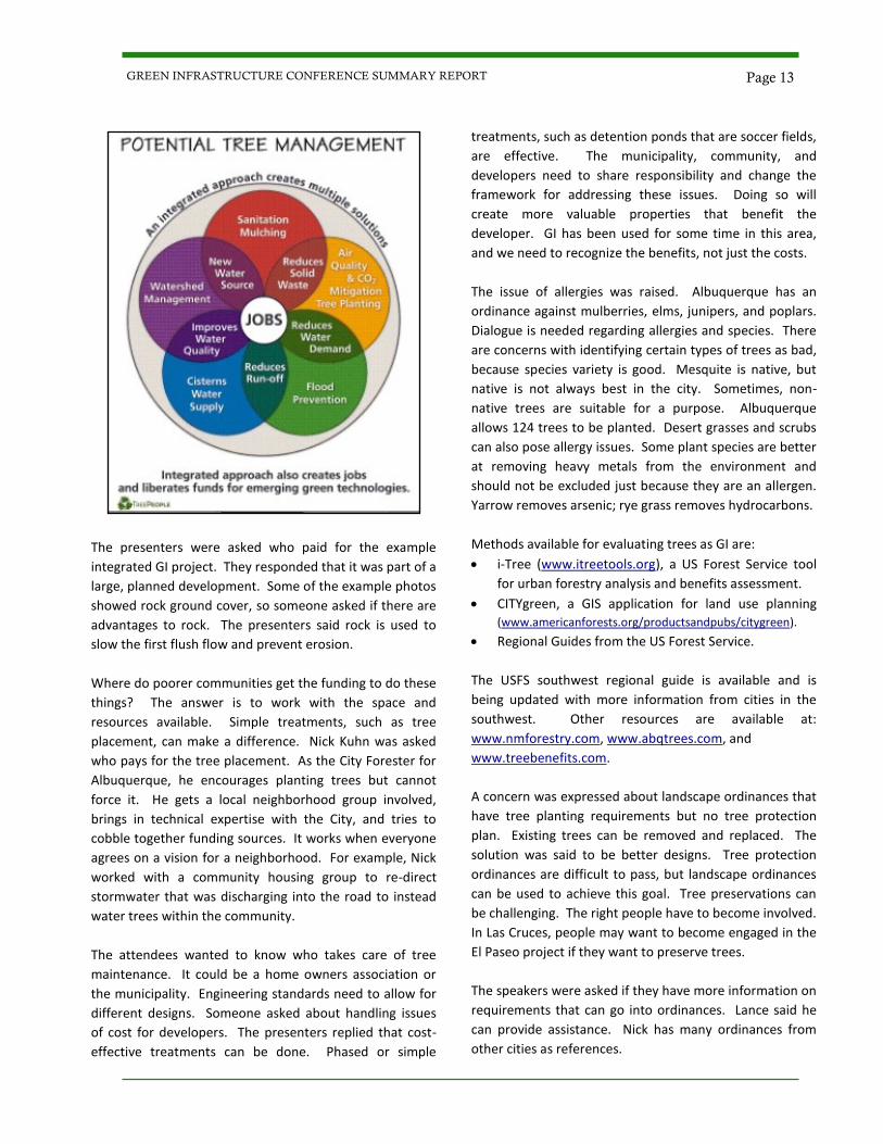
An integrated approach to GI creates multiple solutions,
jobs, and benefits. The GI team needs to have an arborist,
nursery, planner, engineer, and community members.
One example of an integrated GI project is a stormwater
control structure that incorporated art, educational
signage, connection to a trails system, and a public
community space. By involving the community in the
project development, they become invested in taking care
of the space. An integrated approach to GI builds
community support for GI.
Page 12 GREEN INFRASTRUCTURE CONFERENCE SUMMARY REPORT
The presenters were asked who paid for the example
integrated GI project. They responded that it was part of a
large, planned development. Some of the example photos
showed rock ground cover, so someone asked if there are
advantages to rock. The presenters said rock is used to
slow the first flush flow and prevent erosion.
Where do poorer communities get the funding to do these
things? The answer is to work with the space and
resources available. Simple treatments, such as tree
placement, can make a difference. Nick Kuhn was asked
who pays for the tree placement. As the City Forester for
Albuquerque, he encourages planting trees but cannot
force it. He gets a local neighborhood group involved,
brings in technical expertise with the City, and tries to
cobble together funding sources. It works when everyone
agrees on a vision for a neighborhood. For example, Nick
worked with a community housing group to re-direct
stormwater that was discharging into the road to instead
water trees within the community.
The attendees wanted to know who takes care of tree
maintenance. It could be a home owners association or
the municipality. Engineering standards need to allow for
different designs. Someone asked about handling issues
of cost for developers. The presenters replied that cost-
effective treatments can be done. Phased or simple
treatments, such as detention ponds that are soccer fields,
are effective. The municipality, community, and
developers need to share responsibility and change the
framework for addressing these issues. Doing so will
create more valuable properties that benefit the
developer. GI has been used for some time in this area,
and we need to recognize the benefits, not just the costs.
The issue of allergies was raised. Albuquerque has an
ordinance against mulberries, elms, junipers, and poplars.
Dialogue is needed regarding allergies and species. There
are concerns with identifying certain types of trees as bad,
because species variety is good. Mesquite is native, but
native is not always best in the city. Sometimes, non-
native trees are suitable for a purpose. Albuquerque
allows 124 trees to be planted. Desert grasses and scrubs
can also pose allergy issues. Some plant species are better
at removing heavy metals from the environment and
should not be excluded just because they are an allergen.
Yarrow removes arsenic; rye grass removes hydrocarbons.
Methods available for evaluating trees as GI are:
i-Tree (www.itreetools.org), a US Forest Service tool
for urban forestry analysis and benefits assessment.
CITYgreen, a GIS application for land use planning
(www.americanforests.org/productsandpubs/citygreen).
Regional Guides from the US Forest Service.
The USFS southwest regional guide is available and is
being updated with more information from cities in the
southwest. Other resources are available at:
www.nmforestry.com, www.abqtrees.com, and
www.treebenefits.com.
A concern was expressed about landscape ordinances that
have tree planting requirements but no tree protection
plan. Existing trees can be removed and replaced. The
solution was said to be better designs. Tree protection
ordinances are difficult to pass, but landscape ordinances
can be used to achieve this goal. Tree preservations can
be challenging. The right people have to become involved.
In Las Cruces, people may want to become engaged in the
El Paseo project if they want to preserve trees.
The speakers were asked if they have more information on
requirements that can go into ordinances. Lance said he
can provide assistance. Nick has many ordinances from
other cities as references.
Page 13 GREEN INFRASTRUCTURE CONFERENCE SUMMARY REPORT
Session 1B
Xeriscaping in Chihuahua, Mexico
Toutcha Lebgue Keleng, PhD
University of Chihuahua, Mexico
Biographical Information
Toutcha Lebgue Keleng is a full time professor with a PhD
in Natural Resources at the University of Chihuahua,
Mexico. He is an Aggie from New Mexico State University
with BS in Range Management and MS in Plant Biology.
Dr. Lebgue has published more than 20 scientific articles
and books, including, Flora of the Fort Stanton
Experimental Ranch, Lincoln County, NM, Grasses of
Chihuahua in 3 editions, Manual of Forage Plants, Manual
for the Identification of Range Plants, Manual of the
Xeriscape Plants, Searching for Nelson: A wildflower Guide
for the Copper Canyon Region, and most recently, Cacti of
Chihuahua: State Treasure at Risk of Extinction in 2010.
Abstract
Xeriscaping is a concept of creating beautiful gardens and
yet conserving huge quantities of water as compared to
the traditional landscaping systems. Born in Denver, CO in
1981, the concept was soon embraced by many agencies
especially those dealing with water, land use, sustainable
construction, and environmental conservation, just to
name a few. It is a way of doing gardening by using native
plant species that can provide beauty to the eyes but at
the same time survive on a minimum amount of water.
The southwestern United States and the northern states
of Mexico are entities that survive with very limited
natural water supply. Chihuahua is one such state and its
government, being aware of the problem, has adopted the
xeriscape technique and has developed educational
programs to teach and urge the Chihuahuan communities
to minimize the use of water by creating their own
xerigardens in the front or the backyards of their homes as
well as in the public places in the cities.
This presentation is available for download by clicking
here.
Presentation Summary and Discussion
The City of Chihuahua, Mexico, is in the State of
Chihuahua, which has 70% of its area in the dry climate
zone. The National Water Commission of Mexico
(CONAGUA) has calculated that the cubic meters of
natural water available per person per year has dropped
dramatically from 1950 to 2005 and is projected to drop
further by 2030.
Water availability is probably not the main problem for
the City of Chihuahua at this time, but it is a future
problem critical to the survival of the City. Due to limited
availability, the City has regulated water distribution since
the 1980’s. Water is available to different parts of the City
at different times. For instance, Toutcha says he receives
water twice a day on the regulated system. The
government is building water treatment plants to address
the water availability issues. Currently, there are two
water treatment plants. Water is not used for drinking
unless it is filtered (usually).
The government has implemented steps to address water
availability. A water storage tank (cistern) is mandatory
for all houses. Houses are limited to two cisterns a day,
which allows for all people to get water. The size of tank is
according to how much money the owner has; the more
water used, the more the owner has to pay.
The Xeriscape concept was developed in the City of
Denver, CO in 1981 and has been adapted for use by the
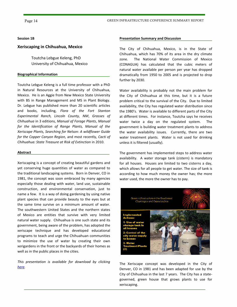
City of Chihuahua in the last 7 years. The City has a state-
governed, green house that grows plants to use for
xeriscaping.
Page 14 GREEN INFRASTRUCTURE CONFERENCE SUMMARY REPORT
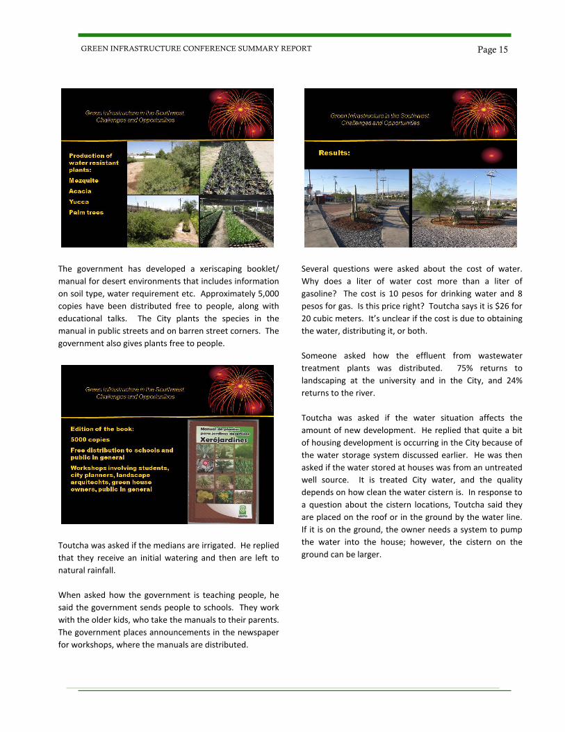
The government has developed a xeriscaping booklet/
manual for desert environments that includes information
on soil type, water requirement etc. Approximately 5,000
copies have been distributed free to people, along with
educational talks. The City plants the species in the
manual in public streets and on barren street corners. The
government also gives plants free to people.
Toutcha was asked if the medians are irrigated. He replied
that they receive an initial watering and then are left to
natural rainfall.
When asked how the government is teaching people, he
said the government sends people to schools. They work
with the older kids, who take the manuals to their parents.
The government places announcements in the newspaper
for workshops, where the manuals are distributed.
Several questions were asked about the cost of water.
Why does a liter of water cost more than a liter of
gasoline? The cost is 10 pesos for drinking water and 8
pesos for gas. Is this price right? Toutcha says it is $26 for
20 cubic meters. It’s unclear if the cost is due to obtaining
the water, distributing it, or both.
Someone asked how the effluent from wastewater
treatment plants was distributed. 75% returns to
landscaping at the university and in the City, and 24%
returns to the river.
Toutcha was asked if the water situation affects the
amount of new development. He replied that quite a bit
of housing development is occurring in the City because of
the water storage system discussed earlier. He was then
asked if the water stored at houses was from an untreated
well source. It is treated City water, and the quality
depends on how clean the water cistern is. In response to
a question about the cistern locations, Toutcha said they
are placed on the roof or in the ground by the water line.
If it is on the ground, the owner needs a system to pump
the water into the house; however, the cistern on the
ground can be larger.
Page 15 GREEN INFRASTRUCTURE CONFERENCE SUMMARY REPORT
Session 1C
Drainage Design: The Quantity/Quality
Relationship
Katrina M. Martich, PE, CPESC
Martich Professional Services, PLLC
Biographical Information
Katrina Martich is the Owner and President of Martich
Professional Services (MPS) in El Paso, Texas. The
company specializes in the protection of soil and water
resources through wind and water erosion control,
stormwater management, pollution prevention planning,
and low impact development. Before starting MPS,
Katrina was an Environmental Manager for the City of
Arlington, TX, where she led a staff that implemented the
City’s Phase I MS4 Stormwater Management Program.
Katrina started her career doing hydraulic analyses for
watershed studies with the U.S. Army Corps of Engineers,
Fort Worth District. After receiving her master’s degree,
she moved into environmental positions with the District,
where her experience included multi-media compliance
audits, environmental investigations, remediation design,
NEPA compliance, and environmental permitting.
Abstract
The National Research Council’s 2008 report on urban
stormwater management documented that designing
drainage infrastructure for flood control and adding “end-
of-pipe” treatment for the first flush of pollutants wasn’t
solving the stormwater pollution problem in urban areas.
This presentation looks at the relationship between the
quantity and quality of runoff. By addressing runoff
quantity through Low Impact Development design
methods, it is possible to design drainage infrastructure
that protects the public from the quantity of runoff while
also improving water quality.
This presentation is available for download by clicking
here.
Presentation Summary and Discussion
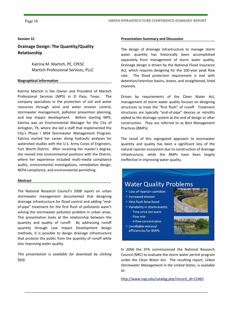
The design of drainage infrastructure to manage storm
water quantity has historically been accomplished
separately from management of storm water quality.
Drainage design is driven by the National Flood Insurance
Act, which requires designing for the 100-year peak flow
rate. The flood protection requirement is met with
detention/retention basins, levees, and straightened, lined
channels.
Driven by requirements of the Clean Water Act,
management of storm water quality focuses on designing
structures to treat the “first flush” of runoff. Treatment
structures are typically “end-of-pipe” devices or retrofits
added to the drainage system at the end of design or after
construction. They are referred to as Best Management
Practices (BMPs).
The result of this segregated approach to stormwater
quantity and quality has been a significant loss of the
natural riparian ecosystem due to construction of drainage
infrastructure, while the BMPs have been largely
ineffective in improving water quality.
In 2006 the EPA commissioned the National Research
Council (NRC) to evaluate the storm water permit program
under the Clean Water Act. The resulting report, Urban
Stormwater Management in the United States, is available
at:
http://www.nap.edu/catalog.php?record_id=12465
Page 16 GREEN INFRASTRUCTURE CONFERENCE SUMMARY REPORT
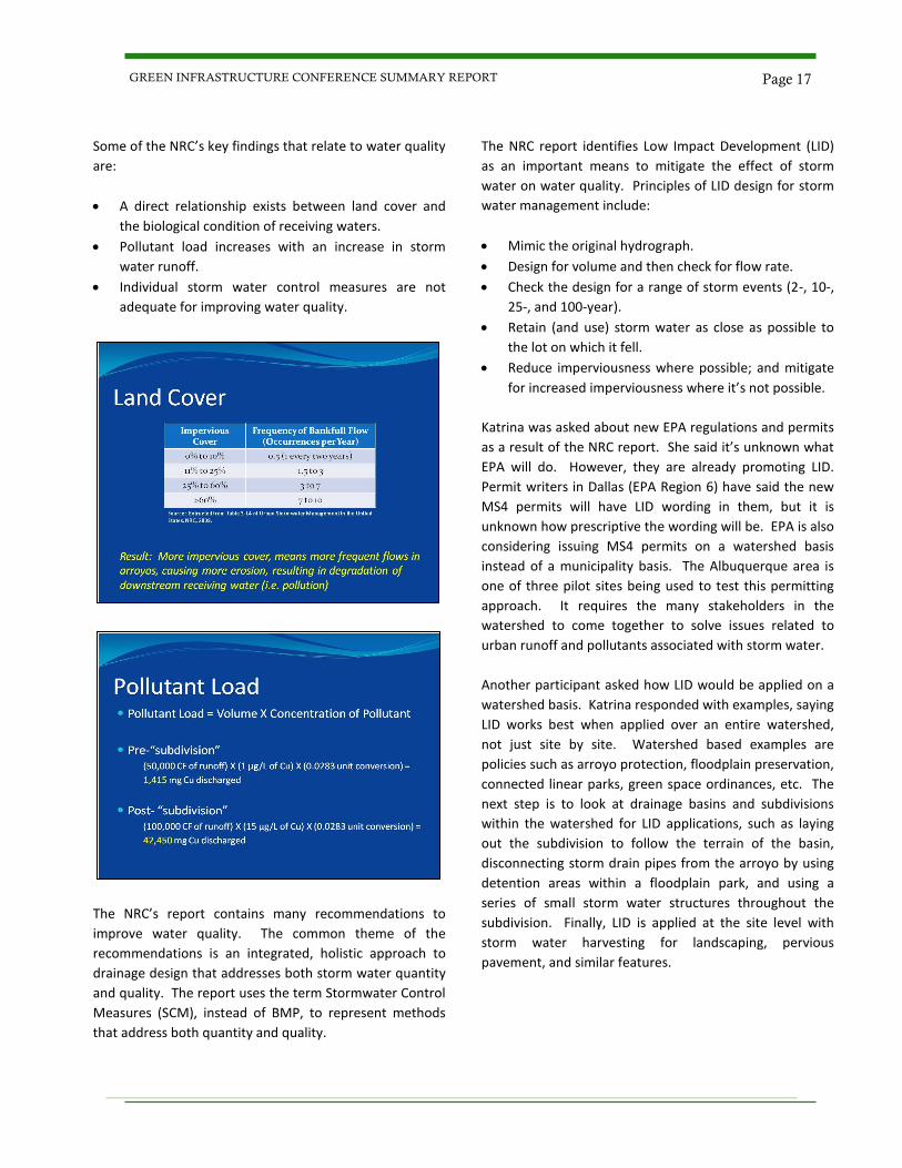
Some of the NRC’s key findings that relate to water quality
are:
A direct relationship exists between land cover and
the biological condition of receiving waters.
Pollutant load increases with an increase in storm
water runoff.
Individual storm water control measures are not
adequate for improving water quality.
The NRC’s report contains many recommendations to
improve water quality. The common theme of the
recommendations is an integrated, holistic approach to
drainage design that addresses both storm water quantity
and quality. The report uses the term Stormwater Control
Measures (SCM), instead of BMP, to represent methods
that address both quantity and quality.
The NRC report identifies Low Impact Development (LID)
as an important means to mitigate the effect of storm
water on water quality. Principles of LID design for storm
water management include:
Mimic the original hydrograph.
Design for volume and then check for flow rate.
Check the design for a range of storm events (2-, 10-,
25-, and 100-year).
Retain (and use) storm water as close as possible to
the lot on which it fell.
Reduce imperviousness where possible; and mitigate
for increased imperviousness where it’s not possible.
Katrina was asked about new EPA regulations and permits
as a result of the NRC report. She said it’s unknown what
EPA will do. However, they are already promoting LID.
Permit writers in Dallas (EPA Region 6) have said the new
MS4 permits will have LID wording in them, but it is
unknown how prescriptive the wording will be. EPA is also
considering issuing MS4 permits on a watershed basis
instead of a municipality basis. The Albuquerque area is
one of three pilot sites being used to test this permitting
approach. It requires the many stakeholders in the
watershed to come together to solve issues related to
urban runoff and pollutants associated with storm water.
Another participant asked how LID would be applied on a
watershed basis. Katrina responded with examples, saying
LID works best when applied over an entire watershed,
not just site by site. Watershed based examples are
policies such as arroyo protection, floodplain preservation,
connected linear parks, green space ordinances, etc. The
next step is to look at drainage basins and subdivisions
within the watershed for LID applications, such as laying
out the subdivision to follow the terrain of the basin,
disconnecting storm drain pipes from the arroyo by using
detention areas within a floodplain park, and using a
series of small storm water structures throughout the
subdivision. Finally, LID is applied at the site level with
storm water harvesting for landscaping, pervious
pavement, and similar features.
Page 17 GREEN INFRASTRUCTURE CONFERENCE SUMMARY REPORT
Session 1C
Construction Products and Techniques for Low Impact Development
Melissa Y. Gorham, EI, LEED-AP, GB-98
Contech Construction Products, Inc. Biographical Information Melissa Gorham has a bachelor’s degree in Civil Engineering, and is a licensed contractor. She has obtained her LEED AP Accreditation and is an active Realtor in Southern New Mexico. Melissa has over 8 years of experience in Project Management and Development. These endeavors include Managing Land Development Projects, Civil Engineering, Construction Management, LEED Implementation, marketing, and Real Estate. Melissa is currently working for Contech Construction Products as a Project Consultant/Sales Engineer. She continues to pursue Green Development as a member of the Boldt Family Trust’s Real Estate and Land Development team. Melissa has a passion for the implementation of green principles, not only in construction, but in everyday life. Abstract There are many methods that can help to lower the
impact of developing sites and create sustainable
developments for the future. This can be accomplished
through the use of a range of BMP options and in
obtaining the knowledge necessary to better understand
and implement LID. We will provide information on
specifying and designing for the use of the most
appropriate products and solutions. On top of this, we will
identify opportunities to obtain valuable LEED credits if
your projects are involved in LEED certification through
appropriate solution selection.
This presentation is available for download by clicking
here.
Presentation Summary and Discussion
Low Impact Development (LID) is an approach to
stormwater management modeled after nature. The basic
principle is to manage rainfall at the source using
uniformly distributed, decentralized, micro-scale controls.
The goal is to mimic pre-development hydrology by
infiltrating, filtering, storing, evaporating, and detaining
runoff close to its source.
The basic steps to LID are:
Identify hydrologic goals.
Identify pollutants of concern.
Select unit processes to address the above.
Based on site constraints and other factors, select and
size stormwater management practices that
incorporate the unit processes.
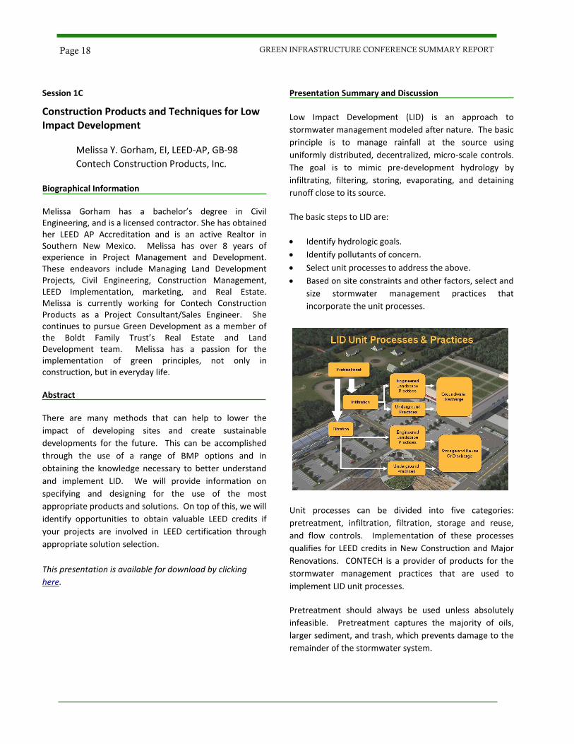
Unit processes can be divided into five categories:
pretreatment, infiltration, filtration, storage and reuse,
and flow controls. Implementation of these processes
qualifies for LEED credits in New Construction and Major
Renovations. CONTECH is a provider of products for the
stormwater management practices that are used to
implement LID unit processes.
Pretreatment should always be used unless absolutely
infeasible. Pretreatment captures the majority of oils,
larger sediment, and trash, which prevents damage to the
remainder of the stormwater system.
Page 18 GREEN INFRASTRUCTURE CONFERENCE SUMMARY REPORT
Infiltration and filtration help to reduce runoff volume, but
their most important function is to improve water quality
by removing pollutants of concern. Infiltration is the most
effective option, where feasible. Filtration is used where
infiltration is infeasible due to poor soil conditions, high
groundwater, proximity of foundations, or other site
constraints. Some sites may require a combination of the
two processes.
Infiltration may be accomplished through surface or
subsurface practices. Practices that facilitate infiltration
through the ground surface include pervious concrete,
grass and gravel pavers, geogrid, turf reinforcement mats,
and other permeable ground surface covers. Proper
design of the sub-base and sub-surface reinforcement is
essential to the effective operation and life-span of the
porous surface.
Underground infiltration methods are a cost-effective
solution in urbanized areas where land value is high or
space is not available for infiltration surfaces.
Underground infiltration practices are typically dry wells
and detention/retention devices, which collect
stormwater and allow it to infiltrate.
Filtration practices may be engineered landscapes or
underground structures. In engineered landscapes, tree
boxes and other types of planters are designed with media
specifically selected to filter stormwater and capture
pollutants. Underground filtration structures consist of a
treatment chamber through which stormwater flows.
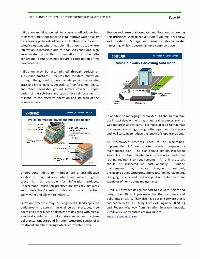
Storage and reuse of stormwater and flow controls are the
unit processes used to reduce runoff volume, peak flow,
and duration. Storage and reuse includes rainwater
harvesting, which is becoming more common place.
In addition to managing stormwater, LID should minimize
the impact development has on natural resources, such as
wetland areas and streams. Examples of tools to minimize
the impact are bridge designs that span sensitive areas
and wall systems to reduce the length of slope transitions.
All stormwater practices need to be maintained.
Implementing LID on a site includes preparing a
maintenance plan. The plan should contain inspection
schedules, routine maintenance procedures, and non-
routine maintenance requirements. All unit processes
should be inspected at least annually. Routine
maintenance may involve litter/debris removal,
unclogging outlet structures, and vegetation management.
Dredging, repairs, and media/vegetation replacement are
examples of non-routine maintenance.
CONTECH provides design support to evaluate, select and
design the LID unit processes for the hydrology and
pollutants on a site. They also have design software that is
compatible with U.S. Army Corps of Engineers (USACE)
and Federal Highway Administration hydraulic models.
CONTECH’s LID resources are available at:
www.contech-cpi.com.
Page 19 GREEN INFRASTRUCTURE CONFERENCE SUMMARY REPORT
Session 2A
Facilitating Affordable Green Infrastructure Retrofits: Developing Design Standards for Tucson, AZ
Catlow Shipek Watershed Management Group
Biographical Information
Catlow Shipek has consulted with engineering firms, city
departments, neighborhoods, businesses, and
organizations regarding green infrastructure design and
implementation. Catlow has led over 50 hands-on
workshops to engage residents in low cost and affordable
practices to improve the urban environment and build
community as well as providing instructional workshops
for environmental professionals through WMG’s Water
Harvesting Certification. Catlow has a Master’s Degree in
Watershed Management from the University of Arizona
and experience with erosion and sedimentation research
in southeastern Arizona’s rangelands.
Abstract
Neighborhoods, community leaders, and municipal
agencies are increasingly choosing green infrastructure
practices in place of conventional grey infrastructure.
Appropriately designed green infrastructure practices can
address a variety of neighborhood-scale issues including
stormwater, urban heat island, and community livability.
A general lack of experience with green infrastructure
practices in the southwestern semi-arid environment has
slowed the planning and design phases. Watershed
Management Group (WMG) recently developed a set of
green infrastructure design standards and conceptual
renderings in coordination with the City of Tucson. These
green infrastructure standards will facilitate a more
effective communication process during the planning and
design phases among neighborhood groups, engineers,
and municipal agencies to reduce potential roadblocks
and associated costs.
This presentation is available for download by clicking
here.
Presentation Summary and Discussion
WMG, a non-profit organization, started in Tucson, AZ
installing green infrastructure demonstration sites. The
organization has worked on small and large scale projects,
including community partnerships, co-ops, school yard
programs, and a green streets program. It has developed
a certification program for water harvesting that focuses
on the principles and how to apply them.
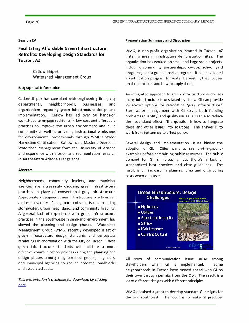
An integrated approach to green infrastructure addresses
many infrastructure issues faced by cities. GI can provide
lower-cost options for retrofitting “gray infrastructure.”
Stormwater management with GI solves both flooding
problems (quantity) and quality issues. GI can also reduce
the heat island effect. The question is how to integrate
these and other issues into solutions. The answer is to
work from bottom up to affect policy.
Several design and implementation issues hinder the
adoption of GI. Cities want to see on-the-ground-
examples before committing public resources. The public
demand for GI is increasing, but there’s a lack of
standardized best practices and clear guidelines. The
result is an increase in planning time and engineering
costs when GI is used.
All sorts of communication issues arise among
stakeholders when GI is implemented. Some
neighborhoods in Tucson have moved ahead with GI on
their own through permits from the City. The result is a
lot of different designs with different principles.
WMG obtained a grant to develop standard GI designs for
the arid southwest. The focus is to make GI practices
Page 20 GREEN INFRASTRUCTURE CONFERENCE SUMMARY REPORT
affordable and accessible. The designs are intended to be
simple, effective solutions that can be easily adapted to
site conditions. Designs are conceptual for residents and
community leaders. Catlow presented several examples,
including:
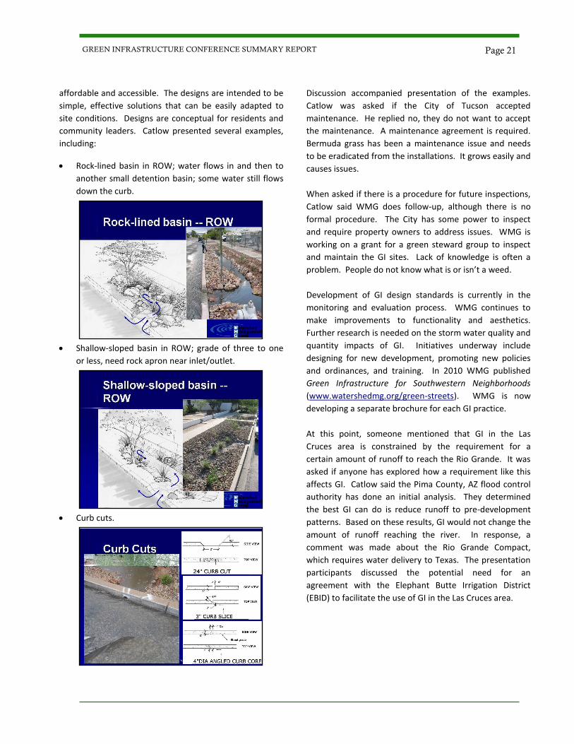
Rock-lined basin in ROW; water flows in and then to
another small detention basin; some water still flows
down the curb.
Shallow-sloped basin in ROW; grade of three to one
or less, need rock apron near inlet/outlet.
Curb cuts.
Discussion accompanied presentation of the examples.
Catlow was asked if the City of Tucson accepted
maintenance. He replied no, they do not want to accept
the maintenance. A maintenance agreement is required.
Bermuda grass has been a maintenance issue and needs
to be eradicated from the installations. It grows easily and
causes issues.
When asked if there is a procedure for future inspections,
Catlow said WMG does follow-up, although there is no
formal procedure. The City has some power to inspect
and require property owners to address issues. WMG is
working on a grant for a green steward group to inspect
and maintain the GI sites. Lack of knowledge is often a
problem. People do not know what is or isn’t a weed.
Development of GI design standards is currently in the
monitoring and evaluation process. WMG continues to
make improvements to functionality and aesthetics.
Further research is needed on the storm water quality and
quantity impacts of GI. Initiatives underway include
designing for new development, promoting new policies
and ordinances, and training. In 2010 WMG published
Green Infrastructure for Southwestern Neighborhoods
(www.watershedmg.org/green-streets). WMG is now
developing a separate brochure for each GI practice.
At this point, someone mentioned that GI in the Las
Cruces area is constrained by the requirement for a
certain amount of runoff to reach the Rio Grande. It was
asked if anyone has explored how a requirement like this
affects GI. Catlow said the Pima County, AZ flood control
authority has done an initial analysis. They determined
the best GI can do is reduce runoff to pre-development
patterns. Based on these results, GI would not change the
amount of runoff reaching the river. In response, a
comment was made about the Rio Grande Compact,
which requires water delivery to Texas. The presentation
participants discussed the potential need for an
agreement with the Elephant Butte Irrigation District
(EBID) to facilitate the use of GI in the Las Cruces area.
Page 21 GREEN INFRASTRUCTURE CONFERENCE SUMMARY REPORT
Session 2B
Integrated Community Planning:
Finding Ways to Do More with Less
Kevin Shepherd, PE
HDR Engineering, Inc.
Biographical Information
Kevin Shepherd has more than 15 years of experience
working with cities, counties, and other agencies in the
areas of project and program management, planning,
design, and construction for a wide variety of municipal
infrastructure improvement and development projects.
His experience includes municipal consulting,
sustainability and energy management, master planning,
roadway schematics and Plans, Specifications, and
Estimates (PS&E), general site civil design, public
involvement, program management, permitting, and
construction inspection/administration. He oversees
HDR’s emerging programs for energy management and
sustainability for the community sector and is actively
involved with organizations at the local, state, and federal
levels to track and implement legislation.
Abstract Many communities are looking to be more “green” to
recruit and retain businesses and residents. Legislation
and funding programs are encouraging GI/LID, energy
conservation, emissions reduction, and smart growth
principles. At the same time, the recession has cities
under pressure to do more with fewer resources. To
succeed in this environment, city departments must work
together to identify additional efficiencies that can only be
found when approaching things from a holistic and
interdisciplinary perspective. This presentation highlights
an approach and tools that are helping communities to
identify initiatives that help achieve sustainability goals
across departments and agencies; apply for and secure
federal funding; and implement projects ranging from
downtown redevelopment plans to ordinance and code
revisions to green infrastructure design and construction.
This presentation is available for download by clicking
here.
Presentation Summary and Discussion
Integrated Community Planning is an approach that guides
design and development of sustainable communities. The
shift from traditional to sustainable development is driven
by market trends. The trends are affected by the
recession, population growth, the rising cost of gas,
changes in climate and weather patterns, decreasing
availability of natural resources, regulatory requirements
that push green/sustainable development, and increasing
priority on resilience and redundancy so communities will
survive changing conditions.
Integrated stormwater management is an important part
of sustainable development and integrated planning.
However, communities must typically overcome many
obstacles to change from conventional to integrated
stormwater management. The challenges presented by
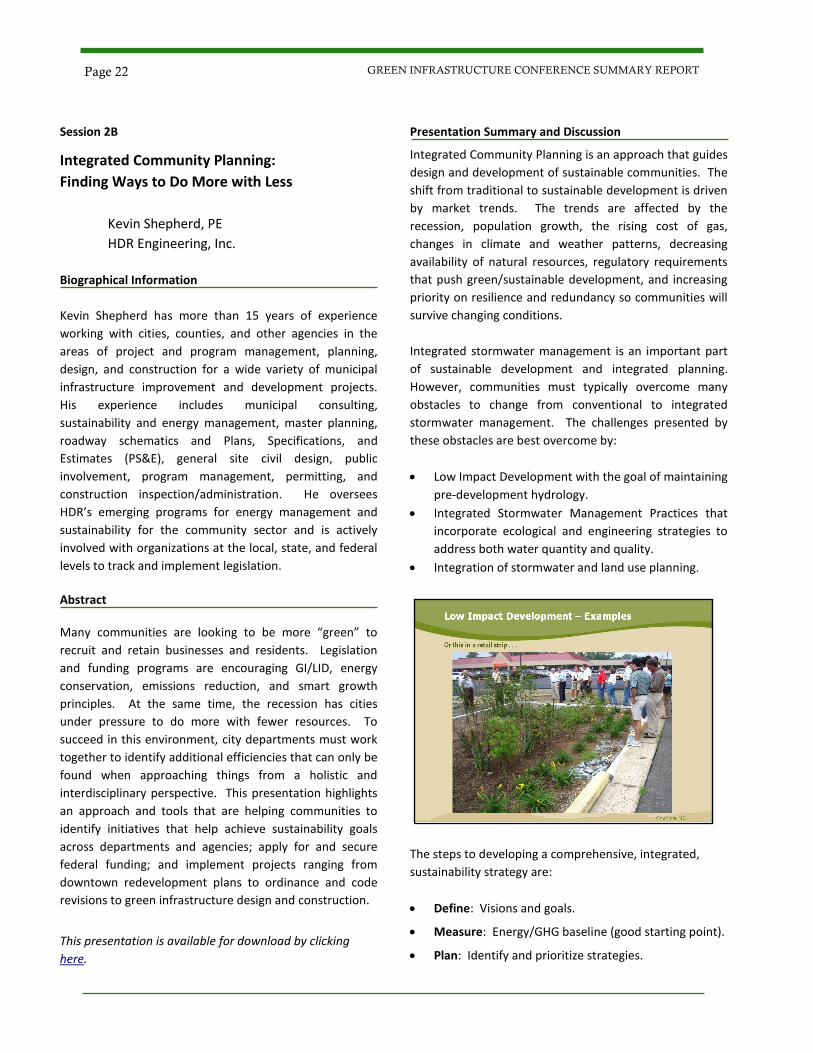
these obstacles are best overcome by:
Low Impact Development with the goal of maintaining
pre-development hydrology.
Integrated Stormwater Management Practices that
incorporate ecological and engineering strategies to
address both water quantity and quality.
Integration of stormwater and land use planning.
The steps to developing a comprehensive, integrated,
sustainability strategy are:
Define: Visions and goals.
Measure: Energy/GHG baseline (good starting point).
Plan: Identify and prioritize strategies.
Page 22 GREEN INFRASTRUCTURE CONFERENCE SUMMARY REPORT
Implement: Identify funding and partners to implement the plan.
Monitor and Report: Sustainability metrics towards meeting goals.
In HDR’s model, there are 12 elements of sustainable
communities: Air (Climate), Community, Culture, Energy,
Economy, Environment, Facilities, Land Use, Mobility,
Sustenance, Water, and Waste. The presentation includes
descriptions and examples for each of the 12 elements.
At this point in the presentation, participants raised the
topic of stimulus funding and asked if it worked to
encourage sustainability. Kevin replied that it has,
especially in the areas of energy conservation, renewable
alternatives, and transit. It has also increased
transparency in government, with all of the reporting and
other requirements that accompanied the funding. One
other benefit is an increase in regional partnerships and
collaboration. The Department of Transportation’s Tiger II
program and similar programs have gotten people to work
together and coordinate more effectively.
Current standards and ordinances can become obstacles
to Integrated Community Planning when they have not
been updated to address the methods of an integrated
approach. Another challenge is that many cities still
operate as separate departments, and don’t communicate
across department lines very well. The best way to
overcome these challenges is to get everyone together in
the same room to work together.
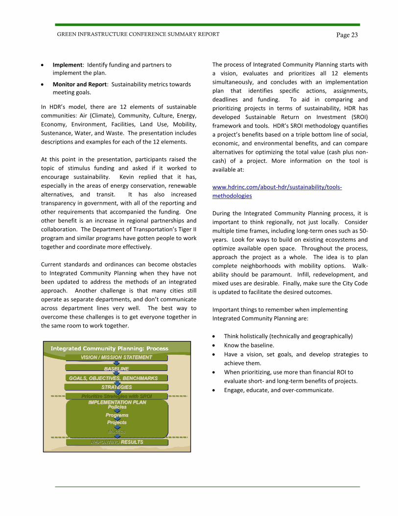
The process of Integrated Community Planning starts with
a vision, evaluates and prioritizes all 12 elements
simultaneously, and concludes with an implementation
plan that identifies specific actions, assignments,
deadlines and funding. To aid in comparing and
prioritizing projects in terms of sustainability, HDR has
developed Sustainable Return on Investment (SROI)
framework and tools. HDR’s SROI methodology quantifies
a project’s benefits based on a triple bottom line of social,
economic, and environmental benefits, and can compare
alternatives for optimizing the total value (cash plus non-
cash) of a project. More information on the tool is
available at:
www.hdrinc.com/about-hdr/sustainability/tools-
methodologies
During the Integrated Community Planning process, it is
important to think regionally, not just locally. Consider
multiple time frames, including long-term ones such as 50-
years. Look for ways to build on existing ecosystems and
optimize available open space. Throughout the process,
approach the project as a whole. The idea is to plan
complete neighborhoods with mobility options. Walk-
ability should be paramount. Infill, redevelopment, and
mixed uses are desirable. Finally, make sure the City Code
is updated to facilitate the desired outcomes.
Important things to remember when implementing
Integrated Community Planning are:
Think holistically (technically and geographically)
Know the baseline.
Have a vision, set goals, and develop strategies to
achieve them.
When prioritizing, use more than financial ROI to
evaluate short- and long-term benefits of projects.
Engage, educate, and over-communicate.
Page 23 GREEN INFRASTRUCTURE CONFERENCE SUMMARY REPORT
Session 2C
Ecological Restoration of the Rio Grande
Kevin Bixby
Southwest Environmental Center
Biographical Information
Kevin Bixby is the founder and Executive Director of the
Southwest Environmental Center (SWEC). The Center
works to protect and restore native wildlife and their
habitats in the Southwestern borderlands, through
advocacy, education, and on-the-ground projects. The
Center’s current campaigns focus on restoring the Rio
Grande, protecting Otero Mesa from oil and gas
development, and making sure Mexican wolves resume
their role as top predators in southwestern ecosystems.
Kevin lives in Las Cruces in a passive solar adobe house
that he and his family built.
Abstract
This presentation discusses current efforts to restore the
Rio Grande to ecological health using a “string of pearls”
approach that focuses on restoring separate nodes of
aquatic and riparian habitat located along a river reach,
rather than trying to restore its entire length. Specific
examples of how that approach is being implemented in
southern New Mexico are described, along with
challenges to ecological restoration posed by current
management of the river and tributaries for flood control.
The presentation also discusses whether or not
restoration and flood control are compatible.
This presentation is available for download by clicking
here.
Presentation Summary and Discussion
Wetlands are an essential part of the riparian ecosystem.
They store water, provide natural flood protection,
cleanse the water, recharge groundwater, control erosion,
and nurture all types of species. In the southwest,
wetlands comprise only 1% of the land area, yet at least
75% of southwestern vertebrate species depend on
wetlands for some or all of their life cycle.
The Rio Grande is the lifeline for over 500 vertebrate
species. Prior to 1870, the Rio Grande’s characteristics
were very different from today. Historically, it could be
characterized as:
Perennial flows (most years).
Peak flows—snow melt, summer rains.
Meandering, migrating channel.
Dynamic mosaic of plant communities.
Flooding as a key process.
Abundant fish and wildlife.
Wetlands estimated at 2% to 10% of floodplain.
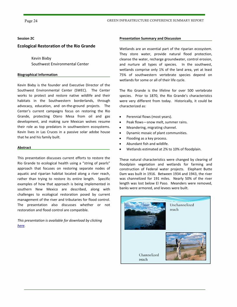
These natural characteristics were changed by clearing of floodplain vegetation and wetlands for farming and construction of Federal water projects. Elephant Butte Dam was built in 1916. Between 1934 and 1943, the river was channelized for 191 miles. Nearly 50% of the river length was lost below El Paso. Meanders were removed, banks were armored, and levees were built.
Page 24 GREEN INFRASTRUCTURE CONFERENCE SUMMARY REPORT
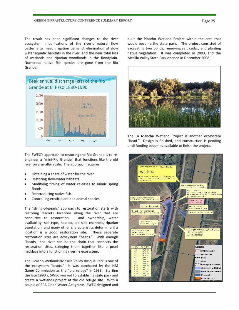
The result has been significant changes to the river ecosystem: modifications of the river’s natural flow patterns to meet irrigation demand; elimination of slow water aquatic habitats in the river; and the near total loss of wetlands and riparian woodlands in the floodplain. Numerous native fish species are gone from the Rio Grande.
The SWEC’s approach to restoring the Rio Grande is to re-engineer a “mini-Rio Grande” that functions like the old river on a smaller scale. The approach requires:
Obtaining a share of water for the river.
Restoring slow-water habitats.
Modifying timing of water releases to mimic spring floods.
Reintroducing native fish.
Controlling exotic plant and animal species. The “string-of-pearls” approach to restoration starts with restoring discrete locations along the river that are conducive to restoration. Land ownership, water availability, soil type, habitat, old side channels, riparian vegetation, and many other characteristics determine if a location is a good restoration site. These separate restoration sites are ecosystem “beads.” With enough “beads,” the river can be the chain that connects the restoration sites, stringing them together like a pearl necklace into a functioning riverine ecosystem. The Picacho Wetlands/Mesilla Valley Bosque Park is one of the ecosystem “beads.” It was purchased by the NM Game Commission as the “old refuge” in 1933. Starting the late 1990’s, SWEC worked to establish a state park and create a wetlands project at the old refuge site. With a couple of EPA Clean Water Act grants, SWEC designed and
built the Picacho Wetland Project within the area that would become the state park. The project consisted of excavating two ponds, removing salt cedar, and planting native vegetation. It was completed in 2003, and the Mesilla Valley State Park opened in December 2008.
The La Mancha Wetland Project is another ecosystem “bead.” Design is finished, and construction is pending until funding becomes available to finish the project.
Page 25 GREEN INFRASTRUCTURE CONFERENCE SUMMARY REPORT
Session 2C
Low Impact Development Measures for Protection of Groundwater
John T. Kay, PG
Daniel B. Stephens & Associates, Inc. Biographical Information
John Kay has 10 years of experience in water resource
assessments, field data collection, instrumentation, and
hydrologic investigations. He holds a BS degree in geology
from Northern Arizona University and an MS degree in
hydrology from The University of Arizona. John specializes
in vadose zone and near surface hydrologic processes,
including recharge monitoring/modeling, and surface
water-groundwater interactions. He has evaluated and
designed numerous LID features to mitigate the impacts of
urban development projects on groundwater. Currently,
John is overseeing a regulatory driven monitoring program
at a large private property in Malibu, CA, where complex
irrigation, LID, geotechnical stability, and storm runoff
issues are conjunctively managed to best protect the
entire hydrologic system.
Abstract
Low impact development (LID) features that rely on
capture and infiltration of stormwater are frequently
designed and implemented without taking subsurface
characteristics into consideration. As a result, these
features may fail over the long term or result in
degradation of groundwater quality. Incorporating
subsurface characteristics, including use of subsurface
monitoring and soil testing, can result in LID features that
enhance benefits to groundwater, achieve surface water
objectives, and have greater longevity. This presentation
discusses several unique methodologies that incorporate
subsurface characteristics into LID design.
This presentation is available for download by clicking
here.
Presentation Summary and Discussion
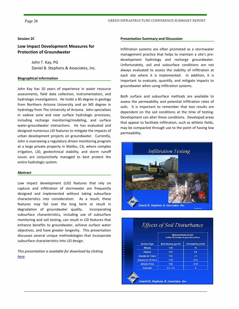
Infiltration systems are often promoted as a stormwater
management practice that helps to maintain a site’s pre-
development hydrology and recharge groundwater.
Unfortunately, soil and subsurface conditions are not
always evaluated to assess the viability of infiltration at
each site where it is implemented. In addition, it is
important to evaluate, quantify, and mitigate impacts to
groundwater when using infiltration systems.
Both surface and subsurface methods are available to
assess the permeability and potential infiltration rates of
soils. It is important to remember that test results are
dependent on the soil conditions at the time of testing.
Development can alter these conditions. Developed areas
that appear to facilitate infiltration, such as athletic fields,
may be compacted through use to the point of having low
permeability.
Page 26 GREEN INFRASTRUCTURE CONFERENCE SUMMARY REPORT
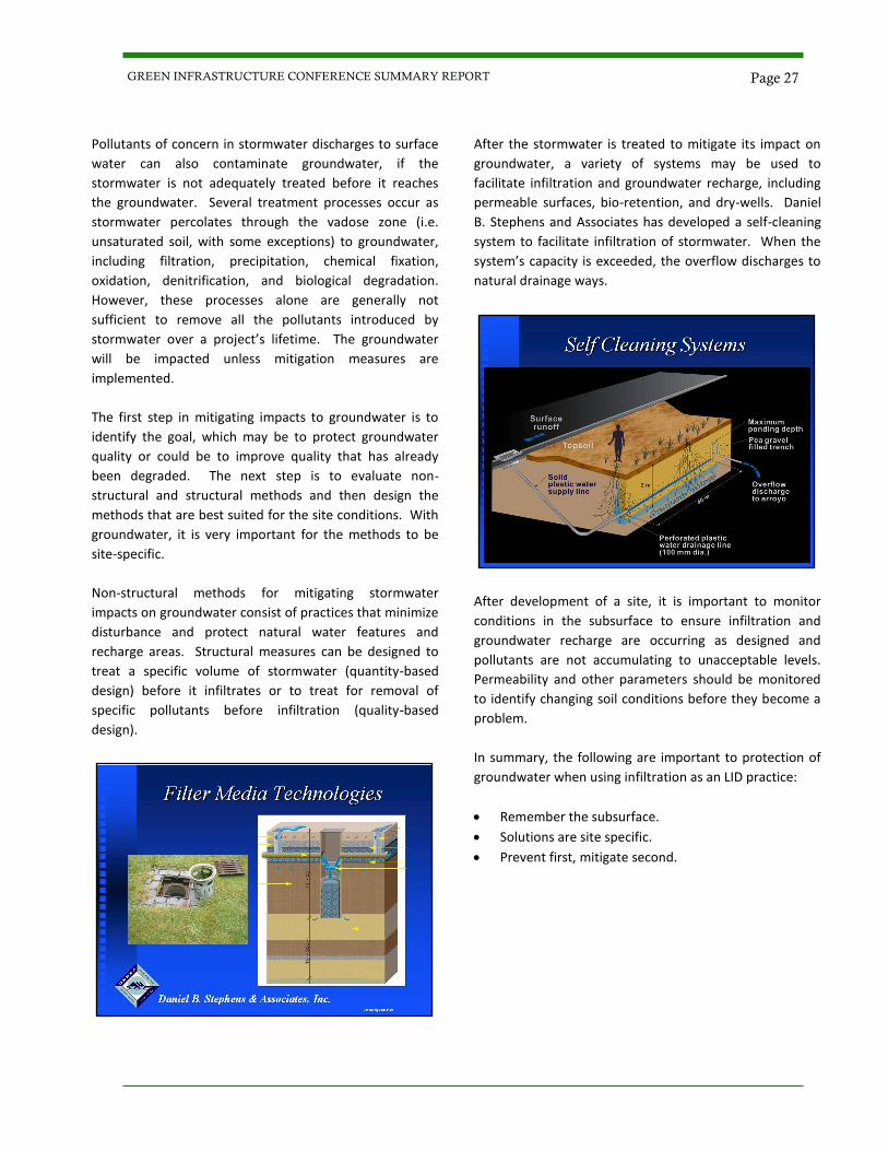
Pollutants of concern in stormwater discharges to surface
water can also contaminate groundwater, if the
stormwater is not adequately treated before it reaches
the groundwater. Several treatment processes occur as
stormwater percolates through the vadose zone (i.e.
unsaturated soil, with some exceptions) to groundwater,
including filtration, precipitation, chemical fixation,
oxidation, denitrification, and biological degradation.
However, these processes alone are generally not
sufficient to remove all the pollutants introduced by
stormwater over a project’s lifetime. The groundwater
will be impacted unless mitigation measures are
implemented.
The first step in mitigating impacts to groundwater is to
identify the goal, which may be to protect groundwater
quality or could be to improve quality that has already
been degraded. The next step is to evaluate non-
structural and structural methods and then design the
methods that are best suited for the site conditions. With
groundwater, it is very important for the methods to be
site-specific.
Non-structural methods for mitigating stormwater
impacts on groundwater consist of practices that minimize
disturbance and protect natural water features and
recharge areas. Structural measures can be designed to
treat a specific volume of stormwater (quantity-based
design) before it infiltrates or to treat for removal of
specific pollutants before infiltration (quality-based
design).
After the stormwater is treated to mitigate its impact on
groundwater, a variety of systems may be used to
facilitate infiltration and groundwater recharge, including
permeable surfaces, bio-retention, and dry-wells. Daniel
B. Stephens and Associates has developed a self-cleaning
system to facilitate infiltration of stormwater. When the
system’s capacity is exceeded, the overflow discharges to
natural drainage ways.
After development of a site, it is important to monitor
conditions in the subsurface to ensure infiltration and
groundwater recharge are occurring as designed and
pollutants are not accumulating to unacceptable levels.
Permeability and other parameters should be monitored
to identify changing soil conditions before they become a
problem.
In summary, the following are important to protection of
groundwater when using infiltration as an LID practice:
Remember the subsurface.
Solutions are site specific.
Prevent first, mitigate second.
Page 27 GREEN INFRASTRUCTURE CONFERENCE SUMMARY REPORT

Keynote
Low Impact Development and Green Infrastructure Pathways to Success
Neil Weinstein, PE, RLA, AICP
Low Impact Development Center, Inc. Biographical Information Neil Weinstein is the Executive Director and one of the
founders of the Low Impact Development (LID) Center,
Inc. Formed in 1998, the LID Center is a non-profit
organization that focuses on the research and
implementation of innovative and sustainable
infrastructure, stormwater, and water management
strategies and techniques. Neil helped develop the
original concepts and foundations of LID over 15 years
ago. He has worked across the country helping
communities to implement LID and Green Infrastructure.
Recently, he worked with EPA and the Department of
Defense on development of Section 438 of the Energy
Independence and Security Act. Neil was one of the
original signers of the Letter of Intent to develop Green
Infrastructure with EPA and is currently the Co-Chair of
the first national American Society of Civil Engineers
conference on Green Highways and Green Streets.
Abstract
This presentation shows how to address the many
complex challenges that communities encounter when
considering incorporating LID into their stormwater and
land development programs, with a focus on the
southwestern US. The attendee gains a perspective on the
best strategies to address the planning, regulatory,
political, community development, and financial
requirements of LID implementation through the
experience of the LID Center, which has worked on this
issue throughout the nation.
This presentation is available for download by clicking
here.
Presentation Summary and Discussion
In the last quarter of the 20th century, the rate of
development in the United States was more than twice
the rate of the population growth. One quarter of all
development was constructed between 1982 and 1997.
The conventional drainage controls for most of this
development were based on collecting, concentrating, and
conveying stormwater runoff in a centralized, controlled
manner. Design criteria focused on reducing the peak
discharge flow rate, while failing to address the increased
volume of stormwater runoff generated by development.
Watershed hydrology was largely ignored.
The result has been a negative effect on the waters
receiving the stormwater runoff. Approximately 40% of
assessed waters do not meet Water Quality Standards.
Despite stormwater regulations and billions spent on
water quality projects, water quality is virtually unchanged
since the Clean Water Act was passed in 1972. During this
period, Best Management Practices (BMPs) required by
regulations have primarily been end-of-pipe controls.
The results show that end-of-pipe controls have not been
effective in reducing the water quality impacts of
stormwater runoff. Therefore, the focus of BMPs has
shifted to source controls in recent years. LID is an
important tool for treating stormwater at its source. In
addition, the benefits of LID extend beyond stormwater
management and include environmental, economic, and
community benefits. One example is the reduction in heat
island effect, which in turn reduces energy demand for
Page 28 GREEN INFRASTRUCTURE CONFERENCE SUMMARY REPORT
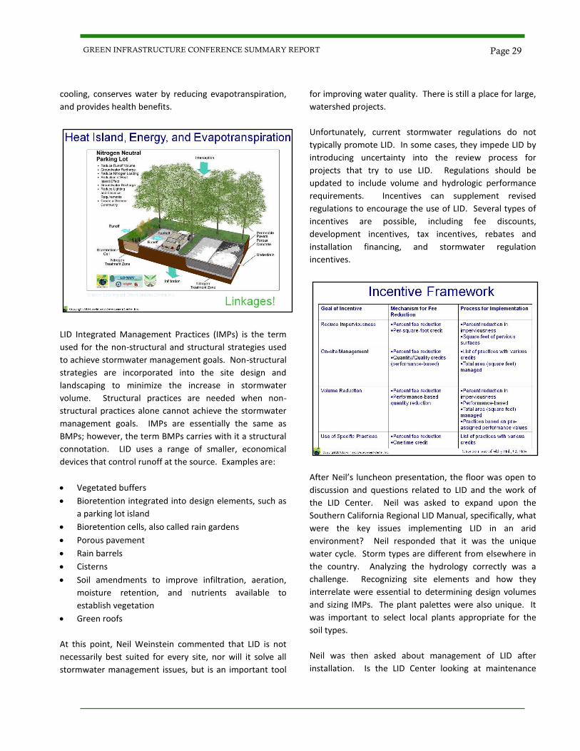
cooling, conserves water by reducing evapotranspiration,
and provides health benefits.
LID Integrated Management Practices (IMPs) is the term
used for the non-structural and structural strategies used
to achieve stormwater management goals. Non-structural
strategies are incorporated into the site design and
landscaping to minimize the increase in stormwater
volume. Structural practices are needed when non-
structural practices alone cannot achieve the stormwater
management goals. IMPs are essentially the same as
BMPs; however, the term BMPs carries with it a structural
connotation. LID uses a range of smaller, economical
devices that control runoff at the source. Examples are:
Vegetated buffers
Bioretention integrated into design elements, such as
a parking lot island
Bioretention cells, also called rain gardens
Porous pavement
Rain barrels
Cisterns
Soil amendments to improve infiltration, aeration,
moisture retention, and nutrients available to
establish vegetation
Green roofs
At this point, Neil Weinstein commented that LID is not
necessarily best suited for every site, nor will it solve all
stormwater management issues, but is an important tool
for improving water quality. There is still a place for large,
watershed projects.
Unfortunately, current stormwater regulations do not
typically promote LID. In some cases, they impede LID by
introducing uncertainty into the review process for
projects that try to use LID. Regulations should be
updated to include volume and hydrologic performance
requirements. Incentives can supplement revised
regulations to encourage the use of LID. Several types of
incentives are possible, including fee discounts,
development incentives, tax incentives, rebates and
installation financing, and stormwater regulation
incentives.
After Neil’s luncheon presentation, the floor was open to
discussion and questions related to LID and the work of
the LID Center. Neil was asked to expand upon the
Southern California Regional LID Manual, specifically, what
were the key issues implementing LID in an arid
environment? Neil responded that it was the unique
water cycle. Storm types are different from elsewhere in
the country. Analyzing the hydrology correctly was a
challenge. Recognizing site elements and how they
interrelate were essential to determining design volumes
and sizing IMPs. The plant palettes were also unique. It
was important to select local plants appropriate for the
soil types.
Neil was then asked about management of LID after
installation. Is the LID Center looking at maintenance
Page 29 GREEN INFRASTRUCTURE CONFERENCE SUMMARY REPORT
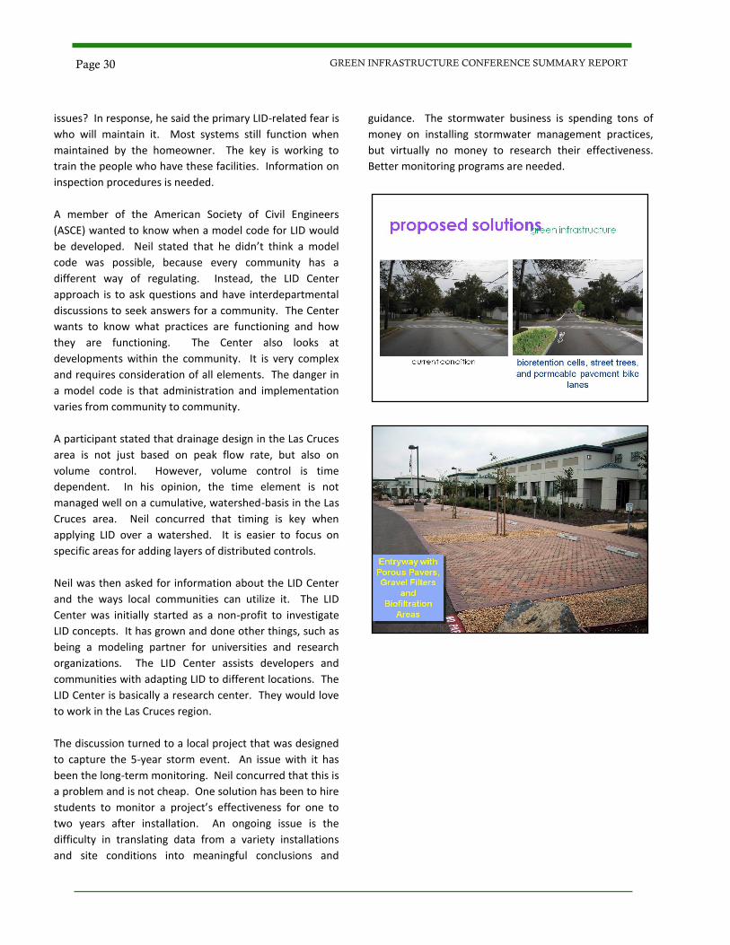
issues? In response, he said the primary LID-related fear is
who will maintain it. Most systems still function when
maintained by the homeowner. The key is working to
train the people who have these facilities. Information on
inspection procedures is needed.
A member of the American Society of Civil Engineers
(ASCE) wanted to know when a model code for LID would
be developed. Neil stated that he didn’t think a model
code was possible, because every community has a
different way of regulating. Instead, the LID Center
approach is to ask questions and have interdepartmental
discussions to seek answers for a community. The Center
wants to know what practices are functioning and how
they are functioning. The Center also looks at
developments within the community. It is very complex
and requires consideration of all elements. The danger in
a model code is that administration and implementation
varies from community to community.
A participant stated that drainage design in the Las Cruces
area is not just based on peak flow rate, but also on
volume control. However, volume control is time
dependent. In his opinion, the time element is not
managed well on a cumulative, watershed-basis in the Las
Cruces area. Neil concurred that timing is key when
applying LID over a watershed. It is easier to focus on
specific areas for adding layers of distributed controls.
Neil was then asked for information about the LID Center
and the ways local communities can utilize it. The LID
Center was initially started as a non-profit to investigate
LID concepts. It has grown and done other things, such as
being a modeling partner for universities and research
organizations. The LID Center assists developers and
communities with adapting LID to different locations. The
LID Center is basically a research center. They would love
to work in the Las Cruces region.
The discussion turned to a local project that was designed
to capture the 5-year storm event. An issue with it has
been the long-term monitoring. Neil concurred that this is
a problem and is not cheap. One solution has been to hire
students to monitor a project’s effectiveness for one to
two years after installation. An ongoing issue is the
difficulty in translating data from a variety installations
and site conditions into meaningful conclusions and
guidance. The stormwater business is spending tons of
money on installing stormwater management practices,
but virtually no money to research their effectiveness.
Better monitoring programs are needed.
Page 30 GREEN INFRASTRUCTURE CONFERENCE SUMMARY REPORT
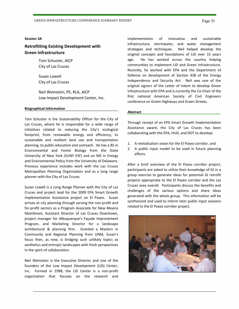
Session 3A
Retrofitting Existing Development with
Green Infrastructure
Tom Schuster, AICP
City of Las Cruces
Susan Lowell
City of Las Cruces
Neil Weinstein, PE, RLA, AICP
Low Impact Development Center, Inc.
Biographical Information
Tom Schuster is the Sustainability Officer for the City of
Las Cruces, where he is responsible for a wide range of
initiatives related to reducing the City’s ecological
footprint, from renewable energy and efficiency, to
sustainable and resilient land use and transportation
planning, to public education and outreach. He has a BS in
Environmental and Forest Biology from the State
University of New York (SUNY ESF) and an MS in Energy
and Environmental Policy from the University of Delaware.
Previous experience includes work with the Las Cruces
Metropolitan Planning Organization and as a long range
planner with the City of Las Cruces.
Susan Lowell is a Long Range Planner with the City of Las
Cruces and project lead for the 2009 EPA Smart Growth
Implementation Assistance project on El Paseo. Susan
arrives at city planning through serving the non-profit and
for-profit sectors as a Program Associate for New Mexico
MainStreet, Assistant Director of Las Cruces Downtown,
project manager for Albuquerque’s Façade Improvement
Program, and Marketing Director for a landscape
architectural & planning firm. Granted a Masters in
Community and Regional Planning from UNM, Susan’s
focus then, as now, is bridging such unlikely topics as
aesthetics and entropic landscapes with fresh perspectives
in the spirit of collaboration.
Neil Weinstein is the Executive Director and one of the
founders of the Low Impact Development (LID) Center,
Inc. Formed in 1998, the LID Center is a non-profit
organization that focuses on the research and
implementation of innovative and sustainable
infrastructure, stormwater, and water management
strategies and techniques. Neil helped develop the
original concepts and foundations of LID over 15 years
ago. He has worked across the country helping
communities to implement LID and Green Infrastructure.
Recently, he worked with EPA and the Department of
Defense on development of Section 438 of the Energy
Independence and Security Act. Neil was one of the
original signers of the Letter of Intent to develop Green
Infrastructure with EPA and is currently the Co-Chair of the
first national American Society of Civil Engineers
conference on Green Highways and Green Streets.
Abstract
Through receipt of an EPA Smart Growth Implementation
Assistance award, the City of Las Cruces has been
collaborating with the EPA, HUD, and DOT to develop:
1. A revitalization vision for the El Paseo corridor, and
2. A public input model to be used in future planning
efforts.
After a brief overview of the El Paseo corridor project,
participants are asked to utilize their knowledge of GI in a
group exercise to generate ideas for potential GI retrofit
projects appropriate to the El Paseo corridor and the Las
Cruces area overall. Participants discuss the benefits and
challenges of the various options and share ideas
generated with the whole group. This information will be
synthesized and used to inform later public input sessions
related to the El Paseo corridor project.
Page 31 GREEN INFRASTRUCTURE CONFERENCE SUMMARY REPORT
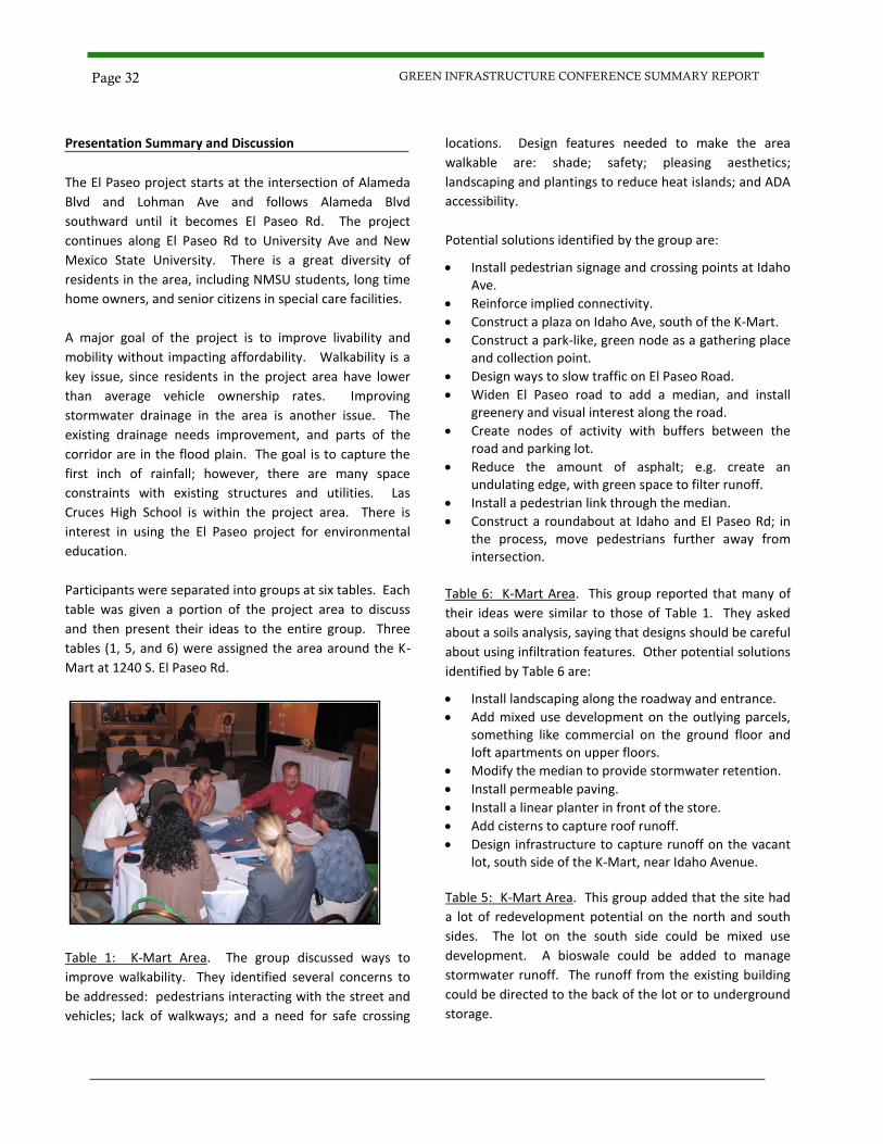
Presentation Summary and Discussion
The El Paseo project starts at the intersection of Alameda
Blvd and Lohman Ave and follows Alameda Blvd
southward until it becomes El Paseo Rd. The project
continues along El Paseo Rd to University Ave and New
Mexico State University. There is a great diversity of
residents in the area, including NMSU students, long time
home owners, and senior citizens in special care facilities.
A major goal of the project is to improve livability and
mobility without impacting affordability. Walkability is a
key issue, since residents in the project area have lower
than average vehicle ownership rates. Improving
stormwater drainage in the area is another issue. The
existing drainage needs improvement, and parts of the
corridor are in the flood plain. The goal is to capture the
first inch of rainfall; however, there are many space
constraints with existing structures and utilities. Las
Cruces High School is within the project area. There is
interest in using the El Paseo project for environmental
education.
Participants were separated into groups at six tables. Each
table was given a portion of the project area to discuss
and then present their ideas to the entire group. Three
tables (1, 5, and 6) were assigned the area around the K-
Mart at 1240 S. El Paseo Rd.
Table 1: K-Mart Area. The group discussed ways to
improve walkability. They identified several concerns to
be addressed: pedestrians interacting with the street and
vehicles; lack of walkways; and a need for safe crossing
locations. Design features needed to make the area
walkable are: shade; safety; pleasing aesthetics;
landscaping and plantings to reduce heat islands; and ADA
accessibility.
Potential solutions identified by the group are:
Install pedestrian signage and crossing points at Idaho Ave.
Reinforce implied connectivity.
Construct a plaza on Idaho Ave, south of the K-Mart.
Construct a park-like, green node as a gathering place and collection point.
Design ways to slow traffic on El Paseo Road.
Widen El Paseo road to add a median, and install greenery and visual interest along the road.
Create nodes of activity with buffers between the road and parking lot.
Reduce the amount of asphalt; e.g. create an undulating edge, with green space to filter runoff.
Install a pedestrian link through the median.
Construct a roundabout at Idaho and El Paseo Rd; in the process, move pedestrians further away from intersection.
Table 6: K-Mart Area. This group reported that many of
their ideas were similar to those of Table 1. They asked
about a soils analysis, saying that designs should be careful
about using infiltration features. Other potential solutions
identified by Table 6 are:
Install landscaping along the roadway and entrance.
Add mixed use development on the outlying parcels, something like commercial on the ground floor and loft apartments on upper floors.
Modify the median to provide stormwater retention.
Install permeable paving.
Install a linear planter in front of the store.
Add cisterns to capture roof runoff.
Design infrastructure to capture runoff on the vacant lot, south side of the K-Mart, near Idaho Avenue.
Table 5: K-Mart Area. This group added that the site had
a lot of redevelopment potential on the north and south
sides. The lot on the south side could be mixed use
development. A bioswale could be added to manage
stormwater runoff. The runoff from the existing building
could be directed to the back of the lot or to underground
storage.
Page 32 GREEN INFRASTRUCTURE CONFERENCE SUMMARY REPORT
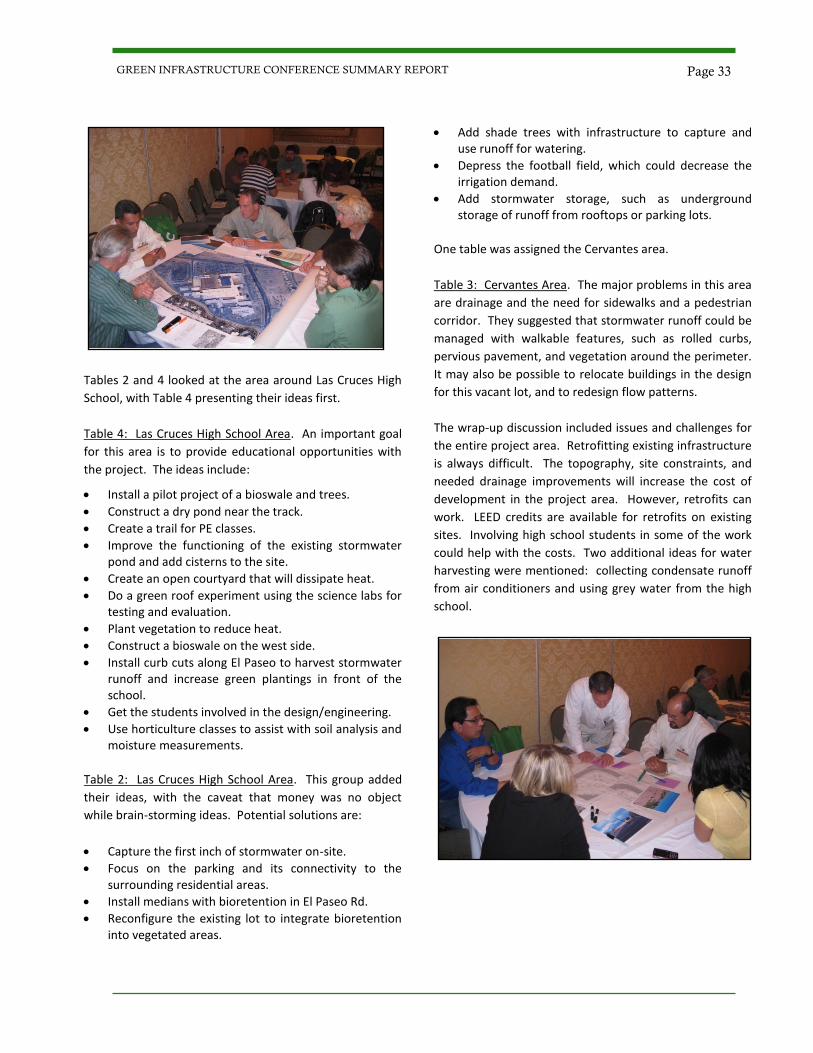
Tables 2 and 4 looked at the area around Las Cruces High
School, with Table 4 presenting their ideas first.
Table 4: Las Cruces High School Area. An important goal
for this area is to provide educational opportunities with
the project. The ideas include:
Install a pilot project of a bioswale and trees.
Construct a dry pond near the track.
Create a trail for PE classes.
Improve the functioning of the existing stormwater pond and add cisterns to the site.
Create an open courtyard that will dissipate heat.
Do a green roof experiment using the science labs for testing and evaluation.
Plant vegetation to reduce heat.
Construct a bioswale on the west side.
Install curb cuts along El Paseo to harvest stormwater runoff and increase green plantings in front of the school.
Get the students involved in the design/engineering.
Use horticulture classes to assist with soil analysis and moisture measurements.
Table 2: Las Cruces High School Area. This group added
their ideas, with the caveat that money was no object
while brain-storming ideas. Potential solutions are:
Capture the first inch of stormwater on-site.
Focus on the parking and its connectivity to the surrounding residential areas.
Install medians with bioretention in El Paseo Rd.
Reconfigure the existing lot to integrate bioretention into vegetated areas.
Add shade trees with infrastructure to capture and use runoff for watering.
Depress the football field, which could decrease the irrigation demand.
Add stormwater storage, such as underground storage of runoff from rooftops or parking lots.
One table was assigned the Cervantes area.
Table 3: Cervantes Area. The major problems in this area
are drainage and the need for sidewalks and a pedestrian
corridor. They suggested that stormwater runoff could be
managed with walkable features, such as rolled curbs,
pervious pavement, and vegetation around the perimeter.
It may also be possible to relocate buildings in the design
for this vacant lot, and to redesign flow patterns.
The wrap-up discussion included issues and challenges for
the entire project area. Retrofitting existing infrastructure
is always difficult. The topography, site constraints, and
needed drainage improvements will increase the cost of
development in the project area. However, retrofits can
work. LEED credits are available for retrofits on existing
sites. Involving high school students in some of the work
could help with the costs. Two additional ideas for water
harvesting were mentioned: collecting condensate runoff
from air conditioners and using grey water from the high
school.
Page 33 GREEN INFRASTRUCTURE CONFERENCE SUMMARY REPORT
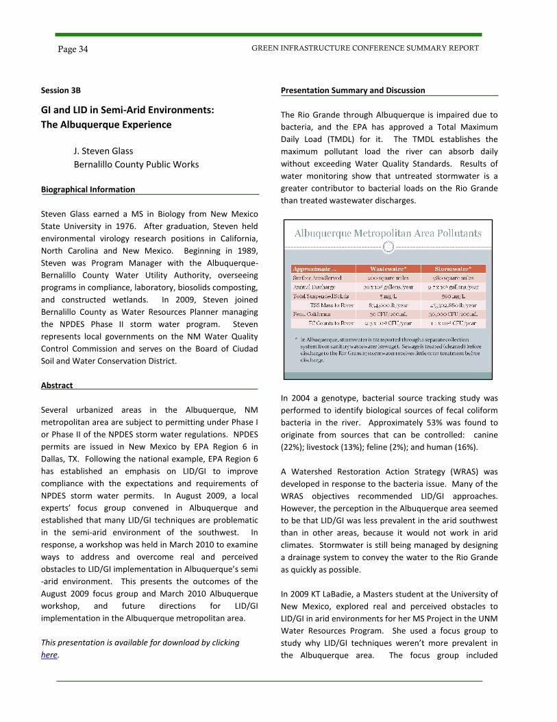
Session 3B
GI and LID in Semi-Arid Environments:
The Albuquerque Experience
J. Steven Glass
Bernalillo County Public Works
Biographical Information
Steven Glass earned a MS in Biology from New Mexico
State University in 1976. After graduation, Steven held
environmental virology research positions in California,
North Carolina and New Mexico. Beginning in 1989,
Steven was Program Manager with the Albuquerque-
Bernalillo County Water Utility Authority, overseeing
programs in compliance, laboratory, biosolids composting,
and constructed wetlands. In 2009, Steven joined
Bernalillo County as Water Resources Planner managing
the NPDES Phase II storm water program. Steven
represents local governments on the NM Water Quality
Control Commission and serves on the Board of Ciudad
Soil and Water Conservation District.
Abstract
Several urbanized areas in the Albuquerque, NM
metropolitan area are subject to permitting under Phase I
or Phase II of the NPDES storm water regulations. NPDES
permits are issued in New Mexico by EPA Region 6 in
Dallas, TX. Following the national example, EPA Region 6
has established an emphasis on LID/GI to improve
compliance with the expectations and requirements of
NPDES storm water permits. In August 2009, a local
experts’ focus group convened in Albuquerque and
established that many LID/GI techniques are problematic
in the semi-arid environment of the southwest. In
response, a workshop was held in March 2010 to examine
ways to address and overcome real and perceived
obstacles to LID/GI implementation in Albuquerque’s semi
-arid environment. This presents the outcomes of the
August 2009 focus group and March 2010 Albuquerque
workshop, and future directions for LID/GI
implementation in the Albuquerque metropolitan area.
This presentation is available for download by clicking
here.
Presentation Summary and Discussion
The Rio Grande through Albuquerque is impaired due to
bacteria, and the EPA has approved a Total Maximum
Daily Load (TMDL) for it. The TMDL establishes the
maximum pollutant load the river can absorb daily
without exceeding Water Quality Standards. Results of
water monitoring show that untreated stormwater is a
greater contributor to bacterial loads on the Rio Grande
than treated wastewater discharges.
In 2004 a genotype, bacterial source tracking study was
performed to identify biological sources of fecal coliform
bacteria in the river. Approximately 53% was found to
originate from sources that can be controlled: canine
(22%); livestock (13%); feline (2%); and human (16%).
A Watershed Restoration Action Strategy (WRAS) was
developed in response to the bacteria issue. Many of the
WRAS objectives recommended LID/GI approaches.
However, the perception in the Albuquerque area seemed
to be that LID/GI was less prevalent in the arid southwest
than in other areas, because it would not work in arid
climates. Stormwater is still being managed by designing
a drainage system to convey the water to the Rio Grande
as quickly as possible.
In 2009 KT LaBadie, a Masters student at the University of
New Mexico, explored real and perceived obstacles to
LID/GI in arid environments for her MS Project in the UNM
Water Resources Program. She used a focus group to
study why LID/GI techniques weren’t more prevalent in
the Albuquerque area. The focus group included
Page 34 GREEN INFRASTRUCTURE CONFERENCE SUMMARY REPORT
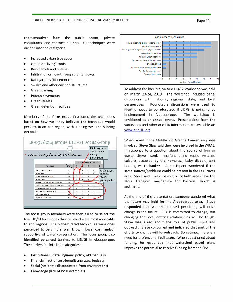
representatives from the public sector, private
consultants, and contract builders. GI techniques were
divided into ten categories:
Increased urban tree cover
Green or “living” roofs
Rain barrels and cisterns
Infiltration or flow-through planter boxes
Rain gardens (bioretention)
Swales and other earthen structures
Green parking
Porous pavements
Green streets
Green detention facilities
Members of the focus group first rated the techniques
based on how well they believed the technique would
perform in an arid region, with 1 being well and 5 being
not well.
The focus group members were then asked to select the
four LID/GI techniques they believed were most applicable
to arid regions. The highest rated techniques were ones
perceived to be simple, well known, lower cost, and/or
supportive of water conservation. The focus group also
identified perceived barriers to LID/GI in Albuquerque.
The barriers fell into four categories:
Institutional (State Engineer policy, old manuals)
Financial (lack of cost-benefit analyses, budgets)
Social (residents disconnected from environment)
Knowledge (lack of local examples)
To address the barriers, an Arid LID/GI Workshop was held
on March 23-24, 2010. The workshop included panel
discussions with national, regional, state, and local
perspectives. Roundtable discussions were used to
identify needs to be addressed if LID/GI is going to be
implemented in Albuquerque. The workshop is
envisioned as an annual event. Presentations from the
workshops and other arid LID information are available at:
www.aridLID.org.
When asked if the Middle Rio Grande Conservancy was
involved, Steve Glass said they were involved in the WRAS.
In response to a question about the source of human
waste, Steve listed: malfunctioning septic systems,
culverts occupied by the homeless, baby diapers, and
bootleg waste haulers. A participant wondered if the
same sources/problems could be present in the Las Cruces
area. Steve said it was possible, since both areas have the
same transport mechanism for bacteria, which is
sediment.
At the end of the presentation, someone pondered what
the future may hold for the Albuquerque area. Steve
responded that watershed-based permitting will drive
change in the future. EPA is committed to change, but
changing the local entities relationships will be tough.
Steve was asked about the role of public input and
outreach. Steve concurred and indicated that part of the
efforts to change will be outreach. Sometimes, there is a
need for professional facilitators. When questioned about
funding, he responded that watershed based plans
improve the potential to receive funding from the EPA.
Page 35 GREEN INFRASTRUCTURE CONFERENCE SUMMARY REPORT
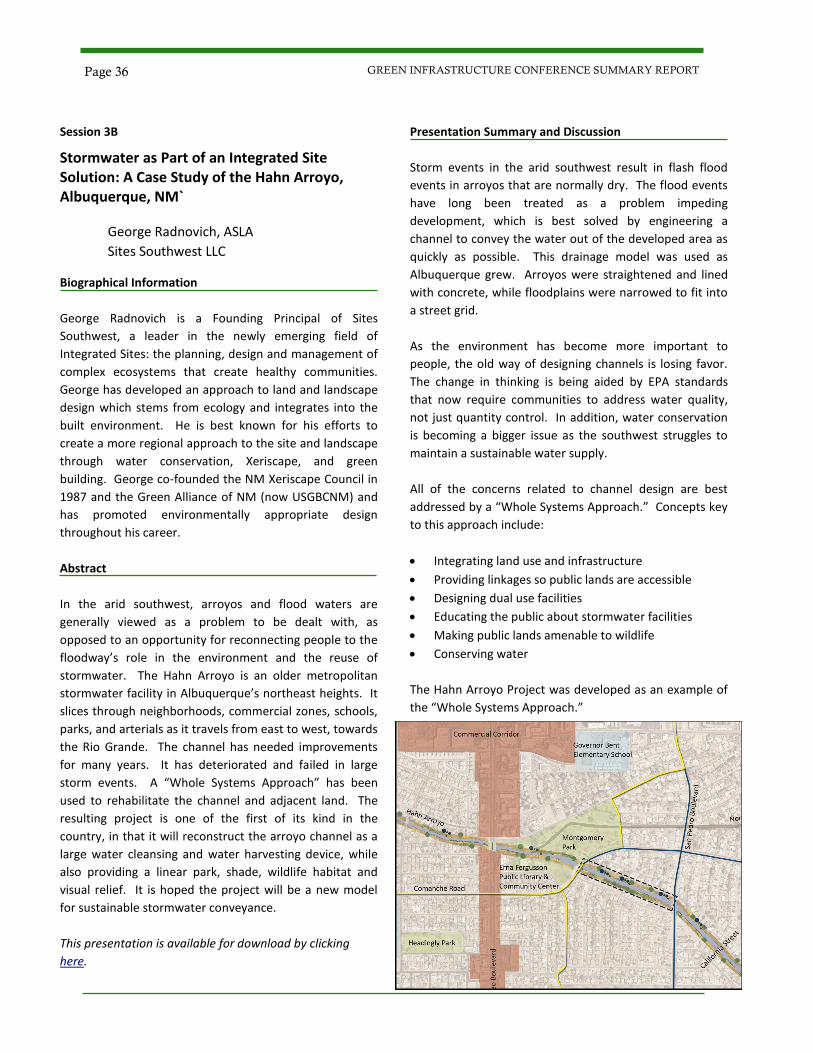
Session 3B
Stormwater as Part of an Integrated Site Solution: A Case Study of the Hahn Arroyo, Albuquerque, NM`
George Radnovich, ASLA
Sites Southwest LLC
Biographical Information
George Radnovich is a Founding Principal of Sites
Southwest, a leader in the newly emerging field of
Integrated Sites: the planning, design and management of
complex ecosystems that create healthy communities.
George has developed an approach to land and landscape
design which stems from ecology and integrates into the
built environment. He is best known for his efforts to
create a more regional approach to the site and landscape
through water conservation, Xeriscape, and green
building. George co-founded the NM Xeriscape Council in
1987 and the Green Alliance of NM (now USGBCNM) and
has promoted environmentally appropriate design
throughout his career.
Abstract
In the arid southwest, arroyos and flood waters are
generally viewed as a problem to be dealt with, as
opposed to an opportunity for reconnecting people to the
floodway’s role in the environment and the reuse of
stormwater. The Hahn Arroyo is an older metropolitan
stormwater facility in Albuquerque’s northeast heights. It
slices through neighborhoods, commercial zones, schools,
parks, and arterials as it travels from east to west, towards
the Rio Grande. The channel has needed improvements
for many years. It has deteriorated and failed in large
storm events. A “Whole Systems Approach” has been
used to rehabilitate the channel and adjacent land. The
resulting project is one of the first of its kind in the
country, in that it will reconstruct the arroyo channel as a
large water cleansing and water harvesting device, while
also providing a linear park, shade, wildlife habitat and
visual relief. It is hoped the project will be a new model
for sustainable stormwater conveyance.
This presentation is available for download by clicking
here.
Presentation Summary and Discussion
Storm events in the arid southwest result in flash flood
events in arroyos that are normally dry. The flood events
have long been treated as a problem impeding
development, which is best solved by engineering a
channel to convey the water out of the developed area as
quickly as possible. This drainage model was used as
Albuquerque grew. Arroyos were straightened and lined
with concrete, while floodplains were narrowed to fit into
a street grid.
As the environment has become more important to
people, the old way of designing channels is losing favor.
The change in thinking is being aided by EPA standards
that now require communities to address water quality,
not just quantity control. In addition, water conservation
is becoming a bigger issue as the southwest struggles to
maintain a sustainable water supply.
All of the concerns related to channel design are best
addressed by a “Whole Systems Approach.” Concepts key
to this approach include:
Integrating land use and infrastructure
Providing linkages so public lands are accessible
Designing dual use facilities
Educating the public about stormwater facilities
Making public lands amenable to wildlife
Conserving water
The Hahn Arroyo Project was developed as an example of
the “Whole Systems Approach.”
Page 36 GREEN INFRASTRUCTURE CONFERENCE SUMMARY REPORT
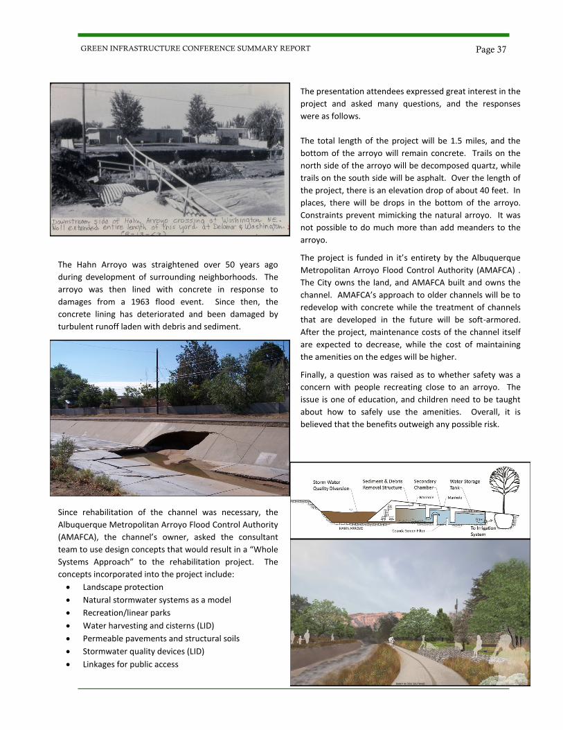
The Hahn Arroyo was straightened over 50 years ago
during development of surrounding neighborhoods. The
arroyo was then lined with concrete in response to
damages from a 1963 flood event. Since then, the
concrete lining has deteriorated and been damaged by
turbulent runoff laden with debris and sediment.
Since rehabilitation of the channel was necessary, the
Albuquerque Metropolitan Arroyo Flood Control Authority
(AMAFCA), the channel’s owner, asked the consultant
team to use design concepts that would result in a “Whole
Systems Approach” to the rehabilitation project. The
concepts incorporated into the project include:
Landscape protection
Natural stormwater systems as a model
Recreation/linear parks
Water harvesting and cisterns (LID)
Permeable pavements and structural soils
Stormwater quality devices (LID)
Linkages for public access
The presentation attendees expressed great interest in the
project and asked many questions, and the responses
were as follows.
The total length of the project will be 1.5 miles, and the
bottom of the arroyo will remain concrete. Trails on the
north side of the arroyo will be decomposed quartz, while
trails on the south side will be asphalt. Over the length of
the project, there is an elevation drop of about 40 feet. In
places, there will be drops in the bottom of the arroyo.
Constraints prevent mimicking the natural arroyo. It was
not possible to do much more than add meanders to the
arroyo.
The project is funded in it’s entirety by the Albuquerque
Metropolitan Arroyo Flood Control Authority (AMAFCA) .
The City owns the land, and AMAFCA built and owns the
channel. AMAFCA’s approach to older channels will be to
redevelop with concrete while the treatment of channels
that are developed in the future will be soft-armored.
After the project, maintenance costs of the channel itself
are expected to decrease, while the cost of maintaining
the amenities on the edges will be higher.
Finally, a question was raised as to whether safety was a
concern with people recreating close to an arroyo. The
issue is one of education, and children need to be taught
about how to safely use the amenities. Overall, it is
believed that the benefits outweigh any possible risk.
Page 37 GREEN INFRASTRUCTURE CONFERENCE SUMMARY REPORT
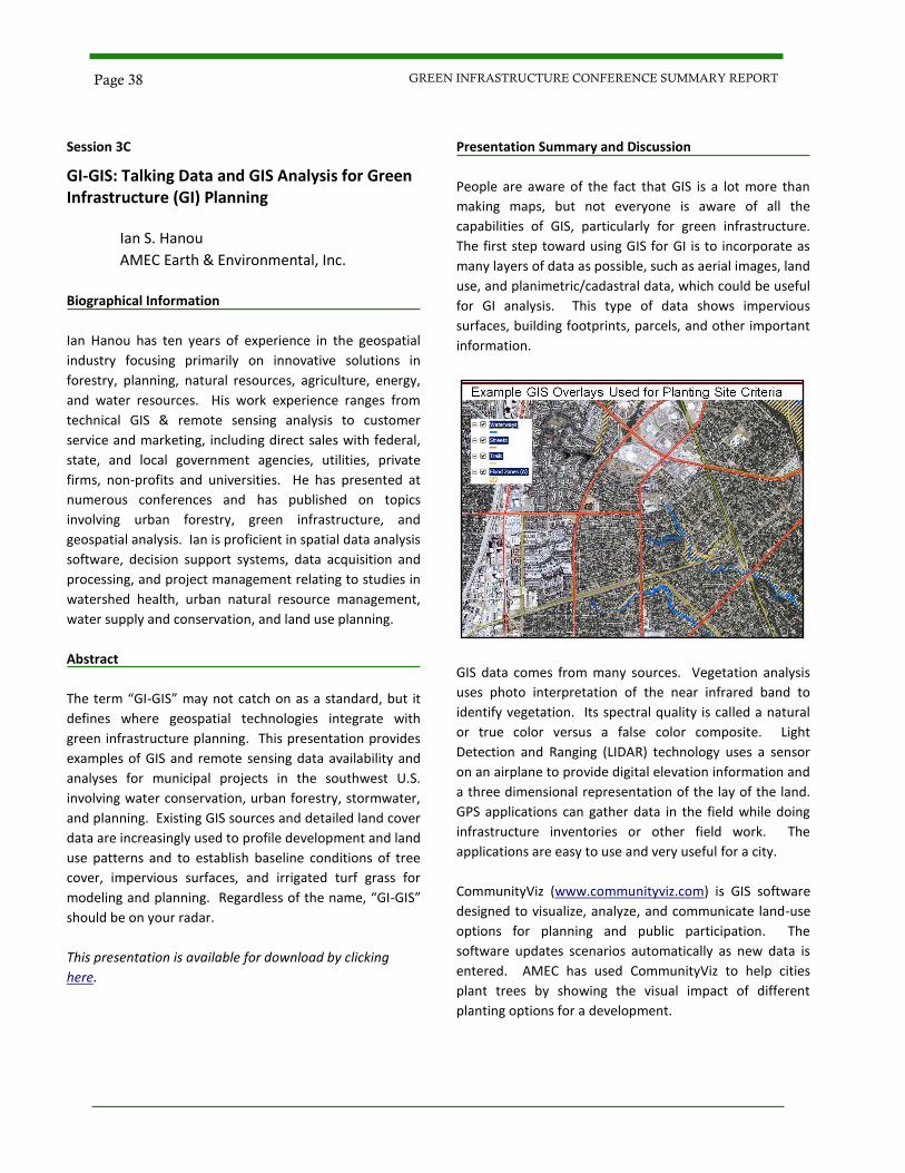
Session 3C
GI-GIS: Talking Data and GIS Analysis for Green Infrastructure (GI) Planning
Ian S. Hanou
AMEC Earth & Environmental, Inc.
Biographical Information
Ian Hanou has ten years of experience in the geospatial
industry focusing primarily on innovative solutions in
forestry, planning, natural resources, agriculture, energy,
and water resources. His work experience ranges from
technical GIS & remote sensing analysis to customer
service and marketing, including direct sales with federal,
state, and local government agencies, utilities, private
firms, non-profits and universities. He has presented at
numerous conferences and has published on topics
involving urban forestry, green infrastructure, and
geospatial analysis. Ian is proficient in spatial data analysis
software, decision support systems, data acquisition and
processing, and project management relating to studies in
watershed health, urban natural resource management,
water supply and conservation, and land use planning.
Abstract
The term “GI-GIS” may not catch on as a standard, but it
defines where geospatial technologies integrate with
green infrastructure planning. This presentation provides
examples of GIS and remote sensing data availability and
analyses for municipal projects in the southwest U.S.
involving water conservation, urban forestry, stormwater,
and planning. Existing GIS sources and detailed land cover
data are increasingly used to profile development and land
use patterns and to establish baseline conditions of tree
cover, impervious surfaces, and irrigated turf grass for
modeling and planning. Regardless of the name, “GI-GIS”
should be on your radar.
This presentation is available for download by clicking
here.
Presentation Summary and Discussion
People are aware of the fact that GIS is a lot more than
making maps, but not everyone is aware of all the
capabilities of GIS, particularly for green infrastructure.
The first step toward using GIS for GI is to incorporate as
many layers of data as possible, such as aerial images, land
use, and planimetric/cadastral data, which could be useful
for GI analysis. This type of data shows impervious
surfaces, building footprints, parcels, and other important
information.
GIS data comes from many sources. Vegetation analysis
uses photo interpretation of the near infrared band to
identify vegetation. Its spectral quality is called a natural
or true color versus a false color composite. Light
Detection and Ranging (LIDAR) technology uses a sensor
on an airplane to provide digital elevation information and
a three dimensional representation of the lay of the land.
GPS applications can gather data in the field while doing
infrastructure inventories or other field work. The
applications are easy to use and very useful for a city.
CommunityViz (www.communityviz.com) is GIS software
designed to visualize, analyze, and communicate land-use
options for planning and public participation. The
software updates scenarios automatically as new data is
entered. AMEC has used CommunityViz to help cities
plant trees by showing the visual impact of different
planting options for a development.
Page 38 GREEN INFRASTRUCTURE CONFERENCE SUMMARY REPORT
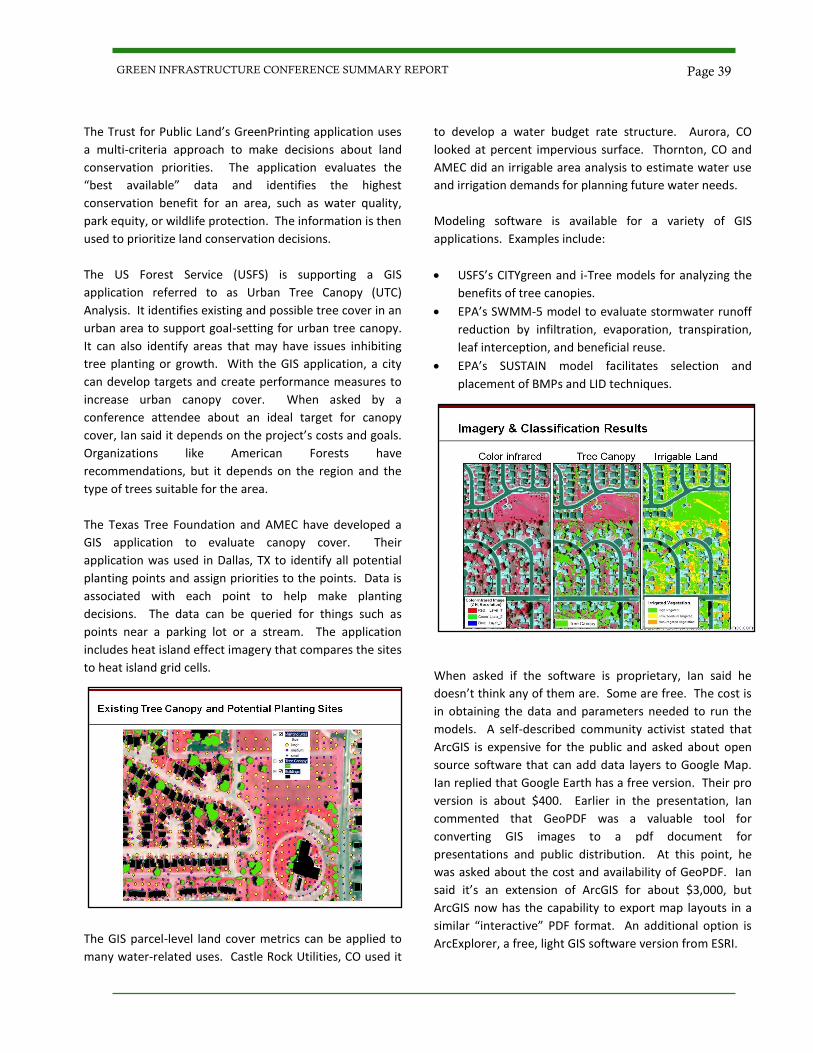
The Trust for Public Land’s GreenPrinting application uses
a multi-criteria approach to make decisions about land
conservation priorities. The application evaluates the
“best available” data and identifies the highest
conservation benefit for an area, such as water quality,
park equity, or wildlife protection. The information is then
used to prioritize land conservation decisions.
The US Forest Service (USFS) is supporting a GIS
application referred to as Urban Tree Canopy (UTC)
Analysis. It identifies existing and possible tree cover in an
urban area to support goal-setting for urban tree canopy.
It can also identify areas that may have issues inhibiting
tree planting or growth. With the GIS application, a city
can develop targets and create performance measures to
increase urban canopy cover. When asked by a
conference attendee about an ideal target for canopy
cover, Ian said it depends on the project’s costs and goals.
Organizations like American Forests have
recommendations, but it depends on the region and the
type of trees suitable for the area.
The Texas Tree Foundation and AMEC have developed a
GIS application to evaluate canopy cover. Their
application was used in Dallas, TX to identify all potential
planting points and assign priorities to the points. Data is
associated with each point to help make planting
decisions. The data can be queried for things such as
points near a parking lot or a stream. The application
includes heat island effect imagery that compares the sites
to heat island grid cells.
The GIS parcel-level land cover metrics can be applied to
many water-related uses. Castle Rock Utilities, CO used it
to develop a water budget rate structure. Aurora, CO
looked at percent impervious surface. Thornton, CO and
AMEC did an irrigable area analysis to estimate water use
and irrigation demands for planning future water needs.
Modeling software is available for a variety of GIS
applications. Examples include:
USFS’s CITYgreen and i-Tree models for analyzing the
benefits of tree canopies.
EPA’s SWMM-5 model to evaluate stormwater runoff
reduction by infiltration, evaporation, transpiration,
leaf interception, and beneficial reuse.
EPA’s SUSTAIN model facilitates selection and
placement of BMPs and LID techniques.
When asked if the software is proprietary, Ian said he
doesn’t think any of them are. Some are free. The cost is
in obtaining the data and parameters needed to run the
models. A self-described community activist stated that
ArcGIS is expensive for the public and asked about open
source software that can add data layers to Google Map.
Ian replied that Google Earth has a free version. Their pro
version is about $400. Earlier in the presentation, Ian
commented that GeoPDF was a valuable tool for
converting GIS images to a pdf document for
presentations and public distribution. At this point, he
was asked about the cost and availability of GeoPDF. Ian
said it’s an extension of ArcGIS for about $3,000, but
ArcGIS now has the capability to export map layouts in a
similar “interactive” PDF format. An additional option is
ArcExplorer, a free, light GIS software version from ESRI.
Page 39 GREEN INFRASTRUCTURE CONFERENCE SUMMARY REPORT
Session 4A
Panel Discussion: GI/LID and Local Government
Jeff Mann, Parametrix
Loretta Reyes, PE, City of Las Cruces
Peter Bennett, CFM, City of Las Cruces
Robert Armijo, PE, Doña Ana County
Kareem Dallo, PE, CFM, City of El Paso Biographical Information
Jeff Mann of Parametrix has broad-based planning
experience through his 31 years of involvement on a wide
range of land use planning and public involvement
projects. His experience has involved comprehensive land
use planning, master plan development, infrastructure
master plans, and environmental analysis. He has
processed projects in jurisdictions which were developing
Low Impact Development standards and has worked
through the tradeoffs and engineering adjustments
needed to accommodate green infrastructure in the
engineering review process. Jeff recently has been
involved in the public involvement and environmental
documentation for several road development projects for
the New Mexico Department of Transportation. He has a
Master of Environmental Administration from the
University of California Riverside and a B.S. in
Environmental Studies from the University of California,
Santa Barbara.
Loretta Reyes is the Engineering Services Administrator for
the City of Las Cruces, Public Works Department. Loretta
has been with the City for 16 years and has managed the
Engineering Services section for the past nine years. Her
duties are to ensure that development meets the City of
Las Cruces Design Standards and to ensure the proper
administration of the City of Las Cruces National Flood
Insurance Program, Community Rating System Program,
and the City of Las Cruces Storm Water Management
Program. Additionally, Loretta administers the
development, management, and maintenance of City
codes, design standards, specifications, and technical/
engineering services agreements, including development
and management of various engineering projects. Prior to
her tenure at the City, Loretta worked at the Los Angeles
Department of Water and Power for seven years, where
she managed the transportation of hazardous wastes and
materials, coordinated hazardous waste minimization
programs, planned and scoped major water utility
projects, and designed water trunk lines. Loretta holds a
Bachelor of Science degree in Civil Engineering from New
Mexico State University.
Peter Bennett is a Senior Engineering Technician for the
City of Las Cruces, Public Works Department, in the
Engineering Services section. Peter has managed the City
of Las Cruces Stormwater National Pollutant Discharge
Elimination System (NPDES), Phase II General Permit for
over three years and is a Certified Floodplain Manager
with the State of New Mexico. Peter is also an executive
committee member for the Paso del Norte Watershed
Council, which is part of the 319(h) Nonpoint Source Grant
involving various stakeholders within the stretch of the
lower Rio Grande watershed. Peter is a graduate of New
Mexico State University.
Robert Armijo is currently serving as the County Engineer
for Doña Ana County, a position he has held for almost
eight years. His duties include administration and
management of the Surveying, Design, Construction,
Inspection, Compliance Review, and Storm Water
Management sections of the Doña Ana County
Engineering Department. Robert is a New Mexico State
University graduate with over 14 years in the civil
engineering field in both the private and local government
sectors.
Kareem Dallo is the Engineering Division Manager for the
City of El Paso, a position he has held since 2005. His
duties are to insure the safety and the welfare of the
public in the development of existing and proposed
infrastructure by enforcing appropriate City Code,
Ordinances, Design Standards, Building Code, and
Environmental and Safety Regulations, as well as
administer the FEMA Flood Plain and Storm Water
Management Program. He has bachelors and masters
degrees in civil engineering from UTEP and a bachelor in
business administration from American University of
Beirut. He has over 25 years experience in the civil
engineering field.
Page 40 GREEN INFRASTRUCTURE CONFERENCE SUMMARY REPORT
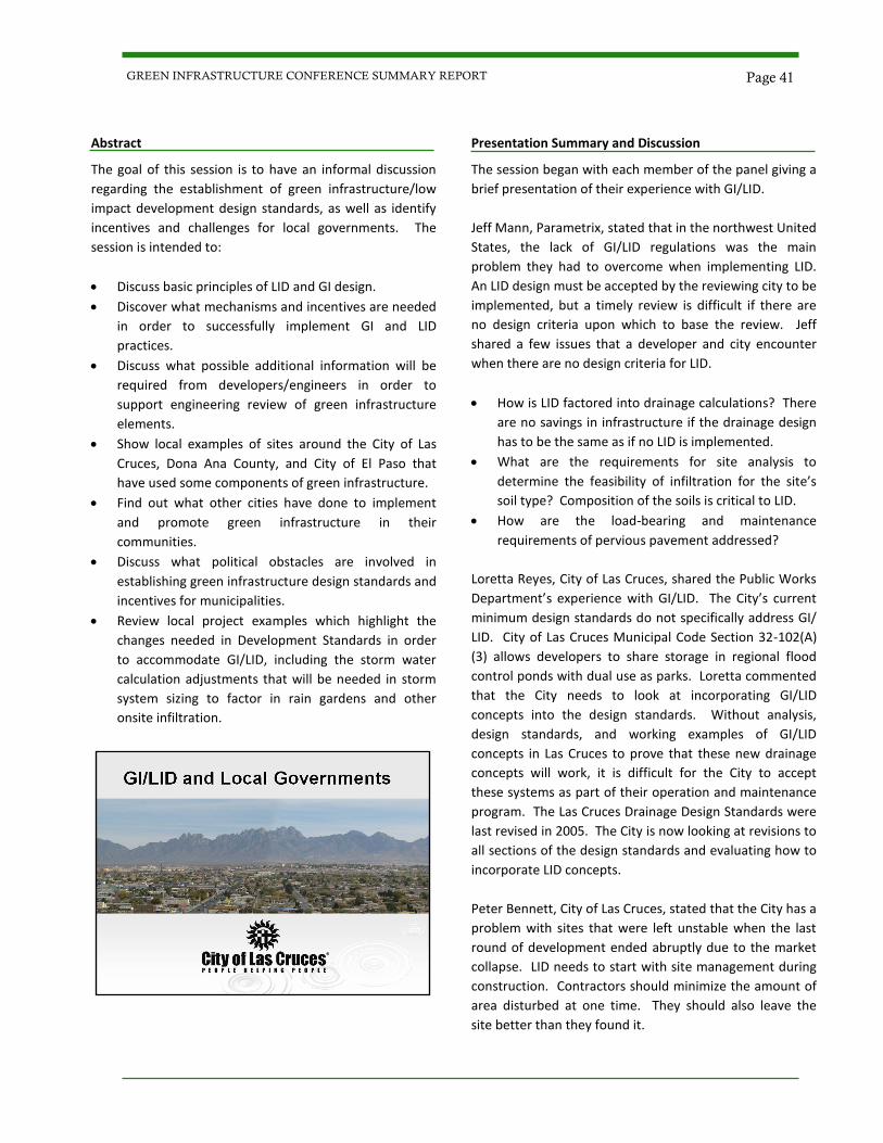
Abstract
The goal of this session is to have an informal discussion
regarding the establishment of green infrastructure/low
impact development design standards, as well as identify
incentives and challenges for local governments. The
session is intended to:
Discuss basic principles of LID and GI design.
Discover what mechanisms and incentives are needed
in order to successfully implement GI and LID
practices.
Discuss what possible additional information will be
required from developers/engineers in order to
support engineering review of green infrastructure
elements.
Show local examples of sites around the City of Las
Cruces, Dona Ana County, and City of El Paso that
have used some components of green infrastructure.
Find out what other cities have done to implement
and promote green infrastructure in their
communities.
Discuss what political obstacles are involved in
establishing green infrastructure design standards and
incentives for municipalities.
Review local project examples which highlight the
changes needed in Development Standards in order
to accommodate GI/LID, including the storm water
calculation adjustments that will be needed in storm
system sizing to factor in rain gardens and other
onsite infiltration.
Presentation Summary and Discussion
The session began with each member of the panel giving a
brief presentation of their experience with GI/LID.
Jeff Mann, Parametrix, stated that in the northwest United
States, the lack of GI/LID regulations was the main
problem they had to overcome when implementing LID.
An LID design must be accepted by the reviewing city to be
implemented, but a timely review is difficult if there are
no design criteria upon which to base the review. Jeff
shared a few issues that a developer and city encounter
when there are no design criteria for LID.
How is LID factored into drainage calculations? There
are no savings in infrastructure if the drainage design
has to be the same as if no LID is implemented.
What are the requirements for site analysis to
determine the feasibility of infiltration for the site’s
soil type? Composition of the soils is critical to LID.
How are the load-bearing and maintenance
requirements of pervious pavement addressed?
Loretta Reyes, City of Las Cruces, shared the Public Works
Department’s experience with GI/LID. The City’s current
minimum design standards do not specifically address GI/
LID. City of Las Cruces Municipal Code Section 32-102(A)
(3) allows developers to share storage in regional flood
control ponds with dual use as parks. Loretta commented
that the City needs to look at incorporating GI/LID
concepts into the design standards. Without analysis,
design standards, and working examples of GI/LID
concepts in Las Cruces to prove that these new drainage
concepts will work, it is difficult for the City to accept
these systems as part of their operation and maintenance
program. The Las Cruces Drainage Design Standards were
last revised in 2005. The City is now looking at revisions to
all sections of the design standards and evaluating how to
incorporate LID concepts.
Peter Bennett, City of Las Cruces, stated that the City has a
problem with sites that were left unstable when the last
round of development ended abruptly due to the market
collapse. LID needs to start with site management during
construction. Contractors should minimize the amount of
area disturbed at one time. They should also leave the
site better than they found it.
Page 41 GREEN INFRASTRUCTURE CONFERENCE SUMMARY REPORT
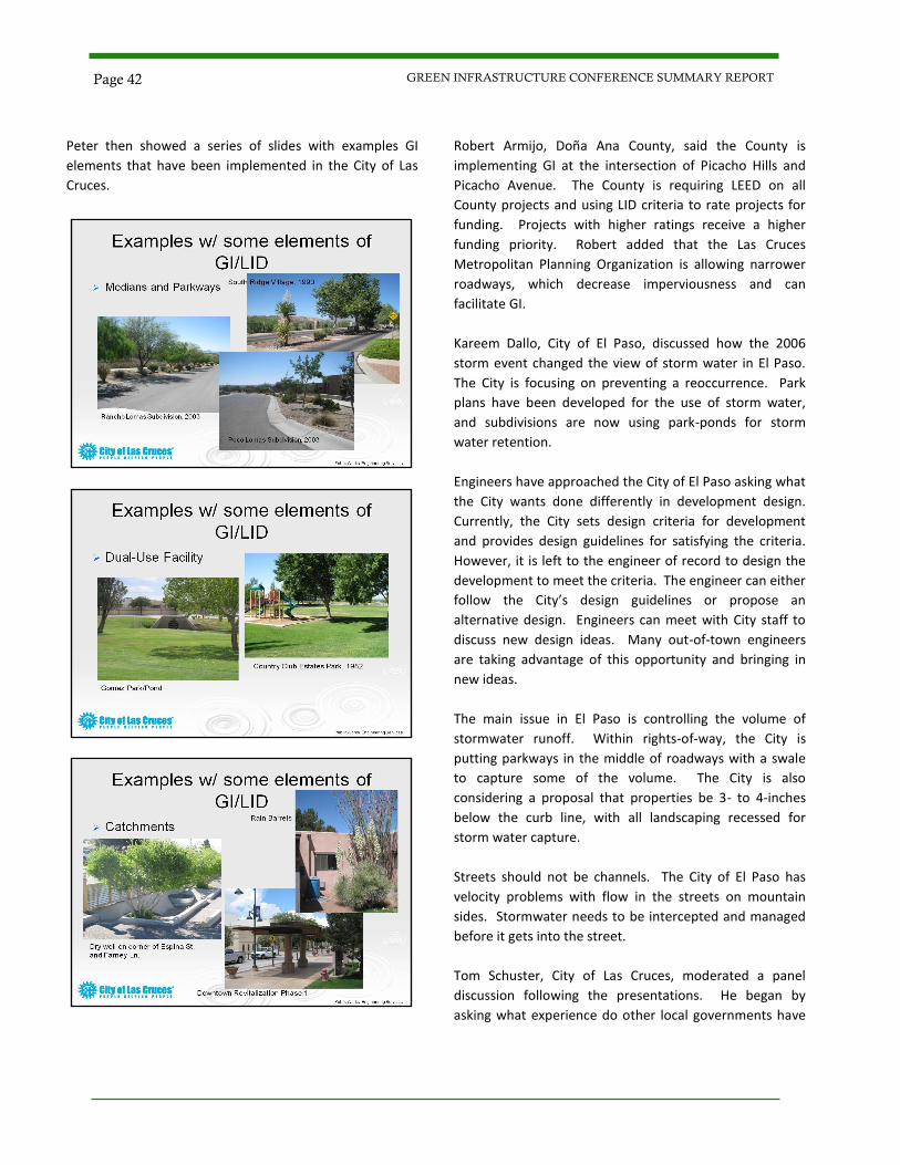
Peter then showed a series of slides with examples GI
elements that have been implemented in the City of Las
Cruces.
Robert Armijo, Doña Ana County, said the County is
implementing GI at the intersection of Picacho Hills and
Picacho Avenue. The County is requiring LEED on all
County projects and using LID criteria to rate projects for
funding. Projects with higher ratings receive a higher
funding priority. Robert added that the Las Cruces
Metropolitan Planning Organization is allowing narrower
roadways, which decrease imperviousness and can
facilitate GI.
Kareem Dallo, City of El Paso, discussed how the 2006
storm event changed the view of storm water in El Paso.
The City is focusing on preventing a reoccurrence. Park
plans have been developed for the use of storm water,
and subdivisions are now using park-ponds for storm
water retention.
Engineers have approached the City of El Paso asking what
the City wants done differently in development design.
Currently, the City sets design criteria for development
and provides design guidelines for satisfying the criteria.
However, it is left to the engineer of record to design the
development to meet the criteria. The engineer can either
follow the City’s design guidelines or propose an
alternative design. Engineers can meet with City staff to
discuss new design ideas. Many out-of-town engineers
are taking advantage of this opportunity and bringing in
new ideas.
The main issue in El Paso is controlling the volume of
stormwater runoff. Within rights-of-way, the City is
putting parkways in the middle of roadways with a swale
to capture some of the volume. The City is also
considering a proposal that properties be 3- to 4-inches
below the curb line, with all landscaping recessed for
storm water capture.
Streets should not be channels. The City of El Paso has
velocity problems with flow in the streets on mountain
sides. Stormwater needs to be intercepted and managed
before it gets into the street.
Tom Schuster, City of Las Cruces, moderated a panel
discussion following the presentations. He began by
asking what experience do other local governments have
Page 42 GREEN INFRASTRUCTURE CONFERENCE SUMMARY REPORT
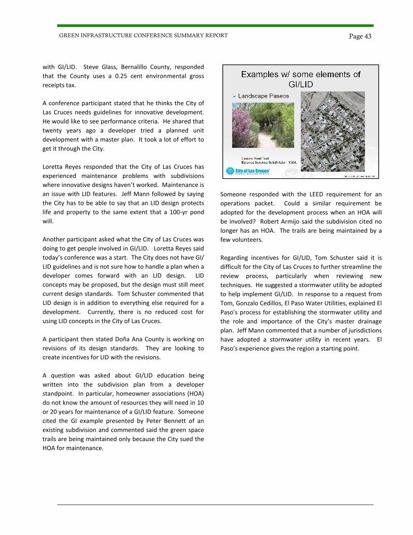
with GI/LID. Steve Glass, Bernalillo County, responded
that the County uses a 0.25 cent environmental gross
receipts tax.
A conference participant stated that he thinks the City of
Las Cruces needs guidelines for innovative development.
He would like to see performance criteria. He shared that
twenty years ago a developer tried a planned unit
development with a master plan. It took a lot of effort to
get it through the City.
Loretta Reyes responded that the City of Las Cruces has
experienced maintenance problems with subdivisions
where innovative designs haven’t worked. Maintenance is
an issue with LID features. Jeff Mann followed by saying
the City has to be able to say that an LID design protects
life and property to the same extent that a 100-yr pond
will.
Another participant asked what the City of Las Cruces was
doing to get people involved in GI/LID. Loretta Reyes said
today’s conference was a start. The City does not have GI/
LID guidelines and is not sure how to handle a plan when a
developer comes forward with an LID design. LID
concepts may be proposed, but the design must still meet
current design standards. Tom Schuster commented that
LID design is in addition to everything else required for a
development. Currently, there is no reduced cost for
using LID concepts in the City of Las Cruces.
A participant then stated Doña Ana County is working on
revisions of its design standards. They are looking to
create incentives for LID with the revisions.
A question was asked about GI/LID education being
written into the subdivision plan from a developer
standpoint. In particular, homeowner associations (HOA)
do not know the amount of resources they will need in 10
or 20 years for maintenance of a GI/LID feature. Someone
cited the GI example presented by Peter Bennett of an
existing subdivision and commented said the green space
trails are being maintained only because the City sued the
HOA for maintenance.
Someone responded with the LEED requirement for an
operations packet. Could a similar requirement be
adopted for the development process when an HOA will
be involved? Robert Armijo said the subdivision cited no
longer has an HOA. The trails are being maintained by a
few volunteers.
Regarding incentives for GI/LID, Tom Schuster said it is
difficult for the City of Las Cruces to further streamline the
review process, particularly when reviewing new
techniques. He suggested a stormwater utility be adopted
to help implement GI/LID. In response to a request from
Tom, Gonzalo Cedillos, El Paso Water Utilities, explained El
Paso’s process for establishing the stormwater utility and
the role and importance of the City’s master drainage
plan. Jeff Mann commented that a number of jurisdictions
have adopted a stormwater utility in recent years. El
Paso’s experience gives the region a starting point.
Page 43 GREEN INFRASTRUCTURE CONFERENCE SUMMARY REPORT
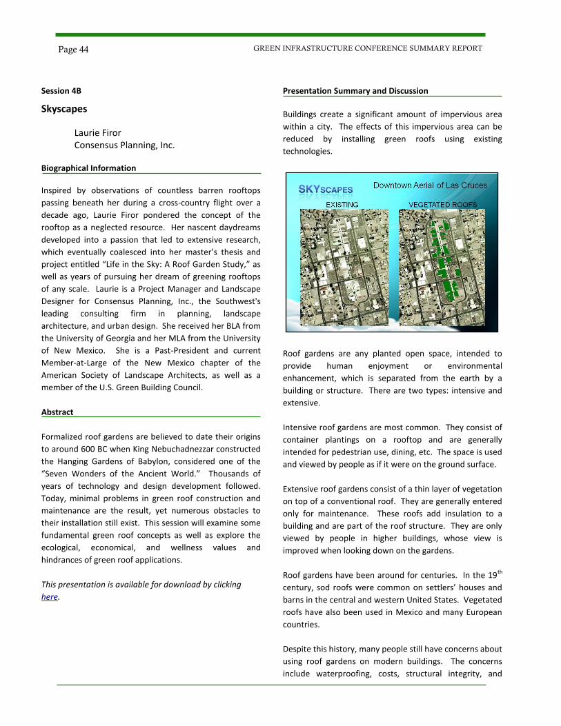
Session 4B
Skyscapes
Laurie Firor Consensus Planning, Inc.
Biographical Information Inspired by observations of countless barren rooftops
passing beneath her during a cross-country flight over a
decade ago, Laurie Firor pondered the concept of the
rooftop as a neglected resource. Her nascent daydreams
developed into a passion that led to extensive research,
which eventually coalesced into her master’s thesis and
project entitled “Life in the Sky: A Roof Garden Study,” as
well as years of pursuing her dream of greening rooftops
of any scale. Laurie is a Project Manager and Landscape
Designer for Consensus Planning, Inc., the Southwest's
leading consulting firm in planning, landscape
architecture, and urban design. She received her BLA from
the University of Georgia and her MLA from the University
of New Mexico. She is a Past-President and current
Member-at-Large of the New Mexico chapter of the
American Society of Landscape Architects, as well as a
member of the U.S. Green Building Council.
Abstract
Formalized roof gardens are believed to date their origins
to around 600 BC when King Nebuchadnezzar constructed
the Hanging Gardens of Babylon, considered one of the
“Seven Wonders of the Ancient World.” Thousands of
years of technology and design development followed.
Today, minimal problems in green roof construction and
maintenance are the result, yet numerous obstacles to
their installation still exist. This session will examine some
fundamental green roof concepts as well as explore the
ecological, economical, and wellness values and
hindrances of green roof applications.
This presentation is available for download by clicking
here.
Presentation Summary and Discussion
Buildings create a significant amount of impervious area
within a city. The effects of this impervious area can be
reduced by installing green roofs using existing
technologies.
Roof gardens are any planted open space, intended to
provide human enjoyment or environmental
enhancement, which is separated from the earth by a
building or structure. There are two types: intensive and
extensive.
Intensive roof gardens are most common. They consist of
container plantings on a rooftop and are generally
intended for pedestrian use, dining, etc. The space is used
and viewed by people as if it were on the ground surface.
Extensive roof gardens consist of a thin layer of vegetation
on top of a conventional roof. They are generally entered
only for maintenance. These roofs add insulation to a
building and are part of the roof structure. They are only
viewed by people in higher buildings, whose view is
improved when looking down on the gardens.
Roof gardens have been around for centuries. In the 19th
century, sod roofs were common on settlers’ houses and
barns in the central and western United States. Vegetated
roofs have also been used in Mexico and many European
countries.
Despite this history, many people still have concerns about
using roof gardens on modern buildings. The concerns
include waterproofing, costs, structural integrity, and
Page 44 GREEN INFRASTRUCTURE CONFERENCE SUMMARY REPORT
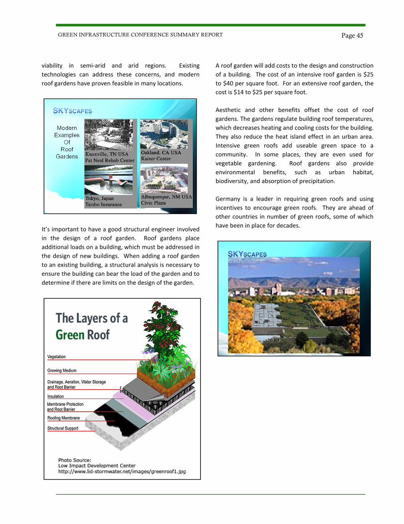
viability in semi-arid and arid regions. Existing
technologies can address these concerns, and modern
roof gardens have proven feasible in many locations.
It’s important to have a good structural engineer involved
in the design of a roof garden. Roof gardens place
additional loads on a building, which must be addressed in
the design of new buildings. When adding a roof garden
to an existing building, a structural analysis is necessary to
ensure the building can bear the load of the garden and to
determine if there are limits on the design of the garden.
A roof garden will add costs to the design and construction
of a building. The cost of an intensive roof garden is $25
to $40 per square foot. For an extensive roof garden, the
cost is $14 to $25 per square foot.
Aesthetic and other benefits offset the cost of roof
gardens. The gardens regulate building roof temperatures,
which decreases heating and cooling costs for the building.
They also reduce the heat island effect in an urban area.
Intensive green roofs add useable green space to a
community. In some places, they are even used for
vegetable gardening. Roof gardens also provide
environmental benefits, such as urban habitat,
biodiversity, and absorption of precipitation.
Germany is a leader in requiring green roofs and using
incentives to encourage green roofs. They are ahead of
other countries in number of green roofs, some of which
have been in place for decades.
Page 45 GREEN INFRASTRUCTURE CONFERENCE SUMMARY REPORT
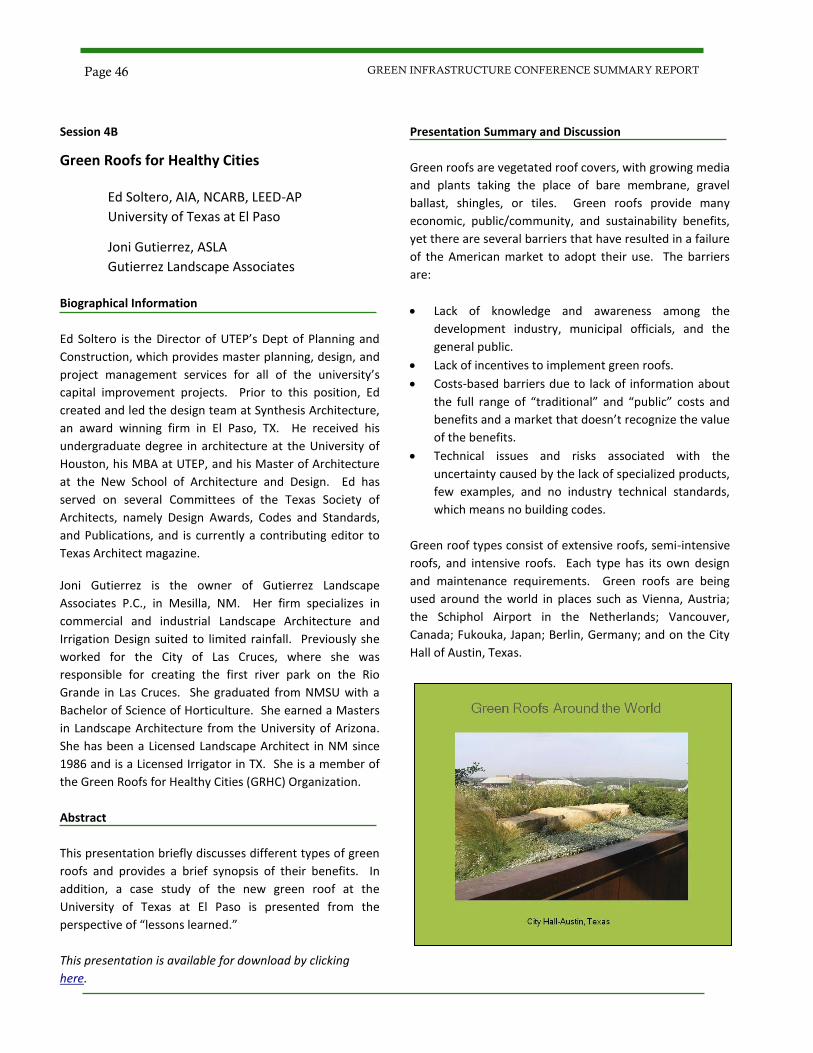
Session 4B
Green Roofs for Healthy Cities
Ed Soltero, AIA, NCARB, LEED-AP
University of Texas at El Paso
Joni Gutierrez, ASLA
Gutierrez Landscape Associates
Biographical Information
Ed Soltero is the Director of UTEP’s Dept of Planning and
Construction, which provides master planning, design, and
project management services for all of the university’s
capital improvement projects. Prior to this position, Ed
created and led the design team at Synthesis Architecture,
an award winning firm in El Paso, TX. He received his
undergraduate degree in architecture at the University of
Houston, his MBA at UTEP, and his Master of Architecture
at the New School of Architecture and Design. Ed has
served on several Committees of the Texas Society of
Architects, namely Design Awards, Codes and Standards,
and Publications, and is currently a contributing editor to
Texas Architect magazine.
Joni Gutierrez is the owner of Gutierrez Landscape
Associates P.C., in Mesilla, NM. Her firm specializes in
commercial and industrial Landscape Architecture and
Irrigation Design suited to limited rainfall. Previously she
worked for the City of Las Cruces, where she was
responsible for creating the first river park on the Rio
Grande in Las Cruces. She graduated from NMSU with a
Bachelor of Science of Horticulture. She earned a Masters
in Landscape Architecture from the University of Arizona.
She has been a Licensed Landscape Architect in NM since
1986 and is a Licensed Irrigator in TX. She is a member of
the Green Roofs for Healthy Cities (GRHC) Organization.
Abstract
This presentation briefly discusses different types of green
roofs and provides a brief synopsis of their benefits. In
addition, a case study of the new green roof at the
University of Texas at El Paso is presented from the
perspective of “lessons learned.”
This presentation is available for download by clicking
here.
Presentation Summary and Discussion
Green roofs are vegetated roof covers, with growing media
and plants taking the place of bare membrane, gravel
ballast, shingles, or tiles. Green roofs provide many
economic, public/community, and sustainability benefits,
yet there are several barriers that have resulted in a failure
of the American market to adopt their use. The barriers
are:
Lack of knowledge and awareness among the
development industry, municipal officials, and the
general public.
Lack of incentives to implement green roofs.
Costs-based barriers due to lack of information about
the full range of “traditional” and “public” costs and
benefits and a market that doesn’t recognize the value
of the benefits.
Technical issues and risks associated with the
uncertainty caused by the lack of specialized products,
few examples, and no industry technical standards,
which means no building codes.
Green roof types consist of extensive roofs, semi-intensive
roofs, and intensive roofs. Each type has its own design
and maintenance requirements. Green roofs are being
used around the world in places such as Vienna, Austria;
the Schiphol Airport in the Netherlands; Vancouver,
Canada; Fukouka, Japan; Berlin, Germany; and on the City
Hall of Austin, Texas.
Page 46 GREEN INFRASTRUCTURE CONFERENCE SUMMARY REPORT
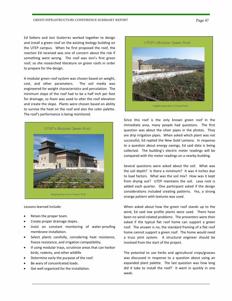
Ed Soltero and Joni Gutierrez worked together to design
and install a green roof on the existing biology building on
the UTEP campus. When he first proposed the roof, the
reaction Ed received was one of concern about the risk if
something went wrong. The roof was Joni’s first green
roof, so she researched literature on green roofs in order
to prepare for the design.
A modular green roof system was chosen based on weight,
cost, and other parameters. The soil media was
engineered for weight characteristics and percolation. The
minimum slope of the roof had to be a half inch per foot
for drainage, so foam was used to alter the roof elevation
and create the slope. Plants were chosen based on ability
to survive the heat on the roof and also the color palette.
The roof’s performance is being monitored.
Lessons learned include:
Retain the proper team.
Create proper drainage slopes.
Insist on constant monitoring of water-proofing
membrane installation.
Select plants carefully, considering heat resistance,
freeze resistance, and irrigation compatibility.
If using modular trays, scrutinize areas that can harbor
birds, rodents, and other wildlife.
Determine early the purpose of the roof.
Be wary of concentrated loads.
Get well organized for the installation.
Since this roof is the only known green roof in the
immediate area, many people had questions. The first
question was about the silver pipes in the photos. They
are drip irrigation pipes. When asked which plant was not
successful, Ed replied the New Gold Lantana. In response
to a question about energy savings, Ed said data is being
collected. The building’s electric meter readings will be
compared with the meter readings on a nearby building.
Several questions were asked about the soil. What was
the soil depth? Is there a minimum? It was 4 inches due
to load factors. What was the soil mix? How was it kept
from drying out? UTEP maintains the soil. Lava rock is
added each quarter. One participant asked if the design
considerations included creating patterns. Yes, a strong
orange pattern with textures was used.
When asked about how the green roof stands up to the
wind, Ed said low profile plants were used. There have
been no wind-related problems. The presenters were then
asked if the typical flat roof home can support a green
roof. The answer is no, the standard framing of a flat roof
home cannot support a green roof. The home would need
a truss joint system. A structural engineer should be
involved from the start of the project.
The potential to use herbs and agricultural crops/grasses
was discussed in response to a question about using an
expanded plant palette. The last question was how long
did it take to install the roof? It went in quickly in one
week.
Page 47 GREEN INFRASTRUCTURE CONFERENCE SUMMARY REPORT

Session 4C
Stormwater Harvesting: Converting Nuisance Runoff into a Beneficial Resource While Saving Money
Van Clothier Stream Dynamics, Inc.
Biographical Information
Van Clothier graduated from the University of California at
San Diego in 1982 with a degree in physics. His firm,
Stream Dynamics, Inc., specializes in turning runoff and
erosion problems into water harvesting opportunities with
water harvesting earth works, urban stormwater retrofits,
and riparian restoration. Van has worked extensively in
New Mexico and Arizona on a variety of restoration
projects with regional drylands, stream restoration, and
water harvesting experts, including Bill Zeedyk and Brad
Lancaster. He has completed the River Restoration and
Natural Channel Design stream restoration course
schedule taught by Dr. Dave Rosgen. Van is the co-author
with Bill Zeedyk of a book called Let the Water Do the
Work: Induced Meandering, an Evolving Method for
Restoring Incised Channels, published November 2009.
Recent projects include designing water harvesting
stormwater retrofits for the City of Santa Fe and restoring
a very large ciénega (desert marsh) near the Mexican
border.
Abstract
Understanding the dynamics of stormwater management
is often obscured by fancy software modeling and over-
engineered design. There is a disconnect between what
people see when they look at a grassy swale and the
stormwater management plans that quickly drain away
any water as if it were not… water - our most valuable
resource! Learn a holistic and intuitive approach which
brings more cost effective, efficient, and beautiful results.
This presentation demonstrates the basic principles for
putting urban stormwater runoff to beneficial use for
healthy communities in a way that is both economically
and ecologically sustainable.
This presentation is available for download by clicking
here.
Presentation Summary and Discussion
Van Clothier opened his presentation by describing how
he has studied the processes shaping the arroyos flowing
through his property in Silver City, NM. The deep gullies
he observed looked wrong to him, like a scar on the
landscape in need of healing. This realization caused Van
to look for the causes of the problems, and then to seek
methods for restoring the waterways, which he now does
through his company, Stream Dynamics.
One significant cause of arroyo degradation is the increase
in runoff that occurs when impervious surfaces are
constructed. Water harvesting is a means to mitigate this
increase. It converts nuisance runoff into a valuable
resource. Brad Lancaster, an expert in drylands stream
restoration and water harvesting, published a two volume,
rainwater harvesting manual for drylands. He has eight
water harvesting principles for drylands:
1. Begin with long and thoughtful observation.
2. Start at the highpoint of the watershed and work your
way down.
3. Start small and simple.
4. Spread and infiltrate the flow of water.
5. Always plan an overflow route, and manage that
overflow as a resource.
6. Maximize living and organic ground cover.
7. Maximize beneficial relationships and efficiency by
“stacking functions.”
8. Continually reassess the system: “the feedback loop.”
Page 48 GREEN INFRASTRUCTURE CONFERENCE SUMMARY REPORT
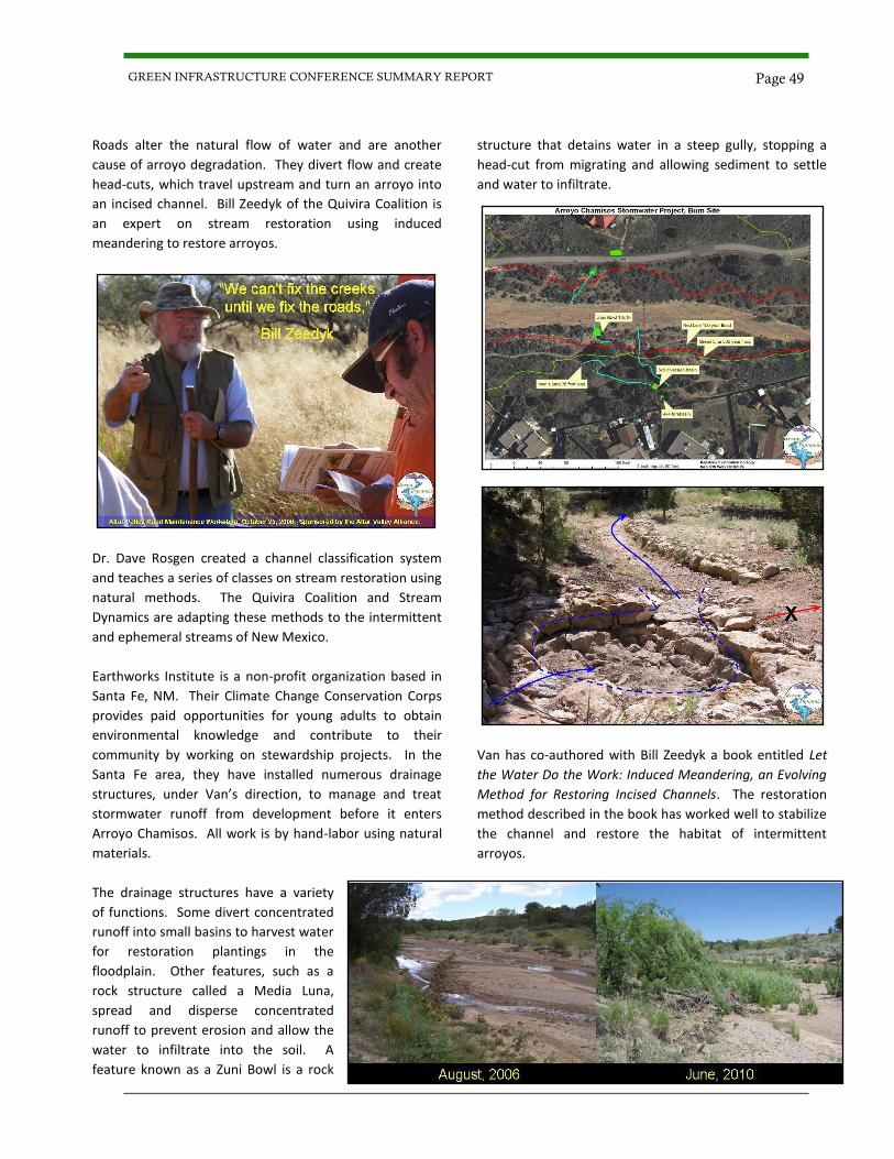
Roads alter the natural flow of water and are another
cause of arroyo degradation. They divert flow and create
head-cuts, which travel upstream and turn an arroyo into
an incised channel. Bill Zeedyk of the Quivira Coalition is
an expert on stream restoration using induced
meandering to restore arroyos.
Dr. Dave Rosgen created a channel classification system
and teaches a series of classes on stream restoration using
natural methods. The Quivira Coalition and Stream
Dynamics are adapting these methods to the intermittent
and ephemeral streams of New Mexico.
Earthworks Institute is a non-profit organization based in
Santa Fe, NM. Their Climate Change Conservation Corps
provides paid opportunities for young adults to obtain
environmental knowledge and contribute to their
community by working on stewardship projects. In the
Santa Fe area, they have installed numerous drainage
structures, under Van’s direction, to manage and treat
stormwater runoff from development before it enters
Arroyo Chamisos. All work is by hand-labor using natural
materials.
The drainage structures have a variety
of functions. Some divert concentrated
runoff into small basins to harvest water
for restoration plantings in the
floodplain. Other features, such as a
rock structure called a Media Luna,
spread and disperse concentrated
runoff to prevent erosion and allow the
water to infiltrate into the soil. A
feature known as a Zuni Bowl is a rock
structure that detains water in a steep gully, stopping a
head-cut from migrating and allowing sediment to settle
and water to infiltrate.
Van has co-authored with Bill Zeedyk a book entitled Let
the Water Do the Work: Induced Meandering, an Evolving
Method for Restoring Incised Channels. The restoration
method described in the book has worked well to stabilize
the channel and restore the habitat of intermittent
arroyos.
Page 49 GREEN INFRASTRUCTURE CONFERENCE SUMMARY REPORT
Dear Colleagues,
Thank you for your interest in “Green Infrastructure in the Southwest: Challenges and Opportuni-
ties.” We hope this summary report helps to raise awareness about the application of green principles
to infrastructure and development projects.
We would like to thank Peter Bennett for providing the conference logo. In addition, we would like to
thank Nancy Montoya with the City of Las Cruces Public Works Department and members of the
Doña Ana County Master Gardeners for their valuable assistance in preparing for the conference. We
would also like to acknowledge the efforts of Claude Morelli, Joni Newcomer and Melissa Gorham in
securing continuing education credits for AICP and AIA.
We wish you all the best in your endeavors.
GIC Organizing Committee:
Jenny Abbott - Martich Professional Services, PLLC
Dan Andersen - CH2M HILL
Jeff Anderson - NMSU Extension Service
Robert Armijo - Doña Ana County Engineering Services
Peter Bennett - City of Las Cruces
Christine Chavez - City of Las Cruces
Melissa Gorham - Contech Construction Products, Inc
Susan Lowell - City of Las Cruces
Ross Lujan - CH2M HILL
Jeff Mann - Parametrix
Katrina Martich - Martich Professional Services, PLLC
Carol McCall - City of Las Cruces
Suzanna Perea - EPA Region 6
Jaime Rodriguez - City of Las Cruces
Tom Schuster - City of Las Cruces
Gill Sorg - Las Cruces City Councilor District 5
Page 50 GREEN INFRASTRUCTURE CONFERENCE SUMMARY REPORT
Thanks to our Generous Sponsors!
Page 51 GREEN INFRASTRUCTURE CONFERENCE SUMMARY REPORT

Minimum 10% Post
Consumer Content
GREEN INFRASTRUCTURE CONFERENCE SUMMARY REPORT