Embed Size (px)
Citation preview
Gravimetric and electrical-IP methods applied to water resources and risk management in karstic areas: a case study in Paraná State, Brazil
[1]Francisco José Fonseca FERREIRA, [2]Jair Silveira da SILVA JUNIOR
[1]Laboratório de Pesquisas em Geofísica Aplicada/LPGA-UFPR, Centro Poltécnico, Jardim das Américas, Caixa Postal 19045, CEP 81531-980, Curitiba-PR, Brasil, e-mail: [email protected]
[2]In memoriam ABSTRACT This paper presents a geophysical study of a karstic region that supplies a great part of the drinking water consumed in Curitiba, the capital city of Paraná in southern Brazil. The region studied presents, in almost 80 percent of its extension, elements of a complete karstic aquifer system, such as caves, underground water flow, dolines and sinkholes. From a geotechnical point of view, however, karstic systems correspond to unstable areas whose proper occupation and exploitation require previous geophysical and structural knowledge. In fact, many cases of subsidence and collapse have occurred in that region due to irregular occupation and inappropriate groundwater exploitation. Geophysical methods were applied around the Ambrosio Bini School. This structure collapsed, most probably because it was constructed over a risk area where there are two water exploitation wells. Microgravimetrical, resistivity, and induced polarization (IP) methods were applied to an approximately 11,200 m2 collapsed area that surrounds Ambrosio Bini Scholl, in order to investigate qualitatively and quantitatively the hydrogeological and geotechnical conditions of geological structures revealed by geophysical maps. Collapse probably occurred because the school was built in a risk area where two groundwater wells are present. Four hundred and seventeen gravimetric stations in a square 5m x 5m spacing grid were located. Ten vertical electric soundings (VES) spaced by 5 meters were performed in a Schlumberger array. A total of 550 meters of electrical-IP profiling was performed in five lines separated from each other by 10 meters following the dipole-dipole array (AB=MN=10m). The gravity data, automatically corrected for earth tides and instrumental drift, were collected using a Scintrex CG-3 digital gravity meter, with 60-second readings at each point. The electrical-IP profiling data were collected with a high power transmitter (VIP 3000W) and a multichannel spectral receiver (ELREC 10), manufactured by Iris Instruments. As caves and voids present a high density-resistivity-chargeability contrast with their surrounding rocks, gravimetric and electrical-IP methods were then applied in order to identify and quantify near-surface occurrences of such structures, whether filled or not with sediments and/or water, which might compromise ground stability and cause future geotechnical problems. The resulting gravity and resistivity-chargeability maps clearly show areas of considerable mass deficiency and electrical-IP anomalies, respectively. Gravimetry and resistivity-chargeability inversion revealed how large and deep the features were presented in geophysical anomaly maps. Gravity inversion (Fig.1) was performed by using an open-code 3D algorithm developed by USGS (United States Geological Survey) and implemented Fortran programming language. The electrical-IP profiling inversion was developed by Zonge 2-D Inversion for InteractiveTM IP software (Interpex). In the VES (1D), electrical-IP profiling (2D) and gravity (3D) inversion process, the geometric forms of the bodies are modeled using the observed geophysical data and then, the effect caused by this model is calculated. The geophysical effects, the observed and the calculated, are compared and if they agree, the inversion was successfully done. The models allows the visualization of the mass and resistivity-chargeability distribution in the subsurface, characterizing underground structures that may constitute the fragility of the aquifer system and identifying areas that present some geotechnical risk. The results of studies like this can orientate appropriate future hydrogeological drilling and predict potential risk areas.
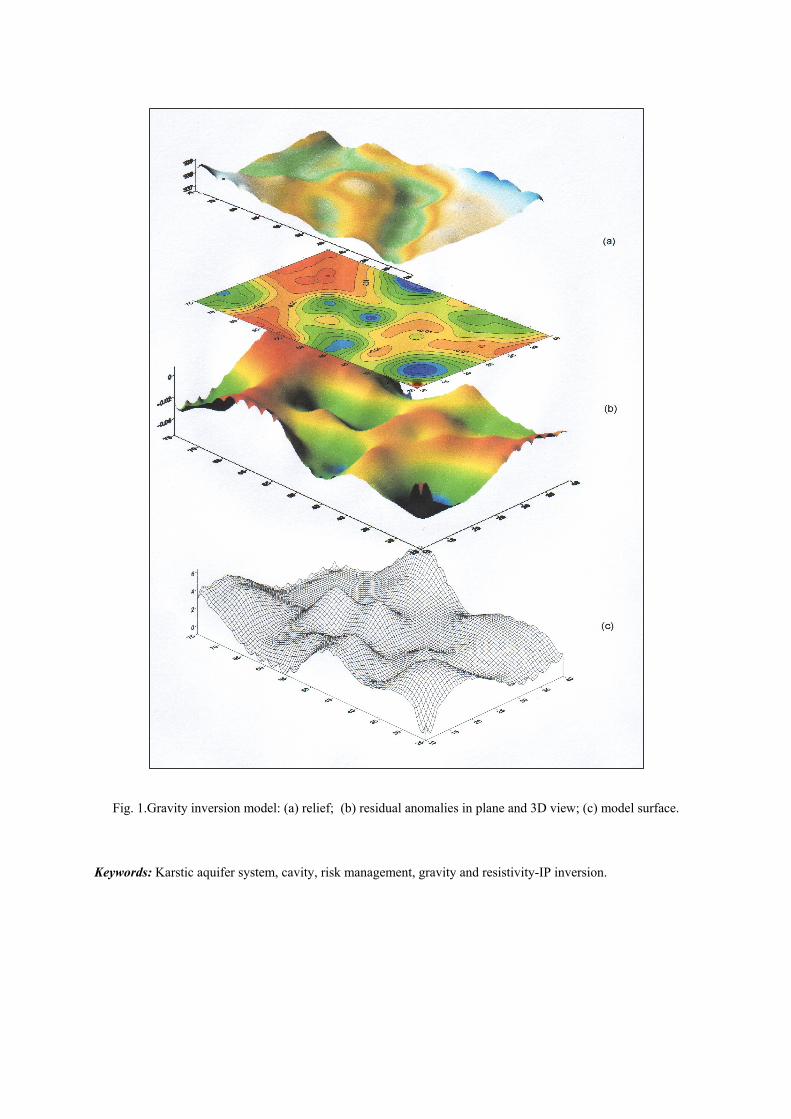
Fig. 1.Gravity inversion model: (a) relief; (b) residual anomalies in plane and 3D view; (c) model surface.
Keywords: Karstic aquifer system, cavity, risk management, gravity and resistivity-IP inversion.