Embed Size (px)
Citation preview

Grantham Southern Quadrant Link Road
Supplementary Environmental Statement
October 2015 Produced for Prepared by 209-215 Blackfriars Road London SE1 8NL T: 0207 803 2600

Grantham Southern Quadrant Link Road
Supplementary Environmental Statement-October2015
© Mouchel 2015 i
Document Control Sheet
Project Title Grantham Southern Quadrant Link Road
Report Title Supplementary Environmental Statement
Revision 4.0
Status Final V2
Control Date October 2015
Record of Issue
Issue Status Author Date Check Date Authorised Date
1.0 Final H Roberts July 15 N Kretschmer July 15 P Reid July 15
2.0 Draft H Roberts Sep 15 N Kretschmer Sep 15 P Reid Sep 15
3.0 Final H Roberts Sep 15 N Kretschmer Sep 15 N Venema Sep 15
4.0 Final V2 H Roberts
S Hales
Oct 15 N Kretschmer Oct 15 N Venema Oct 15
Distribution
Organisation Contact Copies
South Kesteven District Council Sylvia Bland
3 Hard
copies
5 CDs

Grantham Southern Quadrant Link Road
Supplementary Environmental Statement-October2015
© Mouchel 2015 ii
This Report is presented to Lincolnshire County Council in respect of the Grantham Southern Quadrant Link Road and may not be used or relied on by any other person or by the client in relation to any other matters not covered specifically by the scope of this Report.
Notwithstanding anything to the contrary contained in the Report, Mouchel Limited is obliged to exercise reasonable skill, care and diligence in the performance of the services required by Lincolnshire County Council and Mouchel Limited shall not be liable except to the extent that it has failed to exercise reasonable skill, care and diligence, and this report shall be read and construed accordingly.
This Report has been prepared by Mouchel Limited. No individual is personally liable in connection with the preparation of this Report. By receiving this Report and acting on it, the client or any other person accepts that no individual is personally liable whether in contract, tort, for breach of statutory duty or otherwise.

Grantham Southern Quadrant Link Road
Supplementary Environmental Statement-October2015
© Mouchel 2015 iii
Contents
Document Control Sheet............................................................................................... i
Contents ....................................................................................................................... iii
Tables ............................................................................................................................ v
1 Introduction ......................................................................................................... 6
1.1 Background ........................................................................................................... 6
1.2 Context of the Assessment ................................................................................... 7
1.3 The proposed changes .......................................................................................... 7
2 Updated Impact Assessment ........................................................................... 10
2.1 Effects associated with the consented scheme ................................................... 10
2.2 Effects associated with the currently proposed scheme incorporating the proposed
changes to the consented scheme ............................................................................... 11
2.3 Alternatives .......................................................................................................... 11
3 Cumulative Impacts .......................................................................................... 23
3.1 Introduction .......................................................................................................... 23
3.2 The Consented Scheme ...................................................................................... 23
3.3 The currently proposed scheme .......................................................................... 23
4 Conclusions and Mitigation ............................................................................. 28
4.1 Mitigation ............................................................................................................. 28
4.2 Conclusions ......................................................................................................... 28
Figures ......................................................................................................................... 29
Annex 1 - Heritage Assessment ................................................................................ 30
1 Heritage Assessment (2015) ............................................................................ 31
1.1 Introduction .......................................................................................................... 31
1.2 The relevant historic environment record should have been consulted and the
heritage assets assessed using appropriate expertise ................................................. 31

Grantham Southern Quadrant Link Road
Supplementary Environmental Statement-October2015
© Mouchel 2015 iv
1.3 Local planning authorities should require developers to submit an appropriate
desk-based assessment ............................................................................................... 32
1.4 Describe the significance of any heritage assets affected, including any
contribution made by their setting ................................................................................. 32
1.5 Where necessary, a field evaluation ................................................................... 32
1.6 Mitigation ............................................................................................................. 33
1.7 Updated Assessment .......................................................................................... 34
1.8 Conclusion ........................................................................................................... 34

Grantham Southern Quadrant Link Road
Supplementary Environmental Statement-October2015
© Mouchel 2015 v
Tables
Table 2-1 – Significant effects of the GSQLR as identified in 2013 10
Table 2-2 – Assessment of the currently proposed scheme 12
Table 3 – Areas of Archaeological Mitigation 33
Table 4 – Table of impacts on Cultural Heritage Assets 35

Grantham Southern Quadrant Link Road
Supplementary Environmental Statement-October2015
© Mouchel 2015 6
1 Introduction
1.1 Background
1.1.1 In November 2013, South Kesteven Borough Council (SKBC) granted planning permission (Consent S13/0775/EIAFP) for a proposed Grantham Southern Quadrant Link Road (GSQLR).
1.1.2 The planning permission that was granted was for the “Construction of Southern Quadrant Link Road (SQLR) comprising a new 3km single carriageway road between B1174 Spittlegate Level and A52 Somerby Hill including a new bridge spanning the East Coast Main Line and River Witham. Works to include a new 5 arm roundabout at B1174 Spittlegate Level, improvements to the existing A52/B6403 roundabout, associated new junctions/access roads, new cycleway/footpath at Whalebone Lane, site compound/construction and storage areas, re-contouring of ground levels, formation of attenuation ponds and diversion of public right of way”.
1.1.3 The permission was made subject to a number of conditions, one of which, Condition 2, places a requirement on the promoter of the scheme, Lincolnshire County Council (LCC), to undertake the development in accordance with, amongst other documents and drawings, the Environmental Statement (Mouchel, March 2013) and Supplementary Environmental Statement (Mouchel, September 2013).
1.1.4 LCC is proposing a number of changes to the design of the consented scheme and is seeking approval to the changes under Section 73 (S73) of the Town and Country Planning Act 1990. An application can be made under S73 to vary or remove conditions associated with a planning permission. One of the uses of a Section 73 application is to seek a minor material amendment, where there is a relevant condition that can be varied1.
1.1.5 The proposed scheme incorporating the changes is shown in Figures 1059526-ENV-001a and 1059526-ENV-001b. They comprise:
Inclusion of an additional span at the eastern end of the proposed viaduct and changes to the extent of the approach embankments to the viaduct as a result of the inclusion of the additional span;
Re-alignment of a proposed access track to a proposed attenuation pond located east of the river and railway and north of the proposed viaduct;
Provision of an access track beneath the westernmost span of the viaduct to enable a wayleave for the electricity distribution company; and
Changes to the landscape mitigation.
1 Planning Practice Guidance.

Grantham Southern Quadrant Link Road
Supplementary Environmental Statement-October2015
© Mouchel 2015 7
1.1.6 For the avoidance of doubt, we refer to the development that was granted planning permission in 2013 as the ‘consented scheme’. The scheme being amended through the S73 process is referred to as the ‘currently proposed scheme’. It is noteworthy that the currently proposed scheme incorporates the elements of the consented scheme that are not being amended and, therefore, an assessment of the currently proposed scheme can be said to incorporate it in entirety and not just the amendments listed above in 1.1.5.
1.2 Context of the Assessment
1.2.1 The Environmental Statement for the consented scheme was prepared and submitted as part of the original planning application, it having been concluded the project comprised Schedule 2 development as defined in the Town and Country Planning (Environmental Impact Assessment) Regulations 2011 (the Regulations).
1.2.2 The Regulations state in paragraph 13 of Column 1 of Schedule 2 that the following is EIA development: “any change to or extension of development of a description listed in paragraphs 1 to 12 of column 1 of this table, where that development is already authorised, executed or in the process of being executed”. The currently proposed scheme is such a development.
1.2.3 The currently proposed scheme, comprising the consented scheme incorporating the proposed changes, has therefore been reviewed to establish if its construction and use would be likely to result in environmental effects which have not already been identified and considered in GSQLR-ES-March2013 and GSQLR-SES-September 2013. This review is presented in this Supplementary Environmental Statement (GSQLR-SES-September2015) which forms part of the relevant environmental information for the determination of the currently proposed scheme.
1.2.4 The review has established there would be no additional impacts to those identified in the GSQLR-ES-March2013 and GSQLR-SES-September2013 or material change in the order of identified impacts and their consequent effects.
1.2.5 The following sections of this GSQLR-SES-September2015 describe the proposed changes which form the focus of the S73 application and outline the findings of the review of likely environmental impacts which it is anticipated would result from the implementation and future use of the currently proposed scheme.
1.3 The proposed changes
1.3.1 The modified layout for the currently proposed scheme is shown in Figure 1059526-ENV-001b. Those parts of the consented scheme which would be modified as a result of the adoption of the proposed changes are indicated in blue in the figure.
1.3.2 The changes would be accommodated within the currently proposed land take for the consented scheme and would not involve a marked change in the scale or combined extent of the viaduct and its embankments.
1.3.3 The changes would not require the working areas, the timescales or the approach to the construction of the viaduct, the embankments and the associated works to be modified.

Grantham Southern Quadrant Link Road
Supplementary Environmental Statement-October2015
© Mouchel 2015 8
Changes to the proposed viaduct and approach embankments.
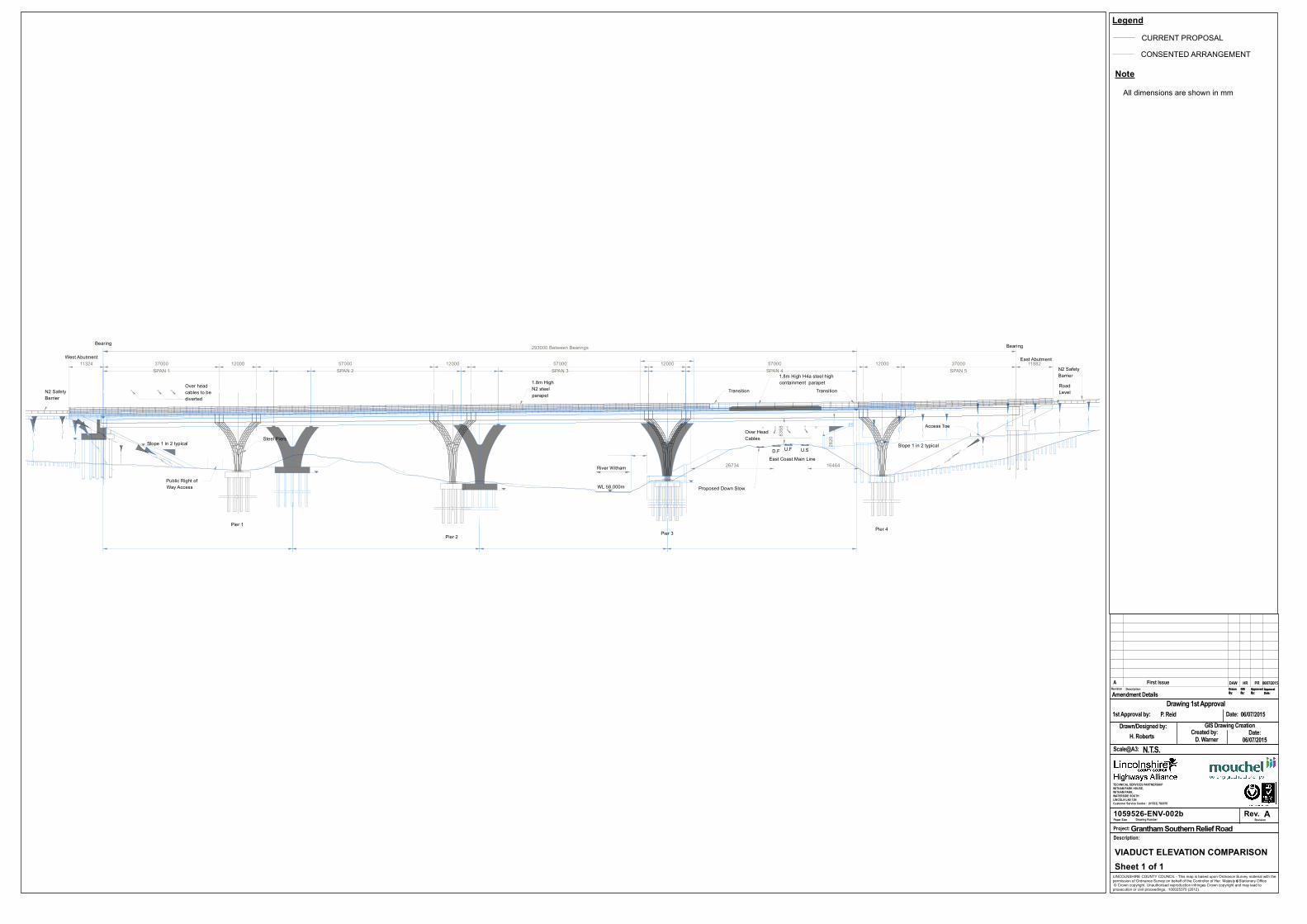
1.3.4 The consented four-span structure would be replaced with a five-span structure as shown in Figure 1059526-ENV-002a. This would involve modification to the number and location of piers and their foundations and to the approach embankments housing the east and west abutments at each end of the structure. Comparison of the number, location and form of the proposed piers and modified profiles for the approach embankments with those forming part of the consented scheme, is provided in Figure 1059526-ENV-002b.
1.3.5 The five-span viaduct would be 293m long compared to the 250m-long consented structure. The amended structure, including the proposed parapets, would be approximately 1m more elevated in the valley landscape. The eastern approach to the structure would also be some 3.5m wider than the consented proposal by virtue of the widening of the verge on the southern side of the main carriageway to allow for visibility around the left hand bend. The structure itself would be some 1.8m wider than the consented proposal by virtue of the widening of the verge each side of the main carriageway.
1.3.6 The newly proposed piers would be constructed from steel rather than concrete, as originally consented. Pier foundations would be set within a concrete plinth, as originally consented. The surface area occupied by each plinth would be 201m2 compared to 113m2 for the plinths included in the consented scheme. The steel piers would be smaller in width than the consented concrete piers.
1.3.7 Pier 1 would be located approximately 37m from the viaduct bearing on the western embankment. As shown in Figure 1059526-ENV-002b, the plinth would be located at existing ground level removing the need to grade the existing land profile, as required under the consented arrangement.
1.3.8 The centre of Pier 2 would be located approximately 17.5m to the west of the centre point of the consented position.
1.3.9 Pier 3 would be positioned in the same location as the consented arrangement, although due to the smaller plinth, the structure would be 2.4m further from the River Witham than the consented arrangement.
1.3.10 Pier 4 is an additional pier to the consented arrangement. The plinth would be positioned at existing ground level at the same chainage as the bearings of the consented arrangement and approximately 37m from the viaduct bearing on the eastern embankment.
1.3.11 The inclusion of the additional span would involve modification to the consented extent and scale of the approach embankments at the western and eastern ends of the viaduct. The differences in extent and profile are shown in Figures 105952-ENV-001b and 105952-ENV-002b. The figures demonstrate there would be small-scale modification to the extent and profile of the western approach embankment such that there would be no marked change in the scale and form of the engineered earthworks. They also demonstrate there would not be a marked change in the scale and form of

Grantham Southern Quadrant Link Road
Supplementary Environmental Statement-October2015
© Mouchel 2015 9
the eastern approach embankment although the change in length, extent and profile would be greater than for the western embankment.
Changes to the layout of the access to the attenuation pond east of the River Witham
1.3.12 The consented scheme allowed for an underpass through the eastern approach embankment to provide for maintenance access to the proposed attenuation pond north of the proposed road and east of the River Witham as indicated in Figure 105952-ENV-001a. The inclusion of an additional span allows sufficient space for this access track to be aligned beneath the additional span, avoiding the need for the construction of an underpass through the approach embankment. The amendments accordingly provide for omission of the underpass and re-alignment of the access track as indicated in Figure 105952-ENV-001b.
Provision of an access track to enable a wayleave for the electricity distribution company
1.3.13 It is proposed that a new access track to the western attenuation pond to the River Witham is provided to act as a wayleave for Western Power Distribution. Figure 105952-ENV-001a shows that the access to the attenuation pond continues northwards around its eastern edge, terminating at the boundary of the development.
1.3.14 This track will be formed of a 4m wide roadway with 1m verges and will also form part of the originally proposed diversion of footpath number L/Pon/3/1 as indicated in Figure 105952-ENV-001b.
Proposed changes to the landscape mitigation
1.3.15 Figures 1045388-ENV-VIS-005-E and 1045388-ENV-VIS-006-E show the proposed changes to the landscape mitigation for the currently proposed scheme in light of the changes to the viaduct, embankment and tracks.

Grantham Southern Quadrant Link Road
Supplementary Environmental Statement-October2015
© Mouchel 2015 10
2 Updated Impact Assessment
2.1 Effects associated with the consented scheme
2.1.1 The effects, including those identified as significant, associated with the consented scheme and as presented in the GSQLR-ES-March2013 and GSQLR-SES-September2013 are shown in Table 2-1.
Table 2-1 – Significant effects of the GSQLR as identified in 2013
Environmental Aspects
Environmental Effects
Air Quality No significant effects were identified
Cultural Heritage Moderate to slight significant effects were identified for buried archaeological remains.
Slight significant effects upon built heritage assets were identified.
Moderate significant effects upon historic landscapes were identified.
Ecology and Nature Conservation
Positive significant impacts for Calcareous Grassland, Hedgerows, Trees and Woodland and Schedule 9 plants were identified. There are no residual negative significant impacts.
Geology and Soils No significant effects were identified.
Landscape and Visual Amenity
Significant impacts upon landscape character area LCA: A.
Significant effects upon visual receptors and public rights of way were identified.
Noise and Vibration
Four dwellings were identified as being subject to major adverse impacts.
Road Drainage and the Water Environment
Slight significant effects were identified upon the River Witham and the Lincolnshire Limestone aquifer.
Land Use and Community Effects
Moderate impacts were identified upon one farm holding, a slight adverse impact upon two farm holdings and a slight adverse impact upon a commercial property.
Cumulative Impacts
The cumulative impacts chapter considered impacts in relation to the consented scheme in combination with the Spittalgate and Southern Quadrant developments.
1) Significant impact upon the local Historic Landscape.

Grantham Southern Quadrant Link Road
Supplementary Environmental Statement-October2015
© Mouchel 2015 11
Environmental Aspects
Environmental Effects
2) Significant changes for visual receptors. 3) Significant cumulative loss of agricultural land.
2.2 Effects associated with the currently proposed scheme incorporating the proposed changes to the consented scheme
2.2.1 Table 2-2 schedules the findings of the review of anticipated impacts and effects for the currently proposed scheme taking into account the proposed design changes.
2.2.2 In undertaking this review we have considered the currently proposed scheme using the data available within GSQLR-ES-March2013 and GSQLR-SES-September2013. Each individual assessment in the existing ES for the consented scheme has been revisited to consider whether the currently proposed scheme is likely to have additional or different environmental effects compared to those of the consented scheme.
2.2.3 Methodologies for the assessment of the impacts are as per those presented within the GSQLR-ES-March2013 and the GSQLR-SES-September2013. In each environmental discipline considered below in Table 2-2, we have considered whether the methodology is still suitable and whether any different conclusions can be reached for the currently proposed scheme. However, as the methodologies presented in GSQLR-ES-March2013 and GSQLR-SES-September2013 are all considered to be adequate and do not need to be amended for the currently proposed scheme, they have not been repeated below.
2.2.4 For each environmental assessment, we have also considered the baseline data that is available (the “baseline data”) and presented within the relevant environmental information for the consented scheme. It has been concluded in each instance that the baseline data is adequate for the determination of the environmental effects and have identified within Table 2-2 why this is the case.
2.3 Alternatives
2.3.1 The EIA regulations require the “main alternatives studied by the applicant” to be presented within an Environmental Statement. No additional alternatives to those presented in the GSQLR-ES-March2013 have been considered in the development of the currently proposed scheme and, hence, the information contained within the GSQLR-ES-March2013 is still relevant.
Grantham Southern Quadrant Link Road
Supplementary Environmental Statement-October2015
© Mouchel 2015 12
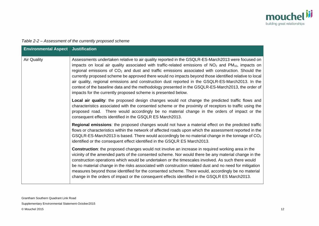
Table 2-2 – Assessment of the currently proposed scheme
Environmental Aspect Justification
Air Quality Assessments undertaken relative to air quality reported in the GSQLR-ES-March2013 were focused on impacts on local air quality associated with traffic-related emissions of NO2 and PM10, impacts on regional emissions of CO2 and dust and traffic emissions associated with construction. Should the currently proposed scheme be approved there would no impacts beyond those identified relative to local air quality, regional emissions and construction dust reported in the GSQLR-ES-March2013. In the context of the baseline data and the methodology presented in the GSQLR-ES-March2013, the order of impacts for the currently proposed scheme is presented below.
Local air quality: the proposed design changes would not change the predicted traffic flows and characteristics associated with the consented scheme or the proximity of receptors to traffic using the proposed road. There would accordingly be no material change in the orders of impact or the consequent effects identified in the GSQLR ES March2013.
Regional emissions: the proposed changes would not have a material effect on the predicted traffic flows or characteristics within the network of affected roads upon which the assessment reported in the GSQLR-ES-March2013 is based. There would accordingly be no material change in the tonnage of CO2 identified or the consequent effect identified in the GSQLR ES March2013.
Construction: the proposed changes would not involve an increase in required working area in the vicinity of the amended parts of the consented scheme. Nor would there be any material change in the construction operations which would be undertaken or the timescales involved. As such there would be no material change in the risks associated with construction related dust and no need for mitigation measures beyond those identified for the consented scheme. There would, accordingly be no material change in the orders of impact or the consequent effects identified in the GSQLR ES March2013.

Grantham Southern Quadrant Link Road
Supplementary Environmental Statement-October2015
© Mouchel 2015 13
Environmental Aspect Justification
Given that the proposed changes do not amend any aspect of the consented scheme that can have a significant effect upon the assessment as presented in the GSQLR-ES-March-2013, it has been concluded that the baseline data is relevant and suitable to inform the assessment.
It has accordingly been concluded there would be no new impacts associated with the currently proposed scheme and no material change in the order of impacts and consequent effects identified in the GSQLR-ES March 2013. Furthermore, due to these conclusions being reached, it has not been considered necessary to update the assessment through additional site surveys or baseline collation.
Cultural Heritage Studies undertaken during the preparation of the GSQLR-ES-March2013 identified 11 sites and features of cultural heritage value located in the vicinity of the proposed viaduct, approach embankments, maintenance access to the attenuation pond east of the railway and the proposed energy utility easement. These are indicated in Figure 1059526-ENV-004. Implementation of the proposed changes would not involve any extension of the working areas originally identified as being subject to disturbance during construction for the consented scheme, and would not potentially have an impact on any sites and features beyond those identified during the assessment of the currently proposed scheme reported in the GSQLR-ES-March 2013. Nor would the relationship between the completed scheme, traffic using the proposed road and the identified sites and features be changed such that there would be any material change to impacts on the setting of the sites and features.
It has accordingly been concluded there would be no new impacts associated with the proposed changes and no material change in the order of impacts and consequent effects identified in the GSQLR-ES March 2013. Furthermore, due to these conclusions being reached it has not been considered necessary to update the assessment through additional site surveys or baseline collation. Included within Annex 1 to this Supplementary Environmental Statement is a collation of the cultural heritage assessment undertaken for the consented scheme. In light of the proposals for the currently

Grantham Southern Quadrant Link Road
Supplementary Environmental Statement-October2015
© Mouchel 2015 14
Environmental Aspect Justification
proposed scheme, this Heritage Assessment 2015 has been prepared to provide a single point of reference for assessment and mitigation proposals, and to provide sufficient information for the planning authority to be satisfied that all information required by the National Planning Practice Framework is present.
Ecology and Nature Conservation
Designated sites, habitat types and evidence of fauna located in the vicinity of the proposed changes to the consented scheme are shown in Figures 1059526-ENV-005 and 1059526-ENV-006.
The impacts and the consequent effects predicted to arise if the changes were be implemented, are descried below.
Non-Statutorily Designated Sites
(see Figure 1059526-ENV-006)
In common with the consented scheme and incorporating the changes included in the Section 73 application, the currently proposed scheme, would involve a temporary and permanent loss of habitats contained within the Grantham BR Site of Nature Conservation Interest (SNCI). There would be no difference in the extent of the working areas required for construction of the currently proposed scheme compared to that required for construction of the consented scheme and, hence, no material difference in the extent of temporary habitat loss. There would also be no need to modify the originally proposed mitigation measures.
With regard to permanent loss, there would be a marginal difference in the small amount of the designated site that would be occupied by the completed concrete pier plinth at pier 3. An area of 200m2 would be lost compared to an area of 350m2 identified for the consented scheme.

Grantham Southern Quadrant Link Road
Supplementary Environmental Statement-October2015
© Mouchel 2015 15
Environmental Aspect Justification
Taking into account the marginal change in permanently lost habitat, it has been concluded there would be no change relative to the order of impacts and consequent effects identified in the GSQLR-SES-September2013. Furthermore, due to these conclusions being reached, it has not been considered necessary to update the assessment through additional site surveys or baseline collation.
Trees and Woodland
(see Figure 1059526-ENV-005)
The consented scheme and currently proposed scheme would both require the removal of trees and woodland where the viaduct crosses the River Witham and the East Coast Mainline Railway. Provision is made for access to the attenuation pond east of the river and north of the proposed road, and the easement is to be provided for utility access.
Compared to the consented scheme, the currently proposed scheme would not involve a material increase in clearance of trees and woodland required to accommodate construction. Nor would they require any marked modification to the planting proposed as part of the consented scheme.
It has accordingly been concluded there would be no new impacts associated with the proposed changes and no material change in the order of impacts and consequent effects identified in the GSQLR-SES September 2013. Furthermore, due to these conclusions being reached it has not been considered necessary to update the assessment through additional site surveys or baseline collation.

Grantham Southern Quadrant Link Road
Supplementary Environmental Statement-October2015
© Mouchel 2015 16
Environmental Aspect Justification
Running Water
(see Figure 1059526-ENV-005)
In common with the consented scheme, the implementation of the proposed changes would not require any direct working within the River Witham. Nor would there be a requirement for additional working areas such that the risks relative to working in the vicinity of the watercourse would be materially different.
It has accordingly been concluded there would be no new impacts associated with the proposed changes and no material change in the order of impacts and consequent effects identified in the GSQLR-SES-September-2013. Furthermore, due to these conclusions being reached it has not been considered necessary to update the assessment through additional site surveys or baseline collation.
Badger
(see Figure 1059526-ENV-005)
In common with the consented scheme the currently proposed scheme would involve the loss of an outlier sett and supporting habitat and the incorporation of mitigation measures as detailed in GSQLR-ES March2013 (Section 8.6) .
It has accordingly been concluded there would be no new impacts associated with the proposed changes and no material change in the order of impacts and consequent effects identified in the GSQLR-SES September 2013. Furthermore, due to these conclusions being reached it has not been considered necessary to update the assessment through additional site surveys or baseline collation.

Grantham Southern Quadrant Link Road
Supplementary Environmental Statement-October2015
© Mouchel 2015 17
Environmental Aspect Justification
Bats
(see Figure 1059526-ENV-005)
In common with the consented scheme the currently proposed scheme would involve the loss of 9 trees with the potential to support bats (although surveys in 2013 did not find any evidence of them being used as roosts) and the adoption of mitigation measures as detailed in the GSQLR-SES-September2013 (Table 1.7). Implementation of the proposed amendments would not involve the loss of any additional or fewer trees or structures with the potential to support bats.
It has accordingly been concluded there would be no new impacts associated with the proposed changes and no material change in the order of impacts and consequent effects identified in the GSQLR-SES-September-2013. Furthermore, due to these conclusions being reached it has not been considered necessary to update the assessment through additional site surveys or baseline collation.
White clawed crayfish Surveys reported in the GSQLR ES March2013 identified habitat suited to white-clawed crayfish within the River Witham within the application area. Subsequent surveys undertaken in October 2013 identified 13 white-clawed crayfish within the survey area. The findings of this survey were presented in the document ‘Grantham Southern Quadrant Link Road: White-Clawed Crayfish Survey’ dated 15th October 2013. Neither the consented scheme nor the currently proposed scheme would involve working within the watercourse. Both would be subject to the mitigation measures identified in the GSQLR SES March2013 (Table 1-9) ) and the mitigation measures in Section 5.3 of the October 2013 White Clawed Crayfish report namely:

Grantham Southern Quadrant Link Road
Supplementary Environmental Statement-October2015
© Mouchel 2015 18
Environmental Aspect Justification
Toolbox talks should be given to all contractors to make them aware of the presence of white-clawed crayfish and the legal implications of their presence;
Works in proximity to the River Witham should be subject to supervision by an experienced ecologist;
The areas of works should be kept to a minimum; Any works occurring close to the river banks should ideally be
programmed to take place between July and October; Where feasible, any works occurring adjacent to the river banks
should be carried out in small sections in succession; Measures should be installed to minimise siltation (such as the use of
silt blankets or meshes). These measures should be in accordance with the recommendations of the Environment Agency and Natural England;
Measures should be taken to prevent the pollution of the River Witham. These measures should be in accordance with the recommendations of the Environment Agency and Natural England;
No digging within the bed of the River Witham or to its banks should take place.
It has accordingly been concluded there would be no new impacts associated with the proposed changes and no material change in the order of impacts and consequent effects identified in the GSQLR-SES-September-2013. Furthermore, due to these conclusions being reached it has not been considered necessary to update the assessment through additional site surveys or baseline collation.

Grantham Southern Quadrant Link Road
Supplementary Environmental Statement-October2015
© Mouchel 2015 19
Environmental Aspect Justification
Geology and Soils The area within which the proposed amendments under the S73 application would occur do not contain contaminated sites which could potentially result in the release of contaminants into the environment. In common with the consented scheme, the currently proposed scheme would be subject to routine mitigation measures relating to the storage and handling of construction related materials including fuels, concrete and aggregates.
It has accordingly been concluded there would be no new impacts associated with the proposed changes and no material change in the order of impacts and consequent effects identified in the GSQLR-ES-March2013. Furthermore, due to these conclusions being reached it has not been considered necessary to update the assessment through additional site surveys or baseline collation.
Landscape and Visual Amenity (Visual Impact)
Parts of the proposed amendments included in the Section 73 application would appear in views available to 33 receptors out of a total of 53 residential, institutional, commercial and industrial receptors and 3 of 14 Public Rights of Way identified in the visual impact assessment reported in the GSQLR ES March 2013; i.e., those mentioned as having a view of the bridge or its embankments. The amendments to the viaduct and approach embankments as proposed in the currently proposed scheme would be the most prominent and discernible of the changes and would affect views for most of the 36 receptors. There would be no increase or reduction in the numbers of receptors with available views of the part of the consented scheme which would be modified by the proposed amendments.
Figure 1045388-ENV-VIS-005-E and 1045388-ENV-VIS-006-E show how modifications to the landscape mitigation is proposed along the currently proposed scheme length following the amendments proposed within this Section 73 application.
It has been concluded there would be no change in the order of visual impact specific to each of the 36 receptors should the proposed amendments be implemented. The conclusion takes into account the similarity in balance between the scale and form of the extended viaduct and approach

Grantham Southern Quadrant Link Road
Supplementary Environmental Statement-October2015
© Mouchel 2015 20
Environmental Aspect Justification
embankments included in the consented and currently proposed scheme, the small difference in the elevation of both within the valley landscape and the elevation and distance of the viewpoints experienced by the receptors. Furthermore, due to these conclusions being reached, it has not been considered necessary to update the assessment through additional site surveys or baseline collation.
Landscape and Visual Amenity (Landscape Character)
The GSQLR ES March 2013 concluded that the introduction of the viaduct and approach embankments across the valley landscape of the River Witham would have a significant effect on one of three Landscape Character Areas (LCAs) identified within the study area for the currently proposed scheme, LCA A: Grantham Scarps and Valleys. It further concluded there would be no significant effect on the other two LCAs; notably, LCA B: Kesteven Uplands and LCA C: Southern Kesteven Lincolnshire Edge.
The proposed amendments would not markedly change the originally identified order of impact and relationship of the viaduct, approach embankments and proposed planting in the context of the baseline landscape. It has accordingly been concluded there would be no change relative to the order of impacts and consequent effects identified in the GSQLR-ES-March2013.
It has accordingly been concluded there would be no new impacts associated with the proposed changes and no material change in the order of impacts and consequent effects identified in the GSQLR-ES March2013. Furthermore, due to these conclusions being reached, it has not been considered necessary to update the assessment through additional site surveys or baseline collation.
Noise and Vibration Operations: The proposed changes would not change the predicted traffic flows and characteristics for the currently proposed scheme, or the proximity of receptors to traffic using the proposed road, the factors upon which the assessment reported in the GSQLR-ES-March2013 is based. Nor would the small increase in elevation of the viaduct within the valley landscape result in any material change in

Grantham Southern Quadrant Link Road
Supplementary Environmental Statement-October2015
© Mouchel 2015 21
Environmental Aspect Justification
traffic-related noise. It has accordingly been concluded there would be no material change in the orders of impact or the consequent effects identified in the GSQLR ES March2013.
Construction: the proposed changes would not involve an increase in required working area in the vicinity of the amended parts of the consented scheme. Nor would there be any material change in the construction operations which would be undertaken or the timescales involved. As such there would be no material change in the risks associated with construction related noise and vibration and no need for mitigation measures beyond those identified for the consented scheme. There would, accordingly, be no material change in the orders of impact or the consequent effects identified in the GSQLR ES March2013.
It has accordingly been concluded there would be no new impacts associated with the proposed changes and no material change in the order of impacts and consequent effects identified in the GSQLR-ES March2013. Furthermore, due to these conclusions being reached it has not been considered necessary to update the assessment through additional site surveys or baseline collation.
Road Drainage and the Water Environment
Surface Water: The addition of a new span to the viaduct and reduction in the extent of the approach embankments would not result in a marked change in the approach to construction, or a marked increase in the surface area of carriageway and earthworks requiring drainage or the extent of specific drainage catchments included as part of the consented scheme.
Flood Risk: Positioning the pier and the change in the viaduct would not result in a significant change in the flow of the River Witham, or the runoff from the attenuation ponds.

Grantham Southern Quadrant Link Road
Supplementary Environmental Statement-October2015
© Mouchel 2015 22
Environmental Aspect Justification
Groundwater: The inclusion of a new pier and span would not result in a material change in the assessment upon groundwater because, as shown in Figure 1059526-ENV-002b, the foundations will penetrate less into the ground than the consented arrangement.
It has accordingly been concluded there would be no new impacts associated with the proposed changes and no material change in the order of impacts and consequent effects identified in the GSQLR-ES March2013. Furthermore, due to these conclusions being reached it has not been considered necessary to update the assessment through additional site surveys or baseline collation.
Land Use and Community Effects
The currently proposed scheme does not require any land outside of the planning application boundary for the consented scheme.
It has accordingly been concluded there would be no new impacts associated with the proposed changes and no material change in the order of impacts and consequent effects identified in the GSQLR-ES March2013. Furthermore, due to these conclusions being reached it has not been considered necessary to update the assessment through additional site surveys or baseline collation.
Cumulative Impacts In light of the application for the Spitalgate Heath development since the GSQLR-March2013 was published, a new and updated Cumulative Impacts assessment is provided in Section 3 below to reflect the increased knowledge. It has been concluded there would be no new impacts associated with the proposed changes and no material change in the order of impacts and consequent effects identified in the GSQLR-ES March2013.

Grantham Southern Quadrant Link Road
Supplementary Environmental Statement-October2015
© Mouchel 2015 23
3 Cumulative Impacts
3.1 Introduction
3.1.1 The EIA Regulations state in Schedule 4 that cumulative significant effects on the environment need to be included in environmental statements.
3.1.2 There are a number of different categories of cumulative impact. For the purpose of this assessment the following two definitions will be adopted:
1. Those effects which arise from incremental changes caused by a combination of actions from other existing or planned developments and the Proposed Scheme. As separate developments, the impacts may not be significant. However, when considered together, they may become significant.
2. Those effects which arise from a combination of impacts identified by different environmental disciplines, within the same Proposed Scheme.
3.2 The Consented Scheme
3.2.1 Chapter 14 of the GSQLR-ES-March2013 identified and considered the significance of the environmental effects from the cumulative impacts of the GSQLR and the Spittlegate and Southern Quadrant developments.
3.2.2 Table 2-1 above identified that there were significant impacts upon three environmental elements; historic landscape, visual receptors and agricultural land. These significant impacts had been identified as significant for the combination of the Consented Scheme, the Spittlegate Development and the Southern Quadrant development and not for a combination of two of these schemes.
3.3 The currently proposed scheme
3.3.1 Since the GSQLR application was submitted, the Spittlegate development has been renamed as the King 31 development and the Southern Quadrant development has been renamed as the Spittalgate Heath development.
3.3.2 As the King 31 development was granted planning consent in 2010, the application documents were used in the cumulative impacts assessment within the GSQLR-ES-March2013 and hence no additional information is available to consider. It is therefore concluded that all the significant impacts associated with the King 31 development will remain as they were presented within the GSQLR-ES-March2013.
3.3.3 This assessment of cumulative impacts has therefore focused on whether the currently proposed scheme introduces any additional cumulative impacts associated with the changes within the Section 73 application, or whether additional detail is available on the Spittalgate Heath development.
3.3.4 An outline planning application (with all matters reserved) at Spittalgate Heath for a mixed use urban extension was submitted in September 2014 to South Kesteven District Council (SKDC). This application was accompanied by an Environmental Statement which included an assessment of cumulative effects.

Grantham Southern Quadrant Link Road
Supplementary Environmental Statement-October2015
© Mouchel 2015 24
3.3.5 In undertaking this cumulative impact assessment the application documents for Spittalgate Heath have been reviewed to identify any further information that is available to inform this assessment.
3.3.6 It is noteworthy at this point that the cumulative assessment within the GSQLR-ES-March2013 was based upon the main components of the scheme as they were known at that time. These components are identified in Section 14.2.4 of the GSQLR-ES-March2013 and were informed by the information available within the Southern Quadrant Masterplan Supplementary Planning Document (SPD) that was adopted by SKDC in February 2013.
3.3.7 We have therefore now undertaken a review of the SPD and compared it to the information contained within the planning application for the Spittalgate Heath development. The application was submitted on the 1st of September 2014 and is for the following development:
“Application for outline planning permission to develop the site as a mixed use urban extension comprising: up to 3700 dwellings including sheltered housing for the elderly and extra care accommodation in Class C2. Up to 110,000 sq m of employment space within use classes B1, B2 and B8. B1 30%, B2 35%, B8 35%. Educational facilities including a primary school and a secondary school. A local centre up to 8,000sq m including use classes A1 shops, A2 financial and professional offices, A3 restaurant, A4 public house, A5 takeaway, B1 police room, D1 health centre and creche, D2 community hall and gym. Associated open space, playing fields and changing rooms, childrens’ play areas, allotments, woodlands, wildlife habitat areas and sustainable urban drainage system. Roads, footpaths, cycleways, car and cycle parking. Utility services including electricity substations and pumping stations. (ALL MATTERS RESERVED)”
3.3.8 As the Spittalgate Heath planning application is an outline application with all matters reserved there are uncertainties about the detail of any eventual development. The assessment of cumulative impacts arising from the currently proposed scheme and the Spittalgate Heath development has therefore been made based upon the information that is available within the application documents.
3.3.9 The red line plan submitted with the Spittalgate Heath application (drawing number 3252-L-19) largely matches the parameters plan, which includes the majority of the GSQLR; the area of the bridge structure and its piers are excluded. The Aveling Barford factory is also excluded from the Spittalgate Heath application area, although was included within the SPD and hence this area was part of the consideration of cumulative impacts presented in GSQLR-ES-March2013.
3.3.10 Presented below is a review of the topics considered within the GSQLR-ES-March2013 updated as appropriate with any additional information within the Spittalgate Heath application documents
Air Quality
3.3.11 The air quality assessment undertaken in support of the Spittalgate Heath development has considered impacts upon five receptors as shown in their Table

Grantham Southern Quadrant Link Road
Supplementary Environmental Statement-October2015
© Mouchel 2015 25
C12.1 compared to the 3,513 receptors that were considered in the GSQLR-ES-March2013.
3.3.12 Given that the original air quality assessment contained within the GSQLR-ES-March2013 was based upon a traffic model that included the Spittalgate Heath development, it can be concluded that an assessment of cumulative impacts is inherently included within the original assessment of the consented scheme.
Cultural Heritage
3.3.13 The Environmental Statement for Spittalgate Heath identifies that archaeology, built heritage and historic landscape have been considered within the cultural heritage assessment. Of these none were stated to be significant in nature, although it does state that there would be an adverse, permanent impact upon the historic landscape. Beneficial impacts with mitigation are anticipated for archaeological assets and built heritage assets.
3.3.14 As presented in Table 2-1, the GSQLR-ES-March2013 identified that in isolation there would be moderate to slight significant effects for buried archaeological remains, slight significant effects upon built heritage assets and moderate significant effects upon historic landscapes. The cumulative assessment within the GSQLR-ES-March2013 identified that the combination of the Spittalgate Heath, King 31 and GSQLR developments would also have a significant impact upon the Historic Landscape.
3.3.15 It is therefore accordingly concluded that the currently proposed scheme and the Spittalgate Heath and King 31 developments in combination will have a significant impact on the local Historic Landscape, as identified in the GSQLR-ES-March2013. However, there is no additional information within the Spittalgate Heath application to suggest that the conclusion reached in the GSQLR-ES-March2013, namely that there are no significant impacts identified for archaeology and built heritage as a result of a combination of impacts with other schemes, is not still valid.
Ecology and Nature Conservation
3.3.16 The Spittalgate Heath application did not identify any significant residual effects upon ecology and biodiversity. Recommendations were made for the nature of the bridge crossing over the River Witham (please note that this is the pedestrian bridge and not the GSQLR bridge) although as this is a reserved matter, any impacts this structure may have upon crayfish has not been presented at this stage. Mitigation measures as proposed in the White Clawed Crayfish October 2015 report, and as presented in Table 2-2 are therefore considered appropriate for the currently proposed scheme.
3.3.17 The Spittalgate Heath application documents identify that effects upon habitats are Negligible or Minor Positive with the exception of some bird species, notably breeding and wintering skylark, yellowhammer and linnet, although this will be a Minor effect and not significant.
3.3.18 The GSQLR-SES-September2013 concluded that there were no negative significant effects associated with the development of the consented scheme and that the impact upon breeding birds could be reduced through appropriate mitigation measures, as detailed in the GSQLR-SES-September2013 to a negligible impact.

Grantham Southern Quadrant Link Road
Supplementary Environmental Statement-October2015
© Mouchel 2015 26
3.3.19 It is therefore accordingly concluded that in the cumulative conclusions as presented in the GSQLR-ES-March2013 remain valid and there are no significant effects upon ecology and nature conservation as a result of the implementation of the currently proposed scheme.
Geology and Soils
3.3.20 The GSQLR-ES-March2013 did not identify any significant effects associated with geology and soils.
3.3.21 The Environmental Statement that accompanies the Spittalgate Heath planning application does not discuss or present any relevant information to further inform a cumulative assessment of geology and soils.
3.3.22 It is accordingly concluded that as no further information exists than was presented and considered in the GSQLR-ES-March2013, there are no cumulative impacts upon geology and soils.
Landscape and Visual
3.3.23 The Landscape and Visual assessment that accompanied the Spittalgate Heath application includes a cumulative assessment that considers the Spittalgate Heath scheme in combination with the King 31 development and the GSQLR.
3.3.24 The Spittalgate Heath application states in section 6.25 that there are combined effects arising from the loss of woodland and that there are “no other significant additional or combined effects upon landscape features arising from the SQLR project in addition or combination…”
3.3.25 The GSQLR-ES-March2013 (see section 14.7.5) stated that the effect of the consented scheme, the Spittalgate Heath development and the King 31 development would alter the landscape character at a broad level, but neither positively or negatively. Therefore, it is accordingly concluded that the additional information within the Spittalgate Heath application documents and the Section 73 submission do not alter the cumulative assessment within the GSQLR-ES-March2013 and no cumulative significant impacts upon landscape character are present.
3.3.26 With regard to visual impact, the GSQLR-ES-March2013 identified significant impacts in cumulative terms upon individual receptors at a detailed level.
3.3.27 Given that the Spittalgate Heath application is an outline application with all matters reserved, it is accordingly concluded that significant changes for individual receptors at a detailed level will remain a suitable conclusion for the currently proposed scheme as the application documents do not provide any further information on the location or appearance of the development than was available in the Supplementary Planning Document upon which the conclusions in the GSQLR-ES-March2013 were based upon.
Noise and Vibration
3.3.28 Similarly to the assessment of air quality, the noise assessment for the consented scheme was based upon a traffic model that included the Spittalgate Heath and King

Grantham Southern Quadrant Link Road
Supplementary Environmental Statement-October2015
© Mouchel 2015 27
31 developments and hence it can be concluded that noise impacts have already been considered in cumulative terms.
Road Drainage and the Water Environment
3.3.29 The GSQLR-ES-March2013 did not identify any significant cumulative effects upon road drainage and the water environment.
3.3.30 Similarly the application documents for the Spittalgate Heath development do not state that there are significant impacts upon the water environment although they do consider the construction and operational impacts associated with the schemes cumulatively.
3.3.31 The Spittalgate Heath assessment concludes that construction and operational impacts upon fluvial flood risk, groundwater flood risk, pluvial flood risk, surface water sewerage, water quality, groundwater quality and water supply are all of the same order of magnitude of impact in isolation as they are in combination with the GSQLR. Only foul water sewerage is considered to have a cumulative impact and this is due to other schemes associated with the growth of Grantham rather than the GSQLR which will not contribute to foul water sewerage.
3.3.32 It is accordingly concluded that there are no significant impacts upon road drainage and the water environment associated with the GSQLR cumulatively with other developments
Land Use and Community Effects
3.3.33 The GSQLR-ES-March2013 identified that there was a significant impact upon arable land cumulatively with the Spittalgate Heath development. Given that the area of the Spittalgate Heath application site is broadly similar to that considered in 2013, and there will be a similar loss of agricultural land, it is accordingly concluded that there is a significant impact in the loss of arable land cumulatively with the currently proposed scheme and the Spittalgate Heath Development.

Grantham Southern Quadrant Link Road
Supplementary Environmental Statement-October2015
© Mouchel 2015 28
4 Conclusions and Mitigation
4.1 Mitigation
4.1.1 No new or amended environmental effects are likely for the currently proposed scheme and, therefore, the mitigation proposals as presented in the Schedule of Environmental Commitments within Chapter 15 of the GSQLR-ES-March2013 are still relevant alongside those presented in the GSQLR-SES-September2013 (which replaces Chapter 8 of the GSQLR-ES-March2013), the Supplementary Archaeological Information Report, October 2013 (1045388-REPARC-Archaegological Report v1) and the White-Clawed Crayfish Survey October 2013 report, all prepared by Mouchel.
4.1.2 However, even though no new mitigation types are proposed within this SES, the nature of the landscape mitigation for the currently proposed scheme needs to be slightly adjusted to allow for the changes presented in Section 1.3. The landscape mitigation proposals for the currently proposed scheme are presented in Figures 1045388-ENV-VIS-005-E and 1045388-ENV-VIS-006-E.
4.2 Conclusions
4.2.1 The proposed changes to the consented scheme for the Grantham Southern Quadrant Link Road have been reviewed to establish if it is likely there would be any significant effects on the environment as a result of the implementation and future use of the proposed road, comprising the consented scheme incorporating the currently proposed changes, which were not investigated and reported in the GSQLR-ES-March2013 and GSQLR-SES-September2013 considered by South Kesteven when planning consent was granted in 2013.
4.2.2 The review has established there would be no likely significant effects beyond those considered and reported in the GSQLR-ES-March2013 and GSQLR-SES-September2013 and that there would be no material change in the nature or order of impacts and effects reported in both documents.
4.2.3 It has, therefore, been concluded that the GSQLR-ES-March2013, the GSQLR-SES-September2013 and this Supplementary Environmental Statement contain the relevant environmental information, relating to the currently proposed scheme incorporating the proposed modifications, which the Council, as promoter of the GSQLR, is required to provide in support of its S73 application.

Grantham Southern Quadrant Link Road
Supplementary Environmental Statement-October2015
© Mouchel 2015
Figures

Whaleb one Lane
B1174
B6403
A52
RailwayTHE PROPOSED SCHEME
Grantham Southern Relief RoadA
P. Reid 07/07/2015
07/07/2015D. WarnerH. Roberts1:9000
DrawnBy:
GISBy:
ApprovedBy:
ApprovalDate:
105952-ENV-001a
0 100 200 300 400 500 60050 m
¯
LINCOLNSHIR E COUNTY COUNCIL - Th is m ap is b ased upon Ordnance Survey m aterial with th e perm ission of Ordnance Survey on b eh alf of th e Controller of Her Majesty’s Stationery Office © Crown copyrig h t. Unauth orised reproduction infring es Crown copyrig h t and m ay lead to prosecution or c ivil proceeding s. 100025370 (2012).
Description:Project:Paper Size Drawing Number
Rev.Revision
Drawing 1st Approval1st Approval by: Date:
Date:Created by:Drawn/Designed by:
Scale@A3:
Revision Description DrawnBy:
GISBy:
ApprovedBy:
ApprovalDate:
GIS Drawing Creation
Amendment Details
TECHNICAL SERVICES PARTNERSHIPWITHAM PARK HOUSE,WITHAM PARK,WATERSIDE SOUTHLINCOLN LN5 7JNCustomer Service Centre : (01522) 782070
A First Issue DAW HR PR 07/07/2015
TEMPOR AR Y LAND TAKE
Th e carriageway will generally com prise a 7.3m wide running area with 1m wide h ard strips to eac h side.Th e carriageway inc luding length s of clim b ing lane will h ave a 10m wide running area and 1m h ard strips to eac h side. Th e sh ort section of link road from th e proposed new road to Wh aleb one Lane will taper from 7.3m at th e junction with th e new road to th e existing width of th e lane at th e m erg e.Th e proposed sc h em e will inc lude spec im en and feath ered tree planting . Furth er details on th e planting locations can be found on drawing s B/1045388-ENV-005 and B/1045388-ENV-006
Legend
DETENTION BASIN
!( R OAD DR AINAGE OUTFALLR IVER WITHAM BR IDGE
LAND TAKE (R ED LINE BOUNDAR Y)
KING 31/SPITTLEGATE DEVELOPMENT
TOPSOIL STOR AGESITE COMPOUNDCONTINGENCY AR EABR IDGE CONSTR UCTION AR EA
EAST COAST MAINLINER IVERPUBLIC FOOTPATH
SALTER FOR D WATER TR EATMENT WOR KS
SOUTHER N QUADR ANT DEVELOPMENT
Sheet
PR OPOSED SCHEME
A1
A1
A52
A52A607A607
A607
GRANTHAM¯
See Fig ure 001b for detail

PROPOSED SCHEME
Grantham Southern Relief RoadA
P. Reid 06/07/2015
06/07/2015D. WarnerH. Roberts1:2,500
DrawnBy:
GISBy:
ApprovedBy:
ApprovalDate:
1059526-ENV-001b
Sheet 1 of 1LINCOLNSHIRE COUNTY COUNCIL - This ma p is ba sed up o n Ordna nce Survey ma teria l with the p ermissio n of Ordna nce Survey on beha lf of the Controller of Her Ma jesty’s Sta tionery Office © Crown co p yright. Una uthorised rep ro duction infringes Crown co p yright a nd ma y lea d to p ro secutio n or civil p ro ceedings. 100025370 (2012).
Description:Project:Paper Size Drawing Number
Rev.Revision
Drawing 1st Approval1st Approval by: Date:
Date:Created by:Drawn/Designed by:
Scale@A3:
Revision Description DrawnBy:
GISBy:
ApprovedBy:
ApprovalDate:
GIS Drawing Creation
Amendment Details
TECHNICAL SERVICES PARTNERSHIPWITHAM PARK HOUSE,WITHAM PARK,WATERSIDE SOUTHLINCOLN LN5 7JNCustomer Service Centre : (01522) 782070
A First Issue DAW HR PR 06/07/2015
¯Legend
AMENDED PROPOSALCONSENTED ARRANGEMENT
Amendment to layout of access to attenuation ponds
Increase in verge width
Underpass through the embankment
Additional Span
Changes to the Embankment
Provision of acess track to enable a Wayleave
RED LINE BOUNDARY
EAST COAST MAINLINERIVER
PUBLIC RIGHTS OF DIVERSION

1646426734
8358
2820Steel Piers
Access Toe
East Coast Main Line
Public Rig ht ofWay Access
Slope 1 in 2 typical Slope 1 in 2 typical
11324 11882
Over headcables to bediverted
293000 Between Bearing s
37000SPAN 5
1200057000SPAN 4
1200057000SPAN 3
1200057000SPAN 2
1200037000SPAN 1
Transition
Over HeadCables
Proposed Down Slow
D.F U .F U .S
N2 SafetyBarrier
N2 SafetyBarrierRoadLevel
East Abutm entWest Abutm ent
Transition
1.8m High H4a steel highcontainm ent parapet1.8m High
N2 steelparapet
Bearing Bearing
River Witham
WL 58.000m
Pier 1
Pier 2 Pier 3 Pier 4
VIADUCT SOUTH ELEVATION
Grantham Southern Relief RoadA
P. Reid 06/07/2015
06/07/2015D. WarnerH. RobertsN.T.S.
DrawnBy:
GISBy:
ApprovedBy:
ApprovalDate:
1059526-ENV-002a
Sheet 1 of 1LINCOLNSHIRE COU NTY COU NCIL - This m ap is based upon Ordnance Survey m aterial with the perm ission of Ordnance Survey on behalf of the Controller of Her Majesty’s Stationery Office © Crown copyrig ht. U nauthorised reproduction infringes Crown copyrig ht and m ay lead to prosecution or civil proceeding s. 100025370 (2012).
Description:Project:Paper Size Drawing Number
Rev.Revision
Drawing 1st Approval1st Approval by: Date:
Date:Created by:Drawn/Designed by:
Scale@A3:
Revision Description DrawnBy:
GISBy:
ApprovedBy:
ApprovalDate:
GIS Drawing Creation
Amendment Details
TECHNICAL SERVICES PARTNERSHIPWITHAM PARK HOUSE,WITHAM PARK,WATERSIDE SOUTHLINCOLN LN5 7JNCustomer Service Centre : (01522) 782070
A First Issue DAW HR PR 06/07/2015
NoteAll dim ensions are shown in m m
1646426734
8358
2820Ste e l Pie rs
Acce ss T oe
East Coast Main Line
Public Right ofWay Acce ss
Slope 1 in 2 typical Slope 1 in 2 typical
11324 11882
Ove r he adcable s to bedive rte d
293000 Be tw e e n Be arings
37000SPAN 5
1200057000SPAN 4
1200057000SPAN 3
1200057000SPAN 2
1200037000SPAN 1
T ransition
Ove r He adCable s
Propose d Dow n Slow
D.F U.F U.S
N2 Safe tyBarrie r
N2 Safe tyBarrie rRoadLe ve l
East Abutme ntWe st Abutme nt
T ransition
1.8m High H4a ste e l highcontainme nt parape t1.8m High
N2 ste e lparape t
Be aring Be aring
Rive r Witham
WL 58.000m
Pie r 1
Pie r 2 Pie r 3 Pie r 4
VIADUCT ELEVATION COMPARISON
Grantham Southern Relief RoadA
P. Reid 06/07/2015
06/07/2015D. WarnerH. RobertsN.T.S.
DrawnBy:
GISBy:
ApprovedBy:
ApprovalDate:
1059526-ENV-002b
Sheet 1 of 1LINCOLNSHIRE COUNT Y COUNCIL - T his map is base d upon Ordnance Surve y mate rial with the pe rmission of Ordnance Surve y on behalf of the Controlle r of He r Maje sty’s Statione ry Office © Crown copyright. Unauthorised re production infringe s Crown copyright and may le ad to prosecution or civil proce e dings. 100025370 (2012).
Description:Project:Paper Size Drawing Number
Rev.Revision
Drawing 1st Approval1st Approval by: Date:
Date:Created by:Drawn/Designed by:
Scale@A3:
Revision Description DrawnBy:
GISBy:
ApprovedBy:
ApprovalDate:
GIS Drawing Creation
Amendment Details
TECHNICAL SERVICES PARTNERSHIPWITHAM PARK HOUSE,WITHAM PARK,WATERSIDE SOUTHLINCOLN LN5 7JNCustomer Service Centre : (01522) 782070
A First Issue DAW HR PR 06/07/2015
NoteAll dime nsions are show n in mm
LegendCURRENT PROPOSALCONSENT ED ARRANGEMENT

!(
!(
!(
63
28
43
54
62
88
84
21
66 65
19
CULTURAL HERITAGE ASSETS
Grantham Southern Relief RoadA
P. Reid 06/07/2015
06/07/2015D. WarnerS. Hales1:3500
DrawnBy:
GISBy:
ApprovedBy:
ApprovalDate:
1059526-ENV-004
Sheet 1 of 10 50 100 150 200 25025 m
¯
LINCOLNSHIRE COUNTY COUNCIL - This m ap is based upon Ordnance Survey m aterial with the perm is s ion of Ordnance Survey on behalf of the Controller of Her Majesty’s Stationery Office © Crown copyright. Unauthorised reproduc tion infringes Crown copyright and m ay lead to pros ec ution or civil proceedings. 100025370 (2012).
Description:Project:Paper Size Drawing Number
Rev.Revision
Drawing 1st Approval1st Approval by: Date:
Date:Created by:Drawn/Designed by:
Scale@A3:
Revision Description DrawnBy:
GISBy:
ApprovedBy:
ApprovalDate:
GIS Drawing Creation
Amendment Details
TECHNICAL SERVICES PARTNERSHIPWITHAM PARK HOUSE,WITHAM PARK,WATERSIDE SOUTHLINCOLN LN5 7JNCustomer Service Centre : (01522) 782070
A First Issue DAW SH PR 06/07/2015
A1
A1
A52
A52A607A607
A607
GRANTHAM¯
Legend
RED LINE BOUNDARY
HERITAGE ASSETS
GEOPHYSICAL ANOMALIES
!(
PROPOSED SCHEME

DDDDDDDD
DDDDDDDD
DDDDDDDD
DDDDDDDD
DDDDDDDD
DDDDDDDD
DDDDDDDD
DDDDDDDD
DDDDDDDD
DDDDDDDD
DDDDDDDD
DDDDDDDD
DDDDDDDD
DDDDDDDD
DDDDDDDD
DDDDDDDD
DDDDDDDD
DDDDDDDD
DDDDDDDD
DDDDDDDD
DDDDDDDD
DDDDDDDD
DDDDDDDD
DDDDDDDD
DDDDDDDD
DDDDDDDD
DDDDDDDD
DDDDDDDD
DDDDDDDD
DDDDDDDDDDDDDDDDDDDDDDDDDDDDDDDDDDDD
DDDDDDDDDDDDDDDDDDDDDDDDDDDDDDDDDDDD
DDDDDDDDDDDDDDDDDDDDDDDDDDDDDDDDDDDD
DDDDDDDDDDDDDDDDDDDDDDDDDDDDDDDDDDDD
DDDDDDDDDDDDDDDDDDDDDDDDDDDDDDDDDDDD
DDDDDDDDDDDDDDDDDDDDDDDDDDDDDDDDDDDD
DDDDDDDDDDDDDDDDDDDDDDDDDDDDDDDDDDDD
DDDDDDDDDDDDDDDDDDDDDDDDDDDDDDDDDDDD
DDDDDDDDDDDDDDDDDDDDDDDDDDDDDDDDDDDD
DDDDDDDDDDDDDDDDDDDDDDDDDDDDDDDDDDDD
DDDDDDDDDDDDDDDDDDDDDDDDDDDDDDDDDDDD
DDDDDDDDDDDDDDDDDDDDDDDDDDDDDDDDDDDD
DDDDDDDDDDDDDDDDDDDDDDDDDDDDDDDDDDDD
DDDDDDDDDDDDDDDDDDDDDDDDDDDDDDDDDDDD
DDDDDDDDDDDDDDDDDDDDDDDDDDDDDDDDDDDD
DDDDDDDDDDDDDDDDDDDDDDDDDDDDDDDDDDDD
DDDDDDDDDDDDDDDDDDDDDDDDDDDDDDDDDDDD
DDDDDDDDDDDDDDDDDDDDDDDDDDDDDDDDDDDD
DDDDDDDDDDDDDDDDDDDDDDDDDDDDDDDDDDDD
DDDDDDDDDDDDDDDDDDDDDDDDDDDDDDDDDDDD
DDDDDDDDDDDDDDDDDDDDDDDDDDDDDDDDDDDD
DDDDDDDDDDDDDDDDDDDDDDDDDDDDDDDDDDDD
DDDDDDDDDDDDDDDDDDDDDDDDDDDDDDDDDDDD
DDDDDDDDDDDDDDDDDDDDDDDDDDDDDDDDDDDD
DDDDDDDDDDDDDDDDDDDDDDDDDDDDDDDDDDDD
DDDDDDDDD
DDDDDDDDD
DDDDDDDDD
DDDDDDDDD
DDDDDDDDD
DDDDDDDDD
DDDDDDDDD
DDDDDDDDD
DDDDDDDDD
DDDDDDDDD
DDDDDDDDD
DDDDDDDDD
DDDDDDDDD
DDDDDDDDD
DDDDDDDDD
DDDDDDDDD
DDDDDDDDD
DDDDDDDDD
DDDDDDDDD
_̂
!.
!.!.
_̂ _̂_̂_̂ _̂
_̂ _̂_̂ k
k kk
k
!.
+ 3 87
645
92
1
Legend
PHASE 1 HABITAT MAP
Grantham Southern Relief RoadA
J. North 08/07/2015
08/07/2015D. WarnerJ. NorthApprox. 1:1000
First IssueA DAW JN JN 08/07/2015
1059526-ENV-005
Sheet 1 of 10 50 10025 m
SI
¯
LINCOLNSHIRE COUNTY COUNCIL - Th is m a p is b a sed upon Ordna nce Survey m a teria l with th e perm ission of Ordna nce Survey on b eh a lf of th e Controller of Her Ma jesty’s Sta tionery Office © Crown copyrig h t. Unauth orised reproduction infring es Crown copyrig h t a nd m a y lead to prosecution or civil proceeding s. 100025370 (2012).
Description:Project:Paper Size Drawing Number
Rev.Revision
Drawing 1st Approval1st Approval by: Date:
Date:Created by:Drawn/Designed by:
Scale@A3:
Revision Description DrawnBy:
GISBy:
ApprovedBy:
ApprovalDate:
GIS Drawing Creation
Amendment Details
TECHNICAL SERVICES PARTNERSHIPWITHAM PARK HOUSE,WITHAM PARK,WATERSIDE SOUTHLINCOLN LN5 7JNCustomer Service Centre : (01522) 782070
A
DDDDDDDDDDDDDDDDDDDDD
DDDDDDDDDDDDDDDDDDDDDDDDDDDDDD
DDDDDDDDDDDDDDD
_̂
!.!.!.
_̂̂_̂_̂_̂_̂_̂__̂kkkk
k!.
+
3
87
6452
19
¯
SEMI-NATURAL BROADLEAVED WOODLAND
DENSE / CONTINUOUS SCRUB
DDDDDDDDDDDDDDD
ARABLEASEMI-IMP ROVED NEUTRAL GRASSLANDSIRUNNING WATER
P ROP OSED SCHEME
RABBIT BURROWS!. BADGER SETT ENTRANCES
!. BADGER SIGNS
_̂ TREES WITH BAT ROOST P OTENTIAL1 - Syca m ore2 - Ash3 - Willow4 - Ash5 - Alder6 - Ash7 - Hawth orne8 - Hawth orne9 - AshMAN MADE FEATURES WITH BAT ROOST P OTENTIAL
SURVEY AREA
JAP ANESE KNOTWEED+OLD BIRD NESTSk
A1
A1
A52
A52A607A607
A607
GRANTHAM¯
RED LINE BOUNDARY

SITES OF IMPORTANCE FOR NATURECONSERVATION
Grantham Southern Relief RoadA
P. Reid 06/07/2015
06/07/2015D. WarnerS. Hales1:15000
DrawnBy:
GISBy:
ApprovedBy:
ApprovalDate:
1059526-ENV-006
Sheet 1 of 10 40 80 120 160 20020 m
¯
LINCOLNSHIRE COU NTY COU NCIL - This m ap is based upon Ordnance Survey m aterial with the perm ission of Ordnance Survey on behalf of the Controller of Her Majesty’s Stationery Office © Crown copyrig ht. U nauthorised reproduction infringes Crown copyrig ht and m ay lead to prosecution or civil proceeding s. 100025370 (2012).
Description:Project:Paper Size Drawing Number
Rev.Revision
Drawing 1st Approval1st Approval by: Date:
Date:Created by:Drawn/Designed by:
Scale@A3:
Revision Description DrawnBy:
GISBy:
ApprovedBy:
ApprovalDate:
GIS Drawing Creation
Amendment Details
TECHNICAL SERVICES PARTNERSHIPWITHAM PARK HOUSE,WITHAM PARK,WATERSIDE SOUTHLINCOLN LN5 7JNCustomer Service Centre : (01522) 782070
A First Issue DAW LW PR 06/07/2015
Legend
GRANTHAM BR - SINC
A1
A1
A52
A52A607A607
A607
GRANTHAM¯
PROPOSED SCHEME
RED LINE BOU NDARY
SALTERSFORD VALLEY - SINC
SITES OF IMPORTANCE FOR NATU RE CONSERVATION (SINC)

!(!(
!(
!(
!(
!(
!(!(
!(
!(!(
!(
!(
!(
!(
!(
!(
!(!(
!(
!(
!(
!(
!(
!(!(!(
!(!(
!(
!(
!(
!(
!(
!(
Whalebone Lane
8
B
3
2
A 1
4
5
6
C
25
26
28
27
47
4146
4544 43
40
39
13
12
1116
15
1420
17
19
18
21
2322
B1174
B1176
B6403
A1
A52
A52
A607A607
GRANTHAM
Railway
VISUAL RECEPTORS
Grantham Southern Relief RoadA
P. Reid 06/07/2015
06/07/2015D. WarnerS. Hales1:15000
DrawnBy:
GISBy:
ApprovedBy:
ApprovalDate:
1059526-ENV-007
Sheet 1 of 10 200 400 600 800 1000100 m
¯
LINCOLNSHIRE COU NTY COU NCIL - This m ap is based upon Ordnance Survey m aterial with the perm ission of Ordnance Survey on behalf of the Controller of Her Majesty’s Stationery Office © Crown copyrig ht. U nauthorised reproduction infringes Crown copyrig ht and m ay lead to prosecution or civil proceeding s. 100025370 (2012).
Description:Project:Paper Size Drawing Number
Rev.Revision
Drawing 1st Approval1st Approval by: Date:
Date:Created by:Drawn/Designed by:
Scale@A3:
Revision Description DrawnBy:
GISBy:
ApprovedBy:
ApprovalDate:
GIS Drawing Creation
Amendment Details
TECHNICAL SERVICES PARTNERSHIPWITHAM PARK HOUSE,WITHAM PARK,WATERSIDE SOUTHLINCOLN LN5 7JNCustomer Service Centre : (01522) 782070
A First Issue DAW LW PR 06/07/2015
Legend
RECEPTOR GROU PS
PU BLIC RIGHTS OF WAY
MAIN TRANSPORT CORRIDORS
A1
A1
A52
A52A607A607
A607
GRANTHAM¯
PROPOSED SCHEME
RED LINE BOU NDARY

Species Rich Grassland Mix
Woodland Mix
Native low woodland /
Scrub Mix
Feathered trees
Legend
Existing Vegetation
Verge Mix
Wet Grassland Mix
Proposed hedgerow and
hedgerow trees
Public Right of Way
Site Boundary
Specimen trees
B
1
1
7
4
Indicative Plant Species List
Planting and grass species should reflect species
common to the locality and the following note is
provided as a guide only.
Main species would typically comprise:
Woodland Mix
Trees:
Acer pseudoplatanus (sycamore),
Aesculus hippocastanum (horse chestnut),
Castanea sativa (sweet chestnut),
Fagus sylvatica (beech),
Quercus robur (common oak)
Trees/ Riverside:
Alnus glutinosa (alder),
Betula pendula (silver birch),
Salix fragilis (crack willow)
Understorey:
Corylus avellana (hazel),
Cornus sanguinea (dogwood),
Prunus spinosa (blackthorn),
Rosa canina (dog rose),
Salix caprea (goat willow),
Sambucus nigra (elder)
Native low woodland / Scrub Mix
Trees:
Acer campestre (field maple),
Malus sylvestris (crab apple),
Prunus avium (wild cherry),
Ilex aquifiolium (holly)
Understorey species:
Corylus avellana (hazel),
Cornus sanguinea (dogwood),
Prunus spinosa (blackthorn),
Rosa canina (dog rose),
Salix caprea (goat willow),
Sambucus nigra (elder)
Specimen Trees
Aesculus hippocastanum (horse chestnut),
Fagus sylvatica (beech),
Quercus robur (common oak),
Feathered Trees
Acer campestre (field maple),
Corylus avellana (hazel),
Crataegus monogyna (hawthorn),
Malus sylvestris (crab apple),
Prunus avium (wild cherry)
Proposed hedgerows
Crataegus monogyna (hawthorn),
Corylus avellana (hazel),
Cornus sanguinea (dogwood),
Euonymus europaeus (spindle),
Ligustrum vulgare (wild privet),
Prunus spinosa (blackthorn),
Rosa canina (dog rose),
Viburnum opulus (guelder rose)
Hedgerow trees
Acer campestre (field maple),
Corylus avellana (hazel),
Crataegus monogyna (hawthorn),
Malus sylvestris (crab apple),
Prunus avium (wild cherry)
Specimen tree planting
within roundabout
Native low woodland and scrub
on embankments to soften
and integrate embankment
slopes
East coast main line
Specimen tree within roundabout
to mark entrance to proposed
development
Specimen tree and hedgerow
planting along B1174 to reflect
existing roadside planting
Native low woodland and scrub
on embankments with feathered
tree planting to the base to soften
and integrate embankment slopes.
Access maintained along
Public Right of Way (LPon/2/1) Detention ponds seeded
with wetland grass mix
to assist integration
East coast main line
River Witham
Woodland planting around River Witham to
reflect native riverside species, improve
biodiversity and to marry into areas of existing
vegetation
Access maintained along
Public Right of Way (LPon/2/1)
Proposed diverted PRoW
Proposed diverted PRoW
Note: Refer to Drawings 1045388-ENV-VIS-003 to 004
for Visual Receptor Details
LINCOLNSHIRE COUNTY COUNCIL - Reproduced from Ordnance Survey material with the
permission of Ordnance Survey on behalf of the Controller of Her Majesty's Stationery Office
© Crown copyright. Unauthorised reproduction infringes Crown copyright and may lead to
prosecution or civil proceedings. OS Licence 100025370
TECHNICAL SERVICES PARTNERSHIP
5th FLOOR
MILL HOUSE
BRAYFORD WHARF NORTH
LINCOLN, LN1 1YT
Customer Service Centre : (01522) 782070
Lincolnshire
COUNTY COUNCIL
Paper Size
Description:
X-Refs & Blocks used in this Drawing
B/
Amendment Details
Drawn/Designed by:
Revision: Description: DrawnBy:
ApprovedBy:
CAD Drawing CreationCreated By:
Drawing 1st Approval
Highways Alliance
Date:
Date:
CADBy:
ApprovalDate
1st Approval by:
Rev.
Project:
(Do not scale from this drawing)
Revision.
Scale:(@A1)Primary:
Secondary:
Certificate No. FS20705
BSI
Southern Quadrant Link Road
Landscape Mitigation
L.Wood
L.Wood 05.09.2015
H.Roberts 07.09.2015
(Sheet 1 of 2)
1:2500
APPROVED FOR GENERAL ISSUE
FOR THIRD PARTY USE, THIS DRAWING SHALL BE DEEMEDCURRENT ONLY AT THE DATE OF APPROVAL. PLEASE CHECK
FOR AMENDMENTS BEFORE USE
First Issue
PRoW Revised and Updated
General Amendments
General Amendments
Revised Highway Alignment
1045388-ENV-VIS-005 E
A LW LW JT 28.02.2013
13.03.2013
14.03.2013
18.03.2013
07.09.2015HRLWLW
RM RM JT
JT
RM
RM
RM
RM
JT
B
C
D
E

Species Rich Grassland Mix
Woodland Mix
Native low woodland /
Scrub Mix
Feathered trees
Legend
Existing Vegetation
Verge Mix
Wet Grassland Mix
Proposed hedgerow and
hedgerow trees
Public Right of Way
Site Boundary
Specimen trees
A
5
2
A
5
2
B
6
4
0
3
B
1
1
7
6
Whalebone Lane
Indicative Plant Species List
Planting and grass species should reflect species
common to the locality and the following note is
provided as a guide only.
Main species would typically comprise:
Woodland Mix
Trees:
Acer pseudoplatanus (sycamore),
Aesculus hippocastanum (horse chestnut),
Castanea sativa (sweet chestnut),
Fagus sylvatica (beech),
Quercus robur (common oak)
Trees/ Riverside:
Alnus glutinosa (alder),
Betula pendula (silver birch),
Salix fragilis (crack willow)
Understorey:
Corylus avellana (hazel),
Cornus sanguinea (dogwood),
Prunus spinosa (blackthorn),
Rosa canina (dog rose),
Salix caprea (goat willow),
Sambucus nigra (elder)
Native low woodland / Scrub Mix
Trees:
Acer campestre (field maple),
Malus sylvestris (crab apple),
Prunus avium (wild cherry),
Ilex aquifiolium (holly)
Understorey species:
Corylus avellana (hazel),
Cornus sanguinea (dogwood),
Prunus spinosa (blackthorn),
Rosa canina (dog rose),
Salix caprea (goat willow),
Sambucus nigra (elder)
Specimen Trees
Aesculus hippocastanum (horse chestnut),
Fagus sylvatica (beech),
Quercus robur (common oak),
Feathered Trees
Acer campestre (field maple),
Corylus avellana (hazel),
Crataegus monogyna (hawthorn),
Malus sylvestris (crab apple),
Prunus avium (wild cherry)
Proposed hedgerows
Crataegus monogyna (hawthorn),
Corylus avellana (hazel),
Cornus sanguinea (dogwood),
Euonymus europaeus (spindle),
Ligustrum vulgare (wild privet),
Prunus spinosa (blackthorn),
Rosa canina (dog rose),
Viburnum opulus (guelder rose)
Hedgerow trees
Acer campestre (field maple),
Corylus avellana (hazel),
Crataegus monogyna (hawthorn),
Malus sylvestris (crab apple),
Prunus avium (wild cherry)
Specimen trees to provide
feature planting within
roundabout
Hedges with trees along new extension
of Whalebone Lane to reflect character
of retained section
Public Access maintained
along Whalebone Lane
Hedges with trees to assist landscape
integration and provide screening of the
road alignment
Extensions of the existing Whalebone Spinney
to create a new woodland block and reinforce
landscape character
Note: Refer to Drawings 1045388-ENV-VIS-003 to 004
for Visual Receptor Details
TECHNICAL SERVICES PARTNERSHIP
5th FLOOR
MILL HOUSE
BRAYFORD WHARF NORTH
LINCOLN, LN1 1YT
Customer Service Centre : (01522) 782070
Lincolnshire
COUNTY COUNCIL
Paper Size
Description:
X-Refs & Blocks used in this Drawing
B/
Amendment Details
Drawn/Designed by:
Revision: Description: DrawnBy:
ApprovedBy:
CAD Drawing CreationCreated By:
Drawing 1st Approval
Highways Alliance
Date:
Date:
CADBy:
ApprovalDate
1st Approval by:
Rev.
Project:
(Do not scale from this drawing)
Revision.
Scale:(@A1)Primary:
Secondary:
Certificate No. FS20705
BSI
Southern Quadrant Link Road
Landscape Mitigation
L.Wood
L.Wood 05.09.2015
H.Roberts 07.09.2015
(Sheet 2 of 2)
1:2500
E1045388-ENV-VIS-006
APPROVED FOR GENERAL ISSUE
FOR THIRD PARTY USE, THIS DRAWING SHALL BE DEEMEDCURRENT ONLY AT THE DATE OF APPROVAL. PLEASE CHECK
FOR AMENDMENTS BEFORE USE
First IssueA
LW LW HR 07.09.2015
PRoW Revised and Updated
General Amendments
General Amendments
B
C
D
RM
RM
RM RM
RM
RM JT
JT
JT 13.03.2013
14.03.2013
18.03.2013
LW LW JT 28.02.2013
Revised Highway AlignmentE

Grantham Southern Quadrant Link Road
Supplementary Environmental Statement-October2015
© Mouchel 2015
Annex 1 – Heritage Assessment

Grantham Southern Quadrant Link Road
Supplementary Environmental Statement-October2015
© Mouchel 2015
1 Heritage Assessment (2015)
1.1 Introduction
1.1.1 At the request of the Planning Authority, South Kesteven District Council (SKDC), an updated heritage assessment has been undertaken as part of the Section 73 application. This sets out the methodology that was followed when the cultural heritage assessment was originally undertaken for the GSQLR-ES-March2013. Following this, an updated assessment of the impacts of the currently proposed scheme on cultural heritage assets is set out.
1.1.2 The GSQLR-ES-March2013 was accompanied by an assessment of impacts upon cultural heritage assets. This was informed by the Design Manual for Roads and Bridges (DMRB) guidance, Historic England guidance and similarly complies with guidance for the Planning Authority within the National Planning Practice Framework (NPPF). Paragraph 128 of the NPPF states:
“In determining applications, local planning authorities should require an applicant to describe the significance of any heritage assets affected, including any contribution made by their setting. The level of detail should be proportionate to the assets’ importance and no more than is sufficient to understand the potential impact of the proposal on their significance. As a minimum the relevant historic environment record should have been consulted and the heritage assets assessed using appropriate expertise where necessary. Where a site on which development is proposed includes or has the potential to include heritage assets with archaeological interest, local planning authorities should require developers to submit an appropriate desk-based assessment and, where necessary, a field evaluation”.
1.1.3 SKDC are therefore required to ensure that any application accords with this requirement in advance of determination. This Heritage Assessment (2015) is intended to demonstrate and to provide comfort to SKDC that sufficient information and assessment has been undertaken.
1.1.4 In accordance with the points set out within Paragraph 128 of the NPPF, the following four obligations have been extracted and have been addressed in turn within this Heritage Assessment (2015). To logically address the chronological approach taken they have been considered in the following order:
The relevant historic environment record should have been consulted and the heritage assets assessed using appropriate expertise;
Local planning authorities should require developers to submit an appropriate desk-based assessment;
Describe the significance of any heritage assets affected, including any contribution made by their setting; and
Where necessary, a field evaluation.
1.2 The relevant historic environment record should have been consulted and the heritage assets assessed using appropriate expertise

Grantham Southern Quadrant Link Road
Supplementary Environmental Statement-October2015
© Mouchel 2015
1.2.1 In undertaking the assessment in 2013 Mouchel consulted the following:
Grantham Local Library
Lincolnshire Archives
Lincolnshire County Historic Environment Record (HER)
National Monuments Record
Previous published reports including archaeological assessment reports including:
o EIA scoping report Jacobs 2009
o Grantham Southern Quadrant: Archaeological Assessment – Archaeological Project Services 2011;
o Evaluation reports related to a series of trial trenches excavated along Saltersford Lane by Heritage Lincolnshire in 1993 in preparation for a widening of the lane;
o excavation reports of an area in the western corner of the waterworks undertaken in 1995 by Archaeological Project Services (APS).
1.2.2 The resulting findings were assessed by the Mouchel cultural heritage team who are appropriately qualified and experienced to assess the importance of heritage assets and are a Registered Archaeological Organisation with the Chartered Institute for Archaeologists.
1.3 Local planning authorities should require developers to submit an appropriate desk-based assessment
1.3.1 After consulting the information sources identified in Section 1.2 above, 100 assets were identified for further consideration. A desk based assessment of the impact of the implementation of the currently proposed scheme is included below in Table 4
1.4 Describe the significance of any heritage assets affected, including any contribution made by their setting
1.4.1 Included within Table 4 is an evaluation of the significance of the assets along with a discussion of how a contribution is made by their setting.
1.5 Where necessary, a field evaluation
1.5.1 The following have been undertaken and presented within the application documents for the consented scheme:
Walkover surveys by a fully qualified and competent Mouchel cultural heritage team member undertaken in November 2012 and December 2012.
A geophysical survey undertaken by APS in January and February 2013
Trial Trenching undertaken by Archaeological Project Services in May and June 2013

Grantham Southern Quadrant Link Road
Supplementary Environmental Statement-October2015
© Mouchel 2015
Trial Trenching undertaken by Archaeological Project Services in September and October 2013.
1.5.2 The findings of these assessments were presented within the GSQLR-ES-March2013, within an addendum to the ES which was submitted in July 2013 and within a Supplementary Archaeological Information Report, October 2013 (1045388-REPARC-Archaegological Report v1).
1.6 Mitigation
1.6.1 Following the completion of the desk based assessment, the cultural heritage chapter of the Environmental Statement and the field evaluation mitigation was agreed for the consented scheme as proposed in Section 4 of the Supplementary Archaeological Information Report, October 2013. The type of mitigation and their location is shown in Table 3 below.
Table 3 – Areas of Archaeological Mitigation
Areas of Archaeological Mitigation
Trench Number
Type of Impact Type of Archaeological Mitigation
Archaeological Summary
Trenches 3 and 4
Site compound
Topsoil stripping to create a site compound
Strip, Map and Sample
Possible Iron Age ditches sealed by 0.3m of topsoil.
Trench 5 Topsoil stripping for embankment construction
Strip, Map and Sample
Roman building overlain by 0.40m of alluvial deposits and 0.22m of topsoil.
Trench 6 Topsoil stripping for embankment construction
Strip, Map and Sample
Iron Age/Roman enclosures sealed by 0.39m of topsoil.
Trench 7 Topsoil stripping for temporary work compound and embankment construction
Strip, Map and Sample
Iron Age/Roman enclosures sealed by 0.20m of subsoil and 0.22m of topsoil.
Trenches 8 and 9
Topsoil stripping for temporary work compound
Strip, Map and Sample
Roman road? Smithing activity, Roman pit, ditches, curvilinear feature overlain by 0.15m to 0.24m of subsoil and 0.20m of topsoil.
Trench 10 Topsoil storage area
Strip, Map and Sample
Roman pit? Overlain by 0.20m of topsoil.
Trenches 11 and 12
Topsoil stripping for temporary
Strip, Map and Sample
Roman buildings and occupation layer overlain by

Grantham Southern Quadrant Link Road
Supplementary Environmental Statement-October2015
© Mouchel 2015
work compound and embankment construction
0.10m of subsoil and 0.33m of topsoil.
Trench 13 Excavation of drainage pond
Detailed excavation
Roman building, yard/trackway overlain by 0.25m of topsoil.
Trench 19 Excavation of road cutting
Strip, Map and Sample
Enclosure overlain by 0.30m of topsoil.
1.6.2 The Strip, Map and Sample was carried out under archaeological control with a toothless ditching bucket. The resulting surface was cleaned and inspected for archaeological remains. If archaeological remains are identified and likely to be damaged by contractor’s operations, archaeological excavation and recording would be undertaken. However, if there will be no further impact, archaeological remains would be protected from plant movements, etc., by a layer of terram and road stone. If no archaeological remains are revealed as they remain sealed by subsoil deposits, no further mitigation would be required.
1.6.3 The methodology for the archaeological mitigation was set out in a Written Scheme of Investigation approved by the Heritage Trust for Lincolnshire/SKDC and secured by a planning condition. The areas of archaeological investigation and requirements for any protective measures will also be set out in the Construction Management Plan.
1.7 Updated Assessment
1.7.1 Set out below in Table 4, is the updated assessment of impacts on cultural heritage assets arising from the currently proposed scheme. Of the 100 assets originally identified in the GSQLR-ES-March2013, 19 of these assets have been excluded from the assessment and these are presented in Table 5 along with an explanation for their exclusion.
1.8 Conclusion
1.8.1 We have considered the impacts of the currently proposed scheme on cultural heritage assets in light of assessment work undertaken for the consented scheme and in light of guidance provided by Historic England and within the NPPF.
1.8.2 Impacts upon heritage assets have been assessed in terms of their significance and their setting and mitigation has been proposed in both Table 3 and Table 4 to reduce the scale of the impacts.

Grantham Southern Quadrant Link Road
Supplementary Environmental Statement-October2015
© Mouchel 2015
Table 4 – Table of impacts on Cultural Heritage Assets
Mouchel Reference No
Site Name Site Type Designation Value Impacts from
construction and operation
Magnitude of Impact (Unmitigated)
Recommended mitigation
Magnitude of Impact (Mitigated)
Impact Rating
1 Double
ditches,
possibly a
Roman Road,
east of
Spittalgate
Heath Farm,
Londonthorpe
and Harrowby
Without
Ditch, Road None Medium Temporary construction impacts on setting of monument. Potential for discovering associated features during construction. Permanent visual impact on setting.
Minor Proposed landscape design in the form of planting will soften the appearance of the proposed scheme but there will remain a visual impact.
Minor Slight
6 Ring ditch
east of the
Great North
Road
Ring ditch,
Barrow
None Medium Feature will be damaged or destroyed since it is located within the working area. Temporary construction impacts on setting of monument. Potential for discovering associated features during construction.
Major Excavation of
feature prior to
commencement
of construction
works.
Possibility that
feature is not a
ring ditch but a
searchlight
battery but this
Moderate Moderate

Grantham Southern Quadrant Link Road
Supplementary Environmental Statement-October2015
© Mouchel 2015
is to be
determined.
7 Bowl Barrow
450m west of
St Guthlac's
Church
Barrow Scheduled Monument
High Topography and existing planting protects the monument from the visual intrusions of the new road. The new road will further separate the monument from other associated features within its landscape (ie possible bowl barrow, Site 6) but this it is already separated from much of its landscape by later field boundaries, the B1174 and the railway.
Minor Proposed landscape design in the form of planting will soften the appearance of the proposed scheme but there will remain a visual impact.
Minor Slight
8 Early Neolithic
flint scatter,
Salter's Way,
Londonthorpe
and Harrowby
Without
Artefact
scatter
None Negligible Potential for
discovering
associated features
and finds during
construction.
Together with the
barrows (Site 6 and
7), the area is
Minor Archaeological
trial trenching
along proposed
route to
determine
presence,
condition,
character and
Slight Slight

Grantham Southern Quadrant Link Road
Supplementary Environmental Statement-October2015
© Mouchel 2015
probably part of a
larger prehistoric
settlement which the
construction of the
road will truncate
thereby damaging
the site and its
landscape setting.
extent of
associated
archaeological
remains.
Archaeological
watching brief
to be
maintained
during ground
breaking works.
9 Bronze Age
Flint scatter,
Salter's Way,
Londonthorpe
and Harrowby
Without
Artefact
scatter
None Negligible Potential for
discovering
associated features
and finds during
construction.
Together with the
barrows (Site 6 and
7), the area is
probably part of a
larger prehistoric
settlement which the
construction of the
road will truncate
thereby damaging
the site and its
landscape setting.
Moderate Archaeological
trial trenching
along proposed
route to
determine
presence,
condition,
character and
extent of
associated
archaeological
remains.
Archaeological
watching brief
to be
maintained
Minor Minor

Grantham Southern Quadrant Link Road
Supplementary Environmental Statement-October2015
© Mouchel 2015
during ground
breaking works.
10 Iron Age
pottery found
at Saltersford
Findspot None Negligible Potential for
discovering
associated features
and finds during
construction. This
findspot is located
within the site
compound and so
potential remains
could be damaged or
destroyed through
the movement of
vehicles etc. The
area is probably part
of a larger prehistoric
settlement which the
construction of the
road will truncate
thereby damaging
the site and its
landscape setting.
Moderate Archaeological
trial trenching
along proposed
route to
determine
presence,
condition,
character and
extent of
associated
archaeological
remains.
Archaeological
watching brief
to be
maintained
during ground
breaking works.
Minor Minor
11 Possible
Romano
British
Settlement None Medium Potential for
discovering
associated features
Moderate Archaeological
trial trenching
along proposed
Minor Minor

Grantham Southern Quadrant Link Road
Supplementary Environmental Statement-October2015
© Mouchel 2015
settlement
indicated by a
Dolphin
Brooch and
hoard of 4th
century coins
and finds during
construction. The
area is probably part
of a Roman
settlement which the
construction of the
road will truncate
thereby damaging
the site and its
landscape setting.
route to
determine
presence,
condition,
character and
extent of
associated
archaeological
remains.
Archaeological
watching brief
to be
maintained
during ground
breaking works.
13 Bronze ingot
found near
Saltersford
Findspot None Negligible Potential for
discovering
associated features
and finds during
construction.
Together with the
barrows (Site 6 and
7), the area is
probably part of a
larger prehistoric
settlement which the
construction of the
Moderate Archaeological
watching brief
to be
maintained
during ground
breaking works.
Minor Minor

Grantham Southern Quadrant Link Road
Supplementary Environmental Statement-October2015
© Mouchel 2015
road will truncate
thereby damaging
the site and its
landscape setting.
14 Anglo Saxon
pottery found
W of
Saltersford
Artefact
scatter
None Negligible Potential for
discovering
associated features
and finds during
construction.
Moderate Archaeological
watching brief
to be
maintained
during ground
breaking works.
Minor Minor
15 The Aveling
Barford Ltd
Factory, Albert
Street,
Grantham
Factory,
Machine
Shop
None Low Temporary construction impacts on setting of monument. Permanent visual impact on setting.
Minor Proposed landscape design in the form of planting will soften the appearance of the proposed scheme but there will remain a visual impact.
Minor Minor
16 Flint
arrowhead
found near
Saltersford
Findspot None Negligible Potential for
discovering
associated features
and finds during
construction.
Moderate Archaeological
watching brief
to be
maintained
during ground
breaking works.
Minor Minor

Grantham Southern Quadrant Link Road
Supplementary Environmental Statement-October2015
© Mouchel 2015
17 Little Ponton
Hall park,
Little Ponton
Park None Low Temporary construction impacts on setting of monument. Permanent visual impact on setting. The landscape will be further separated from its wider rural setting but the later field boundaries, the B1174 and the railway already detract from this setting.
Minor Proposed landscape design in the form of planting will soften the appearance of the proposed scheme but there will remain a visual impact.
Minor Minor
18 Roman
Inhumation
Cemetery,
Water
Treatment
Plant,
Londonthorpe
and Harrowby
Without
Burial,
Cemetery
None Medium Potential for
discovering
associated features
and finds during
construction. The
area is probably part
of a Roman
settlement which the
construction of the
road will truncate
thereby damaging
the site and its
landscape setting.
Moderate Archaeological
watching brief
to be
maintained
during ground
breaking works.
Minor Minor
19 An Inhumation
and Coffin of
Burial None Low Potential for
discovering
Moderate Archaeological
trial trenching
Minor Minor

Grantham Southern Quadrant Link Road
Supplementary Environmental Statement-October2015
© Mouchel 2015
Circa AD180-
220
associated features
and finds during
construction. The
area is probably part
of a Roman
settlement which the
construction of the
road will truncate
thereby damaging
the site and its
landscape setting.
along proposed
route to
determine
presence,
condition,
character and
extent of
associated
archaeological
remains.
Archaeological
watching brief
to be
maintained
during ground
breaking works.
20 Possible site
of Houghton
Deserted
Medieval
Village,
Londonthorpe
and Harrowby
Without
Deserted
settlement
None Medium Temporary construction impacts on setting of monument. Permanent visual impact on setting.
Minor Proposed landscape design in the form of planting will soften the appearance of the proposed scheme but there will remain a visual impact.
Minor Slight

Grantham Southern Quadrant Link Road
Supplementary Environmental Statement-October2015
© Mouchel 2015
21 Possible Site
of Causennis
Roman
Settlement
Artefact
scatter,
Cremation,
Ford,
Inhumation,
Settlement,
Town
None Medium Potential for
discovering
associated features
and finds during
construction. The
area is probably part
of a Roman
settlement which the
construction of the
road will truncate
thereby damaging
the site and its
landscape setting.
Moderate Archaeological
trial trenching
along proposed
route to
determine
presence,
condition,
character and
extent of
associated
archaeological
remains.
Archaeological
watching brief
to be
maintained
during ground
breaking works.
Minor Minor
22 Houghton
Paper Mill
(Paper Mill
Farm),
Londonthorpe
and Harrowby
Without
Paper mill,
Water Mill
None Low Temporary construction impacts on setting of monument. Permanent visual impact on setting.
Minor Proposed landscape design in the form of planting will soften the appearance of the proposed scheme but there will remain a visual impact.
Minor Slight

Grantham Southern Quadrant Link Road
Supplementary Environmental Statement-October2015
© Mouchel 2015
23 Bronze Age
scraper, edge
of Witham,
Londonthorpe
and Harrowby
Without
Findspot None Negligible Potential for
discovering
associated features
and finds during
construction.
Moderate Archaeological
watching brief
to be
maintained
during ground
breaking works.
Minor Minor
24 A fragment of
Bronze Age
rapier found at
Saltersford in
Little Ponton
and Stroxton
parish
Findspot None Negligible Potential for
discovering
associated features
and finds during
construction.
Moderate Archaeological
watching brief
to be
maintained
during ground
breaking works.
Minor Minor
25 Flints, bank of
the River
Witham
Flint scatter None Negligible Potential for
discovering
associated features
and finds during
construction.
Minor Archaeological
watching brief
to be
maintained
during ground
breaking works.
Minor Minor
26 Anglo Saxon
scramasax
and industrial
waste found in
Findspot,
Industrial
site, metal
working site
None Medium Potential for
discovering
associated features
and finds during
construction.
Minor Archaeological
watching brief
to be
maintained
Minor Minor

Grantham Southern Quadrant Link Road
Supplementary Environmental Statement-October2015
© Mouchel 2015
River Witham
at Saltersford
during ground
breaking works.
27 Stone axe
found at
Saltersford
Waterworks
Findspot None Negligible Potential for
discovering
associated features
and finds during
construction.
Minor Archaeological
watching brief
to be
maintained
during ground
breaking works.
Minor Minor
28 Holloway, east
of the railway,
Londonthorpe
and Harrowby
Without
Holloway/
ditch
None Low Potential for
discovering
associated features
and finds during
construction. The
proposed scheme
will run through this
feature thereby
damaging or
destroying it.
Moderate Topographic
and
photographic
survey of
feature prior to
construction.
Minor Slight
29 Grantham
Waterworks
Waterworks None Low Temporary construction impacts on setting of monument. Permanent visual impact on setting.
Moderate Proposed landscape design in the form of planting will soften the appearance of the proposed scheme but there will
Minor Slight

Grantham Southern Quadrant Link Road
Supplementary Environmental Statement-October2015
© Mouchel 2015
remain a visual impact.
30 Officers'
Mess, Former
RAF
Spitalgate
Officers’ Mess
Listed building, Grade II
Medium Temporary construction impacts on setting of monument. Permanent visual impact on setting.
Negligible Proposed landscape design in the form of planting will soften the appearance of the proposed scheme but there will remain a visual impact.
Negligible Slight
35 Middle Bronze
Age
spearhead,
south of
Spittlegate
Heath Farm,
Londonthorpe
and Harrowby
Without
Findspot None Negligible Potential for
discovering
associated features
and finds during
construction.
Unknown Archaeological
watching brief
to be
maintained
during ground
breaking works.
Unknown Unknown
37 Spittalgate
Heath Farm
Farm None Low Temporary construction impacts on setting of monument. Permanent visual impact on setting.
Minor Proposed landscape design in the form of planting will soften the appearance of the proposed scheme but there will
Minor Slight

Grantham Southern Quadrant Link Road
Supplementary Environmental Statement-October2015
© Mouchel 2015
remain a visual impact.
38 Railway
viaduct
Bridge None Low Temporary construction impacts on setting of monument. Permanent visual impact on setting.
Moderate Proposed landscape design in the form of planting will soften the appearance of the proposed scheme but there will remain a visual impact.
Moderate Slight
39 Roman
Ermine Street,
south of
Lincoln, in
North and
South
Kesteven
Pit?, Ditch?,
Road
None Low Temporary construction impacts on setting of monument. Proposed scheme at north-east end of route and working areas will cut through this feature thereby damaging it. Potential for associated features and finds. Permanent visual impact on setting.
Major Strip, map and
record
Proposed
landscape
design in the
form of planting
will soften the
appearance of
the proposed
scheme but
there will
remain a visual
impact
Moderate Slight

Grantham Southern Quadrant Link Road
Supplementary Environmental Statement-October2015
© Mouchel 2015
41 RAF
Grantham and
Spitalgate,
Airfield,
Barracks,
Pill box,
Alan
Williams
Turret
None Low Temporary construction impacts on setting of monument. Permanent visual impact on setting.
Minor Proposed landscape design in the form of planting will soften the appearance of the proposed scheme.
Minor Slight
42 Jurassic Way Routeway None Medium Temporary construction impacts on setting of monument. Proposed scheme at north-east end of route and working areas will cut through this feature thereby damaging it. Potential for associated features and finds. Permanent visual impact on setting.
Major Strip, map and
record
Proposed
landscape
design in the
form of planting
will soften the
appearance of
the proposed
scheme but
there will
remain a visual
impact.
Moderate Moderate
43 Great North
Railway
Railway None Low Temporary construction impacts on setting of monument. Road will span over railway. Permanent visual impact on setting.
Moderate Photographic
record of
railway and its
setting in this
Minor Slight

Grantham Southern Quadrant Link Road
Supplementary Environmental Statement-October2015
© Mouchel 2015
area prior to
construction.
Proposed
landscape
design in the
form of planting
will soften the
appearance of
the proposed
scheme.
47 Site of Former
Spittlegate
Heath Farm
House None Low Site will be damaged or destroyed through construction works and working areas.
Major Strip, map and
record.
Archaeological
monitoring
during
construction.
Moderate Slight
48 Site of “The
Whalebone”
Plantation/
woodland
None Low Temporary construction impacts on setting of monument. Potential for wall to be damaged by landscaping and working areas during construction. Permanent visual impact on setting.
Major Proposed
landscape
design in the
form of planting
will soften the
appearance of
the proposed
scheme but
Moderate Slight

Grantham Southern Quadrant Link Road
Supplementary Environmental Statement-October2015
© Mouchel 2015
there will
remain a visual
impact.
49 Site of
“Isolation
Hospital”
Hospital None Low Site will be damaged or destroyed through construction works and working areas.
Major Strip, map and
record.
Archaeological
monitoring
during
construction.
Moderate Slight
50 Site of
raceground
Raceground None Low Temporary construction impacts on setting of monument. Proposed route will truncate this feature (although it is unlikely that evidence relating to the feature survives). Permanent visual impact on setting.
Minor Archaeological
monitoring
during
construction.
Minor/
Negligible
Slight
53 Romano-
British pottery,
River Witham
(exact location
unknown)
Artefact
scatter
None Negligible Potential for
discovering
associated features
and finds during
construction.
Minor Archaeological
watching brief
to be
maintained
during ground
breaking works.
Minor/
Negligible
Slight

Grantham Southern Quadrant Link Road
Supplementary Environmental Statement-October2015
© Mouchel 2015
54 A Roman road
running from
Grantham
(Saltersford)
to Donington.
Road None Medium Feature will be damaged or destroyed during construction and within working areas. Temporary construction impacts on setting of monument. Permanent visual impact on setting.
Major Strip map and
record.
Archaeological
watching brief
to be
maintained
during ground
breaking works.
Proposed
landscape
design in the
form of planting
will soften the
appearance of
the proposed
scheme.
Moderate Moderate
55 Roman road
running from
the Six Hills to
Grantham.
Road None Medium Works along feature (Saltersford Lane) will directly impact the feature through groundworks. Temporary construction impacts on setting of monument. Potential for discovering associated features
Major Strip, map and
record.
Archaeological
watching brief
to be
maintained
during ground
breaking works.
Moderate Moderate

Grantham Southern Quadrant Link Road
Supplementary Environmental Statement-October2015
© Mouchel 2015
and finds during construction. Permanent visual impact on setting.
59 Stable Block
At Cold
Harbour Farm
Stables Listed building, Grade II
Medium Temporary construction impacts on setting of monument. Permanent visual impact on setting.
Negligible Proposed landscape design in the form of planting will soften the appearance of the proposed scheme but there will remain a visual impact.
Negligible Neutral
60 Daily Mail
Farm
Farm, House
None Low Temporary construction impacts on setting of monument. Permanent visual impact on setting.
Moderate Proposed landscape design in the form of planting will soften the appearance of the proposed scheme but there will remain a visual impact.
Minor Slight
61 Dry stone wall Wall None Low Temporary construction impacts on setting of monument. Potential for wall to be damaged by landscaping and working areas during construction.
Moderate Photographic record of wall and setting prior to construction. Avoid and protect feature during construction. Reinstate wall
Minor Slight

Grantham Southern Quadrant Link Road
Supplementary Environmental Statement-October2015
© Mouchel 2015
Permanent visual impact on setting.
following works where necessary.
62 Dry stone wall Wall None Low Temporary construction impacts on setting of monument. Potential for wall to be damaged or removed by landscaping and working areas during construction. Permanent visual impact on setting.
Moderate Photographic record of wall and setting prior to construction. Avoid and protect feature during construction. Reinstate wall following works where necessary.
Minor Slight
63 Air raid shelter Air raid shelter
None Low Temporary construction impacts on setting of monument. Potential for shelter to be damaged by construction works, landscaping and working areas. Permanent visual impact on setting.
Major Level 2 historic building record of building and its setting prior to construction.
Moderate Slight
64 Ruined
building
Building None Low Temporary construction impacts on setting of monument. Permanent visual impact on setting.
Moderate Photographic record of building in its setting prior to construction works commencing. Proposed landscape
Minor Slight

Grantham Southern Quadrant Link Road
Supplementary Environmental Statement-October2015
© Mouchel 2015
design in the form of planting will soften the appearance of the proposed scheme but there will remain a visual impact.
65 Building Building None Low Damage or destruction of asset through construction works for piers/ working areas.
Major Level 2 historic building record of building and its setting prior to construction. This may require some clearance of debris and overburden but this should be done under archaeological supervision.
Moderate Slight
66 Quarry? Quarry? None Low Damage or destruction of asset through construction works for piers/ working areas.
Moderate Photographic and topographic record of site prior to construction works commencing.
Minor Slight
67 Farm
Buildings at
Grange Farm
Farm building
Listed building, Grade II
Medium Temporary construction impacts on setting of monument.
Negligible Proposed landscape design in the form of planting will soften the
Negligible Slight

Grantham Southern Quadrant Link Road
Supplementary Environmental Statement-October2015
© Mouchel 2015
Permanent visual impact on setting.
appearance of the proposed scheme but there will remain a visual impact..
68 Church of St
Guthlac
Church Listed Building, Grade I
High Temporary construction impacts on setting of monument. Permanent visual impact on setting.
Minor Proposed landscape design in the form of planting will soften the appearance of the proposed scheme but there will remain a visual impact.
Minor Slight
69 Old
Schoolhouse
House Listed building, Grade II
Medium Temporary construction impacts on setting of monument. Permanent visual impact on setting.
Minor Proposed landscape design in the form of planting will soften the appearance of the proposed scheme but there will remain a visual impact.
Minor Slight
70 Little Ponton
Hall and
Service Range
House Listed building, Grade II
Medium Temporary construction impacts on setting of monument. Permanent visual impact on setting.
Minor Proposed landscape design in the form of planting will soften the appearance of the proposed
Minor Slight

Grantham Southern Quadrant Link Road
Supplementary Environmental Statement-October2015
© Mouchel 2015
scheme but there will remain a visual impact.
71 Stables and
Coach house
at Little
Ponton Hall
Outbuilding Listed building, Grade II
Medium Temporary construction impacts on setting of monument. Permanent visual impact on setting.
Minor Proposed landscape design in the form of planting will soften the appearance of the proposed scheme but there will remain a visual impact.
Minor Slight
72 Pigeoncote at
Little Ponton
Hall
Outbuilding Listed building, Grade II*
High Temporary construction impacts on setting of monument. Permanent visual impact on setting.
Minor Proposed landscape design in the form of planting will soften the appearance of the proposed scheme but there will remain a visual impact.
Minor Slight
73 Scatter of
prehistoric flint
and post-
medieval
pottery
Artefact Scatter
None Negligible Potential for
discovering
associated features
and finds during
construction.
Minor Archaeological
watching brief
to be
maintained
during ground
breaking works.
Slight Slight

Grantham Southern Quadrant Link Road
Supplementary Environmental Statement-October2015
© Mouchel 2015
74 Scatter of
prehistoric flint
Artefact Scatter
None Negligible Potential for
discovering
associated features
and finds during
construction.
Minor Archaeological
watching brief
to be
maintained
during ground
breaking works.
Slight Slight
75 Scatter of
prehistoric flint
and medieval
artefacts
Artefact Scatter
None Negligible Potential for
discovering
associated features
and finds during
construction.
Minor Archaeological
watching brief
to be
maintained
during ground
breaking works.
Slight Slight
76 Scatter of
prehistoric flint
Artefact Scatter
None Negligible Potential for
discovering
associated features
and finds during
construction.
Minor Archaeological
watching brief
to be
maintained
during ground
breaking works.
Slight Slight
77 Scatter of
prehistoric flint
and post-
medieval
pottery
Artefact Scatter
None Negligible Potential for
discovering
associated features
and finds during
construction.
Minor Archaeological
watching brief
to be
maintained
during ground
breaking works.
Slight Slight

Grantham Southern Quadrant Link Road
Supplementary Environmental Statement-October2015
© Mouchel 2015
78 Scatter of
Roman and
post-medieval
pottery
Artefact Scatter
None Negligible Potential for
discovering
associated features
and finds during
construction.
Minor Archaeological
watching brief
to be
maintained
during ground
breaking works.
Slight Slight
79 Scatter of
medieval
pottery
Artefact Scatter
None Negligible Potential for
discovering
associated features
and finds during
construction.
Minor Archaeological
watching brief
to be
maintained
during ground
breaking works.
Slight Slight
80 Scatter of
medieval
pottery
Artefact Scatter
None Negligible Potential for
discovering
associated features
and finds during
construction.
Minor Archaeological
watching brief
to be
maintained
during ground
breaking works.
Slight Slight
81 Linear feature Linear feature
None Low Feature will be damaged or destroyed since it is located along the proposed route. Potential for discovering associated features during construction.
Moderate Excavation of
feature prior to
commencement
of construction
works.
Possibility that
feature is not a
Minor Minor

Grantham Southern Quadrant Link Road
Supplementary Environmental Statement-October2015
© Mouchel 2015
ring ditch but a
searchlight
battery but this
is to be
determined.
82 Sub-
rectangular
enclosure
Enclosure? None Low Feature will be damaged or destroyed since it is located along the proposed route. Potential for discovering associated features during construction.
Moderate Excavation of
feature prior to
commencement
of construction
works.
Possibility that
feature is not a
ring ditch but a
searchlight
battery but this
is to be
determined.
Minor Minor
83 Pits? Pits? None Low Feature will be damaged or destroyed since it is located along the proposed route. Potential for discovering associated features during construction.
Moderate Excavation of
feature prior to
commencement
of construction
works.
Possibility that
feature is not a
ring ditch but a
searchlight
Minor Minor

Grantham Southern Quadrant Link Road
Supplementary Environmental Statement-October2015
© Mouchel 2015
battery but this
is to be
determined.
84 Pits? Pits? None Low Feature will be damaged or destroyed since it is located along the proposed route. Potential for discovering associated features during construction.
Moderate Excavation of
feature prior to
commencement
of construction
works.
Possibility that
feature is not a
ring ditch but a
searchlight
battery but this
is to be
determined.
Minor Minor
85 Enclosure? Enclosure? None Low Feature will be damaged or destroyed since it is located within the working area. Temporary construction impacts on setting of monument. Potential for discovering associated features during construction.
Moderate Excavation of
feature prior to
commencement
of construction
works.
Possibility that
feature is not a
ring ditch but a
searchlight
battery but this
Minor Minor

Grantham Southern Quadrant Link Road
Supplementary Environmental Statement-October2015
© Mouchel 2015
is to be
determined.
86 Enclosure? Enclosure? None Low Feature will be damaged or destroyed since it is located within the working area. Temporary construction impacts on setting of monument. Potential for discovering associated features during construction.
Moderate Excavation of
feature prior to
commencement
of construction
works.
Possibility that
feature is not a
ring ditch but a
searchlight
battery but this
is to be
determined.
Minor Minor
87 Enclosure? Enclosure? None Low Feature will be damaged or destroyed since it is located along the proposed route. Potential for discovering associated features during construction.
Moderate Excavation of
feature prior to
commencement
of construction
works.
Possibility that
feature is not a
ring ditch but a
searchlight
battery but this
Minor Minor

Grantham Southern Quadrant Link Road
Supplementary Environmental Statement-October2015
© Mouchel 2015
is to be
determined.
88 Enclosure? Enclosure? None Low Feature will be damaged or destroyed since it is located within the working area. Temporary construction impacts on setting of monument. Potential for discovering associated features during construction.
Moderate Excavation of
feature prior to
commencement
of construction
works.
Possibility that
feature is not a
ring ditch but a
searchlight
battery but this
is to be
determined.
Minor Minor
89 Enclosure? Enclosure? None Low Feature will be damaged or destroyed since it is located within the working area. Temporary construction impacts on setting of monument. Potential for discovering associated features during construction.
Moderate Excavation of
feature prior to
commencement
of construction
works.
Possibility that
feature is not a
ring ditch but a
searchlight
battery but this
Minor Minor

Grantham Southern Quadrant Link Road
Supplementary Environmental Statement-October2015
© Mouchel 2015
is to be
determined.
90 Pits? Pits? None Low Feature will be damaged or destroyed since it is located within the working area. Temporary construction impacts on setting of monument. Potential for discovering associated features during construction.
Moderate Excavation of
feature prior to
commencement
of construction
works.
Possibility that
feature is not a
ring ditch but a
searchlight
battery but this
is to be
determined.
Minor Minor
91 Enclosure? Enclosure? None Low Feature will be damaged or destroyed since it is located along the proposed route. Potential for discovering associated features during construction.
Moderate Excavation of
feature prior to
commencement
of construction
works.
Possibility that
feature is not a
ring ditch but a
searchlight
battery but this
Minor Minor

Grantham Southern Quadrant Link Road
Supplementary Environmental Statement-October2015
© Mouchel 2015
is to be
determined.
92 Linear
feature?
Linear feature
None Low Feature will be damaged or destroyed since it is located along the proposed route. Potential for discovering associated features during construction.
Moderate Excavation of
feature prior to
commencement
of construction
works.
Possibility that
feature is not a
ring ditch but a
searchlight
battery but this
is to be
determined.
Minor Minor
93 Circular
feature
Circular feature
None Low Feature will be damaged or destroyed since it is located within the working area. Temporary construction impacts on setting of monument. Potential for discovering associated features during construction.
Moderate
Excavation of
feature prior to
commencement
of construction
works.
Possibility that
feature is not a
ring ditch but a
searchlight
battery but this
Minor Minor

Grantham Southern Quadrant Link Road
Supplementary Environmental Statement-October2015
© Mouchel 2015
is to be
determined.
94 Scatter of
prehistoric
flints, Roman
and medieval
pottery
Artefact Scatter
None Negligible Potential for damage to associated features and finds during construction and use of site compound.
Moderate Archaeological
watching brief
to be
maintained
during ground
breaking works.
Slight Slight
95 Scatter of
prehistoric
flints and
medieval
pottery
Artefact Scatter
None Negligible Potential for damage to associated features and finds during construction and use of site compound.
Moderate Archaeological
watching brief
to be
maintained
during ground
breaking works.
Slight Slight
96 Linear feature Linear feature
None Low Feature will be damaged or destroyed since it is located along the proposed route. Potential for discovering associated features during construction.
Moderate Excavation of
feature prior to
commencement
of construction
works.
Minor Minor
97 Possible
enclosure
Enclosure None Low Feature will be damaged or destroyed since it is located within the proposed site
Moderate Excavation of
feature prior to
commencement
Minor Minor

Grantham Southern Quadrant Link Road
Supplementary Environmental Statement-October2015
© Mouchel 2015
compound. Potential for discovering associated features during construction.
of construction
works.
98 Linear feature Linear feature
None Low Feature will be damaged or destroyed since it is located within the proposed site compound. Potential for discovering associated features during construction.
Moderate Trial trenching
to determine
character of
feature (ie not
pipeline). If of
archaeological
significance,
excavation of
feature prior to
commencement
of construction
works.
Minor Minor
99 Church of St
Wulfram
Church Listed Building, Grade I
High Temporary construction impacts on setting of monument and long distance views. Permanent visual impact on setting.
Minor Proposed landscape design in the form of planting will soften the appearance of the proposed scheme but there will remain a visual impact.
Minor Slight

Grantham Southern Quadrant Link Road
Supplementary Environmental Statement-October2015
© Mouchel 2015
100 Grantham
Conservation
Area
Area Conservation Area
High Temporary construction impacts on setting of area and long distance views. Permanent visual impact on setting.
Minor Proposed landscape design in the form of planting will soften the appearance of the proposed scheme but there will remain a visual impact.
Minor Slight

Grantham Southern Quadrant Link Road
Supplementary Environmental Statement-October2015
© Mouchel 2015
Table 5 – Heritage assets identified, but excluded from the assessment
Mouchel
Reference
No
Site Name Grid reference Site Type Description Reason for no impact
assessment and omission from
Table 4
2 Prehistoric cropmark enclosure, Grantham
SK 9169 3407 Enclosure Prehistoric cropmark enclosure Outside of scheme boundary
3 Iron Age settlement activity, Gorse Lane/B1174 Junction
SK 9187 3406 Gully, Pit, Post hole, Boundary Ditch, Ditch. Ditched enclosure, Field System, Settlement
Iron Age Settlement activity. Two sub rectangular ditched enclosures and a field system were recorded amongst other features
Outside of scheme boundary
4 Undated features, Gorse Lane/B1174 Junction
SK 9195 3407 Linear feature, Quarry
A geophysical survey and scheme of trial trenching recorded two undated features, one of which was linear. The linear feature was thought to relate to the construction of a bowling green in the north eastern corner of the site. The other feature is thought to be a possible quarry pit.
Outside of scheme boundary
5 Site of former brick and tileworks, Papermill Lane, Grantham
SK 92095 34264
Brick Kiln, Brickworks, Clay pit, Tile Kiln, Tileworks
Brick and tileworks, comprising kilns and clay extraction pits, depicted on the OS County Series map of 1905. The kilns are not depicted on the later OS map of 1956. The buildings were probably demolished during the building of the Aveling-Bradford factory in the 1930s
Built over
12 Bronze Age Pottery, Papermill Lane
SK 9230 3435 Artefact Scatter Two cinerary urns and one small vessel found when building Number 33 shop of Mr Hornsby’s works near Paper Mill Lane.
Find spot, built over

Grantham Southern Quadrant Link Road
Supplementary Environmental Statement-October2015
© Mouchel 2015
31 Medieval and post medieval pottery, Saltersford Road
SK 928 345 Artefact Scatter Medieval pottery found in a garden Find spot
32 Undated ditches and gully, probably dating to medieval or post medieval era
SK 9282 3465 Ditch, gully A watching brief was undertaken during groundworks on land between Bridge End Road and Saltersford Road prior to development. Two undated ditches and a gully were uncovered.
Features preserved by record, area now developed
33 Romano British pottery found SE of Saltersford
SK 9283 3310 Artefact Scatter Romano British pottery found SE of Saltersford Findspot
34 Iron Age pottery found SE of Saltersford
SK 9283 3310 Artefact Scatter Iron Age pottery found SE of Saltersford Findspot
36 Drystone wall demarcating parish boundary
SK 93662 34135
Wall Dry stone wall marking parish boundary as identified by Jacobs assessment in 2009
Not impacted by development
40 Depression noted in field east of Spittlegate Heath Farm
SK 93905 34150
Quarry? Depression noted from aerial photographs, possible quarry.
Not impacted by development
44 Site of Bungalow noted on historic maps
SK 93530 34198
House First shown on the 1931 OS map, it is present on the 1994 map, but not on the survey of 2000
Site demolished
45 Site of Limekiln SK 93697 34177
Kiln Shown on the 1sr edition OS map (1890). Now the site of Spittlegate Heath Farm
Built over
46 Site of Limekiln SK 93767 34233
Kiln Shown on the 1sr edition OS map (1890). Now the site of Spittlegate Heath Farm
Built over
51 Spittlegate Lodge, South Parade
SK 9193 3469 House Spittlegate Lodge is a Grade II listed easrly 19th century house built on an L shaped plan
Outside of scheme boundary

Grantham Southern Quadrant Link Road
Supplementary Environmental Statement-October2015
© Mouchel 2015
52 Romano British pottery sherd
SK 92589 33699
Findspot A Bronze Age scraper and a sherd of samian ware pottery found on the edge of Witham
Find spot
56 Possible prehistoric or Roman enclosure seen as cropmarks
SK 9361 3289 Enclosure Possible prehistoric or Roman enclosure seen as cropmarks
Outside of scheme boundary
57 Possible Bronze Age round barrow with a central pit seen as cropmarks
SK 9179 3307 Barrow Possible Bronze Age round barrow with a central pit.
Outside of scheme boundary
58 Possible mound of unknown date seen as cropmarks
SK 9443 3306 Mound A probably mound of unknown date. It has been ploughed out but is visible as a cropmark.
Outside of scheme boundary