Embed Size (px)
Citation preview

ES-1
GRAND LIARD MARSH AND RIDGE RESTORATION PROJECT ENVIRONMENTAL ASSESSMENT
Fed No. BA-68 Plaquemines Parish, Louisiana
U.S. Department of Commerce
National Oceanic and Atmospheric Administration
National Marine Fisheries Service
June 2012
ii
CONTENTS
Section Page
ACRONYMS ............................................................................................................................................... iiiEXECUTIVE SUMMARY .................................................................................................................... ES-1INTRODUCTION ........................................................................................................................................ 1
Project Location ............................................................................................................................... 1Environmental Setting ...................................................................................................................... 4Purpose and Need ............................................................................................................................. 4
PROPOSED ACTION AND ALTERNATIVES ......................................................................................... 5Alternatives Considered but Eliminated ........................................................................................... 5Alternatives Considered in Detail .................................................................................................... 5The No-Action Alternative ............................................................................................................... 6Preferred Alternative ........................................................................................................................ 6Build Alternative 2 ........................................................................................................................... 8
AFFECTED ENVIRONMENT .................................................................................................................... 9Physical Environment ....................................................................................................................... 9Biological Environment ................................................................................................................. 12Cultural Resources ......................................................................................................................... 18
ENVIRONMENTAL CONSEQUENCES ................................................................................................. 20Impact-Producing Factors .............................................................................................................. 25Physical Resources ......................................................................................................................... 26Biological Environment ................................................................................................................. 28Cultural Resources ......................................................................................................................... 32Other Considerations ...................................................................................................................... 33
CONCLUSIONS......................................................................................................................................... 37PREPARERS .............................................................................................................................................. 37DISTRIBUTION LIST ............................................................................................................................... 38LITERATURE CITED ............................................................................................................................... 38
Appendices A CORRESPONDENCE AND SUPPORTING DOCUMENTATION
iii
ACRONYMS
BMP CEQ
Best Management Practices Council on Environmental Quality
CFR Code of Federal Regulations CPRA CWA
Louisiana Coastal Protection and Restoration Authority Clean Water Act
CWPPRA Coastal Wetlands Planning, Protection, and Restoration Act CZMA Coastal Zone Management Act DO Dissolved Oxygen EA Environmental Assessment EFH Essential Fish Habitat EIS Environmental Impact Statement EPA U.S. Environmental Protection Agency ESA Endangered Species Act FIRM Flood Insurance Rate Maps GEC Gulf Engineers and Consultants GMFMC Gulf of Mexico Fisheries Management Council HTRW Hazardous, Toxic, and Radioactive Waste LCWCRTF Louisiana Coastal Wetlands Conservation and Restoration Task Force LDEQ Louisiana Department of Environmental Quality MBTA NAAQS
Migratory Bird Treaty Act National Ambient Air Quality Standards
NEPA National Environmental Policy Act NMFS National Marine Fisheries Service NOAA National Oceanic and Atmospheric Administration, U.S. Department of Commerce NRCS Natural Resources Conservation Service, U.S. Department of Agriculture NRHP National Register of Historic Places SAV SHPO
Submerged aquatic vegetation State Historic Preservation Office
USACE U.S. Army Corps of Engineers U.S.C. United States Code USFWS U.S. Fish and Wildlife Service, U.S. Department of Interior WCRA Wetlands Conservation and Restoration Authority WVA Wetland Value Assessment
UNITS OF MEASURE
ft feet
ES-1
EXECUTIVE SUMMARY
Project: Grand Liard Marsh and Ridge Restoration (BA-68) Sponsor: National Marine Fisheries Service and Louisiana Coastal Protection and Restoration
Authority Contact: Cecelia Linder; 1315 East-West Hwy, Silver Spring MD 20910; ph 301-427-8675 Project Size: Approximately 400 to 500-acre area along an approximately 17,000 linear feet (ft) length of
bayou with source material from primarily offshore. Location: Barataria Basin near Triumph, Louisiana in Plaquemines Parish Need: Grand Liard is a historical interdistributary prominent ridge expected to convert to open
water by 2050. Ridges associated with bayous are a natural component of this area, the majority of which have eroded. Ridges are necessary for structural and habitat functions of the waterways and flanking marshes, such as wave reduction.
Purpose: Support the objectives of the Coastal Wetlands Planning, Protection, and Restoration Act
(CWPPRA) by restoring a ridge, creating marsh, and nourishing existing marsh. Proposal: Place material to restore approximately 16,600 ft of remnant ridge to a height of
approximately +5 ft. Place sediments to approximately +3.5 ft to create and nourish marsh. Public Participation: State resource agencies, federal resource agencies, and local government coordinated throughout project development. The draft Environmental Assessment (EA) was available for public review at the Plaquemines Parish Public Library in Belle Chasse, Louisiana, and online (http://www.habitat.noaa.gov/pdf/grand_liard_ba_68_draft_environmental_assessment.pdf). We published notice of the draft EA in the Advocate (State newspaper) and the Times-Picayune (local newspaper), as shown in Appendix A. Comments received on that draft have been included in this EA. Summary of statement and conclusions: Long-term benefits to Louisiana coastal resources without substantial long-term adverse environmental impacts are expected of the preferred alternative. Construction-related adverse impacts are considered minor and insubstantial because they are temporary or reversible. Benefits are moderate and sustained. This conclusion is based on a review of relevant literature; site-specific data; project-specific engineering reports related to biological, physical and cultural resources; and experience gained through more than a decade of coastal restoration in Louisiana. An increase to fisheries habitat is expected to have lasting social and economic benefits for recreational and commercial fishing. Also, the action would increase protection of adjacent marsh in the area to be restored. Potential adverse impacts: The area has numerous oil and gas pipelines. Multiple surveys have identified their locations, so they may be avoided. The construction contractor would also verify these locations. Adverse impacts to oil and gas infrastructure are not anticipated. Issues to be resolved: None
1
INTRODUCTION
The proposed project (Grand Liard Marsh and Ridge Restoration Project, BA-68) is authorized under the Coastal Wetlands Planning, Protection, and Restoration Act (CWPPRA) of 1990 (16 United States Code [U.S.C.] §777c, 3951-3956), which stipulates that five federal agencies and the State of Louisiana jointly develop and implement a plan to reduce the loss of coastal wetlands in Louisiana (16 U.S.C. §3952 (b) (2)). Other federal agencies that make up the CWPPRA Task Force include the U.S. Army Corps of Engineers (USACE); the U.S. Fish and Wildlife Service (USFWS), Department of the Interior; the Natural Resources Conservation Service (NRCS), Department of Agriculture; and the U.S. Environmental Protection Agency (EPA). The CWPPRA Task Force selected this project through a publicly vetted process for engineering and design (Louisiana Coastal Wetlands Conservation and Restoration Task Force [LCWCRTF] 2008). As the federal sponsor for the project, the National Oceanic and Atmospheric Administration (NOAA) National Marine Fisheries Service (NMFS), Department of Commerce is responsible for oversight of this project, including National Environmental Policy Act (NEPA) compliance. The Louisiana Coastal Protection and Restoration Authority (CPRA), the non-federal local project sponsor and cost-share partner, is providing funding through CWPPRA to rebuild approximately 400 acres of marsh and 16,600 linear feet of ridge using dredged materials. This EA complies with the NEPA of 1969 and Council on Environmental Quality (CEQ) regulations for implementation of NEPA (Title 40 Code of Federal Regulations [CFR] Parts 1500 through 1508 [CEQ 1992]). A programmatic Environmental Impact Statement (EIS) of the CWPPRA program was prepared by the CWPPRA Task Force and LCWCRTF (1993). General information on the need for this type of project, the affected environment, and the environmental consequences was presented in the Final Programmatic EIS prepared by the USACE as part of the Louisiana Coastal Area Ecosystem Restoration Study (USACE 2004). This EA relies on baseline information in those documents related to the overall purpose, structure and goals of the CWPPRA program and coastal protection and restoration in Louisiana. This EA, however, specifically evaluates the impacts on the human environment associated with the proposed action and alternatives. This EA provides the supporting analysis to determine whether the proposed action and alternatives are likely to result in significant impacts to the human environment. Short-term impacts related to construction are considered reversible. This conclusion is based on a review of relevant literature, site-specific data, and project-specific engineering reports related to biological, physical, and cultural resources. The natural resource benefits anticipated from implementing the preferred alternative would include enhancement of marsh habitat within the proposed project area. The increase in both quality and acreage of fisheries habitat is expected to have long-term beneficial impacts on the local economy, as more people visit the area to take advantage of recreational and commercial fishing opportunities. This EA provides measures that would be taken to avoid or minimize adverse impacts to existing resources, such as cultural resources and threatened and endangered species.
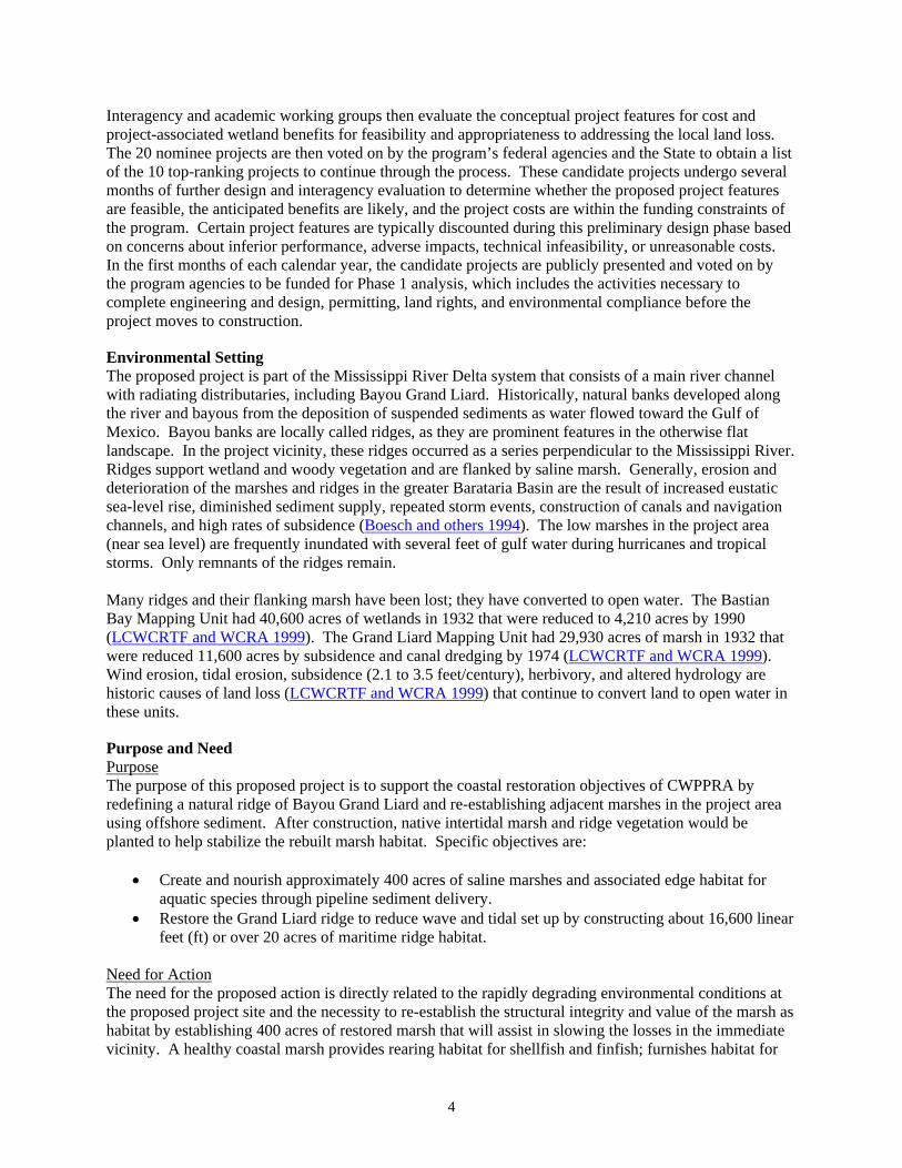
Project Location The proposed project is located in Plaquemines Parish, Louisiana near Triumph approximately 2 miles south of Louisiana Highway 23 (Figures 1 and 2). The proposed project area encompasses approximately 400 acres of saline marsh and open water (2007 Survey, Sasser and others 2008). The borrow area and pipeline corridor proposed for this project are located along and within the project boundary, and in two areas offshore of the project area.
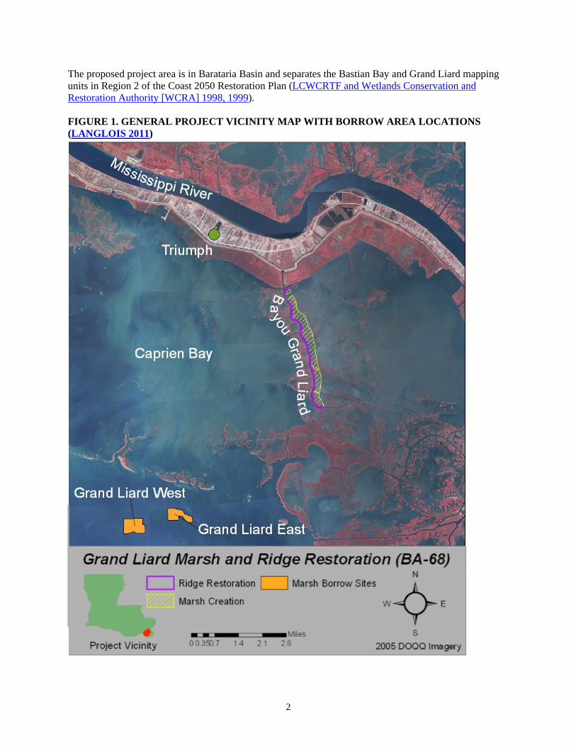
2
The proposed project area is in Barataria Basin and separates the Bastian Bay and Grand Liard mapping units in Region 2 of the Coast 2050 Restoration Plan (LCWCRTF and Wetlands Conservation and Restoration Authority [WCRA] 1998, 1999). FIGURE 1. GENERAL PROJECT VICINITY MAP WITH BORROW AREA LOCATIONS (LANGLOIS 2011)
3
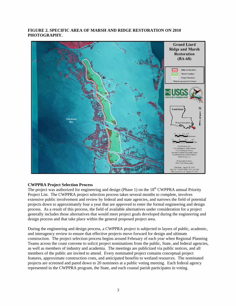
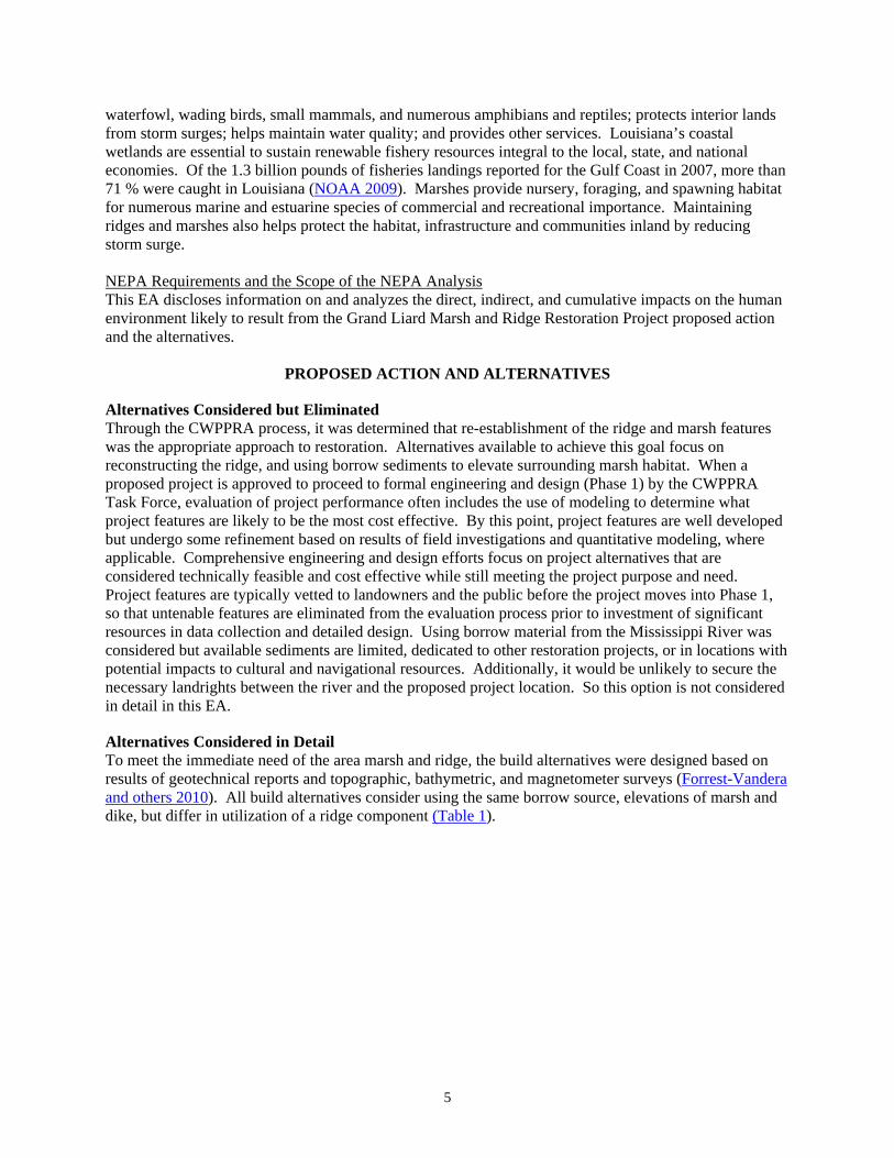
FIGURE 2. SPECIFIC AREA OF MARSH AND RIDGE RESTORATION ON 2010 PHOTOGRAPHY.
CWPPRA Project Selection Process The project was authorized for engineering and design (Phase 1) on the 18th CWPPRA annual Priority Project List. The CWPPRA project selection process takes several months to complete, involves extensive public involvement and review by federal and state agencies, and narrows the field of potential projects down to approximately four a year that are approved to enter the formal engineering and design process. As a result of this process, the field of available alternatives under consideration for a project generally includes those alternatives that would meet project goals developed during the engineering and design process and that take place within the general proposed project area. During the engineering and design process, a CWPPRA project is subjected to layers of public, academic, and interagency review to ensure that effective projects move forward for design and ultimate construction. The project selection process begins around February of each year when Regional Planning Teams across the coast convene to solicit project nominations from the public, State, and federal agencies, as well as members of industry and academia. The meetings are publicized via public notices, and all members of the public are invited to attend. Every nominated project contains conceptual project features, approximate construction costs, and anticipated benefits to wetland resources. The nominated projects are screened and pared down to 20 nominees at a public voting meeting. Each federal agency represented in the CWPPRA program, the State, and each coastal parish participates in voting.
4
Interagency and academic working groups then evaluate the conceptual project features for cost and project-associated wetland benefits for feasibility and appropriateness to addressing the local land loss. The 20 nominee projects are then voted on by the program’s federal agencies and the State to obtain a list of the 10 top-ranking projects to continue through the process. These candidate projects undergo several months of further design and interagency evaluation to determine whether the proposed project features are feasible, the anticipated benefits are likely, and the project costs are within the funding constraints of the program. Certain project features are typically discounted during this preliminary design phase based on concerns about inferior performance, adverse impacts, technical infeasibility, or unreasonable costs. In the first months of each calendar year, the candidate projects are publicly presented and voted on by the program agencies to be funded for Phase 1 analysis, which includes the activities necessary to complete engineering and design, permitting, land rights, and environmental compliance before the project moves to construction.
Environmental Setting The proposed project is part of the Mississippi River Delta system that consists of a main river channel with radiating distributaries, including Bayou Grand Liard. Historically, natural banks developed along the river and bayous from the deposition of suspended sediments as water flowed toward the Gulf of Mexico. Bayou banks are locally called ridges, as they are prominent features in the otherwise flat landscape. In the project vicinity, these ridges occurred as a series perpendicular to the Mississippi River. Ridges support wetland and woody vegetation and are flanked by saline marsh. Generally, erosion and deterioration of the marshes and ridges in the greater Barataria Basin are the result of increased eustatic sea-level rise, diminished sediment supply, repeated storm events, construction of canals and navigation channels, and high rates of subsidence (Boesch and others 1994). The low marshes in the project area (near sea level) are frequently inundated with several feet of gulf water during hurricanes and tropical storms. Only remnants of the ridges remain. Many ridges and their flanking marsh have been lost; they have converted to open water. The Bastian Bay Mapping Unit had 40,600 acres of wetlands in 1932 that were reduced to 4,210 acres by 1990 (LCWCRTF and WCRA 1999). The Grand Liard Mapping Unit had 29,930 acres of marsh in 1932 that were reduced 11,600 acres by subsidence and canal dredging by 1974 (LCWCRTF and WCRA 1999). Wind erosion, tidal erosion, subsidence (2.1 to 3.5 feet/century), herbivory, and altered hydrology are historic causes of land loss (LCWCRTF and WCRA 1999) that continue to convert land to open water in these units.
Purpose and Need Purpose The purpose of this proposed project is to support the coastal restoration objectives of CWPPRA by redefining a natural ridge of Bayou Grand Liard and re-establishing adjacent marshes in the project area using offshore sediment. After construction, native intertidal marsh and ridge vegetation would be planted to help stabilize the rebuilt marsh habitat. Specific objectives are:
Create and nourish approximately 400 acres of saline marshes and associated edge habitat for aquatic species through pipeline sediment delivery.
Restore the Grand Liard ridge to reduce wave and tidal set up by constructing about 16,600 linear feet (ft) or over 20 acres of maritime ridge habitat.
Need for Action The need for the proposed action is directly related to the rapidly degrading environmental conditions at the proposed project site and the necessity to re-establish the structural integrity and value of the marsh as habitat by establishing 400 acres of restored marsh that will assist in slowing the losses in the immediate vicinity. A healthy coastal marsh provides rearing habitat for shellfish and finfish; furnishes habitat for
5
waterfowl, wading birds, small mammals, and numerous amphibians and reptiles; protects interior lands from storm surges; helps maintain water quality; and provides other services. Louisiana’s coastal wetlands are essential to sustain renewable fishery resources integral to the local, state, and national economies. Of the 1.3 billion pounds of fisheries landings reported for the Gulf Coast in 2007, more than 71 % were caught in Louisiana (NOAA 2009). Marshes provide nursery, foraging, and spawning habitat for numerous marine and estuarine species of commercial and recreational importance. Maintaining ridges and marshes also helps protect the habitat, infrastructure and communities inland by reducing storm surge. NEPA Requirements and the Scope of the NEPA Analysis This EA discloses information on and analyzes the direct, indirect, and cumulative impacts on the human environment likely to result from the Grand Liard Marsh and Ridge Restoration Project proposed action and the alternatives.
PROPOSED ACTION AND ALTERNATIVES
Alternatives Considered but Eliminated Through the CWPPRA process, it was determined that re-establishment of the ridge and marsh features was the appropriate approach to restoration. Alternatives available to achieve this goal focus on reconstructing the ridge, and using borrow sediments to elevate surrounding marsh habitat. When a proposed project is approved to proceed to formal engineering and design (Phase 1) by the CWPPRA Task Force, evaluation of project performance often includes the use of modeling to determine what project features are likely to be the most cost effective. By this point, project features are well developed but undergo some refinement based on results of field investigations and quantitative modeling, where applicable. Comprehensive engineering and design efforts focus on project alternatives that are considered technically feasible and cost effective while still meeting the project purpose and need. Project features are typically vetted to landowners and the public before the project moves into Phase 1, so that untenable features are eliminated from the evaluation process prior to investment of significant resources in data collection and detailed design. Using borrow material from the Mississippi River was considered but available sediments are limited, dedicated to other restoration projects, or in locations with potential impacts to cultural and navigational resources. Additionally, it would be unlikely to secure the necessary landrights between the river and the proposed project location. So this option is not considered in detail in this EA.
Alternatives Considered in Detail To meet the immediate need of the area marsh and ridge, the build alternatives were designed based on results of geotechnical reports and topographic, bathymetric, and magnetometer surveys (Forrest-Vandera and others 2010). All build alternatives consider using the same borrow source, elevations of marsh and dike, but differ in utilization of a ridge component (Table 1).
6
TABLE 1. FEATURE DIFFERENCES OF ALTERNATIVES CONSIDERED
Alternative Marsh Ridge No action 160 existing acres exist that
with natural losses would be reduced to around 80 acres in 20 years.*
There is essentially no ridge currently. The remnant ridge is at marsh elevation, which is expected to be lost to open water in 20 years due to erosion.
Preferred - Build 1 Approximately 400 acres would be created and nourished, much of which would remain after 20 years.*
Approximately 20 acres of ridge would be restored and maintained for 20 years.
Build 2 Approximately 450 acres would be created and nourished, much of which would remain after 20 years.
0 acres created.
*All numbers are approximations from estimates in Fitzgerald and others 2011, NMFS 2008, and subsequent wetland value assessments and project design documents.
The No-Action Alternative NEPA refers to the no-action alternative as the continuation of baseline conditions without implementation of the proposed action. Evaluation of the no-action alternative is required by CEQ regulations. Under this alternative, no steps would be taken to restore the Grand Liard marsh and ridge habitat. Preferred Alternative - Build Alternative 1 The proposed action is the preferred alternative, which maximizes time the marsh creation area would be at a healthy marsh elevation for 20 years after construction. As described below, the alternative consists of building marsh and ridge along Bayou Grand Liard (Figures 1 and 2) utilizing an identified offshore borrow area that contains appropriate construction material. Ridge The ridge construction would be approximately 16,600 linear ft in length, with a crown width averaging at least 20 ft, bottom width of approximately 100 ft for a total ridge area of approximately 20 acres. The initial ridge elevation would be +5.0 ft (Figure 3). This alternative considers temporarily surrounding the marsh creation area with containment dikes and ridge to retain hydraulically placed marsh fill material. The ridge feature is intended to recreate a historically existing landscape feature. Grand Liard Bayou was historically an interdistributary channel of the Mississippi River; these areas are characterized as having higher-elevation channel banks and adjacent ridges created by overbank flooding. Such elevated areas previously supported woody vegetation and provided unique habitat for a variety of bird and mammals. Additionally, this elevated landscape feature would provide structural protection for adjacent marshes. Marsh The marsh fill elevation was designed to maximize the time the marsh fill would be within the intertidal zone over the twenty-year project life. In settlement analyses based on soil borings, this height was predicted when two sediment lifts were utilized during construction of the marsh fill area. The marsh would initially be constructed to approximately +3.5 ft (Figure 3). The second lift would provide a +2.8 ft to +3.5 ft elevation, depending upon fill location. The elevation is comparable to that of healthy marsh in the vicinity (Fitzgerald and others 2011). Containment dikes (Figure 4) would be necessary along the
7
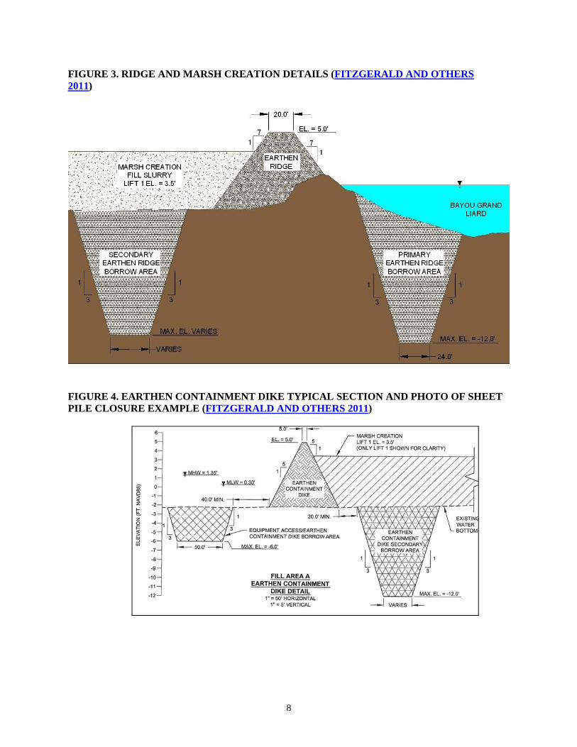
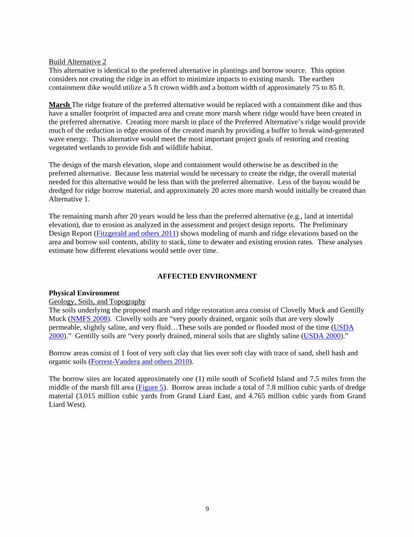
perimeter to contain sediments and allow settlement, except where the ridge is constructed that would contain sediments. Some areas are too deep to construct containment dikes; in these areas, sheet pile closures would be used to provide containment for marsh fill. Multiple marsh construction units would be used, because there are deep channels that bisect the project area that would be impractical, if possible, to fill. To maintain those waterways and provide the most marsh habitat with available sediments, containment dikes would be used to create four separate construction cells adjacent to those waterways. The dikes would be gapped as needed to provide tidal exchange and drainage after construction and consolidation of the marsh. Plantings To allow for soil salinities and elevations to stabilize, planting would occur over several years. Upon dewatering and compaction of the marsh platform, the marsh platform would be planted with indigenous intertidal vegetation that would help stabilize the sediments such as, but not limited to, smooth cordgrass (Spartina alterniflora cv. Vermilion). Marsh and ridge acreage would be planted with a variety of bare-root plugs, seeds and / or seedlings of appropriate species that would increase plant diversity in the area. Planting plans depend on final site conditions and species availability. The species to be planted are therefore subject to change. Herbaceous and woody species that may be planted are smooth cordgrass, gulf cordgrass (Spartina spartinae), seashore paspalum (Paspalum vaginatum), wax myrtle (Myrica cerifera), mulberry (Morus sp.), baccharis (Baccharis halimifolia), marsh elder (Iva frutescens), and yaupon (Ilex vomitoria). Should invasive woody species, such as the Chinese tallow tree (Triadica sebifera) occur along the created ridge, they would be removed manually or by herbicide. Borrow For equipment to access the shallow Bayou Grand Liard for project construction, some sediment would be removed from Bayou Grand Liard, the eastern remnant bayou, and interior borrow areas. Materials excavated would be used beneficially for ridge or containment dike construction. Additional materials would be needed to construct the perimeter containment dikes. Any materials removed from the marsh creation area would subsequently be filled with the marsh fill (offshore) borrow materials. Marsh features described above would be built from sediments from two offshore borrow areas (containing an estimated 7.8 million cubic yards) and sediments dredged for access to the site (Forrest-Vandera and others 2010). Initial offshore investigations within a 15 mile radius of the project area identified 6 areas of potential suitable borrow material. Coastal Planning and Engineering, Inc conducted surveys of these areas that included seismic profiling, sidescan sonar, bathymetric, magnetometer, and vibracore data collection (Forrest-Vandera and others 2010). Two offshore sediment resource areas were identified for further investigation that included cultural resource surveys, geotechnical surveys, geophysical modeling, and borrow area design (Forrest-Vandera and others 2010).
8
FIGURE 3. RIDGE AND MARSH CREATION DETAILS (FITZGERALD AND OTHERS 2011)
FIGURE 4. EARTHEN CONTAINMENT DIKE TYPICAL SECTION AND PHOTO OF SHEET PILE CLOSURE EXAMPLE (FITZGERALD AND OTHERS 2011)
9
Build Alternative 2 This alternative is identical to the preferred alternative in plantings and borrow source. This option considers not creating the ridge in an effort to minimize impacts to existing marsh. The earthen containment dike would utilize a 5 ft crown width and a bottom width of approximately 75 to 85 ft. Marsh The ridge feature of the preferred alternative would be replaced with a containment dike and thus have a smaller footprint of impacted area and create more marsh where ridge would have been created in the preferred alternative. Creating more marsh in place of the Preferred Alternative’s ridge would provide much of the reduction in edge erosion of the created marsh by providing a buffer to break wind-generated wave energy. This alternative would meet the most important project goals of restoring and creating vegetated wetlands to provide fish and wildlife habitat. The design of the marsh elevation, slope and containment would otherwise be as described in the preferred alternative. Because less material would be necessary to create the ridge, the overall material needed for this alternative would be less than with the preferred alternative. Less of the bayou would be dredged for ridge borrow material, and approximately 20 acres more marsh would initially be created than Alternative 1. The remaining marsh after 20 years would be less than the preferred alternative (e.g., land at intertidal elevation), due to erosion as analyzed in the assessment and project design reports. The Preliminary Design Report (Fitzgerald and others 2011) shows modeling of marsh and ridge elevations based on the area and borrow soil contents, ability to stack, time to dewater and existing erosion rates. These analyses estimate how different elevations would settle over time.
AFFECTED ENVIRONMENT
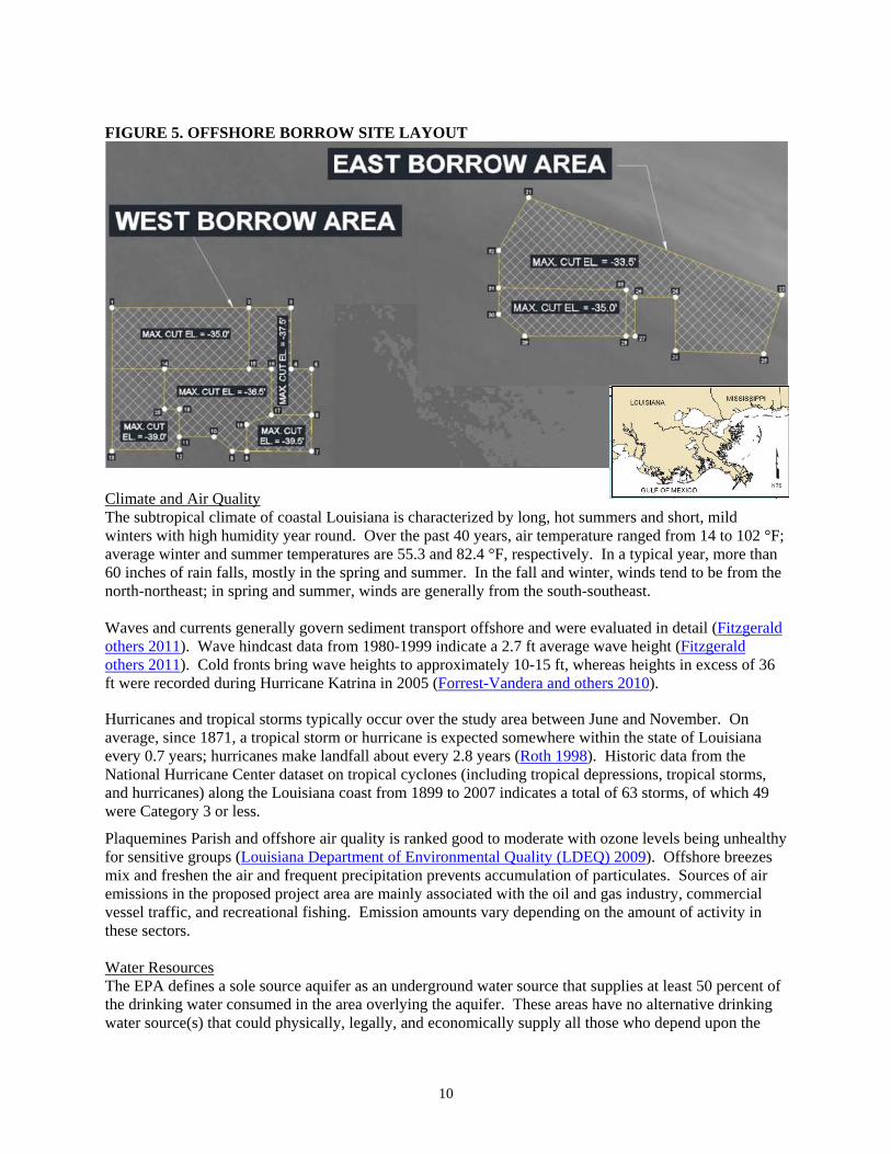
Physical Environment Geology, Soils, and Topography The soils underlying the proposed marsh and ridge restoration area consist of Clovelly Muck and Gentilly Muck (NMFS 2008). Clovelly soils are “very poorly drained, organic soils that are very slowly permeable, slightly saline, and very fluid…These soils are ponded or flooded most of the time (USDA 2000).” Gentilly soils are “very poorly drained, mineral soils that are slightly saline (USDA 2000).” Borrow areas consist of 1 foot of very soft clay that lies over soft clay with trace of sand, shell hash and organic soils (Forrest-Vandera and others 2010). The borrow sites are located approximately one (1) mile south of Scofield Island and 7.5 miles from the middle of the marsh fill area (Figure 5). Borrow areas include a total of 7.8 million cubic yards of dredge material (3.015 million cubic yards from Grand Liard East, and 4.765 million cubic yards from Grand Liard West).
10
FIGURE 5. OFFSHORE BORROW SITE LAYOUT
Climate and Air Quality The subtropical climate of coastal Louisiana is characterized by long, hot summers and short, mild winters with high humidity year round. Over the past 40 years, air temperature ranged from 14 to 102 °F; average winter and summer temperatures are 55.3 and 82.4 °F, respectively. In a typical year, more than 60 inches of rain falls, mostly in the spring and summer. In the fall and winter, winds tend to be from the north-northeast; in spring and summer, winds are generally from the south-southeast. Waves and currents generally govern sediment transport offshore and were evaluated in detail (Fitzgerald others 2011). Wave hindcast data from 1980-1999 indicate a 2.7 ft average wave height (Fitzgerald others 2011). Cold fronts bring wave heights to approximately 10-15 ft, whereas heights in excess of 36 ft were recorded during Hurricane Katrina in 2005 (Forrest-Vandera and others 2010).
Hurricanes and tropical storms typically occur over the study area between June and November. On average, since 1871, a tropical storm or hurricane is expected somewhere within the state of Louisiana every 0.7 years; hurricanes make landfall about every 2.8 years (Roth 1998). Historic data from the National Hurricane Center dataset on tropical cyclones (including tropical depressions, tropical storms, and hurricanes) along the Louisiana coast from 1899 to 2007 indicates a total of 63 storms, of which 49 were Category 3 or less.
Plaquemines Parish and offshore air quality is ranked good to moderate with ozone levels being unhealthy for sensitive groups (Louisiana Department of Environmental Quality (LDEQ) 2009). Offshore breezes mix and freshen the air and frequent precipitation prevents accumulation of particulates. Sources of air emissions in the proposed project area are mainly associated with the oil and gas industry, commercial vessel traffic, and recreational fishing. Emission amounts vary depending on the amount of activity in these sectors. Water Resources The EPA defines a sole source aquifer as an underground water source that supplies at least 50 percent of the drinking water consumed in the area overlying the aquifer. These areas have no alternative drinking water source(s) that could physically, legally, and economically supply all those who depend upon the
11
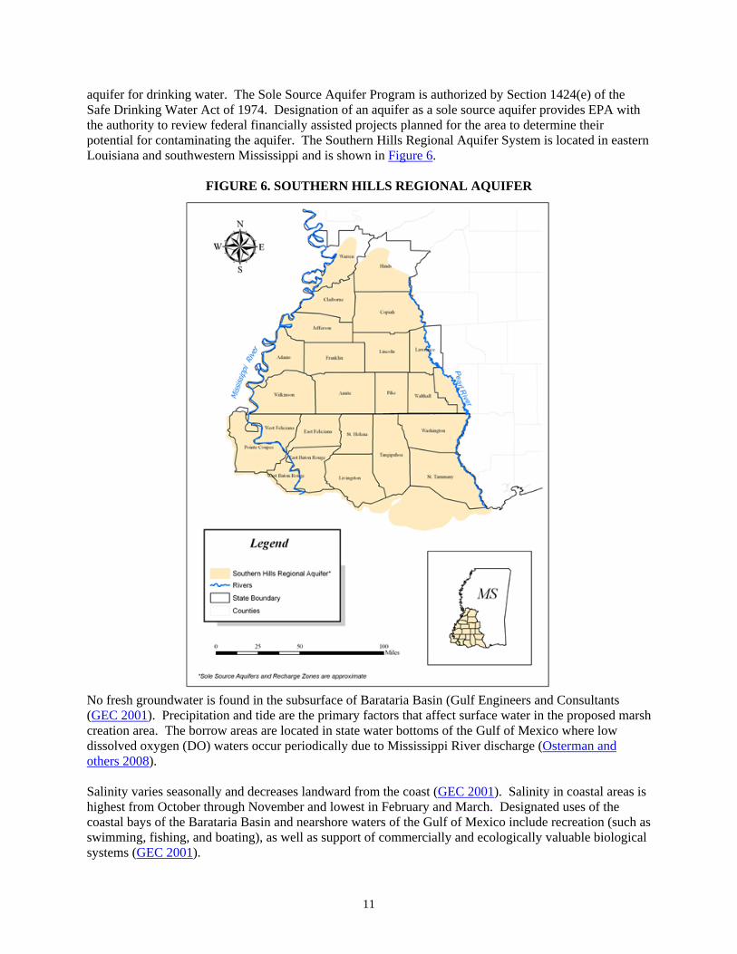
aquifer for drinking water. The Sole Source Aquifer Program is authorized by Section 1424(e) of the Safe Drinking Water Act of 1974. Designation of an aquifer as a sole source aquifer provides EPA with the authority to review federal financially assisted projects planned for the area to determine their potential for contaminating the aquifer. The Southern Hills Regional Aquifer System is located in eastern Louisiana and southwestern Mississippi and is shown in Figure 6.
FIGURE 6. SOUTHERN HILLS REGIONAL AQUIFER
No fresh groundwater is found in the subsurface of Barataria Basin (Gulf Engineers and Consultants (GEC 2001). Precipitation and tide are the primary factors that affect surface water in the proposed marsh creation area. The borrow areas are located in state water bottoms of the Gulf of Mexico where low dissolved oxygen (DO) waters occur periodically due to Mississippi River discharge (Osterman and others 2008). Salinity varies seasonally and decreases landward from the coast (GEC 2001). Salinity in coastal areas is highest from October through November and lowest in February and March. Designated uses of the coastal bays of the Barataria Basin and nearshore waters of the Gulf of Mexico include recreation (such as swimming, fishing, and boating), as well as support of commercially and ecologically valuable biological systems (GEC 2001).
12
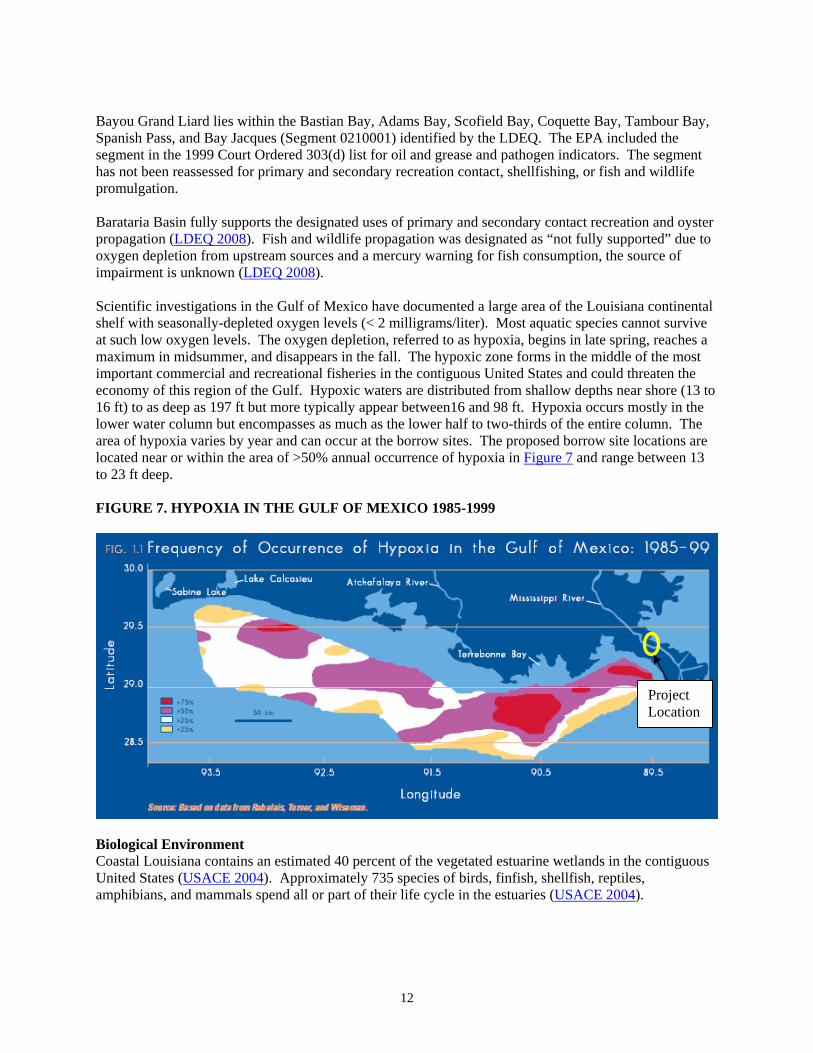
Bayou Grand Liard lies within the Bastian Bay, Adams Bay, Scofield Bay, Coquette Bay, Tambour Bay, Spanish Pass, and Bay Jacques (Segment 0210001) identified by the LDEQ. The EPA included the segment in the 1999 Court Ordered 303(d) list for oil and grease and pathogen indicators. The segment has not been reassessed for primary and secondary recreation contact, shellfishing, or fish and wildlife promulgation. Barataria Basin fully supports the designated uses of primary and secondary contact recreation and oyster propagation (LDEQ 2008). Fish and wildlife propagation was designated as “not fully supported” due to oxygen depletion from upstream sources and a mercury warning for fish consumption, the source of impairment is unknown (LDEQ 2008). Scientific investigations in the Gulf of Mexico have documented a large area of the Louisiana continental shelf with seasonally-depleted oxygen levels (< 2 milligrams/liter). Most aquatic species cannot survive at such low oxygen levels. The oxygen depletion, referred to as hypoxia, begins in late spring, reaches a maximum in midsummer, and disappears in the fall. The hypoxic zone forms in the middle of the most important commercial and recreational fisheries in the contiguous United States and could threaten the economy of this region of the Gulf. Hypoxic waters are distributed from shallow depths near shore (13 to 16 ft) to as deep as 197 ft but more typically appear between16 and 98 ft. Hypoxia occurs mostly in the lower water column but encompasses as much as the lower half to two-thirds of the entire column. The area of hypoxia varies by year and can occur at the borrow sites. The proposed borrow site locations are located near or within the area of >50% annual occurrence of hypoxia in Figure 7 and range between 13 to 23 ft deep. FIGURE 7. HYPOXIA IN THE GULF OF MEXICO 1985-1999
Biological Environment Coastal Louisiana contains an estimated 40 percent of the vegetated estuarine wetlands in the contiguous United States (USACE 2004). Approximately 735 species of birds, finfish, shellfish, reptiles, amphibians, and mammals spend all or part of their life cycle in the estuaries (USACE 2004).
Project Location
13
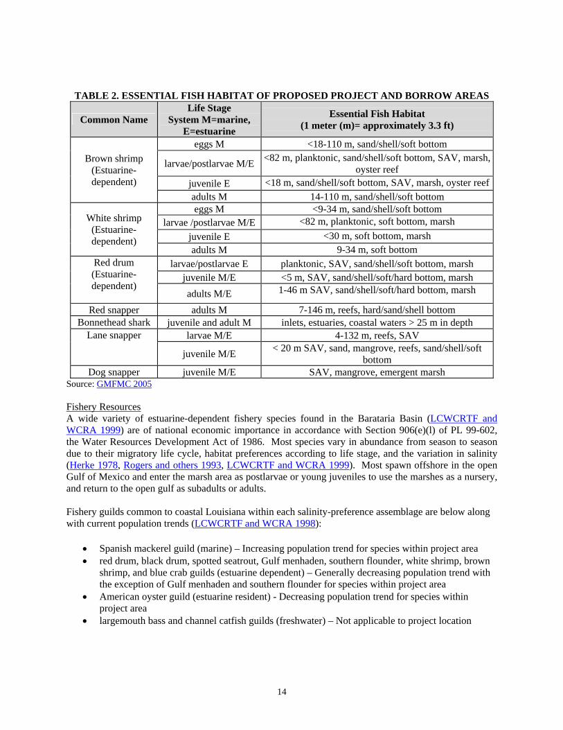
Vegetation Resources Based on U.S. Geological Survey habitat mapping, the current marsh area is 71 acres (NMFS 2011). Ridge habitat is higher than marsh elevation and supports woody species, such as trees and shrubs. Trace amounts (<1 acre) of ridge are currently in the project area. The majority of the vegetation is smooth cordgrass. Other species present are saltmeadow cordgrass (Spartina patens), and big cordgrass (Spartina cynosuroides) (Sasser and others 2008). Common names are from the U.S. Department of Agriculture PLANTS Database. Widespread submerged aquatic vegetation (SAV) was observed in the area April 2008 (NMFS 2008). No vegetation is present in the borrow area. Aquatic and Benthic Habitats The project area is primarily shallow (<1.5 ft) open-water and benthic habitat (NMFS 2008). The borrow area is benthic habitat under open marine water column. Oysters are productive in the bayou (James Wray, Personal Communication, CPRA). Benthic habitats near the marsh area support bacteria, fungi, microalgae, meiofauna, and microfauna, such as mollusks, polychaetes, decapods, and nematodes (Conner and Day 1987; Day and others 1989). The benthic community supports higher levels of the food chain, such as shrimp and demersal fish (Conner and Day 1987). Substrate quality strongly influences the distribution of benthic fauna. Other variables affecting the distribution of benthic organisms include water depth, salinity, illumination, food availability, currents, and tides. Essential Fish Habitat (EFH) The proposed project area contains EFH as designated by the Gulf of Mexico Fisheries Management Council (GMFMC) for species that are federally managed under the Magnuson-Stevens Fishery Conservation and Management Act, P.L. 104-297; 16 U.S.C. 1801 et seq. (Magnuson-Stevens Act). Categories of EFH in the project area include estuarine emergent wetlands, mud substrates, SAV, and estuarine water column (GMFMC 2005). Table 2 lists the EFH, federally managed species, and their life stages expected to occur in the proposed project and borrow areas. Red drum, brown shrimp and white shrimp are estuarine-dependent species. In the Barataria Basin, the estuarine-dependent assemblage, including white and brown shrimp and red drum, has shown decreasing trends over the last 10 to 20 years (LCWCRTF and WCRA 1999). These species migrate through tidal passes during their post-larval life stage and depend on the estuarine environment for survival and reproduction. Shrimp are prey species for other federally managed fish and crustaceans (GMFMC 1998).
14
TABLE 2. ESSENTIAL FISH HABITAT OF PROPOSED PROJECT AND BORROW AREAS
Common Name Life Stage
System M=marine, E=estuarine
Essential Fish Habitat (1 meter (m)= approximately 3.3 ft)
Brown shrimp (Estuarine-dependent)
eggs M <18-110 m, sand/shell/soft bottom
larvae/postlarvae M/E <82 m, planktonic, sand/shell/soft bottom, SAV, marsh,
oyster reef
juvenile E <18 m, sand/shell/soft bottom, SAV, marsh, oyster reef
adults M 14-110 m, sand/shell/soft bottom
White shrimp (Estuarine-dependent)
eggs M <9-34 m, sand/shell/soft bottom larvae /postlarvae M/E <82 m, planktonic, soft bottom, marsh
juvenile E <30 m, soft bottom, marsh adults M 9-34 m, soft bottom
Red drum (Estuarine-dependent)
larvae/postlarvae E planktonic, SAV, sand/shell/soft bottom, marsh juvenile M/E <5 m, SAV, sand/shell/soft/hard bottom, marsh
adults M/E 1-46 m SAV, sand/shell/soft/hard bottom, marsh
Red snapper adults M 7-146 m, reefs, hard/sand/shell bottom Bonnethead shark juvenile and adult M inlets, estuaries, coastal waters > 25 m in depth
Lane snapper larvae M/E 4-132 m, reefs, SAV
juvenile M/E < 20 m SAV, sand, mangrove, reefs, sand/shell/soft
bottom Dog snapper juvenile M/E SAV, mangrove, emergent marsh
Source: GMFMC 2005 Fishery Resources A wide variety of estuarine-dependent fishery species found in the Barataria Basin (LCWCRTF and WCRA 1999) are of national economic importance in accordance with Section 906(e)(l) of PL 99-602, the Water Resources Development Act of 1986. Most species vary in abundance from season to season due to their migratory life cycle, habitat preferences according to life stage, and the variation in salinity (Herke 1978, Rogers and others 1993, LCWCRTF and WCRA 1999). Most spawn offshore in the open Gulf of Mexico and enter the marsh area as postlarvae or young juveniles to use the marshes as a nursery, and return to the open gulf as subadults or adults. Fishery guilds common to coastal Louisiana within each salinity-preference assemblage are below along with current population trends (LCWCRTF and WCRA 1998):
Spanish mackerel guild (marine) – Increasing population trend for species within project area red drum, black drum, spotted seatrout, Gulf menhaden, southern flounder, white shrimp, brown
shrimp, and blue crab guilds (estuarine dependent) – Generally decreasing population trend with the exception of Gulf menhaden and southern flounder for species within project area
American oyster guild (estuarine resident) - Decreasing population trend for species within project area
largemouth bass and channel catfish guilds (freshwater) – Not applicable to project location
15
Marine Mammal Resources Marine mammals that occur in Louisiana waters include the blue, sei, sperm and fin whales, the dolphin, and the endangered West Indian manatee. Whales were found to be “unlikely to occur in the project area (NMFS 2010)”, so are not further discussed. West Indian manatees may be found in Lakes Pontchartrain and Maurepas, and Louisiana coastal waters during the warmer months, and their occurrences appear to be increasing in Louisiana. Based on the proposed project location, it is unlikely that West Indian manatees would occur in the project area. Dolphins are common along the shore. Dolphins follow schooling fishes, such as menhaden that are prey, and seek food and refuge in interior bay waters.
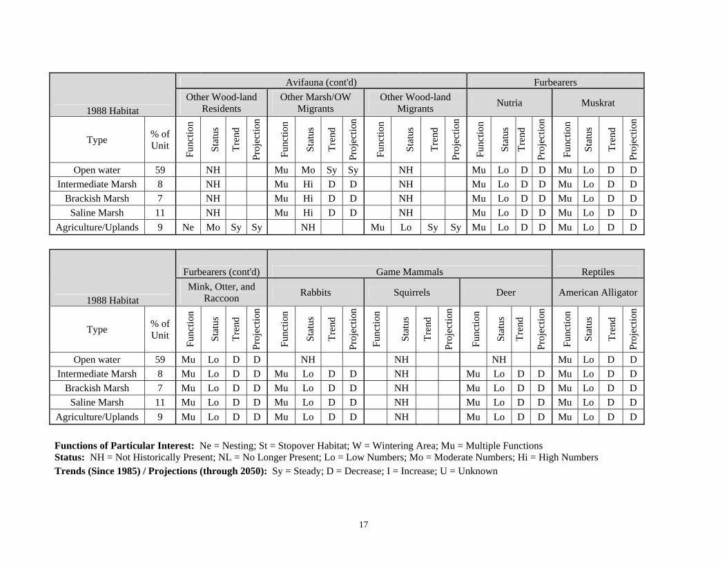
Migratory Bird Resources Waterbirds were specifically considered pursuant to the Migratory Bird Treaty Act. No colonies of colonial nesting waterbirds have been observed in the proposed project area, but could occur (USFWS 2011). This resource includes herons, egrets, night-herons, ibis, roseate spoonbills, anhingas, and/or cormorants. Wildlife Resources Louisiana’s coastal zone supports 19 percent of the United States’ winter population for 14 species of ducks and geese. The North American Waterfowl Management Plan identified coastal Louisiana as one of the most important regions for the maintenance of continental waterfowl populations in North America (USACE 2004). The Barataria Basin has 411 species of birds; 60 species of reptiles and amphibians; 8 species of bats; and 11 species of small mammals, armadillo and marine mammals (Connor and Day 1987). The habitat of the proposed project area is unlikely to support some of these species due to the lack of woody and freshwater habitats. The basin is located at the bottom of the Mississippi Flyway, and birds from central and northern North America start to converge in the fall. Waterfowl populations in the Barataria basins have declined as marsh converts to open water (LCWCRTF and WCRA 1999). Table 3 lists the wildlife species and/or species groups prominent (LCWCRTF and WCRA 1998) within coastal Louisiana along with the habitat function, status, trend, and projection within the project area.
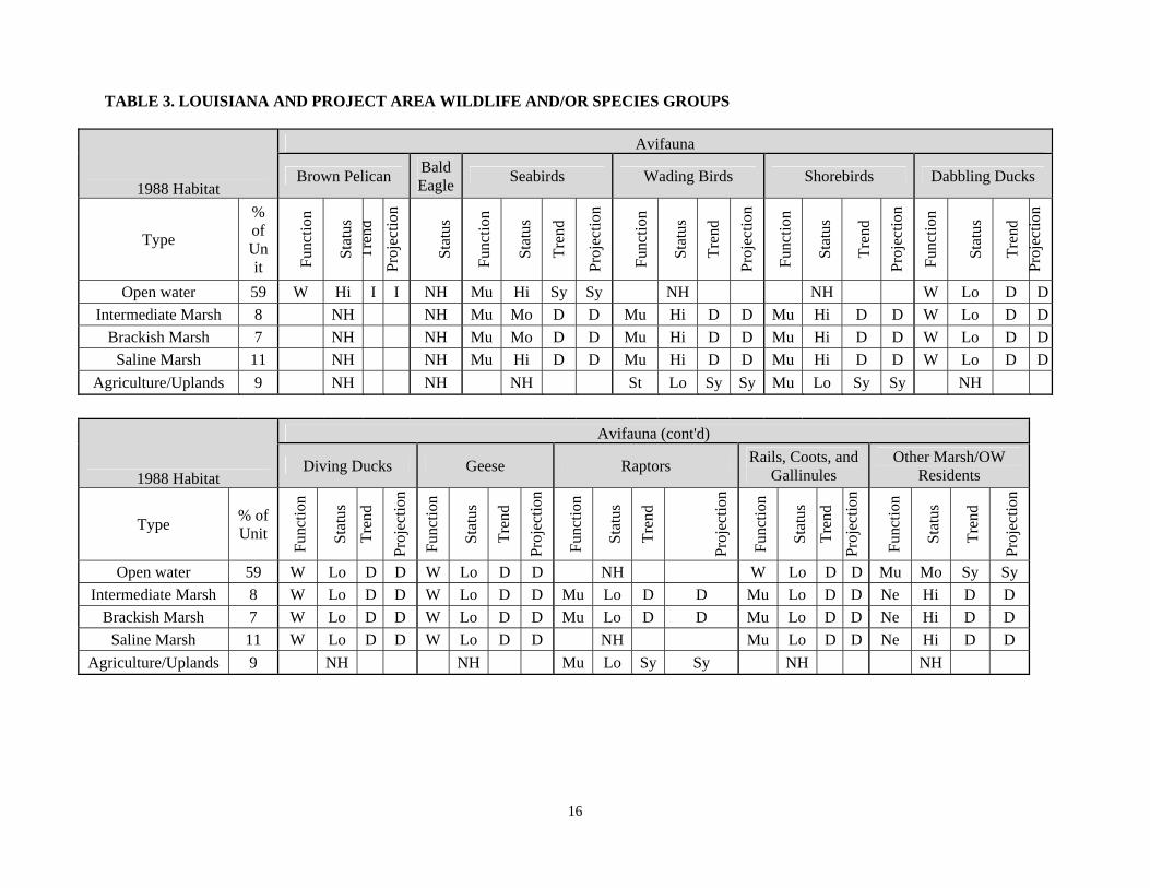
16
TABLE 3. LOUISIANA AND PROJECT AREA WILDLIFE AND/OR SPECIES GROUPS
1988 Habitat
Avifauna
Brown Pelican Bald Eagle
Seabirds Wading Birds Shorebirds Dabbling Ducks
Type
% of Unit F
unct
ion
Sta
tus
Tre
nd
Pro
ject
ion
Sta
tus
Fun
ctio
n
Sta
tus
Tre
nd
Pro
ject
ion
Fun
ctio
n
Sta
tus
Tre
nd
Pro
ject
ion
Fun
ctio
n
Sta
tus
Tre
nd
Pro
ject
ion
Fun
ctio
n
Sta
tus
Tre
nd
Pro
ject
ion
Open water 59 W Hi I I NH Mu Hi Sy Sy NH NH W Lo D D
Intermediate Marsh 8 NH NH Mu Mo D D Mu Hi D D Mu Hi D D W Lo D D
Brackish Marsh 7 NH NH Mu Mo D D Mu Hi D D Mu Hi D D W Lo D D
Saline Marsh 11 NH NH Mu Hi D D Mu Hi D D Mu Hi D D W Lo D D
Agriculture/Uplands 9 NH NH NH St Lo Sy Sy Mu Lo Sy Sy NH
1988 Habitat
Avifauna (cont'd)
Diving Ducks Geese Raptors Rails, Coots, and
Gallinules Other Marsh/OW
Residents
Type % of Unit
Fun
ctio
n
Sta
tus
Tre
nd
Pro
ject
ion
Fun
ctio
n
Sta
tus
Tre
nd
Pro
ject
ion
Fun
ctio
n
Sta
tus
Tre
nd
Pro
ject
ion
Fun
ctio
n
Sta
tus
Tre
nd
Pro
ject
ion
Fun
ctio
n
Sta
tus
Tre
nd
Pro
ject
ion
Open water 59 W Lo D D W Lo D D NH W Lo D D Mu Mo Sy Sy
Intermediate Marsh 8 W Lo D D W Lo D D Mu Lo D D Mu Lo D D Ne Hi D D
Brackish Marsh 7 W Lo D D W Lo D D Mu Lo D D Mu Lo D D Ne Hi D D
Saline Marsh 11 W Lo D D W Lo D D NH Mu Lo D D Ne Hi D D
Agriculture/Uplands 9 NH NH Mu Lo Sy Sy NH NH
17
1988 Habitat
Avifauna (cont'd) Furbearers
Other Wood-land Residents
Other Marsh/OW Migrants
Other Wood-land Migrants
Nutria Muskrat
Type % of Unit
Fun
ctio
n
Sta
tus
Tre
nd
Pro
ject
ion
Fun
ctio
n
Sta
tus
Tre
nd
Pro
ject
ion
Fun
ctio
n
Sta
tus
Tre
nd
Pro
ject
ion
Fun
ctio
n
Sta
tus
Tre
nd
Pro
ject
ion
Fun
ctio
n
Sta
tus
Tre
nd
Pro
ject
ion
Open water 59 NH Mu Mo Sy Sy NH Mu Lo D D Mu Lo D D
Intermediate Marsh 8 NH Mu Hi D D NH Mu Lo D D Mu Lo D D
Brackish Marsh 7 NH Mu Hi D D NH Mu Lo D D Mu Lo D D
Saline Marsh 11 NH Mu Hi D D NH Mu Lo D D Mu Lo D D
Agriculture/Uplands 9 Ne Mo Sy Sy NH Mu Lo Sy Sy Mu Lo D D Mu Lo D D
1988 Habitat
Furbearers (cont'd) Game Mammals Reptiles
Mink, Otter, and Raccoon
Rabbits Squirrels Deer American Alligator
Type % of Unit
Fun
ctio
n
Sta
tus
Tre
nd
Pro
ject
ion
Fun
ctio
n
Sta
tus
Tre
nd
Pro
ject
ion
Fun
ctio
n
Sta
tus
Tre
nd
Pro
ject
ion
Fun
ctio
n
Sta
tus
Tre
nd
Pro
ject
ion
Fun
ctio
n
Sta
tus
Tre
nd
Pro
ject
ion
Open water 59 Mu Lo D D NH NH NH Mu Lo D D
Intermediate Marsh 8 Mu Lo D D Mu Lo D D NH Mu Lo D D Mu Lo D D
Brackish Marsh 7 Mu Lo D D Mu Lo D D NH Mu Lo D D Mu Lo D D
Saline Marsh 11 Mu Lo D D Mu Lo D D NH Mu Lo D D Mu Lo D D
Agriculture/Uplands 9 Mu Lo D D Mu Lo D D NH Mu Lo D D Mu Lo D D
Functions of Particular Interest: Ne = Nesting; St = Stopover Habitat; W = Wintering Area; Mu = Multiple Functions Status: NH = Not Historically Present; NL = No Longer Present; Lo = Low Numbers; Mo = Moderate Numbers; Hi = High Numbers Trends (Since 1985) / Projections (through 2050): Sy = Steady; D = Decrease; I = Increase; U = Unknown
18
Threatened and Endangered Species Loggerhead, Kemp’s ridley, hawksbill, leatherback, and green sea turtles occur in Louisiana. Green sea turtles may be in the borrow area while migrating between their nesting and foraging sites in Florida and Texas. Major threats to sea turtles in the U.S. include destruction and alteration of nesting and foraging habitats; incidental capture in commercial and recreational fisheries (NOAAa 2012); marine debris (NOAAb 2012); and vessel strikes. They feed on phytoplankton, zooplankton, SAV, and small fish. Kemp’s ridley nest in Mexico and immature individuals are believed to stay in shallow, warm, nearshore waters in the northern Gulf of Mexico. They forage for crabs, mollusks, shrimp, and small fish. Loggerhead sea turtles occur in coastal and marine areas along the margins of the Atlantic, Pacific, and Indian Oceans. Their major threats are direct take, incidental capture in fisheries, and loss of habitat. The loggerhead turtle is the most abundant species of U.S. sea turtles and have a complex life history that is highly migratory. No sea turtle nesting is known to occur in the vicinity of the project. Gulf sturgeon and smalltooth sawfish may occur in the vicinity of the project area or borrow areas. Threatened or endangered marine mammals are not known to occur in the vicinity of the project, but those that occur in Louisiana are the blue, sei, sperm and fin whales and the West Indian manatee. The West Indian manatee may be found in lakes Pontchartrain and Maurepas, and the Louisiana coastal waters during the warmer months, and their occurrences appear to be increasing in Louisiana. Based on the proposed project location, it is unlikely that West Indian manatees would occur in the project area.
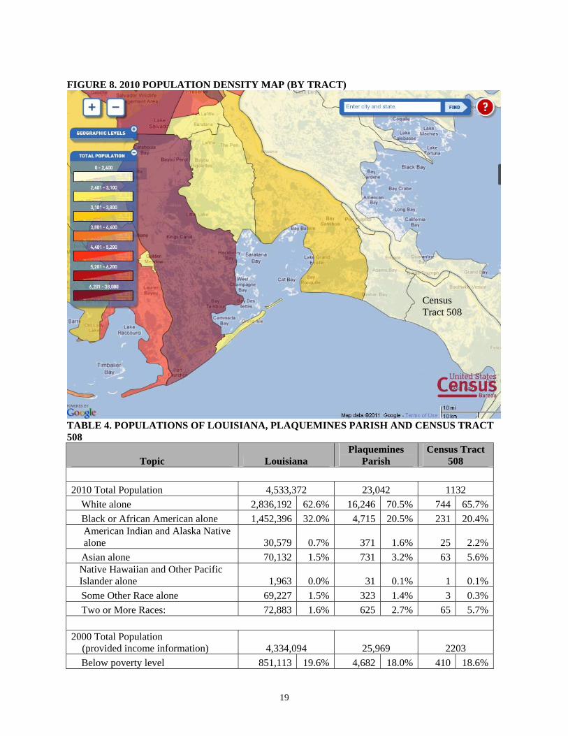
Cultural Resources Historic, Prehistoric, and Native American Resources Terrestrial Cultural Resources Reconnaissance terrestrial cultural resource investigations were conducted for the marsh creation project area by Arcadis (2011). The Louisiana State Historic Preservation Office (SHPO) reviewed the investigations and concurred that there are no historic properties to be impacted by the proposed project (SHPO 2011). Submerged Cultural Resources A cultural resource report including area surveys completed by Tidewater Atlantic Research (CPE 2010) indicated potential submerged cultural resources in the vicinity of the proposed borrow area. The results of the magnetic, acoustic and seismic data analyses from that report were used to delineate the proposed borrow areas. The proposed borrow areas include a 300-ft buffer around areas of potential submerged cultural resources to avoid those potential resources (CPE 2010). SHPO has concurred that project implementation, including borrow area excavation, would not affect known or potential cultural resources. Socioeconomics (Income and Environmental Justice) The population of Plaquemines Parish is 23,042 (U.S. Census 2010). This is 20% less than prior to Hurricanes Katrina and Rita in 2005 that adversely impacted the area (Plaquemines Parish Government 2011). The nearest towns and roads are 1 mile north of the proposed project area. The project site is contained within Census Tract 508 in Plaquemines Parish that extends southeast towards Venice on the western side of the Mississippi River. Figure 8 provides the general population distribution for the area. Table 4 provides population/poverty data for Census Tract 508, Plaquemines Parish, and Louisiana.
19
FIGURE 8. 2010 POPULATION DENSITY MAP (BY TRACT)
TABLE 4. POPULATIONS OF LOUISIANA, PLAQUEMINES PARISH AND CENSUS TRACT 508
Topic Louisiana Plaquemines
Parish Census Tract
508
2010 Total Population 4,533,372 23,042 1132
White alone 2,836,192 62.6% 16,246 70.5% 744 65.7%
Black or African American alone 1,452,396 32.0% 4,715 20.5% 231 20.4%American Indian and Alaska Native alone 30,579 0.7% 371 1.6% 25 2.2%
Asian alone 70,132 1.5% 731 3.2% 63 5.6%Native Hawaiian and Other Pacific Islander alone 1,963 0.0% 31 0.1% 1 0.1%
Some Other Race alone 69,227 1.5% 323 1.4% 3 0.3%
Two or More Races: 72,883 1.6% 625 2.7% 65 5.7%
2000 Total Population (provided income information) 4,334,094 25,969 2203
Below poverty level 851,113 19.6% 4,682 18.0% 410 18.6%
Census Tract 508
20
Land Use and Infrastructure Oil/natural gas, and maritime transport activity is prominent throughout coastal Louisiana. Oil and gas pipelines lay throughout the basin as active or remnant conveyance of this industry. The Mississippi River north of the proposed project area is the main source of shipping navigation for much of the nation. The proposed project area is accessible only to shallow draft boats. The marshes and bayous of Barataria Basin are used for recreation, such as hunting, fishing and birding, by locals and residents of the Greater New Orleans Metropolitan area. Industries of the area are primarily agriculture, fishing and hunting (24%), transportation, storage and utilities (12%), retail (11%), and construction (10.5%) (U.S. Census 2000). There are approximately 25 oyster leases within the project area. These leases are let by the State of Louisiana to private entities for oyster production (James Wray, personal com, CPRA). The total leased area is approximately 300 acres. The Plaquemines Parish Master Plan (http://www.plaqueminesmasterplan.com) identifies the current land use of the project area as undeveloped or water (Appendix A). Hazardous, Toxic, and Radioactive Wastes Magnetometer surveys were conducted in the proposed marsh and ridge creation area. Six pipelines were verified and two 4-inch diameter lines were surveyed and other anomalies detected (Fitzgerald and others 2011). Hazardous, toxic, and radioactive waste (HTRW) status of the proposed project area was investigated and is recorded in the October 2011 HTRW Analysis for Bayou Grand Liard, which is incorporated by reference. NMFS personnel conducted a site investigation of the project area. There were no signs of HTRW problems, such as dead or discolored vegetation, stained soil, chemical sheens or odors, or dead or dying fish, amphibians, reptiles, or mammals, or discarded drums, tanks, or chemical containers. Based on review of applicable federal and state regulatory agency records, historical records, interviews with persons knowledgeable about the subject property, and a physical site investigation, NMFS, through this analysis, has discovered no evidence of HTRW issues. Noise The proposed marsh creation area is remote with no industry other than oil production and fisheries. Ambient noise in the area results from oil and gas production, boats, and wildlife. The borrow area is in the Gulf of Mexico with noise associated with navigation and oil and gas extraction.
ENVIRONMENTAL CONSEQUENCES
This review is consistent with CEQ regulations and NOAA Administrative Order 216-6. Specific sources of analysis used to consider environmental impacts throughout proposed project development are the Wetland Value Assessment (WVA, NMFS 2008 and its revision, NMFS 2011), engineering design analyses (Fitzgerald and others 2011), and an ecological effectiveness analysis (Langlois 2011). Other factors subjectively considered during the selection process included, but were not limited to: wetland benefit — creation, enhancement, or protection; cost effectiveness; longevity and sustainability; risk and uncertainty; consistency with Coast 2050 Plan (LCWCRTF and WCRA 1998); public support; and synergy with other restoration efforts (LCWCRTF 2008). Wetland benefits are assessed through the CWPPRA WVA process, a quantitative, habitat-based assessment model developed to estimate anticipated environmental benefits. The WVA compares conditions over a 20-year period to determine the net difference in “future without project” and “future with project” scenarios. Initial and future conditions are set based on historical land loss, aerial imagery, and on-site visits to the proposed project area. Expected benefits are based on a combination of
21
experience with previous projects, construction plans, models, and biological and engineering experience of the assessment team. In addition to the temporal component of each impact, the magnitude or severity of the impact is described in qualitative terms. Alternatives were designated as having no impact, no significant impact (minor or moderate), or significant impact. Minor impacts are those that may be measurable but not result in adverse effects to humans or their resources; these are short-term and reversible. Moderate impacts may have longer-term adverse effects that have a measurable change to the identified environment, and thus warrant consideration of revision of the project component causing the adverse impact. Significant impacts are harmful to humans or their environment and long-lasting that warrant preparation of a full EIS. The qualitative assessment is based on reference material and professional judgment. A quantitative assessment is included when sufficient data are available to do so. Table 5 presents a comparison of environmental impacts associated with the no-action and build alternatives. Table 6 presents avoidance and minimization measures of the preferred alternative.
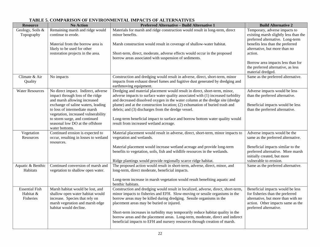
22
TABLE 5. COMPARISON OF ENVIRONMENTAL IMPACTS OF ALTERNATIVES Resource No Action Preferred Alternative – Build Alternative 1 Build Alternative 2
Geology, Soils & Topography
Remaining marsh and ridge would continue to erode. Material from the borrow area is likely to be used for other restoration projects in the area.
Materials for marsh and ridge construction would result in long-term, direct minor benefits. Marsh construction would result in coverage of shallow-water habitat. Short-term, direct, moderate, adverse effects would occur in the proposed borrow areas associated with suspension of sediments.
Temporary, adverse impacts to existing marsh slightly less than the preferred alternative. Long-term benefits less than the preferred alternative, but more than no action. Borrow area impacts less than for the preferred alternative, as less material dredged.
Climate & Air Quality
No impacts Construction and dredging would result in adverse, direct, short-term, minor impacts from exhaust diesel fumes and fugitive dust generated by dredging and earthmoving equipment.
Same as the preferred alternative.
Water Resources
No direct impact. Indirect, adverse impact through loss of the ridge and marsh allowing increased exchange of saline waters, leading to loss of intermediate marsh vegetation, increased vulnerability to storm surge, and continued seasonal low DO at the offshore water bottoms.
Dredging and material placement would result in direct, short-term, minor, adverse impacts to surface water quality associated with (1) increased turbidity and decreased dissolved oxygen in the water column at the dredge site (dredge plume) and at the construction location; (2) exhumation of buried trash and debris; and (3) discharges from the dredge vessel. Long-term beneficial impact to surface and borrow bottom water quality would result from increased wetland acreage.
Adverse impacts would be less than the preferred alternative. Beneficial impacts would be less than the preferred alternative.
Vegetation Resources
Continued erosion is expected to occur, resulting in losses to wetland resources.
Material placement would result in adverse, direct, short-term, minor impacts to vegetation and wetlands. Material placement would increase wetland acreage and provide long-term benefits to vegetation, soils, fish and wildlife resources in the wetlands. Ridge plantings would provide regionally scarce ridge habitat.
Adverse impacts would be the same as the preferred alternative. Beneficial impacts similar to the preferred alternative. More marsh initially created, but more vulnerable to erosion.
Aquatic & Benthic Habitats
Continued conversion of marsh and vegetation to shallow open water.
The proposed action would result in short-term, adverse, direct, minor, and long-term, direct moderate, beneficial impacts. Long-term increase in marsh vegetation would result benefiting aquatic and benthic habitats.
Same as the preferred alternative.
Essential Fish Habitat & Fisheries
Marsh habitat would be lost, and shallow open water habitat would increase. Species that rely on marsh vegetation and marsh edge habitat would decline.
Construction and dredging would result in localized, adverse, direct, short-term, minor impacts to fisheries and EFH. Slow-moving or sessile organisms in the borrow areas may be killed during dredging. Sessile organisms in the placement areas may be buried or injured. Short-term increases in turbidity may temporarily reduce habitat quality in the borrow areas and the placement areas. Long-term, moderate, direct and indirect beneficial impacts to EFH and nursery resources through creation of marsh.
Beneficial impacts would be less for fisheries than the preferred alternative, but more than with no action. Other impacts same as the preferred alternative.
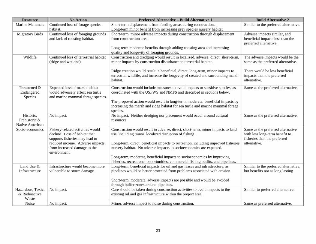
23
Resource No Action Preferred Alternative – Build Alternative 1 Build Alternative 2 Marine Mammals Continued loss of forage species
habitat. Short-term displacement from feeding areas during construction. Long-term minor benefit from increasing prey species nursery habitat.
Similar to the preferred alternative.
Migratory Birds Continued loss of foraging grounds and lack of roosting habitat.
Short-term, minor adverse impacts during construction through displacement from construction area. Long-term moderate benefits through adding roosting area and increasing quality and longevity of foraging grounds.
Adverse impacts similar, and beneficial impacts less than the preferred alternative.
Wildlife Continued loss of terrestrial habitat (ridge and wetland).
Construction and dredging would result in localized, adverse, direct, short-term, minor impacts by construction disturbance to terrestrial habitat. Ridge creation would result in beneficial, direct, long-term, minor impacts to terrestrial wildlife, and increase the longevity of created and surrounding marsh habitat.
The adverse impacts would be the same as the preferred alternative. There would be less beneficial impacts than the preferred alternative.
Threatened & Endangered
Species
Expected loss of marsh habitat would adversely affect sea turtle and marine mammal forage species.
Construction would include measures to avoid impacts to sensitive species, as coordinated with the USFWS and NMFS and described in sections below. The proposed action would result in long-term, moderate, beneficial impacts by increasing the marsh and ridge habitat for sea turtle and marine mammal forage species.
Same as the preferred alternative.
Historic, Prehistoric &
Native American
No impact. No impact. Neither dredging nor placement would occur around cultural resources.
Same as the preferred alternative.
Socio-economics Fishery-related activities would decline. Loss of habitat that supports fisheries may lead to reduced income. Adverse impacts from increased damage to the environment.
Construction would result in adverse, direct, short-term, minor impacts to land use, including minor, localized disruption of fishing. Long-term, direct, beneficial impacts to recreation, including improved fisheries nursery habitat. No adverse impacts to socioeconomics are expected. Long-term, moderate, beneficial impacts to socioeconomics by improving fisheries, recreational opportunities, commercial fishing outfits, and pipelines.
Same as the preferred alternative with less long-term benefit to fisheries than the preferred alternative.
Land Use & Infrastructure
Infrastructure would become more vulnerable to storm damage.
Long-term, beneficial impacts for oil and gas leases and infrastructure, as pipelines would be better protected from problems associated with erosion. Short-term, moderate, adverse impacts are possible and would be avoided through buffer zones around pipelines.
Similar to the preferred alternative, but benefits not as long lasting.
Hazardous, Toxic, & Radioactive
Waste
No impact. Care should be taken during construction activities to avoid impacts to the existing oil and gas infrastructure within the project area.
Similar to preferred alternative.
Noise No impact. Minor, adverse impact to noise during construction. Same as preferred alternative.
24
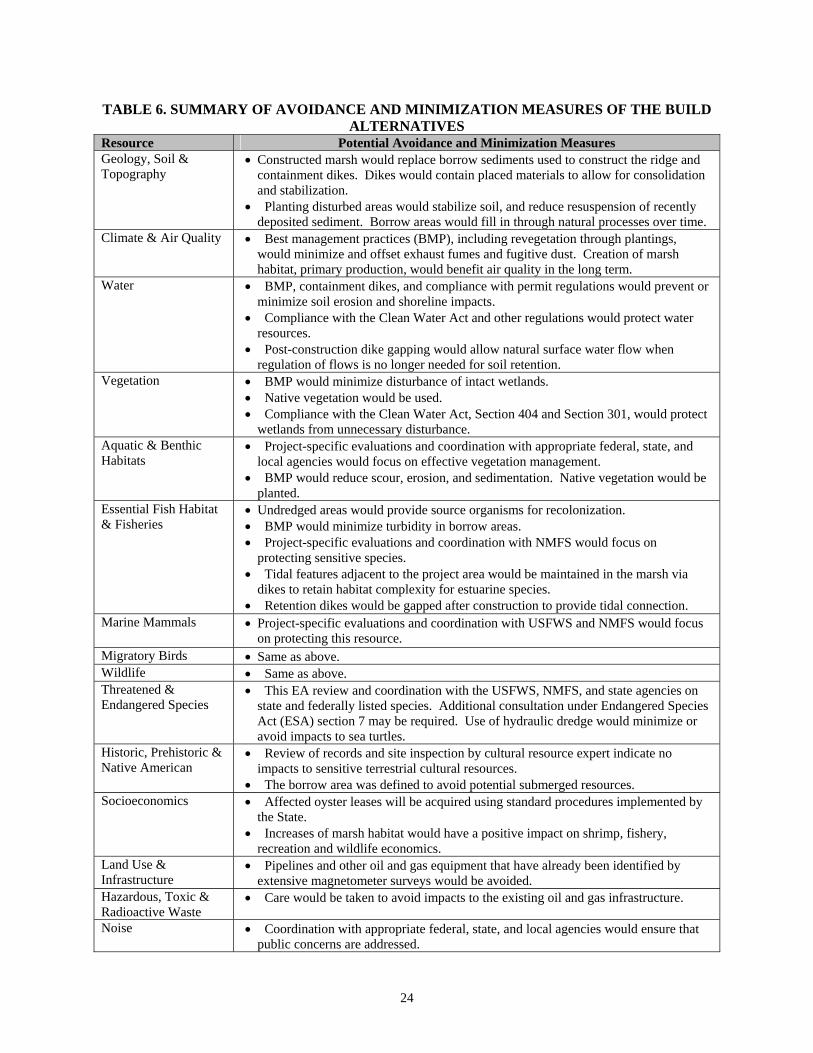
TABLE 6. SUMMARY OF AVOIDANCE AND MINIMIZATION MEASURES OF THE BUILD ALTERNATIVES
Resource Potential Avoidance and Minimization Measures Geology, Soil & Topography
Constructed marsh would replace borrow sediments used to construct the ridge and containment dikes. Dikes would contain placed materials to allow for consolidation and stabilization.
Planting disturbed areas would stabilize soil, and reduce resuspension of recently deposited sediment. Borrow areas would fill in through natural processes over time.
Climate & Air Quality Best management practices (BMP), including revegetation through plantings, would minimize and offset exhaust fumes and fugitive dust. Creation of marsh habitat, primary production, would benefit air quality in the long term.
Water BMP, containment dikes, and compliance with permit regulations would prevent or minimize soil erosion and shoreline impacts.
Compliance with the Clean Water Act and other regulations would protect water resources.
Post-construction dike gapping would allow natural surface water flow when regulation of flows is no longer needed for soil retention.
Vegetation BMP would minimize disturbance of intact wetlands. Native vegetation would be used. Compliance with the Clean Water Act, Section 404 and Section 301, would protect
wetlands from unnecessary disturbance. Aquatic & Benthic Habitats
Project-specific evaluations and coordination with appropriate federal, state, and local agencies would focus on effective vegetation management.
BMP would reduce scour, erosion, and sedimentation. Native vegetation would be planted.
Essential Fish Habitat & Fisheries
Undredged areas would provide source organisms for recolonization. BMP would minimize turbidity in borrow areas. Project-specific evaluations and coordination with NMFS would focus on
protecting sensitive species. Tidal features adjacent to the project area would be maintained in the marsh via
dikes to retain habitat complexity for estuarine species. Retention dikes would be gapped after construction to provide tidal connection.
Marine Mammals Project-specific evaluations and coordination with USFWS and NMFS would focus on protecting this resource.
Migratory Birds Same as above. Wildlife Same as above. Threatened & Endangered Species
This EA review and coordination with the USFWS, NMFS, and state agencies on state and federally listed species. Additional consultation under Endangered Species Act (ESA) section 7 may be required. Use of hydraulic dredge would minimize or avoid impacts to sea turtles.
Historic, Prehistoric & Native American
Review of records and site inspection by cultural resource expert indicate no impacts to sensitive terrestrial cultural resources.
The borrow area was defined to avoid potential submerged resources. Socioeconomics Affected oyster leases will be acquired using standard procedures implemented by
the State. Increases of marsh habitat would have a positive impact on shrimp, fishery,
recreation and wildlife economics. Land Use & Infrastructure
Pipelines and other oil and gas equipment that have already been identified by extensive magnetometer surveys would be avoided.
Hazardous, Toxic & Radioactive Waste
Care would be taken to avoid impacts to the existing oil and gas infrastructure.
Noise Coordination with appropriate federal, state, and local agencies would ensure that public concerns are addressed.
25
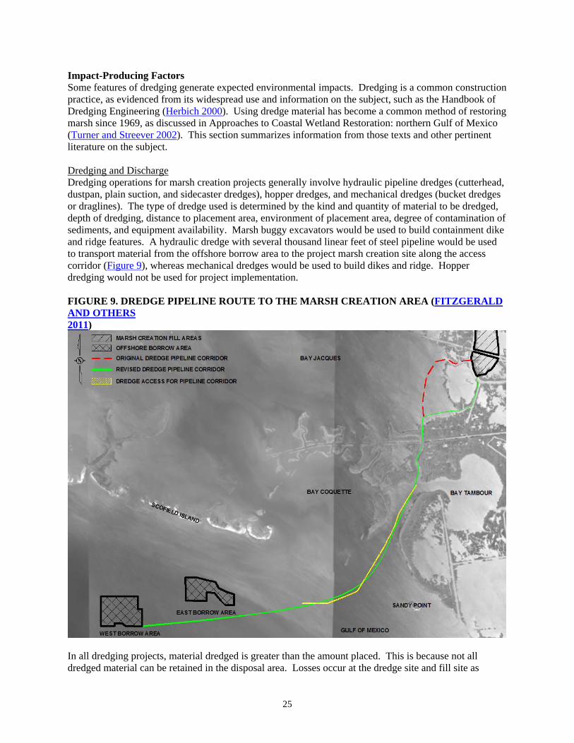
Impact-Producing Factors Some features of dredging generate expected environmental impacts. Dredging is a common construction practice, as evidenced from its widespread use and information on the subject, such as the Handbook of Dredging Engineering (Herbich 2000). Using dredge material has become a common method of restoring marsh since 1969, as discussed in Approaches to Coastal Wetland Restoration: northern Gulf of Mexico (Turner and Streever 2002). This section summarizes information from those texts and other pertinent literature on the subject. Dredging and Discharge Dredging operations for marsh creation projects generally involve hydraulic pipeline dredges (cutterhead, dustpan, plain suction, and sidecaster dredges), hopper dredges, and mechanical dredges (bucket dredges or draglines). The type of dredge used is determined by the kind and quantity of material to be dredged, depth of dredging, distance to placement area, environment of placement area, degree of contamination of sediments, and equipment availability. Marsh buggy excavators would be used to build containment dike and ridge features. A hydraulic dredge with several thousand linear feet of steel pipeline would be used to transport material from the offshore borrow area to the project marsh creation site along the access corridor (Figure 9), whereas mechanical dredges would be used to build dikes and ridge. Hopper dredging would not be used for project implementation. FIGURE 9. DREDGE PIPELINE ROUTE TO THE MARSH CREATION AREA (FITZGERALD AND OTHERS 2011)
In all dredging projects, material dredged is greater than the amount placed. This is because not all dredged material can be retained in the disposal area. Losses occur at the dredge site and fill site as
26
effluent discharge. The dikes and ridge of the preferred alternative would confine material until it settles and dewaters to best retain the dredged sediments and minimize discharge to the water column. Impacts to water quality are less for mechanical dredging than for hydraulic dredging because of the heavier sediment source and/or less mixing of the sediment for transport. Mechanically dredged material requires less de-watering, so less is lost from the disposal area to the surrounding water. Therefore, no additional measures to retain effluent during dike and ridge construction are necessary. Re-suspended materials that influence water quality are localized in the vicinity of the excavation tool and occur only during dredging. Materials then act as other suspended sediments in the coastal water, staying suspended or settling based on water movements due to tide, wind, or storm.
Physical Resources Impacts on Geology, Soils, and Topography No Action Under the no-action alternative, material from the borrow areas is likely to be used for other restoration projects in the area as sediment sources have long been recognized as a limited resource (Galliano and van Beek 1973). With no action, the shallow mud flats would wash away in storm conditions, with fine sediments being lost to the system and heavy sediments filling the nearby bayous. Without a ridge and marsh, water exchange from wind and tide flushes the area, moving sediments around. This is expected to continue until sediments are washed away and the shallow water then deepens. The Bayou Grand Liard ridge has eroded to marsh elevation or below. Adjacent marshes converted to shallow open water and are exposed mud flats at low tide. Geomorphology in the project area is characteristic of a highly eroding, sediment-deficient system with marsh areas increasing in salinity and converting to open water bays. Preferred Alternative - Build Alternative 1 Long-term, indirect, moderate benefits to this resource would result as ridge and marsh habitat are recreated. The created habitat would slow the flushing water exchange and allow establishment of vegetation on the ridge and marsh, clarify the remaining water and reduce the wind induced erosion caused by the current water exchanges. The proposed elevation increase would recreate upland and marsh habitat, similar to the habitats that once existed and increase organic material in the soils. Direct, minor adverse effects would result from the burial of current ridge and marsh habitat, because what remains of the ridge is now marsh and some marsh exists in the area. This impact is expected to be temporary, as long-term direct benefits of recreating more of this habitat is the project goal. Diking would temporarily reduce natural water exchange with the marsh. After placed sediment is consolidated, gaps may be placed in strategic places along the dike to return tidal influence to the marsh if natural consolidation and erosion of the dikes does not occur. The dredged material used for the ridge and dikes would consist of naturally occurring material to the area. Material dredged from offshore would be marine in origin; saline and silty. Vegetative plantings would be used to stabilize soil, reduce resuspension of recently deposited sediment, and encourage sedimentation. Short-term, direct, moderate, adverse effects would result in the direct suspension of sediments and disturbance to natural sediment sorting through and layering within the borrow areas. Water depth would increase in the bayou to a depth up to 12 ft in some places, but that depth exists in areas of the bayou currently, so the impact should be minor. Over the long term, dredged materials removed from the borrow area would be expected to rearrange by natural processes, and pre-dredging bathymetric contours would return to the dredged areas.
27
Build Alternative 2 The beneficial impacts are similar to the preferred alternative. Adverse impacts of placing dredged materials onto existing marsh habit would be the same as the preferred alternative. Because less borrow material would be needed, the minor, short-term, adverse impacts to the dredge area could be less than for the preferred alternative. Less long-term benefit to the marsh creation area is expected, as the elevations would erode faster than in the preferred alternative. Impacts on Climate and Air Quality Neither the no-action alternative nor any of the build alternatives would substantially affect the climate or weather. However, there is some suggestion that increases in marsh acreage can contribute to the overall carbon sink and mitigate the effects of atmospheric carbon on global warming, which may indirectly reduce the intensity of hurricanes in the Gulf of Mexico. No Action The no-action alternative would not result in any changes to existing air quality in the area. Build Alternatives Short-term, direct, minor, adverse impacts to air quality from construction would be associated with emissions from diesel engines that would power the dredging machinery, and material placement operations. Emissions would occur over a period of a few months, with most emissions occurring at the dredge and ridge creation sites. The emissions would consist predominantly of nitrogen oxides, with smaller amounts of carbon monoxide, sulfur dioxide, particulate matter, and volatile organic compounds. Prevailing winds would dissipate airborne pollutants and limit them to the proposed project’s construction phase. In addition, newly placed, unconsolidated dredged material is subject to drying and blowing during high wind events, adding particulates to the air. Revegetation would hold sediments in place after a time. The impact to human health would be negligible because the proposed project area is remote from any residential area. In the long term, air quality in the area is expected to be unchanged. Impacts on Water Resources No Action The no-action alternative would not directly affect local water quality. Long-term, indirect, moderate, adverse impacts would result from increased water exchange and turbidity of the water while more land erodes. The area would remain and increase in vulnerability to storm surge. Preferred Alternative - Build Alternative 1 Short-term, minor, direct, adverse impacts associated with dredging required for implementation of the preferred alternative would include: (1) increased turbidity and decreased dissolved oxygen in the water column at the dredge sites (dredge plume) and fill sites; (2) potential decreased dissolved oxygen in the water column at the construction location due to increased water depth (>5 meters); (3) possible exhumation of buried debris; and (4) discharges from the dredge vessel. During dredging, silt or clay may become suspended in the water column near the dredge site. The suspended sediment would settle in a matter of hours to days (depending on current). If the disturbed sediments were anoxic, the dissolved oxygen levels in the water column would decrease. Turbidity and suspended particulate levels in the water column above the preferred borrow area are normally high as a result of coastal processes. Long-term, minor, indirect benefits to water quality would result from the ability of created marsh to remove nitrates and phosphate and reduce turbidity in the water (EPA 2008). To date, no issues related to decreased dissolved oxygen have emerged from previous coastal restoration projects of this type. Build Alternative 2 Short-term, direct, minor adverse impacts to water quality would be slightly less than the preferred and more than the no action as less dredging would be necessary. The duration of adverse impacts is dependent on the duration of construction. The preferred alternative is expected to have a slightly longer construction duration than this build alternative.
28
Long-term, indirect, minor benefits would be less than the preferred and more than no action alternative. With this alternative, the elevation of the marsh would not remain productive for as many years or prevent as much turbidity in the water over time as with the preferred alternative.
Biological Environment Impacts on Vegetation Resources No Action With no action, continued erosion and subsidence are expected to occur, resulting in losses to vegetative resources. Preferred Alternative - Build Alternative 1 The preferred alternative would exert direct, minor, long-term beneficial impacts on vegetative communities of the area (NMFS 2008, 2011). Adding elevation to marshes would help offset local subsidence, increase vegetative productivity and decrease marsh conversion to open water. Increasing the elevation in the area would be beneficial to vegetative communities, reducing flooding stress on the plants and allow time for vegetation to colonize and contribute to the elevation. Accumulation of organic material is a primary factor influencing the vertical accretion of marshes. Creation of the ridge would allow for shrub species to colonize and stabilize the ridge sediments allowing a greater diversity of vegetation to be supported in the project area. Creation of the ridge would also protect marsh vegetation from excessive water exchanges that stress the plants and erode their soils. Implementing the preferred alternative would unavoidably have direct, minor, short-term adverse impacts to existing marsh, and shallow open water areas and their associated vegetative communities. Long-term, direct, moderate benefits to these habitats are expected through increased marsh habitat, clarification of water, increased marsh edge, creation of regionally scarce ridge habitat, increased submerged aquatics and other habitats that are important to fish and wildlife species. Build Alternative 2 This alternative would have long-term, direct, minor, beneficial impacts on vegetative communities by adding elevation and increasing marsh vegetation, similar but less lasting than the preferred alternative. While more marsh area would initially be created with this alternative, the marsh would be more susceptible to erosion due to settlement and lower initial elevations compared to the preferred alternative (Fitzgerald and others 2011). Adverse impacts would be the same as the preferred alternative. Impacts on Aquatic and Benthic Habitats No Action Submerged vegetation and emergent habitats are much less common and more vulnerable to disturbance than open water habitats. The quality of aquatic and benthic habitat is expected to decrease as marsh and beach habitats are converted to open water. In the borrow area, a continuation of seasonal low DO along bottom waters is expected for the foreseeable future, as the area of low DO has been increasing the last 60 years and reduction of nitrogen and phosphorous from the Mississippi River are planned (EPA 2008), but effects of reduction are unknown. Build Alternatives Under the preferred alternative, short-term, local, direct, minor adverse impacts to aquatic and benthic resources would occur by the direct removal of sediment along with the organisms living in the sediment during dredging. Other direct, adverse impacts could include entrapment and likely death of slow-moving organisms and polycheates during dredging, and smothering of benthic organisms in the deposition sites. Mobile invertebrates would be expected to vacate the proposed project area during construction and return after construction is complete. Invertebrates, oysters, and fish that do not move out of the area would likely be injured by suffocation from suspended sediments. Dredging would change substrate topography, causing a temporary redistribution of organisms in the immediate vicinity.
29
Benthic organisms would likely re-colonize borrow areas. Early-stage recruitment of defaunated sediments occurs rapidly in coastal systems (Grassle and Grassle 1974, McCall, 1977, Simon and Dauer 1977, Ruth and others 1994, all as cited in EPA 2003). Dredged sites would be rapidly colonized by opportunistic infauna (EPA 2003). Later stages of colonization would be more gradual and would depend on environmental conditions after cessation of dredging. Fish and invertebrates are expected to recover as turbidity returns to pre-construction levels. There is expected to be a low potential for creation of persistent low DO conditions that would impact fisheries and aquatic biota in the borrow and placement areas given the patterns of water flow over the borrow sites and the shallow elevation of placement area. Long-term, minor, indirect benefits would result from the increase in quality aquatic and benthic habitat from increased primary productivity. The created marsh would contribute to detritus and decrease turbidity with the built alternatives. Fisheries access to marsh would be maintained having retaining dikes along existing waterways and ensuring tidal exchange after construction. Impacts on Essential Fish Habitat No Action The variety and quality of EFH associated with estuarine areas are expected to continue to decrease as the remaining marsh converts to open-water. Only open-water EFH, which is not in short supply, would increase. Build Alternatives The effects are similar for both build alternatives. Long-term, moderate, direct and indirect benefits of the build alternatives would result from re-establishing marsh, improving estuarine-related EFH. Marsh and marsh edge habitat would increase with vegetative and hydrological features that develop post-construction aided by gapping of the dikes and vegetative plantings. Detrital material, formed by the breakdown of emergent vegetation, would contribute to the aquatic food web of the surrounding ecosystem. Decreases in tidal and storm erosion would protect estuarine mud bottoms and marsh ponds around the proposed project area. Thus, the preferred alternative would restore more productive habitats supportive of brown shrimp, white shrimp, and red drum. Short-term, unavoidable, direct and indirect, adverse impacts to habitats supportive of various life stages of brown shrimp, white shrimp, and red drum would occur during the construction phase of the proposed project as marsh is filled and created. Potential short-term impacts to EFH include movement of prey species away from the construction area, interruption of feeding or spawning by some species, and other effects on behavioral patterns. No significant adverse impacts on EFH are expected, because hundreds of acres of similar substrate are available to organisms outside of the areas to be dredged. Post-construction long-term benefits of increased quality and quantity of the marsh would be greater than the short-term adverse impacts. Turbidity would return to ambient conditions post-construction. Impacts on Fishery Resources No Action Abundant open water fisheries habitat is available in coastal Louisiana and increasing. The increase in open water fisheries habitat comes at the expense of submerged vegetation and emergent fisheries habitats, which are less common and more vulnerable to disturbance than open water habitat. The quality of fish habitat is expected to decrease as remaining marsh converts to open water reducing the nursery function of the area for estuarine-dependent species. Preferred Alternative - Build Alternative 1 Short-term, local, minor, direct adverse impacts to fishery resources would occur during construction from dredging and placement of sediments. Dredging would directly move benthic organisms that live in the sediment and indirectly entrap the slow-moving organisms and polycheates of the borrow areas. In the placement area, smothering of benthic organisms and sessile fish and invertebrate species would occur. Mobile aquatic animals would move during construction and return after construction completes. Short-term minor adverse effects on fish eggs and
30
larvae in the immediate area may occur. These are short-term, adverse impacts because benthic organisms would likely recolonize borrow areas. Early-stage recruitment of defaunated sediments occurs rapidly in coastal systems (Grassle and Grassle 1974, McCall, 1977, Simon and Dauer 1977, Ruth and others 1994, all as cited in EPA 2003). Dredged sites would be rapidly colonized by opportunistic infauna (EPA 2003). Later stages of colonization would be more gradual and would depend on environmental conditions after cessation of dredging. Fish and invertebrates are expected to recover as turbidity returns to pre-construction levels. Long-term, moderate, direct and indirect beneficial impacts would result from created marsh habitat providing nursery for estuarine-dependent fisheries that does not currently exist and would not exist with the no-action alternative. Access to the marsh habitat would be maintained after construction through the retained waterways and dike gapping. Build Alternative 2 Impacts to fisheries and aquatics are not expected to differ substantially from those described for the preferred alternative. The decreased longevity (due to elevation and erosion) and diversity of vegetation (ridge and marsh) compared to the preferred alternative could have less indirect benefit to fisheries and aquatics. As a result, estuarine-dependent fisheries would have less long-term beneficial impacts than with the preferred alternative, but more benefits than with no action. Impacts on Marine Mammal Resources No Action With no action, the marsh used by marine mammal forage species, such as small fish, would decline, and no ridge habitat would be constructed for roosting birds. Build Alternatives The effects are similar for both build alternatives. Whales are unlikely to occur (NMFS 2010). Manatees are rare for this area, so are unlikely to occur, but dolphin are common along the coast of the project area. Dolphins are likely to avoid project areas during construction. They would be temporarily displaced, as would their fish food source. The dolphins would follow the fish populations for feeding and both prey and predator would return shortly after construction. Therefore, the build alternatives have short-term, indirect, minor, adverse impacts. In the long-term, moderate, direct and indirect benefits would result from increasing the quantity and longevity of prey nursery grounds, and refuges. Contractors would be instructed to watch for marine mammals. Should any manatee or dolphin be seen, any workboats in the area would be instructed to cease work until any creature is over 500 ft away. Impacts on Migratory Bird Resources No Action With no action, the marsh used by migratory birds and their forage species would decline, and no ridge habitat would be constructed for roosting birds. Preferred Alternative - Build Alternative 1 No migratory birds are known to nest in the area. Foragers would be temporarily displaced to the abundance of nearby foraging habitat and benefit after construction by the new habitat diversity, and longevity of the foraging marsh and roosting ridge habitats. No substantial adverse impacts would occur. Because it is uncertain whether nesting colonies occur within the project area vicinity, the project site may be inspected by a qualified biologist to determine if undocumented nesting water birds are present during the nesting season. If colonies containing nesting wading birds (i.e., herons, egrets, night-herons, ibis, and roseate spoonbills), anhingas, and/or cormorants are observed, all activities within 1,000 ft of the nesting colony should be restricted to the non-nesting period (i.e., September 1 through February 15, exact dates may vary within this window depending on species present). Because the anticipated construction duration is in excess of eight months and some construction activities may occur during the nesting season, time-of-year restrictions may not be practicable. Accordingly, an abatement plan to
31
ensure that birds do no nest at the time of project construction will be developed in consultation with the USFWS if required to address potential nesting. The USFWS would be contacted to report the colonies location and consult on the species present and their non-nesting periods. If nesting were to occur it would be prior to construction, as the disturbance of construction would prevent colonies from selecting the area for nesting during construction. Long-term, direct and indirect, moderate benefits would occur by creating nesting areas for colonial waterbirds once vegetation becomes established, and increasing the quantity and quality of foraging area. Build Alternative 2 Adverse impacts and avoidance measures would be the same as with the preferred alternative. There would be no roosting area created with this option and the longevity of the increased foraging area would be less than with the preferred alternative, but more than the no action alternative. Impacts on Wildlife Resources No Action With no action, the remaining marsh and mud flat would convert to open water. Habitat would become less suitable for waterfowl, small mammals, and increase for aquatic species that are not habitat limited, such as alligator. Current waterfowl declines would continue (LCWCRTF and WCRA 1999). Preferred Alternative - Build Alternative 1 Short-term, direct, minor, localized adverse impacts to wildlife would result from displacement. Wildlife would vacate or avoid the area and return once construction is complete. Proposed project modifications to avoid impacts to wildlife were coordinated with USFWS (2011). Long-term, direct, moderate benefits would result from increasing wildlife habitat through marsh and ridge creation. Creation of the ridge would provide habitat for birds, furbearer and game mammal populations that does not exist and would not exist with no action. Many bird species are migratory or permanent residents and depend on marsh of the proposed project area. Population numbers of bird species are expected to increase in response to implementation of the preferred alternative. Build Alternative 2 The temporary adverse impacts from disturbance of wildlife during construction would be similar to the preferred alternative. Long-term benefits of increased diversity of habitat and upland ridge creation would be less than for the preferred alternative but more than the no action alternative. Created marsh would not be expected to last as long and the diversity of habitat would be less with this action than with the preferred alternative, but more than the no action alternative. Impacts on Threatened and Endangered Species No Action Without action existing marsh that is habitat for the sea turtle and marine mammal forage species, such as shrimp and fish species, would continue to be lost. Build Alternatives The effects are similar for both build alternatives. In a biological opinion prepared by NMFS for a similar project (NMFS 2010), the leatherback sea turtle, hawksbill sea turtle, Gulf sturgeon, smalltooth sawfish, and endangered whales were listed as “not likely to be adversely affected”, because they do not commonly occur in the project area (NMFS 2010). Whales were “extremely unlikely to overlap geographically with the action area,” and similar findings were listed for leatherback sea turtle, hawksbill sea turtle, Gulf sturgeon, and smalltooth sawfish (NMFS 2010). Due to the similarity in the project location and type of the biological opinion (NMFS 2010), we do not expect these species to be adversely affected from this project and do not discuss them further. Placement of dredged material is unlikely to adversely affect threatened and endangered species (NMFS 2010).
32
Manatees may rarely occur in coastal Louisiana during the warmer months and area unlikely to occur in the project area. Additionally, methods used to minimize impacts to sea turtles and Gulf sturgeon would also reduce the potential to affect manatees. Both USFWS and NMFS have concurred that the proposed project is not likely to adversely affect federally-listed threatened or endangered species or associated critical habitat. Long-term, moderate, indirect benefits to listed species may result from increasing the quality of forage species habitat and quantity of refuge area.
Cultural Resources Impacts on Historic, Prehistoric, and Native American Resources No Action There are no known terrestrial cultural resources located in the project area. The identified potential submerged cultural resources in the borrow area would not be affected. Build Alternatives Potential submerged cultural resources located in the borrow areas would be avoided with a 300-ft buffer zone and therefore unaffected by build alternatives. No other resources have been identified in the area. The Louisiana State Historic Preservation Office has concurred that no archeological or historic resources would be adversely impacted by the proposed project and that potential submerged cultural resources in the borrow area would be avoided with a 300-ft buffer zone. Impacts on Socioeconomics No Action As the remaining marsh is lost to open water and mud flats deepen, the benefit of the area as shrimp habitat declines. Loss of shrimp leads to loss of income in the region because marsh habitats provide essential nursery function to shrimp. Fisheries related activities would decline. Preferred Alternative - Build Alternative 1 This alternative would have a short-term, minor, direct adverse impact through disruption of localized fishing during construction. Direct, short-term, moderate benefits through local job creation would result from construction activities. Long-term, indirect, moderate benefits would result from increasing shrimp habitat, and recreational and fishing value of the area. Affected oyster leases will be acquired using standard procedures implemented by the State, and therefore have no significant impact. Build Alternative 2 All impacts would be similar to the preferred alternative with the exception that long-term benefits to fisheries would be less than the preferred alternative and more than the no action alternative. The marsh habitat in the area that supports shrimp, a major component of the commercial and recreational fishing economy, would not last as long as it would with a ridge feature. Impacts on Land Use and Infrastructure No Action Conversion of the proposed project area to open water increases exposure of both active and inactive pipelines posing threats to human safety, and decreases the commercial and recreational value of the area. Increased storm surges would erode nearby land and increase structural damages from storms. Preferred Alternative - Build Alternative 1 Long-term, direct and indirect, minor benefits would result from the ridge acting as a land buffer during storms. Storm-associated vulnerabilities would decrease for surrounding land, pipelines and infrastructure. Short-term, moderate, reversible, adverse impacts on recreational fishing would occur during construction. However, habitat suitable for fishing is common in the region, and the temporary loss of opportunity for fishing in the proposed project area is considered minimal. Construction would avoid pipelines and maintain waterways of the area used by local boat navigators.
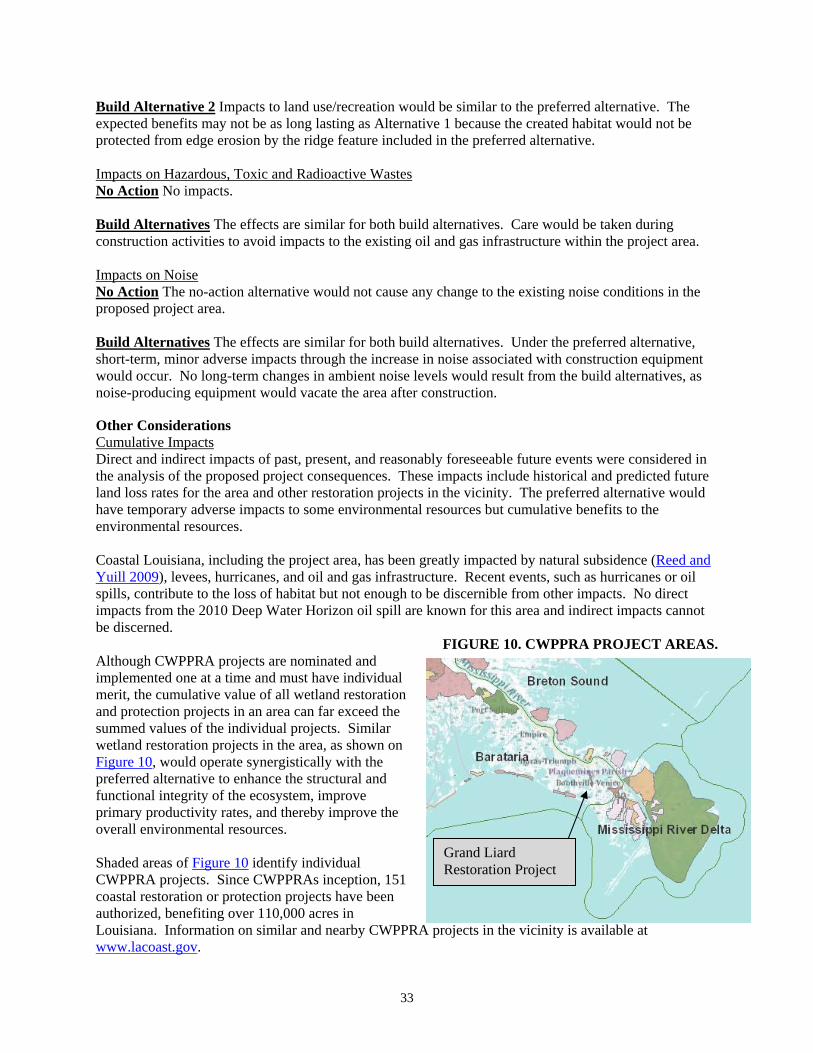
33
Build Alternative 2 Impacts to land use/recreation would be similar to the preferred alternative. The expected benefits may not be as long lasting as Alternative 1 because the created habitat would not be protected from edge erosion by the ridge feature included in the preferred alternative. Impacts on Hazardous, Toxic and Radioactive Wastes No Action No impacts. Build Alternatives The effects are similar for both build alternatives. Care would be taken during construction activities to avoid impacts to the existing oil and gas infrastructure within the project area. Impacts on Noise No Action The no-action alternative would not cause any change to the existing noise conditions in the proposed project area. Build Alternatives The effects are similar for both build alternatives. Under the preferred alternative, short-term, minor adverse impacts through the increase in noise associated with construction equipment would occur. No long-term changes in ambient noise levels would result from the build alternatives, as noise-producing equipment would vacate the area after construction.
Other Considerations Cumulative Impacts Direct and indirect impacts of past, present, and reasonably foreseeable future events were considered in the analysis of the proposed project consequences. These impacts include historical and predicted future land loss rates for the area and other restoration projects in the vicinity. The preferred alternative would have temporary adverse impacts to some environmental resources but cumulative benefits to the environmental resources. Coastal Louisiana, including the project area, has been greatly impacted by natural subsidence (Reed and Yuill 2009), levees, hurricanes, and oil and gas infrastructure. Recent events, such as hurricanes or oil spills, contribute to the loss of habitat but not enough to be discernible from other impacts. No direct impacts from the 2010 Deep Water Horizon oil spill are known for this area and indirect impacts cannot be discerned.
FIGURE 10. CWPPRA PROJECT AREAS. Although CWPPRA projects are nominated and implemented one at a time and must have individual merit, the cumulative value of all wetland restoration and protection projects in an area can far exceed the summed values of the individual projects. Similar wetland restoration projects in the area, as shown on Figure 10, would operate synergistically with the preferred alternative to enhance the structural and functional integrity of the ecosystem, improve primary productivity rates, and thereby improve the overall environmental resources. Shaded areas of Figure 10 identify individual CWPPRA projects. Since CWPPRAs inception, 151 coastal restoration or protection projects have been authorized, benefiting over 110,000 acres in Louisiana. Information on similar and nearby CWPPRA projects in the vicinity is available at www.lacoast.gov.
Grand Liard Restoration Project
34
Physical cumulative impacts of this and other restoration projects are to slow the land loss rate in coastal Louisiana. Currently, land loss is at an average rate of an acre every 38 minutes. If the current rate of loss is not slowed by the year 2040, an additional 800,000 acres of wetlands will convert to open water. Physical cumulative impacts are related to mining borrow sediments. The effect of borrowing from multiple offshore sources has been evaluated previously (USACE 2004) and determined to have short-term minor to moderate cumulative adverse impacts to benthic sand resources from dredging and construction activities. For this project, a wave analysis (Forrest-Vandera and others 2010) concluded that wave energies would not be substantial affected by using borrow area sediments. Given previous offshore sand resource investigations (e. g. USACE 2004, EPA 2003), the cumulative impacts are not expected to differ from the direct and indirect project effects. No significant adverse cumulative impact is expected to result from the proposed action. The cumulative impact of the proposed action on air and water quality would not differ substantially from the effects of the alternatives considered individually, as similar impact producing events would not co-occur in space or time. The cumulative beneficial impact to water quality would be a long-term increase in quality as a result of reduced turbidity, decrease nitrogen and phosphorus, thereby reducing the frequency of low DO events. Biological cumulative impacts would be similar to the direct and indirect impacts of the alternatives described previously. All build alternatives would work with existing projects to enhance habitat for fish, wildlife, vegetation, and EFH. Cumulatively, all build alternatives would increase benefits to the area by decreasing land loss rates. No cumulative adverse impacts are anticipated. Socio-economic cumulative impacts would result from synergy of the build alternatives with nearby restoration projects. These projects would cumulatively decrease losses of habitat, thereby maintaining more of the economy and storm protection than with no action. The build alternatives are similar to previous actions in the area that have had no adverse cultural impacts. No adverse cumulative impacts would be expected. Invasive Species Executive Order 13112 requires federal agencies to use authorities to prevent introduction and control (in cost effective and environmentally sound manners) invasive species, and to provide for restoration of native species and habitats in ecosystems that have been invaded. As stated above, the purpose of the preferred alternative is to restore the native habitat. The proposed project would not introduce invasive species. If woody invasive species colonize the project area, an eradication plan is being developed and funds for its execution are envisioned as part of the project’s 20-year maintenance. Coordination Coordination in development of the proposed action, its alternatives and selection of the preferred alternative has been maintained with each CWPPRA Task Force agency. The project was vetted publicly through the CWPPRA process, which includes opportunities for the public and CWPPRA agencies to comment on the proposed project. The project was discussed in public meetings for CWPPRA where project details were made available on several occasions. A draft EA was circulated to participating restoration agencies and the public. Comments received are provided in Appendix A. The preferred alternative is not expected to cause adverse environmental impacts that would require compensatory mitigation.
35
Compliance with Laws and Regulations This section presents a review of the potentially applicable laws and regulations that govern this proposed restoration project. Many federal, state, and local laws and regulations are considered during development of the proposed restoration project, as well as several regulatory requirements that are typically evaluated during the permitting process. A brief review of potentially applicable laws and regulations that may pertain to this proposed project is presented below. The project manager would ensure that there is coordination among these programs where possible and that project implementation and monitoring are in compliance with all applicable laws and regulations. National Environmental Policy Act of 1969 NEPA was enacted in 1969 to establish a national policy for the protection of the environment. The CEQ was established to advise the President and to carry out certain other responsibilities relating to implementation of NEPA by federal agencies. Pursuant to Presidential Executive Order, federal agencies are obligated to comply with NEPA regulations adopted by the CEQ (40 CFR Parts 1500-1508). These regulations outline the responsibilities of federal agencies under NEPA and provide specific procedures for preparing environmental documentation to comply with NEPA. Clean Water Act (CWA) The CWA is the principal law governing pollution control and water quality of the nation’s waterways. It requires the establishment of guidelines and standards to control the direct or indirect discharge of pollutants to waters of the United States. Discharges of material into navigable waters are regulated under Sections 401 and 404 of the CWA. The USACE has the primary responsibility for administering the Section 404 permit program. Under Section 401 of the CWA, projects that involve discharge or fill to wetlands or navigable waters must obtain certification of compliance with state water quality standards. Compliance with applicable sections of the CWA will be achieved through application for Section 404 authorization from the USACE and Water Quality Certification from the LDEQ. Clean Air Act of 1970 Under the Clean Air Act of 1970, Congress established procedures for developing National Ambient Air Quality Standards (NAAQS) for the protection of human health and public welfare. EPA published the NAAQS in 1971, and they became effective at that time. Standards are provided for the following criteria pollutants: carbon monoxide, sulfur dioxide, nitric oxide, ozone, lead, and fine particulate matter. Compliance with applicable provisions of the Clean Air Act will be achieved through requirements incorporated into construction contracts. Coastal Zone Management Act The Coastal Zone Management Act (CZMA) provides for protection of resources found in the coastal zone, proactive land management practices, and preservation of unique coastal resources. Included in the CZMA is the requirement that all federal actions within the coastal zone of Louisiana must be consistent with the federally approved State of Louisiana Coastal Resource Management Plan. Compliance with the CZMA has been achieved through review by the Louisiana Department of Natural Resources under its Federal Consistency program. Federal consistency was issued December 2011. Executive Order 11998, Floodplain Management Executive Order 11998, Floodplain Management, requires each agency (including military departments) to determine whether any action undertaken would occur in a floodplain. The Federal Emergency Management Agency provides Flood Insurance Rate Maps (FIRM) for more than 19,000 communities in the country as part of the Flood Insurance Studies the agency completes. In addition to the 100-year floodplain, which is the area of the community with a 1 percent chance of flooding in any given year, the FIRM also illustrates coastal high hazard areas, the floodway, and the 500-year floodplain, which is the area of the community with a 0.2 percent chance of flooding in any given year. EO 11998, including public review and engagement of landowners, has been
36
considered through the project development process. The purpose of this project is to maintain existing hydrological functions, thus not resulting in any increased flooding risk. Executive Order 11990, Protection of Wetlands The intent of Executive Order 11990, Protection of Wetlands, is to avoid, to the extent possible, the long- and short-term adverse impacts associated with the destruction or modification of wetlands and to avoid direct or indirect support for new construction in wetlands whenever there is a practicable alternative. Executive Order 12898, Federal Actions to Address Environmental Justice in Minority Populations and Low-Income Populations Executive Order 12898, Federal Actions to Address Environmental Justice in Minority Populations and Low-Income Populations, directs that the programs of federal agencies identify and address disproportionately high and adverse effects on human health and the environment of minority or low-income populations. No adverse effects on human health or the environment of minority or low-income populations are anticipated to result from the proposed project. Indirect, temporary benefits may result associated with construction and support related employment opportunities. The Endangered Species Act of 1973 (ESA) The ESA directs all federal agencies to conserve endangered and threatened species and their habitats and encourages such agencies to utilize their authorities to further these purposes. Under the Act, NMFS and USFWS publish lists of endangered and threatened species. Section 7 of the act requires that federal agencies consult with these agencies to minimize the effects of federal actions on endangered and threatened species. NOAA has, through both the NEPA and CWA Section 404 interagency review processes, coordinated with both USFWS and NOAA regarding endangered species. As proposed, the project includes mitigations to avoid and minimize potential impacts to endangered species and their critical habitats that are specified in the project permit. Both USFWS and NMFS have concurred with the determination that the proposed action is not likely to adversely affect federally-listed species or associated critical habitat. Migratory Bird Treaty Act of 1918 (MBTA) The MBTA requires the protection of all migratory bird species and protection of ecosystems of special importance to migratory birds against detrimental alteration, pollution, and other environmental degradation. Coordination under MBTA is generally incorporated into Section 404 of the CWA, NEPA, or other federal permit, license or review requirements. As proposed, the project includes plans to abate potential impacts to migratory birds through use of active patrols during nesting season, use of deterrents such as human presence during construction, and potential use of hazing techniques (boomers) if determined to be necessary during construction. Fish and Wildlife Coordination Act The Fish and Wildlife Coordination Act requires agencies to consult with the USFWS, NMFS, and appropriate state agencies, prior to modification of any stream or other body of water, to ensure conservation of wildlife resources. Compliance with the FWCA is integrated into the USACE interagency review process under Section 404 of the CWA as well as through the NEPA review process. Archeological and Historic Preservation Act of 1974 The Archeological and Historic Preservation Act of 1974 states that, if an activity may cause irreparable loss or destruction of significant scientific, prehistoric, historic, or archeological data, the responsible agency is authorized to undertake data recovery and preservation activities, in accordance with implementing procedures promulgated by the Secretary of the Interior. The Louisiana State Historic Preservation Office has concurred that no archeological or historic resources would be adversely impacted by the proposed project.
37
National Historic Preservation Act of 1966 The National Historic Preservation Act of 1966, as amended in 1992, requires that responsible agencies taking action that affects any property with historic, architectural, archeological, or cultural value that is listed on or eligible for listing on the National Register of Historic Places (NRHP) comply with the procedures for consultation and comment issued by the Advisory Council on Historic Preservation. The responsible agency also must identify properties affected by the action that are potentially eligible for listing on the NRHP, usually through consultation with the state historic preservation officer. The Louisiana State Historic Preservation Office has concurred that no archeological or historic resources would be adversely impacted by the proposed project. Magnuson-Stevens Fishery Conservation and Management Act (Magnuson-Stevens Act) In 1996, the act was reauthorized and changed by amendments to require that fisheries be managed at maximum sustainable levels and that new approaches be taken in habitat conservation. EFH is defined broadly to include “those waters and substrate necessary to fish for spawning, breeding, feeding or growth to maturity” (62 Fed. Reg. 66551, § 600.10 Definitions). The act requires consultation for all federal agency actions that may adversely affect EFH. Under Section 305(b)(4) of the act, NMFS is required to provide advisory EFH conservation and enhancement recommendations to federal and state agencies for actions that adversely affect EFH. Where federal agency actions are subject to ESA Section 7 consultations, such consultations may be combined to accommodate the substantive requirements of both ESA and the Magnuson-Stevens Act. EFH consultation has been completed through both CWA Section 404 procedures as well as NEPA processes.
CONCLUSIONS
The natural processes of subsidence, habitat switching, and erosion of wetlands have been exacerbated by widespread human alterations of sediment delivery and other processes, resulting in marked degradation of the Louisiana coastal area. Without intervention to retard or reverse the loss of marshes, ridges and barrier islands Louisiana’s healthy and highly productive coastal ecosystem would not be maintained. This EA discloses information on the direct, indirect and cumulative impacts on the human environment likely to result from the Grand Liard Marsh and Ridge Restoration Project. It has disclosed long-term beneficial impacts on the coastal resources of south Louisiana and does not anticipate any substantial long-term adverse environmental impacts. Construction-related adverse impacts are considered minor as they are temporary or reversible. This EA predicts beneficial impacts that would be moderate. This effects analysis is based on a review of relevant literature, site-specific data, and project-specific engineering reports related to biological, physical, and cultural resources, as well as on the cumulative experience gained through many similar coastal restoration projects in south Louisiana over the past decade. The increase of fisheries habitat is anticipated to have long-term beneficial impacts on the local economy and culture as it relates to recreational and commercial fishing. In addition, the preferred alternative would result in increased protection of adjacent marsh in the area to be restored. NMFS will review, evaluate and consider the information in this EA to determine whether to issue a Finding of No Significant Impact (FONSI) for the proposed action.
PREPARERS
This EA was prepared by biologists Joy Merino, Rachel Sweeney, Cecelia Linder, John Foret, Ph.D. and Phillip Parker, P.E. of NMFS, in consultation with USFWS, Louisiana SHPO, and the CWPPRA Technical Committee. Correspondence is provided in Appendix A.
38
DISTRIBUTION LIST
This EA was distributed for comment to agencies of the CWPPRA Task Force and resource agencies as listed below. A 30-day comment period was provided. A draft EA was available for public review. A final EA will be made available to the public at www.lacoast.gov along with other public records for the project. The EA was distributed to: Thomas A. Holden Chairman Deputy District Engineer, U.S. Army Engineer District, New Orleans
Office of the Chief. 7400 Leake Ave. New Orleans, Louisiana 70160-0267 Kirk Rhinehart Acting Asst. Secretary, Office of Coastal Protection and Restoration. 617 North 3rd
Street Baton Rouge, Louisiana 70804-4027 Richard Hartman Fishery Biologist, National Marine Fisheries Service. Rm 266 Military Science Bldg
South Stadium Drive, LSU Baton Rouge, Louisiana 70803-7535 Karen McCormick Environmental Protection Agency, Region 6 Water Quality Protection Division
(6WQ-EM). 1445 Ross Avenue Dallas, Texas 75202-2733 Britt Paul, P.E. Assistant State Conservationist, Water Resources, Natural Resources Conservation
Service. 3737 Government Street Alexandria, Louisiana 71302 Charles McGimsey State Historic Preservation Office.1051 North 3rd Street Rm 405 Baton Rouge LA
70802 Brad S. Rieck Acting Field Supervisor, U.S. Fish and Wildlife Service. 646 Cajundome Blvd., Suite 400
Lafayette, Louisiana 70506
LITERATURE CITED
Arcadis, Inc. 2011. Negative Findings Report of the Reconnaissance Archaeological Survey for the Bayou Grand Liard Marsh and Ridge Restoration Project (BA-68). March. 19 pp plus Appendices.
Boesch, DF, MN Josselyn, AJ Mehta, JT Morris, WK Nuttle, CA Simenstad and DJP Swift. 1994. Scientific Assessment of Coastal Wetland Loss, Restoration and Management in Louisiana. Journal of Coastal Research. Specific Issue No. 20. 103 pp.
Conner, WH and JW Day, Jr. (editors). 1987. The Ecology of Barataria Basin, Louisiana: An Estuarine Profile. U.S. Fish and Wildlife Service. Biological Report 85(7.13). July. 166 pp.
Council on Environmental Quality (CEQ). 1992. Regulations for Implementing the Procedural Provisions of the National Environmental Policy Act, Reprint, 40 CFR Parts 1500-1508, Executive Office of the President, Council on Environmental Quality.
Day, Jr, JW, CAS Hall, WM Kemp and A Yanez-Arancibia. 1989. Estuarine Ecology. John Wiley and Sons, Inc.
Fitzgerald, T, K Bahlinger and R Sweeney. 2011. Preliminary Design Report for Bayou Grand Liard Marsh and Ridge Restoration (BA-68). June. 34 pp. Appendices A through M.
Forrest-Vandera, BM, M Larenas and JL Andrews. 2010. Grand Liard Marsh and Ridge Restoration (BA-68). Coastal Planning and Engineering, Inc., Boca Raton, FL. 28pp plus Appendices.
Galliano, SM and J van Beek. 1973. An approach to multiuse management in the Mississippi Delta system. In: ML Broussard (ed) Deltas: models for exploration. Houston Geological Society. 223-238.
Gulf Engineers and Consultants (GEC). 2001. Hazardous, Toxic, and Radioactive Waste (HTRW) Investigation for Barrier Island Restoration Project. Submitted to U.S. Army Corps of Engineers, New Orleans District. October.

39
Gulf of Mexico Fishery Management Council (GMFMC). 1998. Generic amendment for addressing essential fish habitat requirements in the following Fishery Management plans of the Gulf of Mexico: Shrimp Fishery of the Gulf of Mexico, United States waters; Red Drum Fishery of the Gulf of Mexico, Reef Fish Fishery of the Gulf of Mexico, Coastal Migratory Pelagic Resources (Mackerel) in the Gulf of Mexico and South Atlantic; Stone Crab Fishery of the Gulf of Mexico; Spiny Lobster Fishery of the Gulf of Mexico; Coral and Coral Reefs of the Gulf of Mexico. GMFMC, Tampa, FL.
GMFMC. 2005. Final Generic Amendment Number 3 for Addressing Essential Fish Habitat Requirements, Habitat Areas of Particular Concern, and Adverse Effects of Fishing in the following Fishery Management Plans of the Gulf of Mexico:Shrimp Fishery of the Gulf of Mexico, United States Water, Red Drum Fishery of the Gulf of Mexico, Reef Fish Fishery of the Gulf of Mexico, Coastal Migratory Pelagic Resources (Mackerels) in the Gulf of Mexico and South Atlantic, Stone Crab Fishery of the Gulf of Mexico, Spiny Lobster in the Gulf of Mexico and South Atlantic, Coral and Coral Reefs of the Gulf of Mexico. GMFMC, Tampa, FL.
Herbich, JB. 2000. Handbook of Dredging Engineering. 2nd edition McGraw-Hill, New York, NY. Herke, WH. 1978. Some effects of semi-impoundment on coastal Louisiana fish and crustacean nursery
usage. In: RH Chabreck (ed.) Proceedings of the Third Coastal Marsh and Estuary Management Symposium. Division of Continuing Education, Louisiana State University, Baton Rouge, LA.
Kulp, M., S. Penland, S.J. Williams, C. Jenkings, J. Flocks and J. Kindinger. 2005. Geologic Framework, Evolution and Sediment Resources for Restoration of the Louisiana Coastal Zone. Journal of Coastal Research. Special Issue 44. Spring 2005. Pp 56-71. Coastal Education Research Foundation, West Palm Beach, Fl.
Langlois, SM. 2011. Ecological Review Grand Liard Marsh and Ridge Restoration-draft. Baton Rouge, LA.
Louisiana Coastal Wetlands Conservation and Restoration Task Force (LCWCRTF). 1993. Louisiana Coastal Wetlands Restoration Plan: Main Report and Environmental Impact Statement. 163 pp.
LCWCRTF. 2008. 18th Priority Project List Report (Appendices). Louisiana Department of Natural Resources. Baton Rouge, LA. 305 pp.
LCWCRTF and the Wetlands Conservation and Restoration Authority (WCRA). 1998. Coast 2050: Towards a Sustainable Coastal Louisiana. Louisiana Department of Natural Resources. Baton Rouge, LA. 161 pp.
LCWCRTF and WCRA. 1999. Coast 2050: Towards a Sustainable Coastal Louisiana, The Appendices. Appendix D – Region 2 Supplemental Information. Louisiana Department of Natural Resources. Baton Rouge, LA. 260 pp.
Louisiana Department of Environmental Quality (LDEQ). 2009. Air Quality Summary: Louisiana January 1 2009 through December 31 2009. Baton Rouge, LA. 10 pp.
LDEQ. 2008. Final Louisiana Water Quality Integrated Report. Available on-line at http://www.deq.louisiana.gov/
National Marine Fisheries Service (NMFS). 2008. Grand Liard Marsh and Ridge Restoration Project Information Sheet for Wetland Value Assessment (WVA). Sept. 18.
NMFS. 2010. Biological opinion for Hopper Dredging Associated with Sand Mining for the Pelican Island Segment of the Barataria Shoreline Restoration Project. January 1. Southeast Regional Office, Protected Resources Division, St. Petersburg, FL.
NMFS. 2011. Grand Liard Marsh and Ridge Restoration Project Information Sheet for Wetland Value Assessment (WVA). Draft Oct 19, 2011.
NOAA. 2009. Commercial Fisheries Landings Data for 2007. Office of Science and Technology. Available on-line at http://www.st.nmfs.noaa.gov/pls/webpls/MF_ANNUAL_LANDINGS.RESULTS
NOAAa. 2012. Office of Protected Resources, National Marine Fisheries Service. Accessed 4/11/2012 at http://www.nmfs.noaa.gov/pr/interactions/#turtle

40
NOAAb. 2012. Office of Response and Restoration, National Ocean Service. Accessed 4/11/2012 at http://marinedebris.noaa.gov/
Osterman, LE, R Poore and PW Swarzenski. 2008. The last 1000 years of natural and anthropogenic low-oxygen bottom-water on the Louisiana shelf, Gulf of Mexico. Marine Micropaleontology 66:291-303.
Plaquemines Parish Government. 2011. New Residents and Visitors Information. Accessed 2/1/2011 at http://www.plaqueminesparish.com/Visitors.php#population
Rabalais NN, RE Turner and WJ Wiseman Jr. 2002. Hypoxia in the Gulf of Mexico, a.k.a. the dead zone. Annual Review of Ecology and Systematics 33(1):235-263.
Reed, DJ and B Yuill. 2009. Understanding Subsidence in Coastal Louisiana. Pontchartrain Institute for Environmental Sciences. University of New Orleans, New Orleans, LA.
Rogers, BD, RF Shaw, WH Herke and RH Blanchet. 1993. Recruitment of postlarval and juvenile brown shrimp (Penaeus aztecus Ives) from offshore to estuarine waters of the northwestern Gulf of Mexico. Estuarine, Coastal and Shelf Science 36:377-394.
Roth, David. 1998. Louisiana Hurricane History (http://www.srh.noaa.gov/images/lch/tropical/lahurricanehistory.pdf)
Sasser, CE, JM Visser, E Mouton, J Linscombe and SB Hartley. 2008. Vegetation types in coastal Louisiana in 2007: U.S. Geological Survey Open-File Report 2008-1224, 1 sheet, scale 1:550,000. Accessed April 2009 at http://pubs.usgs.gov/of/2008/1224/
State Historic Preservation Office. 2011. Letter of concurrence on Negative Findings Report for BA-68 (dated February 21, 2011).
Turner, RE and B Streever. 2002. Approaches to Coastal Wetland Restoration: Northern Gulf of Mexico. SPB Academic Publishing. The Hague. 147 pgs
U.S. Army Corps of Engineers (USACE). 2004. Final Programmatic Environmental Impact Statement. Volume 2 of the Louisiana Coastal Area Ecosystem Restoration Study. November 2004.
U.S. Census Bureau. 2000. Census 2000. U.S. Census Bureau. 2010. State and County QuickFacts. Accessed 2/1/2011 at
http://quickfacts.census.gov/qfd/states/22/22075.html Last Revised: Nov 4, 2010. U.S. Department of Agriculture (USDA). 2000. Soils Survey of Plaquemines Parish, Louisiana. Natural
Resource Conservation Service. U.S. Environmental Protection Agency (EPA). 2003. New Cut / Marsh Restoration and Whiskey Island
West Flank Restoration Projects Using Ship Shoal Sediment: Survey, Data Collection, and Analysis for Use by EPA in Determination of Impacts from Use of Ship Shoal Sand: Benthic Impacts – Sampling and Analysis.
EPA. 2008. Gulf Hypoxia Action Plan 2008 for Reducing, Mitigating, and Controlling Hypoxia in the Northern Gulf of Mexico and Improving Water Quality in the Mississippi River Basin. EPA Office of Wetlands, Oceans, and Watersheds. Washington, DC.
U.S. Fish and Wildlife (USFWS). 2011. Threatened and Endangered Species Letter, February 25, 2011
41
Appendix A Correspondence and Supporting Documentation
42
43
44
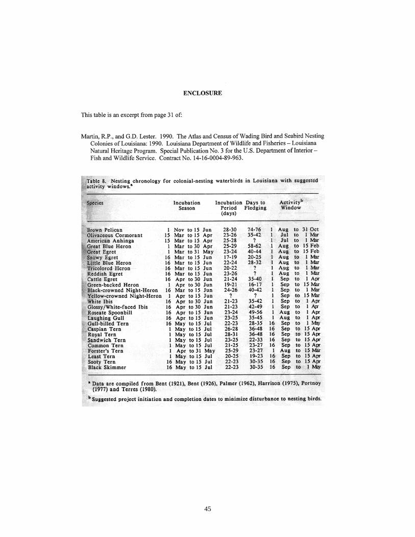
45
46
47
48
51
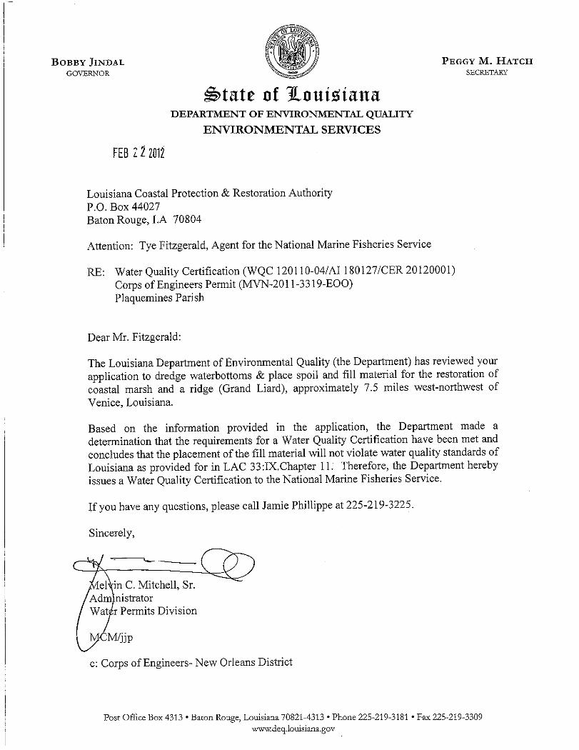
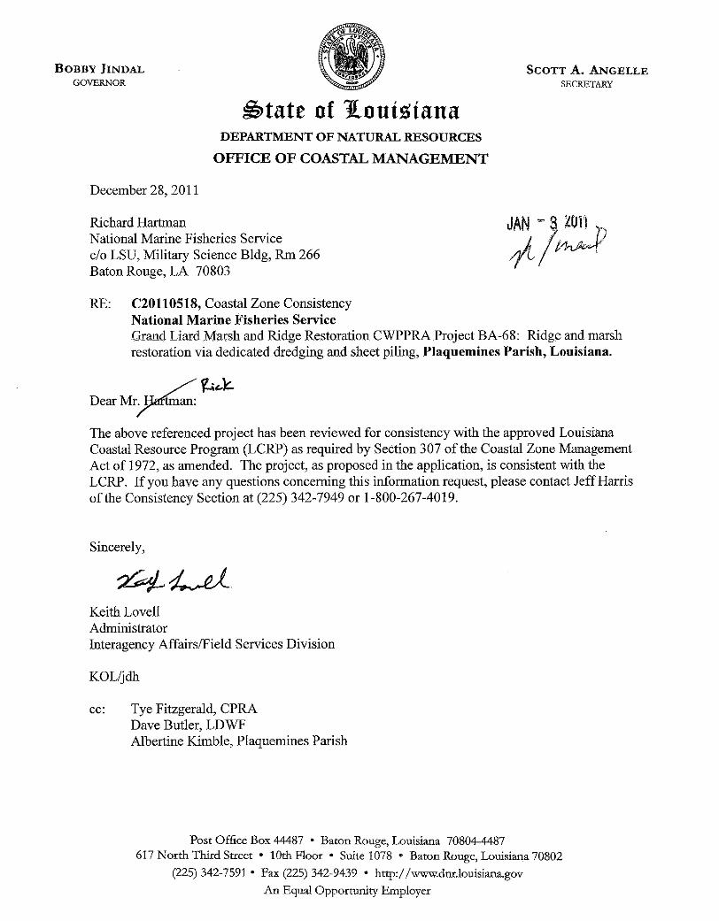
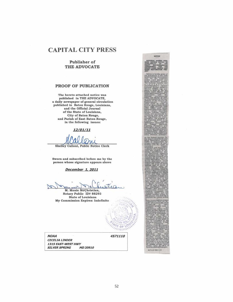
52
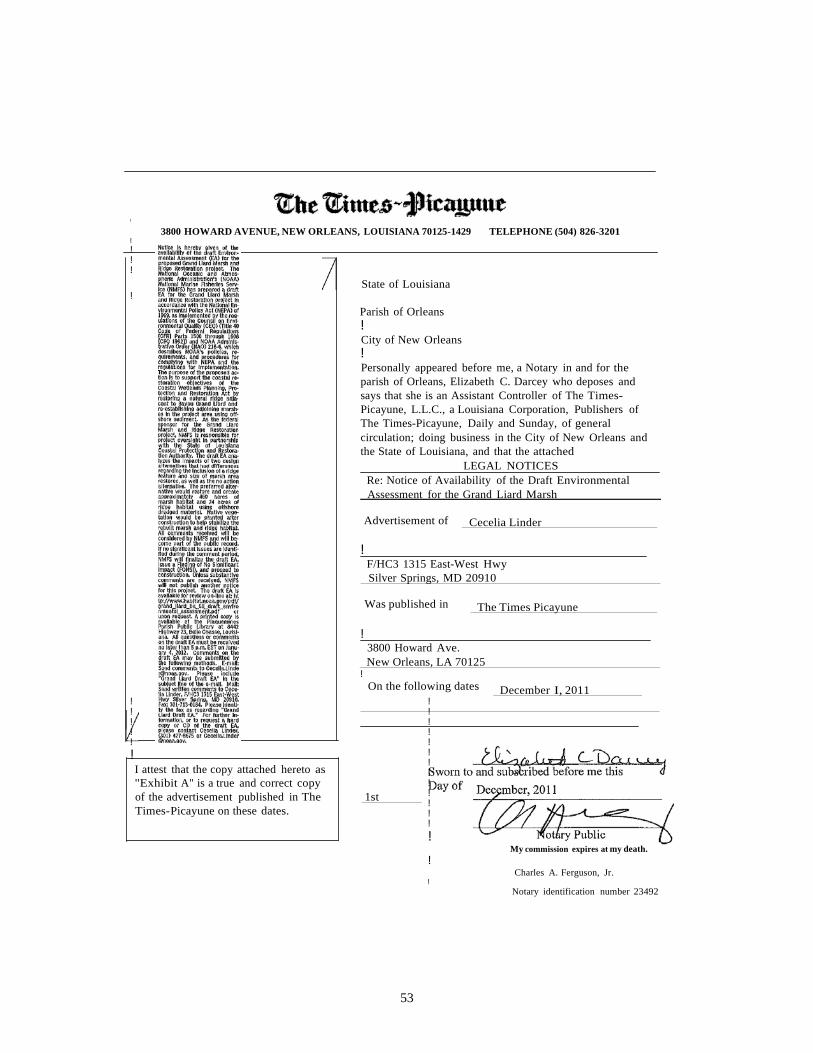
53
!
3800 HOWARD AVENUE, NEW ORLEANS, LOUISIANA 70125-1429 TELEPHONE (504) 826-3201 !
!!!
State of Louisiana !
Parish of Orleans !City of New Orleans !Personally appeared before me, a Notary in and for the parish of Orleans, Elizabeth C. Darcey who deposes and says that she is an Assistant Controller of The Times- Picayune, L.L.C., a Louisiana Corporation, Publishers of The Times-Picayune, Daily and Sunday, of general circulation; doing business in the City of New Orleans and the State of Louisiana, and that the attached
LEGAL NOTICES Re: Notice of Availability of the Draft Environmental
Assessment for the Grand Liard Marsh
Advertisement of Cecelia Linder
!F/HC3 1315 East-West Hwy
Silver Springs, MD 20910
Was published in The Times Picayune
!3800 Howard Ave.
New Orleans, LA 70125 !
On the following dates December I, 2011 !!!!!
!I attest that the copy attached hereto as "Exhibit A" is a true and correct copy of the advertisement published in The 1st Times-Picayune on these dates.
!!!!!!!!!!!!!
!My commission expires at my death.
!Charles A. Ferguson, Jr.
!
Notary identification number 23492
54