1
706000 708000 710000 712000 714000 716000 718000 4485000 4486000 4487000 4488000 4489000 4490000 4491000 4492000 4493000 12,896 Acres of Water 74 Miles of Shoreline Auglaize and Mercer Counties Grand Lake St. Marys Grand Lake St. Mary's Fishing Map Facilities Legend Roads Boat Ramp Your purchase of fishing equipment and motor boat fuels supports sport fish restoration and boating access facilities. ! y County and Township 0 0.2 0.4 0.6 0.8 Miles ! r ! b é ç ! !! !r - " ! 9 ! x ! 5 ! _ ! 7 " ! < ! @ ¤ é ! « ! o Ë Ë Ë Ë ( / Camping Swimming Accessible Pier/Dock Shelter House Lighthouse Marina Boat/Swim Area Restrooms Picnic Area Park Office Fishing Access Grand Lake St. Mary's State Park Waterfowl Refuge Area No Fishing Zone Boat Channel Marker U.S. Route Open Zone ¤ é ! « ¤ é ! « ¤ é ! « ¤ é ! « ¤ é ! « ¤ é ! « ¤ é ! « ¤ é ! « ¤ é ! « ¤ é ! « ¤ é ! « ¤ é ! « ¤ é ! « ¤ é ! « ¤ é ! « ¤ é ! « ¤ é ! « 1 2 3 4 5 6 7 8 9 10 11 12 13 14 15 16 17 Southmoor Shores Rustic Haven Harmon's Landing Little Chickasaw Big Chickasaw Behm's Landing Club Island Bayview Marina Cottonwood Park Windy Point Marina Montezuma Bay Celina Kozy Marina State Park Campground East Bank Marina It's It Ohio Marine ! !! !r - " " ! < Windy Point Safety Island 3 0 0 ' N o W a ke ! y ( / 127 ¤ é ! « 1 ¤ é ! « 2 ¤ é ! « 3 ¤ é ! « 4 ¤ é ! « 5 ¤ é ! « 6 ¤ é ! « 7 ¤ é ! « 8 ¤ é ! « 9 Windy Pt. Rd. Karafit Rd. Kittle Rd. ! y " ! < ! 5 ! 7 ! _ ! b ¤ é ! « 10 ¤ é ! « 11 ¤ é ! « 17 2 4 " ! < ! 7 ! 5 ! b ( / 127 Spillway ! _ ! y ¤ é ! « 12 ! o ! !! !r - " ¤ é ! « 13 Harbor Pt. Dr. Boat Channel Markers ! o Rock Pile Oil Well Site 3 0 0 ' N o W a k e ¤ é ! « 14 ¤ é ! « 15 ! !! !r - " " ! < ! 5 ! y ! x ! y ! y ¤ é ! « 16 ! _ ! r ! 7 ! b State Fish Hatchery ! _ " ! < ! 7 é ç é ç é ç Harris Rd. Anderson Rd. Mercer County Auglaize County Koehn Rd. Behm Rd. Club Island Rd. ! y 6 8 10 16 6 6 2 4 4 6 4 2 4 2 B e av e r Cr e e k Schroeder Rd. L i t t l e C h i c k a s a w C r e e k Pr a i r ie C re e k Monroe Rd. 300 ' NO W A KE 3 0 0 ' N O W AK E 4 C o ld w a t er C re ek C h ic k a s a w C re e k ! o (No Wake at Night) Revised: 2018 State Route 29 703 29 364 219 219 703 Wetlands " ! < " ! < " ! < ! r ! !! !r - " é ç ! b ! y ! !! !r - " ! 9 ! 5 ! r ! @ ! y Map displayed with graticules using UTM NAD 83 Zone 16 projection. Contour intervals are in 2 ft increments. Depths based on normal summer pool elevation of 871 ft. Reservoir last surveyed: 2004 Contours and depths shown on this map may change with fluctuating lake levels and alteration of the lake bottom. This map is not suitable for navigation. CELINA MONTEZUMA ST. MARY'S Mercer Co. Game Refuge Headquarters

Grand Lake St. Marys - Wildlife Homewildlife.ohiodnr.gov/Portals/wildlife/Maps/Lake Maps/PDFs... · Grand Lake St. Marys G r a n d i L a k e A S t. M a r y ' s F i s h i n g M a p

Embed Size (px)

Citation preview

706000 708000 710000 712000 714000 716000 718000

4485

000

4486

000

4487

000

4488

000

4489

000

4490

000

4491

000

4492

000

4493

000

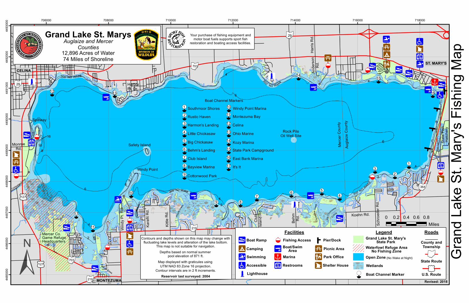
12,896 Acres of Water74 Miles of Shoreline

Auglaize and MercerCounties

Grand Lake St. Marys

Gran

d Lak

e St. M

ary's

Fishin

g Map

Facilities Legend RoadsBoat Ramp

Your purchase of fishing equipment andmotor boat fuels supports sport fish

restoration and boating access facilities.

!y County andTownship

0 0.2 0.4 0.6 0.8Miles

!r

!b

éç

!!!!r-"!9

!x

!5

!_ !7

"

!

<

!@

¤é

!«!o

Ë ËËË (/

CampingSwimmingAccessible

Pier/Dock

Shelter HouseLighthouse

Marina

Boat/SwimArea

Restrooms

Picnic AreaPark Office

Fishing Access Grand Lake St. Mary'sState Park

Waterfowl Refuge AreaNo Fishing Zone

Boat Channel Marker U.S. Route

Open Zone

¤é

¤é

¤é

¤é

¤é

¤é

¤é

¤é

¤é

¤é

¤é

¤é

¤é

¤é

¤é

¤é

¤é

123456789

1011121314151617

Southmoor ShoresRustic HavenHarmon's LandingLittle ChickasawBig ChickasawBehm's LandingClub IslandBayview MarinaCottonwood Park

Windy Point MarinaMontezuma BayCelina

Kozy MarinaState Park CampgroundEast Bank MarinaIt's It

Ohio Marine

!!!!r-"

"

!

<

Windy Point

Safety Island

300' No Wake

!y(/127

¤é

!«1

¤é

!«2¤é

!«3

¤é

!«4¤é

!«5

¤é

!«6

¤é

!«7

¤é

!«8

¤é

!«9

Wind

y Pt. R

d.

Karaf

it Rd.

Kittle

Rd.!y

"

!

<

!5

!7

!_

!b

¤é

!«10

¤é

!«11

¤é

!«17

2

4

"

!

<

!7!5!b

(/127

Spillway

!_!y

¤é

!«12!o

!!!!r-" ¤é

!«13HarborPt. Dr.

Boat Channel Markers

!o

Rock PileOil Well Site

300 ' N o Wake

¤é

!«14

¤é

!«15

!!!!r-"

"

!

<!5

!y

!x

!y!y

¤é

!«16

!_!r

!7!b

State

Fish

Hatch

ery

!_"

!

<

!7

éç

éç

éç

Harris

Rd.

Ande

rson

Rd.

Merce

r Cou

ntyAu

glaize

Cou

nty

Koehn Rd.

Behm Rd

.

Club

Islan

d Rd.

!y

6

810

16

6

6

24

4

6

4

2

42

Be aver Creek

Schro

eder

Rd.

Little

Chicka

saw

Creek

Prairie

Creek

MonroeRd.

300' NO WAKE

300 ' NO WAKE

4

Coldwater Creek

Chick

asaw

Cree

k!o

(No Wake at Night)

Revised: 2018

State Route

29

703

29

364

219

219

703Wetlands

"

!

<

"

!

<

"

!

<

!r!

!!!r-"

éç!b

!y!

!!!r-"

!9!5

!r

!@

!y

Map displayed with graticules using UTM NAD 83 Zone 16 projection.

Contour intervals are in 2 ft increments.

Depths based on normal summer pool elevation of 871 ft.

Reservoir last surveyed: 2004

Contours and depths shown on this map may change withfluctuating lake levels and alteration of the lake bottom.

This map is not suitable for navigation.

CELINA

MONTEZUMA

ST. MARY'S

Mercer Co.Game RefugeHeadquarters