Embed Size (px)
Citation preview

MERRIFIELD ROAD RED RIVER BRIDGE FEASIBILITY STUDY Grand Forks – East Grand Forks Metropolitan Planning Organization
January 2005
Appendix G
Grand Forks County Hazardous Materials Flow Update

G-0
APPENDIX G
Grand Forks County Hazardous Materials Flow Study Update
(DRAFT)
January 2005

G-1
Introduction: In conjunction with a transportation study being conducted in the southern portion of the City of Grand Forks metropolitan area, the Grand Forks/East Grand Forks MPO requested a review and update of the 1993-1994 Grand Forks County Hazardous Materials Flow Study. This update consisted of obtaining and reviewing available data regarding hazardous materials, spills, and hazardous waste generators both from mobile and stationary sources. The purpose of the Hazardous Material Flow Study is to identify what types and amounts of hazardous materials are stored or transported in a given area. This information can be used by emergency response personnel to aid in planning for responses to hazardous material related incidents. Under the Emergency Planning and Community Right-to-Know Act (EPCRA – established in 1986 as part of the Superfund Amendments and Reauthorization Act), such planning is required. Area Overview: Grand Forks County is located in the northeastern part of North Dakota. Data from the 2000 census indicates that the county has a population of just over 66,000. Data further indicates that roughly 11,500 people live in rural portions of the county, while approximately 54,500 people live in the county’s urban areas. Major population centers include the city of Grand Forks and the Grand Forks Air Force Base. The city of Grand Forks is also home to the University of North Dakota. The figure below presents the location of Grand Forks County, along with the location of cities and major transportation infrastructure.

G-2
Population: The 1993-1994 Hazardous Material Flow Study included population data for cities in Grand Forks County to show the number of people that could require notification or evacuation in the event of an emergency. The table below provides updated population information.
Census Data Summary - Cities in Grand Forks County, ND
City 1990 Population1 2000 Population
Percent Change
Emerado 482 510 5.8% Gilby 262 243 -7.3% Grand Forks 49425 49321 -0.2% Grand Forks Air Force Base2 8343 4832 -42.1%
Inkster 94 102 8.5% Larimore 1459 1433 -1.8% manvel 334 370 10.8% Niagara 78 57 -26.9% Northwood 1166 959 -17.8% Reynolds 109 350 221.1% Thompson 928 1006 8.4%
11990 Population data taken from 1993-1994 Hazardous Materials Flow Study 2It should be noted that the population at GFAFB has likely changed since 9/11/01 in response to military activities in Afghanistan and Iraq
G-3
Water: The 1993-1994 Study identified one carrier of hazardous materials using the water mode of transportation. This was the Dakota Queen River Boat which operated on the Red River of the North. In the mid-1990s, the Dakota Queen was taken out of service. The only hazardous material issues on the Red River of the North consist of fuel associated with fishing and pleasure craft that use the river during spring, summer, and fall. Air: In Grand Forks County, key air transporters of hazardous materials via the air mode of transportation include the Grand Forks International Airport, Federal Express, the Grand Forks Air Force Base, and a number of agricultural aerial spraying services. Attempts were made to contact each of these key air transporters; the table on the following page below presents the results of the contacts as of January 7, 2005.

G-4
Hazardous Materials Transported by Air/Stored at Air Facilities
Facility Address City Material Amount Frequency Hazard Class Comments
GFK International Airport Airport Road Grand Forks --- --- --- ---
Need to check back on 1-14-05 to determine if information is available
Federal Express 2133 Air Cargo Dr. Grand Forks --- --- --- ---
FedEx staff indicated that a manager would need to discuss this issue; left contact information for manager to call back.
Bakke Flying Service --- Larimore --- --- --- --- No answer
Jenson Airspray --- Grand Forks --- --- --- ---
Number no longer in service; no forwarding information provided
Knutson Flying Service --- Thompson --- --- --- --- Number changed to a non-listed phone number
Morten Helicopters --- Larimore Penncozeb 3000 lb Yearly 6 fungicide Morten Helicopters --- Larimore Actara 500 lb Yearly 6 insecticide Morten Helicopters --- Larimore Echo or Bravo 4000 lb Yearly 6 fungicide
Morten Helicopters --- Larimore var. Herbicides 900 gal Yearly 6
Northwood Aero-Spray --- Northwood Aviation Fuel 12,000 gal See comment 3
Maximum amount on site at any given time
Northwood Aero-Spray --- Northwood Lorsban 150 gal See comment 6
Maximum amount on site at any given time
Northwood Aero-Spray --- Northwood Furodan 150 gal See comment 6
Maximum amount on site at any given time
Thompson Aero-Spray --- Thompson --- --- --- --- Contact attempts failed through 1-7-05; will continue attempts.

G-5
Highway: The 1993-1994 Study included information regarding hazardous materials transported by highway (truck). This information was obtained through a placard survey conducted at five locations and a poll survey. According to the previous study, the majority of the hazardous materials transported via the highway mode are Class 3 – flammable liquids, as documented at right. The placard study conducted in 1994 was performed at four locations throughout the county, decided upon by the committee commissioned to prepare that study. Even with the tremendous staff resources (including volunteer time) used for that study, the authors noted that the study lacked data and does not accurately reflect all the types of hazardous shipments that travel by truck throughout Grand Forks County (such as seasonal shipments of anhydrous ammonia). Of all modes, travel by truck is the least regulated and the regulations that do exist often rely on low-percentage enforcement interaction to police their activities. Therefore, preparation of a county-wide effort to either replicate another placard survey or use other means, remains an effort without a cost-effective and data-accurate solution. For purposes of this study, it was assumed that the percentage of hazardous materials shipped by truck throughout the County is consistent with the growth of background truck traffic and other traffic. In other words, the composition of hazardous materials is not increasing more rapidly than background truck/other vehicle traffic. In addition, it is assumed that the commodities of hazardous shipments remain generally consistent with what was studied in 1994. It is important to note that the authors of the 1994 study identified that the means available then (and now) cannot provide a level of certainty that encompasses all truck shipments (as is documented for rail, pipelines, etc…). Traffic growth across Grand Forks County and the State of North Dakota is measured through data collection stations located on highways statewide. This information is periodically published by NDDOT. For this study, growth rates were obtained from the data collection stations for similar types of highways, as documented on the following page.
Placard Survey Hazardous Cargo
Cl 3 - Flammable
Liquids, 68.0%
Cl 6 - Poison, 1.0%
Cl 8 - Corrosives,
4.9%Cl 5 - Oxidizing
Subtances, 1.0%
Cl 9 - Misc., 2.4%
Other, 5.4%
Cl 1 - Explosives,
1.0%
Cl 2 - Gases, 16.1%

G-6
North Dakota AADT Station History
y = 2309.8e0.0498x
R2 = 0.9384
y = 1376.4e0.0183x
R2 = 0.9044
y = 944.24e0.0112x
R2 = 0.6346
y = 466.3e-0.0021x
R2 = 0.02340
1000
2000
3000
4000
5000
6000
7000
1978 1979 1980 1981 1982 1983 1984 1985 1986 1987 1988 1989 1990 1992 1994 1995 1996 1997 1998
Year
AA
DT
Rural Interstate I-29
Rural Principal Arterial
Rural Minor Arterial (State)
Rural Major Collector (County)
Expon. (Rural Interstate I-29)
Annual Growth = 5.1%
Annual Growth = 1.8%
Annual Growth = 1.1%
Annual Growth = 0%

G-7
The classification of highways documented on the previous page corresponds with the four locations used for the placard survey conducted in 1994. The associated growth rates using a best-fit exponential trend line were calculated to forecast 2004 ADT data at each of the sites, as documented in the following table. The only information utilized for this study is the growth rate, as highlighted.
Survey Site Classification 1994 ADT Growth Rate
2004 ADT
1) Jct. I-29 and US Highway 2 (Grand Forks)
Rural Interstate I-29 5,125 5.1% 8,430
2) Jct. US Highway 2 & ND Highway 18 (Larimore)
Rural Principal Arterial 1,845 1.8% 2,215
3) Jct. ND Highway 15 and ND Highway 18 (Northwood)
Rural Minor Arterial (State) 1,130 1.1% 1,265
4) Jct. County Road 1 & County Road 2 (Johnstown)
Rural Major Collector (County)
465 0.0% 465
The classification of highways documented on the previous page corresponds with the four locations used for the placard survey conducted in 1994. The associated growth rates using a best-fit exponential trend line were calculated to forecast 2004 ADT data at each of the sites, as documented in the following table. The only information utilized for this study is the growth rate, as highlighted. Utilizing the calculated annual growth rates, the 2004 estimated hazardous truck shipments are documented below with the 1994 survey results.
Hazard Class Placard - 1994 SurveyLocation 1 2 3 4 5 6 7 8 9 Other Total
#1 1 13 95 0 2 2 0 8 0 5 126#2 1 10 30 0 0 0 0 1 3 0 45#3 0 6 7 0 0 0 0 1 2 6 22#4 0 4 8 0 0 0 0 0 0 0 12
Total 2 33 140 0 2 2 0 10 5 11
Hazard Class Placard - 2004 UpdateLocation 1 2 3 4 5 6 7 8 9 Other Total
#1 2 21 156 0 3 3 0 13 0 8 207#2 1 12 36 0 0 0 0 1 4 0 54#3 0 7 8 0 0 0 0 1 2 7 25#4 0 4 8 0 0 0 0 0 0 0 12
Total 3 44 208 0 3 3 0 15 6 15

G-8
Pipeline Routes: Review of pipeline infrastructure data indicates that the pipeline routes identified in the 1993-1994 Hazardous Materials Flow Study are still present, and no new pipeline infrastructure has been developed in Grand Forks County. However, some pipeline assets have changed ownership. The table below summarizes pipeline information.
Pipeline Location Materials Carried
Operating Volume
Operating Pressure
Enbridge Pipelines (North Dakota) LLC
See map below Crude Oil Information requested
Information requested
Magellan Midstream Partners LP
See map below Refined Petroleum
MAX – 21,600 Barrels per day MAX – 940 psi
Grand Forks Air Force Base Fuel Pipeline
See map below Jet Fuel Information requested
Information requested

G-9
Fixed Facility Information: Grand Forks County emergency response personnel were contacted to obtain updated Tier II reporting information. Due to post 9/11 security concerns, this information needed to be obtained through formal request by the Grand Forks/East Grand Forks MPO. Coordination on this issue is underway; updated information will be supplied as soon as it is made available. In addition to review of Tier II reports for fixed facilities in Grand Forks County, a review was conducted of hazardous waste generators. According to EPA data, a total of 147 facilities with reported hazardous waste activities existed in Grand Forks County as of December 10, 2004. The breakdown of these facility types is presented below.
Facilities Reporting Hazardous Waste Activity
Facility Category
Number of
Facilities Percentage
Large Quantity Generator 1 0.68% Small Quantity Generator 12 8.16%
Exempt Small Quanity Generator/Other 126 85.71%
Transporter 7 4.76% Treatment/Storage/Disposal 1 0.68% Total 147 100.00%
A review of spills reported to the National Response Center between 1990 and 2004 was also conducted. Fifty significant spill or rail accident events were recorded and are summarized in the table on the following pages. It should be noted that additional spills have likely been reported to other sources or have remained unreported.

G-10
Grand Forks County, North Dakota Spills/Incidents Reported to the National Response Center 1 of 5
NRC Report Number
Incident Date Street Address County City Zip
Code Suspected
Responsible Party Type of Incident
Material Released Quantity
723706 6/2/2004 3401 GATEWAY DR.
GRAND FORKS
GRAND FORKS
58203 HANSON TOYOTA/CHRYSLER DEALERSHIP
FIXED USED MOTOR OIL Unknown
707340 12/7/2003 3630 GATEWAY DRIVE
GRAND FORKS
GRAND FORKS
58203 JR SIMPLOT COMPANY
FIXED AMMONIA, ANHYDROUS Unknown
704778 11/8/2003 DEVILS LAKE SUBDIVISONMILE POST 33.16
GRAND FORKS
NIAGARA (null) (null) RAILROAD NON-RELEASE
(null) N/A
702970 10/19/2003 MILEPOST 109.9 GRAND FORKS
GRAND FORKS
(null) BNSF RAILROAD RAILROAD OIL, FUEL: NO. 2-D
25 Gallons
652418 7/30/2003 UNKNOWN SHEEN INCIDENT 1 MILE NORTH OF BASE FRONT GATEON COUNTY ROAD 3
GRAND FORKS
GRAND FORKS AFB
(null) (null) UNKNOWN SHEEN
UNKNOWN OIL
Unknown
610600 6/12/2002 BNSF RAIL ROAD MILE POST 14.52770 17TH AVE NORTH EAST
GRAND FORKS
EMERADO (null) (null) RAILROAD (null)
N/A
576062 8/8/2001 IN THE ALLEY900 BLOCK OF SOUTH 10TH ST
GRAND FORKS
GRANDS FORKS
(null) EXCEL ENERGY CORP.
FIXED UNKNOWN OIL Unknown
573617 7/19/2001 NORTH 47TH STREET AND GATEWAY DRIVE
GRAND FORKS
(null) (null) (null) MOBILE OIL, FUEL: NO. 2-D Unknown
569560 5/11/2001 915 LETNES DRIVE
GRAND FORKS
GRAND FORKS
(null) XCEL ENERGY FIXED HYDRAULIC OIL Unknown

G-11
Grand Forks County, North Dakota Spills/Incidents Reported to the National Response Center 2 of 5
NRC Report Number
Incident Date Street Address County City Zip
Code
Suspected Responsible
Party
Type of Incident
Material Released Quantity
542979 9/10/2000 LAST PAVED ROAD ON SW SIDE OF THE UNIVERSTY OF NORTH DAKOTACAMPUS DRIVEMAN HOLE #4
GRAND FORKS
GRAND FORKS
(null) (null) PIPELINE OIL, FUEL: NO. 2-D
Unknown
540053 8/26/2000 NIAGRA DAMN RD. GRAND FORKS
NIAGRA (null) (null) RAILROAD NON-RELEASE
(null) N/A
539097 8/18/2000 CALLER HAD NO PHYSICAL LOCATION
GRAND FORKS
POWELL (null) BNSF RAILROAD
RAILROAD OIL: DIESEL 1000 Gallons
536706 7/27/2000 UNKNOWN GRAND FORKS
LARIMORE (null) (null) RAILROAD NON-RELEASE
(null) N/A
499986 9/24/1999 CF INDUSTRIESGRAND FORKS TERMINALHIGHWAY 81, NORTH
GRAND FORKS
GRAND FORKS
(null) CF INDUSTRIES FIXED AMMONIA, ANHYDROUS
Unknown
490476 7/8/1999 803 SOUTH WASHINGTON ST
GRAND FORKS
GRAND FORKS
(null) CENEX INC MOBILE OIL, FUEL: NO. 2-D
40 Gallons
483632 5/13/1999 300 FEET EAST OF MAINGATE
GRAND FORKS
GRAND FORKS AFB
58205 USAF GRAND FORKS
FIXED SEWAGE 100
Gallons
465406 11/25/1998 2992 NORTH WASHINGTON ST
GRAND FORKS
GRAND FORKS
58206 TERRA INTERNATIONAL
CONTINUOUS (null) Unknown

G-12
Grand Forks County, North Dakota Spills/Incidents Reported to the National Response Center 3 of 5
NRC Report Number
Incident Date Street Address County City Zip
Code
Suspected Responsible
Party
Type of Incident
Material Released Quantity
457560 9/29/1998 DOT NUMBER:UNKNOWNSTREET NAME:UNKNOWN
GRAND FORKS
GRANDIN (null) (null) RAILROAD NON-RELEASE
(null)
N/A
453475 9/2/1998 GRAND FORKS BNSF STATION
GRAND FORKS
GRAND FORKS
(null) (null) RAILROAD (null) N/A
452346 8/26/1998 3930 GATEWAY DRIVEWILLIAMS GRAND FORKSTERMINAL
GRAND FORKS
GRAND FORKS
58201 (null) FIXED OIL: DIESEL 400
Gallons
436303 5/10/1998 6105 GATEWAY DRIVE GRAND FORKS
GRAND FORKS
58201 NEW VISION FIBERGLASS
FIXED STYRENE Unknown
435022 5/1/1998 MILEPOST:96CROSS ST:32ND AVE SOUTHDOT:86739Y
GRAND FORKS
MERRIFIELD (null) BNSF RAILROAD
RAILROAD NON-RELEASE
OIL, FUEL: NO. 2-D 500
Gallons
386566 5/7/1997 CORNER OF DEMARS AVE ANDCOLUMBUS ST
GRAND FORKS
GRAND FORKS
(null) US ARMY RESERVE 96TH RSC
FIXED OIL, FUEL: NO. 2-D 0.25
Gallons
386157 5/5/1997 GRAND FORKS HERALD120 NORTH 4TH STREET
GRAND FORKS
GRAND FORKS
(null) HAZCON FIXED OTHER OIL Unknown
384382 4/21/1997 2002 NORTHWEST ST GRAND FORKS
GRAND FORKS
58206 TERRA INDUSTRIES INC.
FIXED UREA Unknown
384385 4/21/1997 2022 NORTHWEST ST GRAND FORKS
GRAND FORKS
58206 TERRA INDUSTRIES INC.
FIXED (null) None Reported
384268 4/20/1997 417 NORTH WASHINGTON GRAND FORKS
GRAND FORKS
(null) UNITED PARCEL SERVICE
FIXED GASOLINE: AUTOMOTIVE (4.23G PB/G
25 Gallons

G-13
Grand Forks County, North Dakota Spills/Incidents Reported to the National Response Center 4 of 5
NRC Report Number
Incident Date Street Address County City Zip
Code
Suspected Responsible
Party
Type of Incident
Material Released Quantity
384370 4/20/1997 4200 NORTH WASHINGTON ST
GRAND FORKS
GRAND FORKS
(null) UNITED PARCEL SVC
FIXED GASOLINE: AUTOMOTIVE (UNLEADED)
Unknown
361948 9/22/1996 2215 BACON ROAD GRAND FORKS
GRAND FORKS
58201 A & J FERTERLIZER
CONTINUOUS (null) Unknown
361562 9/18/1996 319 CES/CEVP525 6TH AVE
GRAND FORKS
GRAND FORKS
(null) GRAND FORKS AFB
MOBILE OIL, FUEL: NO. 2
8000 Gallons
351335 7/11/1996 SW OF TANK FARM GRAND FORKS
GRAND FORKS
(null) USAF-GRAND FORKS AFB
MOBILE HYDRAULIC OIL
50 Gallons
341037 5/13/1996 GRAND FORKS TERMINALNORTH HWY 81
GRAND FORKS
GRAND FORKS
(null) CF INDUSTRIES
FIXED AMMONIA, ANHYDROUS 10
Pounds
296192 6/18/1995 319 CES/CEV525 6TH AVE
GRAND FORKS
GRAND FORKS
58205 USAF-GRAND FORKS AFB
FIXED ETHYLENE GLYCOL (30%)
300 Gallons
281113 2/24/1995 VALVE PIT OFF OF PARKINGRAMP FOR AIRCRAFT
GRAND FORKS
GRAND FORKS
58205 USAF- GRAND FORKS AFB
FIXED (null)
Unknown
278687 2/3/1995 3630 E. GATEWAY DRIVEREFRIGERATION UNIT
GRAND FORKS
GRAND FORKS
58203 J. R. SIMPLOT CO.
FIXED (null) Unknown
270134 11/17/1994 (null) GRAND FORKS
(null) (null) USAF-GRAND FORKS AFB
AIRCRAFT JET FUEL: JP-4 10,000 Pounds
251563 7/23/1994 HIGHWAY NO.2INTERSECTION OF HIGHWAYNO.2 AND HIGHWAY NO.29
GRAND FORKS
GRAND FORKS
(null) GORSKI BULK TRANSPORT INC
MOBILE (null)
Unknown

G-1
4
Gra
nd F
orks
Cou
nty,
Nor
th D
akot
a S
pills
/Inci
dent
s R
epor
ted
to th
e N
atio
nal R
espo
nse
Cen
ter
5 of
5
NR
C
Rep
ort
Num
ber
Inci
dent
D
ate
Str
eet
Add
ress
C
ount
y C
ity
Zip
Cod
e
Sus
pect
ed
Res
pons
ible
P
arty
Type
of
Inci
dent
M
ater
ial R
elea
sed
Qua
ntity
2228
74
2/22
/199
4 46
0 S
TE
EN
AV
E
GR
AN
D
FOR
KS
G
RA
ND
FO
RK
S A
FB
(nul
l) U
SA
F-G
RA
ND
FO
RK
S
MO
BIL
E
GA
SO
LIN
E:
AU
TO
MO
TIV
E
(UN
LEA
DE
D)
100
Gal
lons
1893
59
7/29
/199
3 (n
ull)
GR
AN
D
FOR
KS
G
RA
ND
FO
RK
S
(nul
l) (n
ull)
RA
ILR
OA
D
NO
N-
RE
LEA
SE
(nul
l) N
/A
1458
16
11/1
8/19
92
3930
GA
TE
WA
Y
DR
G
RA
ND
FO
RK
S
GR
AN
D
FOR
KS
(n
ull)
WIL
LIA
MS
P
IPE
LIN
E
FIX
ED
P
AR
AD
YN
E(F
UE
L O
IL
AD
DIT
IVE
) 40
0 G
allo
ns
1426
96
10/1
3/19
92
GR
AN
D F
OR
KS
C
OU
NT
Y
RD
NO
.20
GR
AN
D
FOR
KS
LA
RIM
OR
E
(nul
l) (n
ull)
MO
BIL
E
AM
MO
NIA
, A
NH
YD
RO
US
U
nkno
wn
1422
96
10/1
3/19
92
(nul
l) G
RA
ND
FO
RK
S
NO
RT
HW
OO
D
5826
7 (n
ull)
FIX
ED
A
MM
ON
IA,
AN
HY
DR
OU
S
140
Gal
lons
1280
72
7/21
/199
2 N
OR
TH
HW
Y 8
1 G
RA
ND
FO
RK
S
GR
AN
D
FOR
KS
(n
ull)
CF
IND
US
TR
IES
FI
XE
D
AM
MO
NIA
, A
NH
YD
RO
US
17
2 P
ound
s
1185
87
5/20
/199
2 H
WY
2
GR
AN
D
FOR
KS
LA
RIM
OR
E
5637
8 K
AN
E
TR
AN
SP
OR
T
INC
MO
BIL
E
AM
MO
NIA
, A
NH
YD
RO
US
U
nkno
wn
1179
30
5/15
/199
2 H
WY
81
NO
RT
H
GR
AN
D
FOR
KS
G
RA
ND
FO
RK
S
(nul
l) C
F IN
DU
ST
RIE
S
FIX
ED
A
MM
ON
IA,
AN
HY
DR
OU
S
600
Pou
nds
7192
0 5/
14/1
991
INT
ER
SE
CT
ION
O
F 11
TH
A
ND
4TH
ST
GR
AN
D
FOR
KS
G
RA
ND
FO
RK
S
(nul
l) N
OR
TH
ER
N
ST
AT
ES
P
OW
ER
FIX
ED
O
IL, M
ISC
: T
RA
NS
FOR
ME
R
7 G
allo
ns
6645
3 4/
3/19
91
CT
Y R
D B
-3
GR
AN
D
FOR
KS
G
RA
ND
FO
RK
S
(nul
l) U
SA
F U
NK
NO
WN
S
HE
EN
U
NK
NO
WN
OIL
U
nkno
wn
7829
8 2/
1/19
91
RT
1
GR
AN
D
FOR
KS
N
IAG
AR
A
5826
6 (n
ull)
FIX
ED
O
IL, M
ISC
: MO
TO
R
Unk
now
n
1900
1 4/
25/1
990
2720
GA
TE
WA
Y
DR
G
RA
ND
FO
RK
S
GR
AN
D
FOR
KS
(n
ull)
NO
RT
HE
RN
S
TA
TE
S
PO
WE
R C
O
FIX
ED
P
OLY
CH
LOR
INA
TE
D
BIP
HE
NY
LS, <
500
P
PM
20
G
allo
ns
Dat
a ob
tain
ed fr
om
http
://w
ww
.nrc
.usc
g.m
il/w
dbcg
i/wdb
cgi.e
xe/W
WW
US
ER
/WE
BD
B.F
OIA
_QU
ER
Y.s
how
G-15
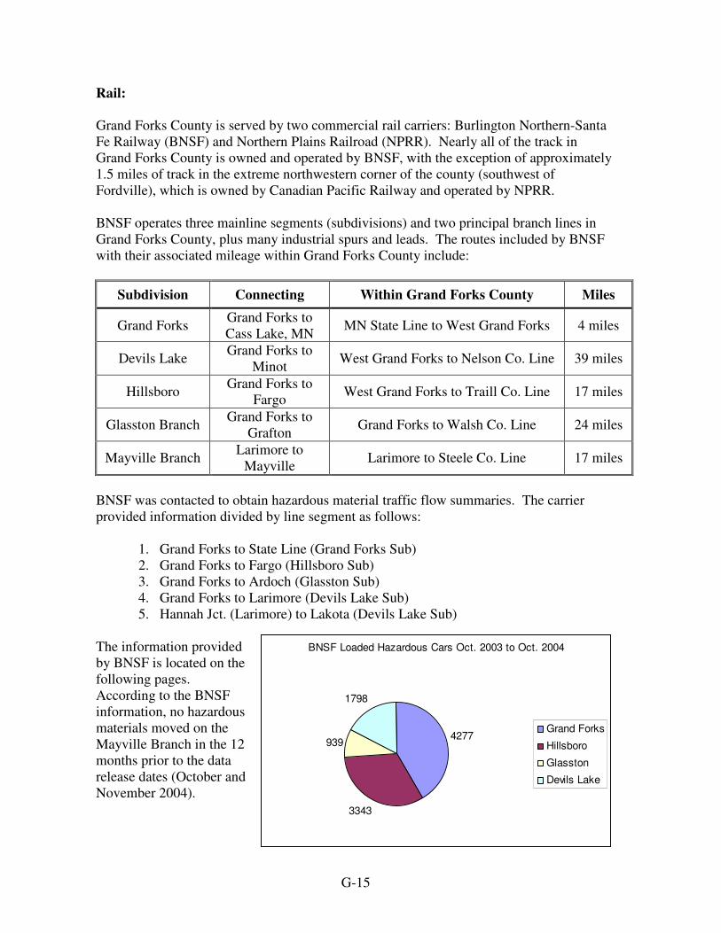
Rail: Grand Forks County is served by two commercial rail carriers: Burlington Northern-Santa Fe Railway (BNSF) and Northern Plains Railroad (NPRR). Nearly all of the track in Grand Forks County is owned and operated by BNSF, with the exception of approximately 1.5 miles of track in the extreme northwestern corner of the county (southwest of Fordville), which is owned by Canadian Pacific Railway and operated by NPRR. BNSF operates three mainline segments (subdivisions) and two principal branch lines in Grand Forks County, plus many industrial spurs and leads. The routes included by BNSF with their associated mileage within Grand Forks County include:
Subdivision Connecting Within Grand Forks County Miles
Grand Forks Grand Forks to Cass Lake, MN MN State Line to West Grand Forks 4 miles
Devils Lake Grand Forks to Minot West Grand Forks to Nelson Co. Line 39 miles
Hillsboro Grand Forks to Fargo West Grand Forks to Traill Co. Line 17 miles
Glasston Branch Grand Forks to Grafton Grand Forks to Walsh Co. Line 24 miles
Mayville Branch Larimore to Mayville Larimore to Steele Co. Line 17 miles
BNSF was contacted to obtain hazardous material traffic flow summaries. The carrier provided information divided by line segment as follows:
1. Grand Forks to State Line (Grand Forks Sub) 2. Grand Forks to Fargo (Hillsboro Sub) 3. Grand Forks to Ardoch (Glasston Sub) 4. Grand Forks to Larimore (Devils Lake Sub) 5. Hannah Jct. (Larimore) to Lakota (Devils Lake Sub)
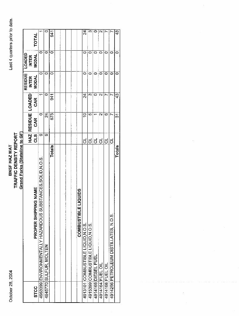
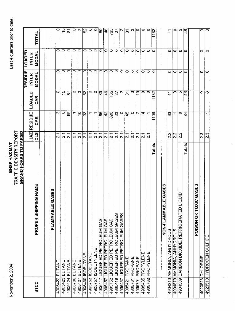
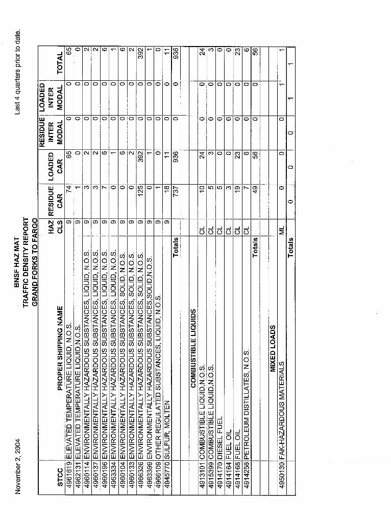
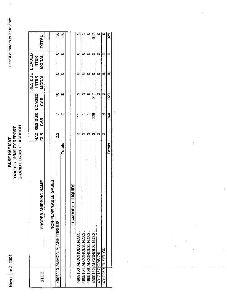
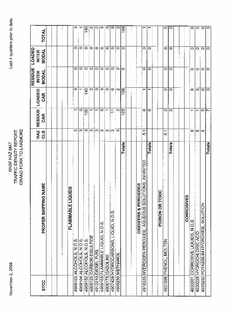
The information provided by BNSF is located on the following pages. According to the BNSF information, no hazardous materials moved on the Mayville Branch in the 12 months prior to the data release dates (October and November 2004).
BNSF Loaded Hazardous Cars Oct. 2003 to Oct. 2004
4277
3343
939
1798
Grand Forks
Hillsboro
Glasston
Devils Lake

G-16
Grand Forks Subdivision
Flammable Gas, 2316
Poision/Toxic Gas, 0
Flammable Liquids, 201
Flammable Solids, 1
Oxidizers & Organic
Peroxides, 69
Misc. Class 9, 941
Combustible Liquids, 43
Corrosives, 42
Posion / Toxic, 229
Non-Flammable Gas, 435
Hillsboro Subdivision
Poision/Toxic Gas, 0
Flammable Liquids, 831Flammable
Solids, 1
Oxidizers & Organic
Peroxides, 77
Flammable Gas, 1132Misc. Class
IX, 936
Combustible Liquids, 56
Corrosives, 53
Posion / Toxic, 210
Non-Flammable
Gas, 46
Devils Lake SubdivisionOxidizers &
Organic Peroxides, 1
Flammable Liquids, 158
Flammable Gas, 1182
Misc. Class IX, 67 Combustible
Liquids, 2
Corrosives, 3
Non-Flammable Gas, 384
Glasston Subdivision
Flammable Liquids, 929
Non-Flammable
Gas, 10

G-17


![Grand Forks herald (Grand Forks, N.D.). 1917-12-01 [p ]. · Grand Forks herald (Grand Forks, N.D.). 1917-12-01 [p ]](https://img.pdfslide.us/doc/110x75/5e9b4cea4169af71771cee98/grand-forks-herald-grand-forks-nd-1917-12-01-p-grand-forks-herald-grand.jpg)