Embed Size (px)
Citation preview

Chapter One
INVENTORY
1-1
INVENTORYCHAPTER ONE
The Terminal Area Plan for Grand Canyon National Park Airport (GCN) was undertaken by the Arizona Department of Transportation Multimodal Planning Division (ADOT/MPD) Aeronautics Group to evaluate and recommend a terminal area layout to meet anticipated terminal area demands. This plan is intended to include, but not be limited to:
Recommendations for the location of the terminal building and a general terminal building layout.
A motor vehicle circulation plan that shows: 1) access to any new structures in the southern portion of the terminal area; 2) motor vehicle parking for buses and shuttles to the Grand Canyon National Park; and 3) general aviation fixed base operator traffic flow.
Motor vehicle parking for the terminal area and terminal building, and pedestrian access to the terminal building that minimizes walking distance.
A development plan that supports the airport’s goal of maximizing revenue and maintaining the airport on a self-sustaining basis.
Recommendations for future uses and modifications, if needed, of the existing terminal building.
Identification of potential problems in the development of the terminal area.
The inventory of existing conditions and facilities is the first step in any facility planning process. This infor-

1-2
mation was collected through on-site investigations, interviews with ADOT staff, air traffic control, tenants, and others as well as online and literature searches. AIRPORT SETTING Grand Canyon National Park Airport is located immediately south of the un-incorporated community of Tusayan in the Kaibab National Forest, and six miles south of the Grand Canyon Na-tional Park. The airport is accessible from Arizona Highway 64 which con-tinues northward through Tusayan to the main gate of the park’s South Rim. While the park hosts approximately 4.5 million visitors annually, this area of Coconino County is uniquely remote from incorporated cities and popula-tion centers. The population of Tu-sayan is just over 600. The city of Wil-liams is the closest incorporated city at 60 miles to the south, while the county seat of Flagstaff is located 81 miles southeast. Exhibit 1A depicts the regional setting for GCN. GCN is owned by the State of Arizona and operated by ADOT. It is classified in the Federal Aviation Administra-tion’s (FAA’s) National Plan of Inte-grated Airport Systems (NPIAS) as a small hub commercial service airport. Small hub airports are defined as those commercial service airports en-planing between 0.05% and 0.25% of the total U.S. enplanements. In 2008, the airport’s enplanement (commercial service boardings) totaled 366,890. Pulliam Airport in Flagstaff is the next closest commercial service air-port. The next closest general aviation airport is Valle Airport located 18 miles to the south.
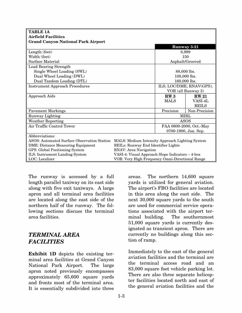
The airport’s commercial activity is currently dominated by commercial tour operations. In fact, these air taxi operators comprised 95 percent of the airport’s operations (takeoffs and land-ings) in 2008. Some air tours origi-nate at GCN while others come to the airport from locations such as Las Ve-gas and Phoenix. Some deplane and board buses and other vehicles for land tours of the park as well. Exhi-bit 1B depicts the area airspace and other area airports. AIRFIELD FACILITIES Exhibit 1C and Table 1A depict the existing airfield facilities at Grand Canyon National Park Airport. GCN has a single Runway 3-21 that is 8,999 feet long and 150 feet wide. The grooved asphalt runway has a pave-ment strength rating of 88,000 pounds single wheel gear loading (SWL), 108,000 pounds dual wheel gear load-ing (DWL), and 160,000 pounds dual tandem gear loading (DTL). The runway has medium intensity runway edge lighting (MIRL). Run-way 3 is equipped with an instrument landing system (ILS) with minimums down to ¾-mile. Runway 3 also has several nonprecision approach proce-dures available that are identified in Table 1A. Runway 3 is equipped with a 1,400-foot medium intensity ap-proach light system (MALS). Runway 21 does not have any straight-in in-strument approach procedures. Run-way 21 is equipped with runway end identifier lights (REILs) as well as a four-box visual approach slope indica-tor (VASI-4).

NNN
Great Basin NP
ARIZONA
64
Great Basin NP
Glen RAGlen yon NRA
51
40
10
15
70
17
88
180
9595
93
89
PrescoPrescotNFNF
Kaibab NFKaibab NF
Tonto NFTonto NF
RoxRox
KanabKanab
MesquiteMesquite
yyyooonnWaterWater
BunkervilleBunkervilleGlendaleGlendale
OvertonOverton
obooooooobbLakeLake
Las VegasLas Vegas
Blue
SupaiSupai
JeanJean
Grand CanyonGrand Canyon
TuuuCityCity
TusayanTusayan
aCimaa
ChlorideChloride
GGGMountainMountain
QuiveroQuivero
BerryBerry
KingmanKingman
SeligmanSeligmanSeligmanWilliamsWilliams
NeedlesNeedlesEssexEssex
FlagstaffFlagstaff
zCadizz
SedonaSedona
Lake Havasu CityLake Havasu CityLake Havasu City
JeromeJerome
PrescottPrescott
BluewaterBluewater
MayerMayer
CongressCongress
MidlandMidlandBouseBouse
VicksburgVicksburgQuartzsiteQuartzsiteBlytheBlytheWittmannWittmann refreearefree
Niland
SurprisSurpris
GoodyearGoodyear
PhoenixPhoenix
PrestoLundLund
Garrison FlowellRedmond Salina
KanoshKanoshEmeryEmery
RockRock
SunnysideSunnyside
GlenwoodGlenwood
MilfordMilford MarysvaleMarysvale
MinersvilleMinersville
CaseltonCaselton
KingstonKingstonTeasdaleTeasdale
LundLund
eTempiutee
ModenaModena
HikoHikoSummitSummitEnochEnoch
AlamoAlamo
HatchHatch
ElginElgin
New HarmonyNew Harmony
St. GeorgeSt. George
AltonAlton
NEVADA
CALIFORNIA
UTAH
ARIZONA
Grand CanyonNational Park Airport
Grand CanyonNational Park Airport
Kershaw-Ryan State Park
Kershaw-Ryan State Park
State ParkState Park
ValleyValleyof Fireof Fire
GrandGrandCanyon NPCanyon NP
Lake Mead NRALake Mead NRA
SpringSpringValleyValley
State ParkState Park
Coconino NFCoconino NF
Dixie NFDixie NF
CapitolCapitolReef NPReef NP
ZionZionNPNP
PagePage
rCityCity
SearchlightSearchlight
LaughliLaughliBullheadBullhead
KaibabKaibab
NORTHNORTHNORTH
NOT TO SCALE
Exhibit 1A VICINITY MAP
08M
P08
-1A
-3/2
5/09

NeedlesVORTACNeedlesVORTAC
V 208V 208V 208V 208V 208V 208V 208
V 293V 293V 293
V 20
8V
208
V 20
8V
208
V 20
8V
208
V 20
8
V 29
3V
293
MARBLE CANYONMARBLE CANYONMARBLE CANYON
TUBA CITYTUBA CITYTUBA CITY
STOUTSTOUTSTOUTST. GEORGEST. GEORGEST. GEORGE
COLORADOCITY
COLORADOCITY
COLORADOCITY
PERKINSPERKINSPERKINS
ECHO BAYECHO BAY
KANABKANABKANAB PAGE MUNICIPALAIRPORT
PAGE MUNICIPALAIRPORT
PAGE MUNICIPALAIRPORT
RTEMPLE BARTEMPLE BAR
SELIGMANSELIGMANSELIGMAN
GRAND CANYONCAVERNS
GRAND CANYONCAVERNS
GRAND CANYONCAVERNS
CLARKMEMORIAL
CLARKMEMORIAL
CLARKMEMORIAL
FLAGSTAFFFLAGSTAFFFLAGSTAFFPULLIAM
SEDONASEDONASEDONA
COTTONWOOD
PAYSONPAYSONPAYSON
LOVELOVELOVEBAGDADBAGDADBAGDAD
EAGLEEAGLEEAGLE
SUN VALLEYSUN VALLEYSUN VALLEY
NEEDLESNEEDLESNEEDLES
CITYCITYLAKE HAVASU
CITYCHEMEHUEVIVALLEY
CHEMEHUEVIVALLEY
CHEMEHUEVIVALLEY
AVI SUQUILLAAVI SUQUILLAAVI SUQUILLA
BULLHEADLAUGHLIN/BULLHEADLAUGHLIN/BULLHEAD
KIDWELLKIDWELLKIDWELLKINGMANKINGMANKINGMAN
SEARCHLIGHTSEARCHLIGHTSEARCHLIGHT
MESQUITEMESQUITEMESQUITE
VALLEVALLEVALLE
GRAND CANYONBARTON
GRAND CANYONBARTON
GRAND CANYONBARTON
WESTWESTGRAND CANYON
WEST
PEARCE FERRYPEARCE FERRYPEARCE FERRY
DESERTMOA
DESERTMOA
V208V208
V210V210
V208-210V208-210
V257
V257
V291V291
V257
V257
V235V235
V8V8
V235
V235
V21
V21
V235V235
V394
V394
V21
V21 V8V8
V562V562
V562V562
V105V105
V105V105
V208
V208
V210V210
V135V135
V12V12
V12-264V12-264
V291V291
V574V574
V56
7V
567
V567
V567
V562V562
V95
V95
V105V105
V257V257
V208V208
V442V442
V135
V135
V442V442
Glen Canyon NationalRecreation Area
Glen Canyon NationalRecreation Area
Paria CanyonVermillion CliffsWilderness Area
Paria CanyonVermillion CliffsWilderness Area
ZionNational Park
ZionNational Park
Pine ValleyMountain
Wilderness Area
Pine ValleyMountain
Wilderness Area
Cedar BreaksNational Monument
Cedar BreaksNational Monument
Cottonwood PointWilderness Area
Cottonwood PointWilderness Area
Saddle MountainWilderness AreaSaddle MountainWilderness Area
Grand CanyonNational ParkGrand CanyonNational Park
Kanab CreekWilderness AreaKanab CreekWilderness Area
WupatkiNationalMonument
WupatkiNationalMonument
Sunset Crater VolcanoNational MonumentSunset Crater VolcanoNational Monument
Kendrick MountainWilderness AreaKendrick MountainWilderness Area
Kachina PeaksWilderness AreaKachina PeaksWilderness Area
Sycamore CanyonWilderness AreaSycamore CanyonWilderness Area
Munds MountainWilderness AreaMunds MountainWilderness AreaWoodchute
Wilderness AreaWoodchuteWilderness Area
Granite MountainWilderness AreaGranite MountainWilderness Area
Apache CreekWilderness AreaApache CreekWilderness Area
Upper Burro CreekWilderness AreaUpper Burro CreekWilderness Area
Aubrey PeakWilderness AreaAubrey PeakWilderness Area Abbastra Mountain
Wilderness AreaAbbastra MountainWilderness Area
Rawhide MountainsWilderness AreaRawhide MountainsWilderness AreaEast Cactus Plain
Wilderness AreaEast Cactus PlainWilderness Area
SwanseaWilderness Area
SwanseaWilderness Area
Alamo Lake BaldEagle Breeding AreaAlamo Lake BaldEagle Breeding Area
Tres AlamosWilderness AreaTres AlamosWilderness Area
Castle CreekWilderness AreaCastle CreekWilderness Area
Pine MountainWilderness AreaPine MountainWilderness Area
MazattalWilderness Area
MazattalWilderness Area
HellsgateWilderness Area
HellsgateWilderness Area
Cedar BenchWilderness AreaCedar BenchWilderness Area
Fossil SpringsWilderness AreaFossil SpringsWilderness Area
Wabatuma PeakWilderness AreaWabatuma PeakWilderness Area
Mount MuttWilderness AreaMount MuttWilderness Area
Warm SpringsWilderness AreaWarm SpringsWilderness Area
Juniper MesaWilderness AreaJuniper MesaWilderness Area
Wet BeaverWilderness AreaWet BeaverWilderness Area
West Clear CreekWilderness AreaWest Clear CreekWilderness Area
Strawberry CraterWilderness AreaStrawberry CraterWilderness Area
SUNNY MOASUNNY MOASUNNY MOA
GRAND CANYONNATIONAL PARK AIRPORT
GRAND CANYONNATIONAL PARK AIRPORT
GRAND CANYONNATIONAL PARK AIRPORT
Grand CanyonVOR-DMEGrand CanyonVOR-DME
IR 126
IR 126
IR 266
IR 266
IR 252
IR 252
IR 252
IR 2
52IR
252
VR
29
6V
R2
96
VR 296VR 296
IR 255IR 255
IR 255IR 255
VR 299VR 299VR 299
VR 1266VR 1266
VR
24
5V
R 2
45
IR 254
IR 254
IR 244IR 244
IR 213-214
IR 213-214
IR 213-214
IR 213-214
Grand CanyonVOR-DMEGrand CanyonVOR-DMEGrand CanyonVOR-DME
ParkerVORTACParkerVORTAC
Peach SpringsVORTACPeach SpringsVORTAC
KingmanVOR-DMEKingmanVOR-DME
GoffsVORTACGoffsVORTAC
PageVOR-DME
PageVOR-DME
PageVOR-DME
Mormon MesaVORTEC
VR1263VR1263
VR209VR209
IR12
6IR
126
IR26
6IR
266
IR200IR200
IR425IR425
VR209
VR209
GLADDEN 1 MOAGLADDEN 1 MOAGLADDEN 1 MOA
BAGDAD 1 MOABAGDAD 1 MOABAGDAD 1 MOA
TURTLE MOATURTLE MOATURTLE MOA
BOULDER CITYBOULDER CITY
EXECUTIVEEXECUTIVEEXECUTIVE
LAS VEGASLAS VEGASLAS VEGAS
NORTHLAS VEGAS
NORTHLAS VEGAS
NORTHLAS VEGAS
907590759075
905090509050
906590659065
906590659065
908090809080
906090609060
905090509050
905090509050
904590459045
908090809080
908090809080
90SFC90SFC90SFC
907090709070
VR
24
5V
R 2
45
VR 1266VR 1266
IR 254
IR 254
IR 2
50
IR 2
50
VR
242
VR
242
VR
126
6V
R 1
266
VR 245
VR 245
VR
242V
R 242
Desert NationalWildlife Range
Desert NationalWildlife Range
Tuba CityVORTACTuba CityVORTAC
PaiuteWilderness Area
PaiuteWilderness Area
Grand Wash CliffsWilderness Area
Grand Wash CliffsWilderness Area
Mt TrumbuelWilderness Area
Mt TrumbuelWilderness Area
Mt LoganWilderness Area
Mt LoganWilderness Area Grand Canyon
National ParkGrand CanyonNational Park
Lake Mead NationalRecreation Area
Lake Mead NationalRecreation Area
Mt TiptonWilderness Area
Mt TiptonWilderness Area
IR 126IR 126
Bill WilliamsNational
Wildlife Reguge
Bill WilliamsNational
Wildlife Reguge
QUAIL MOAQUAIL MOAQUAIL MOA
Gibralter MountainWilderness Area
Gibralter MountainWilderness Area
IR 266 IR 266
Lake Mead NationalRecreation Area
Lake Mead NationalRecreation Area
FlagstaffVOR-DMEFlagstaff
VOR-DMEFlagstaff
VOR-DME
Source: Las Vegas South and Phoenix North Sectional Charts, Federal Aviation Administration, National Charting Office 7/3/08
Class D Airspace
Class E Airspace
Class E Airspace with floor700 ft. above surface
Victor Airways
Military Training Route
Military Operations Area
Wilderness Area
NORTHNORTHNORTH
NOT TO SCALE
LEGEND
Exhibit 1BVICINITY AIRSPACE
AND AIRPORTS
08M
P08
-1B
-5/1
5/09
Other than hard surfaced runway
Airport with hard-surfaced runways 1,500’ to 8,069’ in length
Airports with hard-surfaced runways greater than 8,069' or some multiple runways less than 8,069'
VOR-DME
VORTAC
Compass Rose
0 1500 3000
SCALE IN FEET
NORTH
State Highw
ay 64StStStStStStStaatatatatatatate e eeeeee H
iH
iH
iH
iH
iH
iH
iH
gghghghghghghghwwa
wa
wa
wa
wa
wa
wayy y y y yyy 646464646464644
State Highw
ay 64
Runway 3/2
1 8,999’ x
150’
RuRuRuRuRuRuRuRnwnwnwnwnwnwnwwayayayayayayayay
3 3 3 3 333/2/2/2/2/2/2/21 1 1 111 888
,8,8,8,8,8,99999999999999999’9’9’9’9999 x x x x x xx 1 1 11 1 150505050505050’’’’
Runway 3/2
1 8,999’ x
150’
Airport
Poperty Lin
en
iAiAiAiAiAiAiArprprprprprprp
orororororororttt t t tPoPoPPoPoPoPooppp
AAAAi pprprpporororo
tt PPPoPooop
AAiAi prprprpporororo
tt PPoPoo
AiAiAiAiAiAiAiArprprprprprpppirpppprprp
oorororororortttttt t PoPoPoPoPoPoPopepepepeppp
rtrtrtrtyy y y y y LiLiLiLiLiLiinnnnnnniiiin
eneneneneneneney y y yy LiLin
eneneneeyyyy LLiLi
ennn
oooooooppppppppppepepepepepertrtrtrtyyyyppepepep
rrrppepepepep
ttyyoooppepepepepepepe
trtrtrtrtrtrtyyyyyyrttttttyyyyy y y LiLiLiLiLiLinnnnniinninnn
enenenenenee
Airport
Poperty Lin
e
Exhibit 1CAIRFIELD FACILITIES
08M
P08
-1C
-5/1
5/09
1-3
TABLE 1A Airfield Facilities Grand Canyon National Park Airport Runway 3-21 Length (feet) Width (feet) Surface Material
8,999 150
Asphalt/Grooved Load Bearing Strength Single Wheel Loading (SWL) Dual Wheel Loading (DWL) Dual Tandem Loading (DTL)
88,000 lbs. 108,000 lbs. 160,000 lbs.
Instrument Approach Procedures ILS; LOC/DME; RNAV(GPS); VOR (all Runway 3)
Approach Aids RW 3 MALS
RW 21 VASI-4L REILS
Pavement Markings Precision Non-Precision Runway Lighting MIRL Weather Reporting ASOS Air Traffic Control Tower FAA 0600-2000, Oct.-May
0700-1900, Jan. Sep. Abbreviations: ASOS: Automated Surface Observation Station MALS: Medium Intensity Approach Lighting System DME: Distance Measuring Equipment REILs: Runway End Identifier Lights GPS: Global Positioning System RNAV: Area Navigation ILS: Instrument Landing System VASI-4: Visual Approach Slope Indicators – 4-box LOC: Localizer VOR: Very High Frequency Omni-Directional Range
The runway is accessed by a full length parallel taxiway on its east side along with five exit taxiways. A large apron and all terminal area facilities are located along the east side of the northern half of the runway. The fol-lowing sections discuss the terminal area facilities. TERMINAL AREA FACILITIES Exhibit 1D depicts the existing ter-minal area facilities at Grand Canyon National Park Airport. The large apron noted previously encompasses approximately 65,600 square yards and fronts most of the terminal area. It is essentially subdivided into three
areas. The northern 14,600 square yards is utilized for general aviation. The airport’s FBO facilities are located in this area along the east side. The next 30,000 square yards to the south are used for commercial service opera-tions associated with the airport ter-minal building. The southernmost 51,000 square yards is currently des-ignated as transient apron. There are currently no buildings along this sec-tion of ramp. Immediately to the east of the general aviation facilities and the terminal are the terminal access road and an 83,000 square foot vehicle parking lot. There are also three separate helicop-ter facilities located north and east of the general aviation facilities and the

1-4
terminal. Each has its own buildings, apron, vehicle parking, and touchdown and lift-off (TLOF) facilities. South of the parking lot are the air-port administration and maintenance facilities. There is an airport housing area immediately to the east of this area. Further south is the airport traffic control tower (ATCT) as well as the new airport rescue and firefighting (ARFF) building. At the far southern end of the terminal area is a hangar used by the National Park Service. The following subsections discuss each of these areas more specifically. AIRLINE TERMINAL Exhibit 1E depicts the general floor plan of the main airline terminal building at Grand Canyon National Park Airport. The building was con-structed in 1968 and expanded to its current footprint in 1972. The ter-minal building encompasses approx-imately 8,500 square feet. The build-ing is approximately 220 feet long and 38 feet deep. There are five gates dis-tributed along this linear terminal. Gate Two is in the north wing, Gates Three and Four operate out of the cen-tral foyer, while Gates Five and Six are in the south wing. The area included in the terminal square footage does not include the airport’s utility building which is at-tached at the north end and a garage at the south end. The utility building includes the main electrical vault, ge-nerator, water treatment, and water pump.
Three tour operators, Vision Airlines, Westwind Air Service, and Grand Canyon Airlines currently operate out of the airline terminal. Vision Airlines specializes in on-demand charter and tour operations. Through its subsidiary, Vision Holi-days, it offers scenic flights from Las Vegas to the Grand Canyon on 30-seat Dornier 328 and 19-seat Dornier 228 turboprop aircraft. Upon landing at GCN, passengers are loaded on Vision Motor Coach tour buses for a ground tour of the south rim. Westwind Air Service operates a fleet of nine-passenger Cessna Grand Ca-ravans and six-passenger Cessna 207s. Westwind provides air tours from GCN, as well as Grand Canyon tours that begin in Phoenix, Page, or Monument Valley and either stop or terminate at GCN. Some packages provide ground bus tours of the south rim as well. Grand Canyon Airlines has merged with Scenic Airlines and Air Grand Canyon in the last two years. They primarily operate the 17-passenger Dehavilland Twin Otter “Vistaliners,” as well as single engine Cessna 207 and 182 aircraft on their Grand Can-yon air tours. Various tour packages are available from the GCN terminal. In addition, flights are available from Las Vegas with stops at GCN. Now under the same ownership, Grand Canyon Airlines/Scenic Airlines and Papillon also provide tour packages that include both fixed wing and heli-copter flights.
TerminalTerminal
TerminalParking
TerminalParking
ARFFStation
ARFFStation
Grand CanyonAirlines Terminal
Grand CanyonAirlines Terminal
Grand CanyonAirlines FBO HangarGrand CanyonAirlines FBO Hangar
Fuel FarmFuel Farm
PapillonPapillon
Grand CanyonHelicoptersGrand CanyonHelicopters
South AirportEntrance
South AirportEntrance
NorthAirportEntrance
NorthAirportEntrance
Arizona Highway 64
Arizona Highway 64AirportAdministrationAirportAdministration
AirportHousingAirport
Housing MaverickAviationMaverickAviation
AirportMaintenanceAirportMaintenance
08M
P08
-1D
-5/1
5/09
NORTH
0 300 600
SCALE IN FEET
Exhibit 1DTERMINAL AREA FACILITIES

Exhibit 1EPASSENGER TERMINAL
08M
P08
-1E
-5/1
5/09
Non-Terminal Facilities
LEGEND
Water PumpRoom
WaterTreatment
Area
Office
StorageArea
Office
CounterCounter
CounterMen’s Restroom
Women’s Restroom
Janitor’sCloset
Counter
NorthEntrance
Front
Gates 5 & 6
Gates 3 & 4 Gate 2
Counter
Hallway
Electrical
PassengerHolding
Area
OfficeOffice
Office
OfficeOffice
Garage
MedicRoom
Janitor’sStorage
Gift Shop
Lobby
Fireplace
Apron
Arrival/Departure Curb
Closet
GeneratorRoom
Chem.Storage
WaterRoomOffice
MainElectrical
Room
NORTH0 20
SCALE IN FEET
1-5
Vision Airlines and Westwind Air Ser-vice are located in the north wing of the building. The area includes ticket counters as well as a waiting area with 49 seats. Space in the north wing next to the central foyer has pre-viously been utilized for concessio-naires, but is currently unoccupied. The central foyer provides a large waiting area with vaulted ceiling and a wood-burning fireplace located in the center. There are 51 seats in the central foyer, as well as vending ma-chines and advertising along the walls. Grand Canyon Airlines/Scenic Air-line’s ticket counter is located in the south wing ticket counter space im-mediately adjacent to the central foy-er. There is additional counter space across the hall from the ticket counter that is currently unoccupied. The restrooms are located at the south end of the hall and next to Gates Five and Six. The gate area includes addition-al ticket counter space that is current-ly unoccupied as well as seating for 32. Table 1B summarizes the current terminal space. TABLE 1B Existing Passenger Terminal Grand Canyon National Park Airport Area (s.f.) Leasable Tenant Areas Lobby & Waiting Area Baggage Claim Area Open Corridor Space Public Restrooms Management/Admin. Area Mechanical/Equipment Area
2,823 990 972
2,026 668 594 413
Total Building Area 8,486
GENERAL AVIATION FACILITIES There is currently one fixed base oper-ator (FBO) on the airport. Grand Canyon Airlines (GCA) is located at the north end of the ramp on the east side of the general aviation apron area. The services provided include: Aerial sightseeing tours Aircraft charter flights Aircraft tie-downs Fueling and line services Aircraft service/repair Airframe maintenance Ground transportation Their facilities front the general avia-tion ramp and include the 5,473 square foot GCA terminal building that houses the company’s administra-tive offices, ticket counter, waiting area, and concessions for aerial tour operations. Immediately to the north of the GCA terminal building is a 10,000 square foot hangar that houses their FBO and maintenance operations. The 14,600 square yard general aviation apron includes 21 marked tie-downs. Further to the north is the FBO’s fuel farm. This includes two 20,000 gallon tanks, one each for Avgas and Jet A, plus a 6,000 gallon tank for diesel fuel and a 2,000 gallon tank for unleaded mogas. Fuel is available daily from 7 a.m. to 7 p.m. with on-call service available during off-hours.
1-6
HELICOPTER FACILITIES There are three separate helicopter facilities located on the airport. They are all located east of the terminal and airport access road, and are operated by helicopter tour operators. Each has its own touchdown and lift-off area as well as helicopter parking and private terminal facilities. They are depicted on Exhibit 1D. Papillon Helicopters operates from the northernmost helicopter facility. There are three TLOFs as well as 12 helicopter pads for loading passengers in front of their terminal facility. There are eight additional pads for parking on the east side of the lease-hold. At the terminal building, there is parking for approximately 60 autos and nine tour buses. There is a cov-ered, drive-up entrance to the termin-al as well. Besides the terminal facili-ty, Papillon has a large maintenance and storage hangar; a second, smaller hangar; and an above ground fuel tank. Papillon offers a variety of tour pack-ages as well as helicopter charters from GCN. They also offer flights from Vegas with stops at GCN with transfer to buses for ground tours of the South Rim. Their association with Grand Canyon Airlines also provides options for combined fixed wing and helicopter tour packages. They oper-ate six-to-seven passenger AStar, Eco-Star, and Bell Long Ranger helicop-ters.
Directly east of the main passenger terminal and parking lot are the heli-copter facilities of Grand Canyon Heli-copters. This facility includes six heli-pads on the west edge of a 400-foot by 150-foot ramp that serves as the TLOF. Immediately to the west of the ramp are the private terminal and two vehicle parking lots. An above ground fuel storage tank is located at the north end of the north parking lot. Grand Canyon Helicopters operates seven passenger Eco-Star helicopters on its tours of the Grand Canyon, and offers several packages from both GCN and Las Vegas. Maverick Helicopters is located near the south airport entrance. Their leasehold includes three helipads and a private terminal with an adjacent maintenance hangar. An above ground fuel storage tank is located north of the hangar. Auto parking is provided to the east and is shared with a gift shop building that is cur-rently unoccupied. Maverick Helicopters is a part of the Maverick Aviation Group. Tour pack-ages are available from GCN as well as Las Vegas and Phoenix. Some packages include a flight from Las Ve-gas to GCN on Maverick Airlines 19-seat Beech 1900B aircraft, then a heli-copter tour on Maverick Helicopters seven-seat Eco-Star. OTHER TERMINAL AREA FACILITIES Other facilities in the terminal area include the National Park Service

1-7
(NPS) hangar, air traffic control tower (ATCT), airport rescue and firefighting (ARFF) facility, the airport adminis-tration building, the airport mainten-ance facilities, and airport housing. National Park Service Hangar - The NPS maintains a hangar at the south end of the terminal area. The 60-foot by 60-foot hangar has access to the airfield via a loop taxiway. Ground access is currently controlled within the airport security gate. ATCT - The airfield is served by an ATCT located approximately midfield on a hill on the east side of the air-field. Classified as a Level 5 ATC fa-cility, the tower is owned and operated by the FAA. The tower’s hours of op-eration are 6:00 a.m. to 8:00 p.m. from June 1 through September 30, and 7:00 a.m. to 7:00 p.m. the remainder of the year. The tower extends 121 feet above ground level (AGL) with a 530 square foot cab at the top. A 5,000 square foot base building houses office, utili-ty, and conference room space. There is parking for 30 vehicles. The ATCT complex has its own gated security. ARFF Facility - The airport ARFF equipment has been located in a 2,150 square foot building northeast of the airline terminal. The airport is classi-fied as an Index A facility, but has the capability to respond to Index B stan-dards. A new ARFF facility is cur-rently under construction near mid-field, just west of the ATCT. Airport Administration - The air-port administration offices are housed
in a 3,264 square foot modular facility southeast of the passenger terminal. The building includes offices for man-agement and operations, conference room, restrooms, and the FAA field offices. There is unmarked gravel parking for approximately 30 vehicles. Airport Maintenance Facilities – The airport maintenance facilities are located immediately south of the ad-ministration building. The facility houses snow removal equipment (SRE) as well as maintenance equip-ment. There are four buildings in the maintenance complex totaling approx-imately 5,000 square feet. Airport Housing – To the immediate east of the administration building is the airport employee residential hous-ing area. The airport currently has 14 employees, most of which are housed in this area. The houses are currently being replaced with more modern modular facilities. When the renova-tion is complete, there will be 20 resi-dential units on the airport. AIRPORT ACCESS AND PARKING Besides the airport, Tusayan and the South Rim of Grand Canyon can be accessed by both rail and highway. The Grand Canyon Railways track runs 65 miles from Williams to its sta-tion in the Grand Canyon Village near the South Rim. The line passes ap-proximately 1.5 miles west and southwest of the airport. The historic railroad has been in operation since 1901 and runs twice daily between the
1-8
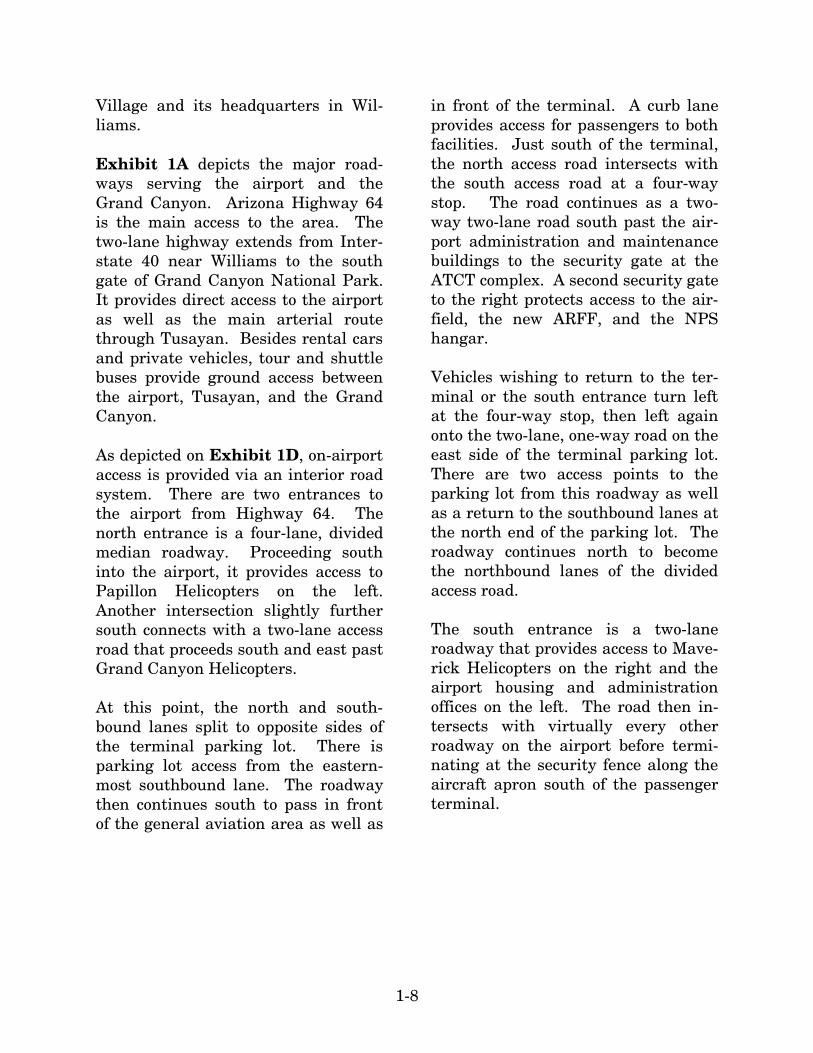
Village and its headquarters in Wil-liams. Exhibit 1A depicts the major road-ways serving the airport and the Grand Canyon. Arizona Highway 64 is the main access to the area. The two-lane highway extends from Inter-state 40 near Williams to the south gate of Grand Canyon National Park. It provides direct access to the airport as well as the main arterial route through Tusayan. Besides rental cars and private vehicles, tour and shuttle buses provide ground access between the airport, Tusayan, and the Grand Canyon. As depicted on Exhibit 1D, on-airport access is provided via an interior road system. There are two entrances to the airport from Highway 64. The north entrance is a four-lane, divided median roadway. Proceeding south into the airport, it provides access to Papillon Helicopters on the left. Another intersection slightly further south connects with a two-lane access road that proceeds south and east past Grand Canyon Helicopters. At this point, the north and south-bound lanes split to opposite sides of the terminal parking lot. There is parking lot access from the eastern-most southbound lane. The roadway then continues south to pass in front of the general aviation area as well as
in front of the terminal. A curb lane provides access for passengers to both facilities. Just south of the terminal, the north access road intersects with the south access road at a four-way stop. The road continues as a two-way two-lane road south past the air-port administration and maintenance buildings to the security gate at the ATCT complex. A second security gate to the right protects access to the air-field, the new ARFF, and the NPS hangar. Vehicles wishing to return to the ter-minal or the south entrance turn left at the four-way stop, then left again onto the two-lane, one-way road on the east side of the terminal parking lot. There are two access points to the parking lot from this roadway as well as a return to the southbound lanes at the north end of the parking lot. The roadway continues north to become the northbound lanes of the divided access road. The south entrance is a two-lane roadway that provides access to Mave-rick Helicopters on the right and the airport housing and administration offices on the left. The road then in-tersects with virtually every other roadway on the airport before termi-nating at the security fence along the aircraft apron south of the passenger terminal.