Embed Size (px)
Citation preview

Graham Stickler Esri Ocean GIS Forum,
Redlands, CA, 5-7 November 2013

Imagine …………………………..
A world with no horizons

Coastal Coverage

Space View

Satellite Constellation
• 6 satellite polar orbiting + 1 equatorial constellation • Currently 5 satellites in service • 2014: Full deployment(7 sats) • Provides rapid update rate at
higher latitudes • Satellite to be launched to
cover the equatorial band
• Provides full global coverage with rapid update rate • Now: 8-12 reports per day • 2014: 20-30 reports per day

Automatic Identification System (AIS)
Courtesy SRT

Operational Service
Currently processing 5,000,000 messages per day from over 100,000 ships

And we’ve been doing this for over 3 years!!!
……….. That’s a lot of data (0.5 billion
AIS messages) ………..
And a huge amount of important information!
(>300 million vessel positions)

Needles in the Haystack

S-AIS Playing a key role to Support African Maritime Security
Sponsored by U.S. Navy Sixth Fleet and managed by SPAWAR Systems Center (SSC) African Maritime Outreach Project: Integration of exactEarth Satellite AIS data into a web-based Common Operating Picture (COP) for use by participating African partner nations.
Cameroon, Cape Verde, Djibouti, Gabon, Kenya, Liberia, Mauritania, Mauritius, Morocco, Mozambique, Nigeria, Sao Tome & Principe, Senegal, Seychelles, Sierra Leone, Somalia, Tanzania, The Gambia

Anti-Piracy Applications
MT Motivator
S-AIS is an important tool in fighting the war against piracy • Wide area vessel traffic monitoring to protect commercial shipping • NATO (Northwood, UK) is the lead center for coordinating the
EU’s activities for Anti Piracy Operations and uses the exactAIS data service

Examples of Security Operations Op Podium
• 2010 Vancouver Olympics
• Long Range Surveillance
• Fill in gaps from other sensors
• Provide redundancy
FIFA World Cup
• 2010 South Africa
- Enhanced security planning

Search & Rescue • Search & Rescue Applications
• Independent verification of ship location
• Assist with ambiguity resolution
• Identification of ships in vicinity
• Last know position with tracks

Casualty Alerting

AIS Sensor Fusion Aids Oil Spill Investigation
Ship Identification
Data
Radar Imagery
• Merges data streams
• Provides identification information
• MMSI, IMO, name and type
• Positional Validation
• Cross reference with radar position
• Navigational data
• Course and speed
• Facilitates identification of ships of interest
Copyright © Canadian Space Agency and MDA
MMSI: 891212312 Name: Peregrine Falcon
MMSI: 891212376 Name: Millenium Falcon
MMSI: 989889981 Name: Seaborne Falcon
MMSI: UNKNOWN Name: UNKNOWN
MMSI: 129012659 Name: Maltese Falcon

Additional Applications
Emissions Monitoring
Regulatory Compliance
Radar Fusion
Behavioural Analysis

Spatial Analysis

Archive - July 2013

Nordic Orion
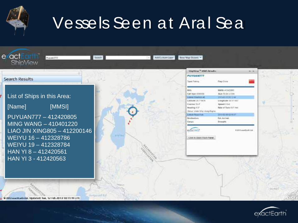
Vessels Seen at Aral Sea
List of Ships in this Area:
[Name] [MMSI]
PUYUAN777 – 412420805 MING WANG – 410401220 LIAO JIN XING805 – 412200146 WEIYU 16 – 412328786 WEIYU 19 – 412328784 HAN YI 8 – 412420561 HAN YI 3 - 412420563

Tracks, Nov 2012 – Feb 2013

Adjusting Latitude & Longitude
Prime Meridian (0° Longitude)
Equator (0° Latitude) Reported Track
Estimated Track Estimated Position
Reported Position

Vessels near Argentina EEZ

Positional Verification Analysis

exactEarth Streaming
Feed
exactEarth Web
Services
Attribute Filter
GeoFence Filter
Unfiltered GeoEvents
ArcGIS Online
web socket
Connector
Connector
Esri ArcGIS Server
GeoEvent Processor
Copyright ©2013 exactEarth Ltd. Unauthorized duplication or distribution is strictly prohibited. Permission to use, copy, and distribute is subject to exactEarth Ltd. prior written consent. Trademarks belong to their respective owners. All rights reserved
Delivery via GeoEvent Processor
ESRI Map API
ESRI ArcMap
email alert

AIS Data Stream
• In this example we see Esri GeoEvent Processor populating an area of the Ocean with ship positions
and information as the data is streamed from exactEarth. The filter being used here is a simple area
filter.

AIS Data Alerting
• In this example the service is started with a set of ships stored as a ‘watch list’. Esri GeoEvent Processor analyses
the stream and alerts the user when a new position report is received for a ship on the ‘watch list’. In this case the
Cosco Boston triggers the alert.

AIS Data Tracking
• Here again we track the Cosco Boston. In this case we are only interested in position reports from this one ship
from the streaming feed and we use this to provide a ‘live’ picture of its progress off the West Coast of the US after
passing through the Panama Canal. For illustration purposes the data feed is accelerated in this example.

exactAIS on ArcGIS Online
http://exactais.maps.arcgis.com/home/

Sample Data to view or download

ArcGIS Online

GeoEvent Processor for Server

www.shipmaps.com

“One day said Galileo a man will reach the sky
and see the world completely from outside.
And gazing down from yonder on a world of blue and green, he’ll say with eyes of wonder
I have seen. I have seen. My eyes have seen”
Discovery. Chris De Burgh

Thank You!
exactEarth is a data services company leading the way in delivering global maritime vessel information. Combining data from our exactView™ constellation of satellites with ground-based sources we collect and deliver the highest quality ship movement information to customers around the world.
Graham Stickler [email protected]
www.exactearth.com