Embed Size (px)
Citation preview
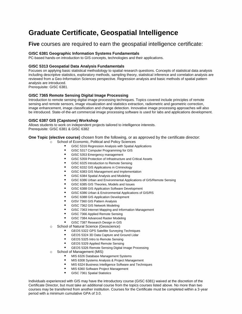
Graduate Certificate, Geospatial Intelligence
Five courses are required to earn the geospatial intelligence certificate:
GISC 6381 Geographic Information Systems Fundamentals PC-based hands-on introduction to GIS concepts, technologies and their applications.
GISC 5313 Geospatial Data Analysis Fundamentals Focuses on applying basic statistical methodology to spatial research questions. Concepts of statistical data analysis including descriptive statistics, exploratory methods, sampling theory, statistical inference and correlation analysis are reviewed from a Geo-Information Sciences perspective. Regression analysis and basic methods of spatial pattern analysis are introduced. Prerequisite: GISC 6381.
GISC 7365 Remote Sensing Digital Image Processing Introduction to remote sensing digital image processing techniques. Topics covered include principles of remote sensing and remote sensors, image visualization and statistics extraction, radiometric and geometric correction, image enhancement, image classification and change detection. Innovative image processing approaches will also be introduced. State-of-the-art commercial image processing software is used for labs and applications development.
GISC 6387 GIS (Capstone) Workshop Allows students to work on independent projects tailored to intelligence interests. Prerequisite: GISC 6381 & GISC 6382
One Topic (elective course) chosen from the following, or as approved by the certificate director: o School of Economic, Political and Policy Sciences
GISC 5316 Regression Analysis with Spatial Applications
GISC 5317 Computer Programming for GIS
GISC 5353 Emergency management
GISC 5359 Protection of Infrastructure and Critical Assets
GISC 6325 Introduction to Remote Sensing
GISC 6332 GIS Applications in Criminology
GISC 6383 GIS Management and Implementation
GISC 6384 Spatial Analysis and Modeling
GISC 6386 Urban and Environmental Applications of GIS/Remote Sensing
GISC 6385 GIS Theories, Models and Issues
GISC 6388 GIS Application Software Development
GISC 6386 Urban & Environmental Applications of GIS/RS
GISC 6388 GIS Application Development
GISV 7360 GIS Pattern Analysis
GISC 7362 GIS Network Modeling
GISC 7363 Internet Mapping and Information Management
GISC 7366 Applied Remote Sensing
GISC 7384 Advanced Raster Modeling
GISC 7387 Research Design in GIS
o School of Natural Science (Geoscience)
GEOS 5322 GPS Satellite Surveying Techniques
GEOS 5324 3D Data Capture and Ground Lidar
GEOS 5325 Intro to Remote Sensing
GEOS 5329 Applied Remote Sensing
GEOS 5326 Remote Sensing Digital Image Processing
o School of Management (MIS)
MIS 6326 Database Management Systems
MIS 6308 Systems Analysis & Project Management
MIS 6324 Business Intelligence Software and Techniques
MIS 6360 Software Project Management
GISC 7361 Spatial Statistics
Individuals experienced with GIS may have the introductory course (GISC 6381) waived at the discretion of the Certificate Director, but must take an additional course from the topics courses listed above. No more than two courses may be transferred from another institution. Courses for the Certificate must be completed within a 3-year period with a minimum cumulative GPA of 3.0.