Embed Size (px)
Citation preview

Revised Dmiw- Gradient Groundwater Assessment Work Plan Fountain -Vine Plaza, 1253 Vine Street, Los Angeles, California 90028 Jemmy 21, 2014
Page 3
L A thorough, very meticulous survey of subsurface utilities to ensure clear locations for borings. 2. Because the property is paved with concrete with possible rebar or wire mesh, the cost of geophysical
exploration would be expensive. 3. Air- latifing every bore hole location to a. minimal depth of 10 feet. Air -knifing is expensive and access
would be very difficult necessitating the use of specialized equipment. 4. Conducting extensive outreach, to the tenants. The tenants were represented as being highly engaged in
the management of the property, which would thus necessitate a fairly extensive and detail -oriented outreach with the tenants.
5. Noise reduction measures would need to be undertaken as a part of the well installation work in the central courtyard area given that the courtyard acts as an amplifier of noise.
6. Extraordinary flume reduction measures may also be necessary in light of the fact that the courtyard is enclosed.
The alternative location in the north alley /pathway area was therefore more closely scrutinized with the cooperation and expressed willingness of the Apartmeht Owner to attempt to accommodate that location in whatever way possible. AA&A thus discussed the new proposed location with I Ir. Jones of the LARWQCB and Dr Anilanantham of Geosyntec, and has determined that installing the wells in the north alley /pathway of the Villa Elaine property is feasible. In particular, it appears that a small limited -access drill rig, which is diesel - powered and self -contained can be safely operated in the north alley/pathway. Further, with the cooperation of the Apartment Owner, access to the north alley /pathway can be gained from either the eastern entrance of the alley /pathway from Vine Street or from the western entrance at the rear of the property.
As noted, some measures will have to be undertaken to allow for the access of the drill dg such as temporarily removing a floor- mounted A/C unit, removing the door and door frame at the eastern entrance, building a. ramp to transition front a step -down at the western entrance of the alley /pathway and removing a chain -link fence at the western end of the property. However, these measures can reasonably be implemented and Villa. Elaine has indicated that they would cooperate in implementing these measures.
Photographs of the Villa Elaine property which includes photographs of the north alley /pathway are provided as Attachment D.
In a meeting on January14, 2014, between Dr. Lee of the LARWQCB and Dr. Arulanantham of Geosyntec, the number of wells, their locations and the objectives of this Revised Work Plan, as described below, were all discussed and agreed to. Similarly, the decision on closure of the site and the issuing of a. no Thither action letters as further described below, based on the results of the sampling proposed in this Revised Work Plan, were discussed and seed to.
RATIONALE
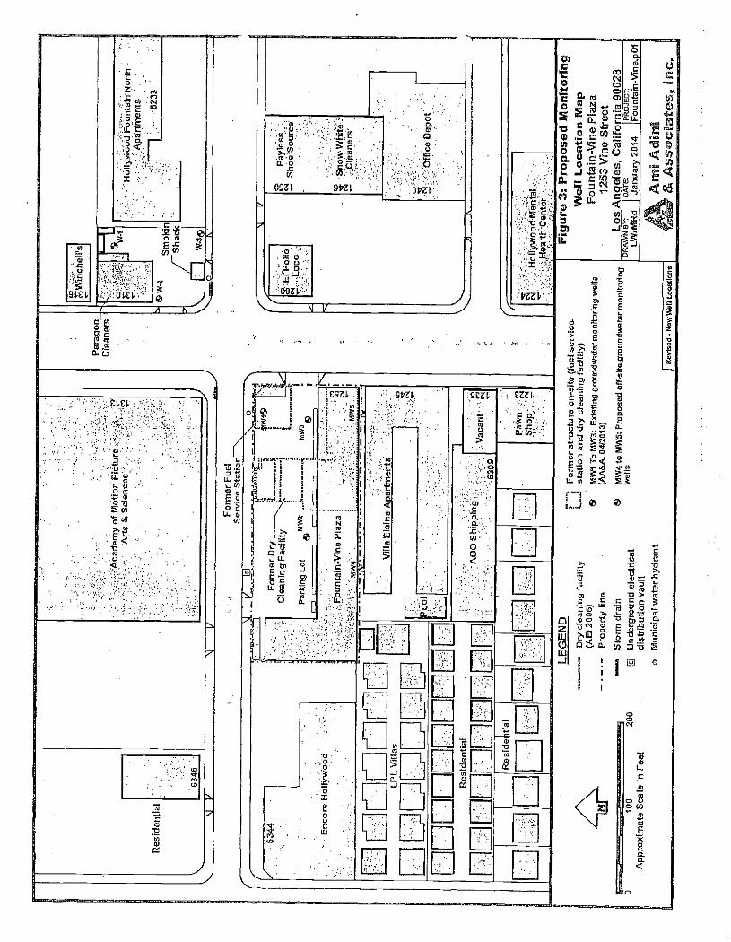
During a meeting conducted on October 16, 2013, at the offices of the LARWQCB attended by Messrs. Ami Adini and Matthew deHaas of AA&A, Ravi Arulanautham of Geosyntec, and Messrs. ICwans il Lee and Henry Tones of the LARWQCB and a subsequent site walk conducted ou October 17, 2013, (attended by Messrs. Ravi Arulanantham of Geosyntec, Matthew deHaas of AA&A, and Mr. Henry Jones of the LARWQCB) three groundwater monitoring well locations were selected and presented in a. work plan (dated December 9, 2013) to the LARWQCB. The LARWQCB approved that pròposal on December 18, 2013. However, as explained above because of the access issues and serious concerns expressed by the owner of the Villa Elaine Apartments property, in a meeting on January 14, 2014 between Dr. Kwang -Il Lee and Mr. Ravi Arulaiantham LARWQCB staff agreed that the Fountain-Vine property owner now need only install two wells, MW4 and MW5 as shown in Figures 2 and 3. The purpose of MW4 is to look for PCE and compare the concentration to MW2. The only purpose of MW5 is to look for PCE and compare the concentration to the levels found at the up- gradient Paragon

Revised Down-Gradient Groundhvater Assessment Work Plan Fountain-Vine Pia:0,1253 Vine Street, Los Angeles, California 90028 Januarn 21, 2014
Page 4
Cleaners site and for the LARWQCB staff to make future cleanup decisions regarding the Paragon Cleaners site. The newly proposed MW5 well location is not believed to be down- gradient from the Fountain-Vine site, and for this reason, the sampling results from this proposed well will not affect any decision on closure or the issuance of a. "No Further Action" or "NFA" letter involving the Fountain -Vine site. The location of proposed well MW4 is believed to be generally down- gradient from MW2 (presently located on the Fountain -Vine site).
During the January 14th meeting between Dr. Kwang -il Lee and Mr. Ravi Arulanantham it was conceptually agreed that if the PCE concentrations in MW4 are not any significantly higher than the current concentrations found in 1MIW2, the LARWQCB will consider that the Fountain -Vine Plaza site is not a continuous source of PCE to the groundwater found under and in the immediate vicinity of the Fountain -Vine Plaza site or adjacent properties and will therefore then issue an NFA letter to the Fountain -Vine Plaza property owner for that property.
OBJECTIVE
The objective of the work proposed herein is to provide still further evidence that the subject site has not contributed sufficiently appréciable levels of PCE to the groundwater under and in the immediate vicinity of the site or adjacent properties, so as to justify the need for any further assessment or cleanup action on the Fountain- Vine site. lu addition to PCE, AA &A also intends to verify that no total petroleum hydrocarbons as gasoline (TPHg) from historical site uses have impacted groundwater beneath the site or adjacent properties.
Further, it is understood that the LARWQCB will recognize the site as a non -contributor and issue anNFA letter for the site to the owner, if PCh concentrations in groundwater samples collected from the proposed off -site well identified as lvtW4 do not exhibit appreciably higher concentrations of PCE than in the up- gradient groundwater beneath the site as encountered in MW2.
With these objectives in mind, two soil borings at the locations agreed to with LARWQCB staff (revised Figure 3) will be advanced off -site in the north alley /pathway located at the northern boundary of the Villa Elaine apartment complex.
Additionally, the two soil borings will be converted into groundwater monitoring wells and subsequently sampled in conjunction with all site wells and all wells located at the up- gradient Paragon Cleaners site.
AA &A will provide data to accomplish the following:
1. Provide current -clay groundwater samples from the site to supplement previous assessment data.
2. Eliminate all Iateral- extent data gaps remaining fromprevious assessments, primarily in the off -site, down- gradient direction.
3. Provide comparable groundwater analytical data between the Fountain -Vine Plaza and Paragon Cleaners sites.
4. Provide a present -time groundwater PCE plume map for the Paragon Cleaners site based on available data.

Revised Down -Gradient Groundwater Assessment Work Finn Fountain -Vine Plaza, 1253 Vine Street, Los Angeles, California 90028 January 21, 2014
Page 5
SCOPE OF WORK The scope of work for this environmental site assessment includes the following:
Advance two off -site, hollow -stem auger borings from grade to approximately 45 feet below ground surface (bgs) as shown on revised Figure 3. Soil samples will be collected from each of the borings at 5- foot intervals for lithologìc evaluation and field screening of volatile organic compounds (VOCs) using a photo -ionization detector (PID) calibrated to a.100 parts per million (ppm) isobutylene standard, No soil samples will be submitted for laboratory analysis.
Prior to initiating field activities, AA&A will update the community health and safety plan (HSP) for the proposed activities. The HSP will be reviewed by all parties involved in the completion of daily tasks prior to the start of work each day.
Completion of the borings as groundwater monitoring wells identified as MW4. and IvIWS. The locations of the wells Were selected to identify groundwater conditions in the dawn -gradient direction of the former dry cleaning equipment located on the Fountain -Vine Plaza site as well as conditions down -gradient of the Paragon Cleaners site.
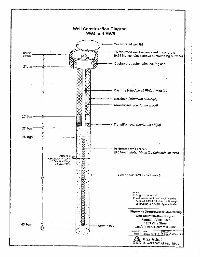
Construction of the wells using 1 -inch diameter, schedule 40, perforated PVC screen and blank well materials. The screened intervals of the wells will extend from approximately 25 to 45 feet bgs. A proposed well construction diagram is provided as Figure 4.
Development of the new wells a minimum 72 hours after installation to improve the hydraulic communication between the geologic formation and the well by removing suspended solids. Well development will be completed using a surge block and bailer or submersible pump. Well development will be continued until the following is achieved:
o Up to five well volumes of fluids are exh'acted from each well; o The temperature, pH, conductivity, and turbidity of the removed water has stabilized; and o Suspended solids have been removed so that the water is clear of cloudiness or turbidity (visual
observation), and the silt buildup at the bottom of the wells has been removed. The total well depth will be measured during well development to monitor the removal of silt buildup.
The elevations of the newly Stalled g oundwater monitoring wells will be surveyed relative to the known benchmark by a. California- licensed laud surveying company. The top of the well casings, cover of the wells, and the ground surface will be measured in feet relative to the North American Vertical Datum of 1988.
AA&A will conduct joint monitoring with the Paragon Cleaners site and utilize wells associated with both sites. Groundwater mònitoring will be conducted in general accordance with AA &A's Standard Operating Procedure for groundwater monitoring provided as an attachment to this work plan. Groundwater samples will be collected using bottom -fill, factory- sealed, disposable polyethylene bailers (one per well). Groundwater samples will be analyzed by EPA Methods 8260B for full scan VOCs and 8015M for TPHg.
Prepare a report detailing the activities and results of the investigation.
te IL
Revised Doi 72- Gradient GroundiraterAssessment Work Plan Fountain -Vine Plaza, 1253 Vine Street, Las Angeles, California 90028 Jainraa3' 21, 2014
Page 6
The work will be completed under the supervision of a Professional Geologist (PG) licensed in California in compliance with the requirements of the Geologist and Geophysicists Act, Business and Professions Code sections 7800 -7887.
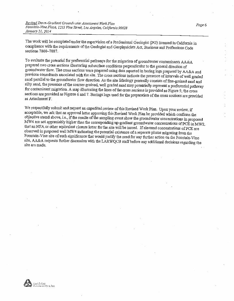
To evaluate the potential for preferential pathways for the migration of groundwater contaminants AA&A prepared two cross sections illustrating subsurface conditions perpendicular to the general direction of groundwater flow. The cross sections were prepared using data reported in boring logs prepared by AA &A and previous consultants associated with the site. The cross sections indicate the presence of intervals of well graded sand parallel to the groundwater flow direction. As the site lithology generally consists of fine- grained sand and silty sand, the presence of the coarser - gained, well graded sand may potentially represent a preferential pathway for contaminant migration. A map illustrating the lines of the cross sections is provided as Figure 5; the cross sections are provided as Figures 6 and 7. Borings logs used for the preparation of the cross sections are provided as Attachment F.
We respectfully submit and request an expedited review of this Revised Work Plan. Upon your review, if acceptable, we ask that an approval Ietter approving this Revised Work Plan be provided which confirms the objective stated above, i.e., if the results of the sampling event show the groundwater concentrations in proposed MW4 are not appreciably higher than the corresponding up- gradient groundwater concentrations of PCE in MW2, that an NFA or other equivalent closure letter for the site will be issued. If elevated concentrations of PCE are observed in proposed well MW4 indicating the potential existence of a separate plume migrating from the Fountain -Vine site of such significance that would justify the need for any further action on the Fountain -Vine site, AA &A requests further discussion with the LARWQCB staff before any additional decisions regarding the site are made.

Revised Down- Gradient Groundwater Assessment Work Plan Fountain-Vine Plaza, 1253 Vane Street, Los Angeles, California 90028 Janumy 21, 2014
Page 7
If you have any questions, please contact us at (818) 824 -8102.
Respectfully submitted,
AMI ADINI &. ASSOCIATES, INC.
This Revised Down -Gradient Groundwater Assessment Work Plan has been prepared by
Matthew R deHaas, PG Senior Geologist Professional Geologist No. 8535, Expiration Date 11/30/14
under the professional review and quality control of
Gabriele Baader PG Director of Environmental Engineering Professional Geologist No. 7015, Expiration Date 4/30/14
and approved by Ami Adirai President, Principal Environmental Consultant NREP Registered Environmental Professional No. 2614 General Engineering /Hazardous Waste Contractor No. 587540 B. Sc. Meek. Eng. GS:mrd/Iw
cc: Addressee (PDF) Mr. Cart Van Quathem (PDF)
MATTHEW R, deHAAS
N0. 8535 EV. NOV. 30, 2014
GABRIELE E. BAADER
NO. 7015 D(P. APR. 30, 2014
Revised Down- Gradient GroanndirateAssessment Work Plan Fountain-Vine Plagia, 1253 Vina Street, Los Angeles, California 90025 January 21, 2014
Page 8
Attachments:
Attachment A: Figures 1 through 7
Figure 1- Site Vicinity Map Figure 2 - Site Map with PCE Plume in Groundwater Figure 3 - Proposed Monitoring Well Location Map Figure 4 -Well Construction Diagram Figure 5 -Site Map with Lines of Cross Section Figure 6 - Cross Section E-E' Flame 7- Cross Section F -F' Figure 8 - PCE Concentrations in Groundwater
Attachment B: LARWQCB Correspondence dated December 18, 2013 Attachment C: Villa Elaine Apartment Owner Access Ag reerPnt Denial, Dated October 24, 2013 Attachment D: Photographic Logs Attachment E: Groundwater Monitoring Standard Operating Procedure Attachment F: Baring Logs
;}; a<s ,, .;a, ._ ::,i<-.n,<..

Revised Douro- Gradiert GronnndieaterAssessment Work Plan Fountain -Vine Plow, 1253 Vine Street, Los Angeles, California 90028 Jaananq 21, 2014
ATTACHMENT A
Figures 1 through 7
6 ..,, ,_..

- S Stana 8i tl
fl
t! ade,teln t ,a
I I
i9 a
igaantrAre_ t. _ _ _ilNigazndPve_. ,
`a.
a - , , hll.a area ir, e v4a Err e5A-y
Jr, ei
m m t m n
m v J ÌI
l C. 44 81.1

PC
E
Con
cent
ratio
ns
in p
a&
43.
14#
417,
2.00
0
1.09
0
o
6346
-
Aca
dem
y of
Mel
len
Pic
ture
.
;-1-
1e-L
S:&
.Scl
ence
s
For
mer
Fue
l S
ervi
ce S
tati.
V
....
1=1
For
mer
Dry
C
lean
ing
Fac
ility
,'
Par
king
Lot
/s
r,
IS
1500
'
Win
chel
's
ti.ily
WO
od F
ourt
ainf
iofth
A
part
men
ts
6233
°k
in
eck
Enc
ore
.Ho
fyw
ood
EIM
EC
EI
LPL
Od
oò
7117
171F
EI7
r177
E
Res
iden
t 7
Res
iden
tial
-V Il
th
E
A-i
ni
pin
100
App
roxi
mat
e S
cale
in
Fee
t
LEG
EN
D
Dry
cle
anin
g fa
cilit
y (A
EI
2006
) P
rope
rty
line
Sto
rm d
rain
20
0 O
U
nder
grou
nd e
lect
rical
di
strib
utio
n va
ult
o M
unic
ipal
wat
er h
ydra
nt
Hol
lyw
ood
Men
taiL
F.-
tf .;H
ealth
9er
iter.
;[°-:
,,z."
.
For
mer
str
uctu
re o
n-si
te (
fuel
ser
vice
st
atio
n an
d dr
y cl
eani
ng fa
cilit
y)
S
MW
1 T
o M
w;
Exi
stin
g gr
ound
wat
erm
onito
rIng
wel
ls
(AA
&A
, 04/
2013
)
MW
4 to
MW
5: P
ropo
sed
off-
site
gro
undw
ater
mon
itorin
g w
ells
6,16
0 P
CE
Con
cent
ratio
n In
gro
undw
ater
in m
icro
gram
s pe
r lit
er (
pgtL
) R
evis
ed -
New
Wel
l L
ocat
ions
Fig
ure
2: S
ite M
ap w
ith P
CE
P
lum
e in
Gro
undw
ater
- 4/
16/1
3 F
ount
ain-
Vin
e P
laza
12
53 V
ine
Str
eet
Los
Ang
eles
, C
alifo
rnia
900
28
DR
AW
N B
Y:
DA
TE
: P
RO
JEC
T:
LWJM
Rd
Janu
ary
2014
F
ount
ain-
Vin
e.p0
1]
Am
i A
di rt
i A
kv &
A
ssoc
iate
s °
Res
iden
tial
6346
V
V
Aca
dem
y of
Mot
ion
Pic
ture
. ..'
Art
s &
- Sci
ence
s` -°
M
V
V
For
mer
Fue
l S
ervi
ce S
tatio
n V
.
u
6344
.
Enc
ore
Hol
lyw
ood
-"ë
Ike!
? F
orm
er D
ry
E
Cle
anin
g F
acili
ty
' ° '
¡ --
2G
Par
king
Lot
N
mw
z .-
" " -
" n
`
!.Fou
ntai
n -V
ine
Pla
za
am('
nnE
iGn
DiE
tuD
nonnnn:nno
Res
iden
tial n
I I
Res
iden
tial
I I
m
MW
3
Vill
a E
lain
e A
part
men
t
AO
O S
hipp
ing'
!:;
6309
V
acar
rt..-
; Kt'
Pawn
: "
Shp
pe .
.
Par
agon
C
lean
ers
árlti
Rnc
hel's
SW
tD
Sm
o k
in
Sha
ck
W -3
t9
e'
`Hál
lyw
äod
Foú
ntai
n N
orth
-
7
Apa
rtm
ents
l(yw
àód-
Mëñ
tal-,
- .=
:,Heá
M6.
Cer
itër-
__.._
:,
0
100
App
roxi
mat
e S
cale
in
Fee
t
LE
GE
ND
r-
1 F
orm
ers
rect
are
on -s
ite (
fuel
ser
vice
F
igur
e 3:
Pro
pose
d M
onito
ring
,m..n
. =
Dry
cle
anin
g fa
cilit
y st
atio
n an
d dr
y cl
eani
ng f
acili
ty)
Wel
l Lo
catio
n M
ap
(AE
I 200
6)
S
MW
7 T
o M
W3:
E
xist
ing
grou
ndw
ater
mon
itorin
g w
elts
Fo
unta
in -V
ine
Plaz
a - -
--
Pro
pe r
fy l
ine
(AA
&A
, 04
/201
3)
1253
Vin
e St
reet
®
Sto
rm d
rain
S
M
W4
to M
W5:
Pro
pose
d of
f-si
te g
roun
dwat
er m
onit
ring
Los
Ang
eles
C
alif
orni
a 90
028
El
DR
AW
NB
Y:
OR
TE
P
RO
JEC
T:
LW /M
Rd
Janu
ary
2014
F
ount
ain-
Vin
e.p0
U
nder
grou
nd e
lect
rical
w
ells
20
0
o di
strib
utio
n va
ult
Mun
icip
al w
ater
hyd
rant
A
mi A
dhü
gaire
zr &
Ass
ocia
tes,
Inc
. R
evis
ed -
Na w
WeI
I Lo
catio
ns
Ground Surface
2' bgs
T
Well Construction Diagram MW4 and MW5
Traffic-rated well lid
"`{) Traffic -rated well box encased in concrete ] (0.25 inches raised above surrounding surface)
Ints, 141'
18'
20' bgs
23' bgs
25' bgs
45' bgs
20'
Fllstorioal Groundwater Level
(28.5e 29,43' bgs -AA &A 2013)
0.5'
Casing protrusion with locking cap
Casing (Schedule 40 PVC, 1 -inch 0 )
Borehole (minimum 5- lnchfö)
Annular seal (bentonite grout)
Transition seal (bentonite chips)
Perforated well screen (0,01 -inch slots, 1 -inch , Schedule 40 PVC)
Bottom cap
Alter pack ( #2/12 silica sand)
Notes: 1. Diagram not to scale, 2. Well screen depth and length may be
adjusted in the field based on lithologie observation and depth of groundwater.
Figure 4: Groundwater Monitoring Well Construction Diagram
Fountain -Vine Plaza 1253 Vine Street
Los Angeles, California 90028 DRAWN BY:
MRd DATE:
January 2014 PROJECT; Fountain- Vine,p01
XAmi Adioti & Associates, Inc,

Aca
dem
y of
Mot
ion
Pic
ture
A
rts
& S
cien
ces
n
For
mer
Dry
F
orm
er F
uel
Cle
anin
g F
acili
ty
by A
EI
2006
(7)
\ rvice Statio
n
V-_
-_._
-_-_
-_._
-_-_
AE
I-86
.
AF
J87f
- 0
3 ®
820
Ahl
-B60
t[i23
F
orm
er D
ry
Cle
anin
g F
acili
ty
(San
born
195
7)
I88w
A
EI8
1 -
4a;A
EI-
B12
e O
=
. a
' Ê
l-BY
-.
-21
MW
ru
ae
33
6220
-. -
83i:
AE
I-61
80
-"T
I
,CJ/
11
i 52
8 -B
4 I G
o A
EI-
6AE
I9
1
AE
I-67
1 `
te-o
2
B 5
0828
0
529
AE
I -81
30
®08
30
Par
agon
C
lean
ers
Win
che
f I's
P
CE
Sto
rage
C
onta
iner
,, p F
ount
äin-
Vin
é P
läza
,Víll
á=E
láiin
è A
pe rt
in.
is.
OA
El8
1$
AE
I -B
16
e
Sm
okin
' S
hack
0 A
EI-
1317
:: H
olljl
wóo
d_F
ount
ain
= K
órth
Äpa
r6ne
nts 62
3
V
o.
EI
Pol
lo
ñ
.
Loco
Sno
w W
hite
C
lean
ers
Pay
less
S
hale
. Sou
rce
Offi
çè--
Dep
ot
75
App
roxi
mat
e S
cale
in F
eet
150
LEG
EN
D
Pro
pert
y lin
e D
ry c
lean
ing
faci
lity
(AE
I 20
06)
v S
torm
dra
in
©
Und
ergr
ound
ele
ctric
al
dist
ribut
ion
vaul
t o
Mun
icip
al w
ater
hyd
rant
" - -t
F
orm
er s
truc
ture
on
-site
(f
uel
serv
ice
stat
ion
and
dry
clea
ning
fac
ility
)
sz0
-133
3 O
S
oil,
solig
as,
and-
grou
ndw
ater
bor
ings
(A
A &
A,
0412
013)
M
w1
-MW
3 6;
7 G
roun
dwat
er m
onito
ring
wel
ls
F
r C
ross
Sec
tion
Fig
ure
5: S
ite M
ap w
ith L
ines
of
Cro
ss S
ectio
ns
Fou
ntai
n -V
ine
Pla
za
1253
Vin
e S
tree
t Lo
s A
ngel
es,
Cal
iforn
ia 9
0028
D
RA
WN
8Y
: D
AT
E:
PRO
JEC
T:
MR
d N
ovem
ber
2013
F
ount
aln-
Vin
e.p0
1
AX
Am
i A
dirs
i &
Ass
ocia
tes;
inc
.

E)
a
Æ 0
/
o
c. to

AE
I-B
B
AE
-ea
B21
B
31
B
AE
I -B
IO
lUT
PÁE
I _I
I SM
s 0
SM
SM
SP
ICA
SP
$Wo a
l. ä°
ei
r4.y
SP
SM
ÿ --
.
- ú
? --n
:`
° -
vM>
a _
a 0 _ :0
w
rSV
m
m
r-__
,c
_4
_ ..
0Rn
=
SP
SM
SM
10
20
30
40
50
60
70
80
90
100
110
120
130
140
150
160
170
180
190
Dis
tanc
e (F
eet)
I
I
I
200
210
220
bori
ng
SP
(R
eedy
gra
ded
sand
)
SM
(S
ilty
sand
)
ML
(Sif
t)
LEG
EN
D
CL
(San
dy, S
ilty
clay
)
SW
(W
ell g
rade
d sa
nd)
Sj _
_ G
roun
dwat
er T
able
Fig
ure
7: C
ross
Fo
unta
in -V
in
1253
Vin
e L
os A
ngel
es, C
ali
RA
WN
B
r:
I D
AT
E
MR
d N
ovem
be
Ant
i A
dii
v &
Ass
oc
Revised Down-Gradient Grounthvate' Assessment Work Plan Fountain -Vine Plaza, 1253 Vine Sheet, Los Angeles, California 90028 January 21, 1014
ATTACHMENT B
LARWQCB Correspondence dated December 18, 2013
VrEr`'
o o n NrG
Water Boards
Y.i Enemm 0. EnOOm Jn, ovemron
MuremMpnrou2 márrom rñ°: nmmEmrua
Los Angeles Regional Water Quality Control Board
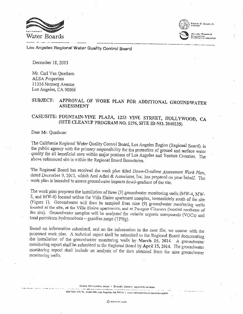
December 18, 2.013
Mr, Carl Van Quathem ALSA Properties 1 1356 Nutmeg Avenue Los Angeles, CA 90066
SUBJECT: APPROVAL OF WORK PLAN FOR ADDITIONAL GROUNDWATER ASSESSMENT
CASE /SITE: FOUNTAIN -VINE PLAZA, 1253 VINE STREET, HOLLYWOOD, CA (SITE CLEANUP PROGRAM NO. 1196, SITE ID NO.2040235)
Dear Mr, Quathem:
The California Regional Water Quality Control Board, Los Angeles Region (Regional Board), is the public agency with the primary responsibility for the protection of ground and surface water quality for all beneficial uses within major portions of Los Angeles and Ventura Counties. The above referenced site is within the Regional Board Boundaries.
The Regional Board has received the work plan titled Dawn -Gradient Assessment Work Plan, dated December 9, 2013, which Ami Adini & Associates, Inc. has prepared on your behalf. The work plan is intended to assess groundwater impacts down- gradient of the site.
The \work plan proposes the installation of three (3) groundwater monitoring wells (MW -4, MW- 5, and MW -ó) located within the Villa Elaine apartment complex, immediately south of the site (Figure 1). Groundwater will then be sampled from nine (9) groundwater monitoring wells located at the site, at the Villa Elaine apartments, and at Paragon Cleaners (located northeast of the site). Groundwater samples will be analyzed for volatile organic compounds (VOCs) and total petroleum hydrocarbons - gasoline range (TPHg).
Based on information submitted, and on the information in the case file, we concur with the proposed work plan. A technical report shall be submitted to the Regional Board documenting the installation of the groundwater monitoring wells' by March 15, 2014. A groundwater monitoring report shall be submitted to the Regional Board by April 15, 2014. The groundwater monitoring, report shall include an analysis of the data obtained from the nine groundwater monitoring wells.
MARIA WNRANV.N, CHAIR JCArr1uEL UNGER, EXECUTIVE OFFICER .. .... -._ ......_...._....._.__...__ . ..................... _.._.......... ... . _ ..
320 Warn itM1 St, suite 200, Los Angeles, CA 00013 t e,,+,awplemo::rtle0 {Iml;losanAetts
Cy nmC:mryc ronsn

Mr. Carl Van Quaihem ALSA Properties, Ltd.
December l8, 2013
If you have any questions regarding this project, please contact Mr. Henry Jones at (213) 576- 6697 or hjones @waterboatds.ca.gov
Sincerely,
Kwang -il Lee, PIS. D., Site Cleanup Program Unit IV Chief
Attachment: Figure 1, Proposed Monitoring Well Location Map
Electronic Copies: Mr. Ami Adirai, Ami Adivi & Associates (amia cr aniladini.com)
5 o t Q1L
Ñy 3
m
01784
V V
C9Z4
e
o o O.
a
EZZ4
á N
o

Revised Down- Gradient Groundwater Assessment Work Plan Fountain-Vine Plaza, 1253 Vine Street, Los Angeles, California 90028 Jana?), 21; 2014
ATTACHMENT ,C
Villa Elaine Apartment Owner Access Agreement Denial, Dated 10 -24 -2013
a

FAX
TO
AMI ADINI &ASSOCIATES, INC.
FAX #
1-818-824-8112
FAX
FROM
JULIE IONES PATTEN
PROPERTY MANAGER
VILLA ELAINE LP
FAX #
1- 818 -248 -6838

Acscss Aartement far 1245 North Vina Rhum, Hollywood, Cilia/mid 9ea38 Octobtr23.2013
ACCESS AGREEMENT ACCEPTANCE
This Av. COS Agreement Letter, dated October 23, 2013 has been received and review granted to ALCA Properties, Ltd and im consultants and subcontractors, in accordanc conduct the installation and sampling of three groundwater monitoring wells, as dead Ixated at 1245 Netth Vint Street in Hollywood, California,
Approved by
Signature;
Titte;
Date;
Page 4
approval is hereby the terms above, to beve, on the property
Revised Down-Gradient Groundwater Assessment Work Plan Fountain-Vine Pla_a, 1253 Vrne.Street, Los Angeles, California 90028 January 21, 2014
ATTACHMENT D
Photographic Logs

PHOTOGRAPH #C LOG Client Name: ALCA Properties, Ltd Photo No.c Date:
01/1012014 Direction Photo Taken:
W Description:
From main entrance off Vine Street look into courtyard..
Sate Location: Villa Elaine Apa
I Project No.: Photos Taken by: , 1245 Vine SL, Moll ood Fountain- Vine.P01 I Anil Mini
ç;

Client 11 le: ALDA Properties, Ltd. Photo No.: Date:
2 01(10/2014
PHOTOGRAPHIC LOG Site L ocati o n Project No.: I Photos Taken by: Villa Elaine Apartments, 1245 Vine St, Hollywood Fountain-Vine.P01 Ami Adini
Direction Photo Taken: West
Description:
View from main entrance off Vine Street look into courtyard.

PHOTOGRAPHIC LOG Client Name: ALGA Properties, Photo No.:
3 01/10l2014 Direction Photo Taken:
West Description:
From main entrance off
Vine Street look into courtyard..
Site Location: Villa Elaine Apartments, 1245 Vine St, Hoflywood
r
Project No.: Fountain -Vine P
Photos Taken by: i Adlni
PHOTOGRAPHIC LOG Client Name; ALCA Properties, Ltd. Photo No.: Date:
4 01/10/2014 Direction Photo Taken:
West ription:
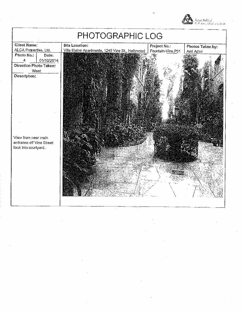
View from near main entrance off Vine Street look into courtyard..
Site Location: Project No.: Photos Taken by: Villa Elaine Apartments, 1245 Vine St, Hollywood l Fountain-Vine P01 I Ami Adini
s:

Client Name: ALCA Properties, Ltd
Photo No.: Date: 5 , 01/10/2014
Direction Photo Taken: West
Description:
PHOTOGRAPHIC LOG Site Location: Villa Elaine A nts, 1245 Vine St, Fi
Project No,: Fountain-Vine P0I
Photos Taken by: Ami Adini
lookin ide of court yard

Client Name' ALCA Prom erltes, Ltd.
PHOTOGRAPHIC LOG ite Location:
I Project No.:
g .11H
Photos Taken by: Vifla Elaine Apartments, 1245 Vine St., Holl cod Fountain-Vine P01 Ami Adini hoto No.: Date: 6 01/10/2014
Dir ction Photo Taken: West
Description;
Northside of court yard from middle portion looking west.
,
-1,[3 ' ».?
ft
_
, '
rr -1? 'L:17:;-; 4411.;
4--Cr. At- 445- -,-
.th , '-r

Client Name: ALCA Properties, Ltd. Photo No.: Date:
7 01/10/2014 Direction Photo Taken
West Description:
PHOTOGRAPHIC LOG Site Location: Villa Elaine Aartments, 1245 Vine St, Hal
Project No.: FountainVine
North side of court yard from middle portion looking west.

Client Name: ALCA Pr..ertlee Ltd Photo No.: Date:
8 01/10/2014 Direction Photo Taken:
West Description:
South side of court yard, back portion looking west.
PHOTOGRAPHIC LOG She Location: Villa Elaine artmen
Project No.: Photos Taken by: ood Fountain -Vine P01 Ami Adini

Client Na ALCA Pro +erties, Ltd.
Photo No Date: 9 01/10/2014
Direction Photo Taken" West
Description;
PHOTOGRAPHIC LOG Site Location: Villa Elaine . -rtments, 1245 Vine St , Hollywood
Project No.: Fountain-Vine P01
Photos Taken by: Ami Adini
North side of court yard, back portion looking west.

Client Name: ALCA Propertie Photo No.: Date:
10 01/10/2014 Direction Photo Taken;
West Descrip
North side of court yard, back portion looking west.
PHOTOGRAPHIC LOG Site Location: Project No.: Villa Elaine Apartments 1245 Vine St , Hollywood 1Fountain-Vine P01
+,
Photos Taken by: Ami Adini
r¡

Client Name: ALCA Properties Ltd. Photo No,: pat
11 01/10/2014 Direction Photo Taken:
West scription:
PHOTOGRAPHIC LOG ite Location:
Villa Elaine A ents, 1245 Vine SI Holl Project No.: Fountain -Vine PO
Photos Taken by: Ami Adinl
South side of court yard, back portion looking west.
r::z,`:rl_

Client Name: ALCA Properties, Ltd. Photo No.:
12
Date: 01/10/2014
Direction Photo Taken:
Description:
Northsïde of court yard, back portion looking west.
PHOTOGRAPHIC LOG Site Location: Villa Elaine Apartments, 1245 Vine St Holl ood Fountain- Vine.P01 Ami Adini
Project No.: Photos Taken by:
PHOTOGRAPHIC LOG Client Name: ALGA Properties, Ltd.
Photo No.: Date: 13 01/10/2014
Direction Photo Taken: West
Description:
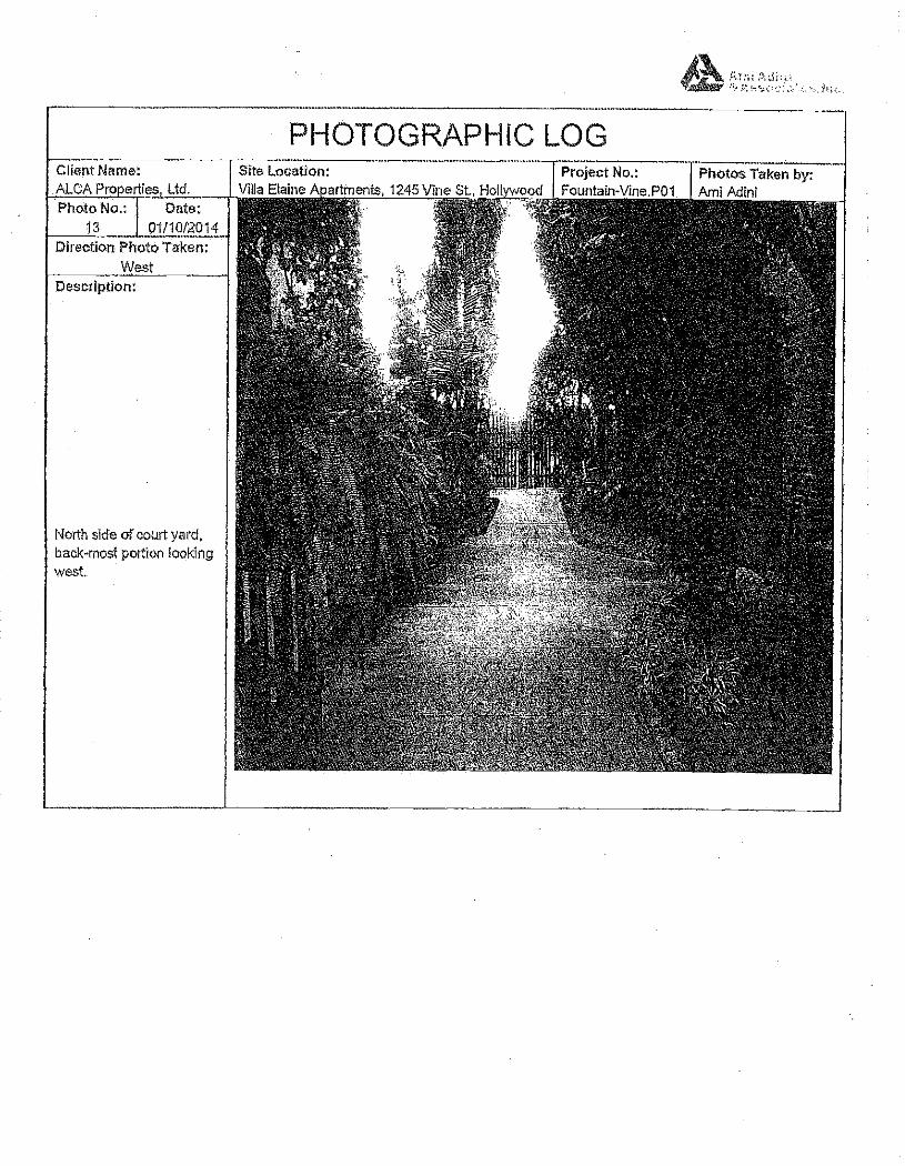
North side of court yard, back -most portion looking
ite Location: Project No,: Photos Taken by: Villa Elaine Aartments, 1245 Vine St, Hall ood Fountain -Vine P01 Ami Adini
PHOTOGRAPHIC LOG Client Name: Site Location* Project No.: I Photos Taken by: ALCA Pro .erìies, Ltd. Viffa Elaine Apartments, 1245 Vine St. Holl ood Fountain- Vine.P01 Ami Mini Photo No.:
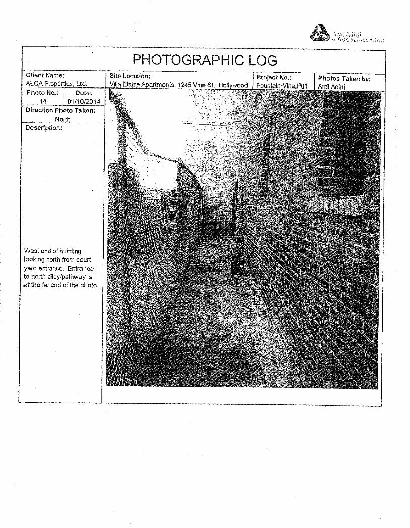
14 01/10/2014 Direction Photo Taken:
North Description:
West end of building looking north from court yard entrance. Entrance
north alley /pathway is
the far end of the photo_
"k666k's?.6,
PHOTOGRAPHIC LOG Client Name: Site Location: 1 Project No.:
1 Photos Taken by: ALCA Properties, Ltd. Villa Elaine Apartments, 1245 Vine St. Hell cod 1 Fountain-Vine.P01 I Arni Adinl
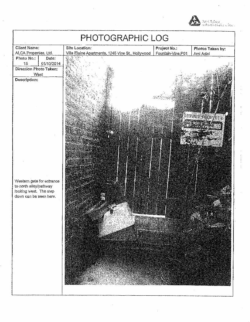
, . . Photo No: Date: \
t.
15 01/10/2014 k ' ,
Direction Photo Taken: r .c y-T.
... West - .i.-' ; ,T ' .
*
Description: ,,i , .., t e
16.: 6 ' st , , ssi '' '' ';'' l'
. , 6 rkl?' r
, s , ..
* ' 1 - C) h
h
Western gate for entrance to north alley/pathway looking west The step
down can be seen here,
flss
''/ItivArr :pi
Cht
I. r er-} '`h.71.

PHOTOGRAPHIC LOG. Client Name: ALCA Properties, Ltd, Photo No.: Date:
16 01/10/2014 Direction Photo Taken:
West Description:
View of north
alley/pathway looking west. Approximately 213
of the pathway can be
seen in the photo.
Site Location: Villa Elaine A artments, 1245 Vine St , Holl cod Fountain-Vine POI Ami Adini
Project No.: Photos Taken by:

PHOTOGRAPHIC LOG Client Name: ALCA Properties, Ltd.
Date: 01/10/2014
Direction Photo Taken: East
Photo No.: 17
Description:
View of north alley /pathway looking east from a point near the western gate..
Site Location: Project No.: Photos Taken by: Villa Elaine Apartments 1245 Vine St, Flo ll ood Fountain -Vine P01 Ami Mini

PHOTOGRAPHIC LOG
A Photo No
18
e Location: a Elaine A.artment
a
01/10/2014 Direction Photo Taken:
ae
View of north alleylpathway looking west from a point near the eastern entrance. The A/C units can be seen in this photo.
Project No.: Fountain Une P01
Photos Take Ami Adini
Y

PHOTOGRAPHIC LOG Client Name: ALCA Properties, Ltd. Photo No.: Date:
19 01/10/2014 Direction Photo Taken:
West Description:
View of north
alley/pathway looking west through the
door/entrance located off of Vine Street
Site Location: Photos Taken by: Villa Elaine Apartments 1245 Vine St, Holt ood Fountain-Vine.P01 j Ami Mini
'
n
I
' ' 1
IU I I
Ujf ' i .. Silliiii4411:" "44;4,,,,- 3-Iiii , it , . ' 4,' ,,tr,
4
tc,,, 41
-4-- ail ' ilipli l'it Hf
t t !

Revised Dawn-Gradient Groundwater Assessment Work Plan Fountain -Vine Plaza, 1253 Vine Street, Los Angeles, California 90028 Ja7711a11, 21, 2014
ATTACHMENT E
Groundwater Monitoring Standard Operating Procedure
ieri'lUl
A Adirti & Associates9 inc
Standard Operating Procedure: Water -Level Measurement
I. Scope and Application The objective of this Standard Operating Procedure (SOP) is to describe the procedure to measure and record grotmdwarer and surface-water elevations. Water levels may be measured using an electronic oil -water level indicator or a pressure transducer from established reference points (e.g., top of casing). Reference points will be surveyed to evaluate their elevations relative to mean sea level. This SOP describes the equipment, field procedures, materials, and documentation procedures necessary to measure and record &oundwater and surface -water elevations using the aforementioned equipment.
This is an SOP (i.e., typically applicable) that may be varied or modified as required, depending on site conditions, equipment limitations, or limitations imposed by the procedure. The ultimate procedure employed will be documented in an applicable monitoring report.
IL Personnel Qualifications Ami Adini & Associates, Inc. (AA&A), field sampling personnel will have current health and safety training including 40 -hour Hazardous Waste Operations and Emergency Response (HAZWOPER) training, site supervisor training, site- specific training, first aid, and cardiopulmonary resuscitation (CPR), as needed. In addition, AA &A field sampling personnel will be versed in the relevant SOPs and possess the required skills and experience necessary to successfully complete the desired fieldwork.
Ill. Equipment List The following materials, as required, must be available during water -level measurements:
Appropriate personal protective equipment (PPE) as specified in the site health and safety plan (HSP); Equipment decontamination supplies (see Equipment Decontamination SOP); Electronic oil -water level indicator; Non- phosphate laboratory soap (Alconox or equivalent); Deionized/distilled water;
Measuring tape:
Solvent (methanol/acetone) rinse; Portable containers;
4130 Cahuenga Blvd., Ste. 113 Los Angeles, CA 91602 Phone 818.824.8102 s Fax 818.624.8112 e www.amiadini.com mail @amiadini.com
SOP Water -Level Measurement Page 2 February 2013
Hacksaw or pliers;
Plastic sheeting (if necessary);
Field logbook; and
Indelible ink pen.
IV. Cautions
Aquifers stressed by intermittent pumping and aquifers recharged from confined or semi -confined aquifers may demonstrate significant water -level fluctuations.
V. Health and Safety Considerations
Well covers and casing should be removed carefully to avoid potential contact with insects or animals nesting in the well casings.
V. Procedure
Oil -Water Indicators Procedures for calibration and groundwater level measurement for oil -water level indicators are described in the sections below.
Groundwater Level Measurement Procedures A detailed procedure for obtaining water elevations using an electronic oil -water level indicator will be as follows:
1. Identify site and monitoring well number in the field notebook along with date, time, personnel and weather conditions, using indelible ink.
2. Use safety equipment as specified in the HSP. 3. Decontaminate the oil -water level indicator with a non -phosphate detergent and tap -water wash
(removing large particles with a. brush) and a distilled water rinse between each well in accordance with the Equipment Decontaminations SOP.
4. Place clean plastic sheeting on the ground next to the well (if necessary). 5. Unlock and open the monitoring well cover while standing upwind from the well. 6. Allow the water level in the well to equilibrate with atmospheric pressure for a fewminutes. Locate a
measuring reference point on the monitoring well casing. By convention, the reference point is located on the top of the well casing at the northern point on its circumference. If one is not found, create a reference point by notching the inner casing (or outer if an inner casing is not present) with a hacksaw_ All downhole measurements will be taken flour the reference point. Document the creation of any new reference point or alteration of the existing reference point.
7. Measure to the nearest 0.01 foot and record the height of the inner and outer casing from reference point to ground surface. If the top of casing (TOC) is the surveyed point of reference and not the ground surface at the wellhead, this step is not required.
8. Slowly lower the oil -water level indicator probe into the well until the signals activate (audible tone and light). If an oil/product layer is present on the top of the water, the light and tone will be steady, indicating an air /product interface. Read the depth from the permanently marked tape. Next, lower the
SOP Water -Level Measruement Page 3 Febniaty2013
probe further into the water, until the signals become intermittent, and then pull the probe back up and take a reading at the interface (steady signal as opposed to intermittent). The thickness of the product layer is the difference between the first reading and the second. Next, lower the probe until it touches the bottom of the well. Record the depth of the well. Record water level, oil -water interface, and oil level measurements as the probe is drawn back up through the water column. Double -check all measurements and record depths to the nearest 0.01 foot. If no product is present (as evidenced by only an intermittent signal), disregard the first step.
9. Decontaminate the oil-water level indicator with a non - phosphate detergent and tap -water wash (removing large particles with a brush) and a distilled water rinse between each well in accordance with the Equipment Decontamination SOP. 10. Lock the well when all activities are complete.
VI. Waste Management Water used for decontamination will be placed in Department of Transportation (DOT) -approved, 55- gallon drums or comparable alternative and stored in a safe on -site location until off -site disposal. PPE and other residuals generated dining the equipment cleaning procedures will be disposed as trash, provided they are not grossly contaminated, in which case they will be disposed properly.
VII. Data Recording and Management Groundwater level measurements must be documented in the field logbook, including the following:
Well identification;
Measurement time;
Total well depth;
Depth to water,
Depth to product, if encountered; and Thickness of product, if encountered.
VIII. Quality Assurance The oil -water level indicator tape may have to be weighted for deeper monitorii z wells, The amount of weight added should be sufficient to keep the oil -water indicator tape shaight.
A dini & As date 1
Standard Operating Procedure: Groundwater Monitoring Well Sampling
I. Scope and Application The objective of this Standard Operating Procedure (SOP) is to describe the procedures for groundwater sampling. This SOP describes all equipment, field procedures, materials, and documentation procedures necessary to collect groundwater samples using two sampling techniques.
No wells will be sampled until well development has been performed. Well development will be conducted after 48 hours from the time of well installation- One complete round of water -level measurements will be taken prior to groundwater sampling or other activities. Water -level measurements will be completed in accordance with the Water -Level Measurement SOP.
This is an SOP (i.e., typically applicable) that may be varied or changed as required, depending on site conditions, equipment limitations, or limitations imposed by the procedure. The ultimate procedure employed will be documented in an applicable work plan implementation report.
11. Personnel Qualifications AA&.A field sampling personnel will have current health and safety training, including 40_hour HAZWOPER training, site supervisor training, site -specific training, first aid, and CPR, as needed. In addition, AA &A field sampling personnel will be trained in the relevant SOPs and possess the required skills and experience necessary to successfully complete the desired fieldwork.
Personnel responsible for directing, supervising, or supervising groundwater sample collection activities must have a. minimum of two years of previous groundwater sampling experience.
III. Equipment List
The following materials must be available, as required, dining groundwater sampling:
Appropriate personal protective equipment (PPE) as specified in the health and safety plan (LISP): Equipment decontamination supplies (see Decontamination Procedures SOP); Site map and groundwater contour maps;
Monitoring ivell construction logs;
Historical groundwater sampling logs;
Plastic sheeting
Sample tubing;
4130 Cahuenga ß%vd., Ste. 113 Los Angeles, CA 91602 Phone 818.8243102 e Fax 818.824.3112 www.amiadini.com maï[email protected]

SOP Groundwater Monitoring Well Se.. _riling Page 2 February 2013
Power source;
Disposable bailers;
Rope;
Graduated buckets;
Electronic multi -phase probe and/or electronic water -level meter equipped with depth measurements (see Water -Level Measurement SOP);
Measuring tape;
Groundwater quality instnunents;
Appropriate sample containers, labels, and forms;
Appropriate cooler(s) with ice or blue ice and shipping materials; Sealable plastic bags;
Submersible pump with pump control box (if necessary); PoIyethylene or equivalent tubing;
Disposable polyethersulphone 0.45 -micron filter media, if needed; Groundwater sampling logs;
Indelible ink pens;
Monitoring well keys;
Bolt cutter; and
Field logbook.
IV. Cautions
Sampling must be discontinued dining heavy rain if there is a potential that rainwater could contaminate groundwater samples.
Indelible ink pens must be used to complete sample labels.
Sample containers should be packed on ice and stored in a cool, shaded place, if possible, to maintain a sample temperature of approximately 4 °C. Sample containers should be stored inside sealable plastic bags to prevent cross -contamination should a container break during transit. Peeling tape with adhesives contenting volatile compounds must not be used to seal samples requiring volatile organic analysis to avoid potential contamination (see SOP for Field Sample Handling, Packing and Shipping).
.
Groundwater samples should be collected in a pre -determined order from least impacted to most impacted when possible, based on previous analytical data, to mitigate potential cross-contamination. If no analytical data are available, then samples are collected in order of up- gradient, then furthest down -gradient, working back toward the source -area locations.
Wells should be purged at low to moderate rates to prevent possible damage to the well, avoid disturbing accumulated particulates in the well, and reduce the possibility of stripping volatile organic compounds (VOCs) from the groundwater sample.
V. Health and Safety Considerations If lightning is present, discontinue sampling until 30 minutes after the last occurrence of lightning.
44 PI
SOP Groundwater Monitoring Well SL_,,ling Page 3 Febninry 2013
VI. Procedure
Three- to Five -Volume Groundwater Purge Procedure The protocols presented in this section describe the procedures to be used to collect gg'otndwater samples for VOCs, semi -VOCs (SVOCs), and lead from monitoring wells using three- volume purging techniques. Three - to five vohune purging involves the expulsion of three to five well volumes of water, using a submersible pump and appropriate tubing.
1. Review materials checklist to ensure the appropriate equipment has been acquired. 2. Use safety equipment, as required in the HSP. Determine a well sampling order, generally from historically least to historically most impacted, or if the wells are being sampled for the first time, use PID headspace measurements or distance from the source area to gauge the relative levels' impact at the various monitoring wells. 3. Place the plastic sheeting adjacent to the well to use as a clean work area if necessary. 4. Place the decontaminated and/or disposable sampling device and meters on plastic sheeting if necessary.
5. Prior to sampling any well, collect measurements of depth to water and from all monitoring wells as follows:
Identify the site and well sampled.in the field logbook, along with date, arrival time, and weather conditions. Identify the personnel and equipment used and other pertinent data. Replace rusted or broken well caps and locks as necessary. Obtain and record measurements of depth to water and total well depth, as described in the Water - Level Measurement SOP.
Decontaminate the water -level indicator and/or oil -water interface probe between each well, as specified in the Equipment Decontamination SOP. 6. The pump will be carefully lowered to the bottom of the well screen interval and raised approximately 3 to 4 feet above the bottom of the interval. 7. Begin purging. g. During well purging, monitor field indicator parameters (turbidity, temperature, specific conductance, pH, oxidation reduction potential [ORP],.dissolved oxygen [DO], color, and odor) at approximately the beginning, after each well volume, and at the time of sampling or as required in site -specific field procedures. 9. Remove at least three to five times the volume of standing water from the monitoring well. Field notes should reflect the single well volume calculations and identify the total purge volume. If the groundwater indicator parameters have not stabilized after five well volumes have been purged, continue to purge the well until the parameters stabilize. Monitor field indicator parameters on a well- volume basis. 10. After the indicator parameters have stabilized as specified, collect the water samples by using bottom - fill, factory- sealed, disposable polyethylene bailers (one per well). Transfer groundwater from each bailer to 40- milliliter (mL) sample vials and a I -liter bottle (if diesel analysis is required). Sample containers for VOC analyses will be collected first. Care should be taken to completely fill vials used to store samples for analysis of VOCs, leaving no headspace or bubbles. 11. As needed, filter samples in the field with the peristaltic pump, tubing, and 0.45 - micron disposable filter..lf samples will be filtered in the field, request that the laboratory provide a sample transfer container that contains no preservatives. Collect sample in transfer container. Install the tubing in the peristaltic pump head. Place the disposable filter in line with one end of the tubing and the other end

SOP Groundwater Monitoring Well S ,,ling Page 4
February 2013
of the tubing in the sample transfer container. Pump the groundwater sample from the transfer container t you rji the filter to the appropriate sample container. Tightly screw ou die cap of the sample container. Sample containers for VOC analyses will not be field -filtered.
12. Make sure that all samples are labeled, packaged, handled, and shipped in accordance with the Field Sample Packing, Handling, and Shipping SOP.
13. Record the time that sampling procedures were completed in the field logbook. 14. Place all disposable sampling materials in appropriate disposal containers.
Note: If samples cannot be filtered in the field, the laboratory will filter them within 24 hours of sample collection.
Measuring Basic Water Quality Parameters Measure pH, conductivity, temperature, dissolved oxygen, oxygen reduction potential and turbidity using applicable field monitors at the intervals specified in previous sections. Follow the manufacturer's operating instructions.
After each reading, rinse the probe(s) with distilled Or deionized water. Read and record turbidity of sample. Perform a duplicate sample measurement every 10 (or set o» samples.
VII. Waste Management Waste decontamination fluids and purge water generated during groundwater sampling must be containerized and characterized to determine whether they should be treated or disposed of as hazardous waste in accordance with the California Environmental Protection Agency's Guidance Manual for Ground Water Investigations. The volume of water will dictate the appropriate storage procedure. Typically, purge water will be stored in labeled DOT -approved 55- gallon drums. For larger volumes of groundwater, large- volume portable polyethylene tanks will be considered for temporary storage pending groundwater -waste characterization and disposal. PPE generated during the equipment cleaning procedures will be disposed as trash, provided it is not grossly contaminated, in which case it will be disposed properly.
VIII. Data Recording and Management Field parameters will be recorded for the three -volume purge in the field logbook approxima tely as follows:
Initial turbidity, temperature, specific conductance, pH, ORR DO, color, and odor; After each well volume for turbidity, temperature, specific conductance, pH, ORP, DO; Color, and odor, and
Final turbidity, temperature, specific conductance, pH, ORP, DO, color, and odor.
Initial field logs and chain -of- custody records will be transmitted to the project manager.
IX. Quality Assurance In order to preserve the sample integrity, water will not be allowed to cascade down the sides of the well during purging activities. If a well is purged to dryness and if recharge causes formation water to cascade down the sides of the well, then the water remaining in the well, if sampled, will not be analyzed for VOCs.

SOP Groundwater Monitoring well Sb. ,,ring Page 5 February 2013
If required by oversight agencies or contractors, field rinsate blanks will be used to confirm that equipment decontamination procedures are sufficient and executed properly. If required by oversight agencies or contractors, trip blanks for VOCs, which aid in the detection of contaminates from other media, sources, or the container itself, will be kept with the coolers and the sample containers throughout the sampling event.
Samples to be analyzed for VOCs or SVOCs will not be filtered because of the potential for loss of compounds through volatilization. Recent research focusing on the comparison of differing types of groundwater sampling equipment demonstrates that significant loss of VOCs may occur when bailers are used to sample groundwater.
If the monitoring well dewaters duringpurging, groundwater samples will be collected as soon as a sufficient volume of groundwater has entered the well to enable the collection of the necessary groundwater samples. Samples to be analyzed for VOCs will be collected first.

miAdini & Associates W I c
Standard Operating Procedure: Field Sample Handling, Packing, and Shipping
1. Scope and Application The objective of this Standard Operating Procedure (SOP) is to describe the procedures for preparing field samples to be shipped to the proper laboratory for analysis. This procedure is intended to explain all steps in sufficient detail so that different field personnel can follow these procedures and deliver equally reliable and consistent samples to the laboratory. This SOP describes the necessary equipment, field procedures, materials, sample handling, and documentation procedures necessary to handle and ship samples for chemical analysis.
Appropriate sample containers, preservation methods, quality assurance /quality control requirements, and laboratory holding times for groundwater will be obtained from the analytical laboratory.
Analytical laboratories will supply sample containers cleaned and quality controlled in accordance with the United States Environmental Protection Agency's Office of Solid Waste and Emergency Response (OSWER) Directive No: 9240 .0 -05, Specifications and Guidance for Obtaining Contaminant -Free Sample Containers (1991). The analytical laboratories will also supply analyte -free water, sample labels, and preservatives. Field personnel will be responsible for properly labeling containers and preserving samples (as appropriate),
This is an SOP (i.e., typically applicable) that may be varied or modified as required, depending on site conditions, equipment limitations, or limitations imposed by the procedure- The ultimate procedure employed will be documented in an applicable work plan.
IL Equipment List
Equipment to be used during sample collection may include, but is not limited to, the following:
Appropriate personal protective equipment (PPE) as specified in a health and safety plan (ï-ISP); Appropriate decontamination equipment; Nitrile gloves;
Kevlar® gloves;
Indelible pens;
Sealable plastic bags;
Bubble wrap;
Field logbook;
Ice;
4130 Cahuenga Blvd., Ste. 113 e Los Angeles, CA 91602 Phone 818.824.8102 Fax 818,824.8112 e www.amiadini.com e mail@amiadiní.com
SOP Field Sampling Handling, Packín.r -cad Shipping Page 2 February 2013
Inert packing material; Sample containers (laboratory- supplied containers or sample bags); Sample labels;
Chain -of- custody forms;
Insulated coolers; and
Custody seals.
III. Cautions
Sample containers shouldbe placed inside coolers on ice and stored in a cool, shaded place, if possible, to maintain a sample temperature of approximately 4 °C Ice must be double -bagged to prevent leakage. Sample containers must be stored inside sealable plastic bags to prevent cross- contamination should a container break during transit. Packing tape with adhesives containing volatile compounds must not be used to seal samples requiring volatile organic analysis to avoid potential contamination.
IV. Health and Safety Considerations Field samples must be ca-efuIly handled to minimise the potential spread of hazardous substances.
Proper lifting techniques must be used when lifting heavy coolers.
Multiple incidents involving breakage of volatile organic analysis (VOA) vials have occurred in the field. Therefore, the following considerations must be taken into account:
All requests for sample containers must specify clear glass VOA vials, manufactured to highest strength standard (33 expansion or equivalent), unless needed analysis specifies otherwise. Verify that Iaboratory packs glass containers properly so that they are isolated from each other with adequate packaging. AA &A employees responsible for ordering glassware must communicate this requirement to the respective laboratory. (Note: care must be taken that the packing does not restrict cooling when samples are shipped to the laboratory.) Field sampling personnel must inspect glass containers, especially around the neck of VOA vials, immediately prior to field use to verify that the shipment has not caused any damage to the container. Field sampling personnel must be trained to cap VOA vials with limited force. The soft Teflon® seals provided with the vials provide adequate closure without over -tightening. On an ongoing basis, evaluate and update sampling plans and training, including identification of appropriate PPE and sampling tools to control laceration and other sampling hazards. Verify that short- service employees understand that a task seemingly as harmless as capping a bottle can lead to a cut requiring stitches if not performed properly. Determine that appropriate PPE is used to mitigate hazards and consider the need for chemical -resistant and cut -resistant gloves while handling VOA vials.
Use of nitrile or other non -cut- resistant gloves is adequate for opening/closing clear VOA bottles when the correct technique is used. Nitrile (or other HSP- determined glove) should be worn under a coated, Kevlar® glove when personnel are required to work with amber VOA bottles.

SOP Field Sampling Handling, Pack iva and Shipping Page 3 February 2013
V. Procedure
Handling The following section provides a detailed methodology for the handling of samples:
Collect the sample in the appropriate laboratory- supplied sample container with appropriate preservative, as required.
Label each sample in accordance with the sample labels provided by the laboratory, which may include the following:
Project number and client;
Sample identification;
Sample media.;
Collection mode (composite or grab); Analysis required;
Sample date;
Sample time;
Sampler's initials; and
Sample preservative.
Place the appropriate sample label, written in indelible ink, on each sample container. Decontaminate the sample container by wiping with a cloth or paper towel. Cover the label with clear packing tape to secure the label onto the container (if wet). Check the caps on the sample containers to ensure they are tightly sealed. If sampling for VOCs, verify that no air bubbles are in the vial. Place each sample container or package in individual sealable plastic bags and seal. Place sample on ice or similar cooling source immediately after sample collection. Initiate chain of custody provided by the laboratory. Record each sample, including quality assurance and quality control saúnples, on the chain -of- custody form.
Note: If the designated sampling person relinquishes the samples to other sampling or field personnel for packing or other purposes, the samplers will complete the chain -of- custody form prior to this transfer. The appropriate personnel will sign and date the chain -of- custody form to document the sample custody transfer.
Arni Adini &Ass date 1 c
Standard Operating Procedure: Equipment Decontamination
I. Scope and Application The objective of this Standard Operating Procedure (SOP) is to describe the procedures to decontaminate non - dedicated, non- disposable sampling equipment and instruments intended for reuse. Equipment decontamination will occur prior to use on the site, between each sample location, and upon completion of the sampling program prior to departure from the site. Equipment will be decontaminated at a designated on- or off -site equipment decontamination area, as designated by supervising field personnel. Sampling equipment may include the following:
Groundwater collection instruments; Water testing instruments;
Dulling equipment; and
Additional task -specific sampling equipment.
Equipment decontamination is a process of neutralization, washing, and rinsing exposed outer surfaces of equipment to minimize the potential for contaminant migration or cross -contamination. Decontamination methods' include physical removal of contaminants, chemical detoxification, disinfection, and sterilization, Personnel decontamination procedures are described in the health and safety plan (HSP).
This is an SOP (i.e., typically applicable) that may be varied or modified as required, depending on site conditions, equipment limitations, or limitations imposed by the procedure. The ultimate procedure employed will be documented in an applicable work plan.
II, Equipment List
Appropriate personal protective equipment (PPE) as specified in the health and safety plan (1182); Distilled or deionized water;
Potable water;
Alconox or equivalent;
5- gallon plastic buckets and/or glass containers (depending ou chemicals of concern); Tubing cutters;
Scrubbing brushes;
4130 Cahuenga Blvd., Ste. 113 Los Angeles, CA 91602 Phone 818.324.8102 o Fax 818.824.8112 c www,amiadini.com, a mail«amiadini.com
SOP Equipment Decontamination _ Page 2 Febnuuy2013
Garbage bags;
Spray bottles;
Sealable plastic bags;
Polyethylene sheeting;
Lint -free absorbent towels;
Disposable nitrile gloves; and
Field logbook.
III. Cautions
misure that the designated equipment decontamination area is in a secure location. The decontamination area should be established in the contamination reduction zone, if necessary, as specified in the HSP.
IV. Health and Safety Considerations
Field sampling equipment, PPE, and field samples must be carefully handled to minimize the potential spread of hazardous substances,
V. Procedure
Decontamination Equipment All storage and application containers will be constructed of proper materials to ensure their integity. Following are acceptable materials used for containing the specified cleaning solutions:
Detergent must be stored in clean plastic, metal, or glass containers until used. It should be poured directly from the container during use.
Tap water may be stored in clean tanks, hand - pressure sprayers, or spray bottles, or applied directly from a water hose.
Deionized or distilled water must be stored in clean glass, stainless steel, or plastic containers that can be closed prior to use. It can be applied from plastic spray bottles.
Sampling Equipment Decontamination Procedures The following steps describe the procedures to be followed to properly decontaminate field- sampling equipment:
Tools, equipment, machinery, and field sampling personnel will be decontaminated in the contamination reduction zone as outlined in the HSP.
Locate the designated equipment decontamination area. Equipment decontamination stations will be established in sequence from initiation to completion of the decontamination procedures. All necessary waste management containers will be placed at the appropriate decontamination station. Reusable field sampling equipment (e.g., water -level indicators) will be decontaminated as follows:
Non - phosphate detergent and tap water wash (removing large particles with a brush);
Deionized water rinse;
Air dry; and
Storage in a clean container.
Ve

SOP Equipment Decontamination Page 3 February 2013
VI. Waste Management Water used for decontamination will be placed in DOT -approved 55- gallon dnimc or acceptable alternatives and stored on -site in a safe location pending off -site disposal. PPE and other residuals generated during the equipment cleaning procedures will be disposed as trash, provided they are not g ossly contaminated, in which case they will be disposed properly.
VII. Data Recording and Management Field equipment decontamination activities will be recorded in the field logbook.
VIII. Quality Assurance After field decontamination, equipment should be handled only by personnel wearing clean gloves to prevent re- contamination. In addition, the equipment should be moved away (preferably upwind) from the cleaning area to prevent re- contamination. If the equipment is not to be immediately re -used, it should be covered with plastic sheeting or wrapped in aluminum foil to prevent re- contamination. The clean equipment storage area must be free of contaminants

Revised Doi m- Gradient Groundwater Assessment Work Plan Fountain -Vine Plaza, 1353 Vine Street, Los Ángeles, Cal¿fonin 90028 January 21, 2014
ATTACHMENT F
, C.
Boring Logs

AEI CONSULTAN .3 2447 Pacific Coast Highway, Suite 101
Hermosa Beach, California 90254
SHEET 1 OF 1
LOG OF BOREHOLE: AEI -B1
PROJECT NUMBER/NAME: 27654; Fountain -Vine Plaza COORDINATES: Refer to Figure 3
PROJECT ADDRESS: 1253 Vine Street, Los Angeles, California 90028 ELEVATION: 321 Feet Above Mean Sea Level
DRILLING CONTRACTOR: Kehoe START DATE: 10 /20/05 END DATE: 10120/05
DRILLING METHOD: Geoprobe TOTAL DEPTH; 30 Feet
DRILLING EQUIPMENT: Model 6600 Truck -Mounted Ri g DEPTH TO FIRST
30 Feet GROUNDWATER; DEPTH TO STATIC
Feet GROUNDWATER:
SAMPLING METHOD: Acetate Tubef5035 LOGGED BY: RN
HAMMER WEIGHT AND FALL: N/A RESPONSIBLE PROFESSIONAL: JD pGitiedr£tiiSriM ' 31äl^â>TtliPiä r ^.111"1 SAMPLE DATA SOIL DESCRIPTION REMARKS = on w rt
wm We a m 0 ó= B E t))
o O QC m0 0.á
to y LS Asphalt surface Note: Visual unified soil classification Asphalt and subbase thickness = 6"
2
EI. EI- Greyish brown Silty CLAYwith some fine -
.. 4 4
6
A 81 1.9 CL - to coarse -grained sand, medium stiff
(moist) No odor or discoloration
8 AEI- Greyish brown Clayey SILT with some
i0-.:1-10 - 1.6 ML ^- fine - to coarse -grained sand, medium dense (moist)
No odor or discoloration
12
14 AEI- II:1 -15
Brown Silty fine- to coarse -grained SAND, loose (moist) No odor or discoloration
16
18
20 AEI-
Bí20 2.3 SM - Brown Silty fine- to coarse -grained SAND, loose (moist) No odor or discoloration
22
24 AEI -.. 1.7 SM - Brown fine - to coarse -grained Sandy SILT, soft (very moist) No odor or discoloration BI-25
26
qEi. _ - 3'2 SM _ Brown fine -to coarse grained Sandy SILT, soft (saturated)
No odor or discoloration: groundwater sample collected via 1/4-inch diameter
28
30 51.30
temporary well
32 Boring Terminated g 30' Groundwater Encountered @ 30'
34
36
38
40
42
44
46
48
50
AEI CONSULTAN .3 2447 Pacific Coast Highway, Suite IDI
Beach, California 90254
SHEET I OF1
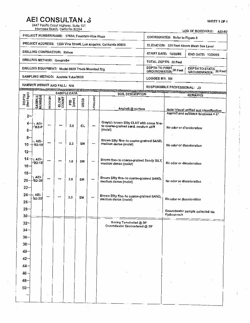
LOG OF BOREHOLE: AEI -B2 PROJECT NUMBER/NAME: 27654; Fountain -Vine Plaza COORDINATES: Refer to Figure 3
PROJECT ADDRESS: 1253 Vine Street, Los Angeles, California 90028 ELEVATION: 321 Feet Above Mean Sea Level
DRILLING CONTRACTOR; Kehoe START DATE: 10/20/05 END DATE: 10/20/05
DRILLING METHOD: Geoprobe TOTAL DEPTH: 30 Feet
DRILLING EQUIPMENT: Model 6600 Truck -Mounted Rig DEPTH TO FIRST30 Feet GROUNDWATER
DEPTH TO STATIC 30 Feet GROUNDWATER:
SAMPLING METHOD: Acetate Tube /5035 LOGGED BY: RN
HAMMER WEIGHT AND FALL: NIA s,+aiMilttePi. , Ft, ,,u_.
RESPONSIBLE °..... =. Win:
PROFESSIONAL: s rzeMe,ya°
JD - aswrEarli
á wm O
-Waasaañsauaiae&mmxavañt s SAMPLE DATA s}azaas -stvñr
REMARKS SOIL DESCRIPTION w am
m ÿ
>
O
r ó= m O
of áa
`. o rn
t ' Asphalt @ surface Note: Visual unified soil classification
2- 4 8-
10-
12-
62.5'
AEl 382 -10
4
-
--
,_
- `- -
__
2.5
2.3
1.6
3.8
3.3
CL
SM
SM
SM
SM
-
-
---
Greyish brown Silty CLAY with some fine - to coarse-grained sand, medium stiff {moist}
Brown Silty fine -to coarse -grained SAND, medium dense (moist)
Brown fine- to coarse grained Sandy SILT medium dense (moist)
medium Silty fine- to coarse -grained SAND,
dense (moist)
Brown Silty fine -to coarse -grained SAND, medium dense (moist)
- Asphalt and subbase thickness = 6"
No odor or discoloration
No odor or discoloration
No odor or discoloration
No odor or discoloration
No odor or discoloration
Groundwater sample collected via Hydropunch
14-
16-
18-
20
22-
24-n 26-
28- 30
AEI- 82.15
AEI- 82.20
AEI- 32.25
32- 34- 36- 38- 40- 42-
44- 46-
48- 50-
Boring Terminated @ 30' Groundwater Encountered @ 30'
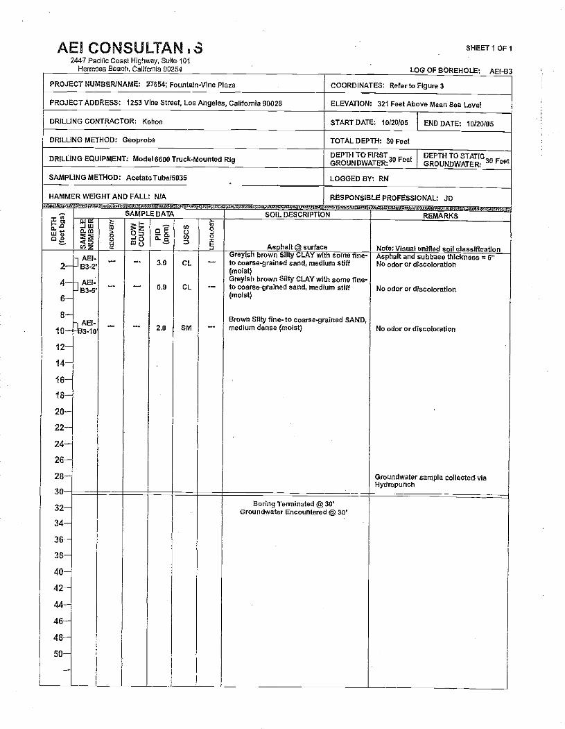
AEI CONSULTAN eS 2447 Pacific Coast Highway, Suite 101
Hermosa Beach, California 90254
SHEET 1 OF 1
LOG OF BOREHOLE: AEI-B3
PROJECT NUMBER/NAME: 27654; Fountain -Vine Plaza COORDINATES; Refer to Figure 3
PROJECT ADDRESS: 1253 Vine Street, Los Angeles, California 90028 ELEVATION: 321 Feet Above Mean Sea Level
DRILLING CONTRACTOR: Kehoe START DATE: 10/20/05 END DATE: 10/20/05
DRILLING METHOD: Geoprobe TOTAL DEPTH: 30 Feet
DRILLING EQUIPMENT: Model 6600 Truck-Mounted Ri 0 DEPTH TO FIRST30
Foot GROUNDWATER: DEPTH TO STAT1630
Feet GROUNDWATER:
SAMPLING METHOD: Acetate Tube /5035 LOGGED BY: RN
HAMMER WEIGHT AND FALL: N/A RESPONSIBLE PROFESSIONAL: JD 36Gl4MtY -43zr, NFFiP2JENfain diszePsia .tPGsi.4, lawkreundair 1R Ay.wcraelFs' 4ó4R- N.iSCYfix%yRM.P ne-¢rrNkAYLI<.
=m SAMPLE DATA SOIL DESCRIPTION REMARKS
WI H ter
p Wá am
8 Óá -á ma,
O O d ÿ gs= - V
m = s Ñ cc 5 Asphalt @ surface Note: Visual unified soil classification AEI Greyish brown Silty CLAY with some fine - Asphalt and subbase thickness c: 6"
1B3-2' 3.0 CL - to coarse -grained sand, medium stiff (moist)
No odor or discoloration 2 4 AS .-.. 0 0.9 .9 CL ... Greyish brown Silty CLAY with some fine- to coarse-grained sand, medium stiff No odor or discoloration
6- (moist)
8- Brown Silty fine- to coarse -grained SAND,
10310 AEI
- 2.0 SM medium dense (moist) No odor or discoloration
12- 14- 16- 18-
20- 22- 24- 26- 28-- Groundwater sample collected via
Hydropunch 30
-
32- Boring Terminated @ 30' Groundwater Encountered @ 30'
34-
36- 38-
40- 42-
44- 46- 48- 50-
AEI CONSULTAN .3 2447 Pacific Coast Highway, Suite 101
Hermosa Beach, California 90254
SHEET 10F1
LOG OF BOREHOLE: AEI -B4 PROJECT NUMBER/NAME: 276541 Fountain -Vine Plaza COORDINATES: Refer to Figure 3
PROJECT ADDRESS: 1253 Vine Street, Los Angeles, California 90028 ELEVATION: 321 Feet Above Mean Sea Level
DRILLING CONTRACTOR: Kehoe START DATE 19120/05 END DATE: 10/20/05
DRILLING METHOD: Geoprobe TOTAL DEPTH: 30 Feet
DRILLING EQUIPMENT: Model 6600 Truck -Mounted RI 8 DEPTH TO FIRST GROUNDWATER: Feet DEPTH DEPTH TO STATIC30
Feet GROUNDWATER: SAMPLING METHOD: Acetate Tube /5035 LOGGED BY: RN
HAMMER WEIGHT AND FALL: N/A RESPONSIBLE PROFESSIONAL: JD
m.._.._ ms,.. ,- swf.}Y31á`t 2dra%Si m^m,.W- ^ reius,t 1.....
S AMP LE DATA ..°,491 .a rJiraur,v7 k.:T[
SOIL DESCRIPTION r- ss
REMARKS áá OuI .32 of ur
U 0 < v, 2 a ma O
6ÿ 5 Asphalt (0 surface Note: Visual unified soil classification
Asphalt and subbase thickness 6" 2- ¢ -] AEI* -W 2.9 CL
Greyish brown Silty CLAY with some fine- to coarse -grained sand, medium stiff No odor or discoloration 6--
84-5' (moist)
8- Brown Silty fine -to coarse -grained SAND, 10- -]6410
AEI 3.1 SM medium dense (moist) No odor or discoloration
12- 14 - AEI -
]64_15 -... -" 16 SM - Brown Silty fine- to coarse -grained SAND,
medium dense (moist] No odor or discoloration 16- 18-
AEI- Brown Silty fine- to coarse- gralned SAND, 20 -]6420 - ^ 3.3 SM
medium dense (moist) No odor or discoloration
22- 24 AEI-
84-25 25 ^ 22 SM - Brown Silty fine -to coarse -grained SAND,
di medium dense (moist) No odor or discoloration 26
28 Groundwater sample collected via 1/4-Inch diameter temporary well 30
32 Boring Terminated @ 30' Groundwater Encountered @ 30'
34
36
38
40
42
44
46
48
50

AEI CONSULTAN 2447 Pacific Coast Highway, Suite 101
Hermosa Beach, California 90254
SHEET 1 OF I
LOG OF BOREHOLE: AEI -B5
PROJECT NUMBER/NAME: 27654; Fountain -Vine Plaza COORDINATES: Refer to Figure 3
PROJECT ADDRESS: 1253 Vine Street, Los Angeles, California 90028 ELEVATION: 321 Feet Above Mean Sea Level
DRILLING CONTRACTOR: Kehee START DATE: 10/20/05 END DATE: 10/20/05
DRILLING METHOD' Geoprobe TOTAL DEPTH: 15 Feet
DRILLING EQUIPMENT: Model 6600 Truck -Mounted Rig 0 DEPTH TO FIRST
WA GROUNDWATER: DEPTH TO STATIC
N/A GROUNDWATER:
SAMPLING METHOD: Acetate Tube/5035 LOGGED BY: RN
HAMMER WEIGHT AND FALL: N/A RESPONSIBLE PROFESSIONAL: JD ;.Af _ . ,y.. ... .- W... :FY ' tf9- n%sm,NO : StttSj .:c jtfl . W .# a. o/;fü + ...uax m. t iktaa': a 1ä9a, Hint - . n ..1iaNH. , e:.:t xt " a - c i are ß ,-, SAMPLE DATA SOIL DESCRIPTION REMARKS m m
ó2
to tL ui
C5 oz
i
o
ik o -O
O dá
8 =
3
Asphalt @ surface Note: Visual unified soll classification
.1
AE 13- 5-2'
A EI'' 655,
AEI- B5 -10
AEI- 85.15
_
_
_
_
2.0
3.3
5.0
3.0
ML
ML
SM
SM
`-
_ -
--
Dark brown Clayey SILT with some fine- to coarse -grained sand, medium dense (moist)
Dark brown Clayey SILT with some fine - to coarse -grained sand, medium dense (moist)
Brown fine- to coarse -grained Sandy SIT, medium dense (moist)
Brown Silty fine -to coarse -grained SAND, medium dense (moist)
Asphalt and subbase thickness = 6"
No odor or discoloration
No odor or discoloration
No odor or discoloration
No odor or discoloration
2
3- 4
§
6- 7- B- 9
10
11- 12- 13- 14
15
16- 17- 18- 19- 20- 21- 22- 23- 24- 25-
Boring Terminated @ 15' No Groundwater Encountered
AEI CONSULTAN IS 2447 Pacific Coast Highway, Suite 101
Hermosa Beach, California 90254
SHEET 10F1
LOG OF BOREHOLE: AEI -B6 PROJECT NUMBER/NAME: 27654; Fountain Vine Plaza COORDINATES: Refér to Figure 3
PROJECT ADDRESS: 1253 Vine Street, Los Angeles, California 90028 ELEVATION: 321 Feet Above Mean Sea Level
DRILLING CONTRACTOR: Kehoe START DATE: 10/20/05 END DATE: 10/20/05
DRILLING METHOD: Geoprobe TOTAL DEPTH: 15 Feet
DRILLING EQUIPMENT: Model 6600 Truck -Mounted Rig DEPTH TO FIRST N/A GROUNDWATER:
DEPTH TO STATIC N/A GROUNDWATER:
SAMPLING METHOD: Acetate Tube /5035 LOGGED BY: RN
HAMMER WEIGHT AND FALL: WA RESPONSIBLE PROFESSIONAL JD tkla !Oftz.Eish:`., P", W-I i ,!a),M,yfFiA.gtr., b , rrvcatulip OV249L'. }á ' TMrsPdzarw .lYàtS,IIíTaNIL*.ttü3bPR Lt SAMPLE DATA SOIL DESCRIPTION REMARKS Só w F.. 6
w1" ám ÓZ of ur
O ct g m 0 o. á co z ,c O 5 Asphalt @ surface Note: Visual unified soil classification
Asphalt and subbase thickness = 6"
1 AEI-
0.8 SM Dark brown fine- to coarse- grained Sandy
No odor or discoloration 2 86.2' SILT, medium dense (moist)
3
4 AEI- Dark brown Clayey SILTwith some fine -
$ 86.5, 1.5 ML . to coarse -grained sand, medium dense (moist)
No odor or discoloration
6
8
9 AEI- Brown fine- to coarse -grained Sandy SILT,
B6 -10 _
1.8 SM medium dense (moist) No odor or discoloration 10
11
12
13
14 AEI- =6.15
-- -- 5.4 SM - Brown Silty fine to coarse -grained SAND, medium dense (moist) No odor or discoloration
15
16 Boring Terminated @15' No Groundwater Encountered
17
18
19
20
21
22
23-
24
25
AD CONSULTAN i S 2447 Pacific Coast Highway, Suite 101
Hermosa Beach, California 90254
SHEET I OF I
LOG OF BOREHOLE: AEI -B7
PROJECT NUMBER/NAME: 27654; Fountain -Vine Plaza COORDINATES: Refer to Figure 3
PROJECTADDRESS: 1253 Vine Street, Los Angeles, California 90028 ELEVATION: 321 Feet Above Mean Sea Level
DRILLING CONTRACTOR: Kehoe START DATE: 10/20/05 END DATE: 10/20/05
DRILLING METHOD: Geoprobe TOTAL DEPTH: 15 Feet
DRILLING EQUIPMENT: Model 6600 Truck -Mounted Rig DEPTH
NIA GROUNDWATER: GROUNDWATER: TO STATIC
GROUNDWATER: N/A
SAMPLING METHOD: Acetate Tube /5035 LOGGED BY: RN
HAMMER WEIGHT AND FALL: N/A °YdF9&áY>úB -+
RESPONSIBLE PROFESSIONAL: JO .
't..'v.'rY,':twW= Mlhâ§áUAaütTA:3Ne+
2 á« W O
9.`H}SI3ùEiMaálEd3 iRffi wit SAMPLE DATA
,v ti}.- ;..vr. SOIL DESCRIPTION
.gg,ll3ä&°..z- YMrkE£hf leal 44 [3kUfD REMARKS
ur tY
á m M
ÿ z s
Z Oó tag
E Ú N
9 o
Asphalt @ surface Note: Visual unified soil classification
1
2
3
AEI- 87-2'
v
w
.._
0.6
2.7
20
1 2
CL
ML
SM
SM
--
--
-_
Dark brown Silty CLAY, medium stiff (moist)
Dark brown Clayey SILT with some fine. to coarse -grained sand, medium dense (moist)
Brown fine -to coarse -grained Sandy SILT, medium dense (moist)
Brown fine- to coarse- grained Sandy SILT, medium dense (moist)
Asphalt and subbase thickness = 6"
No odor or discoloration
No odor or discoloration
No odor or discoloration
No odor or discoloration
4 5
6
7
B
9
'AEI 87.5,
AEI- 87-10
10
11
12
13
14
15
16
17
18
19
20
21
22
23
24-
AEI- 87.15
Boring Terminated @ 15' No Groundwater Encountered
25

AEI CONSULTAN BS 244-7 Pacific Coast Highway, Suite 101
Hermosa Beach, California 90254
SHEET I OF
LOG OF BOREHOLE: AEI-138
PROJECT NUMBER/NAME: 27654; Fountain -Vine Plaza COORDINATES: Refer to Figure 3
PROJECTADDRESS: 1253 Vine Street Los Angeles, California 90028 ELEVATION: 321 Feet Above Mean Sea Level
DRILLING CONTRACTOR: Kehoe START DATE: 10/20105 END DATE: 10120/05
DRILLING METHOD: Geoprobo TOTAL DEPTH: 30 Feet
DRILLING EQUIPMENT: Model 6600 Truck -Mounted Ri g DEPTH TO FIRST
30 Feet GROUNDWATER:
DEPTH TO STATIC Feet GROUNDWATER:
SAMPLING METHOD: Acetate Tube/5035 LOGGED BY: RN
HAMMER WEIGHT AND FALL: N/A rurtga 19 a.,2tai.+wanvwur..Eay.s.,..y,
RESPONSIBLE PROFESSIONAL: JD ¿p{tgEï n.,= s- fhFB° P `.EW1
mi^.St RhAï':Psiz
a.
r
via.. -21RE memie SAMPLE DATA
a, Loli kta.
SOIL DESCRIPTION u glYSTdi 6u1YE .^5 SX.:S)8£âf3d)á
REMARKS
co z á - o
m
ó á á ú
Asphalt @surface Note: Visual unified soll classification AEt- B8.2'
AEI-
AEI
II AEI-
JB8.15
AEI-
j AEI- 88.25
- 2.0
1.6
2.8
2.1
2.7
SM
CL
SM
SM
SM
--
-
-
Dark brown fine- to coarse -grained Sandy SILT, medium dense (moist)
Dark brown Silty CLAY with some fine- to coarse -grained sand, medium stiff (moist)
Brown fine- to coarse -grained Sandy SILT, medium dense (moist)
Brown Silty fine- to coarse -grained SAND, medium dense (moist)
Brown Silty fine - to coarse- grained SAND, medium dense (moist)
Brown Silty fine- to coarse-gralned SAND, medium dense (moist)
As halt or d subbase
thickness =6"
No odor or discoloration
No odor or discoloration
No odor or discoloration
No odor or discoloration
No odor or discoloration
Groundwater sample collected via Hydropunch
2 -]
4 -I 6- 8-
10--6840
12- 14-
16- 18-
20-08-20
22--1
24-
26- 28- 30
32- 34- 36- 38- 40- 42-
44- 46- 48- 50-
Boring Terminated @ 30'' Groundwater Encountered @ 30'
AE6 CONSULTAN .S 2447 Pacific Coast Highway, Suite 101
Hermosa Beach, California 90254
SHEET 1 OF 1
LOG OF BOREHOLE: AEI -B
PROJECT NUMBER/NAME: 27654; Fountain -Vine Plaza COORDINATES: Refer to Figure 3
PROJECT ADDRESS: 1253 Vine Street, Los Angeles, California 90028 ELEVATION: 321 Feet Above Mean Sea Level
DRILLING CONTRACTOR: Kehoe START DATE: 10/20/05 END DATE: 10/20/05
DRILLING METHOD: Geoprobe TOTAL DEPTH: 30 Feet
DRILLING EQUIPMENT: Model 6600 Truck -Mounted Rig DEPTH TO FIRST30
Feet GROUNDWATER: I
DEPTH TO STATIC30 Feet GROUNDWATER:
SAMPLING METHOD: Acetate Tube /5035 LOGGED BY' RN
HAMMER WEIGH t AND FALL: N/A RESPONSIBLE PROFESSIONAL: JD Envz:sxsseSrau;:.a, srta. ra- atxaad + =trrnu?rr`ssscrr-fssrs- ' osnammsausermse aYS ase-ra,
= w SAMPLE DATA SOIL DESCRIPTION REMARKS
ut rL
Cÿ Cm t o Ê N U ó
c3 w mZ o mO
Asphalt @ surface Note: Visual unified soil classification Asphalt and subbase thickness = 6"
2- 4
Poor recovery 6- 8 AEI- Brown fine- to coarse- grained Sandy SILT,
109.10 _- - 1.2 SM - medium dense (moist) No odor or discoloration
12- 14 AEI- Brown Silty fine- to coarsegrained SAND,
69.15 - 1.6 SM "" medium dense (moist) No odor or discoloration 16- 18- 20
AEI. 1 68.20 - - 2.3 SM
Brown Silty fine- to coarse- grained SAND, medium dense (moist) No odor or discoloration
22- 24 - Brown Silty fine- to coarse SAND, coarse-grained
3946 169-25 _ - 4.4 SM - medium dense (moist) No odor or discoloration
26- 28- Groundwater sample collected via
Hydropunch 30
Boring Terminated @ 30' 32- Groundwater Encountered @ 30'
34- 36
38- 40- 42- 44- 46- 48- 50-
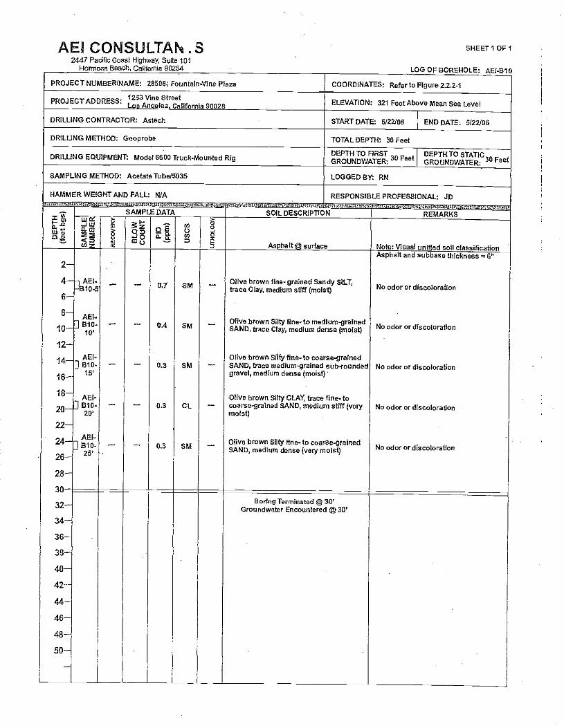
AEI CONSULTAN . S 2447 Pacific Coast Highway, Suite 101
Hermosa Beach, Cali /orals 90254
SHEET 1 OF 1
LOG OF BOREHOLE: AEI -B10
PROJECT NUMBER/NAME: 28508; Fountain -Vine Plaza COORDINATES: Refer to Figure 22.2.1
PROJECT ADDRESS: 1253 Vine Street Los Angeles, California 90028 ELEVATION: 321 Feet Above Mean Sea Level
DRILLING CONTRACTOR: Astech START DATE: 5/22/06 END DATE: 5122 /06
DRILLING METHOD: Geoprobe TOTAL DEPTH: 30 Feet
DRILLING EQUIPMENT: Model 6600 Truck -Mounted Rig 0 DEPTH TO FIRST
30 Feet GROUNDWATER: DEPTH TO STATIC30
Feet GROUNDWATER:
SAMPLING METHOD: Acetate Tube/5035 LOGGED BY: RN
HAMMER WEIGHT AND FALL: N/A RESPONSIBLE PROFESSIONAL: JO .x ...,.. r ....... .y.2:,_
I- á a¢m SAMPLE DATA SOIL DESCRIPTION REMARKS
w c,
} 3z O= 9. §. m o
ó - ó E 2
z 3
gel
-r 0 m u a- 2 .t, Asphalt @ surface Note: Visual unified soil classification
Asphalt and subbase thickness = 6" 2- 4 IAEI-
-810.5 w.
J D 7 SM Olive brown fine- grained Sandy SILT, trace Clay, medium stiff (moist) No odor or discoloration
6- 6 AEi'
Olive brown Silty floe -tomedium- grained 1 B10- -- -- 0A SM `- SAND, trace Clay, medium dense (moist) No odor or discoloration aD 10'
12- AEI- Olive brown Silty fine- to coarse- grained 14-] B10- - - 0.3 SM -- SAND, trace medium-grained sub -rounded No odor or discoloration
16-
16
15'
AEI-
gravel, medium dense (moist)
Olive brown Silty CLAY, trace fine- to 1 B10- -- 0.3 CL --- coarse -grained SAND, medium stiff (very
moist) No odor or discoloration 20
2D'
22- AEI -
J B10- - - 0.3 SM ..- Olive brown Silty fine- to coarse -grained SAND, medium dense moist) No odor or discoloration
26- 25' (very
28- 30
Boring Terminated @ 30' 32- Groundwater Encountered @ 30'
34- 36- 38-
40- 42- 44- 46-
48- 50-

AEI CONSULTAN .S 2447 Pacific Coast Highway, Suite 101
Hermosa Beach, California 90254
SHEET I OF I
LOG OF BOREHOLE: AEI-E311
PROJECT NUMBER/NAME: 28508; Fountain -Vine Plaza . COORDINATES: Refer to Figure 2.2.2-1
PROJECT ADDRESS: 1253 Vine Street Los Angeles. California 90028 ELEVATION: 321 Feet Above Mean Sea Level
DRILLING CONTRACTOR: Astech START DATE: 5/22/08 END DATE: 6/22/06
DRILLING METHOD: Geoprobe TOTAL DEPTH: 30 Feet
DRILLING EQUIPMENT: Model 6600 Truck-Mounted Rig 0 DEPTH TO FIRST
30 Feet GROUNDWATER: DEPTH TO STATIC
30 Feet GROUNDWATER: SAMPLING METHOD: Acetate Tube /5035 LOGGED BY: RN
HAMMER WEIGHT AND FALL: N/A RESPONSIBLE PROFESSIONAL: JD aYa m'9'?xxH.s x ue`3i+H3Heraasn».auua.mæ+ .. ....,r...,. e. ..e ..: ffiYLF
F SAMPLE DATA SOIL DESCRIPTION REMARKS
- Y
% fn i ... « O á ä O
ta z w mO O
á ' x s Asphalt@ surface Note: Visual unified soil classification
Asphalt and subbase thickness = 6" 2-
- W 11.7 SM - Olive brown floe - grained Sandy SILT, trace Clay, medium stiff (moist) No odor or discoloration
4 i
AEI- B11 -5
6-
8 AEI"
Olive brown fine -grained Sandy SILT, 10
1 8101- - 0,5 SM medium stiff (moist) No odor or discoloration
12- 14 AEI
Olive brown fine -grained Sandy SILT, trace
16- i 1311.
ts' _ .0 SM .
Clay, medium stiff (moist) No odor or discoloration
18- AEI- Olive brown Silty fine - to medium- grained
1 811- 20'
- - 0.4 SM - SAND, trace Clay and fine-grained sub- rounded gravel, medium dense (motet)
No odor or discoloration 20
22- AEI- 811- W 0.4 SW _- Olive brown fine- to coarse -grained SAND,
trace Silt and sub- rounded gravel, medium No odor or discoloration 26- 25' loose (very moist)
28- 30
32- Boring Terminated @ 30' Groundwater Encountered @ 30'
34- 36- 38- 40- 42-
44- 46-
48- 50-

AEI CONSULTAN . S 2447 Pacific Coast Highway, Suite 101
Hermosa Beach, California 90254
SHEET 1 OF 1 '
LOG OF BOREHOLE: AEI -B12 PROJECT NUMBER/NAME: 28508; Fountain -Vine Plaza COORDINATES: Refer to Figure 22.2-1
PROJECT ADDRESS: 1253 Vine Street Los Angeles. California 90028 ELEVATION: 321 Feet Above Mean Sea Level
DRILLING CONTRACTOR: Astech START DATE: 5/22106 END DATE: 5122/06
DRILLING METHOD: Geoprobe TOTAL DEPTH: 30 Feet
DEPTH TO FIRST STATI DEPTH TWATERC30
DRILLING EQUIPMENT: Model 6600 Truck -Mounted Rig GROUNDWATER: 30 Feet Feet
SAMPLING METHOD: Acetate Tubet5035 LOGGED BY: RN
HAMMER WEIGHT AND FALL: NIA RESPONSIBLE PROFESSIONAL: JD . w- intreatnarridearniarailfilnionn ffifta 4Eat f £ürfntaitiaz tn.' 4a DATA g_:r.-
REMARKS SAMPLE SOIL DESCRIPTION á
Wro
ur ra
Rm
to z
it
r Ó=
O
9E Ú O
Asphalt @ surface Note: Visual unified soli classification Asphalt and subbase thickness = 6"
2
Olive brown Clayey SILT, trace fine -to 4 AEI- 812 5
6
_. 0.1 ML - medium -grained Sand, medium stiff
(moist) No odor or discoloration
8 AEI- Olive brown SILT, trace Clay and fine - 812- _... - 0.4 ML ' grained Sand, medium stiff (moist) No odor or discoloration 10'
12
14 AEI- 812- .°. - 0.3 SM
Olive brown Silty fine- grained SAND, trace medium -to coarse -grained Sand, medium No odor or discoloration
16 95' loose (moist)
18 AEI - 812- 0,4 CL Olive brown CLAY, medium soft (moist ) No odor or discoloration 20 20'
22- 24 AEI" ] 812- 0.3 SM
Olive brown fine- to coarse -grained Sandy SILT, medium stiff (very No odor or discoloration 26- 25'
moist)
28- 30
32- Boring Terminated @ 30' Groundwater Encountered @ 30'
34- 36- 38-
40- 42- 44- 46-
48- 50-
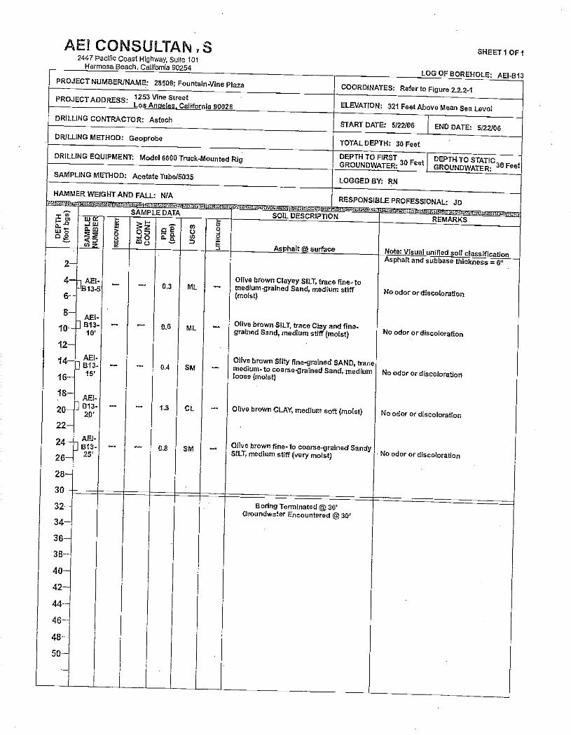
AEI CONSULTAN ,S 2447 Pacific Coast Highway, Suite 101
Hermosa Beach, California 90254
SHEET 1 OF 1
LOG OF BOREHOLE: AEI -B13 PROJECT NUMBER/NAME: 28508; Fountain -Vine Plaza COORDINATES: Refer to Figure 2.2.2 -1
PROJECT ADDRESS: 1253 Vine Street Los Anoeles, California 90028 ELEVATION: 321 Feet Above Mean Sea Level
DRILLING CONTRACTOR: Astech START DATE 5/22/06 END DATE: 5/22J06
DRILLING METHOD: Geoprobe TOTAL DEPTH: 30 Feet
DRILLING EQUIPMENT: Model 6600 Truck -Mounted Rig g DEPTH TO FIRST
30 Feet GROUNDWATER: , DEPTH TO STATICSD
Feet GROUNDWATER; SAMPLING METHOD: Acetate Tube /5035 LOGGED BY: RN
HAMMER WEIGHT AND FALL: N/A RESPONSIBLE PROFESSIONAL- JD
a4 ..aassrs4ft,.a.wcass:rewzas REMARKS
rff3?4rä
d.0 óm
wwaa SAMPLE DATA SOIL DESCRIPTION
JW
.12 áÿ
w
i p s a $
re
m p
Asphalt @ surface Note: Visual unified soil classification '
2
---
w.
^-
---
0.3
0.6
0,4
1.3
0.8
ML
ML
SM
CL
SM
-
°`
-
--
...
Olive brown Clayey SILT, trace fine- to medium-grained Sand, medium stiff (moist)
Olive brown SILT, trace Clay and fine - grained Sand, medium stiff {moist)
Olive brown Silty fine- grained SAND, trace medium to coarse -grained Sand, medium loose (moist)
Olive brown CLAY, medium soft (moist)
Olive brown fine. to coarse-grained Sandy SILT, medium stiff (very moist)
Asphalt and subbase thickness = 6"
No odor or discoloration
No odor or discoloration
No odor or discoloration
No odor or discoloration
No odor or discoloration
B
An- I. t3ó
AEI- 613 - 1D
12
14
16
18
2U
22 84
26
28
30
10'
AEI- B13- 15'
AEI B13- 20'
- 843 25'
32
34
36
3B
40
42
44
46
48
50
Boring Terminated © 30' Groundwater Encountered @ 30'

AEI CONSULTAN ,S 2447 Pacific Coast Highway, Suite 101
Hermosa Beach, California 90254
SHEET 1 OF 1
LOG OF BOREHOLE: AEI -B14 PROJECT NUMBERINAME: 28508; Fountain -Vine Plaza COORDINATES: Refer to Figure 22.2 -1
PROJECT ADDRESS: 1253 Vine Street Los Angeles. California 90028 ELEVATION: 321 Feet Above Mean Sea Level
DRILLING CONTRACTOR: Astech START DATE: 6/29/06 END DATE: 6/29106
DRILLING METHOD: Geoprobe TOTAL DEPTH: 30 Feet
DRILLING EQUIPMENT: Model 6600 Truck -Mounted Rig GR GROO UU
FIRST 30 Feet DEPTH TO STATIC
30 Feet GROUNDWATER: SAMPLING METHOD: Acetate Tube/5035 LOGGED BY: RN
HAMMER WEIGHT AND FALL: N/A RESPONSIBLE PROFESSIONAL: JD i.3:::tlÆ[. r .1 : `_ i5:. - 'x-fx Lfilfitl2.'rflC i'Gfl'.-..:f'J' 4Jffr:'Lkt -- c'G`.63¢tU r3.?t Y: J- is .t`*c3..i,5r,k s!'s nu15. . H+ifxt.sus#a'- :u..Lz..t1 .... ,3'- 'Ya:.U3YP +'i
=á SAMPLEDATA SOIL DESCRIPTION REMARKS wtK O. ám
> óO of ú ó 0 hg, Q0 w mO °.! = co z rc ° á Asphalt @ surface Note: Visual unified soil classification
Asphalt and subbase thickness = 6" 2
4
6.
s AEI- Olive brown fine- to medium- grained I B14- - - 0.2 SM - Sandy SILT, trace Clay, medium stiff No odor or discoloration 10
12 AEI-
1 B14- 0.0 SM - Olive brown fine- to medium- grained Sandy SILT, trace Clay, medium stiff No odor or discoloration
16 15' (moist)
18 AEI - I B14- - - 0.4 CL
-
Olive brown Silty CLAY, trace fine -to coarse- grained Sand, medium soft (moist)
No odor or discoloration 20'
22- AEI- 814- ..- 0.2 SM
_, Olive brown fine- to coarse -grained Sandy SILT, medium stiff (moist) No odor or discoloration
26
26
30
32 Boring Terminated @ 30' Groundwater Encountered @ 30'
34
36
38
40
42
44
46
46
50

AEI CONSULTAN . S 2447 Pacific Coast Highway, Suite 101
Hermosa Beach. Calllornia 90254
SHEET 1 OF
LOG OF BOREHOLE: AEI -B15 PROJECT NUMBER/NAME: 28508; Fountain -Vine Plaza COORDINATES, Refer to Figure 222.1
PROJECT ADDRESS: 1253 Vine Street Los Angeles, California 90028 ELEVATION: 321 Feet Above Mean Sea Level
DRILLING CONTRACTOR: Astech START DATE: 6129(06 END DATE: 6129106
DRILLING METHOD: Geoprobe TOTAL DEPTH: 30 Feet
DRILLING EQUIPMENT: Model 6600 Truck -Mounted Rig 0 DEPTH TO FIRST
30 Feet GROUNDWATER: DEPTH TO STATIC30
Feet GROUNDWATER: SAMPLING METHOD: Acetate Tubef5035 LOGGED BY: RN
HAMMER WEIGHT AND FALL: NIA RESPONSIBLE PROFESSIONAL: JD rAtpag.:.;+" s /c4.,mw+k$ÿ°4%ara -t.at. +A"tStJFlltOJ-- .YkA+e'it4dLS.i 3iñt54ÿt yaj.Y4¿yj. ..Z.li`SSvf r *v ydWsYa?¿ -3.Y . a tj _i!M - }raz z. o }f.::Z{e:'?4:R'::{.'y`l,:dA °.:: taa°_¡:
tfe La
SAMPLE DATA SOIL DESCRIPTION REMARKS utcd ám
Co z
>-
w"
z
F- 3z m tl
nÉ N E
-,, Asphalt @ surface Note: Visual unified soil classification
2- 4- 6-
e- AEI. i E15- 10'
AEI_ B15- 15
AEI- B15- 20'
AEI- ,815-
25'
-
-
--
-
-
---
0.0
S0
0S
0.0
SM
SM
SM
SW
Y-
-
- -
Olive brown fine- to coarse- grained Sandy SILT, trace Clay, medium stiff (moist)
Olive brown fine- to coarse -grained Sandy SILT, trace Clay, medium stiff (moist)
Olive brown fine- to coarse- grained Sandy SILT, some Clay, medium stiff (moist)
Olive brown fine- to coarse -gralned SAND, trace SILT, medium dense (very moist)
Asphalt and subbase thickness = 6"
No odor or discoloration
No odor or discoloration
No odor or discoloration
No odor or discoloration
f0
12- 14-] 16
18
20 22-
24
26- 28- 30
32- 34- 36- 38- 40- 42- 44- 46- 48- 50-
Boring Terminated @ 30' Groundwater Encountered @ 30'

AEI CONSULTAN ,S 2447 Pacific Coast Highway, Sulle 101
le 90254-
SHEET 1 OF 1
LOG OF BOREHOLE: AEI-1316
PROJECT NUMBER/NAME: 28508; Fountain Vine Plaza COORDINATES: Refer to Figure 2.2.2 -1
PROJECT ADDRESS: 1253 Vine Street Los Anodes, California 90028 ELEVATION: 321 Feet Above Mean Sea Level
DRILLING CONTRACTOR: Astech START DATE: 6129/06 END DATE: 6/29106
DRILUNG METHOD: Geoprobe TOTAL DEPTH: 30 Feet
DRILLING EQUIPMENT: Model 6600 Truck -Mounted Rig DEPTH TO FIRST
30 Feet GROUNDWATER: DEPTH TO STATIC
Feet GROUNDWATER:
SAMPLING METHOD: Acetate Tube /5035 LOGGED BY: RN .
HAMMER WEIGHT AND FALL: N/A RESPONSIBLE PROFESSIONAL: JD P.P`S:lf3]S:..i:JYfN: L, TPYwu'° r" w' i' wii'. lWíilrtY. 1,fa'Gb.u.J.;GhE4LáU.G:f.%i24' Off^ ,.S:il1d.:::fi3CVlTCYi:'2:+Ñi: ` A? M1'.:.tf:û:3ñ:YraAJ.gSiE:Y' -iSï: eiRi51a. aHY: Yi2}- 3+. fe£ SS *Sax,v:ii:35`E.'1:5:+°:c.>):.i SAMPLE DATA SOIL DESCRIPTION REMARKS ?w
áa ó-
al CZ
ám 4r CO
z
> u°
m
rr- az Op mV
oÊ aV o
e
'o
4
z $ Asphalt @ surface Note: Visual unified soil classification
2- 4- 6- 8-
10- 12- 14 -] 16- 18-
AEI 616 15'
AEI- 1-ate-
-
- --
-
0.3
0.5
0.3
CL
SM
SM
-
-
Olive brown Silty CLAY, trace fine- to medium-grained Sand, medium soft (moist)
Olive brown fine- to coarse- grained Sandy SILT, trace Clay, medium stiff (moist)
Olive brown fine- to coarse- grained Sandy SILT, some Clay, medium stiff (moist)
Asphalt and subbase thickness = 6"
No odor or discoloration
No odor -or discoloration
No odor or discoloration
20
22- 20'
AEI- 24
26- 28-
B16- 25'
30
32- 34- 36- 38-
40- 42-
44=
46- 48- 50-
Boring Terminated @ 30' Groundwater Encountered @ 30'
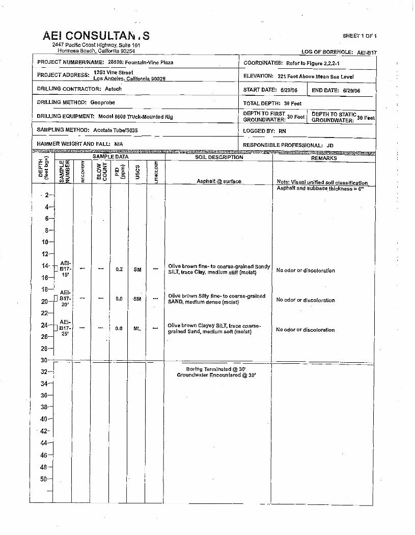
AE! CONSULTAN , S 2447 Pacific Coast Highway, Sulfa 101
Hermosa Beach, California 90254
SHEET 1OF1
LOG OF BOREHOLE: AEI.817
PROJECT NUMBER/NAME: 28508; Fountain -Vine Plaza COORDINATES: Refer to Figure 2.2.2 -1
PROJECT ADDRESS: 1253 Vine Street Los Angeles, California 90028 ELEVATION: 321 Feet Above Mean Sea Level
DRILLING CONTRACTOR: Astech START DATE: 6129106 END DATE: 6129106
DRILLING METHOD: Geoprobe TOTAL DEPTH: 30 Feet
DRILLING EQUIPMENT: Model 6600 Truck -Mounted RI 9 DEPTH TO FIRST GROUNDWATER:
30 Feet DEPTH TO STATIC30
Feet L GROUNDWATER:
SAMPLING METHOD: Acetate Tube /5035 LOGGED BY: RN
HAMMER WEIGHT AND FALL: NIA RESPONSIBLE PROFESSIONAL: JD 5."P ,r a, N. "s'. of '!l 11sYCY- ?'2sslÈti °6W'9 }tJ %T risr'rs .n' r. Jip:.. 'vts'sÁ Se :.a. s V-5.L Sstsr .a.s''shs12k:!r?3-a:YY43YI?tç,. '..py-.a. Ae -._`f
Xm SAMPLE DATA SOIL DESCRIPTION REMARKS ora »
EA.. in e °" ám Ó mO
9E °'.
cyi á °s
co 2 O -°o.
Asphalt liä surface Note: Visual unified soil classification Asphalt and subbase thickness a 6"
2- 4- 6- 8-
10- 12- 14 AEI-
J B17- 0.2 SM Olive brown fine- to coarse -grained Sandy SILT, trace Clay, medium stiff (moist) No odor or discoloration
16- 15'
18 AEI- Olive brown Silty fine- to -
1317 - - - 0.0 SM -- coarse grained
dense SAND, medium dense (moist) No odor or discoloration 20
22-
24 AEI-
) 817- .>_ 0.0 ML - Olive brown Clayey SILT, trace coarse-
No odor or discoloration 25'
grained Sand, medium soft (moist) 26- 28- 30
Boring Terminated @ 30' 32- Groundwater Encountered @ 30'
34- 36- 38-
40- 42- 44-
46-
48- 50-

AEI CONSULTAN .S 2447 Pacific Coast Highway. Suite 101
Hermosa Beech, California 90254
SHEET 1 OF1
LOG OF BOREHOLE: AEI -B18
PROJECT NUMBER/NAME: 28508; Fountain -Vine Plaza COORDINATES: Refer to Figure 2.22 -1
PROJECT ADDRESS: 1253 Vino Street Los Angeles, California 96028 ELEVATION: 321 Feet Above Mean Sea Level
DRILLING CONTRACTOR: Astech START DATE: 7116/06 END DATE: 7/16/06
DRILLING METHOD; Geoprobe TOTAL DEPTH: 37 Feet
DRILLING EQUIPMENT: Model 6600 Truck-Mounted RI 9 DEPTH TO FIRST
37 Feet GROUNDWATER: DEPTH TO STATIC
30 Feet GROUNDWATER:
SAMPLING METHOD: Acetate Tube /5035 LOGGED BY: RN
HAMMER WEIGHT AND FALL: N/A RESPONSIBLE PROFESSIONAL: JD r :a.wsa
I- .0 a ph
4n SAMPLE DATA SOIL DESCRIPTION
to REMARKS
J W a-tp áj W z
g 8 w ec
~ b mÚ
á ñ oá O j e
8 x As haft surface Note: Visual unified soll classification
2
4
6
8 AEI- % BO18-
AEI- 518- 15'
AEI- 1 518-
_
--
-
.-.
---
-
0.0
0.0
0.3
1.3
SM
SM
SM
CL
-
-
Olive brown fine -to medium- grained SILT, trace Clay, medium stiff Sandy
Olive.brown fine -to medium- grained Sandy SILT, trace coarse -grained Sand, medium stiff (moist)
Olive brown fine -to coarse- grained Sandy SILT, trace Clay, medium stiff (moist)
Olive brown fine. to coarse -grained Sandy CLAY, trace Silt, medium soft (very moist)
Asphalt and subbase thickness a 6"
No odor or discoloration
No odor or discoloration
No odor or discoloration
No odor or discoloration
10
12
14
16
18
20
22
20'
AEI- 24
26
28
30
32
34
36
38
40
42-
44
46
48
50
Bí8- 25'
Boring Terminated Q 37' Groundwater Encountered @ 37'
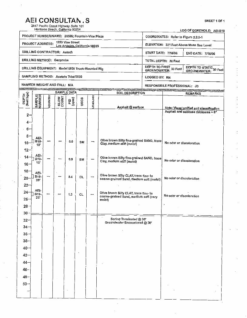
AEI GONSUL.TAN .S 2447 Pacific Coast Highway Suite 101
Hermosa Beach, California 90254
SHEET 1 OF
LOG OF BOREHOLE: AEI.819
PROJECT NUMBER/NAME: 28508; Fountain -Vine Plaza COORDINATES: Refer to Figure 2.2.2 1
PROJECTADDRESS: 1253 Vine Street Los Angeles. California 90028 ELEVATION: 321 Feet Above Mean Sea Level
DRILLING CONTRACTOR: Astach START DATE; 7116106 END DATE: 7/16106
DRILLING METHOD: Geoprobe TOTAL DEPTH: 30 Feet
DRILLING EQUIPMENT: Model 6600 Truck -Mounted RI Rig DEPTH TO FIRST
30 Feet GROUNDWATER: DEPTH TO STATIC30
Feet GROUNDWATER:
SAMPLING METHOD: Acetate Tube/5035 LOGGED BY: RN
HAMMER WEIGHT AND FALL: NIA RESPONSIBLE PROFESSIONAL: JD ktiiit:0li'cf'.1 if`1úr1dP "s! :.. e° yj.a . ^ luYrfl'p:d . °. SYY$í. Sli..: t......,
jSAMPLE fC'.vne 2O.e1:ï41V3.. ,'.a',e .rYL,, -,r..Y '. . -..S ...ia.- -'f.<..¡%::.' '. - atúsJlaYr'. 53l' Lq _'ZuT" ^yt:4 °H^ +.
-Á DATA SOIL DESCRIPTION REMARKS
Jul g Ii 3z yy a am > c;rt of t(
to z m u Asphalt it surface Note: Visual unified soli classification Asphalt and subbase thickness a 6"
2
4
6
8 B 9. , -,,, 0 0 SM _. Olive brown Silty fine- grained SAND, trace Clay, medium stiff (moist) No odor or discoloration 10
10'
12.
14 AEI- Olive brown Silty fine- grained SAND, trace 1 B19- - - 0A SM Clay, medium stiff (moist) No odor or discoloration
16
18
16'
AEI- Olive brown Silty CLAY, trace fine- to B 0.4 CL - coarse -grained Sand, medium soft (moist) No odor or discoloration 20 o9-
22
Olive brown Silty CLAY, trace fine- to 24
26
6E9= 25'
1.3 CL coarse-gralned Sand, medium. soft (very moist)
No odor or discoloration
28
30
32 Boring Terminated @ 30' Groundwater Encountered @ 30'
34
36
38
40
42
44
46
48
50

LOG OF BORING B20
(Page 1 of 1)
Project Fountain- Vine.p01 Fountain -Vine Plaza
Environmental Site Assessment -1253 Vine Street
Los Angeles, California 90028
Date Started Date Completed
Casing Diameter
Drilling Method
Drilling Company Sampling Method
Boring Diameter
Logged By
Prepared By Reviewed By
: April 10, 2013 : April 10, 2013 : N/A
: DPT 6800
: Millennium Env., Inc : Dual -tube continuous core :3.25 -Inch
: Matthew deHaas : Matthew deHaas : Gabriele Baader
Depth in
Feet
o
5- 0844 B20-5
N
É ß E se H
Po
o o. _ Qa.
0
Sample Condition L-' ,{ Disturbed ® Continuous Core (undisturbed)
I I. No Recovery
10- 0848 82040
15- 0053 62045
0357 B20-20
1
25- 0904 820 -25
30- 0910
35-
40 --
820 -30
DESCRIPTION
4 -inch asphalt surface
Hand -augered to 5 feet below ground surface (bgs). SILTY SAND, dark brown (10YR 3/3), medium dense, dry, non- plastic, non-cohesive, fine- grained, no hydrocarbon odor (HCO), no hydrocarbon discoloration (HCD)
Same as above
Same as above. Grades to...
SAND, poorly graded, brown (10YR 4/3), medium dense, dry, fine- grained, no HCO, no HCD
Same as above. Coarsens with depth to...
SAND, well graded, brown (1 DYR 4/3), medium dense, dry, fine- to coarse -gralned, no HCO, no HCD
-
Same as above, trace coarse
Grades to...
SILTY SAND, brown (10YR 4/3), medium dense, dry, non- piastic, non -cohesive, fine -grained, no NCO, no HCD
Same as above
Same as above with intervals of trace coarse- grained sand
Same as above except wet
Bering terminated at 32 feet bgs. Groundwater encountered at approximately 283 feet bgs.
820W collected at 1100 onApdt 10, 2013.
0.0
o.D
0.0
0.0
0.0
0.0
0.0
0.0 Ip
c4
m
Boring: B20
Asphalt
Hydrated Bentonite
GABRIELE E. BAADER
- NO. 7015 y EXP. APR. 30, 2014
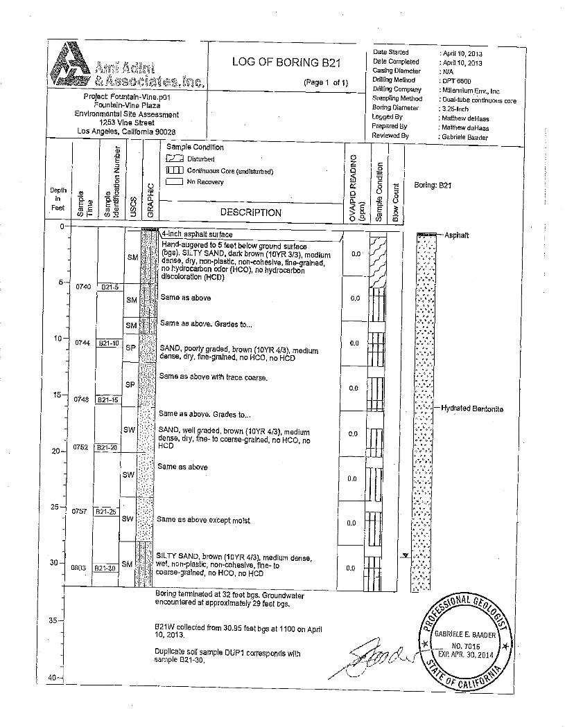
LOG OF BORING B21
(Page 1 of 1)
Project Fountain- VIne.p01 Fountain -Vine Plaza
Environmental Site Assessment 1253 Vine Street
Los Angeles, California 90028
Date Started
Date Completed Casing Diameter Drilling Method Wring Company
Sampling Method Boring Diameter
Logged By
Prepared By
Reviewed By
: April 10, 2013 : April 10, 2013 : NIA
: DPI 6600
Mliennlum Env., Inc : Dual -tube continuous core : 325 -Inch
: Matthew deHaas : Matthew deHaas : Gabriele Baader
Depth in
Feet
m
É01 °t rnF
e`
É z c Á
mú -5á m Ñ to
U 2
0
Sample Condition
le A Disturbed ® Continuous Core (undisturbed)
i I No Recovery
DESCRIPTION
4 -inch asphalt surface Hand- augered to 5 feet below ground surface (bgs). SILTY SAND, dark brown (10YR 3/3), medium dense, dry, non -plastic, non -cohesive, fine- gralned, no hydrocarbon odor (HCO), no hydrocarbon discoloration (HOD)
0740 B21-5
Same as above
Same as above. Grades to,..
10 0744 B21-10
SAND, poorly graded, brown (10YR 4/3), medium dense, dry, fine- grained, no FICO, no HCD
Same as above with trace coarse.
15 0748 921 -15
Same as above. Grades to...
SAND, well graded, brown (10YR 4/3), medium dense, dry, fine- to coarse -grained, no FICO, no
20 0752 FCD 621 -20
Same as above
25 0757
Same as above except moist
30 SILTY SAND, brown (10YR 4/3), medium dense, wet, non -plastic, non -cohesive, fine- to B21-30 0803 coarse -grained, no ROO, no HCD
Boring terminated at 32 feet bgs. Groundwater encountered at approximately 29 feet bgs.
35 1321W collected from 30.95 feet bgs at 1100 on April 10, 2013.
Duplicate soil sample DUP1 corresponds with sample B21 =30.
407
rñ
0.0
0,0
0.0
0,0
00
0.0
0.0
Boring: B21
Asphalt
Hydrated Bentonite
GABRIELE E. BAADER
NO.7015 IXP, APR. 30, 2014
01- CAII`r

LOG OF BORING B22
(Page 1 of 1)
Project Fountain- Vine.p01 Fountain -Vine Plaza
Environmental Site Assessment 253 Vine Street
Los Angeles, California 90028
Date Started
Da te Completed
Casing Diameter
Drilling Method
Drilling Company Sampling Method Boring Diameter Logged By
Prepared By
Reviewed By
: April 10, 2013
:April 11, 2013
: NIA
: DPT 6600
: Millennium Env., Inc
: Dual -tube continuous core : 3.25 -Inch
: Matthew deHaas
: Matthew deHaas
: Gabriele Baader
Depth in
Feet
w
É°1 Ñi-
Ú
U S
o
Sample Condition
F7T4 Disturbed ® Continuous Core (undisturbed)
I I No Recovery
DESCRIPTION
0
5-
10-
15-
20-
25-
30-
35-
40-
1348
1352
1356
1440
1400
1412
SM
; 1\4 -Inch asphalt surface
Hand -augered to 5 feet below ground surface (bgs). SILTY SAND, dark brown (10YR 3/3), medium dense, dry, non -plastic, non -cohesive, fine-grained, no hydrocarbon odor (HCO), no hydrocarbon discoloration (HCD)
B22-5
SM
B22-10
822-20
B22-25
82230 SM
Same as above
Same as above. Grades tó...
SAND, poorly graded, dark yellowish brown (10YR 4/4), medium dense, dry, fine -grained, no HCO, no HCD
Same as above, coarsens with depth.
SAND, well graded, dark yellowish brown (10YR 4/4), medium dense, dry, fine- to coarse -grained, no NCO, no HOD
Grades to...
SILTY SAND, brown (10YR 4/3), medium dense, slightly moist, non -plastic, non -cohesive, fine-grained, no HCO, no HCD
Grades to...
SAND, well graded, brown (10YR 4)3), medium dense, dry, fine -to coarse -grained, no HCO, no HOD
Moisture begins at approximately 27.5 feet bgs.
SILTY SAND, dark grayish brown (10YR 412), medium dense, wet, non -plastic, non -cohesive, fine- grained, no HCO, no HCD
. Boring terminated at 32 feet bgs. Groundwater encountered at approximately 29 feet bgs.
B22W collected from 29.09 feet bgs at 0710 on April 11, 2013.
Duplicate soll sample DUP3 corresponds with sample 822 -30.
0.0
0.0
0.0
o.o
0.0
0.0
0:0
4.0
Boring: 822
Asphalt
Hydrated Bentonite
GABRIELE E BAADER
__- NO.7015 EXP. APR. 30, 2014
F CALtF
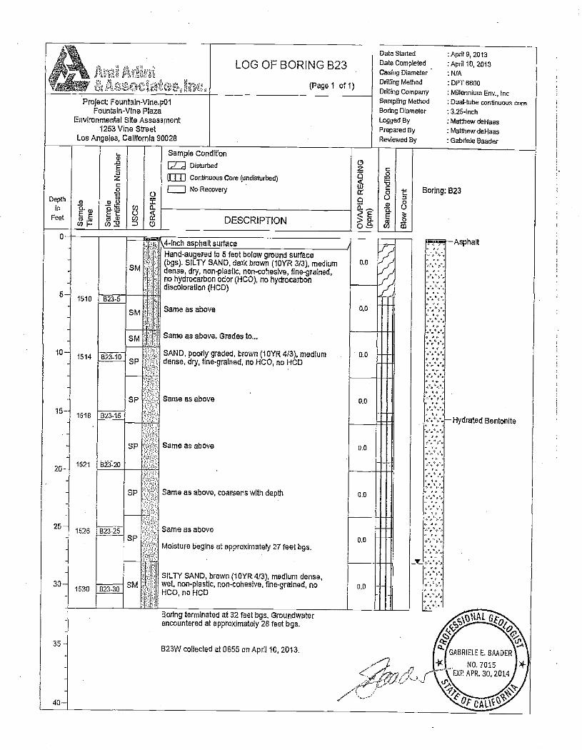
kk'S Asscietates,kw,
LOG OF BORING 323
(Page 1 of 1)
Project Fountaln-Vine.p01 Fountain-Vine Plaza
Environmental Site Assessment 1253 Vine Street
Los Angeles, California 90028
Date Started
Date Completed
Casing Diameter
Drilling Method
Drilling Company Sampling Method
Boring Diameter Logged By
Prepared By
Reviewed By
:April 9, 2013
:April 10, 2013 : N/A
: DP1'6600 : Millennium Env., Inc : Dual-tube continuous core : 3.25-Inch
: Matthew deHaas : MatthewdeHaas : Gabriele Baader
Depth
in
Feet g. oj E col- Or°
a>
o
0 "±" Q-
(9
Sample Condition
I A Disturbed
Di Continuous Core (undisturbed)
I No Recovery
DESCRIPTION
Cl z
6
> o
8
lo
5
20
25
30
35
43
1510
514
1516
1521
1526
1530
SM
B23-5
SM
SM
B23-10 SP
SP
B23-15
SP
B23-20
/17
023-25-
:1¡:.1
SP
SP
B23-30 SM
\4-inch asphalt surface
Hand-augered to 5 feet below ground surface (bgs). SILTY SAND, dark brown (10YR 313), medium dense, dry, non-plastic, non-cohesive, fine-grained, no hydrocarbon odor (HCO), no hydrocarbon discoloration (HOD)
Same as above
Same as above. Grades to._
SAND, poorly graded, brown (10YR 4/3), medium dense, dry, fine-grained, no HCO, no HOD
Santa as above
Same as above
Same as above, coarsens with depth
Same as above
Moisture begins at approximately 27 feet bgs.
SILTY SAND, brown (10YR 413), medium dense, wet, non-plastic, non-cohesive, fine-gralned, no HCO, no HOD
ILO
0,0
DM
0.0
0.0
0.0
0.0
0.0
Boring terminated at 32 feet bgs. Groundwater encountered at approximately 28 feet bgs.
B23W collected at 0655 on April 10, 2013.
Boring: B23
1 -TT Asphalt
Hydrated Bentonite
It(t"
vatAL
GABRIELE E. BAADER
4c NO. 7015 EXP. APR. 30, 2014
Pe CALIF

LOG OF BORING B24
(Page 1 of 1)
Project Fountain-Vine.p01 Fountain-Vine Plaza
Environmental Site Assessment 1253 Vine Street
Los Angeles, California 90028
Date Started
Date Completed
Casing Diameter Drilling Method
Drilling Company Sampling Method Boring Diameter
Logged By Prepared By
Reviewed By
: April 11, 2013 April 11, 2013
: N/A
: DPT 6600 : Millennium Env., Inc : Dual-tube continuous core : 325-Inch : Matthew deHeas : Matthew del-lees : Gabdele Baader
Depth
in
Feet
5-
10-
15-
20
25-
30-
35-
40-
ea. g CD
E
o
e w
-0
8 Cn
o
0
Sample Condition
0 1,-/ A Disturbed
[E]3 Continuous Core (undisturbed)
No Recovery
DESCRIPTION
4-inch asphalt surface Hand-augered to 5 feet below ground surface
sm (bgs). SILTY SAND, dark brown (10YR 3/3), medium dense, dry, non-plastic, non-cohesive, fine-grained, no hydrocarbon odor (HCO), no hydrocarbon discoloration (HOD)
0.0
0906 824-5
sm Same as above 0.0
Same as above
0910 SM Grades to...
0.0 824.10
SAND, poorly graded, brown (10YR 4/3), medium dense, dry, tine-grained, no HCO, no HOD
SP 0.0
Coarsens with depth to... 0914 B24-15
SAND, well graded, dark grayish brown (10YR 4/2), medium dense, slightly moist, fine- to
SW :;..
coarse-grained, no NCO, no HCD 0.0
0918 824-20
Same as above with silt
0.1 Grades to...
0922 SAND, poorly graded, dark yellowish brown (10YR B24-25 SP -!..; 414), medium dense, moist, fine- to coarse-grained,
no HCD, no HCD 0.0
0927 SP Same as above except wet 0.1 924-30
Boring terminated at 32 feet bgs. Groundwater encountered at approximately 28 feet bgs.
B24W collected from 30.30 feet bgs at 1030 on April 11, 2013.
Duplicate soil sample DUP4 corresponds with sample 1324-30.
7-
II
Boring: 824
Asphalt
Hydrated Bentonite
GABRIELE E. BAADER
4c. NO, 7015 4- - EXP. APR, 30, 2014

Depth in
Feet
o
.w frftA.Z6;)
l'itmi,P?;i4..41atc-irs, tint,
LOG OF BORING B25
(Page 1 of 1)
Date Started
Date Completed
Casing Diameter Drilling Method Drilling Company Sampling Method
Boring Diameter Logged By
Prepared By
Reviewed By
:April 9, 2013,
:April 10, 2013 : NIA
DPT 8600
: Millennium Env., Inc : Dual-tube continuous tore : 3.25-Inch
: Matthew deHaas : Matthew deHaas
Gabriele Baader
Project: Fountain-Vine.p01 Fountain-Vine Plaza
Environmental Site Assessment 253 Vine Street
Los Angeles, California 90028
5-
10-
15-
20-
25 -
30-
o to
CO P.
1114 825-5
1113 825-10
1124 1325-15
SM
1129 025-20
SM
SM 1132 025-25
1138
35-
40-
SW
B25-30
Sample Condition
I,-/ l Disturbed
Lai Continuous Core (undisturbed)
No Recovery
DESCRIPTION
-Inch asphalt surface Hand-augered to 5 feet below ground surface (bgs). SILTY SAND, dark brown (10YR 3/3), medium dense, dry, non-plastic, non-cohesive, fine-gralned, no hydrocarbon odor (FICO), no hydrocarbon discoloration (HCD)
Same as above
Same as above. Grades to..
SAND, poorly graded, brown (10YR 4/3), medium dense, dry, fine-grained, trace coarse, no FICO, no HCD
Same as above
Grades to...
SILTY SAND, brown (10YR 413), medium dense, dry, non-plastic, non-cohesive, tine-grained, no 11Q0, no HCD
Same as above
Same as above. Grades to...
SAND, well graded, brown (10YR 4/3), medium dense, moist, fine- to coarse-gralned, no FICO, no HCD
Same as above except wet
Boring terminated at 32 feet bgs. Groundwater encountered at approximately 29 feet bgs.
B25W collected at 0715 on April 10, 2013; duplicate groundwater sample DUP1 also collected.
a
6
a 0
0.0
0.0
0.0
0.0
0.0
0.0
0.0
0.0
co
Boring: B25
Asphalt
Hydrated Bentonite
GABRIELE E. BAADER
F C
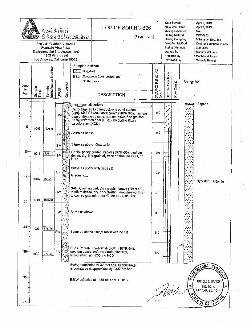
LOG OF BORING B26
(Page 1 of 1)
Project: Fountain- Vlne.p01 Fountain -Vine Plaza
Environmental Site Assessment 253 Vine Street
Los Angeles, Califo nia 90028
Date Started
Date Completed
Casing Diameter
Drilling Method
Drilling Company
Sampling Method
Boring Diameter
Logged By
Prepared By
Reviewed By
: April 9, 2013
: April 9, 2013 : N/A
: OPT 6600
: Millennium Env., Inc : Dual -tube continuous core :3.25 -Inch
: Matthew deHaas
: Matthew deHaas : Gabride Baader
Depth in
Feet
ro
É m co I-
Ú co
U
d
o
Sample Condition
tr' 2 Disturbed
[ELL Continuous Core (undisturbed)
I No Recovery
DESCRIPTION É rr
8
0
5-
10-
15-
20-
25-
30-
1008
1011
1015
1019
1025
1030
SM :;
4 -Inch asphalt surface
Hand- augered to 5 feet below ground surface (bgs). SILTY SAND, dark brown (10YR 3/3), medium dense, dry, non -plastic, non -cohesive, fine- grained, no hydrocarbon odor (HCO), no hydrocarbon discoloration (HCD)
B26-5
828 -10
B26-15
SM:
SM:
SP
SP
926-20
Same as above
Same as above. Grades to...,
SAND, poorly graded, brown (10YR 4/3), medium dense, dry, fine-grained, trace coarse, no HCO, no HOD
Same as above with h trace slit
Grades to...
SAND, well graded, dark grayish brown (10YR 4 /2), medium dense, dry, non -plastic, non -cohesive, fine - to coarse -grained, trace silt, no HCO, no HCD
SW
826 -25 SW
926-30
Same as above except moist with no silt
CLAYEY SAND, yellowish brown (10YR 5/4), medium dense, wet, moderate plasticity, fine -gralned, no HCO, no HCD
0.0
0.0
0.0
0.0
0.0
0.0
00
0.0 ii 1
35-
40-
Boring terminated at 32 feet bgs. Groundwater encountered at approximately 28.6 feet bgs.
826W collected at 1355 on April 9, 2013.
Boring: B26
Hydrated Bentonite

LOG OF BORING B27
(Page 1 of 1)
Project Fountain- VIne.p01 Fountain -Vine Plaza
Environmental Site Assessment 253 Vine Street
Los Angeles, California 90028
Date Started
Data Completed
Casing Diameter Drilling Method Drilling Company Sampling Method
Boring Diameter
Logged By Prepared By
Reviewed By
: April 1D; 2013
: April 10, 2013
:NIA : DPT 6800 : Millennium Env., Inc
Dual -tube continuous core : 3.25 -Inch : Matthew deHaas : Matthew deHaas : Gabriele Baader
Depth in
Feet
v
w 1=
m
2 0
Si 0,40
Ú co
o o. _
0
Sample Condition ® Disturbed
([[O Continuous Core (undisturbed)
L J No Recovery
DESCRIPTION
5- 0948
10- 0952
15- 6957
20- 100
25-7 100
30 1013
SM
B27-5
S
827 -10
SW
B27-15
SW
SP 827-20
B27-25
B27-30
' t \4 -inch asphalt surface
SM 'r
p
SM
SW
Hand -augered to 5 feet below ground surface (bgs). SILTY SAND, dark brown (10YR 3/3), medium dense, dry, non-plastic, non -cohesive, fine- grained, no hydrocarbon odor (HCO), no hydrocarbon discoloration (HCD)
Same as above
Same as above. Grades to,..
SAND, poorly graded, brown (10YR 4/3), medium dense, dry, fine - grained, trace coarse, no HCD, no HCD
Same as above. Coarsens with depth to...
SAND, well graded, brown (10YR 4/3), medium dense, dry, fine -to coarse -grained, no NCO, no HCD
Same as above Grades to...
SAND, Poorly graded, dark grayish brown (10YR 4/2), medium dense, dry, non -plastic, non -cohesive, fine -grained, no H'CO', no HOD Grades to...
SILTY SAND, dark grayish brown (10YR 4/2), medium dense, dry, non -plastic, non -cohesive, fine -grained, no FICO, no HCD Grades to.,.
SAND, well graded, dark yellowish brown (10YR 4/4), medium dense, dry, no HOD, no HCD
Wet below 27.5 feet bgs
Same as above except wet
35-
40-
Boring terminated at 32 feet bgs. Groundwater encountered at approximately 27.5 feet bgs.
B27W collected from 29.85 feet bgs at 1320 on April 10, 2013.
y
Boring: B27
0.0
0.0
0.0
0.0
Asphalt
Hydrated Bentonite
0.0
0.0
0.0
0.8
GABRIELE E. BAADER
NO.7015 * EXP, APR. 30, 2014

LOG OF BORING B28
(Page 1 of 1)
Project Fountain- Vine.pO1 Fountain -Vine Plaza
Environmental Site Assessment 1253 Vine Street
Los Angeles, California 90028
Dale Started
Dale Completed
Casing Diameter
Drilling Method
Drilling Company
Sampling Method
Boring Diameter
Logged By
Prepared By
Reviewed By
: April 10, 2013 : April 11, 2013 : N/A
: DPT6600 : Millennium Env., Inc
Dual-tube continuous core : 3.25 -Inch
: Matthew deHaas : Matthew del-leas : Gabriele Baader
Depth in
Feet
0
m
É m
Ñ r
5- 1107
15-
20-
25-
30-
1115
1119
1126
1132
o
Ñ
Sample Condition
1.2 Disturbed ® Continuous Gore (undisturbed)
No Recovery
DESCRIPTION - :4 -Inch asphalt surface
828 -5
B26-10
826-15
028-20
828-25
028 -30 SM
Hand -augered to 5 feet below ground surface (bgs). SILTY SAND, dark brown (10YR 3/3), medium dense, dry, non -plastic, non -Cohesive, fine-grained, no hydrocarbon odor (HCO), no hydrocarbon discoloration (HCD)
Same as above
Grades to...
SAND, poorly graded, brown (10YR 5/3), medium dense, dry, fine -to medium -grained, trace coarse, no NCO, no HCD
Grades to...
SAND, well graded, brown (10YR 5)3), medium dense, dry, fine -to coarse- grained, no HGO, no HCD
Same as above
Grades to...
SILTY SAND, brown (10YR 4/3), medium dense, dry, non -plastic, non -cohesive, fine -grained, no HCO, no HCD
Grades to...
SAND, well graded, brown (10YR 4/3), medium dense, dry, fine- to coarse -gralned, no HCO, no HCD
Wet below 27.5 feet bgs
Grades to...
SILTY SAND, drak brown (10YR 3/3), medium dense, wet, non -plastic, non -cohesive, fine- to medium -grained, no HCO, no HCD
35-
40-
Boring terminated at 32 feet bgs. Groundwater encountered at approximately 27.5 feet bgs.
B28W collected at 0658 on April 11, 2013.
o.a
0.0
ó b c 8
a
J r lfl
0.0
0.0
0.0
0.0
0.0
Boring: 828
Asphalt
Hydrated Bentonite
0 -0
' GABRIELE E. BAADER
NO.7015 -
EXR APR. 30, 2014
F CAL4F
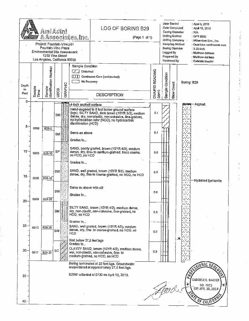
LOG OF BORING 829
(Page 1 of 1)
Project: Fountaln- Vine.p01 Fountain -Vine Plaza
Environmental Site Assessment 1253 Vine Street
Los Angeles, California 90028
Date Started
Date Completed
Casing Diameter Driling Method
Drilling Company Sampling Method
Boring Diameter Logged By
Prepared By
Reviewed By
: April 9, 2013
April 10, 2013 :WA
: OPT 6600
: Millennium Env., Inc : Dual -tube continuous core
: 3.25 -Inch
: Matthew deHaas : Matthew deHaas : Gabriele Baader
Depth in
Feet
o
5-
10-
15-
20-
25 -
30-
35 -
40-
m
É É wt=
0859
0903
0906
0909
0913
0917
8295
029-10
Sample Condition
I2 ,( Disturbed
(j]_[] Continuous Core (undisturbed)
I I No Recovery
DESCRIPTION
\4 -inch asphalt surface Hand -augered to 5 feet below ground surface (bgs). SILTY SAND, dark brown (10YR 3/3), medium dense, dry, none plastic, non -cohesiva, fine- grained, no hydrocarbon odor (HCO), no hydrocarbon discoloration (HCD)
SW%
029-15
829 -20
B29-25
B29-30 SC
Same as above
Grades to...
SAND, poorly graded, brown (10YR 4/3), medium dense, dry, tine- to medium -grained, trace coarse. no HCO, no HCD
Grades to...
SAND, well graded. brown (10YR 5/3), medium dense, dry, fine -to coarse- grained, no HCO, no HCD
Same as above with silt
Grades to...
SILTY SAND, brown (10YR 4/2), medium dense, dry, non -plastic, non -cohesive, fine -grained, no HCO, no HCD
Grades to...
SAND, well graded, brown (10YR 4/2), medium dense, dry, fine- to coarse -grained, no HCO, no HOD
Wet below 27.5feet bgs Grades to... CLAYEY SAND, brown (10YR 4/2), medium dense, wet, non -plastic, non -cohesive, fine- to Medium-grained, no FCO, no HCD
Boring terminated at 32 feet lags. Groundwater encountered at approximately 27.5 feet bgs.
B29W collected at 0730 on Apn110, 2013.
Ó
§oc
U Ú
Boring: 529
Asphalt
Hydrated Bentonite
GABRIELE E. BAADER
NO. 7015 D(P. APR. 30, 2014

fian'il ae.Associ:Seq,hk!,,
LOG OF BORENG B30
(Page 1 of 1)
Project Fountain-Vine.p01 Fountain-Vine Plaza
Environmental Site Assessment 1253 Vine Street
Los Angeles, California 90028
Date Started
Date Completed
Casing Diameter
Drilling Method
Drilling Company
Sampling Method
Boring Diameter
Logged By
Prepared By
Reviewed By
: April 8, 2013
: April a, 2013 : WA : OPT 6500
: Millennium Env., Inc : Dual-tube continuous core
: 3.25-Inch
: Matthew deHaas : Matthew deHaas : Gabriele Baader
Depth in
Feet
o
&-f re -
co
8 to
Sample Condition
A Disturbed
Di Continuous Core (undisturbed)
I I No Recovery
DESCRIPTION
o z o 6 o <E
0
5- 1440
10- 14
15- 1448
20-
25-
30-
35-
1453
1500
1508
830-5
830-10
930-15
SM
SM
SM
SP
SP
930-20
SW
930-25 SW
1330-30 SW
SW
VI-Inch asphalt surface
Hand-augered to 5 feet below ground surface (bgs). SILTY SAND, dark brown (10YR 3/3), medium dense, dry, non-plastic, non-cohesive, fine-grained, trace coarse, no hydrocarbon odor (HCO), rio hydrocarbon discoloration (HOD)
Same as above
Same as above.
Grades to...
SAND, poorly graded, brown (10YR 4/3), medium dense, dry, fine-grained, no HCO, no HOD
Same as above with trace clay
Grades to...
SAND, well graded, brown (10YR 4/3), medium dense, dry, non-plastic, non-cohesive, fine-to coarse-grained, no HCO, no HOD
Same as above with slightly moist, cohesive silt
Same as above
Same as above
40-
Boring terminated at 36 feet bgs. No significant groundwater encountered.
No water sample collected from boring due to proximity to monitoring well MW2.
Boring: 630
Asphalt
Hydrated Bentonite
GABRIELE E. BAADER
NO. 7015 )4- -EXP. 6PR. 30, 2614
A..- F, CAU

LOG OF BORING B31
(Page 1 of 1)
Project: Fountain- Vlne.p01 Fountain -Vine Plaza
Environmental Site Assessment 1253 Vine Street
Los Angeles, California 90023
Date Started
Date Completed Casing Diameter Drilling Method Drilling Company Sampling Method Boring Diameter Logged By Prepared By
Reviewed By
: April 9, 2013
: April 9, 2013 :WA : DPT 6600
: Millennium Env., Inc : Dual -tube continuous core
: 3.25 -Inch
: Matthew deHaas : Matthew deHaas : Gabriele Baader
Depth in
Feet
ro
°i E nH
Ú tie
U
Sample Condition
I ,.1 A Disturbed ® Continuous Core (undisturbed)
I I No Recovery
DESCRIPTION
5 0730
10 0733
15-
20-
25-
0738
30-
35 -
40-
0808
831.5
B31-10
B31-15
B31-32
SW
4 -Inch asphalt surface
Hand -augered to 5 feet below ground surface (bgs). SILTY SAND, dark brown (10YR 3 /3), medium dense, dry, non -plastic, non -cohesive, fine- grained, no hydrocarbon odor (HCO), no hydrocarbon discoloration (HOD)
Same as above
Same as above Grades to...
SAND, poorly graded, brown (10YR4/3), medium dense, dry, fine -grained, no HOD, no HCD
Same as above
No recovery
No recovery
No recovery
Removed dual-tubes from hole to check for obstruction. No obstruction found in shoe or dual -tubes. Tripped back into try to sample 28 to 32 foot interval and check for groundwater.
SAND, well graded, dark grayish brown (10YR 4/2), medium dense, moist, non -plastic, trace cohesive silt, no NCO, no HCD
Boring terminated at 32 feet bgs. No significant groundwater encountered in hydropunch sampler driven from 32 to 36 feet bgs. Set temporary well In
boring.
ß31W collected at 1315 on April S, 2013.
0.0
0.0
0.0
0.0
NR
NR
NR
0.0
Boring: B31
Asphalt
Hydrated Bentonite
VIAL G
GABRIELE E BAADER
N0.7015 IXP. APR. 30, 2014

LOG OF BORING B32
(Page 1 of 1)
Project: Fountain- Vine.p01 Fountain -Vine Plaza
Environmental Site Assessment 253 Vine Street
Los Angeles, California 90028
Date Started
Date Completed
Casing Diameter
Drilling Method
Dolling Company Sampling Method Boring Diameter
Logged By
Prepared By
Reviewed By
: April 11, 2013 : April 11, 2013 : N/A
DPT 6600
: Millennium Env., Inc : Dual -tube continuous core : 325 -Inch
: Matthew deHaas : Matthew deHaas
: Gabriele Baader
Depth
Feet
m
É m
to t=
8
o
CO
Sample Condition
Disturbed
Continuous Core (undisturbed)
I I No Recovery
DESCRIPTION E
m o
5-
10-
15-
20-
25-,
30-
35-
40-
0753
0757
0801
0805
Ogle
0811
\4 -Inch asphalt surface
SM
832 -5
SM
832 -10
SP
832 -15
SP
B32--20
P
832 -25
032-30
SM
Hand -angered to 5 feet below ground surface (bgs). SILTY SAND, dark brown (10YR 3/3), medium dense, dry, non -plastic, non -cohesive, fine- gralned, no hydrocarbon odor (HCO), no hydrocarbon discoloration (HCD)
Same as above with trace coarse
Grades to...
SAND, poorly graded, brown (10YR 413), medium dense, dry, fine- to medium -grained, trace coarse, no NCO, no HCD
Same as above
Same as above
Same as above. Coarsens with depth
Grades to...
SILTY SAND, dark grayish brown (10YR 412), medium dense, dry, non -plastic, non -cohesive, fine- grained, no HCO, no HCD
Wet below 27.5 feet bgs
Same as above except wet
Boring terminated at 32 feet bgs. Groundwater encountered at approximately 27.6 feet bgs.
B32W collected from 31.17 feet bgs at 0925 on April 11, 2013.
Duplicate soil sample DUP2 correspondes with sample 832 -5.
.0
r
Boring: B32
o.D
0.0
o.
0.1
o.
0.5
Asphalt
Hydrated Bentonite
GABRIELE E, BAADER
id NO. 7015 ESP, APR, 30, 2014

LOG OF BORING B33
(Page 1 of 1)
Project: Fountain- Vine.p01 Fountain -Vine Plaza
Environmental Site Assessment 253 Vine Street
Los Angeles, California 90028 .
Date Started
Date Completed Casing Diameter Dnlling Method Drilling Company Sampling Method
Boring Diameter
Logged By
Prepared By
Reviewed By
April 11, 2013 April 11, 2013 N7A
DP76600 Millennium Env., Inc Dual -tube continuous core 3.25 -Inch
Matthew deHaas Matthew deHaas Gabriele Baader
Depth
In
Feet
w
B É 1-
.r, "
2 c
m°(.
c lN v
Ú
Sample Condition
Disturbed ® Continuous Core (undisturbed)
I No Recovery
DESCRIPTION
0
5
10
15
20
25
30
1004
1008
1012
1016
1023
1030
SM
Ri \4 -Inch asphalt surface Hand -augered to 5 lest below ground surface (bgs). SILTY SAND, dark brown (10YR 3/3), medium dense, dry, non -plastic, non-cohesive, fine-grained, no hydrocarbon odor (HCO), no hydrocarbon discoloration (HCD)
633-5
SM Same as above with trace coarse
Grades to...
SAND, poorly graded, brown (10YR 4/3), medium dense, dry, fine- to medium- grained, trace coarse, no HCO, no HCD
833-10
SP Same as above
Coarsens with depth to... 833-15
SW SAND, well graded, brown (10YR 4/3), medium dense, dry, fine- to coarse-grained, no HCO, no HCD
B33-20
SM
Grades to...
SILTY SAND, dark brown (10YR 3/3), medium dense, dry, non -plastic, non -cohesive, fine- grained, no HCO, no HCD
5W
Grades to...
SAND, well graded, brown (10YR 5/3), medium dense, dry, non -plastic, non -cohesive. fine- to coarse -grained, no FICO, no HCD Wet below 27.5 feet bgs
833-25
Same as above except wet. Grades to...
SM
SILTY SAND, dark brown (10YR 3/3) medium dense, wet, non -plastic, cohesive, fine -grained, no HCO, no HCD
833-30
35
40
Baring terminated at 32 feet bgs. Groundwater encountered at approximately 27.5 feet bgs.
633W collected from 30.22 feet bgs at 1115 on April 11, 2013.
0.0
0.0
0.0
1
Boring: 833
Asphalt
0.0
Hydrated Bentonite
0.0
0.0
0.4
0.5
GABRIELE E. BAADER
NO. 7015 IXP. APR. 30, 2014
Exhibit "5"
caNi Water Boards
E01.110 .0 G, BROWN JR.
MATTHEW RODPIONeE
ñrv'ómé.iñi Mm,ennm/
Los Angeles Regional Water Quality Control Board
February 6, 2014
Mr, Carl Van Quathem ALSA Properties 11356 Nutmeg Avenue Los Angeles, CA 90066
SUBJECT: APPROVAL OF REVISED WORK PLAN FOR ADDITIONAL GROUNDWATER ASSESSMENT
CASE /SITE: FOUNTAIN -VINE PLAZA, 1253 VINE STREET, HOLLYWOOD, CA (SITE CLEANUP PROGRAM NO. 1196, SITE ID NO. 2040235)
Dear Mr. Quathem:
The California Regional Water Quality Control Board, Los Angeles Region (Regional Board), is the public agency with the primary responsibility for the protection of ground and surface water quality for all beneficial uses within major portions of Los Angeles and Ventura Counties. The above referenced site is within the Regional Board Boundaries.
On December 18, 2013, the Regional Board approved a work plan for additional groundwater assessment to assess groundwater impacts down -gradient of the site. And on December 24, 2013, the Regional Board requested access to 1245 Vine Street in the City of Los Angeles (the Villa Elaine Apartments) for a groundwater investigation. The Regional Board met with Ms. Julia Jones Patten of the Villa Elaine Apartments and Ami Adini of Ami Adini & Associates on January 10, 2014, to discuss the installation of groundwater monitoring wells at the Villa Elaine Apartments.
During the January 10, 2014 meeting, Ms. Patten raised concerns over the myriad of unmapped subsurface utilities crisscrossing the central courtyard, where the groundwater monitoring wells had been proposed, She further indicated that the building had a historical site designation (City of Los Angeles Designated Historic - Cùltural Monument No, 675). Since the building dates back to the early 1900's, and is constructed of bricks and mortar, it is highly sensitive to vibrations. In addition, Ms. Patten indicated that the tenants were largely comprised of elderly long -term residents, scriptwriters who work or sleep in their domiciles during the day, and a pregnant woman, whom she believes are all highly sensitive to noise, fumes, and disturbances. Based on Ms. Patten's concerns, a consensus was made that the groundwater monitoring wells would be relocated to the northern alley, as the northern alley would reduce the amount of tenants affected by the proposed field operations and that data obtained from groundwater in the northern alley would still be valid for the investigation. Since the northern alley was closer to the source area, and since two of the groundwater monitoring wells could be located less than
MARIA MEHRANIAN, CHAIR I SAMUEL UNGER, EXECUTIVE OFFICER
320 W OSI 411) SL, Su Re 200, Los Angeles, CA 90013 I www,walerboardsma.gov/losangelas
C., RECYCLED PAPER

N.,. an Qaathom - 2 - February 6, 2014 ALSA Properties, Ltd.
forty feet apart, Mr. Adini proposed the installation of two groundwater monitoring wells, as opposed to the initial three, to reduce a possible duplication of work and data. As a result of this meeting, a revised work plan (Revised Down -Gradient Assessment Work Plan, dated January 21, 2014) was submitted to the Regional Board.
The work plan proposes the installation of two (2) groundwater monitoring wells (MW -4 and MW -5) located within the Villa Elaine apartment complex, immediately south of the site (Figure 1). Groundwater will then be sampled from eight (8) groundwater monitoring wells located at the site, at the Villa Elaine apartments, and at Paragon Cleaners (located northeast of the site). Groundwater samples will be analyzed for volatile organic compounds (VOCs) and total petroleum hydrocarbons - gasoline range (TPHg),
On January 28, 2014, Mr. Ami Adini informed the Regional Board that the work plan may be further revised based on structural information that is being provided tohim by Ms. Patten. Since the Villa Elaine Apartments is á historical site, there are some restrictions to drilling. If the location of the groundwater monitoring wells, or the number of the groundwater monitoring wells are modified beyond what has been indicated in the work plan, then you shall inform the Regional Board and get written approval from the Regional Board before you begin installing the groundwater monitoring wells.
Based on information submitted, and on the information in the case file, we concur with the proposed work plan. A technical report shall be submitted electronically to the Regional Board documenting the installation of the groundwater monitoring wells by April 15, 2014. A groundwater monitoring report shall be submitted with the technical report and shall include an analysis of the data obtained from the eight groundwater monitoring wells.
If you have any questions regarding this project, please contact Mr. Henry Jones at (213) 576- 6697 or [email protected]
Sincerely,
ÌGJj '¡
Kwang -il Lee, Ph. D., P.E. Site Cleanup Program Unit IV Chief
Attachment: Figure 1, Proposed Monitoring Well Location Map
Electronic Copies: Mr. Ami Adini, Ami Adini & Associates (amia@amiadini,com) Ms. Julie Jones Patten, Villa Elaine Apartments (juliejonespatten @hotmail.com)
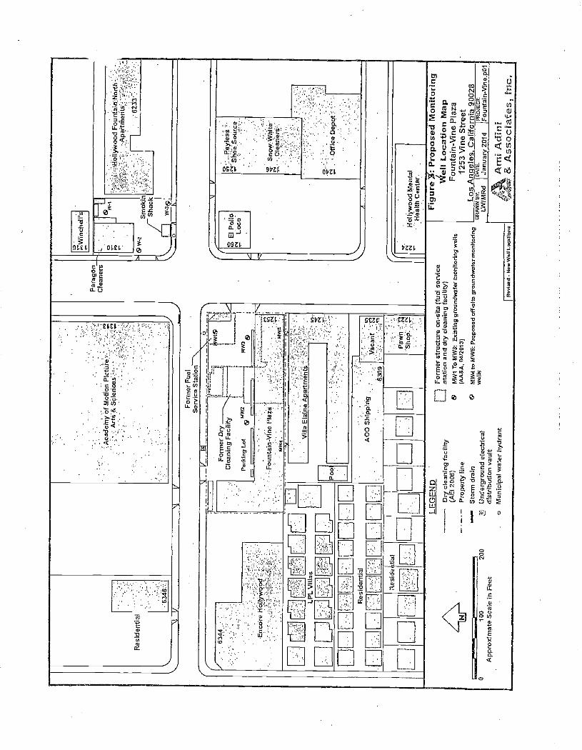
'Ou.)
s aIoossy urn1y uJyy ry
l.od'autA-urelunoj
6LoZ
,4enuer PN
WIM
I :103f0L
i 'aJV
V<
l :A
aNM
Vao
8Z006 e;uloyleo `salaóuy soi
;aalag aul/t £6Z4
ezeld aulA-w
e;unod dew
uoneoo1 Jialç, 6uuo;euow
pasodoud :d77[(
Hap.
ou,oan
SIIa^
euponu w
se{empun J6aylsgapasouad:SM
Ww
amyl
©
[EL
OL
IVO
'VB
tro) sll^M
6uYgN
Ow
JalvMpunae B
u!is!x3 :E
MW
01 tMW
p
(,pppel6u!ueap,(ip Pus uogMS
I i aaIN
BS pnj)911_5-ua aJnjanJjSJaW
IOj .
lueJpRy Jases ledpturtµl
o m
en ugMglJJx!p
»ad u! aleoS e)éw¿xoJddy
geaupa7a punoJ6Jepuq ] O
OZ
001.
0 ueeJP uu07S
au!llyado.:¿ (9000 et()
,in0oej 6u!ueap Lip --
( N3031
vo7uap WIeaH
. IelueyW
-Poos,40oN
S ibdèp.0011x7..
.sJeùaäjp .. Ñ
..e114M
-.imouS
'm
aaJnoS a9NS.-Ñ
. : ssolË
ed.._ ..ó
EE
Z9-
- , ìsl4aw
;ledy-' .
4YoN
[ulejuioj poonuSpoH
:P,
8E-M
JIae4S J u!Jlow
s Z
-M tY
C
o
s, Ia4uuIM,1
slauealp uoßeled
A
h
...:, -sw
uei?S9.g1Jy:'.`.
:70J070ld uoAoW
JP Rw
apeOV
".
A
h
le!wap!sabt

Exhibit "6"

Ami Adini & Associ ,;;ftes, lane
Messrs. Arthur Heath, Kwang -I1 Lee and Henry Jones California Regional Water Quality Control Board, Los Angeles Region 320 West 4th Street, Suite 200 Los Angeles, California 90013
February 12, 2014 Project No. Fountain- Vine.p01
Via E -mail
Re: Further Revised Down -Gradient Groundwater Assessment Work Plan, Fountain -Vine Plaza, 1253 N. Vine Street, Los Angeles, California 90028, LARWQCB SLIC No.1196, Global ID SL0603734628
Dear Messrs. Heath, Lee and Jones,
Ami Adini & Associates, Inc. (AA &A), prepared this Further Revised Down -Gradient Groundwater Assessment Work Plan to present the objectives and proposed scope of work for additional down -gradient subsurface investigation in connection with the referenced site (see attached Figures 1 and revised Figure 2). The original Down - Gradient Groundwater Assessment Work Plan, dated December 9, 2013, and the Revised Down- Gradient Groundwater Assessment Work Plan, dated January 21, 2014 approved by the Los Angeles Regional Water Quality Control Board (LARWQCB) in letters dated December 18, 2013, and February 6, 2014, are hereby being revised and resubmitted due to concerns of affecting the structural integrity and /or network of utilities of the Villa Elaine Apartment property located at 1245 N. Vine Street, Los Angeles, California. Accordingly, this Further Revised Work Plan is being submitted on behalf of our client, the property owner of the Fountain -Vine Plaza property, ALCA Properties, Ltd. (ALCA). AA &A continues to invest special care to address all objectives and concerns expressed to AA &A by staff at the LARWQCB during the numerous meetings and discussions regarding the site.
INTRODUCTION AND BACKGROUND INFORMATION
This further revised work plan involves the relocation of the two proposed groundwater monitoring wells MW4 and MW5, The initial Revised Down - Gradient Groundwater Assessment Work Plan, dated January 21, 2014 was submitted to the LARWQCB and subsequently approved in a letter dated February 6, 2014 (attached). The scope of work included in the revised work plan involved the installation and sampling of two groundwater monitoring wells, identified as MW4 and MW5 which were proposed to be installed in the alley /pathway at the northern border of the Villa Elaine Apartments apartment complex located adjacently south of the site.
Subsequent to the approval of the revised work plan, AA &A was informed by the Villa Elaine Apartments that the footing of the foundation extends four feet beyond the building and could not be cut or underpinned. Since the approved well locations in northern alley /pathway were no longer viable locations without affecting the integrity of the Villa Elaine Apartments, a site meeting was requested with representatives of the LARWQCB to discuss alternative well locations.
On February 11, 2014, a meeting was conducted at the site. The meeting was attended by Messrs. Kwang -il Lee and Henry Jones of the LARWQCB, Mses. Julie Patten and Erin Russell of the Villa Elaine Apartments, Mr. Carl Van Quathem of ALCA Properties, Mr. Ravi Arulanantham of GeoSyntec, and Mr. Ami Adini of AA &A. During the meeting a revised scope of work was developed that is presented in this work plan,
4130 Cahuenga Blvd., Ste. 113 o Los Angeles, CA 91602 Phone 818.824.8102 Fax 818.824.8112 www.amiadini.com o mail @amiadini.com

Further Revised Down -Gradient Groundwater Assessment Work Plan Fountain -Vine Plaza, 1253 Vine Street, Los Angeles, California 90028 February 12, 2014
Page 2
SCOPE OF WORK
The scope of work for this environmental site assessment includes the following:
Advance two off -site, hollow -stem auger borings from grade to approximately 45 feet below ground surface (bgs) as shown on revised Figure 3. Well MW4 is proposed to be installed in the vicinity of the abandoned swimming pool at the Villa Elaine Apartments at a minimum distance of 20 feet from the exterior wall of the building. Well MW5 is proposed to be installed in the sidewalk or parking lane near the northeast comer of the Villa Elaine Apartments at a minimum distance of 4 feet from the exterior wall of the building. The final location of well MW5 will be determined based on the locations of subsurface utilities and encroachment permitting requirements.
Soil samples will be collected from each of the borings at 5 -foot intervals for lithologic evaluation and field screening of volatile organic compounds (VOCs) using a photo -ionization detector (PID) calibrated to a 100 parts per million (ppm) isobutylene standard. No soil samples will be submitted for laboratory analysis.
Prior to initiating field activities, AA &A will update the community health and safety plan (HSP) for the proposed activities. The HSP will be reviewed by all parties involved in the completion of daily tasks prior to the start of work each day.
Completion of the borings as groundwater monitoring wells identified as MW4 and MW5. The locations of the wells were selected to identify groundwater conditions in the down -gradient direction of the former dry cleaning equipment located on the Fountain -Vine Plaza site as well as conditions down -gradient of the Paragon Cleaners site. Additionally, the locations were selected so not to affect the structural integrity of the Villa Elaine Apartments.
Construction of the wells using 1 -inch diameter, schedule 40, perforated PVC screen and blank well materials. The screened intervals of the wells will extend from approximately 25 to 45 feet bgs. A proposed well construction diagram is provided as Figure 4.
Development of the new wells a minimum 72 hours after installation to improve the hydraulic communication between the geologic formation and the well by removing suspended solids. Well development will be completed using a surge block and bailer or submersible pump. Well development will be continued until the following is achieved:
o Lip to five well volumes of fluids are extracted from each well;
o The temperature, pH, conductivity, and turbidity of the removed water has stabilized; and
o Suspended solids have been removed so that the water is clear of cloudiness or turbidity (visual observation), and the silt buildup at the bottom of the wells has been removed. The total well depth will be measured during well development to monitor the removal of silt buildup.
The elevations of the newly installed groundwater monitoring wells will be surveyed relative to the known benchmark by a California- licensed land surveying company. The top of the well casings, cover of the wells, and the ground surface will be measured in feet relative to the North American Vertical Datum of 1988.
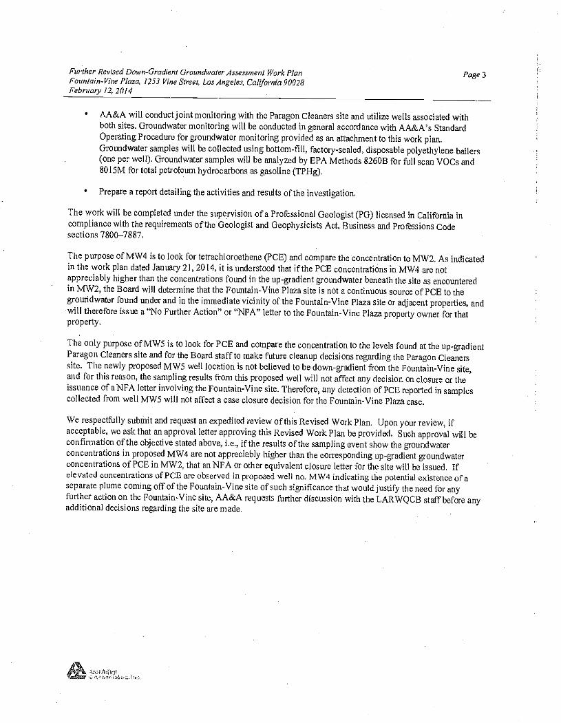
Further Revised Down -Gradient Groundwater Assessment Work Plan Fountain -Vine Plaza, 1253 Vine Street, Los Angeles, California 90028 February 12, 2014
Page 3
AA &A will conduct joint monitoring with the Paragon Cleaners site and utilize wells associated with both sites. Groundwater monitoring will be conducted in general accordance with AA &A's Standard Operating Procedure for groundwater monitoring provided as an attachment to this work plan. Groundwater samples will be collected using bottom -fill, factory -sealed, disposable polyethylene bailers (one per well). Groundwater samples will be analyzed by EPA Methods 8260B for full scan VOCs and 8015M for total petroleum hydrocarbons as gasoline (TPHg).
Prepare a report detailing the activities and results of the investigation.
The work will be completed under the supervision of a Professional Geologist (PG) licensed in California in compliance with the requirements of the Geologist and Geophysicists Act, Business and Professions Code sections 7800-7887.
The purpose of MW4 is to look for tetrachloroethene (PCE) and compare the concentration to MW2. As indicated in the work plan dated January 21, 2014, it is understood that if the PCE concentrations in MW4 are not appreciably higher than the concentrations found in the up- gradient groundwater beneath the site as encountered in MW2, the Board will determine that the Fountain -Vine Plaza site is not a continuous source of PCE to the groundwater found under and in the immediate vicinity of the Fountain -Vine Plaza site or adjacent properties, and will therefore issue a "No Further Action" or "NFA" letter to the Fountain -Vine Plaza property owner for that property.
The only purpose of MW5 is to look for PCE and compare the concentration to the levels found at the up- gradient Paragon Cleaners site and for the Board staff to make future cleanup decisions regarding the Paragon Cleaners site. The newly proposed MW5 well location is not believed to be down -gradient from the Fountain -Vine site, and for this reason, the sampling results from this proposed well will not affect any decision on closure or the issuance of a NFA letter involving the Fountain -Vine site. Therefore, any detection of PCE reported in samples collected from well MW5 will not affect a case closure decision for the Fountain -Vine Plaza case.
We respectfully submit and request an expedited review of this Revised Work Plan. Upon your review, if acceptable, we ask that an approval letter approving this Revised Work Plan be provided. Such approval will be confirmation of the objective stated above, i.e., if the results of the sampling event show the groundwater concentrations in proposed MW4 are not appreciably higher than the corresponding up- gradient groundwater concentrations of PCE in MW2, that an NFA or other equivalent closure letter for the site will be issued. If elevated concentrations of PCE are observed in proposed well no. MW4 indicating the potential existence of a separate plume coming off of the Fountain -Vine site of such significance that would justify the need for any further action on the Fountain -Vine site, AA &A requests further discussion with the LARWQCB staff before any additional decisions regarding the site are made.

Further Revised Down- Gradient Groundwater Assessment Work Plan Fountain -Vine Plaza, 1253 Vine Street, Los Angeles, California 90028 February 12, 2014
Page 4
If you have any questions regarding this work plan, please contact us at (818) 824 -8102.
Respectfully submitted,
AMI ADTNT & ASSOCIATES, INC.
This Further Revised Down -Gradient Groundwater Assessment Work Plan has been prepared by
ONAL04 --0
4 -k
/ Matthew R. deHaas, PG Senior Geologist Professional Geologist No. 8535, Expiration Date 11/30/14
and approved by
MATTHEW R. deHAAS
NO. 8535 IXP. NO V.
CALO
s f9l
FF CALS
Ami Xdini President, Principal Environmental Consultant NREP Registered Environmental Professional No. 2614 General Engineering /Hazardous Waste Contractor No. 587540 B. Sc. Mech. Eng
cc: Addressee (PDF) Mr. Carl Van Quathem (PDF)
Attachments:
Attachment A: Figures ] through 4 Figure 1 - Site Vicinity Map Figure 2 - Site Map with PCE Plume in Groundwater Figure 3 - Proposed Monitoring Well Location Map Figure 4 - Well Construction Diagram
Attachment B: LARWQCB Correspondence dated December 18, 2013
kh

Further Revised Down -Gradient Groundwater Assessment Work Plan Fountain -Vine Plaza, 1253 Vine Street, Los Angeles, California 90028 February 12, 2014
ATTACHMENT A
Figures 1 through 4


PC
E
Con
cent
ratio
ns
in p
g /L
J.a0
0
2500
NO
-: :
6346
Aca
dem
y of
Mot
ion
P)c
ture
-A
rts
& Sc
ienc
es
. F
orm
e S
ervi
T.
Par
ag
Cle
aner
s
ciW
iücÍ
iëll'
s 65
Hel
l ro
od F
ount
ain
Nor
th
Apa
rtm
ents
-
_ 62
33 -
okin
ta
ckte
12
1 II
W -3
B
Enc
ore
Ho
lyw
ood
LPL
Vill
as
Res
iden
t al
For
mer
Dry
C
lean
ing
Fac
ility
Par
king
Lot
Fou
nfal
-V
ine
MW
4
Poo
W1
1,50
0'-'.
:
MW
2 09
261
- 1,
460
Vill
a E
lain
e A
part
en
AO
O S
P
P-n
9 _
'
4Vac
ant
.-
- -c
ano
. a
NO
TE
: T
wo
loca
tions
for
pro
pose
d w
ell
MW
5 sh
own
on m
ap,
only
one
w
ell
to b
e in
stal
led.
Fin
al lo
catio
n to
be
dete
rmin
ed b
ased
on
loca
tion
of
unde
rgro
und
utili
ties
and
encr
oach
men
t pe
rmitt
ing
requ
irem
ents
1
I -T
I
I
I
o
loo
App
roxi
mat
e S
cale
in F
eet
200
LEG
EN
D
Dry
cle
anin
g fa
cilit
y (A
EI
2006
) -
Pro
pert
y lin
e
Sto
rm d
rain
Und
ergr
ound
ele
ctric
al
dist
ribut
ion
vaul
t o
Mun
icip
al w
ater
hyd
rant
E_
awn
Sho
p
áw
ñ iP
ayl,é
ss.
`:-1
S
hòe'
Sou
rcl
Ñ
Sno
w W
hite
C
lean
ers
Offi
ce D
epot
:
A
rr N
H
ölly
woc
d M
enta
l "
Hea
ith'C
ente
r -
-
For
mer
str
uctu
re o
n -s
ite (
fuel
ser
vice
...
.. .1
st
atio
n an
d dr
y cl
eani
ng fa
cilit
y)
s
6,16
0
MW
I T
o M
W3:
Exi
stin
g gr
ound
wat
er m
onito
ring
wel
ls
(AA
&A
, 041
2013
)
MW
4 to
MW
5: P
ropo
sed
off-
site
gro
undw
ater
mon
itorin
g w
ells
PC
E C
once
ntra
tion
in g
roun
dwat
er In
mic
rogr
ams
per
liter
(pg
/L)
Fig
ure
2: S
ite M
ap w
ith P
CE
P
lum
e in
Gro
undw
ater
- 4/
16/1
3 F
ount
ain
-Vin
e P
laza
12
53 V
ine
Str
eet
Los
Ang
eles
C
alifo
rnia
900
28
DR
AW
N B
Y:
DA
TE
P
RO
JEC
T.
LW /M
Rd
Feb
ruar
y 20
14
IFou
ntai
nNin
e.p0
1
Rev
ised
- N
ew W
ell
Loca
tions
X
Am
i A
dáor
B
& A
ssoc
iate
s, I
nc.

14£1 -
e o ea
E ul 3 en
a 2 E ga
o
r 0 ,
o
a-keg
9421-1-
7
0
\IIIO,09Z
\I V
o ct, r WI r o
9 11
1.2i1.$ SNIA
o
0.
Or o ,
raa'orro.
o oc ot .2
c o t 'ci g E co a)
c o- 10
C 6-
sP'F o bc
O E
.2 a)
rt =0 t. o 3 o E
c 0 o
ZO CL el U 0 ct 0 a)
j.5 2 E OLL. C 0 0 -0
0 RS
O 'tj'j -43
C C 0 - a) .f2
6 . s-
0 °.) 1.11 ° z
ai 0 al
e e
`St to 4 :sill
4 cif
4h
la
P3
a LI.
C
O
co u 0(0 o
o.
o
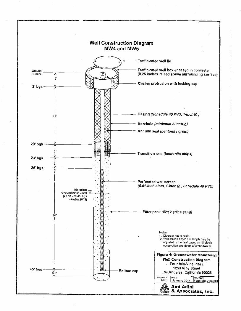
Ground Surface
2' bgs
2'
20' bgs
23' bgs
25' bgs
45' bgs
18'
Well Construction Diagram MW4 and MW5
+y Traffic -rated well box encased in concrete (0.25 inches raised above surrounding surface)
i
Traffic -rated well lid
T 3'
2' y
Historical Groundwater Level g
(26.58 - 29.43' bgs -AA &A 2013)
20'
0.5 W
Casing protrusion with locking cap
Casing (Schedule 40 PVC, 1 -inch 01)
Borehole (minimum 5 -inch 0)
Annular seal (bentonite grout)
Transition seal (bentonite chips)
Perforated well screen (0.01 -inch slots, 1 -inch 0, Schedule 40 PVC)
Bottom cap
Filter pack ( #2/12 silica sand)
Notes: 1. Diagram not to scale. 2. Well screen depth and length may be
adjusted in the field based on Ilthologic observation and depth of groundwater.
Figure 4: Groundwater Monitoring Well Construction Diagram
Fountain -Vine Plaza 1253 Vine Street
Los Angeles, California 90028 DRAWN BY:
MRd DATE:
January 2014
Ami Adini J & Associates, Inc.
PROJECT:
Fountain- VIne.pO

Further Revised Down- Gradient Groundwater Assessment Work Plan Fountain -Vine Plaza, 1253 Vine Street, Los Angeles, California 90028 February 12, 2014
ATTACHMENT B
LARWQCB Correspondence
ranN11
Water Boards
EYMUIIn G. Rnowl JR. oOVEnnon
MATTHEW ROORmuE
ÉEINnONMnIr1Al NWT.,N
Los Angeles Regional Water Quality Control Board
February 6, 2014
Mr. Carl Van Quathem ALSA Properties 11356 Nutmeg Avenue Los Angeles, CA 90066
SUBJECT: APPROVAL OF REVISED WORK PLAN FOR ADDITIONAL GROUNDWATER ASSESSMENT
CASE /SITE: FOUNTAIN -VINE PLAZA, 1253 VINE STREET, HOLLYWOOD, CA (SITE CLEANÜP PROGRAM NO. 1196, SITE ID NO. 2040235)
Dear Mr. Quathem:
The California Regional Water Quality Control Board, Los Angeles Region (Regional Board), is the public agency with the primary responsibility for the protection of ground and surface water quality for all beneficial uses within major portions of Los Angeles and Ventura Counties, The above referenced site is within the Regional Board Boundaries.
On December 18, 2013, the Regional Board approved a work plan for additional groundwater assessment to assess groundwater impacts down -gradient of the site. And on December 24, 2013, the Regional Board requested access to 1245 Vine Street in the City of Los Angeles (the Villa Elaine Apartments) for a groundwater investigation. The Regional Board met with Ms. Julia Jones Patten of the Villa Elaine Apartments and Ami Adini of Ami Adini & Associates on January 10, 2014, to discuss the installation of groundwater monitoring wells at the Villa Elaine Apartments.
During the January 10, 2014 meeting, Ms. Patten raised concerns over the myriad of unmapped subsurface utilities crisscrossing the central courtyard, where the groundwater monitoring wells had been proposed. She further indicated that the building had a historical site designation (City of Los Angeles Designated Historic - Cultural Monument No. 675). Since the building dates back to the early 1900's, and is constructed of bricks and mortar, it is highly sensitive to vibrations. In addition, Ms. Patten indicated that the tenants were largely comprised of elderly long -terns residents, scriptwriters who work or sleep in their domiciles during the day, and a pregnant woman, whom she believes are all highly sensitive to noise, fumes, and disturbances, Based on Ms. Patten's concerns, a consensus was made that the groundwater monitoring wells would be relocated to the northern alley, as the northern alley would reduce the amount of tenants affected by the proposed field operations and that data obtained from groundwater in the northern alley would still be valid for the investigation. Since the northern alley was closer to the source area, and since two of the groundwater monitoring wells could be located. less than
MARIA MEHPANIAN, CHAIR I SAMUEL UNDER, EXECUTIVE 0E991E11
20 West nth SI., Susto 200, Los Angeles. CA 90013 t www,watarboards.ca.gov /losang eles
,, Ivavpon aAPEn

Mr. Carl Van Quathem ALSA Properties, Ltd.
- 2 - February 6, 2014
forty feet apart, Mr. Adini proposed the installation of two groundwater monitoring wells, as opposed to the initial three, to reduce a possible duplication of work and data, As a result of this meeting, a revised work plan (Revised Down -Gradient Assessment Work Pian, dated January 21, 2014) was submitted to the Regional Board.
The work plan proposes the installation of two (2) groundwater monitoring wells (MW -4 and MW -5) located within the Villa Elaine apartment complex, immediately south of the site (Figure I), Groundwater will then be sampled from eight (8) groundwater monitoring wells located at the site, at the Villa Elaine apartments, and at Paragon Cleaners (located northeast of the site). Groundwater samples will be analyzed for volatile organic compounds (VOCs) and total petroleum hydrocarbons - gasoline range (TPHg).
On January 28, 2014, Mr. Ami Adini informed the Regional Board that the work plan may be further revised based on structural information that is being provided to him by Ms, Patten. Since the Villa Elaine Apartments is a historical site, there are some restrictions to drilling. If the location of the groundwater monitoring wells, or the number of the groundwater monitoring wells are modified beyond what has been indicated in the work plan, then you shall inform the Regional Board and get written approval from the Regional Board before you begin installing the groundwater monitoring wells.
Based on information submitted, and on the information in the case file, we concur with the proposed work plan. A technical report shall be submitted electronically to the Regional Board documenting the installation of the groundwater monitoring wells by April 15, 2014. A groundwater monitoring report shall be submitted with the technical report and shall include an analysis of the data obtained from the eight groundwater monitoring wells.
If you have any questions regarding this project, please contact Mr. Henry Jones at (213) 576- 6697 or hjones @waterboards.ca.gov
Sincerely,
.._.. -- Kwang-il Lee, Ph. D., P.E.
Site Cleanup Program Unit PI Chief
Attachment: Figure 1, Proposed Monitoring Well Location Map
Electronic Copies: Mr. Ami Adini, Ami Mini & Associates (amia @amiadini.com) Ms. Julie Jones Patten, Villa Elaine Apartments (juliejonespatten @hotmail.com)

Res
iden
tial
V
V
_ _
Aca
dem
y of
Mot
ion
Pic
ture
:.-
A
rts
& S
cien
ces
. .
g
,
V
V
For
mer
Fue
l S
ervi
ce S
tatio
n
Enc
ore
Ho
lyw
ocia
r I ll
. F
orm
er D
ry
.-..:
' ;'.
..::.
Cle
anin
g F
acili
t---
---i
Par
king
Lot
,
Fou
ntai
n-V
ine
Pla
za
MW
4
MW
, o
r
Din
tiDD
R
esid
entia
l
A.-
.f-
-41l
liEfa
ii4-1
,454
t(iia
tIR
Faâ
-
_ - A
00
_
0 S
hipp
ing:
V
acan
t n
_ 62
09
.
Res
ide
Iii tia
0 10
0
App
roxi
mat
e S
eale
in
Fee
t
Par
agon
_.
Cle
aner
s
Tr,
Win
ttiau
ti ad
exal
leltr
alle
ll
6, W
-2
_..-
idia
llYV
ränd
Fou
ntai
n N
orth
Sha
ck
1..:-
:;'
W-3
4;
Le,
Pa;
rlins
t V
- S
hoe
Sou
rce
- _
Sno
w W
hite
C
lean
ers
Off
iceD
epot
A
h
-.:4
1ear
iiire
erfiC
?
LEG
EN
D
F-1
F
orm
er s
truc
ture
on-
site
(fu
el s
ervi
ce
stat
ion
and
dry
clea
n ng
faci
lity)
to
Nt
To
MW
O:
Exi
stin
g gr
ound
wat
er m
onito
ring
wel
ls
(AA
&A
, 04
/201
1)
@
MW
4 to
MW
S:
Pro
pose
d of
f-si
te g
roun
dwat
er m
ni
torin
g w
ells
Fig
ure
Pro
pose
d M
onito
ring
Mie
n Lo
catio
n M
ap
Fou
ntai
n-V
ine
Pla
za
1253
Vin
e S
tree
t Lo
s A
ngel
es,
Cal
iforn
ia 9
0028
Dry
cle
anin
g fa
cilit
y (A
EI
2005
)
Pro
pert
y lin
e
Sto
rm d
rain
Und
ergr
ound
ele
ctric
al
dist
ribut
ion
vaul
t a
Mun
icip
al w
ater
hyd
rant
200
DR
AW
N
BY
: O
AT
E.
PR
OJE
CT
. LW
!MR
d Ja
nuar
y 20
14
Fou
ntai
n-V
ine.
p01
mi
Ad
it'd
(Lrt
ta
Rr
& A
SS
at e
s ,
Rav
iad
. New
WO
O L
OC
aliO
rIS
Exhibit "7"

=eur
Water Boards
Los Angeles Regional Water Quality Control Board
March 3, 2014
Mr. Carl Van Quathem ALSA Properties 11356 Nutmeg Avenue Los Angeles, CA 90066
SUBJECT: RESPONSE TO A REQUEST FOR THE FURTHER REVISED WORK PLAN EMAILED ON FEBRUARY 18, 2014
CASE /SITE: FOUNTAIN -VINE PLAZA, 1253 VINE STREET, HOLLYWOOD, CA (SITE CLEANUP PROGRAM NO. 1196, SITE ID NO. 2040235)
Dear Mr. Quathem:
On February 6, 2014, California Regional Water Quality Control Board, Los Angeles- Region (Regional Board) staff approved your revised work plan titled Revised Down- Grádient Assessment Work Plan, dated January 21, 2014, which Ami Adini & Associates, Inc. has prepared on your behalf, The revised work plan is intended to change a down -gradient groundwater monitoring plan specified in your original work plan dated December 9, 2013; Regional Board staff approved the original work plan on December 18, 2013.
However, you informed us that there is a physical access problem for the proposed two well locations. On February 11, 2014, Regional Board staff, Mr. Henry Jones and Dr. Kwang Lee, made a site visit and met 'with you, your consultants including Dr. Ravi Arulanantham of Geosyntec, and Ms. Julia Jones Patten of the Villa Elaine Apartments. During the site visit, staff agreed with the re- locations of two groundwater monitoring wells.
On February 18, 2014, your consultant, Ami Adini & Associates, Inc. emailed another revised work plan titled Further Revised Down -Gradient Assessment Work Plan, dated February 12, 2014, to me, and asserted that on. February 13, 2014, the revised work plan was uploaded to GeoTracker per a direction of staff although staff only requested a figure showing relocated well positions.
As of March 3, 2014, we do not find evidence showing that your consultant uploaded the February 12, 2014, work plan to GeoTracker. Based an information submitted, and on the information in the case file, we have determined that another review of the February 12, 2014, work plan is not necessary.
A technical report documenting implementation of the work plan (as we approved on February 6, 2014) and a figure showing two newly relocated wells shall be submitted to the Regional Board by April 30, 2014; the due date for the report was April 15, 2014. The report shall include an analysis of the data obtained from the eight groundwater monitoring wells.
Cl- Ar,; pq Srpienn, CIIAT SAMUEL UNOG,i, CÌ000T9YC nrrn;a
;09 West 401 fil., Suite 200, Los A.nflnleo, GA so010 v...;.wrUarnpurou.cn Qovlpi,ungol:n
n

Mr. Carl Van Quathem ALSA Properties, Ltd.
- 2 - March 3, 2014
If you have any questions regarding this project, please contact me at (213) 576 -6734 or klee @waterboards.ca.gov
Sincerely,
77-,)%-2 7 Kwang -il Lee, Ph. D., P.E. Site Cleanup Program Unit IV Chief
Electronic Copies: Mr. Ami Adini, Ami Adini & Associates (amia @amiadini,com)
Exhibit "8"
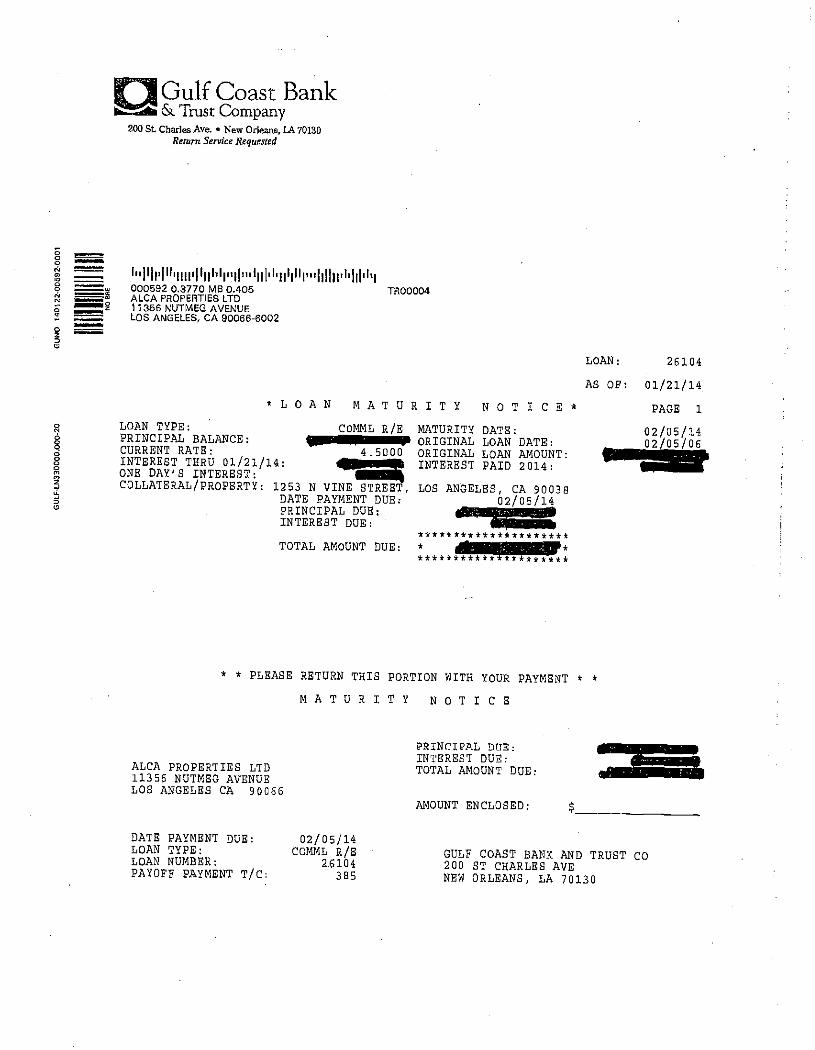
Gulf Coast Bank & Trust Company
200 St Charles Ave. New Orleans, LA 70130 Return Service Requested
ó = 1.1404010014.400,1004"1 0111
á 000592 0.3770 MB 0.405 n ALCA PROPERTIES LTD
8 11366 NUTMEG AVENUE LOS ANGELES, CA 90086 -$112 mamas
zz
TR00004
LOAN: 26104
AS OF: 01/21/14
* L O A N M A T U R I T Y N O T I C E* PAGE 1
LOAN TYPE: COMML R/E MATURITY DATE: PRINCIPAL BALANCE: gisimmimmi ORIGINAL LOAN DATE: CURRENT RATE: 4.5000 ORIGINAL LOAN AMOUNT: INTEREST THRU 01/21/14: INTEREST PAID 2014: ONE DAY'S INTEREST: COLLATERAL /PROPERTY: 1253 N VINE STREET,
DATE PAYMENT DUE: LOS ANGELES, CA 90038
02/05/14 PRINCIPAL DUE: INTEREST DUE:
* * * * * * * * * * * * * * * * * * * ** TOTAL AMOUNT DUE:
* * * * * * * * * * * * ** * * * * **
* * PLEASE RETURN THIS PORTION WITH YOUR PAYMENT *
M A T U R I T Y N O T I C E
ALCA PROPERTIES LTD 11356 NUTMEG AVENUE LOS ANGELES CA 9006G
DATE PAYMENT DUE: LOAN TYPE: LOAN NUMBER: PAYOFF PAYMENT T /C:
02/05/14 COMML R/E
2.6104 385
PRINCIPAL DUE: INTEREST DUE: TOTAL AMOUNT DUE:
AMOUNT ENCLOSED:
02/05/14 0
GULF COAST BANK AND TRUST CO 20D ST CHARLES AVE NEW ORLEANS, LA 70130
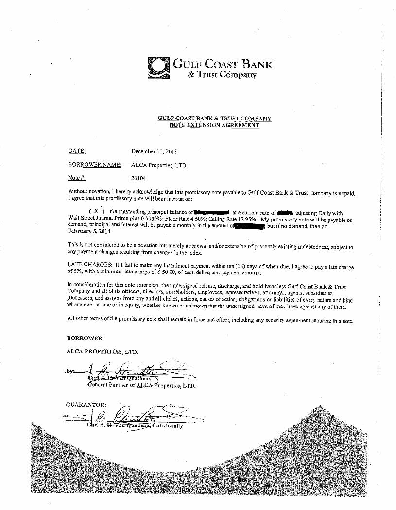
GULF COAST BANK Trust Company
GULF COAST BANK & TRUST COMPANY NOTE EXTENSION AGREEMENT
DATE: December 11, 2013
BORROWER NAME; ALCA Properties, LTD.
Note #: 26104
Without novation, I hereby acknowledge that this promissory note payable to Gulf Coast Bank & Trust Company is unpaid. I agree that this promissory note will bear interest on:
( X ) the outstanding principal balance of_ at a current rate oft adjusting Daily with Wall Street Journal Prime plus 0.5000 %; Floor Rate 4.50%; Ceiling Rate 12.95 %. My promissory note will be payable on demand, principal and interest will be payable monthly in the amount c , but if no demand, then on February 5, 2014.
This is not considered to be a novation but merely a renewal and/or extension of presently existing indebtedness, subject to any payment changes resulting from changes in the index.
LATE CHARGES: If I fail to make any installment payment within ten (15) days of when due, I agree to pay a late charge of 5 %, with a minimum late charge of $ 50.00, of each delinquent payment amount.
In consideration for this note extension, the undersigned release, discharge, and hold harmless Gulf Coast Bank & Trust Company and all of its officers, directors, shareholders, employees, representatives, attorneys, agents, subsidiaries, successors, and assigns from any and all claims, actions, causes of action, obligations or liabilities of every nature and kind whatsoever, at law or in equity, whether known or unknown that the undersigned have of may have against any of them.
All other terms of the promissory note shall remain in force and effect, including any security agreement securing this note.
BORROWER:
ALCA PROPERTIES, LTD.
lirfí1>< n . ..1,
ararIvïe! .? ná em,, eneral Partner of A_S,C.4-fsiroperties, LTD.

Gulf Coast Bank ® ôt Trust Company 200 St. Charles Ave. New Orleans, LA 70130
Return Service Requested
flI'l'I'lliilii IIIIPIqijljij
'l'IllI'IIhlllnyIIllIliI'j'Ii
00241 0.3770 WCL0001 ALCA PROPERTIES LTD 11356 NUTMEG AVENUE LOS-ANGELES, CA 90066 -6002
u
LOAN TYPE: PRINCIPAL BALANCE: CURRENT RATE: INTEREST THRU 11/20 ONE DAY'S INTEREST: COLLATERAL /PROPERTY
* L O A N M A T U C0 4.5000
/13:
: 1253 N VINE STREET, DATE PAYMENT DUE: PRINCIPAL DUE: INTEREST DUE:
TOTAL AMOUNT DUE:
R I T Y N O T I C E*
MATURITY DATE:. ORIGINAL LOAN DATE: ORIGINAL LOAN AMOUNT: INTEREST PAID 2013:
LOS ANGELES, CA 90038 12/05/13
OMIMMOMIO ********************* * *
*********************
LOAN: 26104
AS OF: 11/20/13
PAGE 1
* * PLEASE RETURN THIS PORTION WITH YOUR PAYMENT * *
ALCA PROPERTIES LTD 11356 NUTMEG AVENUE LOS ANGELES CA 90066
DATE PAYMENT DUE: LOAN TYPE: LOAN NUMBER: PAYOFF PAYMENT T /C:
M A T U R I T Y N O T I C E
12/05/13 COMML R/E
26104 385
PRINCIPAL DUE: INTEREST DUE: TOTAL AMOUNT DUE
AMOUNT ENCLOSED:
12/05/13 02/05 06
GULF COAST BANK AND TRUST CO 200 ST CHARLES AVE NEW ORLEANS, LA 70130

GULF COAST BANK & Trust Company
GULF COAST BANK & TRUST COMPANY NOTE EXTENSION AGREEMENT
DATE: October 5, 2013
BORROWER NAME: ALCA PROPERTIES, LTD.
Note #: 26104
Without novation, l hereby acknowledge that this promissory note payable to Gulf Coast Bank & Trust Company is unpaid. I agree that this promissory note wilt bear interest on:
( X' ) the outstanding principal balance of a at a current rate of T"1"t adjusting Daily with Wall Street Journal Prime plus 0.5000 %; Floor Rate 4.50 %; Ceiling Rate 12.95 %. My promissory note will be payable on demand, principal and interest will be payable monthly in the amount MIME= but if no demand, then on December 5, 2013.
This is not considered to be a novation but merely a renewal and/or extension of presently existing indebtedness, subject to any payment changes resulting from changes in the index.
LATE CHARGES: If 1 fail to make any installment payment within ten (15) days of when due, I agree to pay a late charge of 5%, with a minimum late charge of S 50.00, of each delinquent payment amount.
In consideration for this note extension, the undersigned release, discharge, and hold harmless Gulf Coast Bank & Trust Company and all of its officers, directors, shareholders, employees, representatives, attorneys, agents, subsidiaries, successors, and assigns from any and all claims, actions, causes of action, obligations or liabilities of every nature and kind whatsoever, at law or in equity, whether known or unknown that the undersigned have of may have against any of them.
All other terms of the promissory note shall remain in force and effect, including any security agreement securing this note.
BORROWER:
ALCA PROPERTIES, LTD.
eV By wynistarAM::.àte c Cr ivathem,
General Partner of ALCA Properties, LTD.
em, Individually

o z 7
Uhf -Coast Bank sar Cx Trust Company 200 St Charles Ave, New Orleans, LA 70130
Return Service Requested
IiI' l' 100, IIIIIPII1'1l1'11'l01'jIhPpi llj,IIliI'I'l' s. 00452 0.3770 WCL0001
ALCA PROPERTIES LTD 11356 NUTMEG AVENUE LOS ANGELES, CA 900 66 -600 2
* L O A N M A T U R I T Y N O T I C E* LOAN TYPE: COMML R/E PRINCIPAL BALANCE: CURRENT RATE: 4.5000 INTEREST THRU 09/22/13: ONE DAY'S INTEREST: COLLATERAL /PROPERTY: 1253 N VINE STREET,
DATE PAYMENT DUE: PRINCIPAL DUE: INTEREST DUE:
TOTAL AMOUNT DUE:
MATURITY DATE: ORIGINAL LOAN DATE: ORIGINAL LOAN AMOUNT: INTEREST PAID 2013:
LOS ANGELES, CA 90038 10/05/13
********************* * * *********************
LOAN: 26104
AS OF: 09/20/13
PAGE 1
* * PLEASE RETURN THIS PORTION WITH YOUR PAYMENT * *
ALCA PROPERTIES LTD 11356 NUTMEG AVENUE LOS ANGELES CA 90066
DATE PAYMENT DUE: LOAN TYPE: LOAN NUMBER: PAYOFF PAYMENT TIC:
M A T U R I T Y N O T I C E
10/05/13 COMML R/E
26104 385
10/05/13 02/05 06
PRINCIPAL DITE: SOS INTEREST DUE: TOTAL AMOUNT DUE:
AMOUNT ENCLOSED:
GULF COAST BANK AND TRUST CO 200 ST CHARLES AVE NEW ORLEANS, LA 70130

Exhibit "13"

Water. Boards
eOMUNV 3.2.4N dN Y ,OVflll,n
Los Angeles Regional Water Quality Control Board
July 11, 2014
Mr. Carl Van Quathem ALCA Properties 11356 Nutmeg Avenue Los Angeles, CA 90066
SUBJECT: RESPONSE TO A REQUEST FOR REVIEW OF THE FURTHER REVISED WORK PLAN DATED ON FEBRUARY 12, 2014
CASE /SITE: FOUNTAIN -VINE PLAZA, 1253 VINE STREET, HOLLYWOOD, CA (SITE CLEANUP PROGRAM NO. 1196, SITE ID NO. 2040235)
Dear Mr, Quathem:
The California Regional Water Quality Control Board, Los Angeles (Regional Board) is the lead agency with primary responsibility for the protection of groundwater and surface water quality within major portions of Los Angeles and Ventura counties. To accomplish this, The Regional Board oversees the investigation and cleanup ordischarges of waste that may affect the quality
- -.of -- waters -of the-state-as authorized. by- Control Act (California - Water Code, Division 7).
Regional Board staff have reviewed the report titled Further Revised Down- Gradient Assessment Work Plan (Work Plan), dated February 12, 2014, in response to a request made during a meeting with you and yoúr representatives on May 22, 2014. Please note that a response to the Work Plan had been provided qn March 3, 201,4 (attached). This letter replaces that letter. In response to your request fdr a further review, we have The following comments and revisions to the Work Plan:
1. 5'h Paragraph, Page 2: The proposed well screen diameter is one inch. Taking into consideration well integrity and sampling practices, well casing 'and the screen inner diameter must be at least 2- inches to assure that the well functions properly.
2. 6`" Paragraph, Page 2: The proposed well development procedure (3`d bullet) indicates that turbidity would be visually observed. Newly constructed wells must be developed Uhtil turbidity is stabilized, át 10 Nephéiometric Turbidity Units (NTUs), Groundwater samples must be collected at 10 feet below the water table.
3. 3`1 and 5'" Paragraphs, Page 3: Regarding MW4,. you stated, "As indicated in the work plan dated January 21, 2014, it is understood that if the PCE concentrations in MW4 are not appreciably higher than the concentrations found in the up- gradient groundwater beneath the site as encountered in MW2, the Board' will determine that the Fountain - Vine Plaza site is not a continuous source of PCE to the groundwater found under and in
GbfAlhBe 5'rrai:c _n, rnñin 9Arn@Ie tfiioen, ezecutlYe orrmen
320 Weu44tÌi 7t.r pull 100 l.On An InLLa CA 00'...n .,.......,...
. ..,.....-_......... (119 0 \44,ü/t1Uü!!IJ t4.1jUY/106e IgtllltY
1.'0.6;4 OAVry'

Mr. Carl Van Quathem - 2 - July 11, 2014 ALCA Properties, Ltd.
the immediate vicinity of the Fountain -Vine Plaza site or adjacent properties, and will therefore issue a "No Further Action" or "NFA" letter to the Fountain -Vine Plaza owner for thatproperty..; If elevated concentrations of PCE are observed in proposed well no. MW4:ihdicating the potential ëxistence Of á separate pligne cörning off the Fountain -Vine site of such. significance that would justify the need, for any further action on the Fourtein -Vine site, AA&A requests further discussion with the LARWQCB staff before anyadditional decisions regarding the, site are made;"
Response: Your Work Plan proposes that the Regional Board use the results of monitoring the newly proposed well MW4 to make a final determination as to whether the Regional Board should issue an NFA letter: It maybe likely that the.plume beneath and downgradient of the Fountain-Vine Plaza site consists of commingled discharges from that site and the Paragon Cleaners site. There are not sufficient data currently available regarding PCE in The groundwater found under and in the immediate vicinity of the Fountain -Vine Plaza site and adjacent properties to determine whether the Fountain - Vine Plaza site is a continuing source of PCE to the groundwater. The Regional Board agrees that data from MW4 will be helpful in further characterizing the PCE plume. However, such data are not likely to be sufficient themselves to make an NFA determination. Additional data.may be needed to better evaluate your NFA request. The Regional. Beard will use water quality data from MW4 and other information available regarding, the site, including the existing data, the joint monitoring you propose, and data suggested in the response in Paragraph 4 .below to determine a no further action is appropriate.
It is not clear what you mean by "potential existence of a separate plume ..: of such significance ". The Regional Board is certainly willing to further discuss the site with -AA &A following ëGaluátlon of thé datä:cöllëctéd fröm MW4.
4. 4`h Paragraph, Page 3: You stated, "The only purpose of MW5 is to look for PCE and compare the concentration to the. levels found at the up- gradient Paragon Cleaners site and for the Board staff to make future cleanup decisions regarding the Paragon Cleaners site. The newly proposed MWS well location is not believed to be down - gradient from the Fountain -Vine site, and for this reason, the sampling results from this proposed well will not affect any decision on closure or the issuance of a NFA letter involving the Fountain -Vine site. Therefore, any detection of PCE reported in samples collected from well MW5 will not affect a case closure decision for the Fountain -Vine Plaza case."
Response: Regional Board staff does not agree that the data from the newly proposed MW5 will not affect a decision on the need for further action at the Fountain -Vine Plaza site. The proposed well MW5 is about 90 feet cross -gradient from the locations of the April 2013 beriñg" 332 and existing wëll MW3. The.bbring B32 and the well MW3 detected the highest PCE concentration in groundwater of 7,790 pg /L and 1,460 pg /L, 'respectively. The lateral delineation of the plume at the boring B32 and.the well MW3 has not been fully assessed. We do not have sufficient information 'to decide at this time whether' any chemical detection from MW5 is not related to the FVP site.
Regional Board staff re- evaluated the purpose of MW5, and recommend that you not install MW5 because installatipn of MW5 will only :serve to further delineate the downgradient portion of the contaminated groundwater plume. Instead of installing
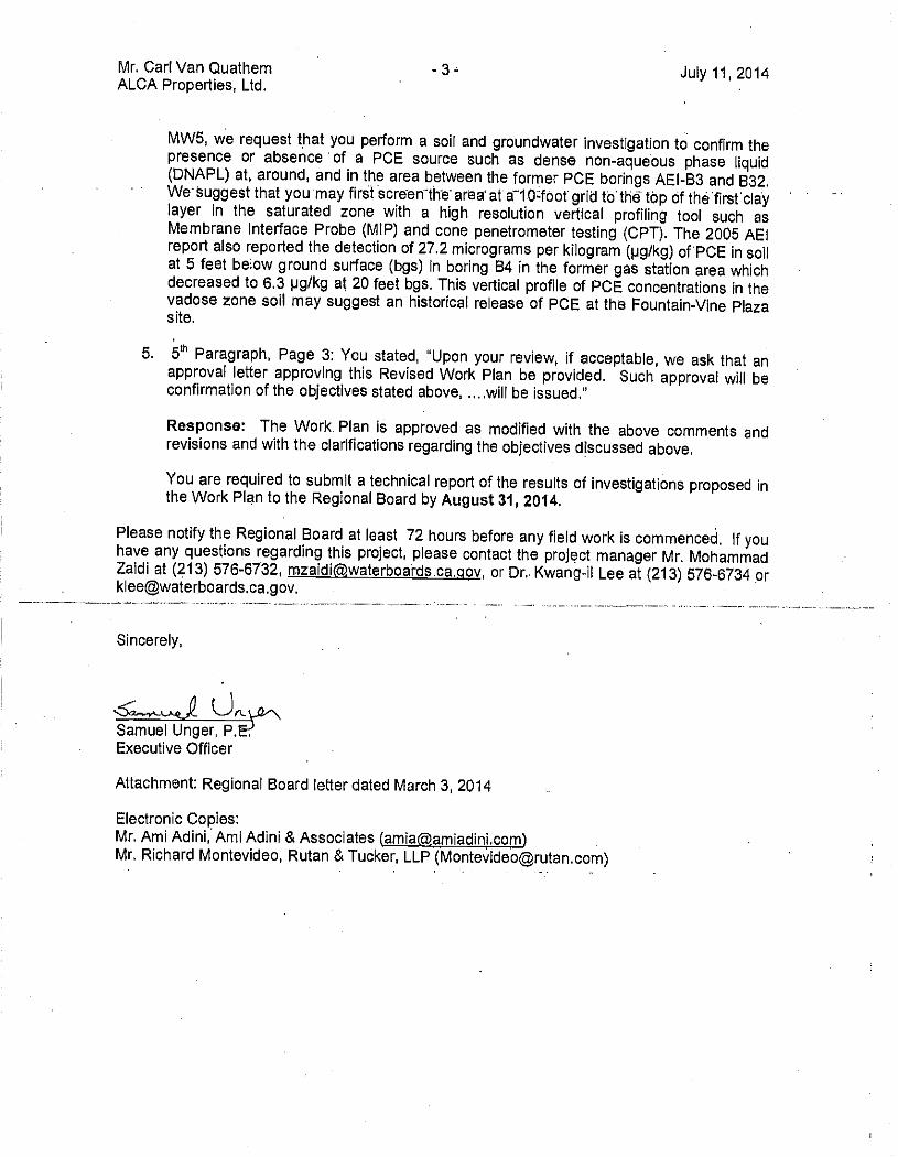
Mr. Carl Van Quathem - 3 - July 11, 2014 ALCA Properties, Ltd.
MW5, we request that you perform a soil and groundwater investigation to confirm the presence or absence ' of a PCE source such as dense non -aqueous phase liquid (DNAPL) at, around, and in the area between the former PCE borings AEI -B3 and B32. We'suggestthat you may first screen-the" area' atal 0;footi grid toi the top of the first clay layer in the saturated zone with a high resolution vertical profiling tool such as Membrane Interface Probe (MIR) and cone penetrometer testing (CPT). The 2005 AEI report also reported the detection of 27.2 micrograms per kilogram (pg /kg) of 'PCE in soil at 5 feet below ground surface (bgs) In boring B4 in the former gas station area which decreased to 6.3 pg /kg at 20 feet bgs. This vertical profile of PCE concentrations in the vadose zone soil may suggest an historical release of PCE at the Fountain -Vine Plaza site.
5. 51h Paragraph, Page 3: You stated, "Upon your review, if acceptable, we ask that an approval letter approving this Revised Work Plan be provided. Such approval will be confirmation of the objectives stated above, ....will be issued."
Response: The Work Plan is approved as modified with the above comments and revisions and with the clarifications regarding the objectives discussed above.
You are required to submit a technical report of the results of investigations proposed in the Work Plan to the Regional Board by August 31, 2014.
Please notify the Regional Board at least 72 hours before any field work is commenced. If you have any questions regarding this project, please contact the project manager Mr, Mohammad Zaidi at (213) 576 -6732, mzaidina,waterboards.ca.aov, or Dr. Kwang -il Lee at (213) 576 -6734 or [email protected].
Sincerely,
Samuel ger, PM1I
Executive Officer
Attachment: Regional Board letter dated March 3, 2014
Electronic Copies: Mr. Ami Adini, Ami Adini & Associates (amiaCäamiadini.com) Mr. Richard Montevideo, Rutan & Tucker, LLP ([email protected])
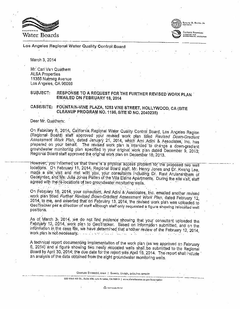
Water. Boards
B:mem
edm+xcw Bncemunx
'wñóeúñirii rrorem,on
Los Angeles Regional Water Quality Control Board
March 3, 2014
Mr Carl Van Quathem ALSA Properties 11356 Nutmeg .Avenue Los Angeles, CA 90066
SUBJECT: R,ESPONSETO A REQUEST FOR THE FURTHER REVISED WORK PLAN SAILED ON FEBRUARY18,2014
CASE./SITE: FOUNTAIN-VINE PLAZA,. 1253 VINE STREET, HOLLYWOOD, CA (SITE CLEANUP PROGRAM. NO. 1195i SITE 1D NO. 2040235)
Dear Mr, Quáthem:.
On February 6, 2014, California; Regional Water Quality Control Board, Los Angeles Region (Regional Board) staff approved your revised work plan titled Revised Down -Gradient Assessment Work Plan,. dated January 21, 2014, which Ami:Adinii & Associates, Inc, has prepared, on your behalf. The revised work plan Is intended to change a down- gradient groundwater monitoring plan specified 1n your original, .work plan dated December 9, 2013; Regional Beard staff approved the original Work plan on December 18,, 2013.
However, you- infórmed:us that- thereísa physical access pföblémlar the proposed two well locations: On. February 11; 20141, Regional Board staff, Mr: Henry Jones and Dr,Kwang Lee, made a site visit and met with you,, your ,consultants 'Including Dr. Ravi Arulanantham of Geosÿntec, and Ms Julia Jones Patten of the Ville Elaine Apartments,: During the site visit, staff agreed with the re- locations of two groundwater, monitoring Wells,
On February 18; 2014, your consultant, Ami &:Associates,, Inc. emailed another revised , work Olen titled, Further Revisad:Down- Gradient Assessment Work Plan; dated February' 12, 2014, tome, and asserted that'on February 13, 2014, -the revised work plan was Uploaded. to Geotrackér per a direction of staff although staff only requested e figure showing relocated well positions.
As of. March 3, 2014, we do not ,find evidence showing that your consultant uploaded the February 12; 2014, work plan to Geq.Tracker, Based on information submitted, and on the, information in the case file, we have determined`that another review of the February 12, 2014, work plan Is ndt;nécéssary ..... . A technical report documenting implementation of the work plan (as we appróyed on February 6, 20:14) and à figure showing two newly relocated wells shall :be submitted to the Regional Board by April 30, 2014; the due date for the report was April 15, 2014; The report shall include an analysis of the data obtained from the bight groundwater monitoring wells.
Cluraeo arn,lcu(, comp 1
5nuueu Uuaeh t cui;vc opn ci
no We; st 411 St., Bulle 200, Lou AnOelee, CA 00013 I wive .Wolerbonres,coOovj,onn0elov

Mr. Carl Van Quathem - 2 - March 3, 2014 ALSA Properties, Ltd.
If you have any questions regarding this project, please contact me at (213) 576 -6734 or klee©waterboards.ca.gov
Sincerely,
Kwang -il Lee, Ph. D., P.E. Site Cleañup Program Unit IV Chief
Electronic Copies: Mr, Ami Adini, Ami Adini & Associates (amia @amiadini.com)

Exhibit "14"
Water Boards
EDMUND O. Snows Jo. coveneon
MAT1New Roonmuot DOC NOTARY ron
wnOnl en1AL 15001ecrmN
Los Angeles Regional Water Quality Control Board
September 17, 2014
Mr. Carl Van Quathem ALCA Properties 11356 Nutmeg Avenue Los Angeles, CA 90066
SUBJECT: SUMMARY OF-THE AUGUST 13, 2014 MEETING REGARDING REGIONAL BOARD REQUIREMENTS FOR SOIL AND GROUNDWATER INVESTIGATION TO CONFIRM THE PRESENCE OR ABSENCE OF PCE SOURCE IN EASTERN PORTION OF FOUNTAIN VINE PLAZA SITE
CASE /SITE: FOUNTAIN -VINE PLAZA, 1253 VINE STREET, HOLLYWOOD, CA (SITE CLEANUP PROGRAM NO. 1196, SITE ID NO. 2040235)
Dear Mr. Quathem:
In a letter to you, dated July 11, 2014, the California Regional Water Quality Control Board, Los Angeles (Regional Board) approved your proposed wprk plan, with some modifications, and requested that you complete certain additional tasks to investigate soil and groundwater at the above -referenced site and submit a technical report, containing the results of the investigation by August 31, 2014. The Regional Board has, to date, not received the technical report.
Regional Board staff members - Mr. Mohammad Zaidi and Mr. Jeff Brooks - had a meeting on August 13, 2014 with Mr. Ravi Arulanantham and Mr. Syed Rehan of your consultant Geosyntec. On your behalf as the responsible party for the Fountain Vine Plaza (FVP) site, Mr. Arulanantham had requested the meeting to discuss the details of the work requested in the Regional Board's July 11, 2014 letter and requested reductions in the number and locations of the Membrane Interface Probe (MIP) borings and collection and analysis of verification soil samples. As explained at the August 13 meeting, these MIP borings should be completed through the vadose and saturated zone to the top of the first clay layer in the 'saturated zone and should be used along with the analytical results of verification soil samples to confirm the presence or absence of the tetrachioroethylene (PCE) source in the area between former borings AEI -B3 and B32 at the Fountain -Vine Plaza site,
Following is a summary, and clarification of the agreement reached in the August 13, 2014 meeting:
1. You, the responsible party, will complete two borings, up to 10 feet apart, through the vadose zone and first saturated zone to a total depth of at least 80 feet below ground surface (bgs), at each of two groundwater volatile organic compound (VOC) hot spots, first at AEI -B3 [PCE 4,700 micrograms per liter (ug /L)] and second at B -32 [PCE 7,790 ug /L], by using a cone penetrometer testing (CPT) equipment to define the soil lithology
CHARLES STRIN3IIR, GRAM I SAMUEL UNGER. GYCOUrIvE OFFICCfi
320 West 4th SI.. Suite 200, Los Angeles, CA 90013 I www .weteihoerdo.ce.gov /Iosengeles.
¿ Nccvcwwo

Mr. Carl Van Quathem - 2 - September 17, 2014 ALCA Properties
and the MIP to identify any volatile organic compounds (VOCs) in the soil. Of the four borings, each will terminate at a total depth of at least 80 feet bgs or at the top of and one foot into a play layer (below the water table for the'first saturated zone). To reiterate, two borings, up to 10 feet apart, will be completed to a depth of at least 80 feet bgs or to a depth of one foot into a clay layer at AEI -B3, and two borings, up to 10 feet apart, will be completed to a depth of at least 80 feet bgs or to a depth of one foot into a clay layer at B -32. After review of each of the four MIP logs (one from each of the four boreholes), depths at which VOC peaks are identified in each of the MIP logs completed in both the vadose and saturated zones will be marked, and verification soil matrix samples will be collected from those depths for laboratory analysis using USEPA Method 8260B.
2. The Regional Board requests that you submit to the Regional Board the technical report addressing Item 1 and other actions set forth in the Regional Board's July 11, 2014 letter by October 30, 2014.
If you have any questions regarding this project, please contact the project manager Mr. Mohammad Zaidi at (213) 576 -6732, mzaidi(cïlwaterboards.ca.gov, or Dr. Kwang -il Lee at (213) 576 -6734 or klee ©waterboards.cá.gov,
Sincerely,
Samuel Unger, R Executive Officer
Mr. Ami Adini, Ami Adini & Associates (amia(aamiadini.com) Mr. Richard Montevideo, Rutan & Tucker, LLP (Montevideo(a)rútan.com) Mr. Ravi Arulanantham, Geosyntec Mr. Syed Rehan

Exhibit "15"

Geosyntec' consultants
Memorandum
Date: 10 October 2014
To: Carl Van Quathem, ALCA Properties, Ltd.
11 I1 Broadway, 6th Floor Oakland, California 94607
PH 510.836.3034 FAX 510.836.3036
www.oeosynteccgm
Copies to: Richard Montevideo, Rutan & Tucker, LLP
From: Ravi Arulanantham, Syed Rehan, P.E., and KarinaNavatro, P.E, Geosyntec Consultants
Subject: Purpose of Additional Investigation Fountain -Vine Plaza 1253 Vine Street, Los Angeles, California, 90028 LARWQCB Case No. 1196
ALCA Properties, Ltd. (ALGA) has been working with the Regional Board since 2006 to obtain closure for the above referenced Fountain -Vine Plaza property Each investigation effort has yielded information on the distribution of PCE in the site area, The results of these investigations have reflected an insignificant release of PCE from the former dry- cleaner on the property, which ceased operations in or about 1970 [AEI, 2005]. Despite the detailed information already collected for the site, the Regional Board has continued to request additional costly investigations. In this Technical Memorandum, we discuss the information that site investigations have yielded to date and the technical purpose of the most recently requested additional investigation, as reflected in the Regional Board' s letters of July 11 and September 17, 2014 (requesting four MIP /CPT borings down to 80' below the ground surface (bgs)).
1. BACKGROUND
The stated primary objective in the Regional Board's July 11, 2014 letter was for ALCA to conduct further work to confirm "the presence or absence of a PCE source such as dense non - aqueous phase liquid ( DNAPL) at, around, and in the area between the former PCE borings AEI -B3 and B32." Because of the Regional Board's newly asserted concerns with the possibility of DNAPL from prior operations on the property, ALCA is now being asked to "screen the area at a 10 foot grid to the top of the first clay layer in the saturated zone with a high resolution vertical profiling tool such as Membrane Interface Probe (MTP) and cone penetrometer testing (CPT). The 2005 AEI report also reponed the detection of 27.2 micrograms per kilogram (pg/kg) of PCE in soil at 5 feet below ground surface (bgs) in boring FV Memo. docx
engineers I Sdentists.' innovators

Purpose of Additional Investigation 10 October 2014 Page 2
B4 in the former gas station area which decreased to 6.3 pg/kg at 20 feet bgs. This vertical profile of PCE concentrations in the vadose zone soil may suggest an historical release of PCE at the Fountain -Vine Plaza site."
In light of the Regional Board's stated concerns with DNAPL, in its September 17 letter it requested that "two borings, up to 10 feet apart, will be completed to a depth of at least 80 feet bgs or to a depth of one foot into a clay layer at AEI -133, and two borings, up to 10 feet apart, will be completed to a depth of at least 80 feet bgs or to a depth of one foot into a clay layer at B- 32. After review of each of the four MIP logs (one from each of the four boreholes), depths at which VOC peaks are identified in each of the MIP logs completed in both the vadose and saturated zones will be marked, and verification soil matrix samples will collected from those depths for laboratory analysis using USEPA Method 8260.B."
2. SOIL AND SOIL VAPOR DATA
We reviewed the borings results, including the soil, soil vapor, and groundwater results in an attempt to identify the cause for. the Regional Board's suggestion that DNAPL or other PCE source is present at the site. Both the concentration values themselves and their concentrations relative to samples at other depths were evaluated, as discussed below.
Based on our review of the data generated to date involving the site, including the prior approximately 30 borings, it is Geosyntec's conclusion that the PCE concentrations in soil and soil vapor and their depth profile show no indication of the existence of DNAPL from prior operations at the site.
The Regional Board has never previously suggested that DNAPL may be present at the site until recently, even though they have been overseeing the site work since 2006. To the contrary, it has been reported to Geosyntec that Regional Board staff has repeatedly advised ALCA that, at a minimum, the Regional Board is prepared to issue a soil -only no further action letter for the site. The Regional Board's change of plan does not appear to be based on recent data collected for the site. As explained below, the evidence does not support the existence of DNAPL at the Fountain -Vine site.
The profile of soil vapor PCE concentrations is an indicator of the source of PCE. Because PCE is highly volatile, high concentrations are typically present in the air around a liquid or sorbed source. Expected PCE profiles in soil vapor caused by continuous sources would be as follows:
Source in soil: highest concentrations at depths near the source in the soil, possibly maintaining high concentrations for some distance below the source due to vertical migration.
FPMemo.docs
engineers I scientists I innovators

Purpose of Additional Investigation 10 October 2014 Page 3
Source at ground surface: highest concentrations near the ground surface, with the concentrations decreasing with depth. As in sources in soil, PCE concentrations may remain elevated for some distance below the source due to migration.
Source in groundwater: highest concentrations in the soil vapor immediately above the groundwater, with concentrations increasing from the surface to the water table.
The tables below summarize the soil vapor PCE concentrations at the Fountain -Vine site and, for comparison, the Paragon Cleaners site. At the Fountain -Vine site, the highest PCE concentrations consistently occur close to groundwater (27.5 to 30 ft bgs). The PCE concentrations increase with depth, such that the PCE concentrations near the water table are orders of magnitude higher than at shallower depths. The profile of PCE beneath the Fountain - Vine site is consistent with PCE volatilizing from the groundwater. In contrast, concentrations of PCE at the Paragon Cleaners site is typically the same order of magnitude across borehole depths, and in some cases decreases with depth. This PCE profile is more consistent with a source at the ground surface. The high concentrations of PCE in the sub -slab samples at the Paragon Cleaners site further indicate a surface source at Paragon Cleaners.
FVMemo.docx
engineers I scientists I innovators
Purpose of Additional Investigation 10 October 2014 Page 4
Fountain -Vine Site r
Borehole Depth PCE
(trgPL)
[PCE]/ [PCE,
shallow] 5 3.19
B -22 15 7.96 2 25 29.4 9 5 0.684
B -24 15 29.4 43 25 208 304 5 0.01
B -28 15 10.6 1,060 25 24.1 2,410 5 0.01
B -31 15 16 1,600 25 21.1 2,110 5 2.1
B -32 15 18.3 9 25 74.2 35 5 0.02
B -33 15 16,1 805 25 289 14,450
Paragon Cleaners Site 2
PCE [PCE]/ Borehole Depth
fgg/L) [PCE,
shallow]
SG -1 5
25 140 290 2
SG -2 sub -slab 2600 5 2100 0,8
SG -3 sub -slab 1500 5 920 0.6
SG -4 5 1600 25 180 0,1
SG -5 5 37 25 330 9
SG -6 sub -slab 29 5 190 7
50-7 5 22 25 81 4
SG -8 sub -slab 16 5 37 2
Similar to soil vapor, the profile of PCE concentrations in soil is an indicator of the source of PCE. For soil contamination to be a source to groundwater, very high concentrations of the contaminant must be present. A moderate -to- highly hydrophobic contaminant like PCE tends to sorb strongly to the soil, particularly where there is a high fraction of fines. This reduces the tendency of PCE to move downward through the soil. If a surface source were currently present, there would be PCE concentrations in the range of thousands of micrograms per kilogram (1 ppm or higher). If the surface source at the subject site had stopped adding to the contamination decades ago, the highest concentrations of PCE would be further down in the soil, but there would continue to be a trail of elevated concentrations from the surface to the hot spot and a leading edge of the contamination below the hot spot. In the silty soil present in the upper soil at the Fountain -Vine site, we would expect to see at least hundreds of micrograms of PCE per kilogram still in the surface soil if there had been a significant PCE surface release,
Data from AA &A, 2013. Only boreholes with at least 20 pg/L PCE at one or more depths is shown to provide a concentration profile, 2 Data from Iris Environmental, 2008.
FY Memo. docx
engineers I scientists I innovators
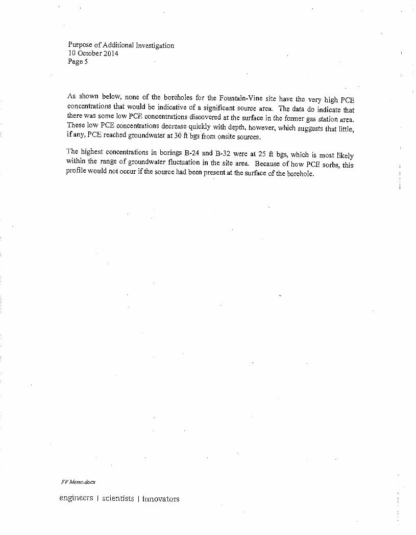
Purpose of Additional Investigation 10 October 2014 Page 5
As shown below, none of the boreholes for the Fountain -Vine site have the very high PCE concentrations that would be indicative of a significant source area. The data do indicate that there was some low PCE concentrations discovered at the surface in the former gas station area. These low PCE concentrations decrease quickly with depth, however, which suggests that little, if any, PCE reached groundwater at 3d ft bgs from onsite sources.
The highest concentrations in borings B -24 and B -32 were at 25 ft bgs, which is most likely within the range of groundwater fluctuation in the site area. Because of how PCE sorbs, this profile would not occur if the source had been present at the surface of the borehole.
FV Memo.docx
engineers I scientists I innovators

Purpose of Additional Investigation 10 October 2014 Page 6
Dry Cleaning Area3
Borehole Depth PCE
(lrg/kg) 5 3.3J
to <1
B -23 15 <1
20 <1
25 <1
5 2J 10 <1
B -25 15 <1
20 <1
25 <1
5 5.5
B -27 15 <1
25 <1
5 8.2
10 3.6J
B -29 15 <1
20 <1
25 <1
Gas Station Area
Borehole Depth PCE
(µg /kg)
AEI -B3 2 12.6
10 7.4
5 27.2
10 11.7 AEI -B4
15 5.9
20 6.3
5 5.9
10 <1
B -24 15 <1
20 <1
25 11
5 <1
10 2.8J B -28 15 <1
20 <1
25 <1
5 3.31
10 <1
B -32 15 <1
20 <1
25 <1
Other Areas Onsite
Borehole Depth PCE
(µg /kg) 5 8.9
10 <1
B -26 15 <1
20 <1
25 <1
5 <1
10 <1
B -32 15 <1
20 <1
25 13.9
As evident from the attached soil sampling results, the Fountain -Vine site has been sampled with a high density of soil borings, with depths from 5 to 25 feet bgs. No soil sample results carne close to the Industrial Screening Level (110,000 gg /kg) in the numerous soil sample borings, nor the Residential Screening Level (22,000 mg/kg). If there were a significant PCE source at the ground surface or in the soil onsite, there would be evidence of it in the fine- grained shallow soil. Instead, approximately 30 boreholes have shown no indication of a PCE source of any significance onsite. For these reasons, Geosyntec does not believe there is a technical basis to conclude that DNAPL exists as a result of prior operations on the Fountain -Vine site.
7 Data from AEI, 2005 and AA &A, 2013. Only boreholes with PCE concentrations above the detection limit are shown. Data from the other boreholes are attached.
FYMema.docx
engineers I scientists I innovators
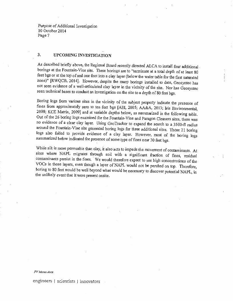
Purpose of Additional Investigation 10 October 2014 Page 7
UPCOMING INVESTIGATION
As described briefly above, the Regional Board recently directed ALCA to install four additional borings at the Fountain -Vine site. These borings are to "terminate at a total depth of at least 80 feet bgs or at the top of and one foot into a clay layer (below the water table for the first saturated zone)" [RWQCB, 2014]. However, despite the many borings installed to date, Geosyntec has not seen evidence of a well -articulated clay layer in the vicinity of the site. Nor has Geosyntec seen technical bases to conduct an investigation on the site to a depth of 80 feet bgs.
Boring logs from various sites in the vicinity of the subject property indicate the presence of fines from approximately zero to ten feet bgs [AEI, 2005; AA &A, 2013; Iris Environmental, 2008; ICCE Matrix, 2009] and at variable depths below, as summarized in the following table. Out of the 26 boring logs examined for the Fountain -Vine and Paragon Cleaners sites, there was no evidence of a clear clay layer. Using GeoTracker to expand the search to a 3500 -ft radius around the Fountain -Vine site generated boring logs for three additional sites, Those 21 boring logs also failed to provide evidence of a clay layer. However, most of the boring logs summarized below indicated the presence of some type of fines near 30 feet bgs.
While silt is more permeable than clay, it also acts to impede the movement of contaminants. At sites where NAPL migrates through sail with a significant fraction of fines, residual contaminants persist in the fines. We would therefore expect to see high concentrations of the VOCs in those layers, even though a layer of NAPL would not be perched on top. Therefore, boring to 80 feet would be well beyond what would be necessary to discover potential NAPL, in the unlikely event that it were present ensile.
FV Memo.dorx
engineers I scientists I innovators
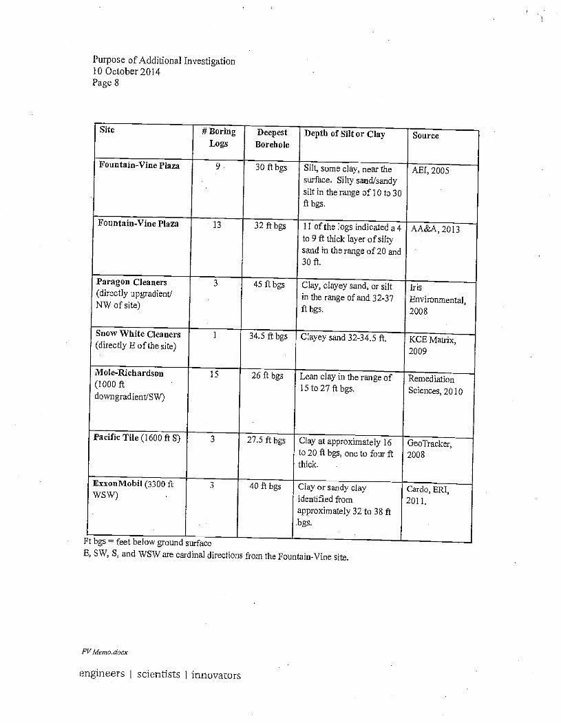
Purpose of Additional Investigation 10 October 2014 Page 8
Site # Boring Logs
Deepest Borehole
Depth of Silt or Clay Source
Fountain -Vine Plaza 9 30 ft bgs Silt, some clay, near the surface. Silty sand/sandy silt in the range of 10 to 30 ft bgs.
AEI, 2005
Fountain -Vine Plaza 13 32 ft bgs 11 of the logs indicated a 4 to 9 ft thick layer of silty sand in the range of 20 and 30 ft.
AA &A, 2013
Paragon Cleaners (directly upgradient/ NW of site)
3 45 ft bgs Clay, clayey sand, or silt in the range of and 32-37 ft bgs.
Iris
Environmental, 2008
Snow White Cleaners (directly E of the site)
1 34.5 ft bgs Clayey sand 32 -34.5 ft. KCE Matrix, 2009
Mole- Richardson (1000 ft
downgradient/SW)
15 26 ft bgs Lean clay in the range of 15 to 27 ft bgs.
Remediation Sciences, 2010
Pacific Tile (1600 ft S) 3 27.5 ft bgs Clay at approximately 16
to 20 ft bgs, one to four it thick,
GeoTracker, 2008
ExxonMobil (3300 ft WSW)
3 40 ft bgs Clay or sandy clay identified from approximately 32 to 38 ft bgs.
Cardo, ERI, 2011.
Ft bgs = feet below ground surface E, SW, S, and WSW are cardinal directions from the Fountain -Vine site.
FV Memo.dorx
engineers 1 scientists 1 innovators

Purpose of Additional Investigation 10 October 2014 Page 9
4. SUMMARY AND CONCLUSIONS
Geosyntec has examined the data provided by past site investigations, and finds no evidence to suggest that DNAPL is present at the Fountain -Vine site from prior site operations. The PCE distribution in the soil and soil gas at the Fountain -Vine site has been well defined by samples extending from near the surface to near groundwater. These past investigations have not shown evidence of a significant PCE source in the onsite soil, and therefore no evidence of DNAPL.
It would be very odd to find a significant PCE source from a gas station operation. Although gas stations may use minimal quantities of degreasers, it would not have been enough to produce a DNAPL plume. Additionally, the gas station on site reportedly operated from 1925 to 1928 [AA &A, 2012], and PCE was first produced in the United States in only 1925 [ASTDR, 2011].
The former dry- cleaner operations on the site (reportedly operating from 1955 to 1970), is not in the area of where the Regional Board is currently requesting an investigation of the site for purposes of determining the existence of DNAPL on the site. Both the Sanborn, 1957 and the AEI, 2006 maps place the former dry cleaning facility approximately 35 feet west of the former gas station area, and therefore, cross -gradient from the area in question for the requested four MIP /CPT locations, and cross -gradient from the Paragon Cleaner's site.
The collective data from the site and the upgradient Paragon Cleaner's site indicates that the most likely source of the PCE detected in the groundwater and soil /soil vapor above the groundwater on the Fountain -Vine site is the Paragon Cleaner's site, and not the former gas station or dry cleaner operations on the Fountain -Vine site. The soil vapor concentration profile, which increases with depth, is consistent with the onsite PCE contamination coming up from the groundwater due to an upgradient offsite source.
To the extent any further borings can be shown to be warranted at the site, depths for the Regional Board requested borings should be based on where fines are present or the depth to groundwater, Residual DNAPL would persist in fine soil like silt and clay, and so would be reflected by high PCE concentrations in those layers. Below groundwater, the source of the PCE would become less clear, but, given the existing data, it would be much more likely to have migrated to the Fountain -Vine site from an upgradient source area such as the Paragon Cleaner's site. Layers of fines have been indicated near the ground surface and at approximately 20 to 30 feet bgs at the Fountain -Vine site, and groundwater has been measured between 27.5 and 30 feet bgs. Therefore, there is no reason to extend the boreholes significantly beyond 30 feet bgs.
We recommend that, assuming ALCA is agreeable, to proceed with further investigation on the site, the boreholes be advanced no deeper than 50 feet bgs. This depth would capture any layers of fines around 30 feet, and proceed 20 feet into the groundwater. Anything deeper than 50 feet
F<<Memo.docx
engineers I scientists I innovators