Embed Size (px)
Citation preview
St. Michael Elementary
www.curriculummapper.com 1 of 21
Grade 4 Social Studies Teacher: Renee Krupke
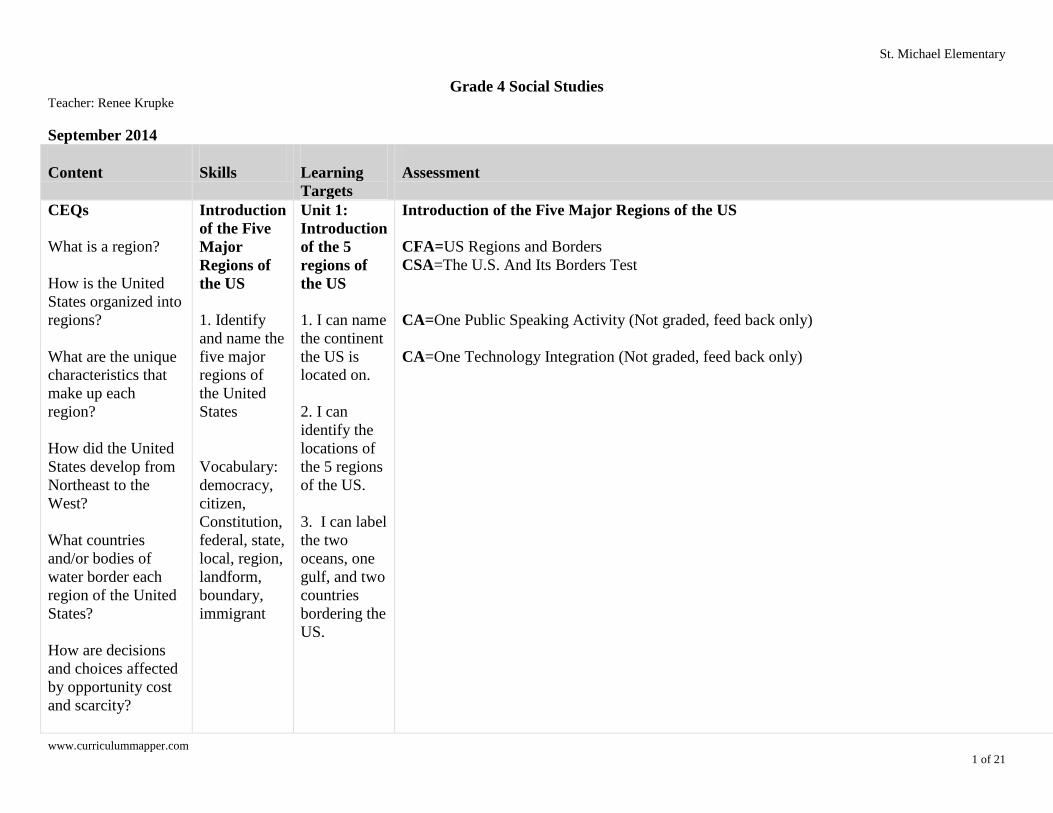
September 2014
Content
Skills
Learning
Targets
Assessment
Resources &
Technology
CEQs
What is a region?
How is the United
States organized into
regions?
What are the unique
characteristics that
make up each
region?
How did the United
States develop from
Northeast to the
West?
What countries
and/or bodies of
water border each
region of the United
States?
How are decisions
and choices affected
by opportunity cost
and scarcity?
Introduction
of the Five
Major
Regions of
the US
1. Identify
and name the
five major
regions of
the United
States
Vocabulary:
democracy,
citizen,
Constitution,
federal, state,
local, region,
landform,
boundary,
immigrant
Unit 1:
Introduction
of the 5
regions of
the US
1. I can name
the continent
the US is
located on.
2. I can
identify the
locations of
the 5 regions
of the US.
3. I can label
the two
oceans, one
gulf, and two
countries
bordering the
US.
Introduction of the Five Major Regions of the US
CFA=US Regions and Borders
CSA=The U.S. And Its Borders Test
CA=One Public Speaking Activity (Not graded, feed back only)
CA=One Technology Integration (Not graded, feed back only)
Introduction
of the Five
Major
Regions of
the US SF - Unit 1
Chapter 1
Lesson 1
SF - US
Region Map
Public
Speaking
Rubric in
shared folder

Krupke Grade 4 Social Studies St. Michael Elementary
www.curriculummapper.com 2 of 21
Content
Skills
Learning
Targets
Assessment
Resources &
Technology
Why may it be
important to save
money?
How does a market
economy answer
what gets produced,
how it is produced,
and who receives it?
UEQs: Introduction
of the Five Major
Regions of the US
What are the five
major regions of the
United States?
What are the
countries and bodies
of water that border
the United States?
Introduction of the
Five Major Regions
of the US
1. Northeast,
Southeast, Midwest,
Southwest, and West

Krupke Grade 4 Social Studies St. Michael Elementary
www.curriculummapper.com 3 of 21
Content
Skills
Learning
Targets
Assessment
Resources &
Technology
2. Canada, Mexico,
Atlantic Ocean,
Pacific Ocean, and
Gulf of Mexico
October 2014
Content
Skills
Learning Targets
Assessment
Resources &
Technology
UEQs: Northeast Region
What states make up the
Northeast Region?
What are the main landforms
of the Northeast Region?
Why did cities grow near
harbors?
What are the three levels of
government and the purpose
of each level?
Who is responsible for
running each level of
government?
Northeast Region
1. ME, VT, NH, MA, CT, RI,
Northeast Region
Match the level of
government to its function.
Match the location of each
state in the Northeast
Region and also write each
state's abbreviation.
Locate and/or name the
landforms of the
Northeast: Appalachian
Mountains Range, Niagara
Falls, Atlantic Ocean,
Chesapeake Bay, Lake
Erie, and Lake Ontario
Identify what affected the
growth of major
cities: Resources, waterways,
immigration, transportation,
Unit 2: Northeast
Region
1. I can locate the 11
states of the NW Region
on a region map.
2. I can label the 11
states with their
abbreviations of the NW
Region on a region map.
3. I can name the main
landforms of the NW
Region.
4. I can give the reason
why New York City,
NY; Boston, MA; and
Philadelphia, PA became
major cities in the NW
Region.
Northeast Region
ABBREVIATIONS &
LOCATIONS:
CFA=NE Region Formative
Assessment
CSA=NE Region Map Test
LANDFORMS: CFA=NE Landform
Formative Assessment
CSA=NE Landform
Assessment
UNIT TEST:
CFA=Strive for Success on
NE Test
CSA=Northeast Region Test
Northeast Region
SF - NE Region Map
SF - Unit 1 Chapter 2
Lesson 2
SF - Unit 2 Chapter 4
Lessons 1,2,3
SF - Unit 2 Chapter 5
Lessons 2,4
If Your Name Was
Changed at Ellis Island-
(Read-a-loud)
Scott Foresman Level
Readers (Complete
Main Idea Worksheet
with appropriate student
level)
Krupke Grade 4 Social Studies St. Michael Elementary
www.curriculummapper.com 4 of 21
Content
Skills
Learning Targets
Assessment
Resources &
Technology
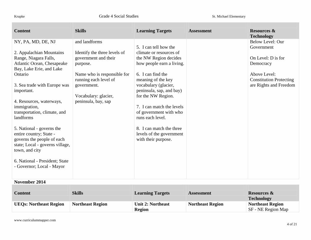
NY, PA, MD, DE, NJ
2. Appalachian Mountains
Range, Niagara Falls,
Atlantic Ocean, Chesapeake
Bay, Lake Erie, and Lake
Ontario
3. Sea trade with Europe was
important.
4. Resources, waterways,
immigration,
transportation, climate, and
landforms
5. National - governs the
entire country; State -
governs the people of each
state; Local - governs village,
town, and city
6. National - President; State
- Governor; Local - Mayor
and landforms
Identify the three levels of
government and their
purpose.
Name who is responsible for
running each level of
government.
Vocabulary: glacier,
peninsula, bay, sap
5. I can tell how the
climate or resources of
the NW Region decides
how people earn a living.
6. I can find the
meaning of the key
vocabulary (glacier,
peninsula, sap, and bay)
for the NW Region.
7. I can match the levels
of government with who
runs each level.
8. I can match the three
levels of the government
with their purpose.
Below Level: Our
Government
On Level: D is for
Democracy
Above Level:
Constitution Protecting
are Rights and Freedom
November 2014
Content
Skills
Learning Targets
Assessment
Resources &
Technology
UEQs: Northeast Region
Northeast Region
Unit 2: Northeast
Region
Northeast Region
Northeast Region
SF - NE Region Map
Krupke Grade 4 Social Studies St. Michael Elementary
www.curriculummapper.com 5 of 21
Content
Skills
Learning Targets
Assessment
Resources &
Technology
What states make up the
Northeast Region?
What are the main
landforms of the Northeast
Region?
Why did cities grow near
harbors?
What are the three levels of
government and the purpose
of each level?
Who is responsible for
running each level of
government?
Northeast Region
1. ME, VT, NH, MA, CT,
RI, NY, PA, MD, DE, NJ
2. Appalachian Mountains
Range, Niagara Falls,
Atlantic Ocean, Chesapeake
Bay, Lake Erie, and Lake
Ontario
3. Sea trade with Europe
was important.
Match the level of
government to its function.
Match the location of each
state in the Northeast
Region and also write each
state's abbreviation.
Locate and/or name the
landforms of the
Northeast: Appalachian
Mountains Range, Niagara
Falls, Atlantic Ocean,
Chesapeake Bay, Lake
Erie, and Lake Ontario
Identify what affected the
growth of major
cities: Resources, waterways,
immigration, transportation,
and landforms
Identify the three levels of
government and their purpose.
Name who is responsible for
running each level of
government.
Vocabulary: glacier,
peninsula, bay, sap
1. I can locate the 11
states of the NW Region
on a region map.
2. I can label the 11 states
with their abbreviations
of the NW Region on a
region map.
3. I can name the main
landforms of the NW
Region.
4. I can give the reason
why New York City, NY;
Boston, MA; and
Philadelphia, PA became
major cities in the NW
Region.
5. I can tell how the
climate or resources of
the NW Region decides
how people earn a living.
6. I can find the meaning
of the key vocabulary
(glacier, peninsula, sap,
and bay) for the NW
Region.
ABBREVIATIONS &
LOCATIONS:
CFA=Northeast Region
Formative Assessment
CSA=NE Region Map Test
LANDFORMS:
CFA=NE Landform
Formative Assessment
CSA=NE Landform
Assessment
UNIT TEST:
CFA=Strive for Success on
NE Test
CSA=Northeast Region Test
SF - Unit 1 Chapter 2
Lesson 2
SF - Unit 2 Chapter 4
Lessons 1,2,3
SF - Unit 2 Chapter 5
Lessons 2,4
If Your Name Was
Changed at Ellis Island-
(Read-a-loud)
Scott Foresman Level
Readers (Complete Main
Idea Worksheet with
appropriate student level)
Below Level: Our
Government
On Level: D is for
Democracy
Above Level:
Constitution Protecting
are Rights and Freedom
Krupke Grade 4 Social Studies St. Michael Elementary
www.curriculummapper.com 6 of 21
Content
Skills
Learning Targets
Assessment
Resources &
Technology
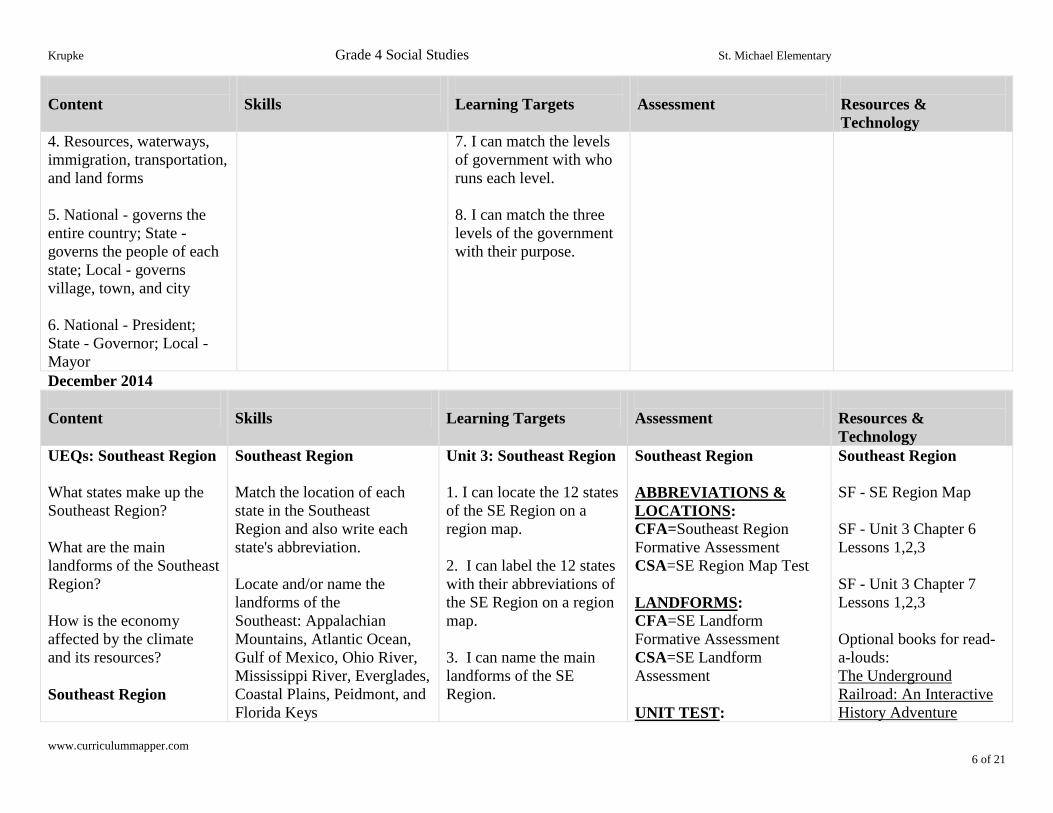
4. Resources, waterways,
immigration, transportation,
and land forms
5. National - governs the
entire country; State -
governs the people of each
state; Local - governs
village, town, and city
6. National - President;
State - Governor; Local -
Mayor
7. I can match the levels
of government with who
runs each level.
8. I can match the three
levels of the government
with their purpose.
December 2014
Content
Skills
Learning Targets
Assessment
Resources &
Technology
UEQs: Southeast Region
What states make up the
Southeast Region?
What are the main
landforms of the Southeast
Region?
How is the economy
affected by the climate
and its resources?
Southeast Region
Southeast Region
Match the location of each
state in the Southeast
Region and also write each
state's abbreviation.
Locate and/or name the
landforms of the
Southeast: Appalachian
Mountains, Atlantic Ocean,
Gulf of Mexico, Ohio River,
Mississippi River, Everglades,
Coastal Plains, Peidmont, and
Florida Keys
Unit 3: Southeast Region
1. I can locate the 12 states
of the SE Region on a
region map.
2. I can label the 12 states
with their abbreviations of
the SE Region on a region
map.
3. I can name the main
landforms of the SE
Region.
Southeast Region
ABBREVIATIONS &
LOCATIONS:
CFA=Southeast Region
Formative Assessment
CSA=SE Region Map Test
LANDFORMS:
CFA=SE Landform
Formative Assessment
CSA=SE Landform
Assessment
UNIT TEST:
Southeast Region
SF - SE Region Map
SF - Unit 3 Chapter 6
Lessons 1,2,3
SF - Unit 3 Chapter 7
Lessons 1,2,3
Optional books for read-
a-louds:
The Underground
Railroad: An Interactive
History Adventure
Krupke Grade 4 Social Studies St. Michael Elementary
www.curriculummapper.com 7 of 21
Content
Skills
Learning Targets
Assessment
Resources &
Technology
1. VA, WV, KY, NC, SC,
TN, AR, LA, MS, AL,
GA, FL
2. Appalachian
Mountains, Atlantic
Ocean, Gulf of Mexico,
Ohio River, Mississippi
River, Everglades, Coastal
Plains, Peidmont, and
Florida Keys
3. Longer growing
season because of warmer
temperatures and plentiful
rainfall
Resources: rich soil, trees,
coal
Economy: agriculture
industry, lumber industry,
coal mining
Compare and contrast where
agriculture resources are
found based on SF map page
181.
Vocabulary: hurricane,
endangered species, extinct,
plantation, Union,
Confederate, Civil War,
Reconstruction, civil rights,
segregate
4. I can tell how the
climate or resources of the
SE Region decides how
people earn a living.
5. I can find the meaning
of the key vocabulary
(hurricane, endangered,
species, extinct, plantation,
Union, Confederate, Civil
War, Reconstruction, civil
rights, and segregate) for
the SE Region.
CFA=Strive for Success on
SE Test
CSA=Southeast Region Test
American Girl Series:
Meet Addy
January 2015
Content
Skills
Learning Targets
Assessment
Resources &
Technology
UEQs: Southeast Region
What states make up the
Southeast Region?
Southeast Region
Match the location of each
state in the Southeast
Region and also write each
Unit 3: Southeast Region
1. I can locate the 12
states of the SE Region on
a region map.
Southeast Region
ABBREVIATIONS &
LOCATIONS:
CFA=Southeast Region
Southeast Region
SF - SE Region Map
SF - Unit 3 Chapter 6
Krupke Grade 4 Social Studies St. Michael Elementary
www.curriculummapper.com 8 of 21
Content
Skills
Learning Targets
Assessment
Resources &
Technology
What are the main
landforms of the Southeast
Region?
How is the economy
affected by the climate
and its resources?
Southeast Region
1. VA, WV, KY, NC, SC,
TN, AR, LA, MS, AL, GA,
FL
2. Appalachian Mountains,
Atlantic Ocean, Gulf of
Mexico, Ohio River,
Mississippi River,
Everglades, Coastal Plains,
Peidmont, and Florida Keys
3. Longer growing
season because of warmer
temperatures and plentiful
rainfall
Resources: rich soil, trees,
coal
Economy: agriculture
industry, lumber industry,
coal mining
state's abbreviation.
Locate and/or name the
landforms of the
Southeast: Appalachian
Mountains, Atlantic Ocean,
Gulf of Mexico, Ohio River,
Mississippi River, Everglades,
Coastal Plains, Peidmont, and
Florida Keys
Compare and contrast where
agriculture resources are
found based on SF map page
181.
Vocabulary: hurricane,
endangered species, extinct,
plantation, Union,
Confederate, Civil War,
Reconstruction, civil rights,
segregate
2. I can label the 12 states
with their abbreviations of
the SE Region on a region
map.
3. I can name the main
landforms of the SE
Region.
4. I can tell how the
climate or resources of the
SE Region decides how
people earn a living.
5. I can find the meaning
of the key vocabulary
(hurricane, endangered,
species, extinct,
plantation, Union,
Confederate, Civil War,
Reconstruction, civil
rights, and segregate) for
the SE Region.
Formative Assessment
CSA=SE Region Map Test
LANDFORMS:
CFA=SE Landform
Formative Assessment
CSA=SE Landform
Assessment
UNIT TEST:
CFA=Strive for Success on
SE Test
CSA=Southeast Region Test
Lessons 1,2,3
SF - Unit 3 Chapter 7
Lessons 1,2,3
Optional books for read
alouds:
The Underground
Railroad: An Interactive
History Adventure
American Girl Series:
Meet Addy
Krupke Grade 4 Social Studies St. Michael Elementary
www.curriculummapper.com 9 of 21
February 2015
Content
Skills
Learning Targets
Assessment
Resources &
Technology
UEQs: Midwest Region
What states make up the Midwest Region?
What are the main landforms of the Midwest
Region?
What affected the growth of major cities?
How is the economy affected by the climate
and its resources?
Midwest Region
1. ND,SD,NE,KS,MN,IA,MO,WI,IL,IN,MI,OH
2. Great Lakes (Lake Superior, Lake Michigan,
Lake Huron, Lake Erie, and Lake Ontario),
Mississippi River, Great Plains, Central Plains,
and Badlands
3. Duluth, MN; St. Louis, MO, WI; Chicago,
IL; fur trade
4. Rich soil improves agriculture and the
climate determines what crops are grown in
which area.
Midwest Region
Match the location
of each state in
the Midwest
Region and also
write each
state's abbreviation.
Locate and/or name the
landforms of the
Midwest: Great Lakes
(Lake Superior, Lake
Michigan, Lake Huron,
Lake Erie), Mississippi
River, Great Plains,
Central Plains, and
Badlands
Discuss the impact of
fur trade and
transportation on the
growth of major cities:
Duluth, MN; Chicago,
IL
Compare and contrast
the amount of rainfall in
the Central Plains vs the
Great Plains to
determine what crops
Unit 4: Midwest
Region
1. I can locate the
12 states of
the MW Region on
a region map.
2. I can label the 12
states with their
abbreviations of
the MW Region on
a region map.
3. I can name the
main landforms of
the MW Region.
4. I can give the
reason why Duluth,
MN; St. Louis,
MO; and Chicago,
IL became major
cities in the MW
Region.
5. I can tell how
the climate or
resources of the
MW Region
decides how people
Midwest Region
ABBREVIATIONS &
LOCATIONS:
CFA=Midwest Region
Formative Assessment
CSA=MW Region Map
Test
LANDFORMS:
CFA=MW Landform
Formative Assessment
CSA=MW Landform
Assessment
UNIT TEST:
CFA=Strive for Success
on MW Test
CSA=Midwest Region
Test
Midwest Region
SF - MW Region Map
SF - Unit 4 Chapter 8
Lessons 1,2,3
SF - Unit 4 Chapter 9
Lessons 1,2,3,4
Optional book for
read aloud:
The Dust Bowl: An
Interactive History
Adventure
Krupke Grade 4 Social Studies St. Michael Elementary
www.curriculummapper.com 10 of 21
Content
Skills
Learning Targets
Assessment
Resources &
Technology
are grown in which area
(pg 248, ws 57).
Vocabulary: canal,
barge, Badlands,
erosion, prairie,
irrigation, sod, drought
earn a living.
6. I can find the
meaning of the key
vocabulary (canal,
barge, Badlands,
erosion, prairie,
irrigation, sod, and
drought) for
the MW Region.
March 2015
Content
Skills
Learning Targets
Assessment
Resources &
Technology
UEQs: Midwest Region
What states make up the Midwest Region?
What are the main landforms of the Midwest
Region?
What affected the growth of major cities?
How is the economy affected by the climate
and its resources?
Midwest Region
1. ND,SD,NE,KS,MN,IA,MO,WI,IL,IN,MI,OH
2. Great Lakes (Lake Superior, Lake Michigan,
Lake Huron, Lake Erie, and Lake Ontario),
Midwest Region
Match the location
of each state in
the Midwest
Region and also
write each
state's abbreviation.
Locate and/or name the
landforms of the
Midwest: Great Lakes
(Lake Superior, Lake
Michigan, Lake Huron,
Lake Erie), Mississippi
River, Great Plains,
Central Plains, and
Badlands
Unit 4: Midwest
Region
1. I can locate the
12 states of the
MW Region on a
region map.
2. I can label the 12
states with their
abbreviations of the
MW Region on a
region map.
3. I can name the
main landforms of
the MW Region.
Midwest Region
ABBREVIATIONS &
LOCATIONS:
CFA=Midwest Region
Formative Assessment
CSA=MW Region Map
Test
LANDFORMS:
CFA=MW Landform
Formative Assessment
CSA=MW Landform
Assessment
UNIT TEST:
CFA=Strive for Success
on MW Test
Midwest Region
SF - MW Region Map
SF - Unit 4 Chapter 8
Lessons 1,2,3
SF - Unit 4 Chapter 9
Lessons 1,2,3,4
Optional book for
read-a-loud:
The Dust Bowl: An
Interactive History
Adventure

Krupke Grade 4 Social Studies St. Michael Elementary
www.curriculummapper.com 11 of 21
Content
Skills
Learning Targets
Assessment
Resources &
Technology
Mississippi River, Great Plains, Central Plains,
Badlands
3. Duluth, MN; St. Louis, MO; Chicago, IL;
fur trade
4. Rich soil improves agriculture and the
climate determines what crops are grown in
which area.
Discuss the impact of
fur trade and
transportation on the
growth of major cities:
Duluth, MN; Chicago,
IL
Compare and contrast
the amount of rainfall in
the Central Plains vs the
Great Plains to
determine what crops
are grown in which area
(pg 248, ws 57).
Vocabulary: canal,
barge, Badlands,
erosion, prairie,
irrigation, sod, drought
4. I can give the
reason why Duluth,
MN; St. Louis,
MO; and Chicago,
IL became major
cities in the MW
Region.
5. I can tell how the
climate or
resources of the
MW Region
decides how people
earn a living.
6. I can find the
meaning of the key
vocabulary (canal,
barge, Badlands,
erosion, prairie,
irrigation, sod, and
drought) for the
MW Region.
CSA=Midwest Region
Test
April 2015
Content
Skills
Learning Targets
Assessment
Resources & Technology
UEQs: Southwest Region
What states make up
the Southwest Region?
What are the main landforms
Southwest Region
Match the location of each
state in the Southwest
Region and also write each
state's abbreviation.
Unit 5: Southwest
Region
1. I can locate the 4 states
of the SW Region on a
region map.
Southwest Region
ABBREVIATIONS &
LOCATIONS: CFA=Southwest Region
Formative Assessment
CSA=SW Region Map
Southwest Region
SF - SW Region Map
SF - Unit 5 Chapter 10
Lessons 1,2,3
Krupke Grade 4 Social Studies St. Michael Elementary
www.curriculummapper.com 12 of 21
Content
Skills
Learning Targets
Assessment
Resources & Technology
of the Southwest Region?
How is the economy affected
by its resources?
Southwest Region
1. AZ, NM,TX, and OK
2. Grand Canyon, Rocky
Mountains, Gulf of Mexico,
Rio Grande, and Sonoran
Desert
3. Oil, Technology
(electronic, aviation, space
industries), and Ranching
(cattle drives and beef
market)
UEQs: West Region
What states make up
the West Region?
What are the main landforms
of the West Region?
What affected the growth of
major cities?
How is the economy affected
Locate and/or name the
landforms of the
Southwest: Grand Canyon,
Rocky Mountains, Gulf of
Mexico, Rio Grande, and
Sonoran Desert
Identify the job
opportunities related to its
resources of oil, technology,
and ranching.
Vocabulary: arid,
missionary, adobe, pueblo,
refinery, savanna
West Region
Match the location of each
state in the Southwest
Region and also write each
state's abbreviation.
Locate and/or name the
landforms of the
Southwest: Pacific Ocean,
2. I can label the 4 states
with their abbreviations
of the SW Region on a
region map.
3. I can name the main
landforms of the SW
Region.
4. I can tell how the
climate or resources of
the SW Region decides
how people earn a living.
5. I can find the meaning
of the key vocabulary
(arid, missionary, adobe,
pueblo, refinery, and
savanna) for the SW
Region.
Unit 6: West Region
1. I can locate the 11
states of the W Region on
a region map.
2. I can label the 11 states
Test
LANDFORMS:
CFA=SW Landform
Formative Assessment
CSA=SW Landform
Assessment
UNIT TEST: CFA=Strive for Success on
SW Test
CSA=Southwest Region
Test
West Region
ABBREVIATIONS &
LOCATIONS:
CFA=West Region
Formative Assessment
CSA=W Region Map Test
LANDFORMS:
CFA=W Landform
Formative Assessment
CSA=W Landform
SF - Unit 5 Chapter 11
Lessons 1,2,3
West Region
SF - W Region Map
SF - Unit 6 Chapter 12
Lessons 1,2,3
SF - Unit 6 Chapter 13
Lessons 1,2,3
Optional book to read-a-
loud:
The California Gold Rush:
Krupke Grade 4 Social Studies St. Michael Elementary
www.curriculummapper.com 13 of 21
Content
Skills
Learning Targets
Assessment
Resources & Technology
by the climate and its
resources?
West Region
1. WA, CA, NV, OR, ID,
UT, MT, WY, CO
2. Pacific Ocean, Rocky
Mountains, Yellowstone
National Park, Mount
McKinley (Denali), Death
Valley, Great Basin, and
Great Salt Lake
3. Los Angelos, CA (climate
for filming movies); Seatle,
WA (technology); Salt Lake
City, UT (mining and
tourism); San Francisco, CA
(missions and port)
4. Tourism, mining,
computer software,
entertainment (movies),
international trade,
agriculture
Rocky Mountains,
Yellowstone National Park,
Mount McKinley (Denali),
Death Valley, Great Basin,
and Great Salt Lake
Compare and contrast
tundra and desert (Use Venn
Diagram).
Discuss the advantages and
disadvantages of the Gold
Rush (Boom Towns and
Ghost Towns).
Identify the major city
and/or state with
the resource it provides.
vocabulary: geyser,
volcano, tundra, livestock,
prospector
with their abbreviations
of the W Region on a
region map.
3. I can name the main
landforms of the W
Region.
4. I can give the reason
why Los Angeles, CA;
Seattle, WA; Salt Lake
City, UT; and San
Francisco, CA became
major cities in the W
Region.
5. I can tell how the
climate or resources of
the W Region decides
how people earn a living.
6. I can find the meaning
of the key vocabulary
(geyser, volcano, tundra,
livestock, and prospector)
for the W Region.
Assessment
UNIT TEST:
CFA=Strive for Success on
W Test
CSA=West Region Test
An Interactive History
Adventure
May 2015
Content
Skills
Learning Targets
Assessment
Resources & Technology
UEQs: West Region West Region Unit 6: West Region West Region West Region
Krupke Grade 4 Social Studies St. Michael Elementary
www.curriculummapper.com 14 of 21
Content
Skills
Learning Targets
Assessment
Resources & Technology
What states make up
the West Region?
What are the main
landforms of the West
Region?
What affected the growth of
major cities?
How is the economy
affected by the climate
and its resources?
West Region
1. WA, CA, NV, OR, ID,
UT, MT, WY, CO, HI, AK
2. Pacific Ocean, Rocky
Mountains, Yellowstone
National Park, Mount
McKinley (Denali), Death
Valley, Great Basin, and
Great Salt Lake
3. Los Angelos, CA (climate
for filming movies); Seatle,
WA (technology); Salt Lake
City, UT (mining and
tourism); San Francisco, CA
(missions and port)
Match the location of each
state in the Southwest
Region and also write each
state's abbreviation.
Locate and/or name the
landforms of the
Southwest: Pacific Ocean,
Rocky Mountains,
Yellowstone National Park,
Mount McKinley (Denali),
Death Valley, Great Basin,
and Great Salt Lake
Compare and contrast
tundra and desert (Use
Venn Diagram).
Discuss the advantages and
disadvantages of the Gold
Rush (Boom Towns and
Ghost Towns).
Identify the major city
and/or state with
the resource it provides.
vocabulary: geyser,
volcano, tundra, livestock,
prospector
1. I can locate the 11 states
of the W Region on a region
map.
2. I can label the 11 states
with their abbreviations of
the W Region on a region
map.
3. I can name the main
landforms of the W Region.
4. I can give the reason
why Los Angeles, CA;
Seattle, WA; Salt Lake City,
UT; and San Francisco,
CA became major cities in
the W Region.
5. I can tell how the climate
or resources of the W
Region decides how people
earn a living.
6. I can find the meaning of
the key vocabulary (geyser,
volcano, tundra, livestock,
and prospector) for the W
Region.
ABBREVIATIONS &
LOCATIONS:
CFA=West Region
Formative Assessment
CSA=W Region Map Test
LANDFORMS:
CFA=W Landform
Formative Assessment
CSA=W Landform
Assessment
UNIT TEST:
CFA=Strive for Success
on W Test
CSA=West Region Test
SF - W Region Map
SF - Unit 6 Chapter 12
Lessons 1,2,3
SF - Unit 6 Chapter 13
Lessons 1,2,3
Optional Final State Test
(Not graded)
Krupke Grade 4 Social Studies St. Michael Elementary
www.curriculummapper.com 15 of 21
Content
Skills
Learning Targets
Assessment
Resources & Technology
4. Tourism, mining,
computer software,
entertainment (movies),
international trade,
agriculture
UEQs: Economics
What is scarcity?
How are decisions and
choices affected by
opportunity cost and
scarcity?
What is income?
Why may it be important to
save money?
What are the differences
between
producers/consumers and
goods/services?
How does a market
economy answer what gets
produced, how it is
produced, and who receives
it?
Economics
Economics
Discuss or apply a reasoned
decision-making process or
chart to make a choice of
buying a new game.
Debate the pros and cons of
saving money.
Identify when or how a
student may become a
producer and also when
they act as a consumer.
vocabulary: product,
service, need, want,
producer, consumer,
economy, profit, demand,
supply, opportunity cost
Unit 7: Economics
1. I can tell what scarcity
means.
2. I can tell the difference
between
producer/consumer&
goods/services.
3. I can explain why it is
important to save money.
4. I can tell the meaning of
the key vocabulary (product,
service, need, want,
producer, consumer,
economy, profit, demand,
supply, and opportunity
cost) for Economics.
Economics
UNIT TEST:
CFA=Strive for Success
on the Economics Test
CSA=Economics Test
CA=Public Speaking
and/or Technology
Integration (Not graded,
feed back only)
examples: present a
business or product in
an infomercial style, etc.
Economics
SF - Unit 1 Chapter 3
Lesson 2 (pgs 72-79)
DVD (23 minutes video):
"Economics for Children:
What is Economics?"
(borrow DVD from Renee
Krupke at STME)
Economic Slides for
interactive review
Economic Teacher's Guide
(includes read-a-loud
stories for comprehension
questions, etc.)
Economic Student Packet
with comprehension
questions
from edHelper.com
economic-related stories of
"The Little Red Hen Learns
About Economics,"
"Scarcity," and "Three
Different Choices" along
with "The Grasshopper and
the Ant: A Fable About
Saving"
Krupke Grade 4 Social Studies St. Michael Elementary
www.curriculummapper.com 16 of 21
Content
Skills
Learning Targets
Assessment
Resources & Technology
1. Scarcity is when there is
very little left of a good or
product.
2. People cannot have
everything they want. So
they must weigh their
decisions on what to buy.
They need to base their
decisions on what they may
be giving up by buying what
they choose (opportunity
cost) and what is or isn't
available (scarcity).
3. Income is the amount of
money a person earns or that
a business takes in from the
sales of goods, products, or
services.
4. People save money for
many reasons: to buy
something special, to have
money on hand for
unexpected expenses and/or
unexpected opportunities,
and then for the low risk-
takers to have more money
to invest, etc.
5. Producers make goods or
Scott Foresman Level
Readers (complete Cause
and Effect WS with
appropriate student level)
Below Level: Our
Economy
On Level: The Economy
and How It Works
Above Level: The
American Economy
Krupke Grade 4 Social Studies St. Michael Elementary
www.curriculummapper.com 17 of 21
Content
Skills
Learning Targets
Assessment
Resources & Technology
products while consumers
buy goods, products, or
services. Goods are items
made to be sold and services
are things workers provide
for people who don't have
that skill.
6. Our free enterprise
system allows all businesses
to produce and sell whatever
they want.
June 2015
Content
Skills
Learning Targets
Assessment
Resources & Technology
UEQs: West Region
What states make up
the West Region?
What are the main landforms
of the West Region?
What affected the growth of
major cities?
How is the economy affected
by the climate and its
resources?
West Region
West Region
Match the location of each
state in the Southwest
Region and also write each
state's abbreviation.
Locate and/or name the
landforms of the
Southwest: Pacific Ocean,
Rocky Mountains,
Continential Divide,
Yellowstone National Park,
Mount McKinley (Denali),
Death Valley, Great Basin,
and Great Salt Lake
Unit 6: West Region
1. I can locate the 11 states
of the W Region on a region
map.
2. I can label the 11 states
with their abbreviations of
the W Region on a region
map.
3. I can name the main
landforms of the W Region.
4. I can give the reason why
Los Angeles, CA; Seattle,
WA; Salt Lake City, UT;
West Region
ABBREVIATIONS &
LOCATIONS:
CFA=West Region
Formative Assessment
CSA=W Region Map Test
LANDFORMS:
CFA=W Landform
Formative Assessment
CSA=W Landform
Assessment
UNIT TEST:
CFA=Strive for Success
on W Test
CSA=West Region Test
West Region Economics
SF - W Region Map
SF - Unit 6 Chapter 12
Lessons 1,2,3
SF - Unit 6 Chapter 13
Lessons 1,2,3
Optional Final State Test
(Not graded)
Krupke Grade 4 Social Studies St. Michael Elementary
www.curriculummapper.com 18 of 21
Content
Skills
Learning Targets
Assessment
Resources & Technology
1. WA, CA, NV, OR, ID,
UT, MT, WY, CO
HI, AK
2. Pacific Ocean, Rocky
Mountains, Continential
Divide, Yellowstone
National Park, Mount
McKinley (Denali), Death
Valley, Great Basin, and
Great Salt Lake
3. Los Angelos, CA (climate
for filming movies); Seatle,
WA (technology); Salt Lake
City, UT (mining and
tourism); San Francisco, CA
(missions and port)
4. Tourism, mining,
computer software,
entertainment (movies),
international trade,
agriculture
UEQs: Economics
What is scarcity?
How are decisions and
choices affected by
opportunity cost and
Compare and contrast
tundra and desert (Use Venn
Diagram).
Discuss the advantages and
disadvantages of the Gold
Rush (Boom Towns and
Ghost Towns).
Identify the major city
and/or state with
the resource it provides.
vocabulary: geyser,
volcano, tundra, livestock,
prospector
Economics
Discuss or apply a reasoned
decision-making process or
chart to make a choice of
buying a new game.
and San Francisco, CA
became major cities in the
W Region.
5. I can tell how the climate
or resources of the W
Region decides how people
earn a living.
6. I can find the meaning of
the key vocabulary (geyser,
volcano, tundra, livestock,
and prospector) for the W
Region.
Unit 7: Economics
1. I can tell what scarcity
means.
2. I can tell the difference
between producer/consumer
& goods/services.
Economics
UNIT TEST:
CFA=Strive for Success
on the Economics Test
CSA=Economics Test
CA=Public Speaking
and/or Technology
Integration (Not graded,
feed back only)
examples: present a
Economics
SF - Unit 1 Chapter 3
Lesson 2 (pgs 72-79)
DVD (23 minutes video):
"Economics for Children:
What is Economics?"
(borrow DVD from Renee
Krupke at STME)
Economic Slides for
interactive review
Krupke Grade 4 Social Studies St. Michael Elementary
www.curriculummapper.com 19 of 21
Content
Skills
Learning Targets
Assessment
Resources & Technology
scarcity?
What is income?
Why may it be important to
save money?
What are the differences
between
producers/consumers and
goods/services?
How does a market economy
answer what gets produced,
how it is produced, and who
receives it?
Economics
1. Scarcity is when there is
very little left of a good or
product.
2. People cannot have
everything they want. So
they must weigh their
decisions on what to buy.
They need to base their
decisions on what they may
be giving up by buying what
they choose (opportunity
cost) and what is or isn't
available (scarcity).
Debate the pros and cons of
saving money.
Identify when or how a
student may become a
producer and also when
they act as a consumer.
vocabulary: product,
service, need, want,
producer, consumer,
economy, profit, demand,
supply, opportunity cost
3. I can explain why it is
important to save money.
4. I can tell the meaning of
the key vocabulary
(product, service, need,
want, producer, consumer,
economy, profit, demand,
supply, and opportunity
cost) for Economics.
business or product in an
infomercial style, etc.
Economic Teacher's
Guide (includes read-a-
loud stories for
comprehension questions,
etc.)
Economic Student Packet
with comprehension
questions from
edHelper.com economic-
related stories of "The
Little Red Hen Learns
About Economics,"
"Scarcity," and "Three
Different Choices" along
with "The Grasshopper
and the Ant: A Fable
About Saving"
Scott Foresman Level
Readers (complete Cause
and Effect WS with
appropriate student level)
Below Level: Our
Economy
On Level: The Economy
and How It Works
Above Level: The
American Economy
Krupke Grade 4 Social Studies St. Michael Elementary
www.curriculummapper.com 20 of 21
Content
Skills
Learning Targets
Assessment
Resources & Technology
3. Income is the amount of
money a person earns or that
a business takes in from the
sales of goods, products, or
services.
4. People save money for
many reasons: to buy
something special, to have
money on hand for
unexpected expenses and/or
unexpected opportunities,
and then for the low risk-
takers to have more money
to invest, etc.
5. Producers make goods or
products while consumers
buy goods, products, or
services. Goods are items
made to be sold and services
are things workers provide
for people who don't have
that skill.
6. Our free enterprise system
allows all businesses to
produce and sell whatever
they want.
Economics
SF - Unit 1 Chapter 3
Lesson 2 (pgs 72-79)
DVD (23 minutes video):
"Economics for Children:
What is Economics?"
(borrow DVD from Renee
Krupke Grade 4 Social Studies St. Michael Elementary
www.curriculummapper.com 21 of 21
Content
Skills
Learning Targets
Assessment
Resources & Technology
Krupke at STME)
Financial Fitness for
Life: Exercise 4.1 story
"The Grasshopper and the
Ant: A Fable About
Saving"
edHelper.com economic-
related stories of
"Scarcity" and "Three
Different Choices"