Embed Size (px)
DESCRIPTION
GPS Status & Modernization Briefing to National PNT Advisory Board 29 March 2007. Col Allan Ballenger Commander, GPS Wing. Overview. GPS System Description GPS Constellation Status & Availability Recent GPS Accomplishments GPS Modernization Summary. - PowerPoint PPT Presentation
Citation preview

I n t e g r i t y - S e r v i c e - E x c e l l e n c e
Headquarters U.S. Air Force
GPSW Brief to PNT Advisory Board 29 Mar 07 v5
GPS Status & Modernization
Briefing to National PNT Advisory Board
29 March 2007
Col Allan BallengerCommander, GPS Wing
Slide 2I n t e g r i t y - S e r v i c e - E x c e l l e n c eGPSW Brief to PNT Advisory Board 29 Mar 07 v5
GPS System Description GPS Constellation Status & Availability Recent GPS Accomplishments GPS Modernization Summary
Overview
Department of Defense and Air Force are committedto responsible stewardship of GPS as a global utility

Slide 3I n t e g r i t y - S e r v i c e - E x c e l l e n c eGPSW Brief to PNT Advisory Board 29 Mar 07 v5
GPS System DescriptionMission

Slide 4I n t e g r i t y - S e r v i c e - E x c e l l e n c eGPSW Brief to PNT Advisory Board 29 Mar 07 v5
Department of Transportation•Federal Aviation Administration (FAA)
Department of Defense• Services (Army, Navy, AF, Marines)• Agencies (NGA, DISA, etc.)
Civil Applications• Search and rescue• Surveying and mapping• Trucking, shipping and Aviation• Banking and Finance• Offshore drilling• Fishing and boating
International Cooperation• Japan – QZSS• Russia - GLONASS• Europe and other countries
GPS System DescriptionGPS Enterprise
Department of Homeland Security•Coast Guard

Slide 5I n t e g r i t y - S e r v i c e - E x c e l l e n c eGPSW Brief to PNT Advisory Board 29 Mar 07 v5
GPS System DescriptionWhat Are the GPS Segments?

Slide 6I n t e g r i t y - S e r v i c e - E x c e l l e n c eGPSW Brief to PNT Advisory Board 29 Mar 07 v5
16 Block IIA satellites operational 12 Block IIR satellites operational 3 Block IIR-M satellites operational
5 additional IIR-M satellites to launch Since Dec 93, U.S. Government met/exceeded
civil GPS service performance commitments SPS Performance Standard (PS)
U.S. DoD committed to superior GPS service
30 Healthy SatellitesBaseline Constellation: 24
GPS Constellation Status & Availabilityas of March 2007
as of 26 Mar 07
Slide 7I n t e g r i t y - S e r v i c e - E x c e l l e n c eGPSW Brief to PNT Advisory Board 29 Mar 07 v5
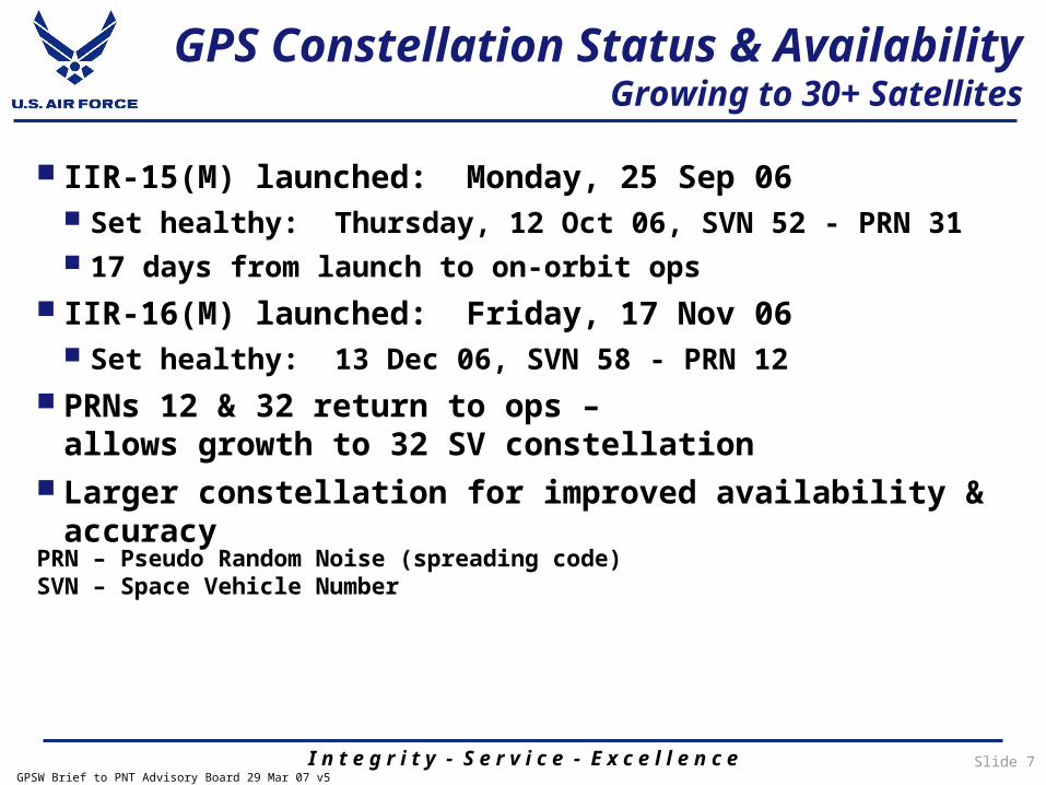
GPS Constellation Status & AvailabilityGrowing to 30+ Satellites
IIR-15(M) launched: Monday, 25 Sep 06 Set healthy: Thursday, 12 Oct 06, SVN 52 - PRN 31 17 days from launch to on-orbit ops
IIR-16(M) launched: Friday, 17 Nov 06 Set healthy: 13 Dec 06, SVN 58 - PRN 12
PRNs 12 & 32 return to ops –allows growth to 32 SV constellation
Larger constellation for improved availability & accuracy
PRN – Pseudo Random Noise (spreading code)SVN – Space Vehicle Number

Slide 8I n t e g r i t y - S e r v i c e - E x c e l l e n c eGPSW Brief to PNT Advisory Board 29 Mar 07 v5
Launched a new era of GPS services First GPS IIR-M (14) launched 25 Sep 05, operational 16 Dec 05 New military signal (M-Code) and new civil signal (L2C) GPS IIR-M (15) launched 25 Sep 06; IIR-16(M) launched 17 Nov 06
Fielded operational improvements Legacy Accuracy Improvement Initiative –
improves position accuracy over 10% Provide “zero age of data” to warfighters Delivered 100,000+ DAGRs, 250,000+ SAASMs
OSD/NII signed Precise Positioning Service Performance Standard,23 Feb 07 – enables certification of military GPS use in US airspace
New acquisition strategies for next generation GPS “Back to Basics” and incremental block approach
GPS Block III satellites GPS Block III Next-Generation Control Segment (OCX) Modernized User Equipment/Modernized Space Receiver
Recent GPS Accomplishments

Slide 9I n t e g r i t y - S e r v i c e - E x c e l l e n c eGPSW Brief to PNT Advisory Board 29 Mar 07 v5
GPS IIR-136 Nov 04
GPS IIR-15(M)25 Sep 06
GPS IIR-14(M)25 Sep 05
1st Modernized GPS Satellite
GPS IIR-16(M)17 Nov 06
A world class team providing worldwide position, navigation & timing!
Recent GPS Accomplishments Our Mission Successes
Slide 10I n t e g r i t y - S e r v i c e - E x c e l l e n c eGPSW Brief to PNT Advisory Board 29 Mar 07 v5
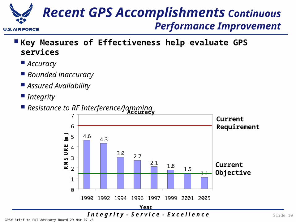
Key Measures of Effectiveness help evaluate GPS services Accuracy Bounded inaccuracy Assured Availability Integrity Resistance to RF Interference/Jamming
4.6 4.3
3.0 2.72.1 1.8 1.5
1.1
0
1
2
3
4
5
6
7
1990 1992 1994 1996 1997 1999 2001 2005
Year
RM
S U
RE
(m)
AccuracyCurrent Requirement
Current Objective
Recent GPS Accomplishments Continuous Performance Improvement
Slide 11I n t e g r i t y - S e r v i c e - E x c e l l e n c eGPSW Brief to PNT Advisory Board 29 Mar 07 v5
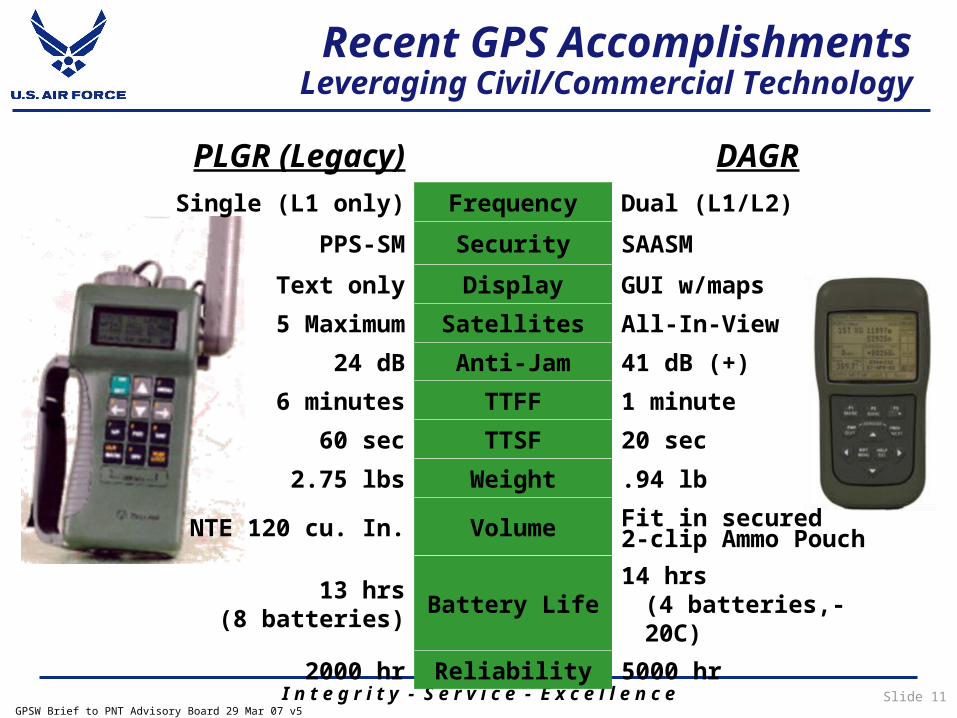
PLGR (Legacy) DAGRSingle (L1 only) Frequency Dual (L1/L2)
PPS-SM Security SAASMText only Display GUI w/maps
5 Maximum Satellites All-In-View24 dB Anti-Jam 41 dB (+)
6 minutes TTFF 1 minute60 sec TTSF 20 sec
2.75 lbs Weight .94 lb
NTE 120 cu. In. Volume Fit in secured 2-clip Ammo Pouch
13 hrs(8 batteries) Battery Life 14 hrs
(4 batteries,-20C)2000 hr Reliability 5000 hr
Recent GPS AccomplishmentsLeveraging Civil/Commercial Technology
Slide 12I n t e g r i t y - S e r v i c e - E x c e l l e n c eGPSW Brief to PNT Advisory Board 29 Mar 07 v5
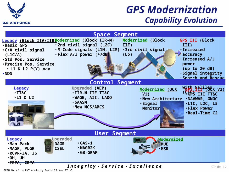
GPS III (Block III)• Increased accuracy • Increased A/J power
(up to 20 dB)• Signal integrity• Search and Rescue• Common signals
with Galileo (L1C)
Legacy (Block IIA/IIR)• Basic GPS• C/A civil signal (L1C/A)• Std Pos. Service• Precise Pos. Service
• L1 & L2 P(Y) nav• NDS
Modernized (Block IIR-M)• 2nd civil signal (L2C)• M-Code signals (L1M, L2M)• Flex A/J power (+7dB)
Space SegmentModernized (Block IIF) •3rd civil signal (L5)
Upgraded (AEP)• IIR-M IIF TT&C• WAGE, AII, LADO• SAASM• New MCS/AMCS
Modernized (OCX V1)• New Architecture• Signal Monitoring
Legacy• TT&C• L1 & L2 monitoring
Control Segment
User SegmentLegacy• Man Pack• MAGR, PLGR• RCVR-3A, 3S • OH, UH• FRPA, CRPA
Upgraded• DAGR• CSEL
• GAS-1• MAGR2K• GB-GRAM
Modernized• MUE• MSR
GPS III (OCX V2)• GPS III TT&C• NAVWAR, GNOC• L1C, L2C, L5• Flex Power• Real-Time C2
GPS ModernizationCapability Evolution
Slide 13I n t e g r i t y - S e r v i c e - E x c e l l e n c eGPSW Brief to PNT Advisory Board 29 Mar 07 v5
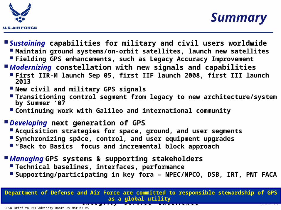
Sustaining capabilities for military and civil users worldwide Maintain ground systems/on-orbit satellites, launch new satellites Fielding GPS enhancements, such as Legacy Accuracy Improvement
Modernizing constellation with new signals and capabilities First IIR-M launch Sep 05, first IIF launch 2008, first III launch 2013 New civil and military GPS signals Transitioning control segment from legacy to new architecture/system
by Summer ‘07 Continuing work with Galileo and international community
Developing next generation of GPS Acquisition strategies for space, ground, and user segments Synchronizing space, control, and user equipment upgrades “Back to Basics” focus and incremental block approach
Managing GPS systems & supporting stakeholders Technical baselines, interfaces, performance Supporting/participating in key fora – NPEC/NPCO, DSB, IRT, PNT FACADepartment of Defense and Air Force are committed to responsible stewardship of GPS as a global
utility
Summary