Embed Size (px)
Citation preview
2014 06 01 _GPS Program Update for PNT Advisory Board Final.pptx
Space and Missile Systems Center
Lt Col Brian K. Bailey
Global Positioning Systems Directorate
June 2014
GPS Modernization
Update

2014 06 01 _GPS Program Update for PNT Advisory Board Final.pptx
S P A C E A N D M I S S I L E S Y S T E M S C E N T E R
GPS Constellation
• Robust constellation
– 30 space vehicles currently set healthy
• 6 GPS IIA, 12 GPS IIR, 7 GPS IIR-M, 5 GPS IIF
– 5 additional satellites in residual status, 1 in test status
– SV-6 successfully launched 16 May 14
• 6 more GPS IIFs in pipeline
– SV-7 scheduled for Jul 2014 launch
– SVs 8 and 10-12 in storage; SV-9 pending final testing
• Extensive International and Civil Cooperation
– Agreements with 57 international customers
– ~2 billion civil/commercial users
• Global GPS civil service performance
commitment met continuously since Dec 1993
– Best performance 46.6 cm User Range Error (URE) 8 Jun 13;
best weekly average 64.6 cm URE 16 Apr 14
– Performance improving as new satellites replace older satellites
2014 06 01 _GPS Program Update for PNT Advisory Board Final.pptx
S P A C E A N D M I S S I L E S Y S T E M S C E N T E R
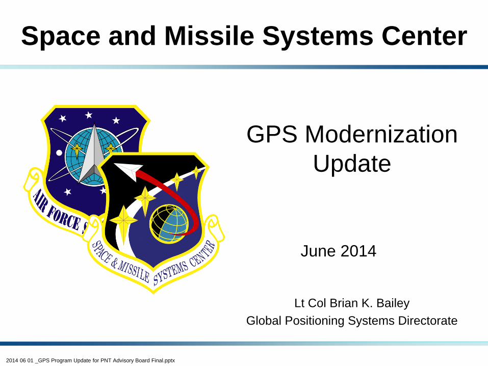
GPS Signal in Space Performance
System accuracy exceeds published standard
Precise Positioning Service (PPS) Signal-in-Space Performance
Standard Positioning Service (SPS) Signal-in-Space Performance
Standard Positioning Service (SPS) Signal-in-Space Performance
Precise Positioning Service (PPS) Signal-in-Space Performance
2014 06 01 _GPS Program Update for PNT Advisory Board Final.pptx
S P A C E A N D M I S S I L E S Y S T E M S C E N T E R
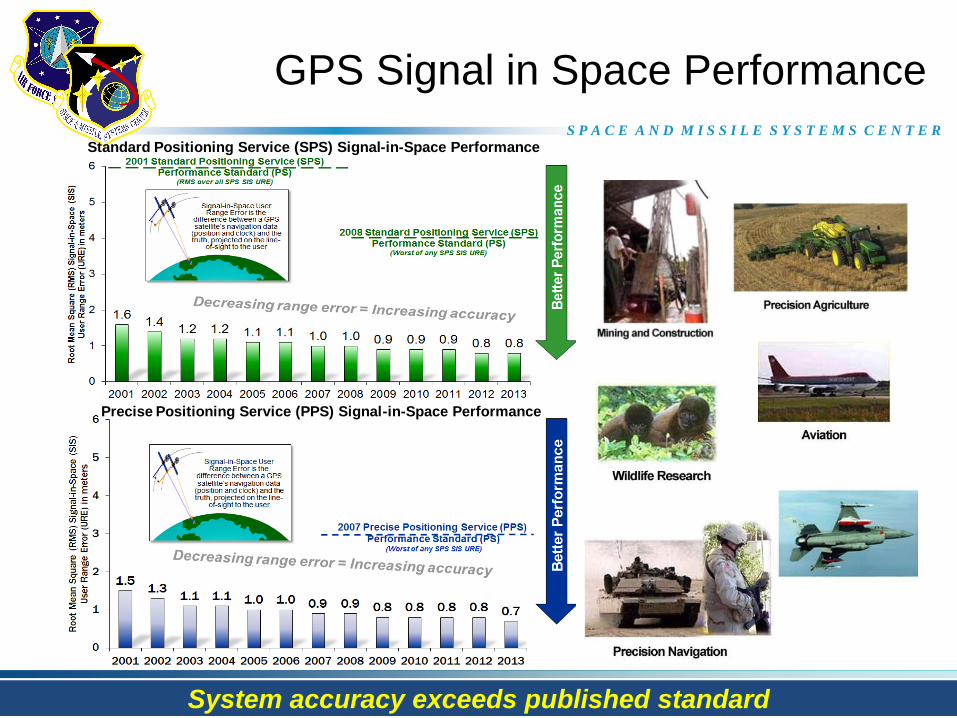
Legacy GPS IIA/IIR
• Single Frequency (L1)
• Coarse acquisition (C/A) code
• Y-Code (L1Y & L2Y)
GPS IIR-M
• 2nd Civil Signal (L2C)
• M-Code (L1M & L2M)
GPS IIF
• 3rd civil signal (L5)
• 2 Rb + 1 Cs Clocks
• 12 year design life
GPS III
• 4th civil signal (L1C)
• 4x better User Range Error than GPS IIF
• Increased availability
• Increased integrity
• 15 year design life
Legacy
Operational
Control Segment
(OCS)
• Mainframe system • Command & Control • Signal monitoring
Architecture Evolution
Plan (AEP)
• Distributed architecture • Increased signal monitoring • Security & Accuracy • Launch and disposal ops
OCX Block 1
• Transition from OCS to
OCX for all GPS
command and control
operations
GPS Modernization Program
Increasing system capabilities - Increasing user benefit
Next Generation Operational
Control System (OCX) Block 0
• Launch & On-Orbit
Checkout of GPS III
• Fly legacy constellation
2014 06 01 _GPS Program Update for PNT Advisory Board Final.pptx
S P A C E A N D M I S S I L E S Y S T E M S C E N T E R
• Initiated continuous CNAV message broadcast (L2C & L5) on 28 Apr 14
• CNAV Data message uploaded twice a week initially; with daily uploads
expected by Dec 2014
• Position accuracy not guaranteed during pre-operational deployment of
CNAV signals; “use at own risk”
– L2C message currently set “healthy”
– L5 message set “unhealthy” until sufficient monitoring capability established
(signal verification)
• Expected Performance for users:
– During first 24 hours after upload, CNAV performs as LNAV
– Expect divergence between CNAV & LNAV as CNAV data ages until next
CNAV upload
CNAV Pre-Operational Deployment
2014 06 01 _GPS Program Update for PNT Advisory Board Final.pptx
S P A C E A N D M I S S I L E S Y S T E M S C E N T E R
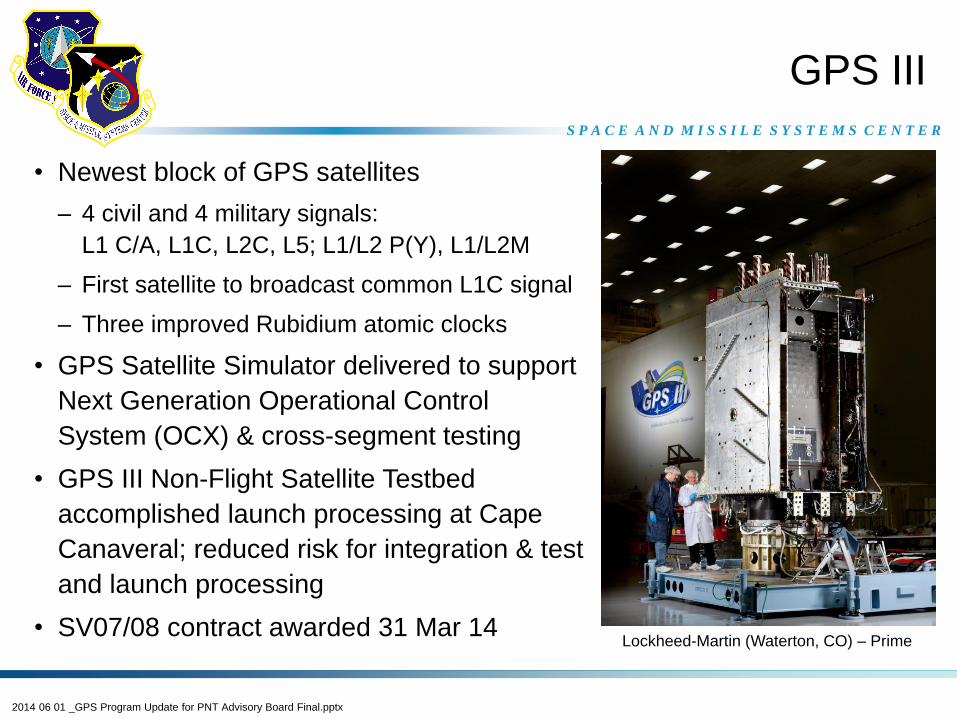
• Newest block of GPS satellites
– 4 civil and 4 military signals:
L1 C/A, L1C, L2C, L5; L1/L2 P(Y), L1/L2M
– First satellite to broadcast common L1C signal
– Three improved Rubidium atomic clocks
• GPS Satellite Simulator delivered to support
Next Generation Operational Control
System (OCX) & cross-segment testing
• GPS III Non-Flight Satellite Testbed
accomplished launch processing at Cape
Canaveral; reduced risk for integration & test
and launch processing
• SV07/08 contract awarded 31 Mar 14
GPS III
Lockheed-Martin (Waterton, CO) – Prime
2014 06 01 _GPS Program Update for PNT Advisory Board Final.pptx
S P A C E A N D M I S S I L E S Y S T E M S C E N T E R
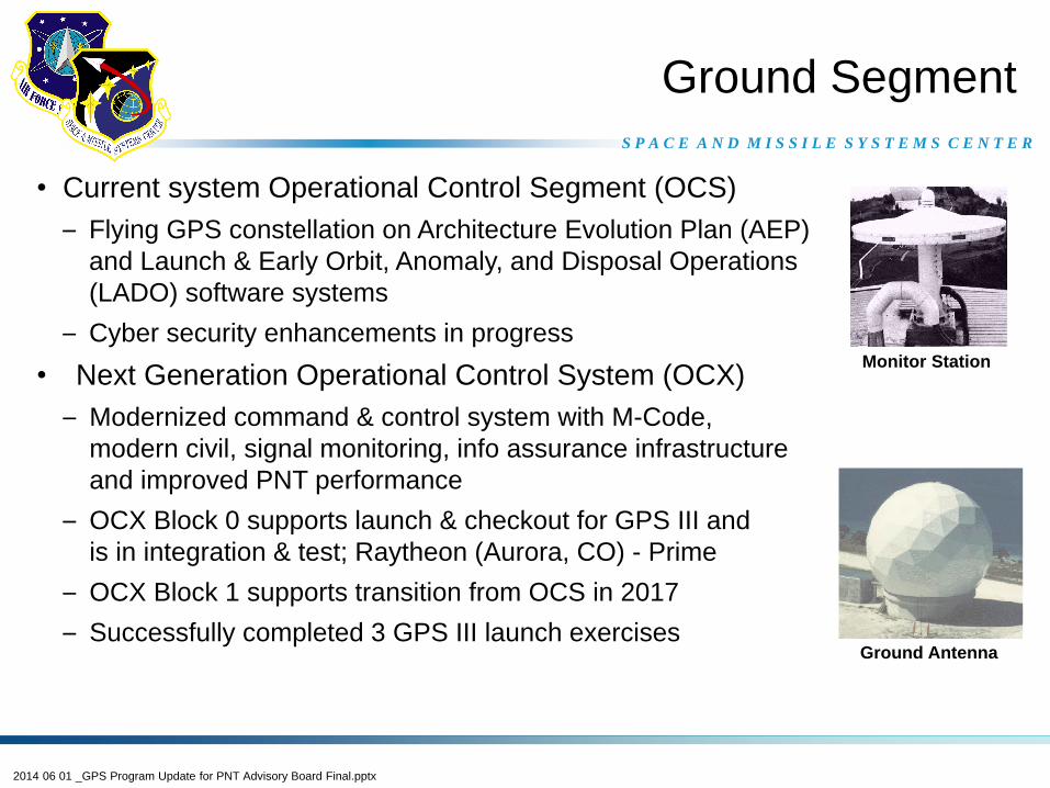
Ground Segment
• Current system Operational Control Segment (OCS)
– Flying GPS constellation on Architecture Evolution Plan (AEP)
and Launch & Early Orbit, Anomaly, and Disposal Operations
(LADO) software systems
– Cyber security enhancements in progress
• Next Generation Operational Control System (OCX)
– Modernized command & control system with M-Code,
modern civil, signal monitoring, info assurance infrastructure
and improved PNT performance
– OCX Block 0 supports launch & checkout for GPS III and
is in integration & test; Raytheon (Aurora, CO) - Prime
– OCX Block 1 supports transition from OCS in 2017
– Successfully completed 3 GPS III launch exercises
Monitor Station
Ground Antenna
2014 06 01 _GPS Program Update for PNT Advisory Board Final.pptx
S P A C E A N D M I S S I L E S Y S T E M S C E N T E R
Spectrum Allocation
and
Sharing Initiatives
2014 06 01 _GPS Program Update for PNT Advisory Board Final.pptx
S P A C E A N D M I S S I L E S Y S T E M S C E N T E R
• International & Domestic push to reallocate or share spectrum on
L-Band for mobile services
• Domestically, Presidential Memo regarding providing 500 MHz of
spectrum for mobile services
– Adjacent-Band Capability (ABC) study initiated to ensure GPS receiver
performance
• Internationally, working through the World Radiocommunication
Conference to identify spectrum allocation opportunities and to ensure
Global Navigation Satellite System (GNSS) performance
Spectrum Allocation and
Sharing Initiatives
Fully support the allocation and sharing of spectrum through
robust analysis, testing and specification development
2014 06 01 _GPS Program Update for PNT Advisory Board Final.pptx
S P A C E A N D M I S S I L E S Y S T E M S C E N T E R
• Setup / provide representative receiver hardware to model interference
scenarios
• Provide subject matter experts as required to conduct analysis & testing
• Use existing GPS public forums to involve receiver community
AFSPC Contribution to
Adjacent-Band Compatibility (ABC) Study
Partnership with DOT to ensure successful spectrum allocation & sharing
2014 06 01 _GPS Program Update for PNT Advisory Board Final.pptx
S P A C E A N D M I S S I L E S Y S T E M S C E N T E R
• Working through the 2012 World Radiocommunication Conference
(WRC-12)
– Consider additional spectrum allocations for the mobile service on a
primary basis
– Identify additional frequency bands for International Mobile
Telecommunications (IMT) operations
• GPS Directorate Goal: monitor all GPS bands and adjacent bands being
proposed as candidate bands for reallocation or sharing with IMT
• Various US agencies and international GNSS providers share this
interest to help protect GPS
International Spectrum Reallocations
for Mobile Sources
2014 06 01 _GPS Program Update for PNT Advisory Board Final.pptx
S P A C E A N D M I S S I L E S Y S T E M S C E N T E R
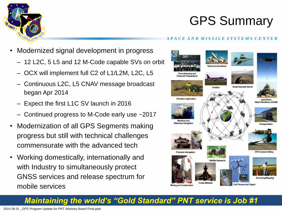
• Modernized signal development in progress
– 12 L2C, 5 L5 and 12 M-Code capable SVs on orbit
– OCX will implement full C2 of L1/L2M, L2C, L5
– Continuous L2C, L5 CNAV message broadcast
began Apr 2014
– Expect the first L1C SV launch in 2016
– Continued progress to M-Code early use ~2017
• Modernization of all GPS Segments making
progress but still with technical challenges
commensurate with the advanced tech
• Working domestically, internationally and
with Industry to simultaneously protect
GNSS services and release spectrum for
mobile services
GPS Summary
Maintaining the world’s “Gold Standard” PNT service is Job #1
2014 06 01 _GPS Program Update for PNT Advisory Board Final.pptx
S P A C E A N D M I S S I L E S Y S T E M S C E N T E R
Backup
2014 06 01 _GPS Program Update for PNT Advisory Board Final.pptx
S P A C E A N D M I S S I L E S Y S T E M S C E N T E R
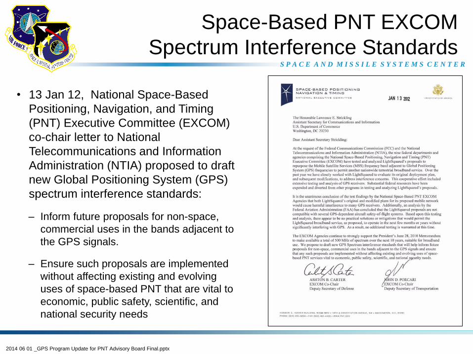
• 13 Jan 12, National Space-Based
Positioning, Navigation, and Timing
(PNT) Executive Committee (EXCOM)
co-chair letter to National
Telecommunications and Information
Administration (NTIA) proposed to draft
new Global Positioning System (GPS)
spectrum interference standards:
– Inform future proposals for non-space,
commercial uses in the bands adjacent to
the GPS signals.
– Ensure such proposals are implemented
without affecting existing and evolving
uses of space-based PNT that are vital to
economic, public safety, scientific, and
national security needs
Space-Based PNT EXCOM
Spectrum Interference Standards
2014 06 01 _GPS Program Update for PNT Advisory Board Final.pptx
S P A C E A N D M I S S I L E S Y S T E M S C E N T E R
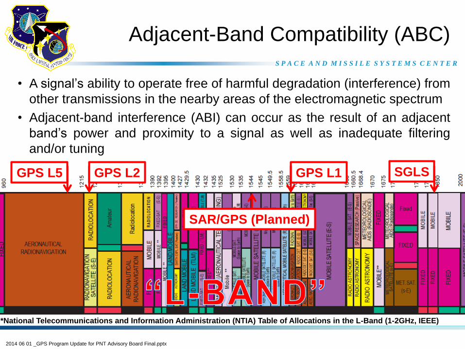
• A signal’s ability to operate free of harmful degradation (interference) from
other transmissions in the nearby areas of the electromagnetic spectrum
• Adjacent-band interference (ABI) can occur as the result of an adjacent
band’s power and proximity to a signal as well as inadequate filtering
and/or tuning
Adjacent-Band Compatibility (ABC)
GPS L1 GPS L5 GPS L2
*National Telecommunications and Information Administration (NTIA) Table of Allocations in the L-Band (1-2GHz, IEEE)
SGLS
SAR/GPS (Planned)
2014 06 01 _GPS Program Update for PNT Advisory Board Final.pptx
S P A C E A N D M I S S I L E S Y S T E M S C E N T E R
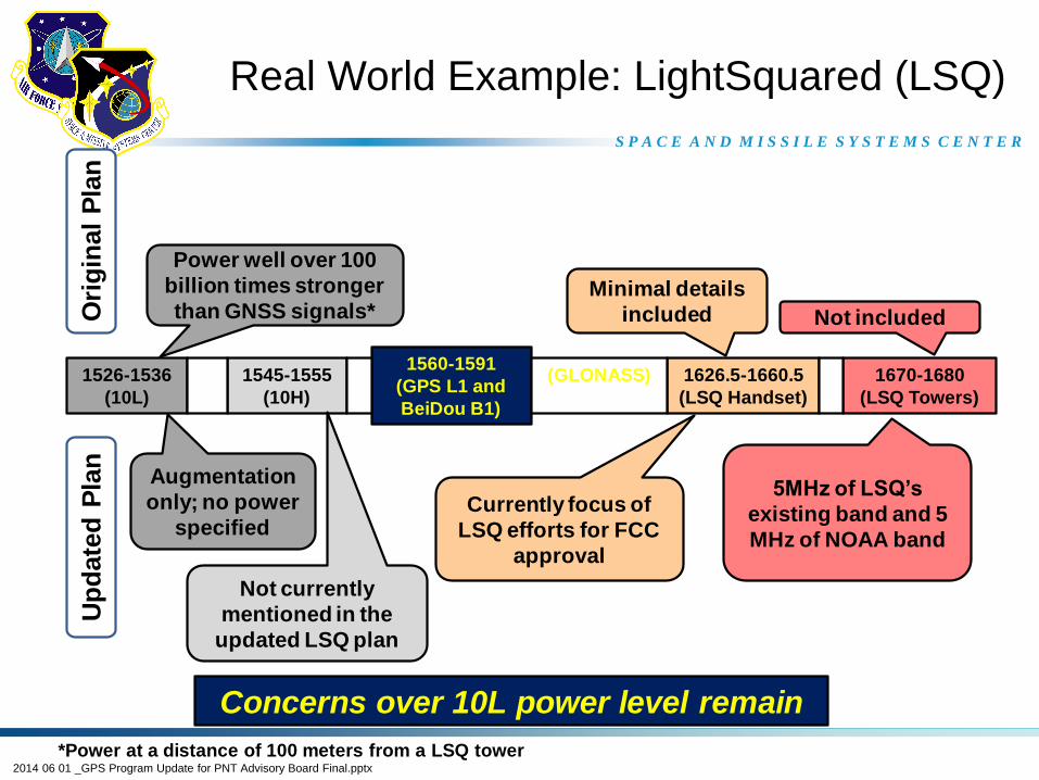
• LightSquared (LSQ) – a company seeking to develop a 4G LTE wireless
broadband system using a block of frequencies adjacent to GPS
• Timeline of LSQ evolution:
– 2001 – Mobile Satellite Ventures (Satcom only with desire for ATC)
– 2004 – FCC authorized Satcom with Ancillary Terrestrial Component (ATC)
– Jan 2011 – FCC granted conditional waiver to offer increased terrestrial 4G service
(40K ATC) only if harmful interference to GPS was resolved
– Feb 2011 – Oct 2011 – Testing commences and LSQ begins to modify their operational
plan as the results indicate negative impacts to GPS
– Nov 2011 – Jan 2012 – Further testing and analysis is conducted on the various changes
being made to the LSQ plan
– Feb 2012 – NTIA memo to FCC declaring that LSQ will impact GPS services and that
there is no practical method for mitigation at this time
– 14 May 12 – LSQ filed for bankruptcy
– Present – LSQ bankruptcy decisions on-going; handset plan moving forward with
concerns expressed from Department of Transportation and other US federal agencies
LightSquared Background
2014 06 01 _GPS Program Update for PNT Advisory Board Final.pptx
S P A C E A N D M I S S I L E S Y S T E M S C E N T E R
Real World Example: LightSquared (LSQ)
Power well over 100
billion times stronger
than GNSS signals*
1526-1536
(10L)
1560-1591
(GPS L1 and
BeiDou B1)
1545-1555
(10H)
1626.5-1660.5
(LSQ Handset)
(GLONASS) 1670-1680
(LSQ Towers)
Augmentation
only; no power
specified
Not currently
mentioned in the
updated LSQ plan
*Power at a distance of 100 meters from a LSQ tower
Ori
gin
al
Pla
nU
pd
ate
d P
lan
5MHz of LSQ’s
existing band and 5
MHz of NOAA band
Currently focus of
LSQ efforts for FCC
approval
Minimal details
included Not included
Concerns over 10L power level remain


![[sv] Validity date from LAND Marocko 00258 [SV] SECTION … · 2020. 5. 22. · 1 / 35 LAND [SV] SECTION Marocko Fiskeriprodukter [sv] Validity date from 10/08/2007 [sv] Date of publication](https://img.pdfslide.us/doc/110x75/5fbce723db71870cc10035f6/sv-validity-date-from-land-marocko-00258-sv-section-2020-5-22-1-35-land.jpg)