Embed Size (px)
Citation preview

GPS Capabilities and Future GPS Capabilities and Future ProductsProducts
Robert E. Wolf, Randy K.TaylorBiological and Agricultural Engineering Dept.
Kansas State University

The Influence of Precision Agriculture!

Today’s Focus: GPS Guidance Systems

Enabling Technology
GPS (Global Positioning System)
Increased computing power in smaller packages

What is GPS?
GPS is a navigation system that uses satellites overhead, a differential reference station to correct for error, computers and modems to communicate location and calculate where you are in relation to a location map.
GIS - Preprogrammed or real-time information is processed for tillage, seeding, nutrient applications and spraying.

Why GPS Guidance?
Increase productivity by minimizing overlap and skips and reducing inputs: save chemical, fuel, and time
Reduce operator fatigue and increase efficiency More accurate & productive navigation Eliminate the need for foam markers Timely application: extend hours of operation for
tillage, seeding, and spraying Accurate application in low visibility conditions:
day or night, dust or fog, no-till stubble

This is old aerial technology!

Major Issues
CompatibilityAccuracy
• GPS• Operator Interface
Features/AbilitiesCost

Compatibility
Can it communicate with other devices?• Computers• Controllers
Can it serve multiple functions?• Guidance• GPS for yield monitor• Data logging
How are data logged (recorded) and stored? What data can be recorded and stored?

GPS Accuracy
Can the receiver tell you where you are?• Absolute accuracy
Can the receiver actually tell you where you are relative to where you have been?• Relative accuracy or precision
What is the response time? How quick is it?

Position Accuracy
No standard procedures or tests for dynamic (moving) accuracy
Manufacturers use their own definitions of static accuracy
Short term static accuracy can be quite good
Dynamic accuracy is thought to be better than static accuracy

Differential Correction
Coast Guard Beacon
WAAS (Wide Area Augmentation System)
Single FrequencyDual Frequency

GPS Updates
Update Rate - How fast (often) is signal or position updated?
Faster updates generally mean better accuracy
5-10 Hz (times per second) is generally sufficient
Some receivers update at 1 Hz

Operator Interface
GPS accuracy is irrelevant if the operator cannot interpret the signal and make timely steering corrections
Two basic designs• Light based• Image based

Light Based Interface
Uses lights to indicate what the operator should do to maintain the desired path

Image Based Interface
Uses an image of the vehicle and an indication of where the vehicle should be

Features and Abilities
Straight line guidance• Back and forth or racetrack
patterns
Contour guidance• Curved swaths
Return to a point• Stopped spraying to refill and
want to restart where you left off

Straight Line Guidance
Set an A-B line in a location that you can drive straight
Other passes are relative to the initial A-B line

Contour Guidance
Drive any pass – possibly along a terrace
Each subsequent pass is parallel to the previous pass

Systems and Costs
Low cost guidance – add guidance to currently owned system• $100 - $1500
Purchase stand alone guidance system• $4000 - $10000
Auto Steer Systems• $12,000 - $50,000

Auto Steering
Trimble AgGPS® Autopilot
BEELINE Navigator• AGCO Challenger
IntegriNautics

Autonomous Vehicles:

Tomorrow’s Focus: Spray applications:

Pulsed Emissions from Nozzles
Pulse Width Modulation - PWM

Synchro Nozzles
Blended Pulse Technology Independent Flow Control (1-8X) Independent Drop Size Control Independent Band Width Control
(Fan Nozzles) Separate boom section controls GPS - program management
control


Accountability map for Field run 7 - wind speed and wind direction
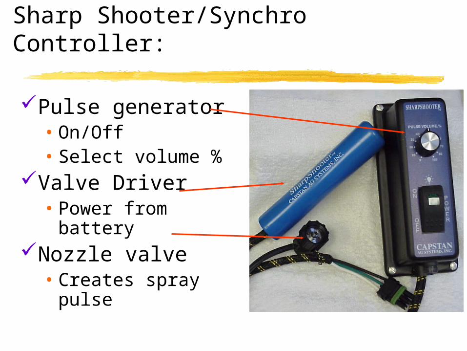
Sharp Shooter/Synchro Controller:
Pulse generator• On/Off• Select volume %
Valve Driver• Power from battery
Nozzle valve• Creates spray pulse

Remote Sensing Imaging:
Low altitude or satellite Near real-time Developing maps of pest problems Variable rate applications Spot spraying

Geo-referenced Field NIR Image:

Yield Maps & Remote Sensing:
1997 Yield MapAerial Photo 6/18/97

Remote Controlled HelicoptersSpraying and Video Scouting:

Managing Crop Nitrogen Inputs:
N-Sensor Operates on-the-go Measures light
reflectance from the crop Calculates Nitrogen
deficiencies Translates to an
application system to apply the required amount of ‘N’ where needed

Smart Sprayers
Computer guided Vision systems on sprayers
Real-time ID weeds, insects,
diseasesDetermine where,
what, and when to spray
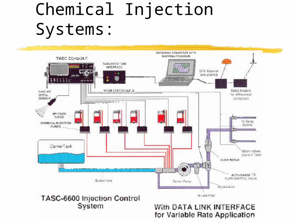
Chemical Injection Systems:

Injection Systems

Recent Alliances
Raven – BeeLine-Farmworks (TruLine)
Spray Systems – Trimble???