Embed Size (px)
Citation preview
Tan et al., Cogent Engineering (2017), 4: 1326199https://doi.org/10.1080/23311916.2017.1326199
ELECTRICAL & ELECTRONIC ENGINEERING | RESEARCH ARTICLE
GPS-based highway toll collection system: Novel design and operationJin Yeong Tan1, Pin Jern Ker1*, Dineis Mani1 and Puvanesan Arumugam1
Abstract: The requirement for vehicles to halt for toll fee payment results in traf-fic congestion and reduces fuel efficiency. In this paper, hardware and software designs were involved to develop a GPS-based highway toll collection system. The system utilised the Raspberry Pi 2 as the microcontroller. Additional electronic mod-ules such as GPS module, LCD module, speaker, wireless Wi-Fi router modem and wireless Wi-Fi adapter were included to perform specific tasks. The system utilised GPS coordinates to track vehicle and toll fees were incurred at predefined points. The travel summary was recorded in the online database. Furthermore, an automatic delay time adjustment system was studied and was implemented to reduce the power consumption of the system without compromising the accuracy. A personal cloud server was configured to allow online access of travel logs. The developed system promises motorists a smooth travel journey and eliminates the construction of expensive toll booths.
Subjects: Electronics; Systems & Controls; Radar & Navigation
Keywords: embedded system; GPS; microcontroller; Raspberry Pi; toll collection
1. IntroductionRoad pricing or tolling can be defined as the practice of fee collection from motorists who use road-way facilities (U.S. Department of Transportation Federal Highway Administration, n.d.). The col-lected toll fees are often used for expansion, operational and maintenance purposes. Traditionally, toll fee was manually collected via cash or card transactions at dedicated toll booths. However, this
*Corresponding author: Pin Jern Ker, Institute of Power Engineering, College of Engineering, Universiti Tenaga Nasional, 43000 Kajang, Selangor, MalaysiaE-mail: [email protected]
Reviewing editor:Mohammed Chadli,University of Picardie Jules Verne, France
Additional information is available at the end of the article
ABOUT THE AUTHORSThe research group focuses on systems and machines intelligence which includes intelligent sensing and detection, microcontroller-based applications, infrared sensing applications and optical sensor technologies. The researchers are also interested in the application of artificial intelligence in decision making and classification for systems monitoring and control. There are a few ongoing projects such as those related to intelligent transformer insulating oil monitoring, developing portable surveillance system with intrusion alert notification, face recognition system, intelligent sensing for undersea power cables and developing software for electricity theft detection.
PUBLIC INTEREST STATEMENTThe practice of road pricing or tolling has constantly posed challenges from the perspectives of road user experience and system implementation. Manual toll collections cause peak hour congestions, whereas modern electronic toll collections are often associated with high construction and maintenance costs. This paper aims to seek a viable solution by proposing road pricing based on the Global Positioning System (GPS). A GPS-based highway toll collection system was developed by equipping a microcontroller with third-generation (3G) and GPS connectivity. The constant acquisition of GPS coordinates acted as the basis to track travelling vehicle and to perform all necessary toll collections. With additional works to improve the overall system accuracy and reliability, the proposed system can easily be commercialised as a future toll collection technology.
Received: 15 February 2017Accepted: 30 April 2017First Published: 04 May 2017
© 2017 The Author(s). This open access article is distributed under a Creative Commons Attribution (CC-BY) 4.0 license.
Page 1 of 10
Page 2 of 10
Tan et al., Cogent Engineering (2017), 4: 1326199https://doi.org/10.1080/23311916.2017.1326199
system was often criticised as motorists were required to stop to pay the fees. The stopping of vehi-cles results in traffic congestion at the toll booths during peak hours and have been proven to result in fuel inefficiency.
To effectively address the complications from manual toll collection, electronic toll collection (ETC) was proposed. The idea was originated from the Nobel Economics Prize winner, William Vickrey, who suggested to equip all cars with an electronic identifier (Library Economics Liberty, n.d.). The elec-tronic identifier refers to a transponder that allows personalized signal to be delivered to a central computer from specific road sections for bill calculation (Kelly, 2006). This idea was first adopted at toll booths in Norway in the year 1986. By 1991, Trondheim in Norway became the world’s first city that implemented the unaided full-speed electronic tolling (ONE-ITS, n.d.). This system is advanta-geous as it significantly reduced time delay due to toll payment. As popularity grew with this con-cept, gantries gradually replaced the traditional toll booths, allowing sensors to be installed for easier detection.
Unfortunately, from here, additional issues were raised in response to gantry usage. First, gantry constructions are expensive. Next, gantry breakdown may disrupt toll collection and regular main-tenance is thus necessary. A possible solution to these issues is to implement road pricing based on the Global Positioning System (GPS). The earliest project on GPS-based road pricing was accompa-nied with a field test in Hong Kong in 1997 (Catling, 2000). In 1998, the European Union published a report that proposed the usage of Global Navigation Satellite System (GNSS) to charge vehicles by distance (Brussels, 1998). These early works gave rise to more concepts and variations of GPS-based road pricing. Lee, Jeng, Tseng, and Wang (2004) and Xu (2005) both provided comprehensive inves-tigations and reviews on the architecture of GPS-based toll collection system as well as addressing possible design issues. Srinivasan, Cheu, and Tan (2003) proposed a GPS-based road pricing system using map matching method. Moreover, Ren and Xu (2010) proposed another system rooted upon node matching. Not least, Dias, Matos, and Oliveira (2014) came up with the concept of a smart-phone-based toll collection system which was interoperable between traditional ETC and new GNSS tolling. Interesting as these concepts may seem, their implementations, however, require sophisti-cated algorithms and complex system setup, resulting in commercialisation challenges. Hence, through this research, we demonstrate for the first time that a GPS-based highway toll collection system which can be easily commercialised can be developed using a microcontroller with third-generation (3G) and GPS connectivity.
In this paper, details of the experimental setup will be provided. Next, the results of the developed GPS-based highway toll collection system will be discussed, enlisting the general operation of the system. Further experiments and analysis were carried out using the developed prototype in order to incorporate additional features that produced a more robust and highly efficient system.
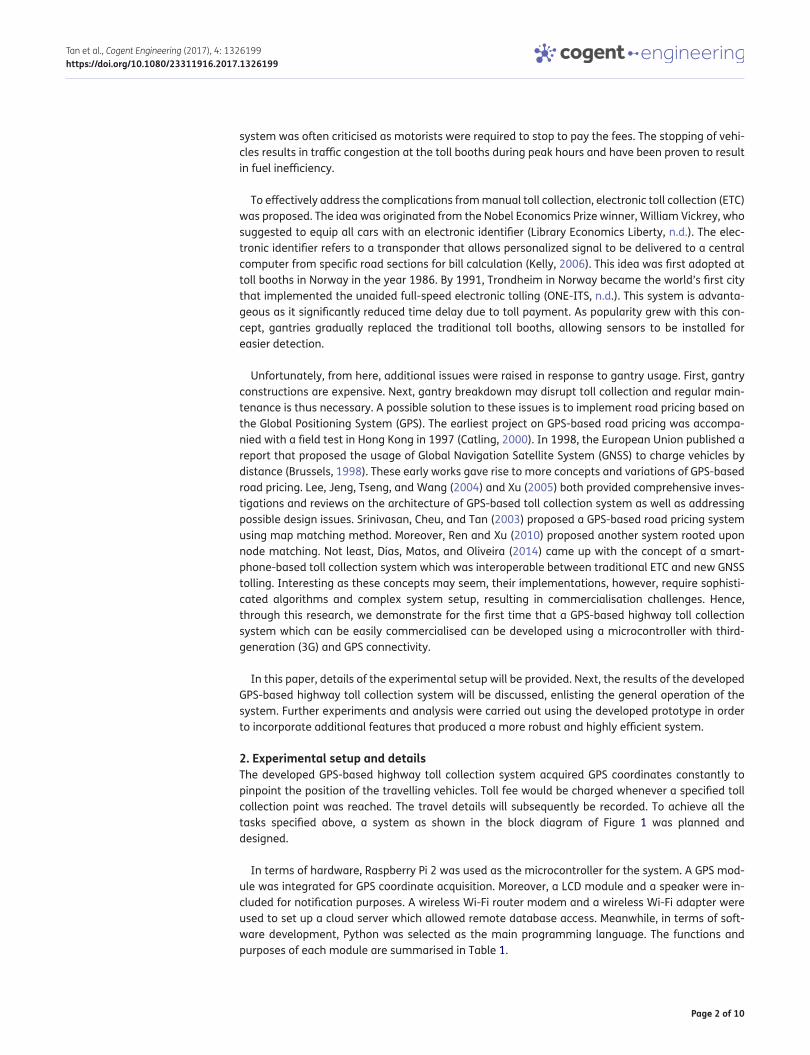
2. Experimental setup and detailsThe developed GPS-based highway toll collection system acquired GPS coordinates constantly to pinpoint the position of the travelling vehicles. Toll fee would be charged whenever a specified toll collection point was reached. The travel details will subsequently be recorded. To achieve all the tasks specified above, a system as shown in the block diagram of Figure 1 was planned and designed.
In terms of hardware, Raspberry Pi 2 was used as the microcontroller for the system. A GPS mod-ule was integrated for GPS coordinate acquisition. Moreover, a LCD module and a speaker were in-cluded for notification purposes. A wireless Wi-Fi router modem and a wireless Wi-Fi adapter were used to set up a cloud server which allowed remote database access. Meanwhile, in terms of soft-ware development, Python was selected as the main programming language. The functions and purposes of each module are summarised in Table 1.
Page 3 of 10
Tan et al., Cogent Engineering (2017), 4: 1326199https://doi.org/10.1080/23311916.2017.1326199
2.1. System configurationRaspberry Pi 2 was the microcontroller chosen for this project upon considering factors such as pro-cessing speed, capability as mini server and communication methods. This microcontroller ran on Raspbian, a Debian-based operating system (OS) optimised for Raspberry Pi hardware. The Raspbian OS was chosen since it contains a large numbers of mature packages and pre-compiled software which can perform various tasks (Raspbian, n.d.). The Raspbian image was first flashed into a 32 GB micro-SD card. The micro-SD card was then inserted into the microcontroller to be loaded.
The GPS module utilised in this project was the Adafruit Ultimate GPS Hat module (Adafruit, n.d.). Several microcontroller boot options were modified before the GPS module could be utilised (Pi GPS Setup, n.d.). These modifications were done to the cmdline.txt and inittab files which enabled access to the Rx and Tx pins of the microcontroller for GPS data receiving.
Furthermore, an additional Global Positioning System Daemon (GPSD) package was installed. This package was used to translate the raw serial data from the GPS module into a system of variables which was easier for programming purposes (Use ‘gpsd’, n.d.).
Moreover, a 16 × 2 character LCD module was included in the GPS-based highway toll collection system to provide notification on toll location and pricing information. The LCD module was inter-faced with the Raspberry Pi 2 microcontroller via GPIO pins using the Inter-Integrated Circuit (I2C) protocol. In order to access the LCD module, the I2C kernel has to be installed in the microcontroller (Setting up your Pi for I2C, n.d.). Upon installation of the I2C kernel, the I2C settings on the microcon-troller were configured and the secondary I2C pins of the microcontroller were enabled (Setting up your Pi for I2C, n.d.).
In addition, a speaker was included for user alert purposes. The speaker was connected to the AUX jack of the microcontroller. The notification audio files stored in the /home/pi/tonido/ folder of the
Figure 1. Block diagram of GPS-based highway toll collection system.
Table 1. Module functionsModule FunctionMicrocontroller Coordinates activities of the GPS-based highway toll collection system
GPS module Acquires GPS coordinates of moving vehicle
LCD module Displays notification on toll location and pricing information
speaker Audio notification on toll collection and lock state of vehicle
Wireless Wi-Fi router modem Establishes a wireless 3G connection from an unlocked SIM card
Wireless Wi-Fi adapter Enables the microcontroller to connect to the established 3G connection
Page 4 of 10
Tan et al., Cogent Engineering (2017), 4: 1326199https://doi.org/10.1080/23311916.2017.1326199
microcontroller were delivered through the analogue jack of the microcontroller by pulling the out-put to high (Getting Audio Out Working on the Raspberry Pi, n.d.).
Not least, several structured query language (SQL) databases were established for the highway toll collection system. These databases aimed to store the information of all toll destinations and record the travel history of users. Usage of SQL databases was made possible by installing the SQLite application in the microcontroller (Riley, n.d.).
Three databases were created using a windows-based software called the DB Browser for SQLite (n.d.). The databases were
(1) database.sqlite
This database contained general information of predefined toll destinations such as location name, coordinate and toll pricing.
(2) sql.sqlite
This database logged the travel of users by recording the toll destinations passed through, time of travel and payment incurred.
(3) speed.sqlite
This database recorded the time of travel, coordinate and speed of vehicle when speed limit was exceeded.
The created database files were stored in the /home/pi/tonido/ folder of the microcontroller.
Lastly, a cloud server was established to provide remote access to the travel logs stored in the SQL database. The set-up of the cloud server required a wireless Wi-Fi router modem and a wireless Wi-Fi adapter. The D-LINK DWR-710 wireless Wi-Fi router modem (D-Link, n.d.) was inserted with a SIM card to establish a wireless 3G connection. Meanwhile, the Edimax EW-7811Un wireless Wi-Fi adapter (Edimax, n.d.) was attached to the microcontroller to allow access to the established 3G network.
The cloud server software adopted was the Tonido Cloud Server application (Tonido, n.d.). Upon installation, account setup was done at the Tonido website through the URL http://<RaspberryPi IP Address>:10001. The Tonido Cloud Server application was configured to run automatically on micro-controller boot by installing the Tonido init.d script in the /etc./init.d folder of the microcontroller.
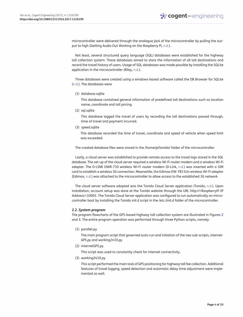
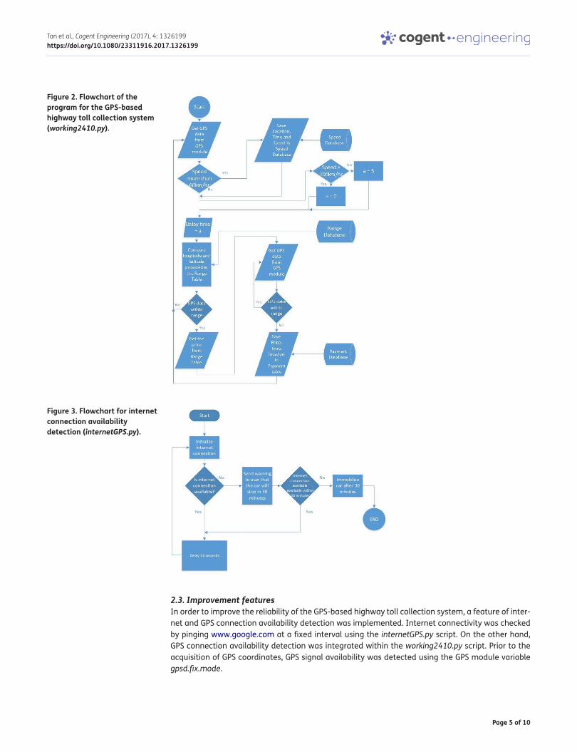
2.2. System programThe program flowcharts of the GPS-based highway toll collection system are illustrated in Figures 2 and 3. The entire program operation was performed through three Python scripts, namely:
(1) parallel.py
The main program script that governed auto-run and initiation of the two sub-scripts, internet-GPS.py and working2410.py.
(2) internetGPS.py
This script was used to constantly check for internet connectivity.
(3) working2410.py
This script performed the main task of GPS positioning for highway toll fee collection. Additional features of travel logging, speed detection and automatic delay time adjustment were imple-mented as well.
Page 5 of 10
Tan et al., Cogent Engineering (2017), 4: 1326199https://doi.org/10.1080/23311916.2017.1326199
2.3. Improvement featuresIn order to improve the reliability of the GPS-based highway toll collection system, a feature of inter-net and GPS connection availability detection was implemented. Internet connectivity was checked by pinging www.google.com at a fixed interval using the internetGPS.py script. On the other hand, GPS connection availability detection was integrated within the working2410.py script. Prior to the acquisition of GPS coordinates, GPS signal availability was detected using the GPS module variable gpsd.fix.mode.
Figure 2. Flowchart of the program for the GPS-based highway toll collection system (working2410.py).
Figure 3. Flowchart for internet connection availability detection (internetGPS.py).
Page 6 of 10
Tan et al., Cogent Engineering (2017), 4: 1326199https://doi.org/10.1080/23311916.2017.1326199
Moreover, a feature of automatic delay time adjustment was included to allow accurate location detection without consuming too much power from the microcontroller. An analysis was done along the South Klang Valley Expressway, Putrajaya, Malaysia, which allowed a maximum longitudinal displacement. GPS coordinates were acquired at no delay, 5 and 10 s delay while the vehicle trav-elled at speeds between 0 and 80 km/hr. The results were plotted and analysed to determine the optimum delay time relative to travel speed.
3. Results and discussion
3.1. Availability of internet and GPS connectionThe availability of internet and GPS connectivity was vital for the operation of the GPS-based high-way toll collection system. Hence, internet and GPS connections were detected before system operation.
Internet connection was checked using the internetGPS.py script. The script functioned by pinging www.google.com at 15 s intervals. If a ping was not replied, the script concluded that no internet access was available and the user was warned. In case the condition retained for a minute, an alarm audio will then be played.
GPS connectivity was detected using the working2410.py script. The script utilised the gpsd.fix.mode variable of the GPS module to perform the detection. When the gpsd.fix.mode variable re-corded a value of 1, it indicated that the GPS module did not receive sufficient data for coordinate pinpointing and the user was notified.
The unavailability of internet and GPS connectivity alerts users on possible faults in the highway toll collection system in cases where connectivity is not detected over a long travel distance. Moreover, data on signal availability can even aid road planners in assigning toll collection points since areas with poor internet and GPS signals can now be avoided.
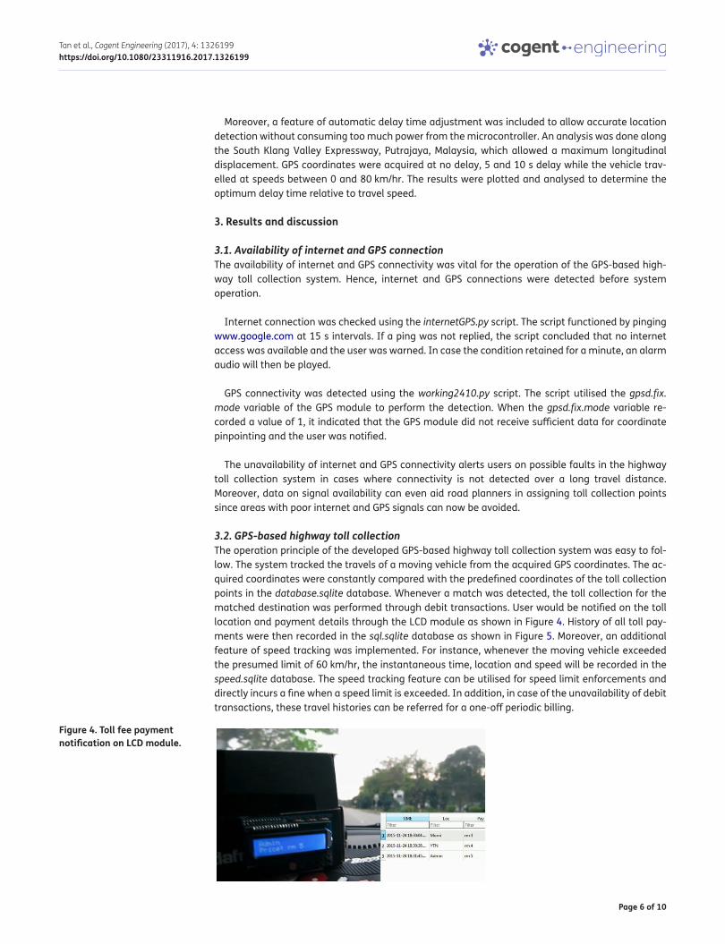
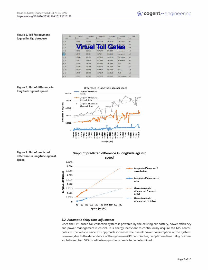
3.2. GPS-based highway toll collectionThe operation principle of the developed GPS-based highway toll collection system was easy to fol-low. The system tracked the travels of a moving vehicle from the acquired GPS coordinates. The ac-quired coordinates were constantly compared with the predefined coordinates of the toll collection points in the database.sqlite database. Whenever a match was detected, the toll collection for the matched destination was performed through debit transactions. User would be notified on the toll location and payment details through the LCD module as shown in Figure 4. History of all toll pay-ments were then recorded in the sql.sqlite database as shown in Figure 5. Moreover, an additional feature of speed tracking was implemented. For instance, whenever the moving vehicle exceeded the presumed limit of 60 km/hr, the instantaneous time, location and speed will be recorded in the speed.sqlite database. The speed tracking feature can be utilised for speed limit enforcements and directly incurs a fine when a speed limit is exceeded. In addition, in case of the unavailability of debit transactions, these travel histories can be referred for a one-off periodic billing.
Figure 4. Toll fee payment notification on LCD module.
Page 7 of 10
Tan et al., Cogent Engineering (2017), 4: 1326199https://doi.org/10.1080/23311916.2017.1326199
3.2. Automatic delay time adjustmentSince the GPS-based toll collection system is powered by the existing car battery, power efficiency and power management is crucial. It is energy inefficient to continuously acquire the GPS coordi-nates of the vehicle since this approach increases the overall power consumption of the system. However, due to the dependence of the system on GPS coordinates, an optimum time delay or inter-val between two GPS coordinate acquisitions needs to be determined.
Figure 5. Toll fee payment logged in SQL database.
Figure 6. Plot of difference in longitude against speed.
Figure 7. Plot of predicted difference in longitude against speed.
Page 8 of 10
Tan et al., Cogent Engineering (2017), 4: 1326199https://doi.org/10.1080/23311916.2017.1326199
This optimum time delay was governed by the automatic delay time adjustment scheme. The methodology for the analysis of the automatic delay time adjustment scheme was discussed in Section 2.3 and the results were presented in Figure 6. From the plotted data, it can be observed that an increase in acquisition time delay led to greater longitudinal differences. Hence, to accommodate for low power consumption and accurate positioning, a 5 s delay was appropriate. However, this delay incurred inaccuracies when vehicles were moving at high speeds. Extrapolation was done with the collected data to predict longitudinal differences in response to speed changes as seen in Figure 7. From this extrapolation, the automatic delay time adjustment scheme was proposed at a speed threshold of 100 km/h to maintain an acceptable longitudinal deviations. In short, at a speed below 100 km/h, a 5 s delay will be introduced for GPS coordinate acquisitions. Alternatively, at a speed above 100 km/h, no delay will be introduced for coordinate acquisitions.
3.3. Commercialisation values and considerationsThe proposed GPS-based highway toll collection system exhibited great potential for commercialisa-tion. The proposed toll collection system has low power requirements and operates at 5 V. This op-erating voltage allows easy integration into existing car electronic circuitry that runs on 12 V. Moreover, the hardware components adopted in this prototype are matured technologies and are at reasonable cost. This cost is anticipated to be even lower upon commercialisation due to economies of scale. Not least, the installation of the toll collection system will not affect the overall user driving experience. The miniature box design takes up minimum space and allows the system to be installed on the vehicle’s dashboard, preserving the driver’s line-of-sight and granting the best GPS signalling.
Despite the simple system installation stated earlier, several possible limitations should be care-fully addressed. Firstly, the developed GPS-based highway toll collection system may register inac-curate toll collection when roads overlap due to the presence of flyovers or parallel roads in a highway structure. The issue of road overlapping can be solved by strategically allocating toll collec-tion points at locations that minimise the tendency of road overlapping. A hardware upgrade may be implemented as well by replacing the GPS module with a Differential Global Positioning System (DGPS) module of higher accuracy at the expense of higher cost. Furthermore, the presence of two-way traffic flow may result in complications during the implementation of the GPS-based highway toll collection system. It is highly recommended to assign equal toll fees for both traffic directions to avoid incorrect charges due to slight location deviations. The practice of referring to previous travel coordinates prior to toll collection can also aid in identifying vehicle travel direction and ensure ac-curate toll fee collection.
In addition, sudden breakdown of the GPS-based highway toll collection system which results in the failure to acquire internet and GPS signals should be taken into account. Future works may in-clude a redundant distance measurement circuitry to ensure proper toll collection in case the main system fails. Lastly, the reliability of the established cloud server should be improved prior to product commercialisation. Based upon the small-scale cloud server in this paper, additional works should be done in expanding server capacity to support wide user pools. Apart from scaling, cloud server security should be tackled by introducing encryption measures which shield the server from hacking attempts and potential user information leaks. Adding to these, the establishment and mainte-nance of such a reliable cloud server should be ensured to be economically feasible.
4. ConclusionThe GPS-based highway toll collection system was developed from a combination of electronic com-ponents such as Raspberry Pi 2 microcontroller, GPS module, LCD module, Wi-Fi adapter, wireless router modem and speaker. GPS coordinates were used to trace vehicle travels and collect toll fees at predefined toll collection points. Toll-incurred travels were then recorded in the SQL database. The system was equipped with additional features of 3G internet and GPS connection availability detec-tion as well as automatic delay time adjustment. Moreover, a personal cloud server was established to allow remote access to travel logs stored in the SQL database. An automatic time delay
Page 9 of 10
Tan et al., Cogent Engineering (2017), 4: 1326199https://doi.org/10.1080/23311916.2017.1326199
adjustment in GPS coordinate acquisition was successfully implemented by carrying out a compre-hensive investigation on the time delay and the changes in GPS coordinate. This feature would re-duce the power consumption of the system significantly. This developed system is beneficial as it eliminates travel delays and the construction of expensive gantries or toll booths. In addition, the system may be utilised as a unique digital identity for each vehicle, promoting expansion into the area of car security and ownership transfer.
FundingThis work was supported in part by the Malaysian Ministry of Education and Universiti Tenaga Nasional under the Fundamental Research Grant Scheme (FRGS) [grant number 20140122FRGS] and UNITEN Internal [grant number J510050608].
Author detailsJin Yeong Tan1
E-mail: [email protected] ID: http://orcid.org/0000-0001-9154-4537Pin Jern Ker1
E-mail: [email protected] ID: http://orcid.org/0000-0002-5703-1735Dineis Mani1
E-mail: [email protected] ID: http://orcid.org/0000-0002-5183-4019Puvanesan Arumugam1
E-mail: [email protected] ID: http://orcid.org/0000-0002-1990-27391 Institute of Power Engineering, College of Engineering,
Universiti Tenaga Nasional, 43000 Kajang, Selangor, Malaysia.
Citation informationCite this article as: GPS-based highway toll collection system: Novel design and operation, Jin Yeong Tan, Pin Jern Ker, Dineis Mani & Puvanesan Arumugam, Cogent Engineering (2017), 4: 1326199.
ReferencesAdafruit Ultimate GPS Breakout – 66 channel w/10 Hz updates
– Version 3. (n.d.). Retrieved July 7, 2015, from https://www.adafruit.com/product/746
Brussels. (1998, July 22). Fair payment for infrastructure use: A phased approach to a common transport infrastructure charging framework in the EU. Commission of the European Communities White Paper.
Catling, I. (2000). Road user charging using vehicle positioning systems. In Proceeding of IEEE International Conference on Road Transport Information and Control (pp. 126–130). London: IEEE. https://doi.org/10.1049/cp:20000118
DB Browser for SQLite. (n.d.). Retrieved December 4, 2015, from http://sqlitebrowser.org/
Dias, J., Matos, J. N., & Oliveira, A. S. R. (2014). The charge collector system: A new NFC and smartphone-based toll collection system. Procedia Technology, 17, 130–137. https://doi.org/10.1016/j.protcy.2014.10.220
D-Link. (n.d.). DWR-710 Le Petit HSPA+ Router. Retrieved August 8, 2015 from http://www.dlinkmea.com/partner/media/product_item_downloadables/6314-DWR-710_B1_Datasheet_01(HQ).pdf
Edimax. (n.d.). EW-7811Un 150Mbps Wireless IEEE802.11b/g/n nano USB adapter. Retrieved August 10, 2015, from http://www.edimax.com/au/support_detail.php?pd_id=347&pl1_id=1&pl2_id=
Getting Audio Out Working on the Raspberry Pi. (n.d.). Retrieved November 17, 2015 from https://jeffskinnerbox.wordpress.com/2012/11/15/getting-audio-out-working-on-the-raspberry-pi/
Kelly, F. (2006). Road pricing: Addressing congestion, pollution and the financing of Britain's road. Ingenia, 29, 34–40.
Lee, W. H., Jeng, B. S., Tseng, S. S., & Wang, C. H. 2004. Electronic toll collection based on vehicle-positioning system techniques. In Proceeding of IEEE International Conference on Networking, Sensing and Control (pp. 643–648). Taiwan: IEEE.
Library Economics Liberty. (n.d.). The concise encyclopedia of economics: William S. Vickrey. Retrieved October 17, 2015, from http://www.econlib.org/library/Enc/bios/Vickrey.html
ONE-ITS. (n.d). Electronic toll collection. Retrieved February 3, 2016, from http://one-its-webapp1.transport.utoronto.ca/web/one-its/wiki;jsessionid=7C99D8A6AC36686CC7DF838F8F4E8A4C?p_p_id=54_INSTANCE_rWJ5&p_p_lifecycle=0&p_p_state=normal&p_p_mode=view&p_p_col_id=column-1&p_p_col_count=1&_54_INSTANCE_rWJ5_struts_action=%2Fwiki_display%2Fview&_54_INSTANCE_rWJ5_nodeName=Main&_54_INSTANCE_rWJ5_title=Electronic+Toll+Collection
Pi GPS Setup. (n.d.) Retrieved November 17, 2015 from https://learn.adafruit.com/adafruit-ultimate-gps-hat-for-raspberry-pi/pi-setup
Raspbian. (n.d.). Welcome to Raspbian. Retrieved August 8, 2015, from https://www.raspbian.org/
Ren, D., & Xu, A. (2010, June). Research on intelligent road pricing system based on GPS/GIS integrated technology. In Proceeding of 18th International Conference on Geoinformatics (pp. 1–4). IEEE.
Riley, A. (n.d.). Getting started with Databases on the Pi with SQLite. Retrieved December 2, 2015, from http://www.raspberrypiblog.com/2012/11/getting-started-with-databases-on-pi.html
Setting up your Pi for I2C. (n.d.). Retrieved November 17, 2015, from https://learn.adafruit.com/adafruit-16x2-character-lcd-plus-keypad-for-raspberry-pi/usage
Srinivasan, D., Cheu, R. L., & Tan, C. W. (2003, October). Development of an improved ERP system using GPS and AI techniques. In Proceeding of Intelligent Transportation Systems, 1, 554–559.
Tonido. (n.d.). Tonido & TonidoPlug User Manual. Retrieved January 12, 2016, from http://www.tonido.com/support/display/docs/Homsse
U.S. Department of Transportation Federal Highway Administration. (n.d.). Road pricing defined. Retrieved October 17, 2015, from http://www.fhwa.dot.gov/ipd/revenue/road_pricing/defined/
Use ‘gpsd’. (n.d.). Retrieved November 17, 2015, from https://learn.adafruit.com/adafruit-ultimate-gps-hat-for-raspberry-pi/use-gpsd
Xu, A. (2005). Research on a new GPS/GIS based ERP system. In Proceeding of IEEE International Conference on Intelligent Transportation Systems (pp. 455–457). IEEE.

Page 10 of 10
Tan et al., Cogent Engineering (2017), 4: 1326199https://doi.org/10.1080/23311916.2017.1326199
© 2017 The Author(s). This open access article is distributed under a Creative Commons Attribution (CC-BY) 4.0 license.You are free to: Share — copy and redistribute the material in any medium or format Adapt — remix, transform, and build upon the material for any purpose, even commercially.The licensor cannot revoke these freedoms as long as you follow the license terms.
Under the following terms:Attribution — You must give appropriate credit, provide a link to the license, and indicate if changes were made. You may do so in any reasonable manner, but not in any way that suggests the licensor endorses you or your use. No additional restrictions You may not apply legal terms or technological measures that legally restrict others from doing anything the license permits.
Cogent Engineering (ISSN: 2331-1916) is published by Cogent OA, part of Taylor & Francis Group. Publishing with Cogent OA ensures:• Immediate, universal access to your article on publication• High visibility and discoverability via the Cogent OA website as well as Taylor & Francis Online• Download and citation statistics for your article• Rapid online publication• Input from, and dialog with, expert editors and editorial boards• Retention of full copyright of your article• Guaranteed legacy preservation of your article• Discounts and waivers for authors in developing regionsSubmit your manuscript to a Cogent OA journal at www.CogentOA.com