Embed Size (px)
Citation preview

SB 2012
House Appropriations
Government Operations Division
Supplemental Material
Friday March 12, 2021
1
Index for SB 2012 House Appropriations
Supplemental Material
March 12, 2021
1. NDDOT Funding – Revenue Chart
2. Summary of Federal COVID Funding - Transportation & Aeronautics
3. Summary of Federal COVID Funding – NDDOT (Losses from Traffic Reduction)4. Transit CARES Act Funding - Statewide Transit Recipients
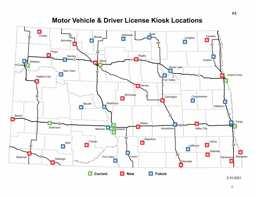
5. Map - Kiosk Locations
6. Kiosk Services – Phased Implementation Plan Outline7. Environmental Transportation Services Regional Service Area Map – Mitigation Bank Locations
8. Wetland Banking and Mitigation – White Paper
9. Wetland Bank Process
10. NDDOT Wetland Mitigation – Public Brochure
2
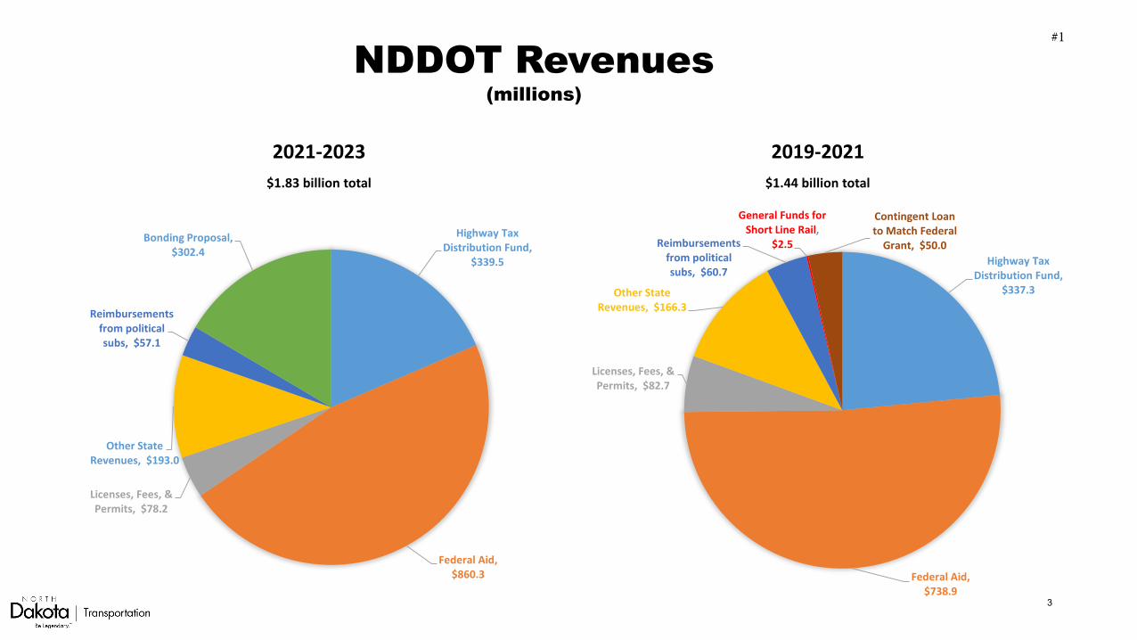
NDDOT Revenues(millions)
2021-2023$1.83 billion total
2019-2021$1.44 billion total
Highway Tax Distribution Fund,
$339.5
Federal Aid, $860.3
Licenses, Fees, & Permits, $78.2
Other State Revenues, $193.0
Reimbursements from political subs, $57.1
Bonding Proposal, $302.4
Highway Tax Distribution Fund,
$337.3
Federal Aid, $738.9
Licenses, Fees, & Permits, $82.7
Other State Revenues, $166.3
Reimbursements from political subs, $60.7
General Funds for Short Line Rail,
$2.5
Contingent Loan to Match Federal
Grant, $50.0
#1
3
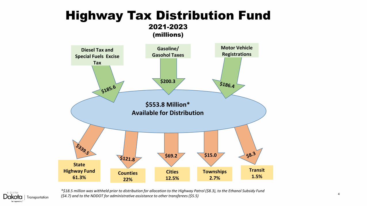
Highway Tax Distribution Fund2021-2023
(millions)
Gasoline/Gasohol Taxes
Motor Vehicle Registrations
Diesel Tax and Special Fuels Excise
Tax
$553.8 Million*Available for Distribution
$200.3
State Highway Fund
61.3%Counties
22%Cities12.5%
Townships2.7%
Transit1.5%
$69.2 $15.0
*$18.5 million was withheld prior to distribution for allocation to the Highway Patrol ($8.3), to the Ethanol Subsidy Fund ($4.7) and to the NDDOT for administrative assistance to other transferees ($5.5) 4

DepartmentPublic Law Citation
P.L. 116-136, Div. B Title XII
P.L. 116-260, Div. M, Title IV
P.L. 116-136, Div. B Title XII
P.L. 116-260, Div. M, Title IV
P.L. 116-136, Div. B Title XII
P.L. 116-260, Div. M, Title IV
P.L. 116-260, Div. M, Title IV
P.L. 116-260, Div. M, Title IV
P.L. 116-260, Div. M, Title IV
CFDA 20.507+ 20.507+ 20.509+ 20.509+ 20.106+ 20.106+ 20.513 20.513 20.205
ProgramFTA Urbanized
Formula*
FTA Urbanized Formula
(CRRSAA)*
FTA Nonurbanized
Formula*
FTA Nonurbanized
Formula (CRRSAA)*
FAA Grants-in-Aid for
Airports*
FAA Airport Coronavirus
Response Grant Program*
FTA Enhanced Mobility of Seniors
and Persons with Disabilities - State*
FTA Enhanced Mobility of Seniors
and Persons with Disabilities - Local
FHWA Surface Transportation
Block Grant*
Transportation
Maryland 676,497 244,179 19,821 9,105 107,731 26,605 279 N/A 149,195Massachusetts 1,031,263 335,806 12,620 7,262 171,048 41,022 179 N/A 150,832Michigan 279,603 86,822 73,187 55,426 256,959 55,842 716 N/A 261,309Minnesota 253,769 192,057 54,432 14,697 158,379 42,072 348 N/A 161,774Mississippi 24,790 722 49,702 0 34,855 11,623 277 N/A 119,928Missouri 194,464 80,917 61,771 0 152,485 34,344 449 N/A 234,760Montana 14,331 0 35,455 0 73,822 20,035 166 N/A 101,763Nebraska 34,666 505 27,109 0 64,603 12,540 106 N/A 71,690Nevada 139,514 65,222 21,789 0 231,448 49,628 71 N/A 90,149New Hampshire 24,976 3,186 13,773 0 15,224 7,152 172 N/A 41,001New Jersey 1,738,866 1,465,128 13,322 0 160,900 47,540 131 N/A 247,953New Mexico 97,142 2,047 36,474 0 25,230 11,574 214 N/A 91,073New York 4,078,792 4,110,110 71,645 6,494 411,274 122,739 589 N/A 416,895North Carolina 224,825 83,611 94,941 0 283,707 74,503 782 N/A 258,737North Dakota 15,075 0 17,996 0 85,020 13,168 115 N/A 61,585Ohio 396,068 192,424 81,932 0 108,807 32,911 680 N/A 332,673Oklahoma 55,422 0 51,393 387 42,203 15,199 294 N/A 157,253Oregon 242,343 220,807 42,686 2,455 140,163 31,942 335 N/A 123,981Pennsylvania 1,059,411 457,326 80,602 0 239,220 55,628 804 N/A 407,152Rhode Island 102,466 9 1,917 579 24,017 6,175 10 N/A 54,256South Carolina 78,227 2,524 44,962 0 97,263 23,270 494 N/A 166,038South Dakota 11,628 0 22,495 0 36,249 10,242 130 N/A 69,956Tennessee 164,119 9,581 65,633 0 124,092 43,875 602 N/A 209,619Texas 1,036,496 426,269 143,201 0 811,535 196,630 1,361 N/A 967,734Utah 197,208 33,584 22,313 4,964 93,363 30,570 102 N/A 86,132Vermont 7,682 2,481 13,328 26,725 9,000 4,133 90 N/A 50,361Virginia 403,872 222,130 52,527 0 309,729 66,379 484 N/A 252,480
Estimated State Funding for Coronavirus Pandemic-Updated March 9, 2021$'s in the thousands
#2
5
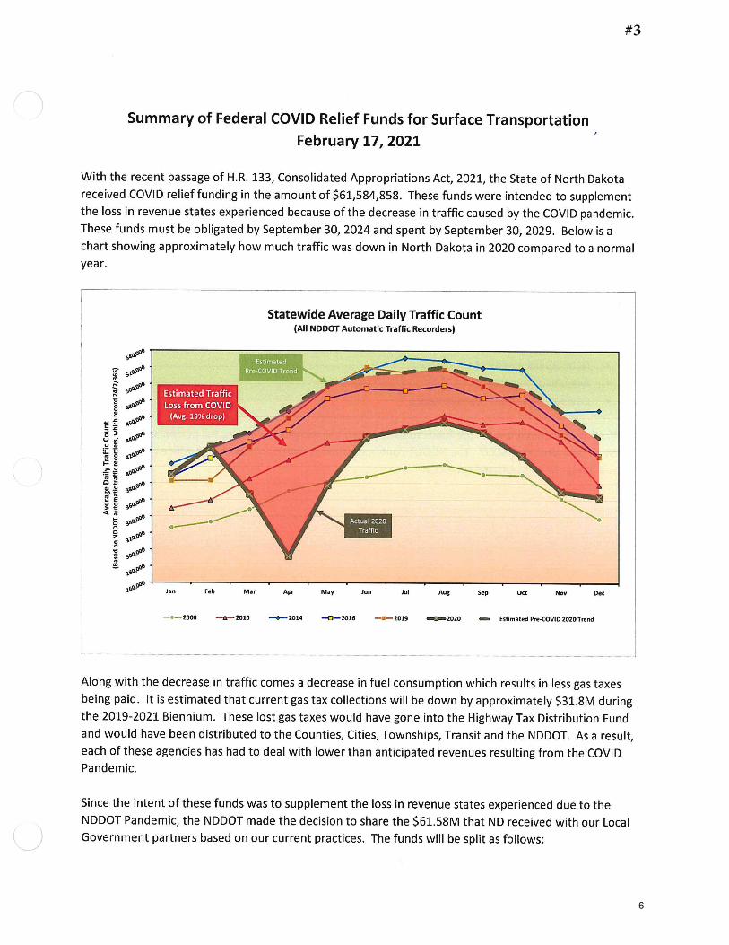
#3
6
7
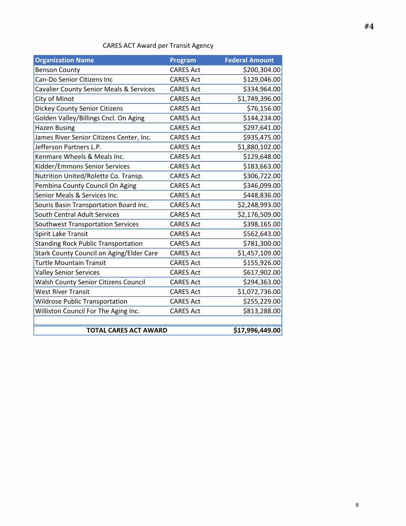
Organization Name Program Federal Amount
Benson County CARES Act $200,304.00
Can-Do Senior Citizens Inc CARES Act $129,046.00
Cavalier County Senior Meals & Services CARES Act $334,964.00
City of Minot CARES Act $1,749,396.00
Dickey County Senior Citizens CARES Act $76,156.00
Golden Valley/Billings Cncl. On Aging CARES Act $144,234.00
Hazen Busing CARES Act $297,641.00
James River Senior Citizens Center, Inc. CARES Act $935,475.00
Jefferson Partners L.P. CARES Act $1,880,102.00
Kenmare Wheels & Meals Inc. CARES Act $129,648.00
Kidder/Emmons Senior Services CARES Act $183,663.00
Nutrition United/Rolette Co. Transp. CARES Act $306,722.00
Pembina County Council On Aging CARES Act $346,099.00
Senior Meals & Services Inc. CARES Act $448,836.00
Souris Basin Transportation Board Inc. CARES Act $2,248,993.00
South Central Adult Services CARES Act $2,176,509.00
Southwest Transportation Services CARES Act $398,165.00
Spirit Lake Transit CARES Act $562,643.00
Standing Rock Public Transportation CARES Act $781,300.00
Stark County Council on Aging/Elder Care CARES Act $1,457,109.00
Turtle Mountain Transit CARES Act $155,926.00
Valley Senior Services CARES Act $617,902.00
Walsh County Senior Citizens Council CARES Act $294,363.00
West River Transit CARES Act $1,072,736.00
Wildrose Public Transportation CARES Act $255,229.00
Williston Council For The Aging Inc. CARES Act $813,288.00
TOTAL CARES ACT AWARD $17,996,449.00
CARES ACT Award per Transit Agency
#4
8
#5
9
City Location and Addresses of Kiosk Locations
Beach Beach City Community center - 153 E. Main St
Bismarck Kirkwood MallStamart Travel Center - off I-94 at exit 161Motor Vehicle Office in the NDDOT Transportation Building
Bowman Frontier Travel Center
Carrington Leevers Foods - 176 4th Ave S
Carson Grant County Recorder - 106 2nd Ave NE
Cavalier Do-It-Best - 500 Division Ave S
Crosby Jason’s Super Foods - 211 Main St S
Dickinson Cash Wise Store - 1761 3rd Ave W
Ellendale Fresh Market - 121 1st St N
Fargo Stamart Travel Center - off I-29 at exit 66 West
Gwinner One Stop - 8 N Main St, Gwinner
Grand Forks Cities Mall - 1726 S Washington St Stamart Travel Center - off I-29 / Highway 2 at exit 141
Hankinson Post’s Hardware - 613 Main Ave S
Harvey Hinrichs Supervalu
Hettinger Kum & Go - 308 Adams Ave
Kenmare Farmers Union Oil Co. - 49211 Hwy 52 N
Lisbon Lisbon Treasurer - 204 5th Ave W
McClusky Post Office - 220 Main St S
Minot Cash Wise Store - 3208 16th St SWMarketplace Foods – 1600 2nd Ave SW
Napoleon City Hall - 225 W Lake Ave
Rugby Home of economy - 225 Us Highway 2
Steele Steele Travel Plaza - 620 Mitchell Ave N
Tioga Cashwise - 802 N Elm St
Valley City Petro Serve USA - 1020 8th Ave SW
Wahpeton Chamber Office - 1505 11th St N, Wahpeton
Watford City Watford City Treasurer - 201 5th St NW
Williston Cash Wise Store - 300 11th St W
3-10-2021
#1#5#5
10
Kiosk Project with ITI
New Services Rollout
2021
This document is intended to assist with the rollout of the 16 new services being implemented on the kiosks. A short
description for each group is included.
• 30 Day Temp Reg (MV) (already in production)
• Schedule a driving test (DL)
• Pay Reinstatement Fee (DL)
• Request administrative hearing (DL)
• Online Driver License Renewal (DL)
o *NOTE: Includes CDL renewal while FMCSA waiver remains, it is set to expire 5/31/21.
• Request a replacement License or ID card (DL)
• MV Address Change (MV)
• MV Email Maintenance (MV)
• DL Address Change (DL)
• Donor Registry (DL) – Sign up to be a donor
• DL Status Check (DL) – Enter Driver ID and receive a status on the screen
• DL Date of Birth Check (DL) – Validate DOB on screen
• CDL Medical Certification Status Check (DL) – Check Med Cert Status which will display on screen
• Non-Resident Temp Reg (MV)
• Mobility Impaired Placard Renewal (MV)
• Online Driving Record (DL)
#6
11
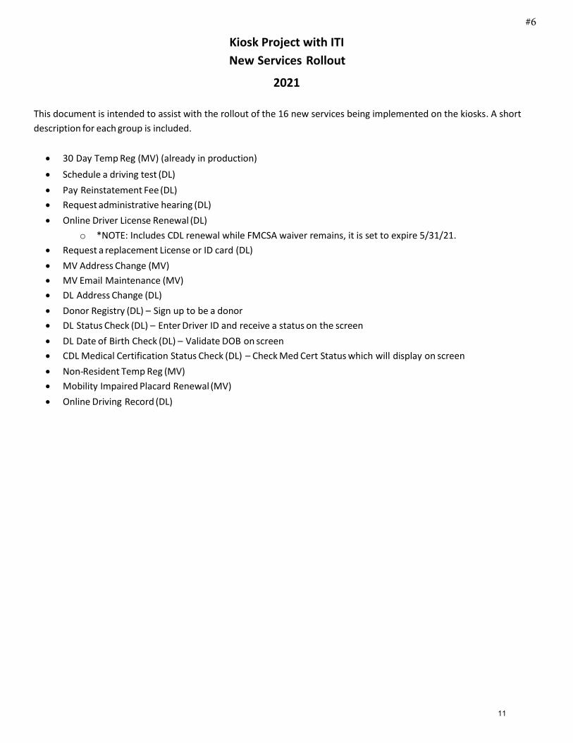
Manning Mitigation Bank27.95 USACE / FHWA Credits
Kirkeby - Schuster Mitigation Bank64.05 USACE / FHWA Credits
Vollrath 15/21 Mitigation Bank6.42 FHWA Credits8.48 USFWS Easement Wetland Credits
Herda Mitigation Bank7.35 USACE / FHWA Credits
Sully's Hill Mitigation Bank52.65 USFWS Fee Grassland Credits3.26 USFWS Fee Wetland Credits
Kueber I Mitigation Bank9.18 USACE / FHWA Credits
Kueber II Mitigation Bank - Proposed
Anderson I Mitigation Bank44.44 FHWA Credits160 USFWS Easement Grassland Credits22.93 USFWS Easement Wetland Credits
Koenig Mitigation Bank - Proposed
Anderson II Mitigation Bank - ProposedSchrenk Mitigation Bank - CRP 2022
Foss Mitigation Bank13.22 USACE / FHWA Credtis
Trego Mitigation Bank3.45 USACE / FHWA Credits
Golden Valley
Foster Griggs
Ransom
McIntosh Sargent
Renville
Steele
Sheridan
Grand Forks
Oliver
Eddy
Hettinger
PembinaRolette
LaMoure
Bowman Adams
Towner
Nelson
Billings
Logan
Mercer
Ramsey
Richland
Dickey
Traill
Pierce
Emmons
BottineauBurkeCavalier
Benson
Sioux
Burleigh
Divide
Walsh
Slope
Mountrail
BarnesKidder
McHenry
Wells
StutsmanStark
Williams
Morton
Grant
McLean
McKenzie
Cass
Dunn
Ward
Bowman Mitigation Bank - CRP 2022
Ward
Dunn
Cass
McKenzie
McLean
Grant
Morton
Williams
StarkStutsman
Wells
McHenry
Kidder Barnes
Mountrail
Slope
Walsh
Divide
Burleigh
Sioux
Benson
CavalierBurke Bottineau
Emmons
Pierce
Traill
Dickey
Richland
Ramsey
Mercer
Logan
Billings
Nelson
Towner
AdamsBowman
LaMoure
Rolette Pembina
Hettinger
Eddy
Oliver
Grand Forks
Sheridan
Steele
Renville
SargentMcIntosh
Ransom
GriggsFoster
Golden Valley
0 25 50 75Miles
4Regional Service Areas
Devils Lake BasinMissouri River Basin NorthMissouri River Basin SouthRed River BasinSouris River BasinSouthwest Slope
Mitigation Type!( USACE and 11990" USACE and 11990 - In Progress!( USFWS and 11990
North Dakota Department of Transportation Environmental and Transportation Services Division
December 2020
Regional Service Area Map #7
12

WHITE PAPER Wetland Banking and Mitigation
December 31, 2020
Introduction
Highway improvements and other public works infrastructure projects have the potential to result in unavoidable impacts to wetlands. In many cases these impacts require compensatory mitigation for the loss of wetlands. Compensatory mitigation is required by federal agencies with jurisdiction or oversight of the wetlands such as the US Army Corps of Engineers (USACE), the US Fish and Wildlife Service (USFWS), or the Federal Highway Administration (FHWA). State, county, and city projects may require compensatory mitigation for wetland impacts. Specifically, mitigation is required by USC 33 Navigable Waters – Section 404 of the Clean Water Act for federal and state projects and 23 CFR 777 Mitigation of Impacts to Wetlands and Natural Habitat for federally funded projects. Mitigation is obtained under the general authority of NDCC 24-01-18.
Background
Compensatory mitigation may be provided in one of three methods as follows:
1) Mitigation banking is the restoration of drained wetlands; creation of newwetlands; or enhancement or preservation of existing wetlands in advance of anyimpacts. Once the bank is approved, compensatory mitigation credits can simplybe deducted from the mitigation bank sponsor’s ledger in order to authorize orpermit construction.
Mitigation banking is the preferred option for providing compensatory mitigation. Mitigation banks have higher probabilities of success; have the lower costs/credit; are more easily monitored and maintained; do not pose an issue for future roadway construction or maintenance operations; can be used for any federal or state project within the regional service area, and provide a higher ecological resource value.
Developing a mitigation bank requires working with a willing landowner to provide a protective easement (deed restrictions) or by purchase; securing interagency approval of the bank plan (see Wetland Banking Oversight); constructing the restoration project; and monitoring to ensure wetland establishment. Management of the bank is provided by either the landowner or by separate agreements when the bank is purchased. A mitigation bank may be purchased, and a management plan developed jointly with the North Dakota Game and Fish Department (NDGFD).
Mitigation banks generally provide better environmental function and are more cost efficient than individual on-site mitigation sites scattered along the roadways across the state.
#8
13
2) In-lieu fee programs involve a governmental or non-governmental naturalresource management organization which finds and develops mitigation banksand then sell mitigation credits. Entities needing compensatory mitigationprovide payment to the organization in return for mitigation credits. Governmentalentities may use in-lieu fee programs if the entity benefits (NDCC 54-01-29).
3) Permittee responsible mitigation, referred to at the NDDOT as on-sitemitigation, typically involves the creation or expansion of an existing wetland of aspecific wetland acreage at various locations on or near the project site, typicallyin NDDOT right of way (ROW).
Wetland Bank Oversight The United States Army Corps of Engineers (USACE) established a review team, the North Dakota Interagency Review Team (NDIRT), to review, approve and oversee the management and operation of proposed compensatory mitigation. In North Dakota, the team consists of representatives from the USACE, U.S. Environmental Protection Agency (USEPA), USFWS, Natural Resources Conservation Service (NRCS), and NDGFD. The agencies provided written guidance titled Wetland Mitigation Banking in North Dakota – Interagency Guidance for Mitigation Bank Sponsors. Ultimately the USACE makes the final decision on whether or not to approve the proposed compensatory mitigation after their solicitation for comment period has ended.
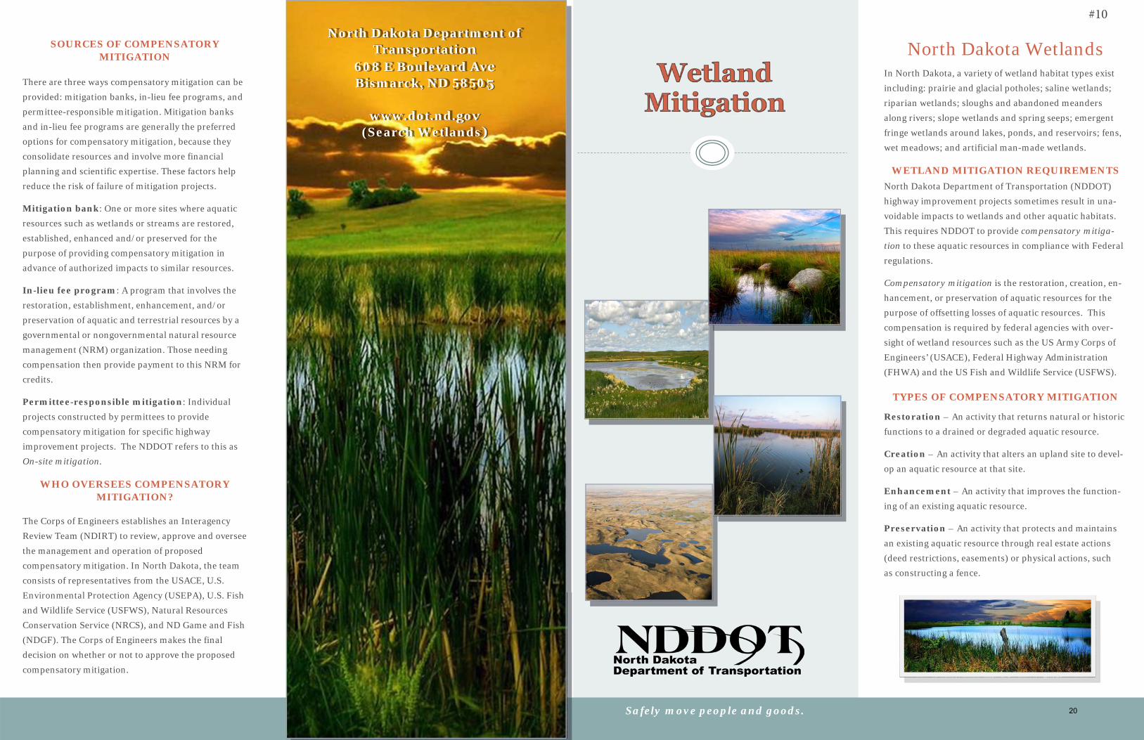
Wetland Bank Information Enclosed is a “Wetland Mitigation Brochure” that has more information regarding the NDDOT wetland mitigation program.
In the magenta box located in the top center of pages 3-4 of the pamphlet, you will see a map of NDDOT mitigation banks throughout the state and the regional service areas. A regional service area is a geographic area of the state where banked credits can be used to compensate for project losses that occur in same regional service area. North Dakota has six regional service areas as outlined in the Wetland Mitigation Banking in North Dakota – Interagency Guidance for Mitigation Bank Sponsors. The regional service areas were agreed upon by NDIRT at the time of developing the “Wetland Mitigation Banking in North Dakota-Interagency Guidance for Mitigation Bank Sponsors” document.
Also, in the green box located in the lower center of pages 3-4 of the pamphlet, you will see a comparison of costs per credit of mitigation banks by regional service areas. The costs per credit typically range from about $15,000 to $22,000, except for the southwest slope which is discussed further below. When using cost comparisons, it is important to note, a credit is not necessarily equivalent to acre. Additionally, costs may vary depending on which party pays for construction and maintenance. Costs shown are from 2018.
14
For impacts in the southwest slope regional service area, the NDDOT performs on-site mitigation, as a bank has not been obtained. On-site mitigation varies considerably, and costs range from about $40,000 to $70,000 per credit to as high as $120,000 per credit. The higher costs occur due to the need to create wetland sites in upland areas that require earth moving to create a basin. In general, the cost per credit to perform compensatory mitigation in western North Dakota is significantly higher than the eastern part of the state because of the lower density of wetlands and reduced hydrology. In general, compensatory mitigation using mitigation banks is more economical than using on-site mitigation.
The acre to credit ratio for mitigation banking is included in the blue box located in the lower right of pages 3-4 of the pamphlet. This shows the credit ratios for restoration, creation, buffer, upland, and preservation, as outlined in the Wetland Mitigation Banking in North Dakota – Interagency Guidance for Mitigation Bank Sponsors. This ratio helps understand the benefit and value of restoring drained wetlands versus preservation of existing wetlands. Restoration provides the highest return or best value.
The cost per credit is comprised of several main components when determining wetland mitigation value.
• First, is land value or the difference in value of the land associated with thechange in use, e.g. from cropland to pasture.
• Second, is value based on wetland restoration and preservation.
• Third, is a value based on upland / grassland preservation.
• Additional costs include engineering, construction, monitoring, etc.
These three values are determined individually, then are added together, and then the total costs are divided by the available credits to determine the cost per credit. The restoration and preservation values are derived from other programs such as the wetland reserve easements offered though the NRCS and wetland easements offered through the USFWS, as well as actual payments for wetland mitigation.
NDDOT compensatory mitigation is a federal eligible activity – meaning federal funding covers about eighty percent of the costs, with the remaining 20 percent being state or local match. On-site mitigation is typically coordinated as part of a highway improvement project. A mitigation bank is typically constructed as a stand-alone project and credits are debited on a project by project basis.
Enclosed is a “Regional Service Area Map” showing the NDDOT Wetland Mitigation Bank locations within the regional services areas and approximate credits for each. As can be observed by the location of the banks, the NDDOT has more banks in the eastern portion of the state.
15
NDDOT Wetland Bank Process All banks require the long-term protection of the aquatic resources by the use of deed restrictions or easement agreements Sites are chosen based on suitability to support the anticipated wetland functional needs. The NDDOT establishes dialogue with the NDIRT and USACE during the early planning stages to inform them of the interest in a parcel of land. NDDOT then conducts a full office review, field analysis, and cost appraisal of the proposed mitigation bank site and proposes it to NDIRT. Upon approval by NDIRT and USACE, the property interest is purchased, and the bank is designed and constructed.
Finally, when the wetland bank is completion, credits are released for use on transportation projects that result in impacts. Enclosed is a “NDDOT Wetland Banking Process Summary” that identifies the detailed steps in developing a wetland bank.
Landowner Obligations by Wetland Mitigation Agreement The landowner is responsible for the following items per agreement:
• Pays taxes and assessments on property,
• Controls noxious weeds,
• Cannot make modification to the wetlands, buffer area, or adjacent wetlands,
• Cannot allow the destruction of vegetation root structure by digging, plowing, ordisking,
• Cannot plant or harvest crops,
• Cannot hay or mow until after July 15,
• Cannot store equipment or other property on the easement tract,
• Cannot participate in fee hunting,
Challenges to Developing a Wetland Bank
• Political pressure to reduce the conversion of farmland,
• Identifying willing landowners with drained wetlands,
• Identifying commensurate compensation for loss of production and duration ofthe 99-year easement,
• Developing a wetland bank takes a substantial amount of time, generally 1 to 3years,
• Competition for wetland mitigation credits by various programs requiringcompensatory mitigation and by developers.
• Obtaining final approval from the USACE.
• Minimizing project impacts so that bank credits are used efficiently.
• Having dedicated staff to wetland banking
NDDOT Staffing and Activity Resourcing Staffing should require at least one full time equivalent (FTE) to be effective in developing the banks needed for NDDOT highway improvement projects. Additional supporting resources are needed for surveys, right of way plats, property valuations, negotiations, etc. All the work needs to be coordinated with, and approval by the Federal agencies working with the NDIRT and USACE.
16
Currently, one FTE, environmental scientist, is working about twenty five percent of their time on wetland banking projects and the other supporting work is resourced by tasking internal project development staff or consulting service agreements. This arrangement results in an extended development period.
Additional staffing for wetland bank development is necessary for an increased highway improvement program or if additional Local Public Agency (LPA) projects are included in the NDDOT mitigation program. This assumes the LPA’s utilize minimization measures prior to determining mitigation.
Additional staffing should include 1-FTE Environmental Scientist for Wetland Banking and 1-FTE for Wetland Delineations and Permitting.
Advertising for Wetland Bank Opportunities Generally, the Wetland Mitigation Banking brochure is distributed at public meetings and to interested parties by staff and consultants working on transportation improvement projects. As such, a number of wetland mitigation banks have been developed through these contacts, by other agency referrals, and by landowner referrals. Advertisement of wetland mitigation opportunities on a broader basis (such as NDDOT staff participating in farm shows, conferences, etc.) was discouraged because of the negative views associated with the conversion of the land. It was believed that land prices driven in part on the government funding associated with the wetland banks created an unfair advantage to the agricultural use of the land.
Enclosures
NDDOT Wetland Mitigation Brochure Regional Service Area Map NDDOT Wetland Banking Process Summary
19/msg
17
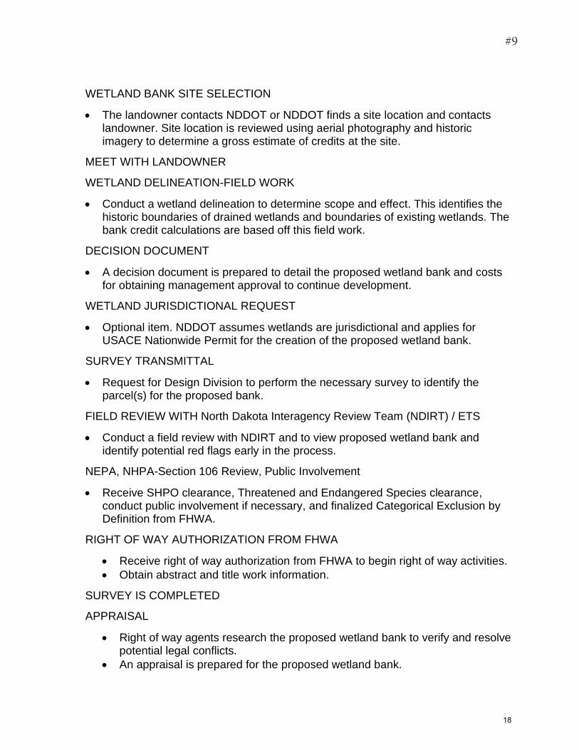
WETLAND BANK SITE SELECTION
• The landowner contacts NDDOT or NDDOT finds a site location and contactslandowner. Site location is reviewed using aerial photography and historicimagery to determine a gross estimate of credits at the site.
MEET WITH LANDOWNER
WETLAND DELINEATION-FIELD WORK
• Conduct a wetland delineation to determine scope and effect. This identifies thehistoric boundaries of drained wetlands and boundaries of existing wetlands. Thebank credit calculations are based off this field work.
DECISION DOCUMENT
• A decision document is prepared to detail the proposed wetland bank and costsfor obtaining management approval to continue development.
WETLAND JURISDICTIONAL REQUEST
• Optional item. NDDOT assumes wetlands are jurisdictional and applies forUSACE Nationwide Permit for the creation of the proposed wetland bank.
SURVEY TRANSMITTAL
• Request for Design Division to perform the necessary survey to identify theparcel(s) for the proposed bank.
FIELD REVIEW WITH North Dakota Interagency Review Team (NDIRT) / ETS
• Conduct a field review with NDIRT and to view proposed wetland bank andidentify potential red flags early in the process.
NEPA, NHPA-Section 106 Review, Public Involvement
• Receive SHPO clearance, Threatened and Endangered Species clearance,conduct public involvement if necessary, and finalized Categorical Exclusion byDefinition from FHWA.
RIGHT OF WAY AUTHORIZATION FROM FHWA
• Receive right of way authorization from FHWA to begin right of way activities.
• Obtain abstract and title work information.
SURVEY IS COMPLETED
APPRAISAL
• Right of way agents research the proposed wetland bank to verify and resolvepotential legal conflicts.
• An appraisal is prepared for the proposed wetland bank.
#9
18

PRELIMINARY PLATS COMPLETED
DRAFT SITE PLAN COMPLETED
• A site plan is drafted and reviewed internally. The “final draft” is sent to NDIRT forpreliminary comments.
FINAL PLATS COMPLETED
NEGOTIATION AND ACQUISITION
FINAL MITIGATION SITE PLAN IS APPROVED BY NDIRT/USACE
• -Final approval by USACE comes with an additional 30 public comment period.
MITIGATION SITE PROJECT PLANS ARE COMPLETED
19
North Dakota Department of Transportation
608 E Boulevard Ave Bismarck, ND 58505
www.dot.nd.gov (Search Wetlands)
Safely move people and goods.
North Dakota Wetlands In North Dakota, a variety of wetland habitat types exist
including: prairie and glacial potholes; saline wetlands;
riparian wetlands; sloughs and abandoned meanders
along rivers; slope wetlands and spring seeps; emergent
fringe wetlands around lakes, ponds, and reservoirs; fens,
wet meadows; and artificial man-made wetlands.
WETLAND MITIGATION REQUIREMENTS North Dakota Department of Transportation (NDDOT)
highway improvement projects sometimes result in una-
voidable impacts to wetlands and other aquatic habitats.
This requires NDDOT to provide compensatory mitiga-tion to these aquatic resources in compliance with Federal
regulations.
Compensatory mitigation is the restoration, creation, en-
hancement, or preservation of aquatic resources for the
purpose of offsetting losses of aquatic resources. This
compensation is required by federal agencies with over-
sight of wetland resources such as the US Army Corps of
Engineers’ (USACE), Federal Highway Administration
(FHWA) and the US Fish and Wildlife Service (USFWS).
TYPES OF COMPENSATORY MITIGATION
Restoration – An activity that returns natural or historic
functions to a drained or degraded aquatic resource.
Creation – An activity that alters an upland site to devel-
op an aquatic resource at that site.
Enhancement – An activity that improves the function-
ing of an existing aquatic resource.
Preservation – An activity that protects and maintains
an existing aquatic resource through real estate actions
(deed restrictions, easements) or physical actions, such
as constructing a fence.
SOURCES OF COMPENSATORY MITIGATION
There are three ways compensatory mitigation can be
provided: mitigation banks, in-lieu fee programs, and
permittee-responsible mitigation. Mitigation banks
and in-lieu fee programs are generally the preferred
options for compensatory mitigation, because they
consolidate resources and involve more financial
planning and scientific expertise. These factors help
reduce the risk of failure of mitigation projects.
Mitigation bank: One or more sites where aquatic
resources such as wetlands or streams are restored,
established, enhanced and/or preserved for the
purpose of providing compensatory mitigation in
advance of authorized impacts to similar resources.
In-lieu fee program: A program that involves the
restoration, establishment, enhancement, and/or
preservation of aquatic and terrestrial resources by a
governmental or nongovernmental natural resource
management (NRM) organization. Those needing
compensation then provide payment to this NRM for
credits.
Permittee-responsible mitigation: Individual
projects constructed by permittees to provide
compensatory mitigation for specific highway
improvement projects. The NDDOT refers to this as
On-site mitigation.
WHO OVERSEES COMPENSATORY MITIGATION?
The Corps of Engineers establishes an Interagency
Review Team (NDIRT) to review, approve and oversee
the management and operation of proposed
compensatory mitigation. In North Dakota, the team
consists of representatives from the USACE, U.S.
Environmental Protection Agency (USEPA), U.S. Fish
and Wildlife Service (USFWS), Natural Resources
Conservation Service (NRCS), and ND Game and Fish
(NDGF). The Corps of Engineers makes the final
decision on whether or not to approve the proposed
compensatory mitigation.
#10
20
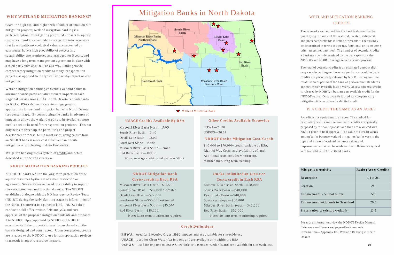
Mitigation Activity Ratio (Acre: Credit)
Restoration 1:1 to 2:1
Creation 2:1
Enhancement - 50 foot buffer 5:1
Enhancement—Uplands to Grassland 20:1
Preservation of existing wetlands 10:1
WETLAND MITIGATION BANKING
CREDITS
The value of a wetland mitigation bank is determined by
quantifying the value of the restored, created, enhanced,
and preserved wetlands in terms of “credits.” Credits may
be determined in terms of acreage, functional units, or some
other assessment method. The number of potential credits
a bank may be is determined by the bank sponsor ( the
NDDOT) and NDIRT during the bank review process.
The total of potential credits is an estimated amount that
may vary depending on the actual performance of the bank.
Credits are periodically released by NDIRT throughout the
establishment period of the bank as performance standards
are met, which typically lasts 5 years. Once a potential credit
is released by NDIRT, it becomes an available credit for the
NDDOT to use. Once a credit is used for compensatory
mitigation, it is considered a debited credit.
IS A CREDIT THE SAME AS AN ACRE?
A credit is not equivalent to an acre. The method for
calculating credits and the number of credits are typically
proposed by the bank sponsor and then are reviewed with
NDIRT prior to final approval. The value of a credit varies
among banks because wetland mitigation banks vary in the
type and extent of wetland resource values and
improvements that can be made to them. Below is a typical
acre to credit ratio for wetland banks.
For more information, view the NDDOT Design Manual
Reference and Forms webpage—Environmental
Information— Appendix E6. Wetland Banking in North
Dakota
WHY WETLAND MITIGATION BANKING?
Given the high cost and higher risk of failure of small on-site
mitigation projects, wetland mitigation banking is a
preferred option for mitigating permitted impacts to aquatic
resources. Banking consolidates mitigation into large sites
that have significant ecological value, are protected by
easements, have a high probability of success and
sustainability, are monitored and managed for 5 years, and
may have a long term management agreement in place with
a third party such as NDGF or USFWS. Banks provide
compensatory mitigation credits to many transportation
projects, as opposed to the typical impact-by-impact on-site
mitigation .
Wetland mitigation banking constructs wetland banks in
advance of anticipated aquatic resource impacts in each
Regional Service Area (RSA). North Dakota is divided into
six RSA’s. RSA’s define the maximum geographic
applicability for wetland mitigation banks in North Dakota
(see center map). By constructing the banks in advance of
impacts, it allows the wetland credits to be available before
credits need to be used for transportation projects. This not
only helps to speed up the permitting and project
development process, but in most cases, using credits from
an NDDOT bank is more cost effective than on-site
mitigation or purchasing In-Lieu Fee credits.
Mitigation banking uses a system of credits and debits
described in the “credits” section.
NDDOT MITIGATION BANKING PROCESS
All NDDOT banks require the long-term protection of the
aquatic resources by the use of a deed restriction or
agreement. Sites are chosen based on suitability to support
the anticipated wetland functional needs. The NDDOT
establishes dialogue with the ND Interagency Review Team
(NDIRT) during the early planning stages to inform them of
the NDDOT’s interest in a parcel of land. NDDOT then
conducts a full office review, field analysis, and cost
appraisal of the proposed mitigation bank site and proposes
it to NDIRT. Upon approval by NDIRT and NDDOT
executive staff, the property interest is purchased and the
bank is designed and constructed. Upon completion, credits
are released to the NDDOT to use for transportation projects
that result in aquatic resource impacts.
Mitigation Banks in North Dakota
Credit Definitions
FHWA —used for Executive Order 11990 impacts and are available for statewide use
USACE —used for Clean Water Act impacts and are available only within the RSA
USFWS —used for impacts to USFWS Fee Title or Easement Wetlands and are available for statewide use.
USACE Credits Available By RSA
Missouri River Basin North—17.05
Souris River Basin — 3.40
Devils Lake Basin — 13.03
Southwest Slope — None
Missouri River Basin South — None
Red River Basin — 109.68
Note: Average credits used per year 50.82
Other Credits Available Statewide
FHWA— 73.30
USFWS— 36.67
NDDOT Onsite Mitigation Cost/Credit
$40,000 to $70,000/credit: variable by RSA,
Right of Way Costs, and availability of land.
Additional costs include: Monitoring,
maintenance, long-term tracking
Wetland Mitigation Bank
NDDOT Mitigation Bank Costs/credit in Each RSA
Missouri River Basin North— $15,500
Souris River Basin — $15,000 estimated
Devils Lake Basin — $22,000
Southwest Slope — $55,000 estimated
Missouri River Basin South — $15,500
Red River Basin — $16,000
Note: Long-term monitoring required
Ducks Unlimited In-Lieu Fee Costs/credit in Each RSA
Missouri River Basin North— $50,000
Souris River Basin — $40,000
Devils Lake Basin — $40,000
Southwest Slope — $60,000
Missouri River Basin South — $40,000
Red River Basin — $50,000
Note: No long-term monitoring required.
21