Embed Size (px)
Citation preview
Government of
Saint Vincent and the Grenadines
Phase 1
Disaster Vulnerability Reduction Project
(DVRP) Social Assessment Report
Central Planning Division, Ministry of Finance and Economic Planning
1st
Floor, Administrative Centre, Bay Street, Kingstown,
St.Vincent and the Grenadines Tel.: 784-457-1746 ● Fax: 784-456-2430 ● E-mail:
Pub
lic D
iscl
osur
e A
utho
rized
Pub
lic D
iscl
osur
e A
utho
rized
Pub
lic D
iscl
osur
e A
utho
rized
Pub
lic D
iscl
osur
e A
utho
rized
Pub
lic D
iscl
osur
e A
utho
rized
Pub
lic D
iscl
osur
e A
utho
rized
Pub
lic D
iscl
osur
e A
utho
rized
Pub
lic D
iscl
osur
e A
utho
rized
St. Vincent and the Grenadines Social Assessment
Disaster Vulnerability Reduction Project
2
Table of Contents
Acronyms and Abbreviations .................................................................................................... 4
Social Indicators ..................................................................................................................... 5
Executive Summary ............................................................................................................... 6
Introduction ............................................................................................................................ 7
Objective of the Disaster Vulnerability Reduction Project ....................................................... 8
Socio-economic profile of St. Vincent and the Grenadines .............................................. 9
Country Description .................................................................................................................. 9
Weather and Climate ................................................................................................................ 9
Population Demographic Factors ........................................................................................... 10
Environment ......................................................................................................................... 11
Density .................................................................................................................................... 11
Livelihood ................................................................................................................................ 11
Health .................................................................................................................................... 11
Education .............................................................................................................................. 12
Disaster vulnerability .......................................................................................................... 12
Social Assessment ................................................................................................................ 14
Consultation Framework ........................................................................................................ 14
Consultation with the community .......................................................................................... 14
Methodology ........................................................................................................................... 15
The Research Methods: ...................................................................................................... 15
Research techniques: .............................................................................................................. 16
PROCESS ................................................................................................................................. 16
Preparation ............................................................................................................................. 17
Data Collection ..................................................................................................................... 18
Sampling and Justification .................................................................................................. 19
Map: Communities where project would be implemented ................................................... 21
Key Social Finding .................................................................................................................... 22
Community Profiles ............................................................................................................. 24
Dark View ............................................................................................................................. 24
Arnos Vale ............................................................................................................................. 25
Colonarie ............................................................................................................................... 26

St. Vincent and the Grenadines Social Assessment
Disaster Vulnerability Reduction Project
3
Sandy Bay .............................................................................................................................. 29
Marriaqua .............................................................................................................................. 32
Georgetown: ............................................................................................................................ 35
Buccament ............................................................................................................................. 36
stakeholder issues ................................................................................................................ 38
stakeholder analysis and consultation .............................................................................. 40
Land Acquisition issues ...................................................................................................... 42
Analysis of Project Impacts................................................................................................. 44
Analysis of Impact Specific Intervention .......................................................................... 46
Coastal Defence .................................................................................................................... 47
Slope Stabilization: ............................................................................................................... 49
Roads and Bridges: .............................................................................................................. 51
Common impact for Slope stabilization, Road and Bridges, coastal and River defence ........ 52
Emergency Communication: Installation of VHF/HF Radios ...................................... 53
Satellite Warehouse ............................................................................................................. 55
Risk assessment ..................................................................................................................... 57
Social Safeguard issues and other social risks ........................................................................ 59
World Bank Safeguard Policies ............................................................................................... 60
Beneficiaries table* ............................................................................................................... 61
Recommendations .................................................................................................................. 71
Monitoring and Evaluation Plan ............................................................................................. 76
Results and Monitoring Framework ....................................................................................... 80
Community Participation Plan ................................................................................................ 82
List of contact: ....................................................................................................................... 87
ANNEX 1 ............................................................................................................................... 89
Terms of Reference for a SOCIAL ASSESSMENT ........................................................... 89
ANNEX 2 ............................................................................................................................... 93
Documents ............................................................................................................................ 94
ANNEX 3 .................................................................................................................................. 95
Annex 4 Community of Sandy Bay ........................................................................................ 109

St. Vincent and the Grenadines Social Assessment
Disaster Vulnerability Reduction Project
4
Acronyms and Abbreviations
Central Planning Division – CPD
Disaster Vulnerability Reduction Project – DVRP
Emergency Recovery Loan - ERL
Ministry of Education – ME
Ministry of Health and the Environment – MHE
Ministry of Housing and Physical Planning - MHP
Ministry of National Mobilisation – MNM
Ministry of National Security - MONS
Ministry of Transportation and Works – MTW
National Emergency Management Organisation – NEMO
Resettlement Policy Framework – RPF
Social Assessment – SA
Persons Affected by the Project – PAP
Participatory Research Approach - PRA

St. Vincent and the Grenadines Social Assessment
Disaster Vulnerability Reduction Project
5
Social Indicators
The list of variables, indicators and measures presented here provides a general guideline in this initial stage of the social assessment for monitoring the social impact in the implementation process.
Table: 1 Social Indicators
Variable Indicator Measure
Identity Age, Gender
Median age dependency Sex ratio
% persons <18 and 64> years
Ratio of females to males
Social institutions Educational, health , religious Number and capacity (School, health services)
Environmental Water
Drought Available water
Period without water or rainfall
Wealth Poverty rate % persons living below the poverty level
Level of dependence
Organization Service organizations and NGOs
People willingness to participate
Number of service organization
Number of Community members available to help
Social well-being Attachment to place No. of family members in area.

St. Vincent and the Grenadines Social Assessment
Disaster Vulnerability Reduction Project
6
EXECUTIVE SUMMARY
The Social Assessment (SA) was undertaken as part of the preparation requirements of
the St. Vincent and the Grenadines Disaster Vulnerability Reduction Project (DVRP).
The Assessment was conducted in compliance with World Bank requirements as
presented in OP 4.12, World Bank Safeguards Involuntary Resettlement and OP/ BP
4.10 on Indigenous peoples, for Category B projects
The social assessment will a) analyze the potential social impacts of the project and
develop associated social indicators for monitoring and evaluating the social impacts of
the project, b) solicit stakeholder/beneficiary perspectives on project design and impact
and c) identify and assess the nature and magnitude of land acquisition related issues. The
social assessment will assist in the identification of poor and vulnerable populations and
ensure that project objectives are acceptable to the intended beneficiaries.
The project would be implemented in several communities throughout St. Vincent and
the Grenadines. The sites were selected by the Government of St. Vincent and the
Grenadines. The main objective for selecting these sites was based on investigation of the
vulnerable communities this was a joint collaboration of ministries, namely; the Ministry
of Transportation and Works, Ministry of Health and the Environment, Ministry of
Education, Ministry of Housing Lands and Surveys Ministry of Finance and Economic
Planning.
Its primary objective was to broadly understand the way in which the proposed
project might impact or change the social condition of the receiving human environment.
As well as, but not limited to identifying how these processes might be changed by the
proposed project additionally the social assessment would identify the information gaps
that would have to be addresses during the implementation
One of the main activities that formed part of this social assessment was the collection
of data. Methodologies that were employed included primary and secondary data
collection methods.

St. Vincent and the Grenadines Social Assessment
Disaster Vulnerability Reduction Project
7
INTRODUCTION
St. Vincent and the Grenadines is among the most disaster-prone countries in the
world, regularly suffering disasters related to natural events such as earthquakes,
hurricanes, landslide, rain and drought. These hazards have caused significant and in
some cases recurrent damage to national infrastructure including housing, road networks,
schools, hospitals and other facilities such as phone lines, water and electricity. This
significantly affects human welfare, national economic activities, property, and natural
resources.
Additionally, the effects of climate change are already evident in many parts of the
country with rising sea levels and storm activity continuing to impact on exposed
coastlines and development. The situation is only expected to worsen as St. Vincent and
the Grenadines is highly vulnerable to the effects of global warming and climate change.
Over the last decade, St. Vincent and the Grenadines began its risk reduction activities
with the development of disaster preparedness and response investments. During this
period, most of the activity in disaster risk reduction focused on the development of
national disaster plans, setting up the disaster management agency, and promoting public
education and awareness.
Despite these efforts, St. Vincent and the Grenadines continues to face high levels of
risk to its economic stability and national welfare. Post-disaster rehabilitation of damaged
infrastructure is a major contributor to the national economic risk profile. Studies have
documented that aging public infrastructure presents very high levels of vulnerability,
particularly in critical sectors such as health, education, water, and roads. The annual
hurricane season, combined with the cumulative effects of climate change, will continue to
threaten island economies. Without intervention, this will likely increase the future need
to divert limited financial resources away from economic growth activities into repairs
and reconstruction as a result of disaster and climate change-related events. While work
continues in preparedness and response, the logical next step is reduction of vulnerability
to natural disaster.
St. Vincent and the Grenadines Social Assessment
Disaster Vulnerability Reduction Project
8
Function of the Social Assessment in this project The social assessment aims to understand the social factors influencing proposed
project activities or the ones affected by those activities additionally it aims to solicit the active participation of the most directly affected individuals and groups by project activities during the design and implementation of the project (in particular, vulnerable groups). At the same time the social assessment aims to demonstrate the positive function of the project and prevent or alleviate negative social impacts.
Objective of the Disaster Vulnerability Reduction Project
The Project seeks to measurably decrease the vulnerability of people and the national economy of St. Vincent and the Grenadines to climate change and natural hazards. The development objectives of the project would be to:
(i) Integrate disaster vulnerability reduction and climate resilience in national development strategies and management of public infrastructure;
(ii) Improve SVG’s access to and benefit from regional collaboration and support structures for hazard monitoring and risk assessments, and
(iii) Reduce the risk of loss of human life due to natural hazard induced structural failure of critical public infrastructure.

St. Vincent and the Grenadines Social Assessment
Disaster Vulnerability Reduction Project
9
Socio-economic profile of St. Vincent and the Grenadines
Country Description
St. Vincent and the Grenadines is an
archipelagic State in the Eastern
Caribbean. The country is comprised of a
main island, St. Vincent, and a chain of 32
islands and cays, the Grenadines, of which
only seven are inhabited - Bequia,
Mustique, Canouan, Mayreau, Union
Island, Palm Island and Petit St. Vincent.
The total area of the country is 150 sq.
miles (389 km2) of which the main island
is 133 sq. miles (344 km2
).
The country has a territorial sea of 12
nautical miles and an exclusive economic
zone (EEZ) and continental shelf of 200
nautical miles. The marine space is 70
times the land area. The terrain of the
main island and several of the Grenadines
is mountainous. The highest point on the
main island is La Soufriere at 4,048sq.ft
(1,234m). Forests cover between 25
percent and 30 percent of the country.
The active volcano on the main island, La
Soufriere, last erupted in 1979 damaging
the agricultural sector and disrupting life.
The country is a small open economy
which is highly susceptible to external
economic shocks and natural disasters,
such as hurricanes.
In the past, the country relied almost
exclusively on agriculture, but within
recent times, tourism and related services,
construction and other sectors have
become increasingly important as
contributors to the national economy.
Weather and Climate
St. Vincent and the Grenadines has a
tropical marine climate characterized by a
marked dry season, from mid December
to mid May, and a rainy season from mid
May to mid December. In the drier
months higher than normal atmospheric
pressure ensures dryness and drought
conditions in coastal areas and the
Grenadines. The wet season is
characterized by tropical waves,
depressions and hurricanes. Hurricanes
are perennial hazards related to the
atmospherics of the region in the wet

St. Vincent and the Grenadines Social Assessment
Disaster Vulnerability Reduction Project
10
season. Temperatures are high (27oC) all
year round due to the moderating
influences of the trade winds. The diurnal
range is about 3 – 5oC and widest in the
dry seasons on account of cool nights.
Rainfall is highest in the north central
portion of St. Vincent (150 inches) and
decreases on the coast (about 60”). The
leeward side of the island is in a “rain
shadow” and shows marked variation in
rainfall compared with the windward
side. In the well-watered interior, the
water supply forms the basis of the
potable supply of water and for
hydroelectricity power generation on the
Colonarie River, Cumberland River and
the Richmond River. In sum, the rainfall
distribution is quite reliable on the
mainland.
Population Demographic Factors
Based on the 2001 Population and
Housing Census Report, the population of
St. Vincent and the Grenadines stood at
106,253. This represented a 0.2 percent
decline from the previous census of 1991
of 106, 499 persons. In 2001, the largest
single group of the population (30.7%)
was in the under 15 age group.
Additionally, the sex ratio was 1.02, i.e. for
every 100 females, there were 102 males.
Subsequent mid-year estimates indicate
that the total population declined by an
average annual rate of 0.9 percent, to
100,892 persons in 2009. These declines are
attributable to an average annual
reduction in the birth rate of 1.9 percent,
accompanied by adverse net migration.
Within every age group, with the
exception of those 65 years and over, there
were more males than females. The
demographic data based on the last census
demonstrate that the migration option has
continued to hold considerable
significance in the economy and society of
St. Vincent and the Grenadines.
Remittance income is high, estimated at
over 20 percent of household income,
according to the SLC, but at percent of
GDP
Settlement Pattern
The 1980 census revealed that 92.6
percent of the total population of St.
Vincent and the Grenadines resided on
mainland St. Vincent. In 1991, the figure
was almost the same at 92.1 percent. In
Figure 1: Population Pyramid as at June 30th
2007
Source: Statistical Unit, Central Planning Division
St. Vincent and the Grenadines Social Assessment
Disaster Vulnerability Reduction Project
11
2001 however, there was a slight decrease
with 91.9 percent of the total 106,253
persons residing on the mainland. 85
percent of St Vincent’s population lives in
the coastal zone. The major concentration
of the population is in the more developed
areas in the south, with 45% of the
population in the census divisions of
Kingstown: 12.3 percent Kingstown
suburbs: 11.77 percent; and Calliaqua:
20.79 percent.
Environment
St. Vincent and the Grenadines is
susceptible to tropical storms, hurricanes
and also has an active volcano the La
Soufriere. The highest point is the La
Soufriere volcanic mountain of 1,234 m.
The Island is signatory to the Biodiversity,
Climate Change, Climate Change-Kyoto
Protocol, Desertification, Endangered
Species, Environmental Modification,
Hazardous Wastes, Law of the Sea,
Marine Dumping, Ozone Layer
Protection, Ship Pollution, and Whaling
Agreements.
Density
The average density for St. Vincent is 707 persons per sq mile.
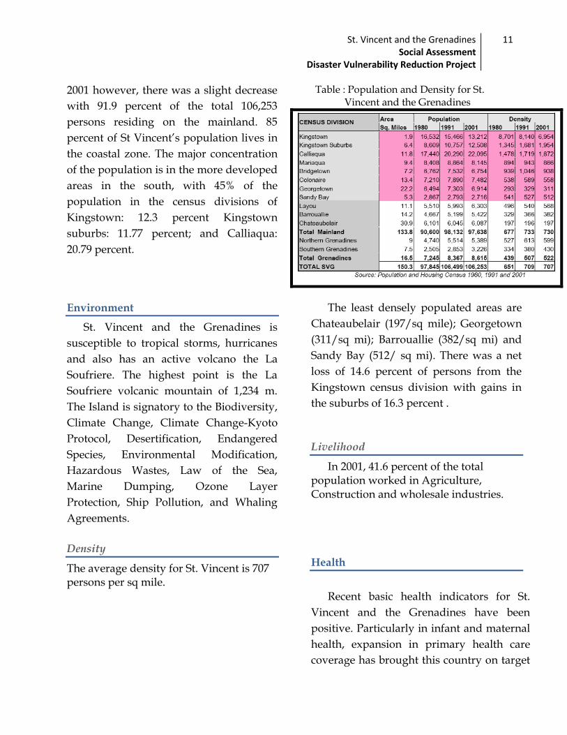
Table : Population and Density for St. Vincent and the Grenadines
The least densely populated areas are
Chateaubelair (197/sq mile); Georgetown
(311/sq mi); Barrouallie (382/sq mi) and
Sandy Bay (512/ sq mi). There was a net
loss of 14.6 percent of persons from the
Kingstown census division with gains in
the suburbs of 16.3 percent .
Livelihood
In 2001, 41.6 percent of the total population worked in Agriculture, Construction and wholesale industries.
Health
Recent basic health indicators for St.
Vincent and the Grenadines have been
positive. Particularly in infant and maternal
health, expansion in primary health care
coverage has brought this country on target

St. Vincent and the Grenadines Social Assessment
Disaster Vulnerability Reduction Project
12
to achieve Millennium Development Goal
(MDG) number four, “Reducing Child
Mortality” by 2015. There is full
immunization coverage for the under 5 age
group and maternal deaths (per 1000) are
negligible. Fertility rate is at a stable 2.8
children per woman with an average life
expectancy at birth of 74.3 years,
comparable to that of developed countries.
Through several line ministries, an
array of social assistance programmes is
implemented to address vulnerability in
the population. However, these
programmes provide less than adequate
coverage and, due to insufficient
coordination within and among them,
duplication often occurs. Weaknesses in
this area of the social sector have been
observed throughout the OECS and reflect
the need for organised social planning.
Education
The literacy level of St. Vincent and the
Grenadines is approximately 96 percent.
Universal education and free education
have helped to achieve this result. In
addition the Government provides
subsidies to further advance the provision
of private and tertiary education system.
Disaster vulnerability
St. Vincent and the Grenadines is
vulnerable to a number of natural
disasters and hazards. These include
tropical storms, hurricanes, earthquakes,
sea surges, high winds, droughts, wild
fires, landsides, soil erosion, agricultural
pest and volcanic eruptions. The La
Soufriere Volcano, located at the most
northern part of the island, last erupted in
1979. Additionally, there is an underwater
volcano in the southern part of the
Grenadines “Kick Em Jenny” that also
poses a threat, this volcano last erupted in
1977 and most recently in 2001 this
volcano is located near Union Island and
Carriacou.
The topography of the island
necessitates varying mitigation measures.
The islands capital – Kingstown - has the
highest concentration of economic activity.
The Administrative complex, which is the
administrative capital, was constructed on
reclaimed land. The Cruise ship berth, the
Port Authority, the E. T. Joshua Airport
and the island is main police station are all
in the vulnerable location. Many of the
hotels are located on the sea front. More
than sixty percent of the population lives
on the coast.
The Grenadine islands have similar
layout. Canouan, Mustique, Union Island
and Bequia they are all susceptible to
natural disasters.
The 2008 Country Poverty Assessment
(CPA) report indicated that, 30.2 percent

St. Vincent and the Grenadines Social Assessment
Disaster Vulnerability Reduction Project
13
of the population was deemed to be poor,
and 2.9 percent was deemed to be
indigent. An additional 18 percent, though
not poor were vulnerable (defined as
being at risk of falling into poverty in face
of economic shock, or other disaster) Thus
altogether 48.2 percent of the population
was under the vulnerability line.

St. Vincent and the Grenadines Social Assessment
Disaster Vulnerability Reduction Project
14
SOCIAL ASSESSMENT
CONSULTATION FRAMEWORK
An extensive consultation framework was used for the Disaster and Vulnerability
project. The development of the Social Assessment Report required the establishment of a
project Steering Committee along with the active participation of all stakeholders.
The Steering Committee has representation from the Ministry of Finance and
economic Planning, the Ministry of transport and works, the Ministry of Housing,
Ministry of Health and the Environment, Ministry of National Security- NEMO.
The social and economic committee has representation from the Ministry of social
Development , the Ministry of Finance and Economic Planning, the Ministry of Housing.
The Environment Committee has representation from the Ministry of Health and the
Environment and the Ministry of National Security – NEMO
The project implementation committee is mainly members of the PSIPMU in the
Ministry of Finance and Economic Planning.
Consultation with the community
In addition to the direct interviews and focus groups discussion it is proposed that there would be various ongoing community meetings with key members of the community as well as the entire community to provide the community members with an opportunity to give their views on the different implementation cycles of the projects.
1. Explain the project initiatives 2. Get community buy- in 3. How can specific community members or individuals be involved
Steering committee
Social and Economic Committee
Environment committee
Project implementation
committee

St. Vincent and the Grenadines Social Assessment
Disaster Vulnerability Reduction Project
15
Methodology
Overview
Participatory Research Approach (PRA): This approach is used to engage community
residents, field research facilitators, team members of the PSIPMU, as well as, other
Governmental and Non-Governmental Organizations. The PRA incorporates the
knowledge and experiences of individuals most affected by the proposed changes into
the assessment process. The field research facilitators would be trained in the use of the
participatory research methods and techniques that would be used to collect and
generate data. The PRA approach is process-oriented, bottom-up and global approach to
identify and assess the social impacts.
The fundamental principles of the methodology are a multi-disciplinary team, a mixture
of techniques, flexibility and informality. Creating opportunities for participation of the
beneficiaries is essential to accurately reflect knowledge, practices, and beliefs.
The Research Methods:
The research method used consisted of the following:
o Focus group discussions: This is a qualitative method to obtain in-depth information
on concepts and perceptions about a particular issue through small group discussion
of approximately 6–12 persons.
o Representatives were invited from the communities of Marriaqua, Buccament, Rose
hall, Rose Bank and Green Hill to discuss the component of the project that would be
implemented in their area. The questions chosen for the discussion were taken from
the Disaster Vulnerability Reduction Project Questionnaire.
Interviews were conducted with:
Individuals from the community to learn about their own situation in detail, to
discuss issues that would be difficult to address in group situations, and to reveal
their personal perspective.
Key informants, or people with specialist knowledge, to gain insights on a
particular subject, or people who can represent a particular group or viewpoint;
and
Groups, either randomly, or systematically selected to allow a focused discussion
of a particular issue

St. Vincent and the Grenadines Social Assessment
Disaster Vulnerability Reduction Project
16
Interviews were chosen for this project because it is an efficient technique use to gather
information.
Survey, a representative sample was selected by the Census office based on the
population on each census division.
Research techniques:
Both the quantitative and qualitative approaches are use to test objectively as it regards
the measurement of the social world as well as provide a more descriptive understanding
of the social conditions and livelihood of a people.
PROCESS
Stakeholder Meetings and Consultations Stakeholder meetings were conducted with the agency or agencies charged with
responsibility for executing the specific project activity. These meetings served to clarify
the activities to be completed (e.g. geographical location and work to be done), persons
identified as beneficiaries, the social benefits to individuals and communities, possible
negative outcomes and other related issues of social impact. In cases where project
activities geared towards directly benefitting community members (e.g. Emergency
communication and shelters) stakeholders were consulted to identify how issues of access
and community involvement would be stimulated.
Wider consultations were conducted with individuals (or representatives of groups) with
related expertise and community/field knowledge. These took the form of technical
committee discussions to ascertain the social impact of the project activity, the need and
acceptability of the project initiative, beneficiaries of the project and experiences of the
community with related disasters (e.g flooding).
Site Visits
Visits were made to each site with representatives from the agency or Ministry charged with the responsibility for the specific project activity. These visits preceded community consultations and attempted to clarify exact geographic location and work to be done, persons currently using the site and level of risk.
Community Participation
Community participation was sought through the use of interviews, group discussions, consultations and surveys. At each site involvement was solicited from residents and users of facilities who have been identified as beneficiaries. Community discussions will attempt to gauge the level of awareness of risk, assess acceptability of project initiative and gather perspectives of need (relative to risk). This component will generate the bulk of data for the Social Assessment.

St. Vincent and the Grenadines Social Assessment
Disaster Vulnerability Reduction Project
17
Preparation
A questionnaire was designed by the Team for the purpose of soliciting community
members’ perspectives on the proposed activities. Specifically, it aimed to address
objectives (a) to (d) of the Social Assessment:
Ensuring that project initiatives are acceptable to beneficiaries
Assessing their perspectives on the benefits and possible adverse impact of the
proposed project
Soliciting their recommendations for alternative or additional project activities
Providing baseline data on each sub-project
This instrument also served as a guide for the group discussions.
Methodology for the development of the questionnaire
1.Comments and brief project description were review from a selected committee: Chief
Statistician, Econometrician, Economist, Social Research Specialist, Project Director as
well as the social Team .
2.The World Bank’s Senior Social Assessment Specialist was consulted, basic questions
were developed, and they were used to draft the base questionnaire which took the
objectives of the social assessment as its rationale for including or excluding
questions.
3. The World Bank Senior Social Assessment Specialist commented on the questions,
suggested changes which were considered.
4. The changes were incorporated. The base questionnaire was circulated amongst a
multi-disciplinary committee for review and comments.
5. A modified questionnaire was designed to incorporate the committee’s comments.
The modified questionnaire was re-circulated amongst the committee members,
where further changes were made.
6. The final questionnaire was accepted by the committee as it was deemed to cover
relevant areas.
Questionnaire design The questionnaire was divided into seven sections as follows:
1. Demographic attributes of the respondents;
2. Community members’ experience of natural disaster; opinions towards social and
environmental issues;

St. Vincent and the Grenadines Social Assessment
Disaster Vulnerability Reduction Project
18
3. Community’s views on rivers in their community, risks, uses and possible
measures to mitigate risk
4. Community’s views on slope stability and land stability in a changing climate in
their community, threat, uses and possible measures to mitigate risk
5. Community’s views on coast in their community, danger, causes and possible
measures to mitigate risk
6. Community’s views on the Disaster Vulnerability Reduction Project, possible
impact, necessity and scope expansion.
7. Community members’ views on climate change awareness, disaster preparedness,
community participation, available skills of members, most effective Early warning
method.
Questionnaire Administration
Sixteen (16) Field Officers were trained in data collection and community risk assessment
for the purpose of the survey. This included Field Officers from the Community Division
in the Ministry of National Mobilisation etc. Field work was carried out by the sixteen (16)
field officers, along with members of the Social Assessment Team.
Data Collection:
Site Visits were made to all project sites together with representatives from the relevant
agencies, e.g. NEMO and Ministry of Transportation & Works. This was done in order to
clarify specifics of the location, nature of the work to be done, and the potential impact.
Technical Committee Meetings: Several Technical Committee Meetings were held on
separate project components to clarify issues related to project implementation and
impact. (See appendix for list persons consulted.)
Stakeholder Meeting: One (1) all-inclusive stakeholder meeting was conducted. This
meeting sought to engage representatives from all agencies charged with responsibilities
in executing and coordinating activities under the project (See appendix for list persons
consulted). The meeting was aimed at identifying:
1. Benefits of the project activities
2. Persons or category of persons who would benefit
3. Potential negative impacts including land acquisition, displacement and relocation
Two Hundred and Seventy (270) Questionnaire Interviews were conducted with residents
of 16 communities: Sandy Bay, Fancy, Georgetown, Chester Cottage, Colonarie, Spring,

St. Vincent and the Grenadines Social Assessment
Disaster Vulnerability Reduction Project
19
Marriaqua, Arnos Vale, Kingstown, Buccament, Barrouallie, Cumberland, Rose hall, Rose
bank, Dark view, and Troumaca.
Community selection was based on number of criteria including, number and scope of
activities to be conducted, population around the project site, proposed impact e.g. land
acquisition and relocation, and level of social vulnerability including poverty.
Apart from the questionnaire interviews, focus groups discussions were held with
residents of two (2) Communities: Marriaqua and Buccament. Group discussions were
also held with 1 environmental group (Kingstown) and 2 student-led groups engaged in
environmental activities (Kingstown). In addition Interviews and informal discussions
were held with key informants in Sandy Bay and Fancy.
Secondary sources were used in the collection of data for the Social Assessment. Sources
include:
2001 Population and Housing Census
2007/2008 Country Poverty Assessment
Various Damage Assessment Reports
Community Development data
Sampling and Justification
A representative sample was selected from the country’s thirteen (13) census divisions.
Census division Number Actual Response
Kingstown 46 20 17
Suburbs 35 0 No project activity
Calliaqua 77 25 24
Marriaqua 25 30 24
Bridgetown 21 20 15
Colonaire 25 20 20
Georgetown 21 40 35
Sandy Bay 7 40 37
Layou 9 25 16
Barrouallie 21 35 30
Chateaubelair 18 65 51
Northern Grenadines 21 25 Not applied
Southern Grenadines 14 25 Not applied
Total 340 365 270
The sampling method was purposive. Questionnaires were administered to persons
who, due to factors of physical or geographic location, and vulnerability to natural
St. Vincent and the Grenadines Social Assessment
Disaster Vulnerability Reduction Project
20
disaster, are most likely to benefit from the project. In practice, this included persons in
close proximity to project sites, persons living near to rivers, persons living near to the
coast, residents of communities near the coast and persons who own lands or operate
businesses in the communities of interest. Similarly, discussions and informal interviews
were held with key personnel, who, through participation in community/ environmental
organisations or previous experience with disaster, made them of interest to the
assessment.
Given the Social Assessment was aimed at assessing the potential impact of the
project, particular attention was paid to more vulnerable groups and communities for
whom impact was most critical. Special mechanisms were employed to ensure that views
of women, the poor, the elderly and other marginalized groups were adequately
represented in the sample. The methodology therefore employed the use of:
1. Oversampling as well as key informant interviews in the communities of Sandy
Bay and Fancy. These areas are of particular interest due to high levels of poverty
and the possible presence of Indigenous People. The Social Assessment Team notes
that these communities have also been subject to increased scrutiny and
participatory research, and instead employed the use of key informants to ensure
that quality data was collected. .
2. Oversampling and focus group discussions in the communities of Buccament and
Marriaqua: Due to the size of these communities, their proximity to the rivers and
the risk and incidence of flooding, it was anticipated that river defence activities
would have significant impact. Residents were therefore invited to a discussion on
the project.
3. Expert group discussions where possible: Community organisations and
environmental groups were invited to discussions where possible due to their
working knowledge of issues relevant to the project. This process also served to
establish contact with the groups, foster collaboration with ongoing activities and
identify opportunities for increasing project impact.
4. Purposive sampling in all communities to ensure the most relevant data was
collected.
Survey Sample
The survey sample comprised two-hundred and seventy (270) respondents from
sixteen (16) communities, 49.2 percent male, and 50.8 percent female. All respondents
(except 1) were over the age of 18. Thirty- two percent were over the age of 50 years and
twenty -four percent were over 55. On average persons had been a resident in their
communities for thirty and one half years.
St. Vincent and the Grenadines Social Assessment
Disaster Vulnerability Reduction Project
21
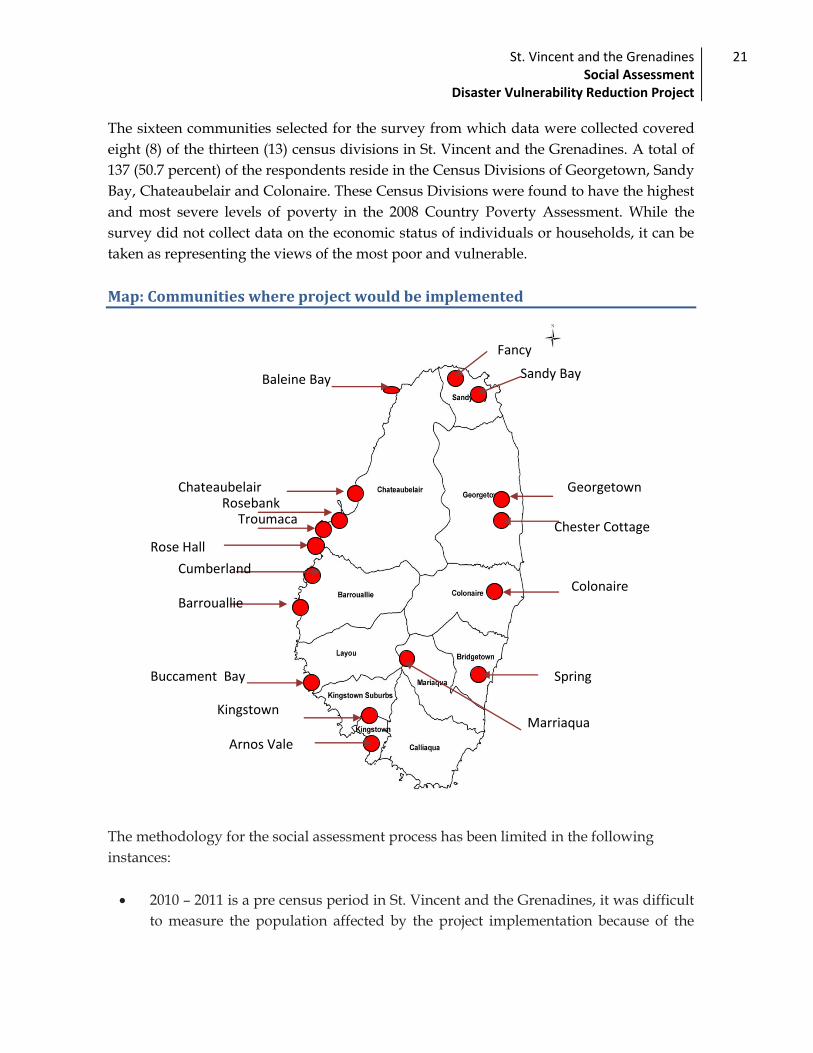
The sixteen communities selected for the survey from which data were collected covered
eight (8) of the thirteen (13) census divisions in St. Vincent and the Grenadines. A total of
137 (50.7 percent) of the respondents reside in the Census Divisions of Georgetown, Sandy
Bay, Chateaubelair and Colonaire. These Census Divisions were found to have the highest
and most severe levels of poverty in the 2008 Country Poverty Assessment. While the
survey did not collect data on the economic status of individuals or households, it can be
taken as representing the views of the most poor and vulnerable.
Map: Communities where project would be implemented
The methodology for the social assessment process has been limited in the following
instances:
2010 – 2011 is a pre census period in St. Vincent and the Grenadines, it was difficult
to measure the population affected by the project implementation because of the
Baleine Bay
Chateaubelair Rosebank
Troumaca
Cumberland
Barrouallie
Buccament Bay
Kingstown
Arnos Vale
Marriaqua
Rose Hall
Spring
Colonaire
Chester Cottage
Georgetown
Sandy Bay
Fancy

St. Vincent and the Grenadines Social Assessment
Disaster Vulnerability Reduction Project
22
incompatibility of the census division and the project profiles. Household
questionnaires could not have been implemented.
the total potential benefits of project activities on the population have not been
incorporated or investigated in some instances and would be determined in a post
social impact assessment.
There was a problem in defining the geographical extent of the project hence the
range of the population affected may not have been adequately investigated. This is
particularly relevant for the involuntary relocation of people who may reside in the
project area.
Key Social Finding
The Social Assessment revealed the need for the project activities to help to reduce the
vulnerability of the communities in the event of natural disaster.
Employment opportunities for unemployed youth, men and women on some
the project sites, for example the construction of the satellite warehouse , river
and coastal defence. In Sandy Bay some residents indicated the possible of
having the opportunity to make basketry to display next to the coastal defence.
In Colonaire, some families and farmers are currently experiencing difficulty to
get to their farms and lands are being washed away therefore they welcomed
the idea. They also suggested the construction.
Generally gender disparity is not fundamental given that the project
interventions are beneficial to all members of the community.
These finding were extracted from the questionnaire.
Table 2: Key social findings
Beneficiaries Characteristics Potential benefits
Women, Children,
Vulnerable groups
Are poor, some may
lack skills,
education/literacy ,
information, health
Direct: Temporary employment from
participation in the project activity.
Indirect: Children enjoy better standard
of living due to parents employment.
Community Members have a strong
common interest
(satellite warehouses
Direct: Organization of Self- help
groups
Improvement the livelihood of

St. Vincent and the Grenadines Social Assessment
Disaster Vulnerability Reduction Project
23
and community
centres). Members
share the responsibility
and benefits equitably.
leadership identified.
community members in the event of the
natural Disaster.
Possible skill training opportunities.
Community mobilization
Farmers , fisher folks Small producers who
contribute to the
country’s economy
Direct: farmers can have tools readily
available to clear drain and the
Infrastructural support and training
space in the use of equipment
Health department Staff and equipment
shortage, limited space
Direct: Better facilities for the entire
community to health and nutrition care

St. Vincent and the Grenadines Social Assessment
Disaster Vulnerability Reduction Project
24
COMMUNITY PROFILES
DARK VIEW
Dark View is situated in the North western section of St. Vincent. The surrounding
topography consists of steep hills that rise to heights of approximately 400ft .The
vegetation comprises a mixture of tall trees, grasses and shrubs. The general geology of
the area comprises predominantly of the Yellow Tephra Formation underlain by
volcaniclastics (Robertson 2003) This Formation is a well bedded pyroclastic fall deposit
produced by the Soufriere volcano during the late Pleistocene (Rowley 1978b). (The
pyroclastic fall deposit in this location contains mainly fine-grained ash and beds of
pumice). Volcaniclastics are believed to have been derived from the Grand Bonhomme
Volcanic Centre. Alluvial deposits are located in the area. Soil movement is a common
occurrence at Dark View mainly due to the nature of the geology where the ash beds are
fairly easily eroded and pumice beds can be washed out or individual pumice easily
removed by hand. The beach and coastal front in Dark View has suffered considerable
erosion, the sea is encroaching the land.
The Dark View main road borders the coastline. It is located approximately 50 ft away
from the mean sea level position. The elevation of the road appears to be about 12 ft above
MSL. From observation, it is evident that land seaward of the road has suffered severe
coastal erosion and that undermining of the road is imminent.
The livelihood of most community members is seine fishing it is a traditional and
current activity of residents.

St. Vincent and the Grenadines Social Assessment
Disaster Vulnerability Reduction Project
25
Arnos Vale
Activity: This component of the project includes the lining of the river via the installation 1500 x
18ft gabion baskets and reinforced concrete walls. This will be done in an effort to increase
the capacity of the river and minimise the incident and impact of flooding
Background:
In 2006 the Government of St. Vincent and the Grenadines commissioned a Drainage
Improvement Study to assess the existing drainage conditions. Among the key sites
examined was the Arnos Vale drainage system which discharges directly into the
Warrawarrow River. This area has become increasingly urbanised and the study
highlighted problems of increased runoff into the river, increased incidence of flooding
and erosion of river banks which threatens individuals’ properties. The study further
identified critical works required for flood protection and provided conceptual designs
and preliminary cost estimates for the work.
Areas in close proximity include dwellings (approximately 15), 2 business outlets, 1 utility storage house and 1 health centre.
Major beneficiaries include the residents of these dwellings and users and customers
of neighbouring facilities.
Project site

St. Vincent and the Grenadines Social Assessment
Disaster Vulnerability Reduction Project
26
Synopsis and justification: The river presents a major safety risk particularly for
dwellings along the river bank due to substantial soil erosion. In addition the river encroaches on the sewage systems of approximately two dwellings presenting various health hazards. Due to this, assessment at this site sought to engage residents in interviews in order understand current impact of the unprotected river and needs with regard to safety. These interviews created direct contact between researcher and beneficiary with a view to gaining in-depth information, soliciting cooperation during the project and enhancing the benefits to the intended beneficiary.
Colonarie
Location:
Colonaire is a small rural community located on the north eastern side of St. Vincent and
the Grenadines. It is approximately 16 miles away from the capital Kingstown. It is mainly
a farming community where persons cultivate bananas, citrus, ground provisions and
vegetables. The vegetation along the riverbed consists mainly of shrubs, coconut palms.
There is no human settlement along the river. The area is currently being affected by
Climate change patterns from torrential rains which is endangering the stabilization of the
public road.
Population
St. Vincent and the Grenadines Social Assessment
Disaster Vulnerability Reduction Project
27
According to the 2001 census the population of this area was seven thousand three
hundred and five (7,305). Five thousand and ninety nine are in the economically active
population (5,099), seven hundred and twenty nine (729), 527 males and 202 females are
unemployed.
Family structure
The extended family unit is quite evident in this community. Some households are
nuclear. Few are of single parentage, in which a woman heads the household in most
instances.
Culture
Cultural activities such as ring games and storytelling were done especially on full moon.
With the passing of the older generation and the accessibility of technology these customs
have died. The main issues affecting the community are unemployment, teen-aged
pregnancy, drug abuse, and lack of recreational activities.
Public infrastructure
The houses are constructed of concrete. Residents have easy access to utilities such as
electricity, water, telephone, cable television and internet. Residents continue to use the
river to conduct domestic chores such as washing and bathing. There is one health clinic, a
police station, a secondary school and a primary school.
General
The Colonarie river is one of the longest watercourses in St. Vincent and the
Grenadines flowing from Grande Bonhomie in the north east to the Atlantic ocean on the
central east coast. Land along the river is current used for nature conservation and
research. Some agricultural activity is also supported. This area is considered a forest
reserve in St. Vincent and there is no human settlement on the proposed site. The current
‘status’ of the river exposes surrounding the lands to erosion and threatens stability of the
public road. Due to the steep valley topography and relatively high moisture content of
the soil, there is usually rapid runoff. The vegetation along the riverbank consists mainly
of shrubs.

St. Vincent and the Grenadines Social Assessment
Disaster Vulnerability Reduction Project
28
In an effort to mitigate the effects of disaster the project proposes to include this river in
the river defence component.
Activity: The activity includes the installation of 1000 x 18ft of Gabion baskets along
the river bank.
Areas in close proximity: includes farm lands; there are no social activities or
settlements,
Major beneficiaries: owners of farm lands, road users, and members of the
surrounding community.
Synopsis and justification: The river presents medium risk to the community.
Currently there is minimum access to farm lands which results in underutilization. This work will facilitate easy access to and increase the value of nearby lands. The Members of the community will therefore be engaged in group discussion to obtain their feedback on this activity. Additionally attempts would be made to engage land owner.

St. Vincent and the Grenadines Social Assessment
Disaster Vulnerability Reduction Project
29
SANDY BAY
Location
Sandy Bay is a rural coastal village on the North Windward coast of St. Vincent and the
Grenadines in the parish of Charlotte. It lies approximately four (4) miles north of
Georgetown ( a main town in St. Vincent and the Grenadines)and south of the La
Soufriere Volcano. The community is also in close proximity to one of the island deadliest
rivers, the Rabacca Dry River. This river, which flows directly from the volcano for
regularity is DRY in nature but very powerful when flowing. It is accessible by land and
sea.
Background:
The village comprises of two (2) major sections old Sandy Bay and New Sandy Bay. The
old Sandy Bay section is believed to have existent in 1797 after the Carib wars with the
British. The area comprises mainly of decedents of the Yellow Caribs, a small number of
African slaves referred to as Black Caribs the ancestors of the Black Caribs became the
first permanent non-carib settlers in the island in 1675 mainly survivors from the sinking
Sea water has now occupied the spot
where these structure were, a church
and a house and other small shops
and old play ground

St. Vincent and the Grenadines Social Assessment
Disaster Vulnerability Reduction Project
30
Dutch ship. During the 1900s the community had numerous upsurges from heavy
flooding, hurricanes and volcanic eruption.
Population
The population according to the 2001 census, was two thousand seven hundred and
sixteen (2,716). (This is the entire Sandy Bay census division that comprises surrounding
communities. The economically active population is one thousand eight hundred and
eighty (1,880) of which 718 are economically inactive. The unemployed women in the
community are normally engaged in household chores, while the men seek odd and ends
tasks.
Livelihood
The community livelihood is embedded in subsistence and commercial farming, of crops
including cassava, peas, sorrel and sweet potatoes.
Culture
The traditional Carib culture is not practiced however, members of the community
practice the Quadrille dance. November 1 ( the day of the Dead) is also celebrated by the
cleaning and lighting of candles on their deceased relatives graves. In December, like all
other communities in St. Vincent and the Grenadines the members visits each other homes
to bring a message of glad tidings and joy.
Family Structure:
The family composition is single parents and extended families living in small to medium
size concrete and partly wooden houses. Approximately 96 percent have electricity, and
domestic water supply. Telephone in the homes is very common however a number of
people have cellular phones. Approximately 15 percent of the population use pit latrines.
Teen pregnancy seems to be the dominant social problem in this area.
Infrastructural
The institutions present in this community are one (1) health clinic, two (2) pre-
primary schools, one (1) primary and one secondary school, Churches from all religions
(Anglican, Catholic, Spiritual Baptist, Adventist, etc.) one resource centre that serves as an
office for teachers in the Secondary school, Adult Continued Education Programmes and
community meetings. Additionally the community has its´ own radio station, the
Garifuna radio, post office, police station, playing field and cemetery. Other businesses
that can be found in Sandy Bay include hairdressing, bakery, and retail shops.

St. Vincent and the Grenadines Social Assessment
Disaster Vulnerability Reduction Project
31
Sandy Bay

St. Vincent and the Grenadines Social Assessment
Disaster Vulnerability Reduction Project
32
Marriaqua
Location
The Marriaqua area is located in the southern central district in St. Vincent and the
Grenadines. The community is surrounded by rivers. The three main rivers are the Zinger;
the Tiviate and Fold river, and all meet together towards (the marriage of waters) Yambou
past river.
Composition
The community has a mixture of races mainly East Indians and Africans. It is known as
the bread basket of St. Vincent and the Grenadines for its ‘agricultural base. The lands are
very fertile as it is known to be an old volcano.
Family Structure
The family structure is single parent, nuclear and to a great extent, extended. The main
social problems according to residents in this area are unemployment, alcohol abuse,
idleness among the youth, illiteracy, immortality and HIV/AIDS.
Population
According to the 2001 Census the population was eight thousand one hundred and forty
five (8,145) which accounts for 7.2 percent of the population. There are five thousand five
hundred and forty seven (5,547) persons in the economically active age group five
hundred and fifty four (554) of whom were unemployed, 348 males and 206 females.
St. Vincent and the Grenadines Social Assessment
Disaster Vulnerability Reduction Project
33
Livelihood
While many of the persons are farmers, a great number is employed in the service sector.
Other employment activities in this area include: domestic workers; self-employed; Block-
and Baluster making and tradesmen.
Infrastructure:
There are two (2) pre-schools, one (1) primary and one (1) secondary school. There is a
health centre, post office, police station and magistrate court. There is a community centre
that was erected by the elderly in the form of self help. It houses the village council clerk’s
office, and the community development field officer’s office. There are various food shops,
retail shop, rum shops and one supermarket. Other businesses include beauty parlour,
barber shop, computer café. The community has electricity and water in about 96 percent
of the population. Access to domestic telephone.
General
The Marriaqua community is prone to heavy flooding which is often caused by prolong or
intense rainfall that result in channel overflow and human factors such as the dumping of
debris in waterways, resulting in blockage of culverts and prevention of free passage of
water, lack of river maintenance and squatting on the river banks also contributes to the
onset of rapid flooding, allowing less than two (2) hours for safe evacuation from
vulnerable areas. Many of the services in Marriaqua are located in this flood zone, the
educational facilities, the medical facility, the food distribution (food shops) and
supermarket facilities and the Police station.
Some efforts have been made to establish a warning system by the installation of simple
flood-warning devices installed at Montreal and Majorca. These devices are calibrated to
trigger an alarm at critical flood water levels and transmit this warning to designated
telephone numbers. Once this warning is received it will be conveyed to residents. The
chairperson of the Marriaqua Disaster Committee, the Co-ordinator of NEMO, the Officer-
In-Charge of the Police Station, and the medical office will all receive warning signals. The
information will then be sent to the bell person who rings the church bell to alert residents.

St. Vincent and the Grenadines Social Assessment
Disaster Vulnerability Reduction Project
34
Map provided by the field officer in the area, 2011

St. Vincent and the Grenadines Social Assessment
Disaster Vulnerability Reduction Project
35
Georgetown:
Location
Georgetown is the largest town in the north eastern side of St. Vincent and the
Grenadines. It was once a prosperous community where most persons were employed in
the sugar cane and arrowroot estates. Settlement begun in Georgetown in the late 1880s.
About 10 percent of the village is below sea level, which makes it vulnerable to flooding.
The area is vulnerable to high winds, flooding, sea surges and hurricanes. It is also one of
the closest communities to the volcano.
Livelihood
Residents make their livelihood by farming, construction sites, government and
private businesses. Most of the houses in the area are concrete brick, a few are incomplete
or are a mixture of wood and concrete. There are wooden houses that date back to 1950s
Population
The population of Georgetown according to the 2001 census was six thousand seven
hundred and sixty seven (6,767). There are four thousand six hundred and forty three
(4,643) residents, seven hundred and twenty nine (729) of whom were unemployed 459
males and 137 females.
Family structure
The family structure comprises of a majority of extended families, single parent and
nuclear families are on the increase. The main social problems identified by residents are
the unemployment and the unavailability of skilled labour

St. Vincent and the Grenadines Social Assessment
Disaster Vulnerability Reduction Project
36
BUCCAMENT
Location
Buccament is located on the south leeward side of the island and sustains the largest and
most reliable source of potable water on the island, the Dalaway catchment, which
provides over 40% of the island’s total water supply. Apart from this, the river supports
community activities such as sport fishing, bathing, and water for farms and stones for
building construction. From documentation, it was revealed that the riverbanks are
relatively shallow at 8ft to 15ft. (2001). Additionally, the river has a profound impact on
the structure and life of the communities. It empties into a flood plain of relatively poor
drained soils near Buccament Bay that runs along the main road
Activity:
The installation of gabion walls comprising staggered stocks of gabions baskets
varying in height between 12ft and 15ft. The walls will be 50ft in length on both banks
downstream of the main bridge and 1000 ft along the right bank upstream of the bridge
and 500 ft along the left bank.
Areas in close proximity: includes farm lands, properties and enterprises.
Major beneficiaries: owners of farm lands, enterprise owners, and members of the
community.
Composition
Buccament is comprised of a number of small communities starting at Buccament Bay at
the coast to Table Rock at 690 ft elevation. The Buccament economy is supported by both
St. Vincent and the Grenadines Social Assessment
Disaster Vulnerability Reduction Project
37
tourism and agricultural activities such as the newly opened Buccament Bay Beach Resort,
a five star resort which employs…Vincentians. The Vermont Valley in the centre of
Buccament is home to one of the country’s prime eco-tourism sites, the Vermont Nature
Trail and has a thriving agricultural community of over 200 registered farmers and over
400 agricultural plots, which produce a wide variety of vegetables and root crops.
Population:
Buccament is comprised of a number of small communities largely at Buccament at coast
to table rock. The Vermont valley, at the centre of Buccament is home to the country’s
prime eco-tourism sites, the Vermont nature trail.

STAKEHOLDER ISSUES
This section of the report discusses the main stakeholders consulted, the method of
consultation and the general issues raised.
Stakeholder Consultation
The purpose of the consultation was to provide an opportunity for the stakeholders to
participate in and provide input into the project as it relates to their feelings on the
activities, ideas on implementation and their reservations. Generally, the parties which
were consulted included the public/community members, government representatives,
and special interest groups. Each stakeholder group is discussed briefly below:
Key Stakeholders
Public/Community members
The communities were engaged in discussion (individually and Groups) about the
possible impacts the projects may contribute to their livelihood.
Government representatives (Ministries)
This group was comprised of representatives from several government agencies with
direct administrative and technical responsibility for specific project activities. This
included engineers from the Ministry of Transport and Works, Technical officers from the
Ministry of Housing, land and surveys, Physical Planning and Informal Human
Settlements, Ministry of Telecommunications, Ministry of Health and the Environment,
Ministry of Education, Ministry of National Security, and Ministry of National
Mobilisation. Staff from these agencies provided technical and process related inputs to
the assessment team. The consultations generally took the form of group discussions and
individual interviews.
Special Interest Groups
This group included representatives from specialist interest groups such the Red
Cross, Rainbow League and Community Disaster Management committees. This group
provided information and input relative to special community issues.
St. Vincent and the Grenadines Social Assessment
Disaster Vulnerability Reduction Project
39
Principles of the consultation and specific consultation approach
In an effort to inform and engage the stakeholders and obtain constructive feedback,
the social assessment team used a multi-tiered approach. This approach was designed to
achieve the following specific objectives:
Provide varied opportunities for stakeholders to participate in and provide input to
the project;
Ensure that key messages and concepts are conveyed in a clear, concise and
understandable manner;
Explain complex project details;
Demonstrate a transparent decision-making process.
The following techniques were used:
Presentations to groups and individuals
Focus group discussion
Individual interviews
Group discussions and meetings
Surveys
Stakeholder List Local Level - government authorities User groups – residential, commercial, institutional, medical, farmers Vulnerable Groups- residents living near project sites, Women, Children and elderly The table below summaries the types of approaches used, the particular parties
consulted and their respective responses to the critical issues presented.
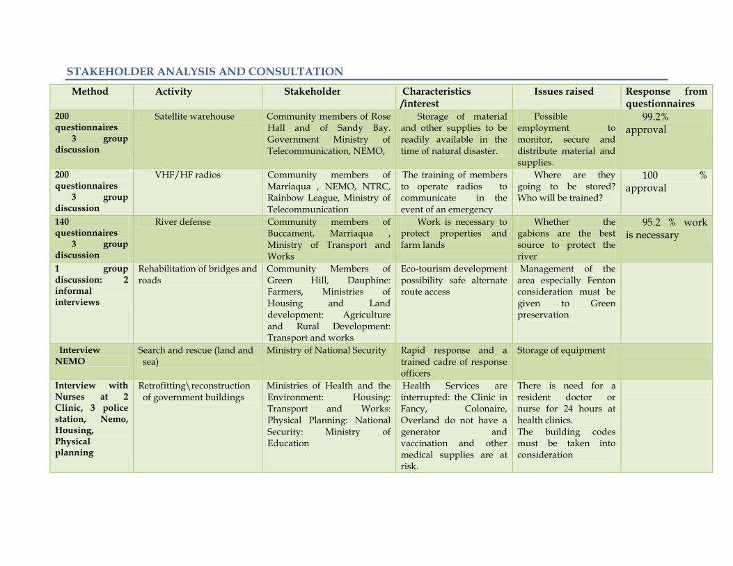
STAKEHOLDER ANALYSIS AND CONSULTATION
Method Activity Stakeholder Characteristics /interest
Issues raised Response from questionnaires
200 questionnaires
3 group discussion
Satellite warehouse Community members of Rose Hall and of Sandy Bay. Government Ministry of Telecommunication, NEMO,
Storage of material and other supplies to be readily available in the time of natural disaster.
Possible employment to monitor, secure and distribute material and supplies.
99.2% approval
200 questionnaires
3 group discussion
VHF/HF radios Community members of Marriaqua , NEMO, NTRC, Rainbow League, Ministry of Telecommunication
The training of members to operate radios to communicate in the event of an emergency
Where are they going to be stored? Who will be trained?
100 % approval
140 questionnaires
3 group discussion
River defense Community members of Buccament, Marriaqua , Ministry of Transport and Works
Work is necessary to protect properties and farm lands
Whether the gabions are the best source to protect the river
95.2 % work is necessary
1 group discussion: 2 informal interviews
Rehabilitation of bridges and roads
Community Members of Green Hill, Dauphine: Farmers, Ministries of Housing and Land development: Agriculture and Rural Development: Transport and works
Eco-tourism development possibility safe alternate route access
Management of the area especially Fenton consideration must be given to Green preservation
Interview NEMO
Search and rescue (land and sea)
Ministry of National Security Rapid response and a trained cadre of response officers
Storage of equipment
Interview with Nurses at 2 Clinic, 3 police station, Nemo, Housing, Physical planning
Retrofitting\reconstruction of government buildings
Ministries of Health and the Environment: Housing: Transport and Works: Physical Planning: National Security: Ministry of Education
Health Services are interrupted: the Clinic in Fancy, Colonaire, Overland do not have a generator and vaccination and other medical supplies are at risk.
There is need for a resident doctor or nurse for 24 hours at health clinics. The building codes must be taken into consideration

St. Vincent and the Grenadines Social Assessment
Disaster Vulnerability Reduction Project
41
Method Activity Stakeholder Characteristics /interest Issues raised Response
Interview Upgrade of disaster management agencies
NEMO Better coordination improved response
Interview Training NEMO Capacity building Facilitators
Interview Institutional strengthening Red Cross, Community based organization
Capacity building Dispersion of knowledge
Interview Site visit
Villa beach restoration Public, Ministry of Culture and Tourism, Ministry of Transport and works
Interview Site visit
Drainage Improvement MTW, community members of Arnos Vale
Interview Discussion
Relocation of the Milton Cato Memorial Hospital
Ministry of Health and Environment: Ministry of Finance and Planning Lands and surveys ; MTW:
The present building is structurally unsound Feasibility study and possible new location
Conduct a feasibility study, do design and other preconstruction
Interview Discussion
Strengthening of institutions for the enforcement of the Building codes etc
Ministry of Housing, Physical Planning , MTW
Reconstruction training monitoring; higher building standards: public awareness
Interview Public Education and Awareness
Ministry of Education ; NEMO
Public awareness Nationwide campaigns
Interviews Retrofitting of Emergency Shelters
Ministries of Education; Transport; National Security; Social Development; NEMO
Shelter management /organization. Suitable structures- repair to the roof, replacement of doors and windows.
Need for women and children to feel protected: address Water and sanitation issues separate areas for male and female
Interviews, questionnaires (270)
Slope Stabilization Communities: Ministries of Transport, Health and the Environment, Housing, NEMO
Landslides resulted in the loss of lives
Almost all communities are at risk

Land Acquisition issues
Activity Description Land Acquisition
Land acquisition involving relocation
Estimated affected population
Categories of affected persons *
Emergency Communications
Installation of nine (9)) VHF/HF radios with solar power at all the satellite warehouse facilities,
No
NA
Entire
population
NA
Drainage Improvement
Drainage improvements work in Kingstown and Arnos Vale. Some of the activities include design and civil works.
No No
~ 50 families
~ 15 business
~ 2 Farmers
Business Owners
Homeowner Others -
TBD
Relocation of the Milton Cato Memorial Hospital
Feasibility studies Design and site selection for the relocating the hospital.
TBD
TBD
TBD
TBD
Strengthening of institutions for the enforcement of the Building codes etc.
This activity involves reviewing the current building code and providing technical training to improve its enforcement
NA
NA
NA
NA
Coastal and River Defence
Protection of coastal areas and river defences including lining drainage channels and potential relocation of individual residing along vulnerable coastal location
Yes
TBD
TBD
Farmers
Fisherfolks Vulnerable
groups Others
TBD
Public Education and Awareness
Public education on hazards and reducing risks to the school population.
NA
NA
NA
NA
Roads and bridges
This activity will undertake design and construction of a bypass road.
Yes
Yes
TBD
Farmers Homeown
ers Others NTBD

St. Vincent and the Grenadines Social Assessment
Disaster Vulnerability Reduction Project
43
Activity Description Land
Acquisition Land
acquisition involving relocation
Estimated affected population
Categories of affected persons *
Retrofitting of Emergency Shelters
Emergency shelters requiring total or partial retrofit
No
No
No
No
Slope Stabilization
Landslide prone communities in which intervention measures can be implemented to reduce the landslides and reduce the impact on infrastructure.
Yes
No
TBD
TBD
Search and rescue (land and sea)
Capacitate to perform land and sea rescue operation.
NA NA NA NA
Retrofitting\reconstruction of government buildings
The upgrading of buildings such as clinics and police stations.
NO No
TBD
TBD
Upgrade of disaster management agencies
Activity included the provision of equipment and internal training
NA
NA NA NA
Training National Disaster Training Programme
N/A NA NA NA
Institutional strengthening
Involves the establishment of mechanisms for the monitoring disasters
N/A NA NA NA
Satellite Warehouse for communities
Construct and equip nine satellite warehouses for communities
No / TBD
TBD TBD TBD
Villa beach restoration
Study to determine the pollution levels and reefs.
TBD TBD TBD TBD

Analysis of Project Impacts
Overview Research has shown that disaster greatly impacts the poor, most of whom are women. It also well-recognised that all vulnerable groups including the poor, women, children, and the elderly form a part, are less able to withstand the negative impact of changes to their environment. The survey for the Social Assessment therefore, takes into account social variables of gender, age, and poverty. A large proportion of the sample (50.7 percent) is drawn from the poorest regions in St. Vincent and the Grenadines, ensuring that views of the poor are thoroughly investigated. Women and the elderly1. are also sufficiently featured in the sample, and represent 50.8 percent and 23.8 percent of the sample respectively Having sufficiently sampled these groups, the Social Assessment finds that the project objectives are acceptable and do not adversely impact any vulnerable groups. The impact of the project on the poor: Based on the analysis the project offers numerous benefits to poor communities as well as to the poor, directly.
First, in the implementation phase the civil works should provide some opportunities and
new livelihood supports temporarily. Consistent with this, residents in the communities
surveyed identified possible short-term employment creation as one major benefit of the
project.
Second, training in the sub-components of the projects for example in the operation of the
VHF/HF radios and the use of the equipment in the satellite warehouse are other
components of the project will increase the skills –set available to persons in various
communities . In particular, this will increase the capacity of poorer persons to gain
employment, and improve their competitiveness. It will also provide the necessary skills
to prepare for, mitigate and respond to disaster more effectively. Given that the poor are
vulnerable to disaster, project components which reduce risk and improve disaster
response and preparedness, also serve to reduce the vulnerability of the poor.
Third, the stabilization of land would reduce risk to farmers and residents. Processes of
soil erosion which currently results in the devaluation of land and property will be halted.
In this way farmers can maintain their level of produce given that the topsoil will be
protected. Additionally, small businesses such as grocery shops, restaurants, and bars etc,
found in the vulnerable locations near the coast will be made more secure.
One of the fundamental benefits to the poor is the mental security of knowing that they
are protected and that risks of endangerment are reduced. The poor can now concentrate
on other efforts such as increasing income for their families.
1 Elderly is commonly defined as person 55 years and over.

St. Vincent and the Grenadines Social Assessment
Disaster Vulnerability Reduction Project
45
The impact of the project on gender
The projects activities are being conducted throughout St. Vincent and the Grenadines.
The nature of the project does not connote any significant difference in the number of
females and males benefiting under the project. However, included as part of the scope of
work to retrofit of emergency shelter, is the inclusion of a provision to make shelter more
gender sensitive. The team further recommends that in retrofitting of emergency shelters
consideration should be given for:
(a) Space (Physical separation ) allocations for pregnant women
(b) Women and men should be trained in shelter management and the operation of
the VHF/HF radios, and they should be separated at night.
This includes providing separate facilities bathing and sleeping inter alia Apart from this
it is impossible to identify and mitigate all social impacts at this stage of the development
of the project. However, adequate information and community participation may reduce
any uncertainty associated with the project. Several respondents indicated that the project
may increase employment in the area; therefore consideration should be given to integrate
members (workers) from the communities. A general rule of thumb is to maximize the use
of local labour where the skill can be found.

St. Vincent and the Grenadines Social Assessment
Disaster Vulnerability Reduction Project
46
Analysis of Impact Specific Intervention
River Defence
The assessment conducted in the villages of Marriaqua, Colonarie, Arnos vale,
Buccament, and Cumberland( Spring) indicated that the river defence is necessary for the
protection of the village. In Marriaqua 76 percent of the respondent stated that the river
plays an important role in their community as it is used mainly for farming, fishing,
bathing and washing. 72 percent highlighted that the river poses a threat on their
community and 68 percent felt that the river bank was not secure. 96 percent agreed that
this activity should be undertaken in order to further secure the bank of the river.
This support was echoed in all of the villages. Residents living along the river in the
Buccament and Colonaire areas are in agreement for the project, given their agricultural
based livelihood. They support the structures because they are of the opinion that the
Gabion basket or wall would help to protect their lands as well as reduce the serious soil
erosion that results in the devaluing of their properties. One land owner in Buccament
indicated that almost 8 feet of his hand was washed away during the last five years due to
torrential rains and flooding.
In Arnos Vale, there may be biophysical changes downstream as a result of the Gabion
baskets. With the project intervention properties on the southern end of project would
now be safer as the gabions would reduce flooding in these vicinities.
Overall, respondents felt that this intervention would help accelerate economic and
social development in the community by providing a greater sense of security.
Furthermore most persons interviewed considered it very necessary as a mitigation effort,
especially in the Buccament area.
The measures that the project implement at the sites will help to strengthen the
communities flood prevention and disaster vulnerability capacities as it relates to river.
The additional positive impacts includes:
Reduction of erosion
Reduction in landslides
Protection of lives
Protection of properties
Protection of roads and other infrastructure ( Buccament and Marriaqua)

St. Vincent and the Grenadines Social Assessment
Disaster Vulnerability Reduction Project
47
There are no potential negative impacts identified by the respondents however some
concerns were raised:
First in Colonarie, the project construction along the bank of the river may prevent
farmers from rapid access to their lands. They indicated that to access the lands they
would simply cross the river when the flow is low. The implementation of the river bank
support structure implies that the height would prevent such access. They indicated that
the project should take into consideration their every day crossing to access their lands
and time they can spend cultivating their farms.
Secondly, some respondent stressed that it can create more problems for the residents
if not supervised or done properly while others felt that gabion basket are not suitable as
river defence and that there was a need for solid wall along the problematic areas.
Suggestions were also made in Buccament and Marriaqua for the gabion baskets to be
reinforced with cement, trees or mud. This suggestion was voiced by approximately 20
percent of the interviewees. A suggestion was made for the use of fascines or wattle.
Thirdly, the introduction of the gabion basket may reduce the space allotted for the
flow of the water and the banks may continue to overflow. This therefore poses an
ecological health impact, especially for vectored environmental diseases. One resident
explained “if garbage is caught in between the baskets this could create new breeding
grounds for mosquitoes and possible increase waterborne and water related infections if
the river is not cleaned regularly”. This is not a direct negative impact of the gabion
basket, but the unsanitary garbage disposal methods of the communities. Residents from
all districts indicated that there is a problem of garbage disposal in the area from the
general population and from farmers.
Coastal Defence
The Coastal defence assessment was conducted in the communities of Sandy Bay,
Georgetown and Darkview (Rosebank). The coastal front in some areas in St. Vincent and
the Grenadines is developmental land for tourism. Prime beneficiaries of these activities
consist of grocery shops operators, restaurants and bar owners and other small-business
owner. In addition to questionnaires, informal interviews were conducted with
entrepreneur living along the coast. In these communities, 95.2 percent of the respondents
indicated that this activity was necessary for the community. 92 percent felt that the
people living along the coast were unsecure and 90 percent of the respondents felt that it
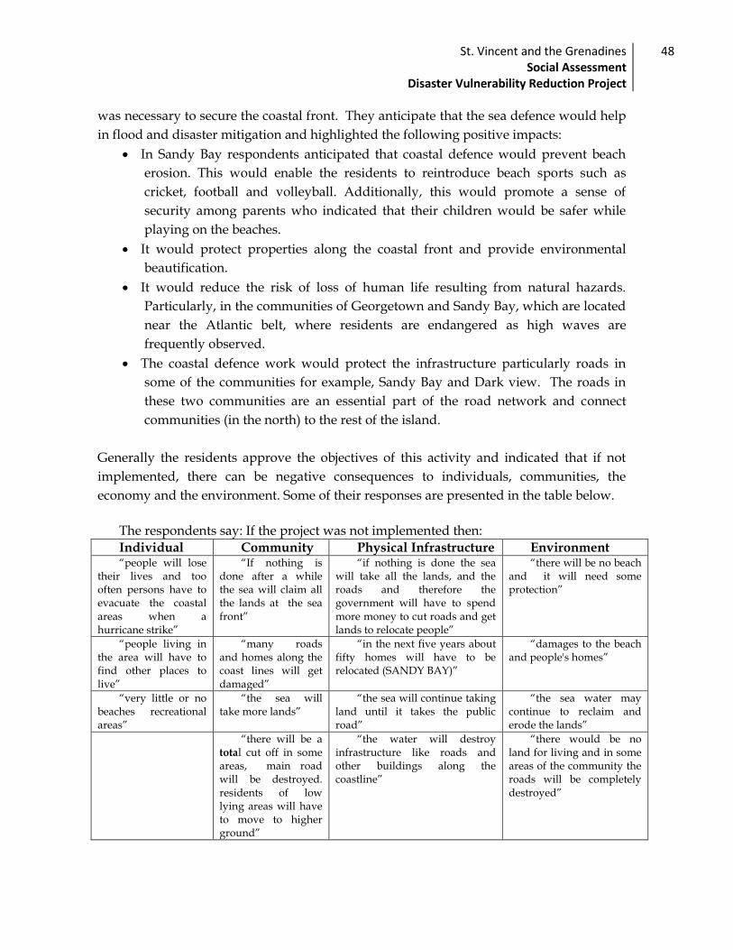
St. Vincent and the Grenadines Social Assessment
Disaster Vulnerability Reduction Project
48
was necessary to secure the coastal front. They anticipate that the sea defence would help
in flood and disaster mitigation and highlighted the following positive impacts:
In Sandy Bay respondents anticipated that coastal defence would prevent beach
erosion. This would enable the residents to reintroduce beach sports such as
cricket, football and volleyball. Additionally, this would promote a sense of
security among parents who indicated that their children would be safer while
playing on the beaches.
It would protect properties along the coastal front and provide environmental
beautification.
It would reduce the risk of loss of human life resulting from natural hazards.
Particularly, in the communities of Georgetown and Sandy Bay, which are located
near the Atlantic belt, where residents are endangered as high waves are
frequently observed.
The coastal defence work would protect the infrastructure particularly roads in
some of the communities for example, Sandy Bay and Dark view. The roads in
these two communities are an essential part of the road network and connect
communities (in the north) to the rest of the island.
Generally the residents approve the objectives of this activity and indicated that if not
implemented, there can be negative consequences to individuals, communities, the
economy and the environment. Some of their responses are presented in the table below.
The respondents say: If the project was not implemented then:
Individual Community Physical Infrastructure Environment “people will lose
their lives and too often persons have to evacuate the coastal areas when a hurricane strike”
“If nothing is done after a while the sea will claim all the lands at the sea front”
“if nothing is done the sea will take all the lands, and the roads and therefore the government will have to spend more money to cut roads and get lands to relocate people”
“there will be no beach and it will need some protection”
“people living in the area will have to find other places to live”
“many roads and homes along the coast lines will get damaged”
“in the next five years about fifty homes will have to be relocated (SANDY BAY)”
“damages to the beach and people's homes”
“very little or no beaches recreational areas”
“the sea will take more lands”
“the sea will continue taking land until it takes the public road”
“the sea water may continue to reclaim and erode the lands”
“there will be a total cut off in some areas, main road will be destroyed. residents of low lying areas will have to move to higher ground”
“the water will destroy infrastructure like roads and other buildings along the coastline”
“there would be no land for living and in some areas of the community the roads will be completely destroyed”

St. Vincent and the Grenadines Social Assessment
Disaster Vulnerability Reduction Project
49
The project has been deemed necessary for the community as it would provide a
measure of security to the poor, the elderly, women, children and the general population
in all three communities. They do not envisage any negative impact of the projects..
However some respondents in Sandy Bay expressed scepticism on the ability of coastal-
defence structures to protect the community.
Respondents stated :
“if it is not maintained [the sea defence] it would not make sense”
“it will be impossible to build a sea defence because the coastal area is a
broad area”
“it will limited beach area”
“well is if [what if] the sea come up higher”
“when water ready nobody can control it”
“How will we get access to it [the sea]”
Residents are concerned that a simple sea defence may not be sufficient to reduce their
exposure the sea entirely because of the environmental changes that have been observed
over the last 10 years.
Slope Stabilization:
Many of the lands in St. Vincent and the Grenadines are endangered and prone to landslide. The slope stabilization activities are scheduled to be conducted in Bequia, Fancy, Spring, Chester Cottage, Mount Grennan, Mt. Pleasant/Peruvian vale, Maroon Hill and Dark View. The Social Assessment finds that slope stabilisation activities are welcomed in the areas as they help to maintain the water table and fertility of the soil. In Chester cottage, Fancy, and Dark view 89.6 percent of the respondents felt that it was necessary to secure the slopes. 99.3 percent were of the opinion that the work was necessary to protect properties and control erosion.
Residents of Dark View emphasised that it was necessary to stabilize the area to
prevent hazards and prevent the communities in the north from being cut off. The implementation of the project implies that persons in Dark View must be relocated. The serious undermining of the road and mountain terrain endangers the lives and livelihood of the residents in this area. Thus, efforts should be made to prevent persons from further investing in the area.
Moreover, he slope stabilization activities may bring changes in the soil structure, that
is protection for the top soil and may impact on the availability of land for farming, soil productivity and housing.
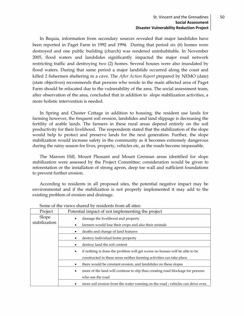
St. Vincent and the Grenadines Social Assessment
Disaster Vulnerability Reduction Project
50
In Bequia, information from secondary sources revealed that major landslides have
been reported in Paget Farm in 1992 and 1994. During that period six (6) homes were
destroyed and one public building (church) was rendered uninhabitable. In November
2005, flood waters and landslides significantly impacted the major road network
restricting traffic and destroying two (2) homes. Several houses were also inundated by
flood waters. During that same period a major landslide occurred along the coast and
killed 2 fishermen sheltering in a cave. The After Action Report prepared by NEMO (date)
(state objectives) recommends that persons who reside in the main affected area of Paget
Farm should be relocated due to the vulnerability of the area. The social assessment team,
after observation of the area, concluded that in addition to slope stabilization activities, a
more holistic intervention is needed.
In Spring and Chester Cottage in addition to housing, the resident use lands for
farming however, the frequent soil erosion, landslides and land slippage is decreasing the fertility of arable lands. The farmers in these rural areas depend entirely on the soil productivity for their livelihood. The respondents stated that the stabilization of the slope would help to protect and preserve lands for the next generation. Further, the slope stabilization would increase safety in the community as it becomes extremely dangerous during the rainy season for lives, property, vehicles etc, as the roads become impassable.
The Maroon Hill, Mount Pleasant and Mount Grennan areas identified for slope
stabilization were assessed by the Project Committee; consideration would be given to reforestation or the installation of strong apron, deep toe wall and sufficient foundations to prevent further erosion.
According to residents in all proposed sites, the potential negative impact may be
environmental and if the stabilization is not properly implemented it may add to the existing problem of erosion and drainage.
Some of the views shared by residents from all sites:
Project Potential impact of not implementing the project
Slope stabilization
damage the livelihood and property
farmers would lose their crops and also their animals
deaths and change of land features
destroy individual home property
destroy land the soil content
if nothing is done the problem will get worse no houses will be able to be
constructed in these areas neither farming activities can take place
there would be constant erosion, and landslides on these slopes
more of the land will continue to slip thus creating road blockage for persons
who use the road
more soil erosion from the water running on the road ; vehicles can drive over,

St. Vincent and the Grenadines Social Assessment
Disaster Vulnerability Reduction Project
51
loss of lives
over time the houses will collapse
over years the entire area would erode
Roads and Bridges:
This activity will include design and construction of a bypass road to Kingstown and
replace two bridges at Fenton Road. This area was assessed using secondary data sources
and a group discussion. The Fenton trail is a 6 mile stretch of mountain road which acts as
a bypass between Gomea in the West St. George constituency and Green Hill in the
Central Kingstown constituency. The road was constructed in the 1970’s and passes
through private and government-owned farm lands, forested areas and numerous
streams. The trail is an area for hiking, sight-seeing, swimming, picnicking, hunting and
increased farming. The farming created a major economic earning for the residents of
Green Hill and surrounding areas. In recent years, the road was partially destroyed and
the bridges were deemed unsuitable for use. The area also took a major setback with the
passing of hurricane Tomas and the bridges have now been declared hazardous. Farmers
in the area are at risk and access to the area that once served as an ecotourism attraction is
now closed. In an interview with, members of a community group in the area it was
disclosed that it was necessary to improve these bridges and the roads as it would yield
economical benefits for the community. Additionally the public perception of ecotourism
will increase and hereby provide some employment opportunities including the
employment of Rangers to work in the Fenton Mountain other opportunities include:
Opportunities project may provide:
Opportunity How
Tourism attraction
Eco- tourism – wild life and bird watching Water falls Hiking areas
Recreational Recreational spots Green protected area in Kingstown where persons can
relax, hunt, farm, fish and take part in other cultural activities.
Farming Farmer can produce more as they would be able to transport their produce.
Reintroduction of the green hill market
Go- green home installation
This would a house that uses solar energy. Water pumped from the river or collected in tank from
rainfall. Garbage Composting Home gardening
Employment Forest rangers, tour guide operators,

St. Vincent and the Grenadines Social Assessment
Disaster Vulnerability Reduction Project
52
The group indicated that because the area is somewhat abandoned it is increasing
becoming a dumping ground causing environmental pollution. Therefore the potential
impact for not implementing the project would include:
Contributing to the loss of forest land, resulting in habitat degradation.
Changes in the landscape and topography, which may further alter drainage
line, downstream thereby, impacting the people Greenhill.
Changing emphasis in community activity to ecotourism
Creation of a National park
There are no land acquisition issues as it pertains to the repair of the roads and bridges
in the Fenton area. The Land directly involved is owned by the Government of St. Vincent
and the Grenadines.
Other issues raised:
In Green hill – lack of value added facilities
Money is needed to develop area
Common impact for Slope stabilization, Road and Bridges, coastal defence and River defence
Potential negative impact
An increase in ambient noise levels that could annoy some residents
A change in the traffic conditions ( traffic may have to be redirected)
Water levels in the rivers

St. Vincent and the Grenadines Social Assessment
Disaster Vulnerability Reduction Project
53
Emergency Communication: Installation of VHF/HF Radios
The project activity involves the installation of emergency communication equipment
(VHF/HF radios) in 10 communities across the island. These are Bequia, Canouan,
Georgetown, Mayreau, Marriaqua, Rose Hall, Sandy Bay, and Union Island. It will include
the training of personnel in radio usage and disaster management, physical placement of
radios in community centres, satellite warehouses or other central location, and the
erection of repeaters in remote areas to boost signal transmission. This project activity
aims to improve the communication network across St. Vincent and the Grenadines, and
to enable communication during and after a disaster.
The Social Assessment identifies residents or members of the ten (10) communities as
beneficiaries of this activity. In particular beneficiaries include the poor, elderly, women
and children who, together, are more vulnerable to the adverse effects of disaster. Shelter
managers and emergency responders in each district (health clinics, police stations etc.)
will also benefit from a more comprehensive communication network.
Anecdotal evidence obtained by the Social Assessment Team indicated that several
communities (e.g. Bequia) were cut off from the main telecommunication network in
previous disasters including the most recent Hurricane Tomas due to damage
infrastructure. This evidence points to the need to provide all communities with the
facilities to communicate in a national disaster. Further a large proportion of respondents
of the survey point to ‘early’ and ‘reliable transmission of information’ as one area of concern
related to disasters. The Social Assessment therefore concludes that not only is this activity
acceptable to residents of the community (as indicated by a 99.3percent approval rating),
it is also consistent with the needs and concerns raised.
In order for stakeholders to benefit as intended, issues of training and accessibility will
need to be carefully implemented and monitored. The Social Assessment therefore
recommends that these aspects of capacity building/training and monitoring be treated
with a high level of priority.
The Social Assessment finds that this project activity will have no known adverse
impact on the quality of life, health, culture or environment of the residents of the
respective communities, either directly or indirectly. The structures to be erected
(repeaters) are of negligible size and will be placed in remote locations, integrated with
already-existing telecommunication infrastructure. No land acquisition or issues of
displacement have been identified.
St. Vincent and the Grenadines Social Assessment
Disaster Vulnerability Reduction Project
54
The project will equip communities with the resources (and training) to communicate
with the relevant authorities as well as other communities, in the event of disaster. Project
deliverables will not impose on, or disadvantage persons in anyway – it serves and
protects the interests of most vulnerable groups. Overall this project activity is likely to
build capacity in the relevant communities, and increase disaster preparedness.

St. Vincent and the Grenadines Social Assessment
Disaster Vulnerability Reduction Project
55
Satellite Warehouse
This component of the project involves the construction and outfitting of nine (9)
satellite warehouses in communities across St. Vincent and the Grenadines in an effort to
decentralise disaster management. Warehouses will be equipped with, and used to store
emergency supplies such as food and clean-up equipment to be used in the aftermath of a
disaster. Communities earmarked for Satellite Warehouses are Barrouallie (Peter’s Hope),
Bequia, Canouan, Georgetown/Colonaire, Mayreau, Mesopotamia, Rose Hall, Sandy Bay,
and Union Island.
Persons who reside in the target communities (named above) are the direct
beneficiaries of this activity. In particular, this includes residents of the poorest census
division in St. Vincent and the Grenadines (Georgetown, Sandy Bay, Colonaire,
Chateaubelair and Marriaqua). Separately, these regions have the highest numbers of poor
households and the most severe incidences of poverty, as indicated by the 2007/2008
Survey of Living Conditions. Benefits are therefore necessarily transferred to the most
vulnerable groups; this includes persons living in sub-standard housing who are often
displaced by a disaster. Communities in which disaster management personnel or groups
exist (e.g. Marriaqua) would benefit from the additional resources and training.
Communities with no formal structure for dealing with disaster will also benefit from this
initiative.
Research conducted by the Social Assessment Team indicates that the project activity
is consistent with the needs and interests of community members. Focus group
discussions in Marriaqua for example pointed towards the need for a place to ‘house’
emergency supplies and equipment and disaster management activities. Members of the
local Disaster Management Committee (DMC) present at the discussion recommended
such a facility to ensure sustainability and effectiveness of the DMCs. Separately,
respondents in the Social Assessment survey indicated that timely distribution of aid after
a disaster was an important area of concern, underscoring the need for community-based
supplies.
The possibility of land acquisition has been identified in one case only (Bequia). The
scope of impact has not yet been determined as designs are still in their preliminary phase.
It is expected that, as in every other case for which it is applicable, the Resettlement Policy
Framework and subsequent Action Plan will guide this process of land acquisition. This
framework will ensure adequate compensation and humane treatment of the persons
displaced.

St. Vincent and the Grenadines Social Assessment
Disaster Vulnerability Reduction Project
56
Save for the case of land acquisition highlighted above, no other adverse impacts have
been identified. In all instances a new facility will be designed and constructed. Feedback
from the survey indicated that community members are pleased to have additional
infrastructure in their communities. One Rose Hall resident remarked “anything to benefit
we community”. Another in Sandy Bay remarked that the proposed Satellite Warehouse
‘will help save people’s lives’ by increasing ‘access to tools and equipment’.
In sum this project activity will have limited adverse impact on residents of the target
communities and is found to be consistent with the needs.
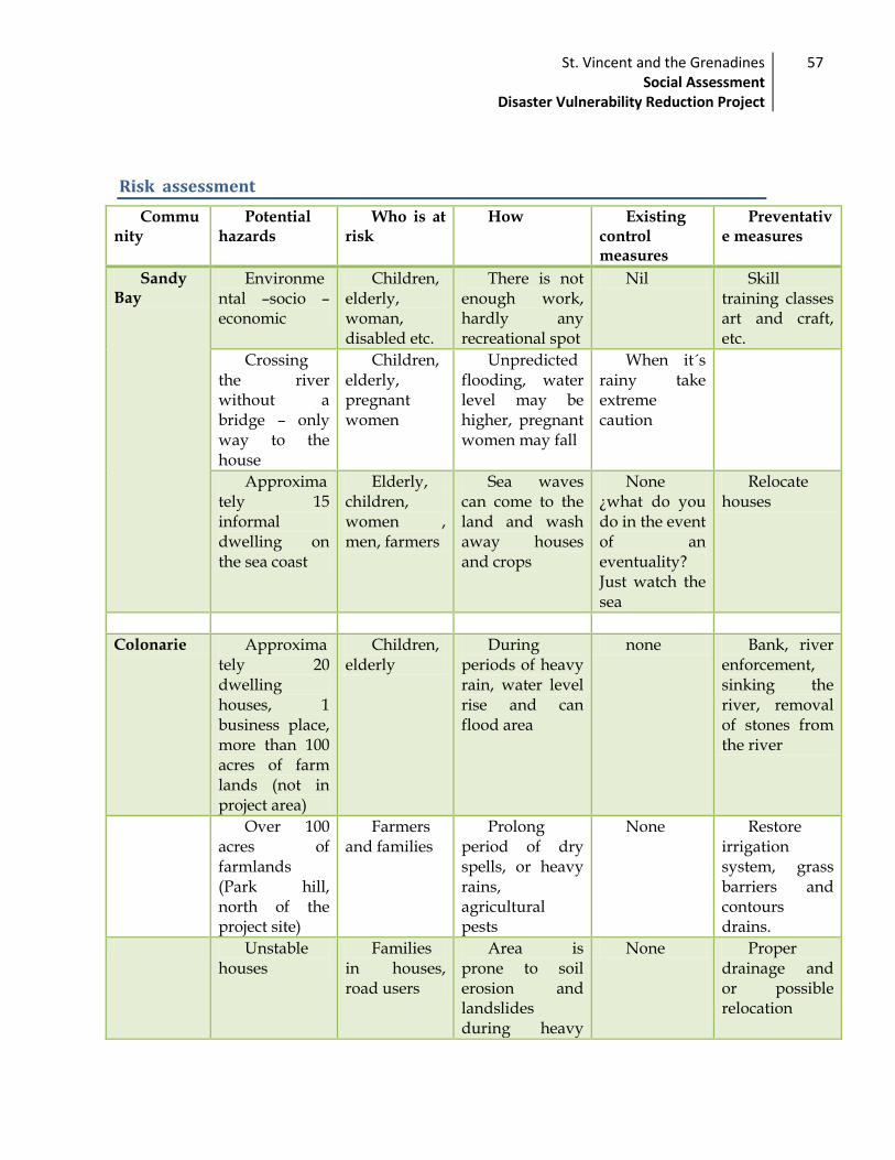
St. Vincent and the Grenadines Social Assessment
Disaster Vulnerability Reduction Project
57
Risk assessment
Community
Potential hazards
Who is at risk
How Existing control measures
Preventative measures
Sandy Bay
Environmental –socio –economic
Children, elderly, woman, disabled etc.
There is not enough work, hardly any recreational spot
Nil Skill training classes art and craft, etc.
Crossing the river without a bridge – only way to the house
Children, elderly, pregnant women
Unpredicted flooding, water level may be higher, pregnant women may fall
When it´s rainy take extreme caution
Approximately 15 informal dwelling on the sea coast
Elderly, children, women , men, farmers
Sea waves can come to the land and wash away houses and crops
None ¿what do you do in the event of an eventuality? Just watch the sea
Relocate houses
Colonarie Approximately 20 dwelling houses, 1 business place, more than 100 acres of farm lands (not in project area)
Children, elderly
During periods of heavy rain, water level rise and can flood area
none Bank, river enforcement, sinking the river, removal of stones from the river
Over 100 acres of farmlands (Park hill, north of the project site)
Farmers and families
Prolong period of dry spells, or heavy rains, agricultural pests
None Restore irrigation system, grass barriers and contours drains.
Unstable houses
Families in houses, road users
Area is prone to soil erosion and landslides during heavy
None Proper drainage and or possible relocation

St. Vincent and the Grenadines Social Assessment
Disaster Vulnerability Reduction Project
58
rain
River contamination
The entire community
During heavy rainfall, pesticides used by farmers can leach in to river
None Prevent overuse of pesticides. Contour drainage, garbage disposal cans
Crossing the river to get to farmlands without a bridge.
Farmers have to walk through river to get to lands. Some days the river is impassable
Farmers and their families
Unpredictable flooding, rising water levels during rainfalls, turbulent waters can wash away, family members, crops , farmland top soil
None Construction of a vehicular bridge.

Social Safeguard issues and other social risks
Issue Significant/Limited/No Impact
Strategy to address issue Plan or other measure included in design
Involuntary resettlement Limited. Although there is potential involuntary resettlement issues in some activities, the project is designed to minimise land acquisition and resettlement impacts. The extent of these will be further defined as the project develops.
A project level Resettlement Policy Framework (RPF) has bee drafted and activity level RPFs will be prepared as necessary.
Resettlement Policy Framework
Indigenous Peoples No impact. The indigenous peoples are fully integrated into mainstream society. However, the impacts were investigated as part of the due diligence and it was found that the project is unlikely to affect this group.
Due diligence No action required
Labour Employment opportunities
Construction operation is likely to generate considerable employment at both the local and national level
No action required
Other risk and vulnerability
No impact. No significant risks or vulnerability have been identified
No action required

St. Vincent and the Grenadines Social Assessment
Disaster Vulnerability Reduction Project
60
World Bank Safeguard Policies
World Bank Safeguard Policies and their implications
Policy Relevance to the project Implications
Remarks
Environmental Assessment (BP/OP 4.01)
The following activities retrofitting of emergency shelter; VHF/HF radios with solar power; slope stabilization; coastal and river defence; rehabilitation of roads and bridges and the satellite warehouses will be undertaken. These have been affected by natural hazards and may have caused soil erosion. The activities would cause minor damage to nature and would contribute to the improvement of the vulnerability levels of the communities additionally would help to improve farm productivity.
Triggered Activities proposed would help improve environmental conditions. However, an environmental assessment has been carried out where a mitigation plan would guide the way to contain any adverse impact of project activities.
Indigenous Peoples (BP/O.D. 4.20)
There are people of indigenous descent living in some project sites however these people do not have a separate culture or livelihood to the other habitat of St. Vincent and the Grenadines
Not triggered
Social assessment highlights that no project activities are going to adversely change the quality of life of any indigenous people or any individual in area where project activities are being developed
No actions required.
Involuntary resettlement(BP/O.P 4.12)
There may be some land acquisition issues in Specific Subproject coastal defence and slope stabilizations
Triggered The social assessments necessitates a clear geographical path of all constructions be outlined so as to determined with certainty the exact locations and persons who may be affected. However, the Ministry of Housing under the Land Acquisition would handle all implications and make recommendations for suitable relocation where necessary.

St. Vincent and the Grenadines Social Assessment
Disaster Vulnerability Reduction Project
61
Beneficiaries table*
Community Issues to be address
BENEFICIARIES
Social Safeguard
WHO Total GENDER ( 2001)
How
Vulnerable group
consultation
M
ALE FE
MALE
Grenadines
Union Island
VHF/HF radios with solar power 3354
1765
1589 yes Environmen
tal Assessment (OP/BP 4.01)
Satellite warehouse
Mayreau
poor 254 1
37 117 yes
Environmental Assessment (OP/BP 4.01)
Satellite warehouse
marginalized
community
Canouan
VHF/HF radios with solarpower 1165
665 500 yes Environmen
tal Assessment (OP/BP 4.01)
Satellite warehouse
Bequia
VHF/HF radios with solarpower 4861
2511
2350 yes
Involuntary Resettlement (OP/BP 4.12) Environmental
Satellite warehouse
Teenage mothers

St. Vincent and the Grenadines Social Assessment
Disaster Vulnerability Reduction Project
62
Retrofitting of
Emergency Centre Assessment (Op/BP 4.01
Slope Stabilization Paget farm poor
rehabilitation of road Paget farm
Community Issues to be address BENEFICIARIES
Social
Safeguard
WHO Total GENDER ( 2001)
How
Vulnerable group consultation
MA
LE FE
MALE
Retrofitting /reconstruction health
clinic marginalized
Sandy Bay VHF/HF radios indigent 1425 769 656 yes
Satellite warehouse Elderly
coastal / river
defence Teenage
mothers
Overland
Retrofitting /reconstruction health
clinic poor 549 284 265 yes
Environmental Assessment (OP/BP 4.01) Indigenous
peoples (O.D. 4.20)
Public awareness
Education
Georgetown VHF/HF radios poor 5676 2888 2788 yes
Satellite warehouse Environmental Assessment
Coastal/River
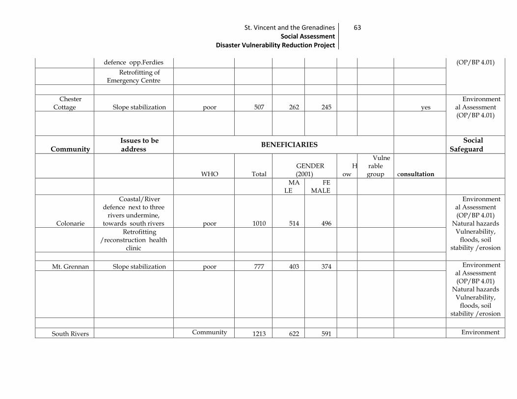
St. Vincent and the Grenadines Social Assessment
Disaster Vulnerability Reduction Project
63
defence opp.Ferdies (OP/BP 4.01)
Retrofitting of
Emergency Centre
Chester Cottage Slope stabilization poor 507 262 245 yes
Environmental Assessment (OP/BP 4.01)
Community Issues to be address
BENEFICIARIES
Social Safeguard
WHO Total GENDER (2001)
How
Vulnerable group consultation
MA
LE FE
MALE
Colonarie
Coastal/River defence next to three
rivers undermine, towards south rivers poor 1010 514 496
Environmental Assessment (OP/BP 4.01)
Natural hazards Vulnerability,
floods, soil stability /erosion
Retrofitting /reconstruction health
clinic
Mt. Grennan Slope stabilization poor 777 403 374 Environmental Assessment (OP/BP 4.01)
Natural hazards Vulnerability,
floods, soil stability /erosion
South Rivers Community 1213 622 591 Environment

St. Vincent and the Grenadines Social Assessment
Disaster Vulnerability Reduction Project
64
Retrofitting /reconstruction health
clinic
elderly poor
al Assessment (OP/BP 4.01)
Environmental Assessment (OP/BP 4.01)
Natural hazards Vulnerability,
floods, soil stability /erosion
Spring Slope stabilization elderly, unemployed
701 353 348
Community Issues to be address BENEFICIARIES
WHO Total
GENDER (2001)
How
Vulnerable group consultation
Social Safeguard
MA
LE FE
MALE
Windward
Mt. Pleasant /Peruvian vale Slope stabilization farmers 1261 624 637
Environmental Assessment (OP/BP 4.01)
Natural hazards Vulnerability,
floods, soil stability /erosion
elderly
Stubbs 6288 309
6 319
2
Environmental Assessment (OP/BP 4.01)
Retrofitting /reconstruction
Police station Police

St. Vincent and the Grenadines Social Assessment
Disaster Vulnerability Reduction Project
65
Maroon Hill Slope stabilization Farmers Environmental Assessment (OP/BP 4.01)
Natural hazards Vulnerability,
floods, soil stability /erosion
Community Issues to be address
BENEFICIARIES
Social Safeguard
WHO Total GENDER ( 2001)
How
Vulnerable group
consultation
MALE FE
MALE
Marriaqua VHF/HF radios
with solarpower poor, teenage
mothers, children, farmers, elderly, disabled, nurses,
police, community, unemployed
3103 1569 1534
Environmental Assessment (OP/BP 4.01)
Natural hazards Vulnerability,
floods, soil stability /erosion
Public awareness
Education
Satellite warehouse
Retrofitting /reconstruction Police
station
Retrofitting /reconstruction health
clinic
River defence
(Tiviot river)

St. Vincent and the Grenadines Social Assessment
Disaster Vulnerability Reduction Project
66
Central
Calliaqua high poverty
index , teenage mothers, children, elderly, disabled,
police, community, unemployed
6946 3396 3550
Environmental Assessment (OP/BP 4.01)
Retrofitting /reconstruction Police
station
Villa
EnvironmentaL Assessment (OP/BP 4.01)
Villa beach
restoration
Community Issues to be address
BENEFICIARIES
Social Safeguard
WHO Total GENDER ( 2001) How
Vulnerable group consultation
MALE
FEMALE
Arnos vale
poor, children, elderly,
community, unemployed
4668 229
5 237
3 Environmen
tal Assessment (OP/BP 4.01)
Natural hazards Vulnerability,
floods,soil stability /erosion
Drainage
improvement
river defence
South River Coastal defence Environmen

St. Vincent and the Grenadines Social Assessment
Disaster Vulnerability Reduction Project
67
road taL Assessment
(OP/BP 4.01)
Kingstown
Relocation of the Milton Cato Memorial
Hospital
urban poor, teenage mothers, children, elderly,
disabled, police, community, unemployed
Environmental Assessment (OP/BP 4.01)
Natural hazards Vulnerability,
floods, soil stability /erosion
Retrofitting of Kingstown
Government
Fenton Rehabilitation of
roads and bridges surrounding community
Green Hill,
Environmental Assessment (OP/BP 4.01)
Dorsetshire Hill
Retrofitting of Emergency Shelter
community members
1064 538 526
Environmental Assessment (OP/BP 4.01)
Community Issues to be address BENEFICIARIES
Social Safeguard
WHO Total GENDER ( 2001)
How
Vulnerable group consultation
MALE
FEMALE
Leeward
Campden Park
Retrofitting of emergency centre- Community centre
poor, children, elderly,
community,
2914 149
6 141
8 Environmen
tal Assessment (OP/BP 4.01)

St. Vincent and the Grenadines Social Assessment
Disaster Vulnerability Reduction Project
68
unemployed
Buccament River defence high poverty index , teenage
mothers, children, elderly,
disabled, community, unemployed
1460 723 737 Environmental Assessment (OP/BP 4.01)
Natural hazards Vulnerability,
floods, soil stability
/erosion: Water quality
and water resource
availability and use
Peter's hope
785 401 384
EnvironmentaL Assessment
(OP/BP 4.01)
Satellite
warehouse
Community Issues to be address POPULATION
Social Safeguard
WHO Total GENDER ( 2001)
How
Vulnerable group
consultation
MALE
FEMALE
Barrouallie VHF/HF radios
with solarpower high poverty
index , teenage 2558 132
2 123
6 Environmen
taL Assessment
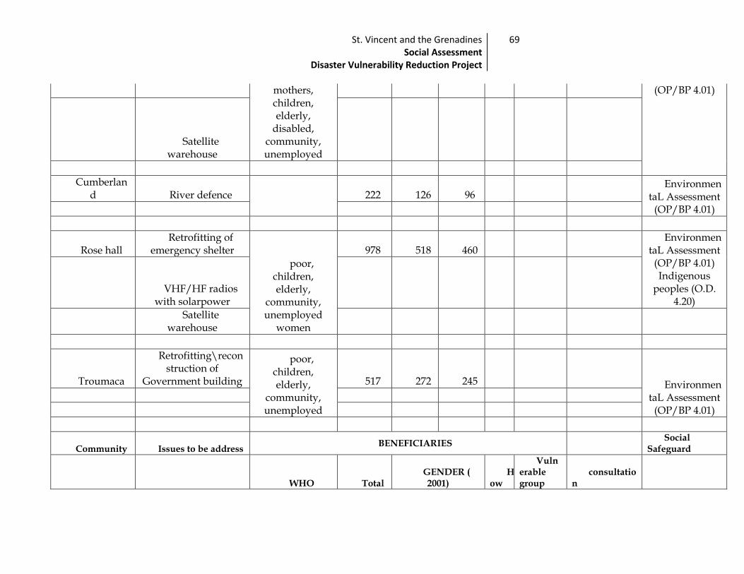
St. Vincent and the Grenadines Social Assessment
Disaster Vulnerability Reduction Project
69
mothers, children, elderly,
disabled, community, unemployed
(OP/BP 4.01)
Satellite
warehouse
Cumberland River defence
222 126 96 Environmen
taL Assessment (OP/BP 4.01)
Rose hall Retrofitting of
emergency shelter
poor, children, elderly,
community, unemployed
women
978 518 460 Environmen
taL Assessment (OP/BP 4.01) Indigenous
peoples (O.D. 4.20)
VHF/HF radios with solarpower
Satellite
warehouse
Troumaca
Retrofitting\reconstruction of
Government building
poor, children, elderly,
community, unemployed
517 272 245 EnvironmentaL Assessment
(OP/BP 4.01)
Community Issues to be address BENEFICIARIES
Social Safeguard
WHO Total GENDER ( 2001)
How
Vulnerable group
consultation
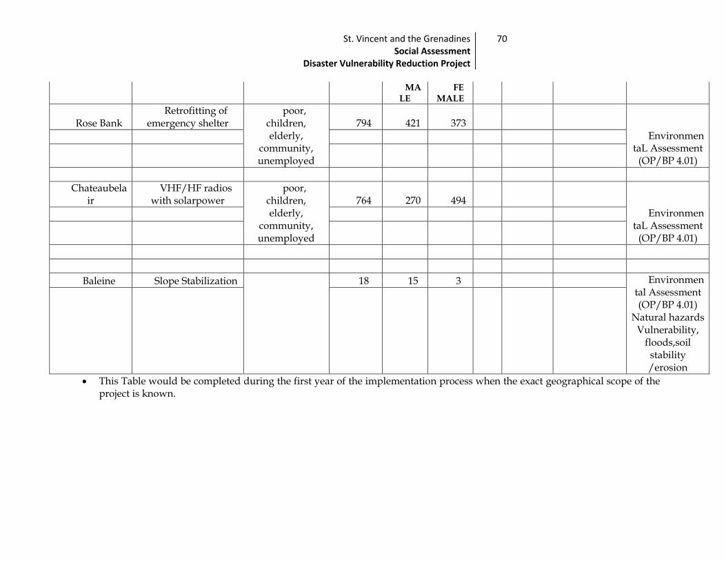
St. Vincent and the Grenadines Social Assessment
Disaster Vulnerability Reduction Project
70
MA
LE FE
MALE
Rose Bank Retrofitting of
emergency shelter poor,
children, elderly,
community, unemployed
794 421 373 Environmen
taL Assessment (OP/BP 4.01)
Chateaubelair
VHF/HF radios with solarpower
poor, children, elderly,
community, unemployed
764 270 494 Environmen
taL Assessment (OP/BP 4.01)
Baleine Slope Stabilization
18 15 3 Environmental Assessment (OP/BP 4.01)
Natural hazards Vulnerability,
floods,soil stability /erosion
This Table would be completed during the first year of the implementation process when the exact geographical scope of the project is known.

Recommendations
To respond to the situation that may arise during the implementation of this
project the focus would be on the community development aspects.
Community development is the process to strengthen the participation and
organization of the population in search of answers to improve their own locality,
under the principles of cooperate, mutual aid and community.
Recommendation to address social issues:
Access to facilities:
The implementation of new structures requires the dissemination of
information as it regards accessibility and operation to potential
beneficiaries. Awareness campaigns and other educational activities should
be conducted at all projects implementation sites.
The formation of Community Self help groups is recommended for the
sustainability of the project management.
Traffic
Safeguard be built into the implementation in order to minimize impact which
include scheduling works at best time to minimize disruptions. Where disruptions
cannot be avoided develop a traffic plan outlining alternative routes and
appropriate signage.
Financing:
Social protection activities and their funding levels should be taken into
consideration.
Additional funding would be require for social protection programmes
NOISE Pollution
Noise Control: In the execution of works, particularly in residential
communities, the contractor shall control noise emissions generated as a
result of contracting activities to the extent possible. In the case of site
locations where noise disturbance will be a concern, the contractor shall

St. Vincent and the Grenadines Social Assessment
Disaster Vulnerability Reduction Project
72
ensure that the equipment is in good working order with manufacturer
supplied noise suppression (mufflers etc.) systems functioning and in good
repair. Where noise management is a concern, the contractor shall make
reasonable efforts to schedule activities during normal working hours
(between 8 am and 5 pm). Where noise is likely to pose a risk to the
surrounding community, the contractor shall inform the site manager and
shall develop a public notification and noise management plan for approval
by the Central Planning Division.
Inform communities when heavy equipment usage would be taking place
and during what hours.
Organize scenic tours to take members if noise prolongs beyond 2 hours
For the areas with Emergency shelter, Satellite warehouse ,
Forming Self Help Groups (SHGs) in all project areas of Saint
Vincent and the Grenadines.
Co-ordinate actions with the populace of the area and the authorities
so that there is institutional support.
Use of the community members with leadership skills (observed and
identified by community members) in the areas of health, education,
etc.
Facilitate training to the SHGs through a workshop.
Establish a system of communication and information in the
communities.
Support programmes which build the capacity of the local
authorities and other institutions which can support community
members in Shelter management.
Train various members in the use of VHF radios
For the schools that would be emergency centres: Disruption to school
The project includes rehabilitative works to schools. In some cases,
construction may occur while classes are being held. If this is the case, the
school will used undamaged areas for classroom activities. The contractor
shall seek to minimize as much as possible, the impacts to ongoing classes.
Contractors shall also work with the Ministry of Education’s designate to
manage the storage and flow of materials so as to minimize disruption to
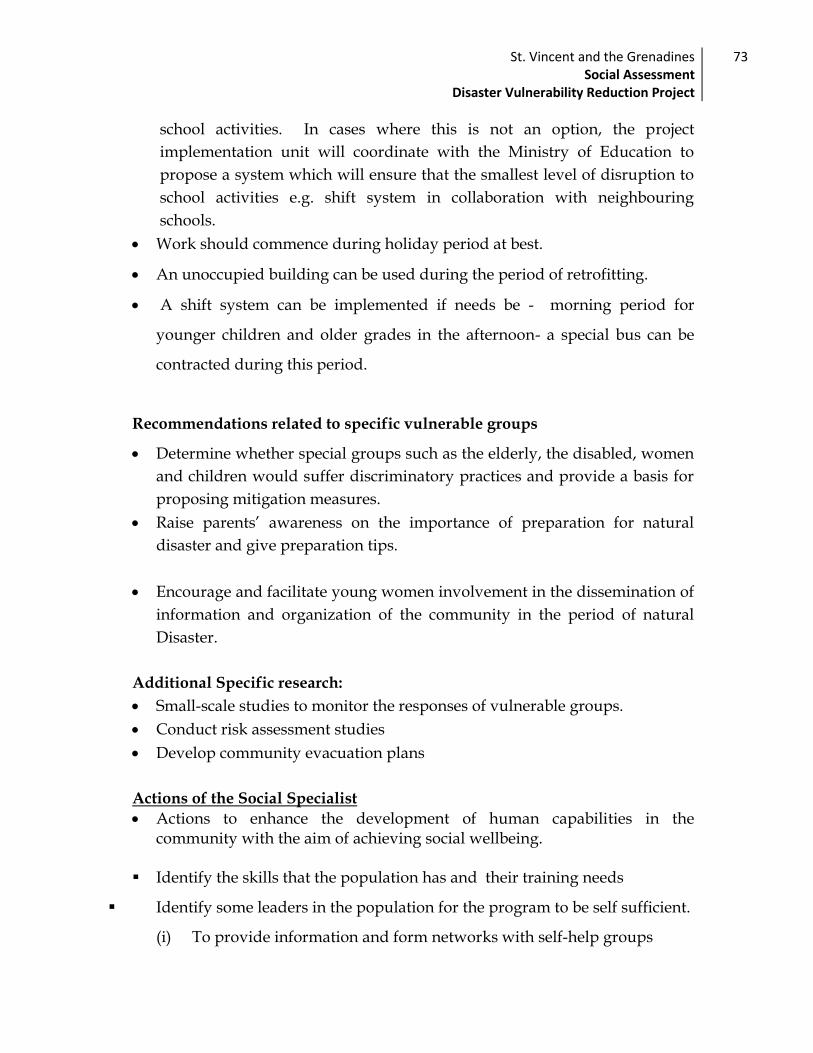
St. Vincent and the Grenadines Social Assessment
Disaster Vulnerability Reduction Project
73
school activities. In cases where this is not an option, the project
implementation unit will coordinate with the Ministry of Education to
propose a system which will ensure that the smallest level of disruption to
school activities e.g. shift system in collaboration with neighbouring
schools.
Work should commence during holiday period at best.
An unoccupied building can be used during the period of retrofitting.
A shift system can be implemented if needs be - morning period for
younger children and older grades in the afternoon- a special bus can be
contracted during this period.
Recommendations related to specific vulnerable groups
Determine whether special groups such as the elderly, the disabled, women
and children would suffer discriminatory practices and provide a basis for
proposing mitigation measures.
Raise parents’ awareness on the importance of preparation for natural
disaster and give preparation tips.
Encourage and facilitate young women involvement in the dissemination of
information and organization of the community in the period of natural
Disaster.
Additional Specific research:
Small-scale studies to monitor the responses of vulnerable groups.
Conduct risk assessment studies
Develop community evacuation plans
Actions of the Social Specialist
Actions to enhance the development of human capabilities in the community with the aim of achieving social wellbeing.
Identify the skills that the population has and their training needs
Identify some leaders in the population for the program to be self sufficient.
(i) To provide information and form networks with self-help groups

St. Vincent and the Grenadines Social Assessment
Disaster Vulnerability Reduction Project
74
(ii) Provide consultation, advice and logistical support
(iii) To promote community education
(iv) Investigate the social problems of the community
(v) Review and agree upon the working procedures to be followed. i.e. in
cases of resettlement ensure that the World Bank Operational
procedures are followed.
(vi) Undertake a systematic intervention.
(vii) Organize the effort to identify all active elements of the intervention,
with special attention to the unique contribution of social support to
the desired end result.
(viii) Take precautions to observe side effects (immediate or delayed)
insofar as it affects the source of support and beneficiaries.
Promote the organization of the institution. Translating public education
campaigns (e.g., promotion of informal sources of support and mutual aid
groups).
Guide and assist the poor in setting up plans to rebuild their social life if
affected by project implementation.
Strengthen the efforts which enhance gender participation for all age
groups, and raise awareness and contribution of all community members in
disaster management preparation.
Conduct risk assessment studies
Develop community evacuation plans.
General recommendations:
Policy:
A comprehensive policy on social protection is required. When required
the Bank policy would govern
St. Vincent and the Grenadines Social Assessment
Disaster Vulnerability Reduction Project
75
Creation of a documentation of the entire project implementation to serve as
a guide to follow in cases of relocation.
Utilization of the Sustainable livelihood approach provides a useful guide
or checklist for identifying and assessing social impacts.
Targeting:
Develop community specific responses.
Allow community to define the response.
Each community where the project would be implemented signifies
different personalities therefore it is important to recognise that addressing
cultural and attitudinal factors requires more effort and continuous
intervention additionally, the vulnerability of children may require a broad
approach.
Implementation:
The Social specialist must guard against creating unrealistic expectations,
and be sure that the community understand the aim of the project and are
familiar with its components;
The Social Specialist will need to explore all the relevant dimensions of the
social environment, not only those that are obvious and easily accessible;
During implementation it will be important to consciously seek out the
views of marginalized and vulnerable individuals and social groups. To
access their perspectives requires conscious effort and strategizing and may
mean that intervention has to be done on an individual level.
A schedule of the exact project components will be needed in advance for the
determination of relocation and resettlement so that the procedures can be
followed to allow a smooth transition of the affect persons.

Monitoring and Evaluation Plan
Project Sector Investment Programme Management Unit (PSIPMU) in the
Central Planning Division will manage the monitoring of the social impact of
the project. This team will consist of a social specialist enlisted for the life of the
project for the purposes of monitoring project impact, and staff of the PSIPMU.
The PSIPMU is staffed with professionals trained in the area of monitoring and
evaluation, (including in data collection and evaluation methods) who are
experienced with World Bank projects. The World Bank team will assist the
PSIPMU in monitoring by the performance indicators outlined below.
Institutional arrangements
Project impact will be monitored using a three-tiered monitoring and
evaluation system. This will comprise the Project Monitoring Team at one level,
key personnel within the Implementing agencies/line ministries, and field
staff. The team will also engage the World Bank for input between reporting
and during Bank missions.
Project Monitoring Team
Ministry of Health, Wellness and
the Environment
Ministry of Education
Ministry of Land Housing and Surveys
Ministry of Transport and Works
Field Staff of the various agencies; community workers

St. Vincent and the Grenadines Social Assessment
Disaster Vulnerability Reduction Project
77
Monitoring procedure
The monitoring team will report to the World Bank quarterly as part of the
agreed project reporting on performance indicators outlined below. Updates
will also be provided to the Bank semi annually in the context of the Bank’s
supervision missions. These will include generally beneficiary analyses and
treatment of persons affected by the project.
The monitoring team will ensure that the management of the project takes
social safeguards into account, at all levels, and that facilities are enacted to
mitigate social impacts highlighted by this assessment. It will monitor the
schedule of physical works and progress, use of social safeguards and World
Bank Operational Policy, and adherence to stated Resettlement Policy
Framework where required. To do this the team will gather information from
Project Steering Committee, implementing agencies, and field workers, on a
regular basis as demanded by the progress of the project. It will consult with
members from the relevant government ministries such as the Legal Affairs
department in monitoring the legal framework of resettlement and the Ministry
of Housing, land and Surveys for issues relating to land acquisition and
relocation .
The monitoring team will also collect data from field workers of the various
line ministries in all communities relevant to the project, including staff of the
Community Development Department and the Ministry of National
Mobilisation. This will be done in order to more directly monitor impact at the
community level and mitigate against unforeseen negative impact during the
course of the project.
Community involvement
Implement activity
Document evidence
Educate community
Monitoring and
evaluation
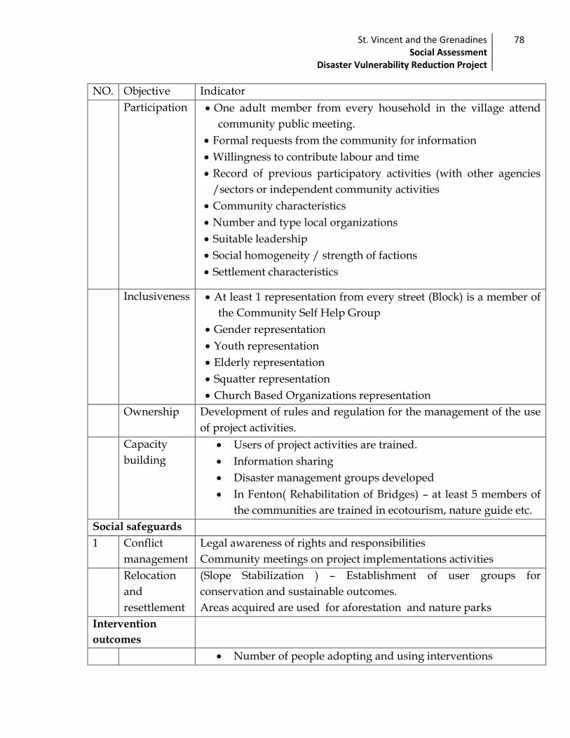
St. Vincent and the Grenadines Social Assessment
Disaster Vulnerability Reduction Project
78
NO. Objective Indicator
Participation One adult member from every household in the village attend
community public meeting.
Formal requests from the community for information
Willingness to contribute labour and time
Record of previous participatory activities (with other agencies
/sectors or independent community activities
Community characteristics
Number and type local organizations
Suitable leadership
Social homogeneity / strength of factions
Settlement characteristics
Inclusiveness At least 1 representation from every street (Block) is a member of
the Community Self Help Group
Gender representation
Youth representation
Elderly representation
Squatter representation
Church Based Organizations representation
Ownership Development of rules and regulation for the management of the use
of project activities.
Capacity
building
Users of project activities are trained.
Information sharing
Disaster management groups developed
In Fenton( Rehabilitation of Bridges) – at least 5 members of
the communities are trained in ecotourism, nature guide etc.
Social safeguards
1 Conflict
management
Legal awareness of rights and responsibilities
Community meetings on project implementations activities
Relocation
and
resettlement
(Slope Stabilization ) – Establishment of user groups for
conservation and sustainable outcomes.
Areas acquired are used for aforestation and nature parks
Intervention
outcomes
Number of people adopting and using interventions

St. Vincent and the Grenadines Social Assessment
Disaster Vulnerability Reduction Project
79
Number of problems arising from misuse of facilities
Number of persons attending training meeting
User satisfaction measured
Number with satisfactory knowledge to use new equipment
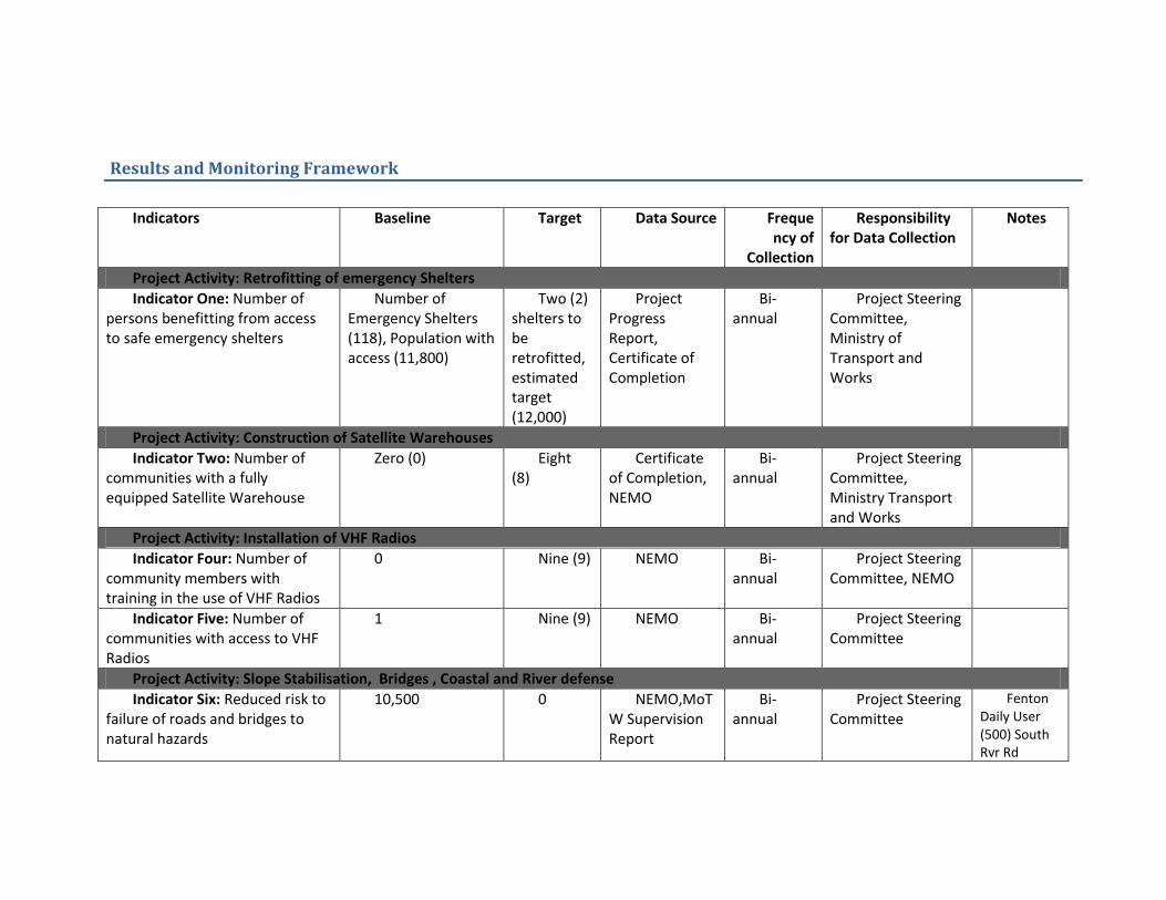
Results and Monitoring Framework
Indicators Baseline Target Data Source Frequency of
Collection
Responsibility for Data Collection
Notes
Project Activity: Retrofitting of emergency Shelters
Indicator One: Number of persons benefitting from access to safe emergency shelters
Number of Emergency Shelters (118), Population with access (11,800)
Two (2) shelters to be retrofitted, estimated target (12,000)
Project Progress Report, Certificate of Completion
Bi-annual
Project Steering Committee, Ministry of Transport and Works
Project Activity: Construction of Satellite Warehouses
Indicator Two: Number of communities with a fully equipped Satellite Warehouse
Zero (0) Eight (8)
Certificate of Completion, NEMO
Bi-annual
Project Steering Committee, Ministry Transport and Works
Project Activity: Installation of VHF Radios
Indicator Four: Number of community members with training in the use of VHF Radios
0 Nine (9) NEMO Bi-annual
Project Steering Committee, NEMO
Indicator Five: Number of communities with access to VHF Radios
1 Nine (9) NEMO Bi-annual
Project Steering Committee
Project Activity: Slope Stabilisation, Bridges , Coastal and River defense
Indicator Six: Reduced risk to failure of roads and bridges to natural hazards
10,500 0 NEMO,MoTW Supervision Report
Bi-annual
Project Steering Committee
Fenton Daily User (500) South Rvr Rd

St. Vincent and the Grenadines Social Assessment
Disaster Vulnerability Reduction Project
81
(10,000)
Indicator Seven: Reduced risk of community population to flooding in areas with flood mitigation works financed by the project
60 0 NEMO Annual Project Assessment and Report, MoTW Supervision Report
15 HH, approx 4 persons each
Indicator Eight: Number of persons relocated from unsafe locations (exposure to flooding, erosion etc.)
0 30 Ministry of Housing, Land and Surveys
Annual Social Team,
Project Activity Education and Awareness
Indicator Nine: Number of Community Disaster Management Groups functioning
Eight (8) 30 NEMO Bi-annual
NEMO and Project Steering Committee
*Group meetings
Indicator Ten: Number of persons participating in disaster management workshops
0 108 NEMO, Ministry of Education
Bi-annual
NEMO and Project Steering Committee

Community Participation Plan
A steering committee whose members are created from the PSIPMU responsible for
guiding the preparation and broad policy direction on the future development as they serve
as an informational resource tot project development.
In an effort to deliver maximum benefit to stakeholders and ensure that project
outcomes do not adversely affect the intended beneficiaries, the Social Assessment Team
recommends the communities, both geographical and that as defined by interests, be
included in the following activities during the life of the project:
Educational and Awareness Programmes on disaster risk management and climate
change issues and project activities. This will be done at the school level and will be
incorporated into National Emergency Management Organization (NEMO’s) existing
plans. NEMO, Ministry of Education and Project Monitoring Committee will take
responsibility for this activity.
Training in the use of facilities. Key personnel identified during the social
assessment will be trained in the use of VHF and HF radio. This activity will include
persons and organizations with expertise in Radio Communication such as Radio
Rainbow League and the National Coast Guard, and will target interested community
members and members of Community Disaster Management Groups. NEMO will
take responsibility for this activity.
Shelter Management Committees: In line with existing procedures, shelter
management committees will be set up, where none exists, to govern the operation of
the shelters retrofitted under this project and operation of the Satellite Warehouse
facilities. Procedures will be formalized for the operation of the facilities, including
the role of shelter managers and committee members, and guidelines for the operation
and use of facilities within emergencies and in ‘down time’. This activity will target
Community Disaster Management Groups, interesting community members, and will
include existing shelter managers. Attempts will also be made to encourage formation
of additional Community Disaster Management Groups.
St. Vincent and the Grenadines Social Assessment
Disaster Vulnerability Reduction Project
83
Establish linkages between organization: Project implementation activities should
strengthen linkages between the various emergency organization, including the
Ministry of Transport and Works, Health Facilities, NEMO, Community Disaster
Management Groups etc. by increasing visibility, and providing opportunities for
networking.

Community Participation Plan for year 1 of implementation
Objective 1 : Identify potential representation in partnership with the community,
Strategy Task Performance indicator
Timeline Responsibility Outcome
Develop and maintain links with community groups in project areas
Maintain relationships with community groups
Attendance to meetings Links established
Ongoing Steering committee Social specialist Community field officers
Network of community groups; Sensitization Awareness on the geographical scope of the project
Conduct Community meeting
Public meeting Solicit involvement
Attendance to meetings
January Steering committee Social specialist Community Field officer
Inform and educate about the project Assess preliminary issues Solicit representations
Form community group where they do not exist
Use representation suggested from public meeting for the formation of Community Self Help groups
No: of Groups formed
January to April
Social specialist Community Field officers
Awareness information on capacity of community members formation of community self help groups
Objective 2: Ensure that social specialist and community self help group have knowledge, skills and capacity of project implementation and community
Conduct a needs assessment ( resources, demographics , persons affected by project)
Conduct a survey to determine knowledge, skills and needs
Report on information gathered
May to August
Steering committee Social specialist
SHGs Community field officers
Solicit who are the best community leaders on different aspects
Are there vulnerable groups affected
Improve communication about community participation
Utilise media, community meetings and institutional meetings to inform on project activities and need for
Flyers , API coverage at least 3 institutional meetings
March Initial Ongoing
Social specialist SHGs
Community field officers
Information sharing

St. Vincent and the Grenadines Social Assessment
Disaster Vulnerability Reduction Project
85
community participation
Community meeting of the Project affected persons
Use assessment of project area by SHGs
Report from assessment
July – September
Social specialist SHGs
Review issues arising out of project implementation
Inform communities about possible time delays likely to occur
Community participation Month
Annual event Formal evaluation of all
members contribution (crime reduction, youth success in school, family disaster plan)
Annual event conducted
Report on evaluation
Annually Social specialist SHGs Community
Field Officers
Identify members of the community who made development contributions
Training of Community Self Help Groups
Training in Disaster Management, Groups dynamics, Community participation, communication
Report on training Ongoing Steering committee Social specialist
SHGs
Equip members with the necessary skills
Objective 3: Incorporate community members participation and feedback in project
Strategy Task Performance indicator
Timeline Responsibility Outcome
Develop framework to enhance opportunity for community members to participate
Establish a database of resource members of the community
Review demographic data Integrate with other
development sectors
Database established
August – October
Social specialist SHGs
Community field officer
Resource persons from the community identified
Public meeting Organize a community meeting – public forum Community development of a risk map
Attendance November – December
Social specialist SHGs
Community field officer
Comments from general public on issues of implementation Draft community risk map
Development of the SHGs develop Risk map developed December - Social specialist Risk map developed
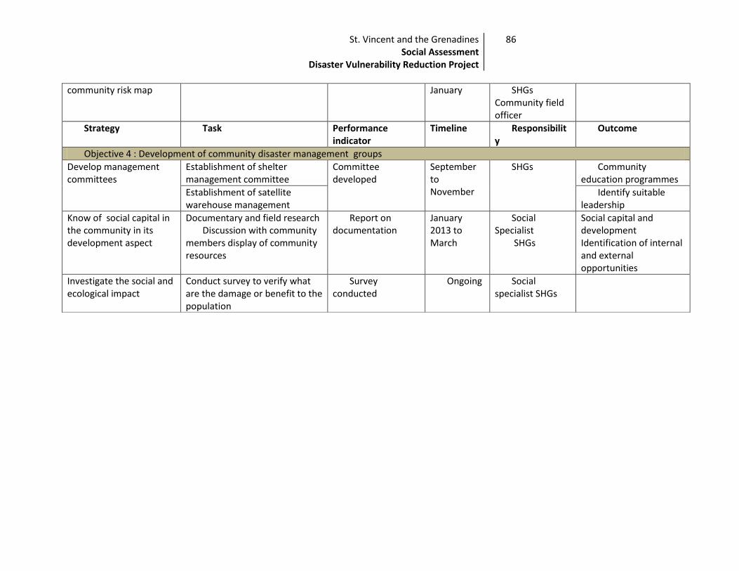
St. Vincent and the Grenadines Social Assessment
Disaster Vulnerability Reduction Project
86
community risk map January SHGs Community field officer
Strategy Task Performance indicator
Timeline Responsibility
Outcome
Objective 4 : Development of community disaster management groups
Develop management committees
Establishment of shelter management committee
Committee developed
September to November
SHGs
Community education programmes
Establishment of satellite warehouse management
Identify suitable leadership
Know of social capital in the community in its development aspect
Documentary and field research Discussion with community
members display of community resources
Report on documentation
January 2013 to March
Social Specialist
SHGs
Social capital and development Identification of internal and external opportunities
Investigate the social and ecological impact
Conduct survey to verify what are the damage or benefit to the population
Survey conducted
Ongoing Social specialist SHGs

List of contact:
Point Persons Agency/Organisation Email
Mr. Brent Bailey Ministry of Transportation and Works
Mr. Nikolai Lewis Ministry of Transportation and Works
Mr. Hudson Nedd Ministry of Housing
Ms. Saskia Scotland Ministry of Housing
Ms. Michelle Forbes NEMO [email protected]
Roxanne Williams NEMO
Mr. Edmund Jackson [email protected] [email protected]
Ms. Yasa Belmar [email protected] [email protected]
Errol Cain Radio Rainbow League [email protected]
Mr. Sylvester Tannis Radio Rainbow League [email protected]
Edwin Durrant SVG Coast Guard Service
Mr. Andre Alexander
Ministry of Telecommunication
Ms. Ronette Jordan Central Planning Division
Members St. Vincent Boys Grammar School Young Leaders
Members GHS – Young Leaders
Members Green Hill Sport and Cultural Organisation
Members Marriaqua
Members Buccament Development Organisation
Dolly Prescott Marriaqua Community Member
Devern London Marriaqua Community Member [email protected]
Catherine John Marriaqua Community Member
Wanda Dascent Marriaqua Community Member [email protected]
Leonard Cordice Marriaqua Community Member
Noble Davis Marriaqua Community Member
Stanley Stephens Marriaqua Community Member [email protected]
Glaudeus –Myers Buccament
Diam Hickson Samuel Buccament
Norma Browne Buccament
Kathleen Prescott Buccament

St. Vincent and the Grenadines Social Assessment
Disaster Vulnerability Reduction Project
88
Othniel Browne
Amor Jackson
Training
NAME Area assign
Sandra Augustus Troumaca
Amor Jackson Buccament /Grenadines
Yoland London Spring / Grenadines
Dwight Samuel Spring
St. Clair Yearwood Georgetown
Fiara Castello Kingstown
Learie Johnson Georgetown
Catherine John Marriaqua
Nola Craigg Arnos Vale
Karen J. Nero Arnos Vale
Roger Young
Everal INCE Chateaubelair Baliene
Donnette Pierre Colonaire
Shamanth Labban Colonaire
Philcol Jeffers Barrouallie
Glaston Lavia Sandy Bay/ Fancy
Gwenneth Anthony Marriaqua
Sandy Bay
NAME GEN
DER
COMMUNITY
Hoyte Alford M Biabou
Jordon Ronette F CPD
Ralph De-Anna F CPD
Stewart Chiaka F CPD
Peters Hulda F NEMO
OSMENT Kendol M Sandy Bay
Hoyte Nesta F Sandy Bay
May Andrea F Sandy Bay Walter St.
Elbert
M Sandy Bay
Ballantyne
Peters
M Sandy Bay
Hepburn
Sheldon
M Sandy Bay
Lavia Alex M Sandy Bay Ballantyne
Christian
M Sandy Bay
Fraser Patsy F Sandy Bay Locke Justin M WB
Oppong Yaa F WB
St. Vincent and the Grenadines Social Assessment
Disaster Vulnerability Reduction Project
89
ANNEX 1
St. Vincent and the Grenadines Disaster Vulnerability Reduction Project
Terms of Reference for a SOCIAL ASSESSMENT
August 15, 2010 1. Introduction The purpose of these Terms of Reference (TOR’s) is to identify the nature, scope and
extent of the social assessment to be undertaken during the preparation of the St. Vincent and the Grenadines Disaster Vulnerability Reduction Project (DVRP). The Social Assessment will be undertaken by the social policy specialist. Ms. DeAnna Ralph of the Public Sector Investment Programme Management Unit, with guidance from the World Bank’s social Development Specialist.
2. Background Information St. Vincent and the Grenadines is among the most disaster-prone countries in the
world, regularly suffering disasters related to natural events such as earthquake, hurricane, landslide, rain and drought. These hazards have caused significant and recurrent damages to national infrastructure including housing, road networks, schools, hospitals and other facilities such as phone lines, water and electricity. The resulting impacts significantly affect human welfare, national economic activities, property, and natural resources. The effects of climate change are already evident in many parts of the country with rising sea levels and storm activity continuing to impact on exposed coastlines and development. The situation is only expected to worsen as SVG is highly vulnerable to the impacts of global warming and climate associated impacts.
Over the last decade, SVG began its risk reduction activities with the development of disaster preparedness and response investments. During this period, most of the activity in disaster risk reduction focused on the development of national disaster plans, setting up the disaster management agency, and promoting public education and awareness. Despite these efforts, SVG continues to face high levels of risk to its economic stability and national welfare. Post-disaster rehabilitation of damaged infrastructure is a major contributor to the national economic risk profile.
Studies have documented that aging public infrastructure presents very high levels of vulnerability, particularly in critical sectors such as health, education, water, and roads. The annual tropical storm/hurricane season, combined with the cumulative effects of climate change, will continue to threaten island economies. Without intervention, this will likely increase the future need to divert limited financial resources
St. Vincent and the Grenadines Social Assessment
Disaster Vulnerability Reduction Project
90
away from economic growth activities into repairs and reconstruction as a result of disaster and climate change events. While work continues in preparedness and response, the logical next step is reduction of vulnerability to infrastructure.
Project Objectives
The project for which this social assessment is being developed would seek to measurably decrease the vulnerability of people and the national economy of SVG to climate change and natural hazards. The development objectives of the project would be to: (i) integrate disaster vulnerability reduction and climate resilience in national development strategies and management of public infrastructure; (ii) improve SVG’s access to and benefit from regional collaboration and support structures for hazard monitoring and risk assessments, and (iii) reduce the risk of loss of human life due to natural hazard induced structural failure of critical public infrastructure.
3. Purpose of Social Assessment
The social assessment will a) analyze the potential social impacts of the project and develop associated social indicators for monitoring and evaluating the social impacts of the project, b) solicit stakeholder/beneficiary perspectives on project design and impact and c) identify and assess the nature and magnitude of land acquisition related issues. The social assessment will assist in the identification of poor and vulnerable populations and ensure that project objectives are acceptable to the intended beneficiaries.
Specifically, the SA will serve as a: I. Baseline data collection tool in each of the project sites and a means to identify
a. Stakeholder analysis (including those who can influence the project outcome, e.g. NGOs? etc) and their roles, responsibilities and priorities in the various project locations.
b. Social diversity and gender profile of project beneficiaries including the identification of key socio-economic characteristics of the communities including their livelihood strategies and characteristics (gender, age, poverty, disability status etc.). What are the cultural and social features that differentiate social groups in the various project areas and who are the poor and vulnerable?
c. Potential social impacts of the project including opportunities and risks among the differentiated stakeholder groups outlined above in each project site.
d. Key institutions (formal and informal organizations) likely to affect the project and relationships between project beneficiaries/ stakeholders and institutions.
e. Key social indicators for monitoring and evaluating potential project impacts on the identified groups.

St. Vincent and the Grenadines Social Assessment
Disaster Vulnerability Reduction Project
91
II. Consultation and participation tool to:
a. Consult with project beneficiaries (paying particular attention to otherwise excluded groups) and to identify and document what communities want in terms of information/ community level engagement.
b. Identify stakeholder opportunities to influence project design as well as social risks.
c. Better understand the nature, scope and magnitude land acquisition issues in each project site as well as land ownership and strategies to mitigate potentially adverse impacts as well as to inform project affected peoples of project plans.
d. Prepare a participation plan for the project. e. The findings from this analysis and consultation will be incorporated into
the project design and resettlement processes; 4. Expected Outputs The outputs should include:
(a) Consultation Strategy. Documented consultations (and their outcomes) with project affected peoples/project beneficiaries and the development of a consultation strategy for the project going forward;
(b) Monitoring and evaluation plan: The assessment should provide a framework, including indicators and institutional arrangements, for monitoring the social impacts of the project.
(c) Recommendations for project design and implementation arrangements:
Provide input to the RPF and Resettlement Action Plans and link SA findings to resettlement policy framework when appropriate including an estimate of the numbers and categories of affected peoples at the sites identified as triggering OP/BP 4.12.
(d) Identification of poor and vulnerable populations and assessment of how the project might best respond to/address reduction of vulnerability of the poor. 5. Data collection and research methods: Build on existing data and review all
relevant literature (e.g past NEMO consultations) as well as any ongoing and relevant activities. The consultant is expected to use relevant and appropriate research methods such as rapid user surveys, consultations and stakeholder workshops and key informant interviews as necessary with project affected people/beneficiaries/institutions in each of the project sites paying particular attention to the poorest and most vulnerable communities.
The SA should be carried out in parallel to the development of the Resettlement Policy Framework and the key findings should be included in the RPF.

St. Vincent and the Grenadines Social Assessment
Disaster Vulnerability Reduction Project
92
6. Team: Ms. DeAnna Ralph has been identified as the social scientist who will
design, conduct and write up the results of the social assessment with input – where necessary - from the affiliated ministries, particularly Housing.
7. Schedule and Reporting
Level of effort = approximately 30 days
Develop a research plan with research methodology (data collection methods, units of analysis, interview questions/guidelines) timeline and outputs and submit to the Bank for review prior to the commencement of field research. This initial report should include a comprehensive update of the summary table below.
Prepare a draft report and submit to the Bank.
Incorporate Bank input and prepare final report.
Submit final report to the Bank prior to project appraisal.
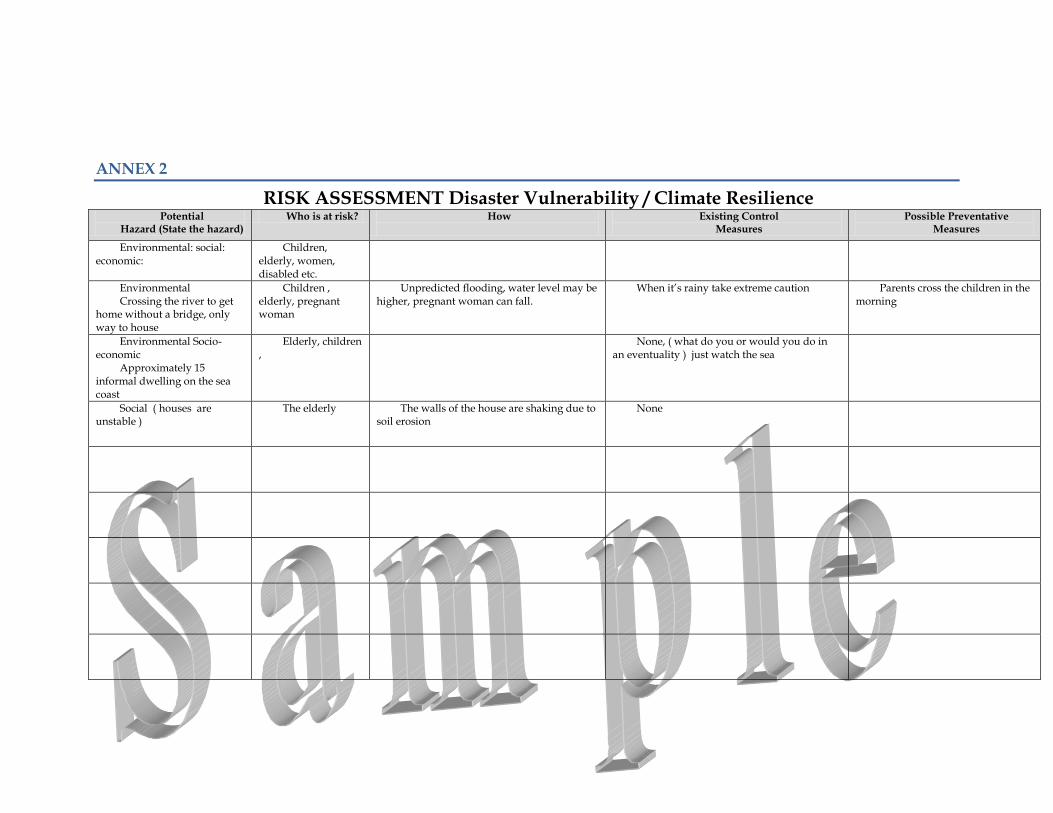
ANNEX 2
RISK ASSESSMENT Disaster Vulnerability / Climate Resilience Potential
Hazard (State the hazard) Who is at risk? How
Existing Control
Measures Possible Preventative
Measures
Environmental: social: economic:
Children, elderly, women, disabled etc.
Environmental Crossing the river to get
home without a bridge, only way to house
Children , elderly, pregnant woman
Unpredicted flooding, water level may be higher, pregnant woman can fall.
When it’s rainy take extreme caution Parents cross the children in the morning
Environmental Socio-economic
Approximately 15 informal dwelling on the sea coast
Elderly, children ,
None, ( what do you or would you do in an eventuality ) just watch the sea
Social ( houses are unstable )
The elderly The walls of the house are shaking due to soil erosion
None
Documents
The Town and Country Planning Act No.45 of 1992 The Central Water and Sewerage Act of 1992 The Waste Management Act, No. 31 of 2000 The Environmental Services Act No. 14 of 1991 The Environmental Health Services Act No. 15 of 1991 The National Emergency and Disaster Management Act of 2006
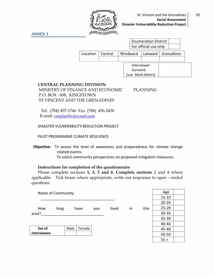
St. Vincent and the Grenadines Social Assessment
Disaster Vulnerability Reduction Project
95
ANNEX 3
CENTRAL PLANNING DIVISION MINISTRY OF FINANCE AND ECONOMIC PLANNING
P.O. BOX 608, KINGSTOWN ST VINCENT AND THE GRENADINES Tel. (784) 457-1746 Fax. (784) 456-2430 E-mail: [email protected] DISASTER VULNERABILITY REDUCTION PROJECT PILOT PROGRAMME CLIMATE RESILIENCE
Objective: To assess the level of awareness and preparedness for climate change related events.
To solicit community perspectives on proposed mitigation measures. Instructions for completion of the questionnaire Please complete sections 1, 3, 5 and 6. Complete sections 2 and 4 where
applicable. Tick boxes where appropriate, write out responses to open – ended questions.
Name of Community:
___________________________________ How long have you lived in this
area?______________________________
Enumeration District
For official use only
Location Central Windward Leeward Grenadines
Interviewer Surname
(use block letters)
Age
15-19
20-24
25-29
30-34
35-39
40-44
45-49
50-54
55 +
Sex of interviewee
Male Female

St. Vincent and the Grenadines Social Assessment
Disaster Vulnerability Reduction Project
96
SECTION 1- GENERAL This section deals with community members’ experience of natural
disaster. It is to be answered by all interviewees.
1. Which of the following natural disasters are you likely to be affected by in your community? ( multiple responses can be selected)
EVENTS NOT AT ALL
NOT
LIKELY
SELDOM
LIKELY
VERY LIKELY
Floods
Landslides
Soil erosion
Tropical storms /hurricanes
Drought
Storm Surges
Earthquakes
Volcanic eruptions
Agricultural pest
High winds
Other please specify
2. Have any of these impacted on your life, health, property, livelihood, environment in the past 5 years?
If Yes, please continue by stating which ones and what aspect. If no, Please skip go to question 4
Events Life
(way of life)
Health
(injury)
Property
(damage)
Livelihood (earni
ngs)
Environment
(Surrounding)
Other Please state:
Floods
Landslides
Soil erosion
Tropical storms /hurricanes
Drought
Storm Surges

St. Vincent and the Grenadines Social Assessment
Disaster Vulnerability Reduction Project
97
Earthquakes
Volcanic eruptions
Agricultural plagues
High winds
Other please specify
3. How would you rate the level of impact of these events?
Level of Impact
Events Not at all
Very Low
Low High Very high
Not exposed to this event
Floods
Landslides
Soil erosion
Tropical storms /hurricanes
Drought
Storm Surges
Earthquakes
Volcanic eruptions
Agricultural plagues
High winds
Other please specify
4. What social problems are most common in this community? Rate the level of occurrence from very low to very high.
FREQUENCY LEVEL
Very low
Low High
Very high
Not sure
NOT a problem
Youth unemployment
Adult unemployment
Teenage pregnancy
Drug use/abuse
Drug dealing
Domestic violence

St. Vincent and the Grenadines Social Assessment
Disaster Vulnerability Reduction Project
98
Violence against women
Violence
Theft / Burglary
Predial Larceny
Gang violence
Poverty
School drop outs
HIV/AIDS
Other, Please specify
5. Please rate what level of impact would a natural disaster have on the services in your community.
None at all
low
Not Sure
high impact
Very high impact
Community does not have this service
The school
The health Clinic
Community or resource centre
Police station
Roads
Telephones
Electricity
Water
Other, Please Specify
6. How prepared are you for another eventuality? (related to natural disaster)
A. Don’t believe in preparation
B. Not prepared at all
C. Somewhat prepared
A
b
c

St. Vincent and the Grenadines Social Assessment
Disaster Vulnerability Reduction Project
99
D. Prepared
E. Very prepared
F. Would prepare in the future
7. What do you think is needed for you to be more prepared? List options (e.g home
repairs, information etc,)
______________________________________________________________________________________________________________________________________________
8. What is your main source of water supply
a) Pipe borne CWSA
b) River
c) Collecting rain water
d) Public pipes
e) Other, Please Specify_____________________________________
9. In the event of a disruption in the water supply from CWSA. How would this affect you?
Not at all Very much
1 2 3 4 5
10. Do you have alternative water storage facilities?
Yes No If no go to question 13
11. If Yes, state types
(a) Plastic tanks
(b) Concrete tanks
(c) Drums
(d) Water jugs
d
e
f
a
b
c
a
b
c
d
e
d
St. Vincent and the Grenadines Social Assessment
Disaster Vulnerability Reduction Project
100
(e) Buckets
(f) Cisterns (underground storage)
(g) Other, please specify ___________________________
12. How long would this water last you, if the main water source was shut down due to natural disasters?
a. less than a day
b. a little less than a week
c. 1-2 weeks
d. 2 weeks to a month
e. More than a month
GO TO NEXT SECTION
13. Why not a. Too expensive
b. Not enough space
c. not necessary
d. Other, Please specify ___________________________________
f
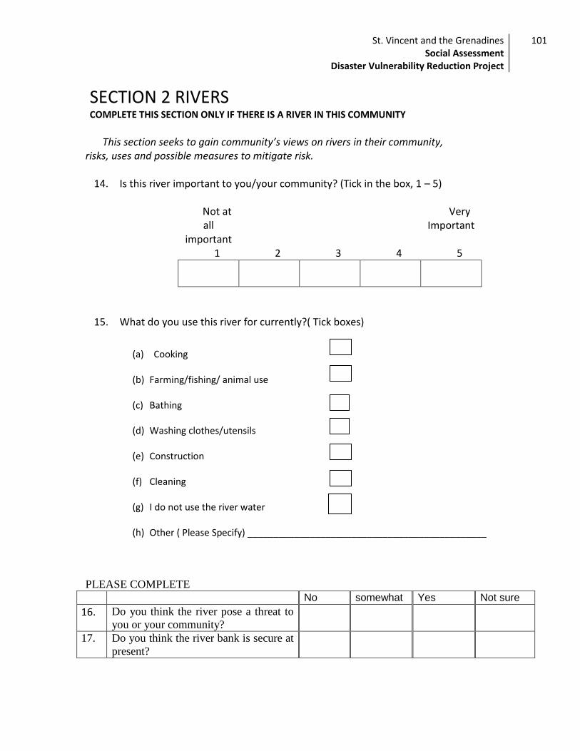
St. Vincent and the Grenadines Social Assessment
Disaster Vulnerability Reduction Project
101
SECTION 2 RIVERS COMPLETE THIS SECTION ONLY IF THERE IS A RIVER IN THIS COMMUNITY
This section seeks to gain community’s views on rivers in their community,
risks, uses and possible measures to mitigate risk.
14. Is this river important to you/your community? (Tick in the box, 1 – 5)
Not at all
important
Very Important
1 2 3 4 5
15. What do you use this river for currently?( Tick boxes)
(a) Cooking
(b) Farming/fishing/ animal use
(c) Bathing
(d) Washing clothes/utensils
(e) Construction
(f) Cleaning
(g) I do not use the river water
(h) Other ( Please Specify) ______________________________________________
PLEASE COMPLETE
No somewhat Yes Not sure
16. Do you think the river pose a threat to
you or your community?
17. Do you think the river bank is secure at
present?
f
b
c
d
e
a
g

St. Vincent and the Grenadines Social Assessment
Disaster Vulnerability Reduction Project
102
18. Do you think it is necessary to further secure the bank of the river?
Yes No:
If yes, What do you think can be done to protect the river bank ?
___________________________________________________________________________
______________________________________________________________________________
______________________________________________________________________________
________________________
19. Have you noticed any changes in the river pattern? Yes No: (If no go to question 20) If yes, please explain
_______________________________________________________________________________________________________________________________________________________________________________________________________________________________________________________________
(B) What do you think is responsible for these changes
_______________________________________________________________________________________________________________________________________________________________________________________________________________________________________________________________
20. What do you think would happen if nothing was done to change the situation? ___________________________________________________________________________
______________________________________________________________________________
________________

St. Vincent and the Grenadines Social Assessment
Disaster Vulnerability Reduction Project
103
SECTION 3. SLOPE STABILIZATION:
21. Which of the following are currently considered a problem in your community?
Tick appropriate
boxes
Rock fall
Cracks in the land
Landslides
Land slippage
Water logged soil
Soil erosion
None of the above
Other: Please specify________________________________.
22. Do you feel these problems pose a danger or threat to you or your community?
Level of THREAT
Events Not at all
Very Low
Low High Very high
Not exposed to this event
Rock fall
Cracks in the land
Landslides
Land slippage
Water logged soil
Soil erosion
Other please specify
23. What is your land being used for currently?( Tick boxes)
(a) Housing
(b) Farming/ animal use b
c
a

St. Vincent and the Grenadines Social Assessment
Disaster Vulnerability Reduction Project
104
(c) Business
(d) Vacant lot
(e) Other ( Please Specify) ______________________________________________
24. Have you noticed any recent changes in the land stability in your community? (Landslides, swamps, new streams etc.)
Yes No: if, no go on to question 25.
If yes, please explain
__________________________________________________________________________________________________________________________________________________________________________________________________________________________________________
(B) What do you think is responsible for these changes ___________________________________________________________________________
____________________________________________________________________________________________________________________________________________________________
25. Do you think it is necessary to further secure the land from erosion, landslides, etc ?
Yes No: .
Please explain
____________________________________________________________________________________________________________________________________________________________
26. What do you think is needed to protect the area? ___________________________________________________________________________
____________________________________________________________________________________________________________________________________________________________________________________
27. What do you think would happen if nothing was done to change the situation? ___________________________________________________________________________
_______________________________________________________________________________________________
d
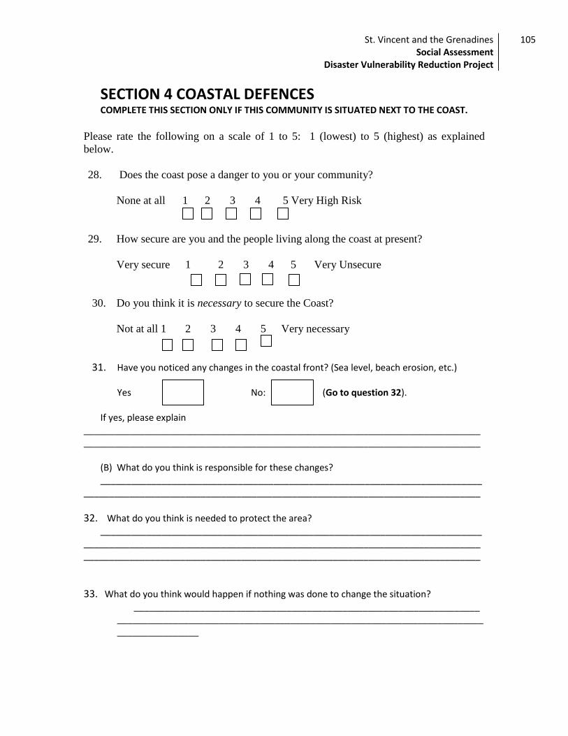
St. Vincent and the Grenadines Social Assessment
Disaster Vulnerability Reduction Project
105
SECTION 4 COASTAL DEFENCES COMPLETE THIS SECTION ONLY IF THIS COMMUNITY IS SITUATED NEXT TO THE COAST.
Please rate the following on a scale of 1 to 5: 1 (lowest) to 5 (highest) as explained
below.
28. Does the coast pose a danger to you or your community?
None at all 1 2 3 4 5 Very High Risk
29. How secure are you and the people living along the coast at present?
Very secure 1 2 3 4 5 Very Unsecure
30. Do you think it is necessary to secure the Coast?
Not at all 1 2 3 4 5 Very necessary
31. Have you noticed any changes in the coastal front? (Sea level, beach erosion, etc.)
Yes No: (Go to question 32). If yes, please explain
____________________________________________________________________________________________________________________________________________________________
(B) What do you think is responsible for these changes? ___________________________________________________________________________
______________________________________________________________________________
32. What do you think is needed to protect the area? ___________________________________________________________________________
____________________________________________________________________________________________________________________________________________________________
33. What do you think would happen if nothing was done to change the situation? ____________________________________________________________________
________________________________________________________________________________________
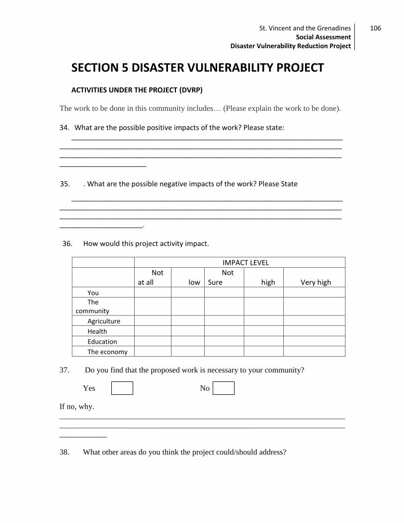
St. Vincent and the Grenadines Social Assessment
Disaster Vulnerability Reduction Project
106
SECTION 5 DISASTER VULNERABILITY PROJECT ACTIVITIES UNDER THE PROJECT (DVRP)
The work to be done in this community includes… (Please explain the work to be done).
34. What are the possible positive impacts of the work? Please state:
_______________________________________________________________________________________________________________________________________________________________________________________________________________________________________________________________
35. . What are the possible negative impacts of the work? Please State
______________________________________________________________________________________________________________________________________________________________________________________________________________________________________________________________.
36. How would this project activity impact.
IMPACT LEVEL
Not at all low
Not Sure high Very high
You
The community
Agriculture
Health
Education
The economy
37. Do you find that the proposed work is necessary to your community?
Yes No
If no, why.
________________________________________________________________________
________________________________________________________________________
____________
38. What other areas do you think the project could/should address?
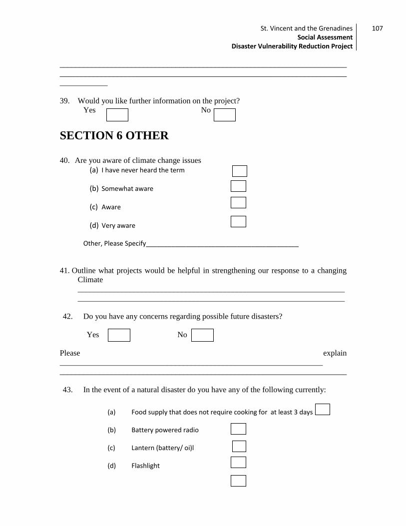
St. Vincent and the Grenadines Social Assessment
Disaster Vulnerability Reduction Project
107
________________________________________________________________________
________________________________________________________________________
____________
39. Would you like further information on the project?
Yes No
SECTION 6 OTHER
40. Are you aware of climate change issues
(a) I have never heard the term
(b) Somewhat aware
(c) Aware
(d) Very aware
Other, Please Specify__________________________________________
41. Outline what projects would be helpful in strengthening our response to a changing
Climate
___________________________________________________________________
___________________________________________________________________
42. Do you have any concerns regarding possible future disasters?
Yes No
Please explain
__________________________________________________________________
________________________________________________________________________
43. In the event of a natural disaster do you have any of the following currently:
(a) Food supply that does not require cooking for at least 3 days
(b) Battery powered radio
(c) Lantern (battery/ oi)l
(d) Flashlight
b
c
d
e
a
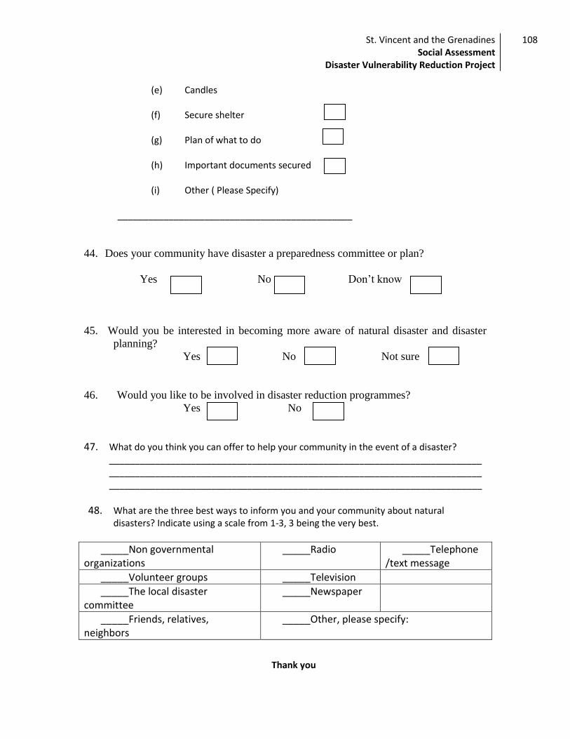
St. Vincent and the Grenadines Social Assessment
Disaster Vulnerability Reduction Project
108
(e) Candles
(f) Secure shelter
(g) Plan of what to do
(h) Important documents secured
(i) Other ( Please Specify)
______________________________________________
44. Does your community have disaster a preparedness committee or plan?
Yes No Don’t know
45. Would you be interested in becoming more aware of natural disaster and disaster
planning?
Yes No Not sure
46. Would you like to be involved in disaster reduction programmes?
Yes No
47. What do you think you can offer to help your community in the event of a disaster? ___________________________________________________________________________________________________________________________________________________________________________________________________________________________
48. What are the three best ways to inform you and your community about natural disasters? Indicate using a scale from 1-3, 3 being the very best.
_____Non governmental organizations
_____Radio _____Telephone /text message
_____Volunteer groups _____Television
_____The local disaster committee
_____Newspaper
_____Friends, relatives, neighbors
_____Other, please specify:
Thank you
f
g
h
St. Vincent and the Grenadines Social Assessment
Disaster Vulnerability Reduction Project
109
Annex 4 Community of Sandy Bay
SAINT VINCENT AND THE GRENADINES
REGIONAL DISASTER VULNERABILITY REDUCTION PROJECT (RDVRP)
ANNEX TO SOCIAL ASSESSMENT
COMMUNITY OF SANDY BAY
April 2012
St. Vincent and the Grenadines Social Assessment
Disaster Vulnerability Reduction Project
110
Table of Contents
1. Rationale ....................................................................................................................... 111
2. Social Assessment Objective .................................................................................... 111
3. INVESTIGATION DESIGN: .............................................................................................. 111
4. EXTRA DUE DILIGENCE .................................................................................................. 112
5. Diagnostic of Community: ............................................................................................ 112
6. Key Social Findings ................................................................................................... 114
7. Risk Assessment ............................................................................................................ 117
8. Next Steps ..................................................................................................................... 117
St. Vincent and the Grenadines Social Assessment
Disaster Vulnerability Reduction Project
111
1. Rationale
The Regional Disaster Vulnerability Reduction Project (RDVRP) is being
implemented in Saint Vincent and the Grenadines (SVG). The initial social scoping of the project and subsequent social assessment indicated the presence of a Garifuna population in the project site of Sandy Bay. Therefore, it was determined that an assessment needed to be made as to whether the community met the requirements laid out in the Bank’s policy on Indigenous people (O.P 4.10) and whether the policy was therefore triggered. It was concluded that while the community (Sandy Bay) self identify (and are also identified by others) as being a distinct indigenous community and while they do occupy a specific geographical location, they do not have distinctive customary cultural, economic, social or political institutions that are separate from the dominant society and culture, nor do they have an indigenous language different from the official language (English) of St. Vincent and the Grenadines.
In sum, while the community possesses some of the attributes necessary to trigger the World Bank’s policy on Indigenous Peoples they do not fully meet the criteria and it has been decided (by mutual consent) by the World Bank and the Government of St. Vincent and The Grenadines that the policy is not triggered in the case of the Garifuna population.
Nevertheless, it was felt that it was important to conduct “extra due diligence” on these communities to ensure that project impacts are positive and that any potentially negative impacts are successfully mitigated, particularly given the higher than average poverty rates among the community.
The planned intervention in Sandy Bay under the RDVRP is the construction of a Satellite Warehouse which seeks to provide for basic emergency resources in the event of a natural disaster - thus, reducing the vulnerability of the communities.
2. Social Assessment Objective
A Social Assessment was undertaken during project preparation to assist in the identification of potential social benefits and potential negative impacts. Specifically the aim was to identify potential positive and negative impacts associated with the construction of the Satellite Warehouse in Noel Sandy Bay.
3. INVESTIGATION DESIGN: The methods used in the development of the Social Assessment were as follows:
(a) Type of study: Exploratory
(b) Method Deductive
(c) Techniques and Instruments
Techniques Instruments
Documental or Desk research Maps

St. Vincent and the Grenadines Social Assessment
Disaster Vulnerability Reduction Project
112
4. EXTRA DUE DILIGENCE
Sampling Method to ensure extra due diligence in Sandy Bay. A Survey was conducted at all project sites. A representative sample was selected by the Census office based on the population on each census division. A number of 7 persons were suggested to be interviewed in Sandy Bay however, the survey was conducted on 37 persons in order to ensure extra due diligence.
This included persons in close proximity to project sites, persons living near to rivers, persons living near to the coast, residents of communities near the coast and persons who own lands or operate businesses in the communities of interest. Similarly, discussions and informal interviews were held with key personnel, who, through participation in community/ environmental organisations or previous experience with disaster, made them of interest to the assessment.
Respondent Note on Methodology: Key informant interviews in the communities of Sandy Bay and Fancy noted that
these areas are of particular interest to many External groups due to high levels of poverty and the possible presence of Indigenous People.
Social Assessment Response The Social Assessment Team notes that these communities have also been subject to
increased scrutiny and participatory research, and instead employed the use of key informants to ensure that quality data was collected.
1. Obtaining the Information:
- Community Development Officer was identified
- The Director of the Sandy Bay Government School
- An anthropologist living in the Sandy Bay Area
- Community members
- Children from the School
5. Diagnostic of Community:
Interviews Risk assessment
Observation Observation guide
Site visit Surveys
Community discussion Focus groups
St. Vincent and the Grenadines Social Assessment
Disaster Vulnerability Reduction Project
113
OPERATIONAL DEFINITION: (A) It’s a rural community from the mouth of the Noel River on the coast in a
westerly direction. All the way to its source in the Waterloo Mountains in the
vicinity of the parish boundary, then northward along Acayau River to the coast
at Belleisle Gutter, then along the coast back to the start.
(B) The parish is Charlotte. its geographical coordinates are 13° 21' 0" North, 61° 8'
0"
(C) Problems identified by the community study for the RDVRP
- Poverty
- High unemployment
- Teen pregnancy
- High vulnerability to natural disaster
- Landslides
- Sea blast
- Coastal erosion
Location: Sandy Bay is a rural coastal village on the North Windward coast of St. Vincent and
the Grenadines in the parish of Charlotte. It lies approximately four (4) miles north of Georgetown (a main town on St. Vincent Island) and south of the La Soufriere Volcano. The community is also in close proximity to one of the island deadliest rivers, the Rabacca Dry River. This river, which flows directly from the volcano for regularity is DRY in nature but very powerful when flowing. The village is accessible by land and sea.
Background: The village comprises of two (2) major sections old Sandy Bay and New Sandy Bay.
The old Sandy Bay section is believed to have existent in 1797 after the Carib wars with the British. The area comprises mainly of decedents of the Yellow Caribs, a small number of African slaves referred to as Black Caribs the ancestors of the Black Caribs became the first permanent non-carib settlers in the island in 1675 mainly survivors from the sinking Dutch ship. During the 1900s the community had numerous upsurges from heavy flooding, hurricanes and volcanic eruption.
Population
St. Vincent and the Grenadines Social Assessment
Disaster Vulnerability Reduction Project
114
The population according to the 2001 census, was two thousand eight hundred and
sixty- seven (2,867). This is the entire Sandy Bay census division that comprises surrounding communities. The economically active population is seven hundred and twenty –two (722) the lowest of all census division in the island, of which 537 are male and 185 are female. The unemployed women are engaged in household chores, while the men seek odd and end tasks.
Livelihood The community livelihood is embedded in subsistence and commercial farming, of
crops including cassava, peas, sorrel and sweet potatoes. Culture The traditional Carib culture is not practiced; however, members of the community
practice the Quadrille dance. November 1 (the day of the Dead) is also celebrated by the cleaning and lighting of candles on their deceased relatives graves. In December, like all other communities in St. Vincent and the Grenadines the members visits each other homes to bring a message of glad tidings and joy.
Family Structure: The family composition is single parents and extended families living in small to
medium size concrete and partly wooden houses. Approximately 96 percent have electricity, and domestic water supply. Telephone in the homes is very common however a number of people have cellular phones. Approximately 15 percent of the population use pit latrines. Teen pregnancy seems to be the dominant social problem in this area.
Physical Infrastructure The institutions present in this community are one (1) health clinic, two (2) pre-
primary schools, one (1) primary and one secondary school, Churches from all religions (Anglican, Catholic, Spiritual Baptist, Adventist, etc.) one resource centre that serves as an office for teachers in the Secondary school, Adult Continued Education Programmes and community meetings. Additionally the community has its´ own radio station, the Garifuna radio, post office, police station, playing field and cemetery. Other businesses that can be found in Sandy Bay include hairdressing, bakery, and retail shops.
6. Key Social Findings
The Social Assessment revealed the need for the project activities to help to reduce the vulnerability of the communities in the event of natural disaster.
Employment opportunities for unemployed youth, men and women on some
the project sites, for example the construction of the satellite warehouse, river
and coastal defence. In Sandy Bay some residents indicated the possibility of
having the opportunity to make basketry to display next to the coastal
defence, thereby improving tourist attraction and create employment.
Coastal Defence: The Coastal defence assessment was conducted in the communities of Sandy Bay.
The coastal front in some areas in St. Vincent and the Grenadines is developmental land

St. Vincent and the Grenadines Social Assessment
Disaster Vulnerability Reduction Project
115
for tourism. Prime beneficiaries of these activities consist of grocery shops operators, landowners. In addition to questionnaires, informal interviews were conducted with entrepreneur living along the coast. In these communities, 95.2 percent of the respondents indicated that this activity was necessary for the community. 92 percent felt that the people living along the coast were unsecure and 90 percent of the respondents felt that it was necessary to secure the coastal front. They anticipate that the sea defence would help in flood and disaster mitigation and highlighted the following positive impacts:
In Sandy Bay respondents anticipated that coastal defence would prevent beach
erosion. This would enable the residents to reintroduce beach sports such as
cricket, football and volleyball. Additionally, this would promote a sense of
security among parents who indicated that their children would be safer while
playing on the beaches.
It would protect properties along the coastal front and provide environmental
beautification.
It would reduce the risk of loss of human life resulting from natural hazards.
Particularly, in the communities of Georgetown and Sandy Bay, which are
located near the Atlantic belt, where residents are endangered as high waves are
frequently observed.
The coastal defence work would protect the infrastructure particularly roads in
some of the communities for example, Sandy Bay and Dark view. The roads in
these two communities are an essential part of the road network and connect
communities (in the north) to the rest of the island.
Generally the residents approve the objectives of this activity and indicated that if not implemented, there can be negative consequences to individuals, communities, the economy and the environment. Some of their responses are presented in the table below.
The respondents say: If the project was not implemented then:
Individual Community Physical Infrastructure Natural Environment
“people living in the area will have to find other places to live”
“many roads and homes along the coast lines will get damaged”
“in the next five years about fifty homes will have to be relocated (SANDY BAY)”
“damages to the beach and people's homes”
“very little or no beaches recreational areas”
“the sea will take more lands”
“the sea will continue taking land until it takes the public road”
“the sea water may continue to reclaim and erode the lands”
“there will be a total cut off in some areas, main road will be destroyed. residents of low lying areas will have to move to higher
“the water will destroy infrastructure like roads and other buildings along the coastline”
“there would be no land for living and in some areas of the community the roads will be completely destroyed”
St. Vincent and the Grenadines Social Assessment
Disaster Vulnerability Reduction Project
116
ground”
Satellite Warehouse at Noel, Sandy Bay: Consultation Sandy Bay Site Visit. A site visit to Sandy Bay was conducted in order to consult
with stakeholders regarding the project in general and location of the Satellite Warehouse specifically. The site visit took place on April 10, 2012. Residents in Sandy Bay were informed of the planned consultation by flyer (see attached) and by local community radio on Sunday April 8. In the event attendance was limited with 9 community members participating (see list of attendees) along with 6 representatives from Central Planning, NEMO and the World Bank. The discussion was a rich one however and the issues raised related to:
The location of the Satellite Warehouse and suggestions by several community members to situate the warehouse on the site of the abandoned Old School more centrally located within the community. The proximity to the sea of the Old School and its ownership by the Anglican Church were discussed. The fact that the suggested location is on Crown Land (thereby circumventing land acquisition) and the broader catchment area of the proposed Warehouse was viewed positively by the community. The pros and cons of the various sites were discussed and ultimately the benefits of the proposed land in terms of an extended catchment area and land ownership status were sufficiently attractive to the community members present.
The procurement process was explained to the community by the PCU Procurement Specialist. The community raised concerns about the importance of hiring local contractors in order to generate employment and concerns that some local contractors might not have the necessary documentation although registered. Community members were assured that contracts will be locally advertised.
Contents of the Satellite Warehouses. The NEMO representative addressed community questions regarding the contents and use of the Warehouse.
Temporary storage of emergency equipment. In addition, with hurricane season fast approaching, it was agreed that a temporary storage site should be established to house some emergency equipment given that the construction of the warehouse could be 6 months or more away. The Principal of the Sandy Bay Government School, Mr. St. Elbert Walters, offered to provide two small storage rooms in the school to house a limited amount of equipment prior to Satellite Warehouse construction.
Emergency Management Committee. The need for a Community Emergency Management Committee was discussed and the need for it to work with District level preparedness groups. Central Planning agreed to assist as necessary in the organization and establishment of the group.
Community Fatigue with Consultations. Several community members expressed frustration with consultations which lead no-where. Examples were given of consultations that have taken place in the past and led by NEMO, the Red Cross and others (unrelated to the RDVRP) which for years have promised Disaster Relief initiatives in Sandy Bay which have not materialized.
Limited Attendance. Limited community attendance was explained in terms of the message not sufficiently getting out and in terms of community fatigue with meetings that lead no-where. It was agreed that a further consultation would be organized during a Parent Teacher Meeting at the Sandy Bay Government School within the next month in order to

St. Vincent and the Grenadines Social Assessment
Disaster Vulnerability Reduction Project
117
reach a wider segment of the community given that construction going ahead in the foreseeable future.
7. Risk Assessment
Community
Potential hazards
Who is at risk
How Existing control
measures
Preventative measures
Sandy Bay
Environmental –socio –economic
Children, elderly, woman, disabled etc.
There is not enough work, hardly any recreational spot
Nil Skill training classes art and craft, etc.
Crossing the river without a bridge – only way to the house
Children, elderly, pregnant women
Unpredicted flooding, water level may be higher, pregnant women may fall
When it´s rainy take extreme caution
Approximately 15 informal dwelling on the sea coast
Elderly, children, women , men, farmers
Sea waves can come to the land and wash away houses and crops
None ¿what do you do in the event of an eventuality? Just watch the sea
Relocate houses
8. Next Steps
The “extra due diligence” on the communities of Sandy Bay has taken the form of a sampling method during the social assessment which sought to “over sample” the community as well as additional consultations during implementation and planned in the coming months. The Satellite Warehouse at Noel (to be situated on Government Land) has been positively greeted by the community and no planned negative social impacts are envisaged under the project,
Community Map

St. Vincent and the Grenadines Social Assessment
Disaster Vulnerability Reduction Project
118