Embed Size (px)
Citation preview
Gotthard Base Tunnel - Mastering surface deformations in the area of two concrete arch dams - innovative solutions Ehrbar, H. 1, Bremen, R. 2, Otto, B. 3 1) AlpTransit Gotthard Ltd, Lucerne, Switzerland 2) Lombardi Ltd., Minusio, Switzerland 3) AXPO Ltd., Baden, Switzerland ABSTRACT The Gotthard Base Tunnel with a total length of 57 kilometres will be the longest railway tunnel of the world when the commercial operation starts in 2016. The tunnel system consists of two single-track tubes with an excavated diameter of 9.40 m. The excavation of the tunnel has been completed in March 2011.
From 2005 to 2011 water saturated jointed rock masses close to two more than 100 m high concrete arch dams had to be excavated in the central Swiss Alps. The Nalps arch dam had to be passed by in a horizontal distance of 600 metres and the Santa Maria arch dam in a distance of 2 kilometres. The vertical distance in both cases was 1’400 metres.
Tunnel excavation in water saturated jointed rock masses causes dewatering of the rock mass around the cavity. The dewatering effects on a large scale can cause measurable deformations at the surface even in the case of deep tunnels. Experiences with these effects have been made 1978 with the damage event of the Zeuzier arch dam in Switzerland and after the opening of the Gotthard road tunnel in 1980. In both cases deformations in the range of 10 centimetres and more have been observed at surface level several hundred meters above the tunnel axis.
In the case of the Gotthard Base Tunnel a sophisticated topographical monitoring system allowed to observe the ground deformations since the earliest beginning of the tunnel excavation in the year 2002 throughout the whole year, also during strong winter times.
Mitigation measures such as impermeabilisation grouting of the rock mass and fissure grouting of the dam structures were defined to avoid unallowable conditions at the two dam sites. Two completely different approaches for the decision making process were used, due to the different boundary conditions.
1 ALIGNMENT OF THE GOTTHARD BASE TUNNEL The following boundary conditions determined the general alignment of the Gotthard Base Tunnel: • Crossing of the tectonic units with difficult ground conditions in the shortest possible
distance, • Minimisation of overburden depths, • Shortest possible length of the access tunnels and the whole tunnel system • No direct undercrossing of the Nalps, Santa Maria and Curnera concrete arch
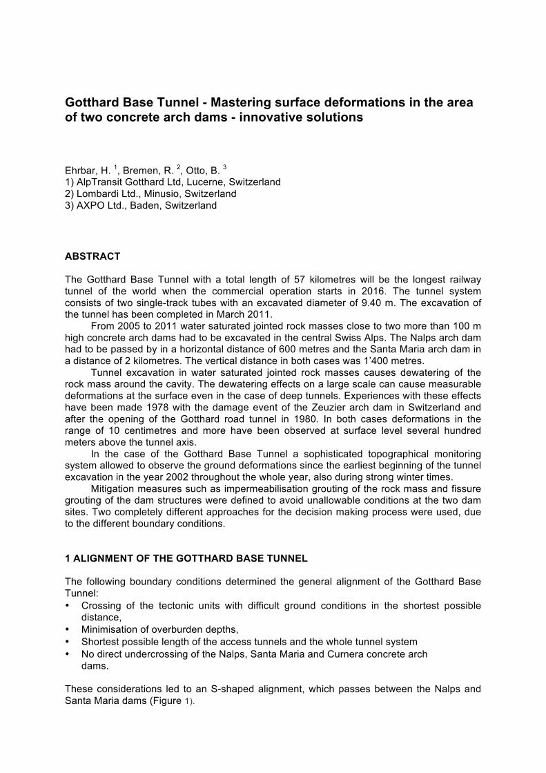
dams. These considerations led to an S-shaped alignment, which passes between the Nalps and Santa Maria dams (Figure 1).
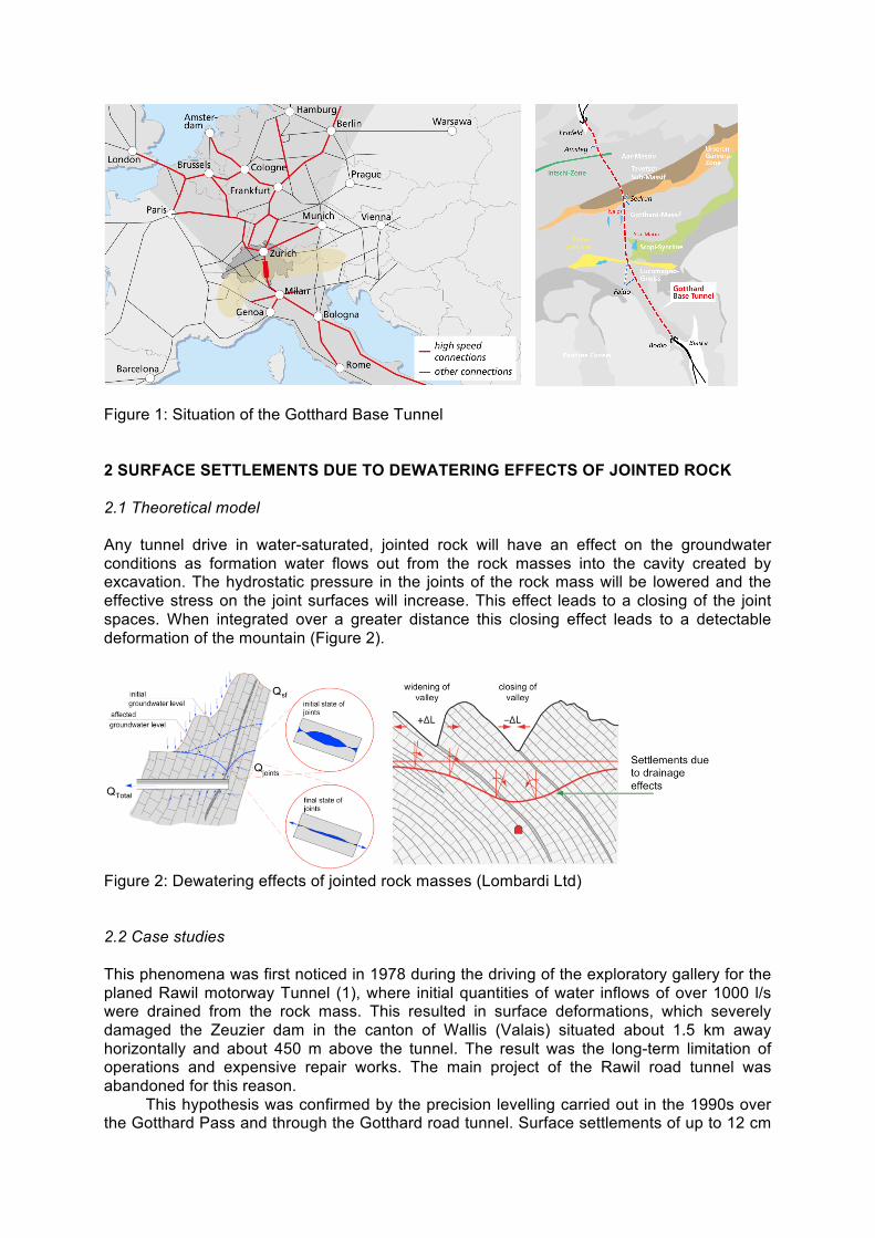
Figure 1: Situation of the Gotthard Base Tunnel 2 SURFACE SETTLEMENTS DUE TO DEWATERING EFFECTS OF JOINTED ROCK 2.1 Theoretical model Any tunnel drive in water-saturated, jointed rock will have an effect on the groundwater conditions as formation water flows out from the rock masses into the cavity created by excavation. The hydrostatic pressure in the joints of the rock mass will be lowered and the effective stress on the joint surfaces will increase. This effect leads to a closing of the joint spaces. When integrated over a greater distance this closing effect leads to a detectable deformation of the mountain (Figure 2).
Figure 2: Dewatering effects of jointed rock masses (Lombardi Ltd) 2.2 Case studies This phenomena was first noticed in 1978 during the driving of the exploratory gallery for the planed Rawil motorway Tunnel (1), where initial quantities of water inflows of over 1000 l/s were drained from the rock mass. This resulted in surface deformations, which severely damaged the Zeuzier dam in the canton of Wallis (Valais) situated about 1.5 km away horizontally and about 450 m above the tunnel. The result was the long-term limitation of operations and expensive repair works. The main project of the Rawil road tunnel was abandoned for this reason.
This hypothesis was confirmed by the precision levelling carried out in the 1990s over the Gotthard Pass and through the Gotthard road tunnel. Surface settlements of up to 12 cm
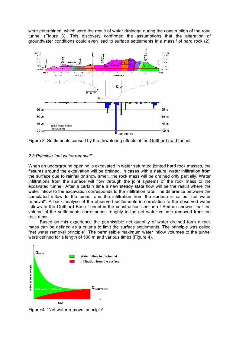
were determined, which were the result of water drainage during the construction of the road tunnel (Figure 3). This discovery confirmed the assumptions that the alteration of groundwater conditions could even lead to surface settlements in a massif of hard rock (2).
Figure 3: Settlements caused by the dewatering effects of the Gotthard road tunnel 2.3 Principle “net water removal” When an underground opening is excavated in water saturated jointed hard rock masses, the fissures around the excavation will be drained. In cases with a natural water infiltration from the surface due to rainfall or snow smelt, the rock mass will be drained only partially. Water infiltrations from the surface will flow through the joint systems of the rock mass to the excavated tunnel. After a certain time a new steady state flow will be the result where the water inflow to the excavation corresponds to the infiltration rate. The difference between the cumulated inflow to the tunnel and the infiltration from the surface is called “net water removal". A back analyse of the observed settlements in correlation to the observed water inflows to the Gotthard Base Tunnel in the construction section of Sedrun showed that the volume of the settlements corresponds roughly to the net water volume removed from the rock mass.
Based on this experience the permissible net quantity of water drained form a rock mass can be defined as a criteria to limit the surface settlements. The principle was called “net water removal principle". The permissible maximum water inflow volumes to the tunnel were defined for a length of 500 m and various times (Figure 4).
Figure 4: “Net water removal principle”
initial water inflow (per 200 m)
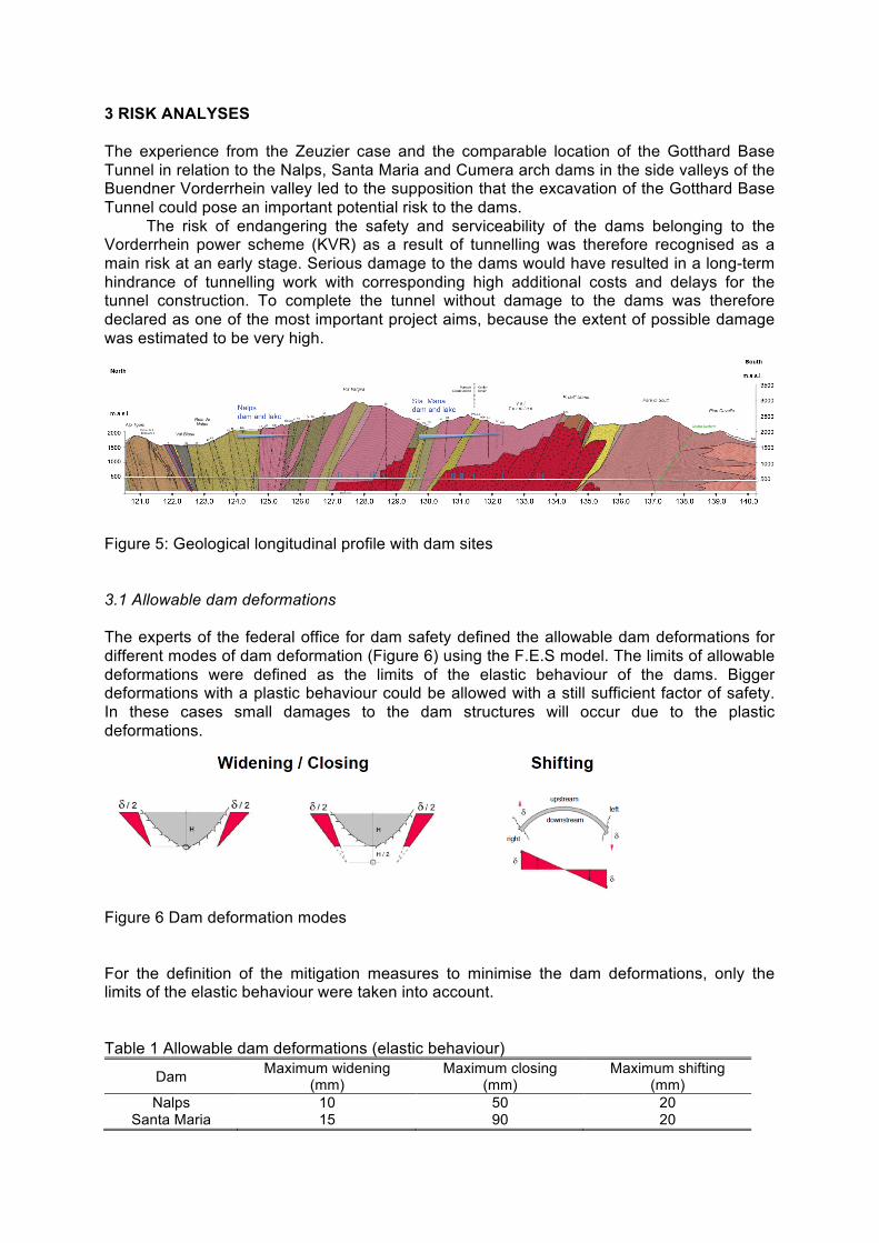
3 RISK ANALYSES The experience from the Zeuzier case and the comparable location of the Gotthard Base Tunnel in relation to the Nalps, Santa Maria and Cumera arch dams in the side valleys of the Buendner Vorderrhein valley led to the supposition that the excavation of the Gotthard Base Tunnel could pose an important potential risk to the dams.
The risk of endangering the safety and serviceability of the dams belonging to the Vorderrhein power scheme (KVR) as a result of tunnelling was therefore recognised as a main risk at an early stage. Serious damage to the dams would have resulted in a long-term hindrance of tunnelling work with corresponding high additional costs and delays for the tunnel construction. To complete the tunnel without damage to the dams was therefore declared as one of the most important project aims, because the extent of possible damage was estimated to be very high.
Figure 5: Geological longitudinal profile with dam sites
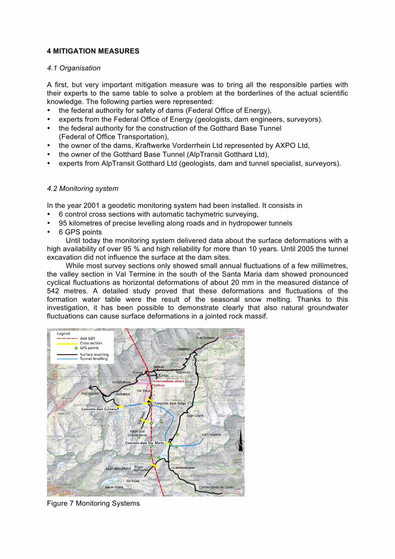
3.1 Allowable dam deformations The experts of the federal office for dam safety defined the allowable dam deformations for different modes of dam deformation (Figure 6) using the F.E.S model. The limits of allowable deformations were defined as the limits of the elastic behaviour of the dams. Bigger deformations with a plastic behaviour could be allowed with a still sufficient factor of safety. In these cases small damages to the dam structures will occur due to the plastic deformations.
Figure 6 Dam deformation modes For the definition of the mitigation measures to minimise the dam deformations, only the limits of the elastic behaviour were taken into account. Table 1 Allowable dam deformations (elastic behaviour)
Dam Maximum widening (mm)
Maximum closing (mm)
Maximum shifting (mm)
Nalps 10 50 20 Santa Maria 15 90 20
4 MITIGATION MEASURES 4.1 Organisation A first, but very important mitigation measure was to bring all the responsible parties with their experts to the same table to solve a problem at the borderlines of the actual scientific knowledge. The following parties were represented: • the federal authority for safety of dams (Federal Office of Energy), • experts from the Federal Office of Energy (geologists, dam engineers, surveyors). • the federal authority for the construction of the Gotthard Base Tunnel
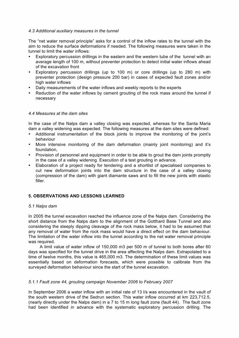
(Federal of Office Transportation), • the owner of the dams, Kraftwerke Vorderrhein Ltd represented by AXPO Ltd, • the owner of the Gotthard Base Tunnel (AlpTransit Gotthard Ltd), • experts from AlpTransit Gotthard Ltd (geologists, dam and tunnel specialist, surveyors). 4.2 Monitoring system In the year 2001 a geodetic monitoring system had been installed. It consists in • 6 control cross sections with automatic tachymetric surveying, • 95 kilometres of precise levelling along roads and in hydropower tunnels • 6 GPS points
Until today the monitoring system delivered data about the surface deformations with a high availability of over 95 % and high reliability for more than 10 years. Until 2005 the tunnel excavation did not influence the surface at the dam sites.
While most survey sections only showed small annual fluctuations of a few millimetres, the valley section in Val Termine in the south of the Santa Maria dam showed pronounced cyclical fluctuations as horizontal deformations of about 20 mm in the measured distance of 542 metres. A detailed study proved that these deformations and fluctuations of the formation water table were the result of the seasonal snow melting. Thanks to this investigation, it has been possible to demonstrate clearly that also natural groundwater fluctuations can cause surface deformations in a jointed rock massif.
Figure 7 Monitoring Systems
4.3 Additional auxiliary measures in the tunnel The “net water removal principle” asks for a control of the inflow rates to the tunnel with the aim to reduce the surface deformations if needed. The following measures were taken in the tunnel to limit the water inflows: • Exploratory percussion drillings in the eastern and the western tube of the tunnel with an
average length of 100 m, without preventer protection to detect initial water inflows ahead of the excavation front
• Exploratory percussion drillings (up to 100 m) or core drillings (up to 280 m) with preventer protection (design pressure 200 bar) in cases of expected fault zones and/or high water inflows
• Daily measurements of the water inflows and weekly reports to the experts • Reduction of the water inflows by cement grouting of the rock mass around the tunnel if
necessary 4.4 Measures at the dam sites In the case of the Nalps dam a valley closing was expected, whereas for the Santa Maria dam a valley widening was expected. The following measures at the dam sites were defined: • Additional instrumentation of the block joints to improve the monitoring of the joint’s
behaviour • More intensive monitoring of the dam deformation (mainly joint monitoring) and it’s
foundation, • Provision of personnel and equipment in order to be able to grout the dam joints promptly
in the case of a valley widening. Execution of a test grouting in advance. • Elaboration of a project ready for tendering and a shortlist of specialised companies to
cut new deformation joints into the dam structure in the case of a valley closing (compression of the dam) with giant diamante saws and to fill the new joints with elastic filler.
5. OBSERVATIONS AND LESSONS LEARNED 5.1 Nalps dam In 2005 the tunnel excavation reached the influence zone of the Nalps dam. Considering the short distance from the Nalps dam to the alignment of the Gotthard Base Tunnel and also considering the steeply dipping cleavage of the rock mass below, it had to be assumed that any removal of water from the rock mass would have a direct effect on the dam behaviour. The limitation of the water inflow into the tunnel according to the net water removal principle was required.
A limit value of water inflow of 150,000 m3 per 500 m of tunnel to both bores after 60 days was specified for the tunnel drive in the area affecting the Nalps dam. Extrapolated to a time of twelve months, this value is 465,000 m3. The determination of these limit values was essentially based on deformation forecasts, which were possible to calibrate from the surveyed deformation behaviour since the start of the tunnel excavation. 5.1.1 Fault zone 44, grouting campaign November 2006 to February 2007 In September 2006 a water inflow with an initial rate of 13 l/s was encountered in the vault of the south western drive of the Sedrun section. This water inflow occurred at km 223,712.5, (nearly directly under the Nalps dam) in a 7 to 15 m long fault zone (fault 44). The fault zone had been identified in advance with the systematic exploratory percussion drilling. The
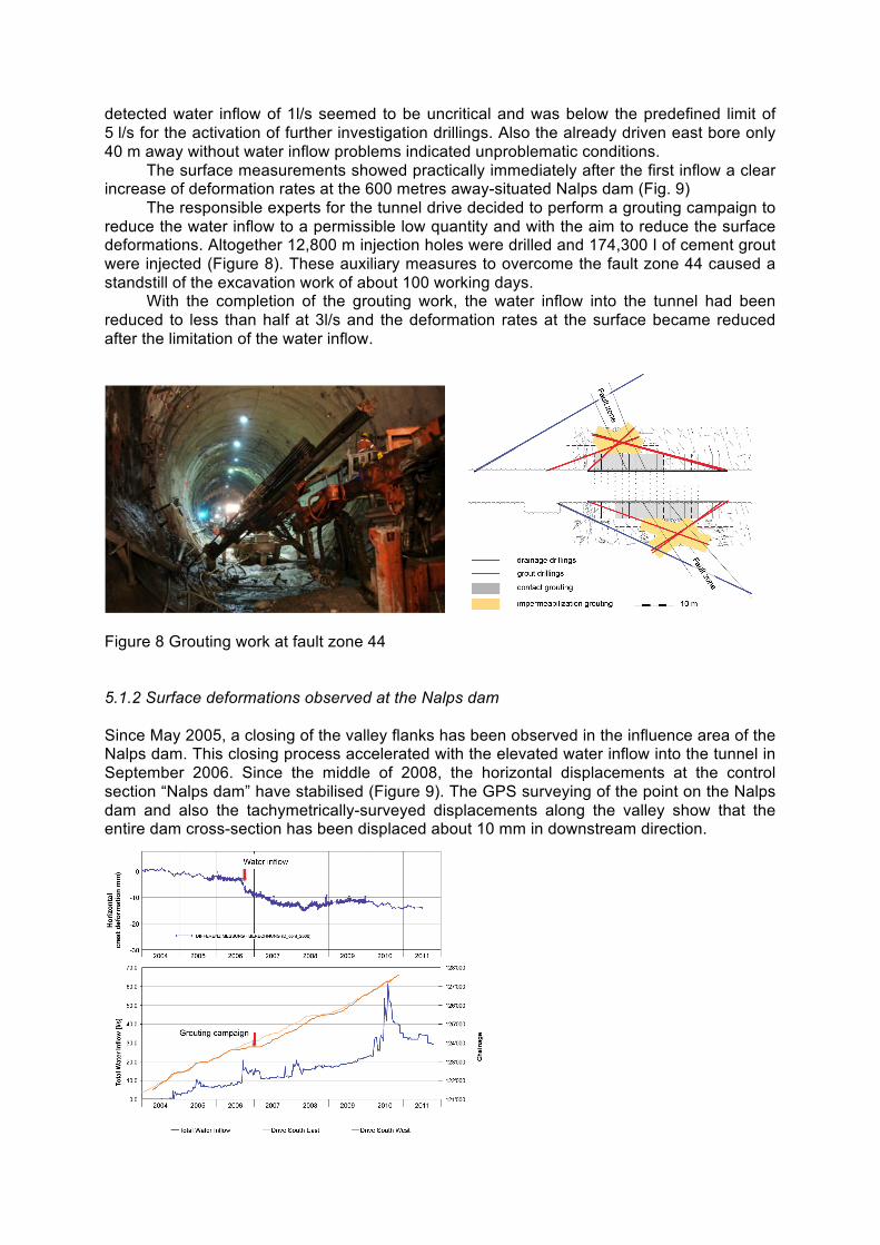
detected water inflow of 1l/s seemed to be uncritical and was below the predefined limit of 5 l/s for the activation of further investigation drillings. Also the already driven east bore only 40 m away without water inflow problems indicated unproblematic conditions.
The surface measurements showed practically immediately after the first inflow a clear increase of deformation rates at the 600 metres away-situated Nalps dam (Fig. 9)
The responsible experts for the tunnel drive decided to perform a grouting campaign to reduce the water inflow to a permissible low quantity and with the aim to reduce the surface deformations. Altogether 12,800 m injection holes were drilled and 174,300 I of cement grout were injected (Figure 8). These auxiliary measures to overcome the fault zone 44 caused a standstill of the excavation work of about 100 working days.
With the completion of the grouting work, the water inflow into the tunnel had been reduced to less than half at 3l/s and the deformation rates at the surface became reduced after the limitation of the water inflow.
Figure 8 Grouting work at fault zone 44 5.1.2 Surface deformations observed at the Nalps dam Since May 2005, a closing of the valley flanks has been observed in the influence area of the Nalps dam. This closing process accelerated with the elevated water inflow into the tunnel in September 2006. Since the middle of 2008, the horizontal displacements at the control section “Nalps dam” have stabilised (Figure 9). The GPS surveying of the point on the Nalps dam and also the tachymetrically-surveyed displacements along the valley show that the entire dam cross-section has been displaced about 10 mm in downstream direction.
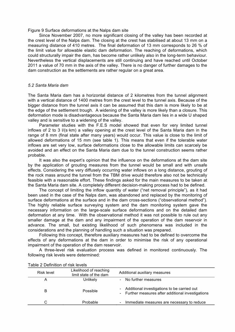
Figure 9 Surface deformations at the Nalps dam site Since November 2007, no more significant closing of the valley has been recorded at
the crest level of the Nalps dam. The closing at the crest has stabilised at about 13 mm on a measuring distance of 410 metres. The final deformation of 13 mm corresponds to 26 % of the limit value for allowable elastic dam deformation. The reaching of deformations, which could structurally impair the dam, has become rather unlikely also in the long-term behaviour. Nevertheless the vertical displacements are still continuing and have reached until October 2011 a value of 70 mm in the axis of the valley. There is no danger of further damages to the dam construction as the settlements are rather regular on a great area. 5.2 Santa Maria dam The Santa Maria dam has a horizontal distance of 2 kilometres from the tunnel alignment with a vertical distance of 1400 metres from the crest level to the tunnel axis. Because of the bigger distance from the tunnel axis it can be assumed that this dam is more likely to be at the edge of the settlement trough. A widening of the valley is more likely than a closure. This deformation mode is disadvantageous because the Santa Maria dam lies in a wide U shaped valley and is sensitive to a widening of the valley.
Parameter studies with the F.E.S model showed that even for very limited tunnel inflows of 2 to 3 l/(s·km) a valley opening at the crest level of the Santa Maria dam in the range of 8 mm (final state after many years) would occur. This value is close to the limit of allowed deformations of 15 mm (see table 1). This means that even if the tolerable water inflows are set very low, surface deformations close to the allowable limits can scarcely be avoided and an effect on the Santa Maria dam due to the tunnel construction seems rather probable.
It was also the expert’s opinion that the influence on the deformations at the dam site by the application of grouting measures from the tunnel would be small and with unsafe effects. Considering the very diffusely occurring water inflows on a long distance, grouting of the rock mass around the tunnel from the TBM drive would therefore also not be technically feasible with a reasonable effort. These findings asked for the main measures to be taken at the Santa Maria dam site. A completely different decision-making process had to be defined.
The concept of limiting the inflow quantity of water (“net removal principle”), as it had been used in the case of the Nalps dam, was abandoned and replaced by the monitoring of surface deformations at the surface and in the dam cross-sections (“observational method”). The highly reliable surface surveying system and the dam monitoring system gave the necessary information on the large-scale surface deformations and on the detailed dam deformation at any time. With the observational method it was not possible to rule out any smaller damage at the dam and any impairment of the operation of the dam reservoir in advance. The small, but existing likelihood of such phenomena was included in the considerations and the planning of handling such a situation was prepared.
Following this concept, therefore auxiliary measures had to be defined to overcome the effects of any deformations at the dam in order to minimise the risk of any operational impairment of the operation of the dam reservoir.
A three-level risk evaluation process was defined in monitored continuously. The following risk levels were determined:
Table 2 Definition of risk levels
Risk level Likelihood of reaching limit state of the dam Additional auxiliary measures
A Unlikely - No further measures
B Possible
- Additional investigations to be carried out - Further measures after additional investigations
C Probable - Immediate measures are necessary to reduce
any probable damage Any information about the dam behaviour, such as results from the inverted plumb
lines, from the joint-meters, from extensometers, from the geodetic survey system etc. will be observed. The criterion to determine the risk level is the deformation velocity of the most critical observation. The time to reach the limit value of the most critical observations is estimated, based on the assumption of a linear continuation of the deformations. If the deformation velocity indicates the reaching of the limit value within a time of more than 48 months, the likelihood is defined as unlikely corresponding to risk level A. In the case of 3 to 48 months the likelihood is defined as possible corresponding to level B. Below a time of 3 months the likelihood is defined as probable, corresponding to level C, which asks for immediate reaction.
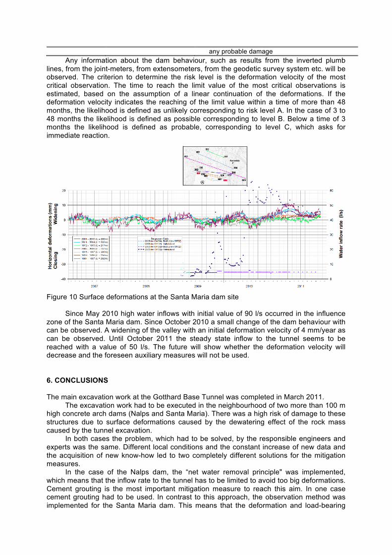
Figure 10 Surface deformations at the Santa Maria dam site
Since May 2010 high water inflows with initial value of 90 l/s occurred in the influence zone of the Santa Maria dam. Since October 2010 a small change of the dam behaviour with can be observed. A widening of the valley with an initial deformation velocity of 4 mm/year as can be observed. Until October 2011 the steady state inflow to the tunnel seems to be reached with a value of 50 l/s. The future will show whether the deformation velocity will decrease and the foreseen auxiliary measures will not be used. 6. CONCLUSIONS The main excavation work at the Gotthard Base Tunnel was completed in March 2011.
The excavation work had to be executed in the neighbourhood of two more than 100 m high concrete arch dams (Nalps and Santa Maria). There was a high risk of damage to these structures due to surface deformations caused by the dewatering effect of the rock mass caused by the tunnel excavation.
In both cases the problem, which had to be solved, by the responsible engineers and experts was the same. Different local conditions and the constant increase of new data and the acquisition of new know-how led to two completely different solutions for the mitigation measures.
In the case of the Nalps dam, the “net water removal principle" was implemented, which means that the inflow rate to the tunnel has to be limited to avoid too big deformations. Cement grouting is the most important mitigation measure to reach this aim. In one case cement grouting had to be used. In contrast to this approach, the observation method was implemented for the Santa Maria dam. This means that the deformation and load-bearing
behaviour of the dam itself are decisive for the measures. The measures will be carried out to the dam structure itself. The changeover to this concept was only possible due to the good collaboration between the experts working for the owner of the Gotthard Base tunnel and the dam operators and thanks to the participation of the responsible authorities.
The experience gained shows once more that there are no simple standard solutions for problems at the limits of current scientific knowledge, but rather that solutions have to be worked out among all parties for the particular case.
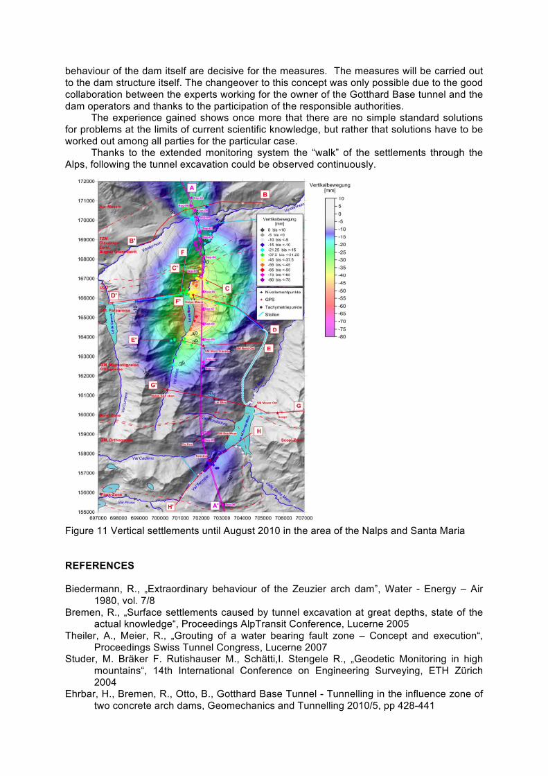
Thanks to the extended monitoring system the “walk” of the settlements through the Alps, following the tunnel excavation could be observed continuously.
Figure 11 Vertical settlements until August 2010 in the area of the Nalps and Santa Maria REFERENCES Biedermann, R., „Extraordinary behaviour of the Zeuzier arch dam”, Water - Energy – Air
1980, vol. 7/8 Bremen, R., „Surface settlements caused by tunnel excavation at great depths, state of the
actual knowledge“, Proceedings AlpTransit Conference, Lucerne 2005 Theiler, A., Meier, R., „Grouting of a water bearing fault zone – Concept and execution“,
Proceedings Swiss Tunnel Congress, Lucerne 2007 Studer, M. Bräker F. Rutishauser M., Schätti,I. Stengele R., „Geodetic Monitoring in high
mountains“, 14th International Conference on Engineering Surveying, ETH Zürich 2004
Ehrbar, H., Bremen, R., Otto, B., Gotthard Base Tunnel - Tunnelling in the influence zone of two concrete arch dams, Geomechanics and Tunnelling 2010/5, pp 428-441