Embed Size (px)
Citation preview
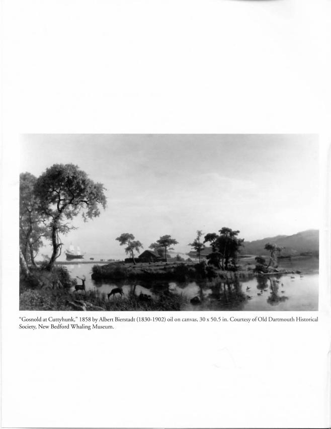
"Gosnold at Cutryhunk," 1858 by AJbert Bierstadr (1830-1902) oil on canvas, 30 x 50.5 in. Courtesy of Old Dartmourh Historical ociery, New Bedford Whaling Museum.
Bartholomew Gosnold's 1602 Voyage to Cape Cod In Verrazzano's Wake
by James W Mavor, Jr.
Preface
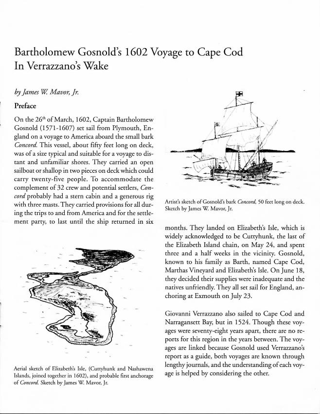
On the 26,h of March, 1602, Captain Bartholomew Gosnold (1571-1607) set sail from Plymouth, England on a voyage to America aboard the small bark Concord This vessel, about fifty feet long on deck, was of a size typical and suitable for a voyage to distant and unfamiliar shores. They carried an open sailboat or shallop in two pieces on deck which could carry twenty-five people. To accommodate the complement of 32 crew and potential settlers, Con
cord probably had a stern cabin and a generous rig with three masts. They carried provisions for all during the trips to and from America and for the settlement party, to last until the ship returned in six
Aerial sketch of ELizaberh's Isle, (Cuttyhunk and Nashawena Islands, joined together in 1602), and probable nrSt anchorage of Concord. Sketch by James W. Mavor, Jr.
~ J. .. " I~ji ~ /
. . . __ , I
Artist's sketch of Gosnold's bark Concord. 50 feet long on deck. Sketch by James W. Mavor, Jr.
months. They landed on Elizabeth's Isle, which is widely acknowledged to be Cuttyhunk, the last of the Elizabeth Island chain, on May 24, and spent three and a half weeks in the vicinity. Gosnold, known to his family as Barth, named Cape Cod, Marthas Vineyard and Elizabeth's Isle. On June 18, they decided their supplies were inadequate and the natives unfriendly. They all set sail for England, anchoring at Exmouth on July 23.
Giovanni Verrazzano also sailed to Cape Cod and Narragansett Bay, but in 1524. Though these voyages were seventy-eight years apart, there are no reports for this region in the years between. The voyages are linked because Gosnold used Verrazzano's report as a guide, both voyages are known through lengthy journals, and the understanding of each voyage is helped by considering the other.
Commemorations
This year, Cape Cod and the islands commemorates the 400,h anniversary of Gosnold's voyage. As part of this event, an exhibit at the Woods Hole Historical Museum presents the voyage in maps, models and text in the context of early voyages to America and the maritime history of Woods Hole. (Museum hours are listed in the back of Spritsail.)
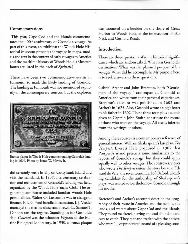
There have been two commemorative events in Falmouth to mark the likely landing of Gosnold. The landing at Falmouth was not mentioned explicitly in the contemporary sources, but the explorers
Bronze plaque in Woods Hole commemorating Gosnold's landing in 1602. Photo by James W. Mavor, Jr.
did certainly settle briefly on Cuttyhunk Island and visit the mainland. In 1907, a tercentenary celebration and reenactmen t of Gosnold's landing was held, organized by the Woods Hole Yacht Club. The organizing committee included familiar Woods Hole personalities. Walter O. Luscombe was in charge of finance. F. L. Gifford handled decoration. J. J. Veeder managed the marine show and fireworks. Samuel T. Cahoon ran the regatta. Standing in for Gosnold's ship Concord was the schooner Vigilant of the Marine Biological Laboratory. In 1930, a bronze plaque
4
was mounted on a boulder on the shore of Great Harbor in Woods Hole, at the intersection of Bar Neck and Gosnold Roads.
Introduction
There are three questions of some historical significance which are seldom asked. What was Gosnold's destination? What was the planned purpose of his voyage? What did he accomplish? My purpose here is to seek answers to these questions.
Gabriel Archer and John Brereton, both "Gentlemen of the voyage," accompanied Gosnold to
America and wrote from their personal experiences. Brereton's accoun t was published in 1602 and Archer's in 1625. Also, Gosnold wrote a single letter to his father in 1602. These three texts plus a sketch given to Captain John Smith constitute the record of those who were on the voyage. All else is inferred from the writings of others.
Among these sources is a contemporary reference of general interest, William Shakespeare's last play, The Tempest. Everett Hale proposed in 1902 that Prospero's island presents some similarities to the reports of Gosnold's voyage, but they could apply equally well to other voyages. The controversy over who wrote The Tempest enters the story because Edward de Vere, the seventeenth Earl of Oxford, a leading candidate for the authorship of Shakespeare's plays, was related to Bartholomew Gosnold through his mother.
Brereton's and Archer's accounts describe the geography of their route in America and the people, the lands, and waters about Cape Cod and the islands. They found mackerel, herring and cod abundant and easy to catch. They met and traded with the natives, who were " ... of proper stature and of a pleasing coun-
tenance." Brereton wrote that the people were "exceeding courteous, gentle of disposition ... excelling all others that we have seen ... quicke-eyed and stedfast in their looks and fearelesse ... strong, healthful and very witty." They found the land full of oak, beech, cedar, heartbent, cherry, sassa-
5
Saylers, twelve purposing upon the discovery to returne with the ship for England, the rest remayne there for population." The glowing reports by Brereton and Archer remind one of real estate agents promoting settlement in a newly developed area.
Their reader can reasonably interpret this to be an objective of the voyage. Also, the voyagers took back a valuable cargo of sassafras roots, used as a medicine, and cedar logs for building, but these results do not seem to justifY the voyage.
fras, ash, witch hazel, elm, holly, and walnut trees. They found fruit trees with fruit bigger than those in England. There were "many springs of excellent sweet water." They saw "cranes, hernshawes, Bitters, Geese, Mallards, Teales and other fowles in great plenty." They found "many huge bones and ribbes of whales ... [and] stones for building." The explorers observed that their strength and health were renewed and increased by the climate. Unfortunately, four days after landing, Gosnold himself casually stole a native canoe. Later there was petty thievery by some natives and increasing distrust of the foreigners.
No one on the voyage wrote much about the questions of Gosnold's destination and pur
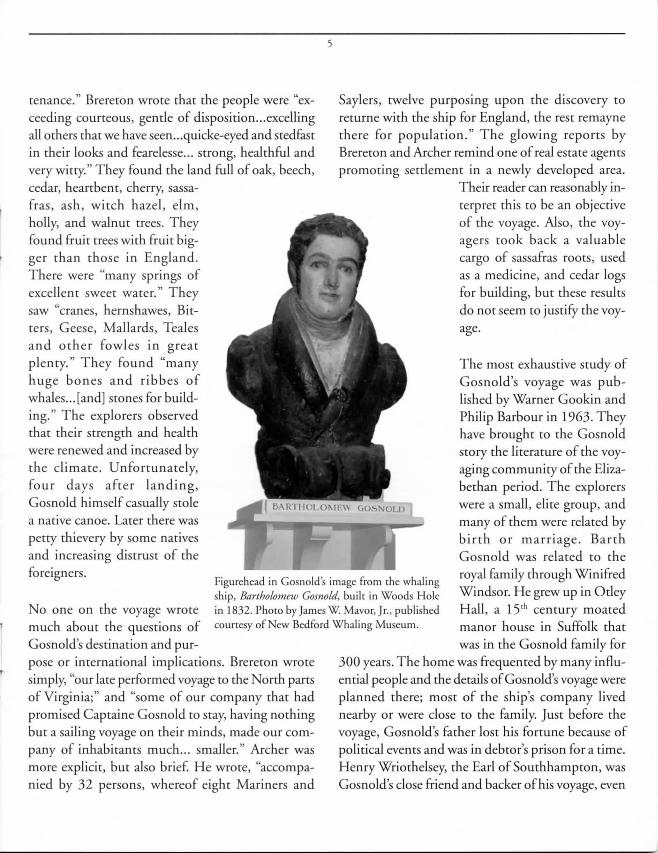
Figurehead in Gosnold 's image from [he whaling ship, Bartholomew Gosnold, built in Woods Hole in 1832. Phoro by James W Mavor, Jr. , published courtesy of New Bedford Whaling Museum.
The most exhaustive study of Gosnold's voyage was published by Warner Gookin and Philip Barbour in 1963. They have brought to the Gosnold story the literature of the voyaging community of the Elizabethan period. The explorers were a small, elite group, and many of them were related by birth or marriage. Barth Gosnold was related to the royal family through Winifred Windsor. He grew up in Otley Hall, a 15 th century moated manor house in Suffolk that
pose or international implications. Brereton wrote simply, "our late performed voyage to the North parts of Virginia;" and "some of our company that had promised Captaine Gosnold to stay, having nothing but a sailing voyage on their minds, made our company of inhabitants much ... smal ler." Archer was more explicit, but also brief. He wrote, "accompanied by 32 persons, whereof eight Mariners and
was in the Gosnold family for 300 years. The home was frequented by many influential people and the details of Gosnold's voyage were planned there; most of the ship's company lived nearby or were close to the family. Just before the voyage, Gosnold's father lost his fortune because of political events and was in debtor's prison for a time. Henry Wriothelsey, the Earl of Southhampton, was Gosnold's close friend and backer of his voyage, even

while outhampron was in the Tower of London. Southampron was condemned for being a co-conspiraror with Robert Devereux, Earl of Essex, in an armed rebellion against the queen. E ex was beheaded in 1601, but Southampron was reinstated by James I after Elizabeth died in 1603. There was a time in 1601 when it seemed the voyage would never take place.
What, then, was behind the voyage? How was it planned and what did English leaders think about it? On these subjects, trus article attempts ro go beyond the details of the observations of Brereron and Archer, the scope of the museum exhibit, and the views of other modern writers. The voyage involved many hisrorical figures in addition ro those who made the voyage itself, and appears ro have had more international significance than is generally acknowledged. Some of these figures now become our focus.
ir Walter Raleigh (1552-1618), was a power behind the scenes with respect to explorations in America. He had a patent from Queen Elizabeth for exploration in America in 1578, the first since John Cabot's patent in 1496. He was enthusiastic about English settlement in America and aade in furs, skins and other commodities. He also introduced robacco ro England. He is known for backing the 1584-1587 attempt at settling Roanoke Island in Virginia. Since the project failed and many people lost their lives, Raleigh's reputation suffered. However, in 1590, he was back in the good graces of tile Queen and acquired her patent for settlement and exploitation in the new world. During Gosnold's voyage, Lord Henry Howard conspired with James VI, King of Scotland, ro frame Raleigh, the Queen's favorite. When Gosnold returned from his voyage, his valuable cargo was impounded as the result of an argument between Raleigh and Gosnold's backers, who were the Earl of South amp ron and Thomas Smythe.
6
Engraved pomair of Giovanni da Verrazzano (I 485- 1628) , by Allegrini 1767. Phoro is reproduced by perm is ion of [he Pierpont-Morgan Library, ew York.
It concerned whether or not Raleigh, as the operating patent holder, gave permission for Go nold 's voyage. It is not clear who received the money, bur shortly after Queen Elizabeth's death in March, 1603, Raleigh was arrested on the orders of the new king of England, James I, formerly James VI ofScorland, and condemned ro the rower.
Richard Hakluyr the younger (1552-1616) was an influential figure in late Elizabethan England. He was a preacher, graduate of Christchurch in Oxford, and contemporary of Shakespeare and Queen Eliza-

beth I. With the help of his older cousin, M. Richard Hakluyt, he collected, edited and published the reports of the worldwide voyages that created the British empire and brought them to the attention of the 16'h century world. Hakluyr the younger's great work, published in 1589 and 1600, went to twelve volumes. Hakluyt did not participate in any of the voyages, nor did he ever go to America, but he inspired and was a principal planner of many, including Gosnold' voyage of 1602.
Hakluyr did not include Gosnold's voyage in his published work simply because the voyage occurred after his publication. Hakluyr is, however, acknowledged to have edited the reports, and participated in the planning. Gosnold's voyage may have been intended to have far reaching effects in the settlement of America, introduction of trade with the English and in the power struggle between England and Spain. The voyage may not have been intended to
include Cape Cod at all.
If one broadens the scope of the investigation, there is much to be found in the records of Queen Elizabeth and powerful sixteenth century European families. These records describe a very complicated chain of events which may have led to the Gosnold voyage in 1602, the last year of Queen Elizabeth's life.
The English were latecomers to the exploration and settlement of North America. Except for John Cabot, in 1498, they ignored America for seventy-five years. Gosnold did have available to him the accounts of the French, Portuguese and Spanish explorers and the maps of their discoveries. Most notably, Giovanni da Verrazzano visited Cape Cod and Narragansett Bay in 1524 and left a report and maps.
Giovanni da Verrazzano sailed from Dieppe in 1524 under the sponsorship of the king of France to dis-
7
cover the northwest passage to the far east. His shjp was La Dauphine, a 100 ton armed vessel of the French navy, 65 feet long on deck with a crew of 50 and well equipped for the eight month voyage. Verrazzano's brother Girolamo made the most accurate map of New England known until the seventeenth century. HistOrians agree that Verrazzano spent twO weeks in Narragansett Bay, mostly in ewPOrt, Rhode Island. Verrazzano called this place Refugio and came to know and respect the natives. English navigators knew of the Verrazzano voyage and map, thanks to Richard Hakluyr. The map was suppressed in Spain because France was not a party to the Treaty ofTordesillas in 1494 which portioned the "undiscovered" or 'heathen" world between Spain and Portugal.
Historian Boies Penrose wrote In 1952 that Verrazzano's report to King Francis I was the most
Arrist's sketch of a ship after [hat shown on Girolamo Verrazzano's 1529 chart. The original chart is located in rhe Vatican Museum, Rome. The vessel is believed to be Verrazzano's ship Ln Dauphine in mid-ocean . ketch by James W. Mavor, Jr.

8
setts and Rhode Island. Most
Artist's sketch of John Speed's 1627 map of Cape Cod, one of the first maps to show the shoals about Cape Cod in detail. Sketch by James W Mavor, Jr.
maps of the period, including this one, were pretty inaccurate, but some like that of John Speed in 1627 were very good. In Wood's map, present-day Newport, Rhode Island, is named Old Plymouth and the Pilgrim settlement on Cape Cod Bay is named New Plymouth, implying that Newport, Verrazzano's Refugio, was a prior location for Plymouth. No explanation has been discovered for these entries. Could not Newport have been Gosnold's destination and a suitable place for a winter trading post? He had set sail from Plymouth , England, and
accurate and the most valuable of all the early coastal voyages that have come down to us. His first landfall was in North Carolina, just north of the northernmost Spanish settlement. From there, Verrazzano sailed north along the coast, passing Newfoundland on the homeward voyage. He passed a triangular island near Newport that may have been either Block Island or Marthas Vineyard. He put it on his map and named it Luisa or Aloysia, after the King's mother. He stopped at Newport in Narragansett Bay for two weeks and called the place Refugio. He sailed around Cape Cod, which he named Cape de la Basse. Unlike most explorers of the time, he was well equipped, confident and knew the natives more intimately than did Gosnold. When Hakluyt started collecting reports of voyages about 1580, he included Verrazzano's report in his works. As will be shown later, Bartholomew Gosnold did read his report, knew his map, and was guided in his voyage by them.
In his 1634 book, New England's Prospect, William Wood published a map of southeastern Massachu-
Newport, Rhode Island was clearly a known and desirable destination. Giovanni da Verrazzano's 1524 report had conveniently provided Gosnold with a description and sailing directions and stated that the natives were friendly.
Planning the Voyage
The story of Gosnold's voyage begins with an anonymous discourse in Queen Elizabeth's state papers of November 6, 1577. It was a secret plan to "weaken the power of Spain by destroying its vessels found fishing and trading in the waters of the new world. In order that the queen could not be held responsible, it was suggested that a patent be issued for establishing colonies in the latest discovered countries in the North or elsewhere." The author's name has been obliterated but it is believed to be that of Sir Humphrey Gilbert, who on June 11, 1578, received a patent from Queen Elizabeth to claim North America in her name and license for him and his heirs and assigns to hold, occupy and manage forever.
In 1583, carrying out this patent, Sir Humphrey Gilbert with a fleet of five ships sailed to Newfoundland, where there was a settlement of fishermen from France and Portugal, and claimed it for the Queen of England. He proclaimed laws and demanded taxes. The residents grudgingly agreed to this arrangement. Only one ship rerurned home to England safely and Gilbert was lost at sea. The only surviving ship captain, Edward Haies, of the Golden Hind, wrote an unusually detailed report of the voyage for Richard Hakluyt, entitled "A True Report. " Haies had also written the prospectus for the voyage, called ''A Treatise," in 1583, which was later republished as an appendix to John Brereton's report of the Gosnold voyage in 1602. This would imply that ''A Treatise" served as the guide for the Gosnold voyage as well as Gilbert's, and also background for Brereton's and Archer's reports.
Haies' "Treatise" of 1584 described the flora and fauna between north latitudes 40 and 44 degrees, the American coastal region known as Norumbega, i.e. present New England. His information came from data compiled by Richard Hakluyt prior to 1583. Anthropologist Neal Salisbury wrote, after David Quinn, that Sir Humphrey Gilbert had followed up on his 1578 patent from Queen Elizabeth by sending a ship to Narragansett Bay in 1580, where the crew made contact with the natives. Information about this voyage would have been useful to Gosnold.
9
the Westerne discoveries lately attempted. " It was a part of Hakluyt's campaign to promote settlement of America by the English for economic reasons. However, Hakluyt wrote,
"The planting of two or three strong forts upon some good havens betwen Florida and Cape Breton would be a matter in short space of greater damage as well as to his (King of Spain's) fleet as to his Western Indies."
Hakluyt added that these forts would enable the English to attack vessels of the Spanish fishing fleet on its annual trip to the Newfoundland fishing grounds. This was essentially the same proposal that had been made to the Queen in 1577, probably written by Sir Humphrey Gilbert. In the meantime, Edward Haies, upon his return to England after the ill-fated 1583 voyage, reported to George Peckham, one of the
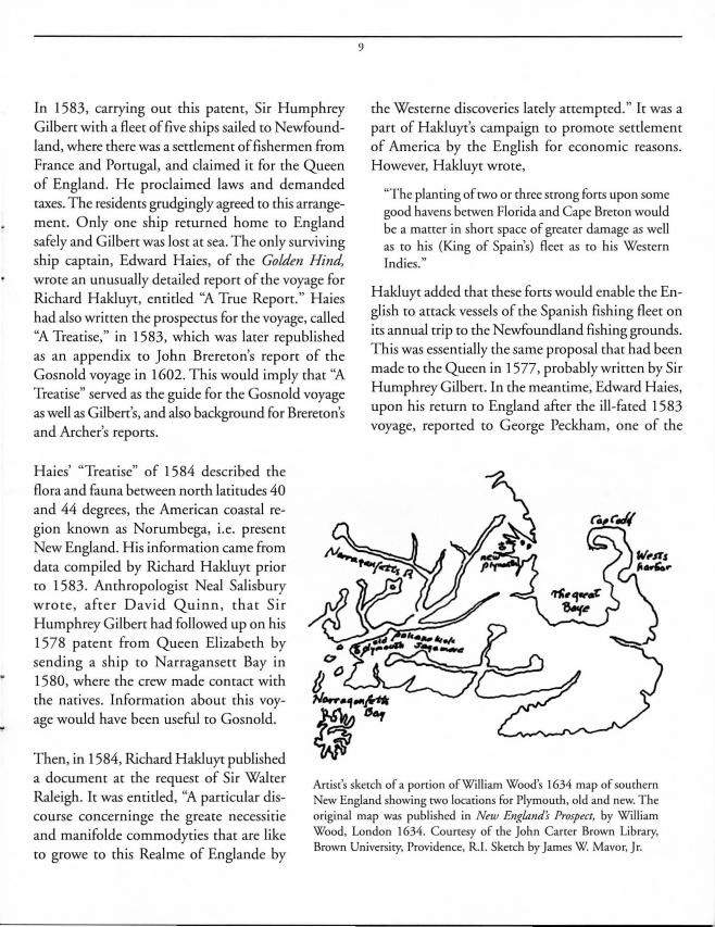
Then, in 1584, Richard Hakluyt published a document at the request of Sir Walter Raleigh. It was entitled, ''A particular discourse concerninge the greate necessitie and manifolde commodyties that are like to growe to this Realme of Englande by
Artisr's skerch of a porrion of William Wood's 1634 map of southern New England showing rwo locations for Plymouth, old and new. T he original map was published in New England's Prospect, by William Wood, London 1634. Courtesy of the John Carrer Brown Library, Brown Universiry, Providence, R.1. Skerch by James W. Mavor, Jr.
"..J'L ; Giu,uni Itamu\Ciu
Guill.umt Lt' T~tu Ili~o lIuml'm brah.m Orl~liUJ
156-1
Gt'nl rdu') ~ I t'n::.lor ornr.li~ dl" Jod"
1~9J
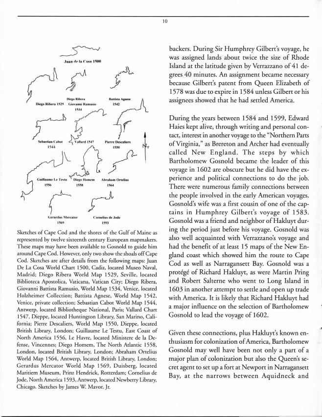
Skerches of Cape Cod and rhe shores of rhe Gulf of Maine as represenred by rwelve sixteenrh cenrury European mapmakers. These maps may have been avai lable [0 Gosnold [0 guide him around Cape Cod. However, only rwo show me shoals off Cape Cod. Skerches are mer derails from me following maps: Juan De La Cosa World Charr 1500, Cadiz, locared Museo Naval, Madrid; Diego Ribera World Map 1529, Seville, locared Biblioreca Apos[Olica, Varicana, Varican City; Diego Ribera, Giovanni Banisra Ramusio, World Map 1534, Venice, locared Holzheimer Collecrion; Bauisra Agnese, World Map 1542, Venice, privare collecrion ; Sebastian CabO[ World Map 1544, Anrwerp, locared Bibliotheque National, Paris; Vallard Chan 1547, Dieppe, locared Huntington Library, San Marino, California; Pierre Descaliers, World Map 1550, Dieppe, locared Brirish Library, London; Guillaume Le Tesru, Easr Coasr of Norm America 1556, Le Havre, locared Minisrere de la Defense, Vincennes; Diego Homem, The North Aclanric 1558, London, locared Brirish Library, London; Abraham Ortelius World Map 1564, Anrwerp, locared British Library, London; Gera rdus Mercator World Map 1569 , Duisberg, located Maritiem Museum, Prinz Hendrick, Rorrerdam; Cornelius de Jode, North America 1593, Anrwerp, locared Newberry Library, Chicago. Skerches by James W. Mavor, Jr.
10
backers. During Sir Humphrey Gilbert's voyage, he was assigned lands about twice the size of Rhode Island at the latitude given by Verrazzano of 41 degrees 40 minutes. An assignment became necessary because Gilbert's patent from Queen Elizabeth of 1578 was due to expire in 1584 unless Gilbert or his assignees showed that he had settled America.
During the years between 1584 and 1599, Edward Haies kept alive, through writing and personal contact, interest in another voyage to the "Northern Parts of Virginia," as Brereton and Archer had eventually called New England. The steps by which Bartholomew Gosnold became the leader of this voyage in 1602 are obscure but he did have the experience and political connections to do the job. There were numerous family connections between the people involved in the early American voyages. Gosnold's wife was a first cousin of one of the captains in Humphrey Gilbert's voyage of 1583. Gosnold was a friend and neighbor of HakJuyt during the period just before his voyage. Gosnold was also well acquainted with Verrazzano's voyage and had the benefit of at least 15 maps of the New England coast which showed him the route to Cape Cod as well as Narragansett Bay. Gosnold was a protege of Richard HakJuyr, as were Martin Pring and Robert Salterne who went to Long Island in 1603 in another attempt to settle and open up trade with America. It is likely that Richard HakJuyr had a major influence on the selection of Bartholomew Gosnold to lead the voyage of 1602.
Given these connections, plus HakJuyr's known enthusiasm for colonization of America, Bartholomew Gosnold may well have been not only a part of a major plan of colonization but also the Queen's secret agent to set up a fort at Newport in Narragansett Bay, at the narrows between Aquidneck and

Jamestown Islands, as suggested by Verrazzano in his 1524 report to the King of France. Verrazzano wrote,
"We turned roward the meridian at the entrance ro the harbor. .. In the middJe of this estuary there is an obstacle ofliving rock, which is suitable for builcling above it a castle or fortress ro defend the port."
In fact , several forts were built at this location on Jamestown Island, Rhode Island, and some ruins remain . It is known that Queen Elizabeth was not particularly interested in settling America, but she saw the defeat of Spain and control of the seas as Britain's destiny. In 1603, Pring and Salterne sailed to New England on another attempt at settlement. On June 18, 1605, Samuel de Champlain charted Plymouth harbor, the same place that was settled by tl1e English Pilgrims in 1620. Champlain sought a suitable place for a permanent French settlement. Gosnold and Archer went to Jamestown, Virginia, where in 1607 they helped to start the first permanent English settlement in America. A settlement in Maine came along in 1609 and eventually the Pilgrims landed in Plymouth, Massachusetts in 1620. Thus both North Virginia (New England) and South Virginia (Mid-Atlantic states) were permanently settled by the Engljsh.
Bartholomew Gosnold's goals included settlement by English colonists in America and exploitation of its natural resources for the benefi t of England. This was to be done by founding a settlement at the Refugio of Verrazzano (Narragansett Bay.) At the same time, he sought to establish a fortified outpost so that the British fleet could harass the Spanish ships rerurning from the Caribbean and those approaching the fishing grounds. Verrazzano had recommended Refugio as a fleet base and specified where a defensive stone fort could be built. The French government had failed to follow up on Verrazzano's recommendation to King Francis I.
II
The Voyage
To explain the extent to which the goals ofGosnold's voyage were real ized, we must examine certain critical points in Brereton's and Archer's relations. Firs t, there is the question of where Gosnold went. When Gosnold and his companions sai led down the coast of America after making landfall in Maine, they came to Savage Rock, referred to by both Archer and Brereton. Archer's account is in the form of a daily journal of principal events. He wrote only from his own experience. The Rev. Brereto n wrote in a more flowery fashjon, and expanded on Archer's journal. He embellished the facts and wrote of experiences in which Archer did not participate. Both men were close associates of Gosnold during the voyage.
Model of Go nold's bark Concord, built by Alan Lunn. Phoro by James W. Mavor, J r.

12
Brereton may have shared with Gosnold knowledge of Queen Elizabeth's secret plan. But when Gosnold went to found the settlement at Jamestown, Virginia, he was accompanied by Archer, who became known as a leader. Both Gosnold and Archer died there of disease and privation . The two journals of the voyage conflict both with each other and each within itself One conflict is the location of Sav-
as a "wild international frontier of cutthroat competition and cultural domination. " The natives had been weakened by plague brought by the foreigners . The idyllic picture of New England painted by Archer and Brereton, and probably experienced by Verrazzano, was no longer the reality.
age Rock, which marked Gosnold's first landfall on May 14, and his first meeting with the natives. Named after the natives, the rock sets the tone for Gosnold's per-ception of them. The place might have been as far south as Cape Ann, Massa-chusetts, or as far north as Cape Neddick, Maine.
T he voyagers were approached by a French or Basque shallop manned by eight Native Americans. They boarded the ship with confidence and their leader was dressed in European clothing. This was no casual encounter; they had experience of this before. Micmac traders who were part of a long-standing and lucrative industry in "furres and skinnes" involved the French settlers to the north as well as natives in New England. This trade-savvy people were a far cry from the docile natives who treated the foreigners like gods, as described by Verrazzano at Refugio. This undoubtedly made Gosnold and his companions suspicious and concerned about their reception elsewhere on the coast. Verrazzano had written that the natives of this northern coast were surly and rude and not like those at Refugio, and this was seventy-eight years later. Anthropologist James Axtell describes the trading scene in the early sixteen hundreds
At Gosnold's first landfall in America, Archer reported thei r meeting with "a Biscay shallop with saile and oares, having eight persons in it." This was the type of well-known and seaworthy ship's workboat developed for the Newfoundland fishery during rwo centuries of experience. Gosnold's shallop, intended for similar service, would be expected to be somewhat similar in design. Archer reported that the shallop carried by Gosnold on the bark Concord was stowed in rwo pieces for the voyage. At Cape Cod, the rwo sections were rowed ashore independently and assembled on the beach. This implies that the rwo parts had matching bulkheads amidships and that the shallop was a double-ender. Based on this and other contemporary sources, the sketches show the assembled shallop under sail with spritsai l and jib, as well as the sections being rowed. This rig was documented by explorers in 1596. The shal lop is estimated to have been 30 feet long and 6 feet 6 inches wide. Sketch by James W. Mavor, Jr.
The discovery of Gosnold's route by a modern investigator is greatly influenced by considerations other than the journals of the Gosnold voyage. They include the observations of other explorers both before and after Gosnold, the usual practice of mariners, modern knowledge of the New England coast, as well as the overt and hidden goals of the voyagers. Verrazzano traveled almost the entire coast from Florida to Newfoundland within sight of land because he sought the passage to the Orient. The usual practice of explorers was to stay as close to shore as was safe. Navigation in shallow water depended primarily on the sounding lead and was laborious and slow. The journals omitted much information on this subject.
Neither Archer or Brereton communicated with the Native Americans they met enough to learn the names of individuals or the names of places. Archer used English names attributed to Gosnold in all cases whereas Brereton used no personal or place names at all, except for one mention of Elizabeth's Isle (Cuttyhunk) . If they had used the traditional names, such as Capawak instead of Marth as Vineyard, their route would probably have been much clearer to people today and showed more respect for the natives. In 1584, the settlers of Roanoke Island in Virginia did not make this mistake; they used the traditional names. However, they were unprepared in other ways, so disappeared from history. Nevertheless, in spite of Gosnold's lack of sensitivity and the decline of native cultures, many of the islands and Cape Cod places retain their native names.
We know that the reports ofVerrazzano, Archer and Brereton were cut and added to, both to hide the location of places of discovery from competing explorers and to prevent critical military and political information from reaching the court of Spain. Gosnold and Hakluyt undoubtedly edited the
13
Gosnold voyage reports. The Spanish ambassador to England, for his part, was interested in the accuracy of maritime reports, so that his reports to Spain may in some cases be more accurate than English sources. He was busily engaged in interpreting and promptly conveying all such intelligence to his superiors. These documents are turning up even today in the Spanish Royal Archives at Simanca, Spain. Nowhere is the falsification of sixteenth century maritime reports more vividly illustrated than in the suppression of the hazards of navigating about Cape Cod. The Mayflower was nearly lost and we don't know the fate of John Cabot, Miguel and Gaspar Corte Real, or the nameless Portuguese, French, English and Spanish fishermen who crossed the Atlantic by the hundreds.
Choices of Route
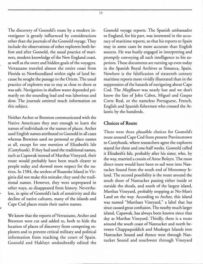
There were three plausible choices for Gosnold's route around Cape Cod from present Provincetown to Cuttyhunk, where researchers agree the explorers stayed for three and one-half weeks. Gosnold called it Elizabeth's Isle, probably after his sister, who, by the way, married a cousin of Anne Boleyn. The most direct route would have been to sail west into Nantucket Sound from the south end of Monomoy Island. The second possibility is the route around the south shore of Nantucket passing either inside or outside the shoals, and south of the largest island, Marthas Vineyard, probably stopping at No-Man's Land on the way. According to Archer, this island was named "Marthaes Vineyard," a label that has since caused great confusion. The nearby much larger island, Capawak, has always been known since that day as Marthas Vineyard. Thirdly, there is a route around the south coast of Nantucket and north between Chappaquiddick and Muskeget Islands into Nantucket Sound and thence west through Nantucket Sound and southwest through Vineyard
.... ---, .... , .... I " , ,
\ \ \
\
14
learned a little of their ways. Their reports of encounters with the shoals are brief and confusing either because they chose to keep their information secret or because they gave the shoals a wide berth. Another documented connection between Gosnold and Verrazzano is to be found in Gosnold's only known written communication on the subject of his voyage, a letter to his father, Anthony Gosnold, of7 Sept. 1602. He revealed that he had read about Verrazzano's voyage. This was six weeks after Gosnold's return from the voyage and before he had returned to his ancestral home at Otley Hall. He wrote,
Map of Cape Cod showing shoals and possible routes of Gosnold around Cape Cod. Sketch by James W. Mavor, Jr.
"But Verrazzano, and others (as I take it, you may read in the Book of Discoveries) do more particularly enrreat of the age of the people in that coast."
Sound to Cuttyhunk, with a stop at present Marthas Vineyard. This route is preferred by researchers Gookin and Barbour. All three routes present problems when compared with the journals of Brereton and Archer.
Rather than tracing the entire route of Gosnold about and through the waters of Cape Cod and the islands, I have chosen to describe only the events of the first two days after Gosnold sighted Cape Cod. My reason is that Archer and Brereton are consistent for this period and they are supported by independent sources. Thereafter, in my opinion, Gosnold's route is hopelessly lost in contradictory and unreliable reports. It is clear only that he sailed around the islands or through Nantucket Sound, arriving at Cuttyhunk on May 24. During the eight days intervening, he surely landed at Marthas Vineyard and Cuttyhunk, and perhaps at No Mans Land, possibly Nantucket, and other Elizabeth Islands. They met Native Americans in two or three places and
A Hilltop View of Cape Cod
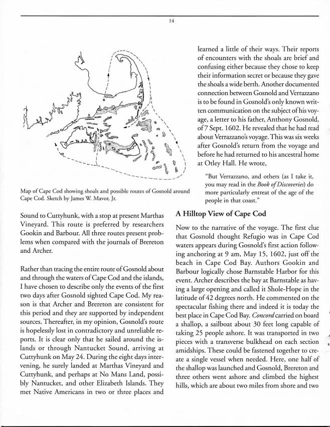
Now to the narrative of the voyage. The first clue that Gosnold thought Refugio was in Cape Cod waters appears during Gosnold's first action following anchoring at 9 am, May 15, 1602, just off the beach in Cape Cod Bay. Authors Gookin and Barbour logically chose Barnstable Harbor for this event. Archer describes the bay at Barnstable as having a large opening and called it Shole-Hope in the latitude of 42 degrees north. He commented on the spectacular fishing there and indeed it is today the best place in Cape Cod Bay. Concord carried on board a shallop, a sailboat about 30 feet long capable of taking 25 people ashore. It was transported in two pieces with a transverse bulkhead on each section amidships. These could be fastened together to create a single vessel when needed. Here, one half of the shallop was launched and Gosnold, Brereton and three others went ashore and climbed the highest hills, which are about two miles from shore and two
hundred feer high. One is Shootflying HiLI and the other Clay Hill, one half mile to the wesr, both ar lari rude 41 degrees 40 min ures, precisely the larirude Verrazzano reponed for Refugio. Climbing a hill to view rhe lay of the land and sea is common practice among adventurers. Except for more disrant hills in Sandwich, these hills are the highesr on the cape and give an unobstructed view of almost the whole of Cape Cod. The landing spot was probably chosen because the hills appeared to meet this criterion. Brereton wrore,
"Wenr ashore, being a white sandie and very bold shore, and marching all the afternoone with our muskets on our necks, on the highest hiU which we
" saw.
The group returned to their ship "tOward evening ... five or six hours" later, according to
Brereton, and found that their shallop had been reassembled with its orher halfby the ship's crew in their absence. While on the hilltop, Brereton observed that "we received this headland [Cape Cod]
15
to be a parcell of the maine, and sundrie Lands lying almost round about it. "
Archer confirmed that the Captain went ashore and the latitude was 42 degrees. But neither Archer nor Brereton mentioned the key information they must have gained from the climb. There was another great body of water, Nantucket Sound, a few miles away in plain sight. There was apparently a wide opening to the open ocean to the southeast. They would have acquired an accurate perception of the shape and size of Cape Cod.
Gookin and Barbour evidently concluded, probably based on a climb up Shootflying Hill , thar Gosnold would have seen the expanse of Nantucket ound, Marthas Vineyard, Great Island in the foreground, Cape Poge and Chappaquiddick Island. They wrote that Gosnold would have seen Vineyard Sound only as "a narrow silver thread" and would not have seen the Elizabeth Islands or Buzzards Bay.
~-- ------
------ --- - -- - """, - ---
View co the sourhwesr from me summir of Clay Hill , Barnsrable, Cape Cod, showing wesrern of warer. Skerch by James W. Mavor. J r.
anrucker Sound as a narrow srrip
To evaluate Archer's, Brereton's, and Gookin's reports, I climbed Clay Hill in Barnstable, near Shootflying Hill but more accessible, on a clear morning in January. I also made an analytical simulation, based on published observed topographic data, of the elevation profiles from the hilltop covering the view all around the compass. From this, I calculated the distances to the visible horizon, water or land, considering the earth's curvature and terrestrial refraction, which varies with the clarity of the atmosphere. The results of the simulation, confirmed by observation, were the following. They differ in part from Gookin and Barbour.
1. Nantucket Sound can be seen from end to end. There appears to be an entrance to the sound from the sea that stretches from Marthas Vineyard to the southeast corner of Cape Cod. The sounds appear as a continuous narrow horizontal strip of water extending from East Chop to the west.
2. Cape Poge on Chappaquiddick Island at 25 feet elevation is at the limit of visibility and unlikely to
have been seen by Gosnold.
3. Vineyard Sound is visible with a sea horizon of 22 miles on a clear day, about as far as Tarpaulin Cove.
4. The Elizabeth Islands are visible as a hilly land mass to the southwest as far as Naushon Island. They appear to be part of the mainland.
5. Buzzards Bay is completely invisible.
6. Wequaquet Pond with its many small islands is visible in the foreground.
7. Monomoy Point, at 22 feet elevation, is at the limit of visibility. Morris Island and the high lands of the outer Cape are visible to Provincetown.
8. Marthas Vineyard appears to be an island, or two
islands, and Gay Head is barely visible.
16
Two entrances to Nantucket Sound from the sea can be seen, at the east and west ends of Marthas Vineyard. Archer wrote later in the narrative that Captain Gosnold had said that they were at one of those entrances he had seen from the hilltop.
Standing on the hilltop with Nantucket Sound stretched out before him, Gosnold could have seen it as Refugio and his subsequent route around Cape Cod probably took this into consideration. He could then have perceived Marthas Vineyard as part of the mainland.
Sailing Around Cape Cod
We do not know for sure whether Gosnold started off around the cape the night of May 15, but there is no mention of further landings or anchorings until the next day. Gosnold, who had just seen what he thought was his goal, would have been unlikely to
delay. It lay just around the corner, or so it seemed. The shallop had been fastened together and was ready for the frequent soundings needed to navigate the shoals that Verrazzano warned against. The moon rose at 1 :30 am on the eastern sea horizon on the morning of May 16, 1602. Verrazzano wrote the following about his voyage from Narragansett Bay (Refugio) and around Cape Cod (c. de la Basse):
'This country (Refugio) is situated on a parallel with Rome at 41 2/3 degrees. The coast of the land runs from west to east. The harbor faces south and is half a league wide; for its entrance it extends for XII leagues in a northerly direction, then widens out to
form a large bay of about XX leagues circumference. In the bay there are five small islands.
Having supplied all our needs, we left the port [Refugio] on the sixth day of May and sailed along the coast, never losing sight of land. We sailed 150 leagues and found the land similar in nature, but somewhat higher."

In the Cellere-Morgan manuscript of Verrazzano's report, the following footnote describes Nantucket Shoals and George's Bank. It appears in what is thought to be Verrazzano's own hand.
"Wimin mis distance we found sandbanks which stretch from me continent fifty leagues out to sea. Over them me water was never less than three feet deep: there is great danger in sailing mere. We crossed over mem wim difficulty and called mem Armellini. "
Verrazzano's report and the maps of his brother and Maggiolo show the coasts and the shoals in a general way. But navigation on shoals such as those about Cape Cod was accomplished using the sounding lead. It told the depth of water and the nature of the bottom and observation told of the color and taste of the water. Interpretation of the bottom sample sticking to the tallow, placed there before lowering, told of sand, soil, mud, silt, stones and even organic matter of different colors and consistencies. This data made up much of the detail in maritime journals, few of which survive. Each ship usually carried two sounding leads, one, as heavy as 100 pounds, for water up to 100 fathoms deep and another smaller and faster in handling for water less than 20 fathoms. From Archer's report earlier in the voyage, we know that he was used to using the heavy sounding lead in deep water and could have navigated the outer edge of Nantucket Shoal. This was done with great skill by experienced seamen.
By the morning of May 16, they were sailing south along the coast, a league or two offshore, according to Archer. He wrote,
"We trended the Coast Soumerly, which was all cham paine and full of grasse, but me Hands somewhat woodie."
17
Brereton wrote,
"From me place [rhe anchorage at Cape Cod Bay, a league off Barnstable Harbor] we sailed round about me headland about all points of the com passe, the shore very bolde ... At length we were come amongst many faire Lands, which we had partly discerned at our first landing, all lying wimin a league or two of one anomer, not above sixe or seven from the maine."
Gosnold would have felt confident enough to set sail late on May 15 and sail around Provincetown and down the coast of Cape Cod at night, for he learned on top of the Barnstable hills that he could eventually find Nantucket Sound. He could navigate a course that would bring him to the eastern end of the large island he saw, now called Marthas Vineyard, because he now knew where it was. At daylight on March 16, he could have reached Monomoy Island and the beginning of Monomoy Shoal, depending upon wind and current. Archer and Brereton are surprisingly brief about the difficult passage around Cape Cod, of which Verrazzano warned. The records never even mention tidal current which controls the progress of sailing craft in these waters. The six miles length of Monomoy Shoals would have discouraged Gosnold from entering Nantucket Sound; he would have wisely stayed to the east and reached the deep water south of Nantucket. Then, he would have had clear sailing to the west. Twelve years later, Gosnold's friend, Captain John Smith, avoided Monomy Shoals in this fashion and wrote about them as "a long and dangerous shoale of sands and rocks ... and a strong current. "
Gosnold and his crew reached Elizabeth's Isle on May 24, built their forr and settled in to three weeks of local exploring and meeting the natives. Relations began smoothly but became strained by the time of
ihe
o I.ui ..
.·rHlrllounM Int-.,. o ~ 100
o 100 200 t:nll"'l1 n .. liral .. ,In
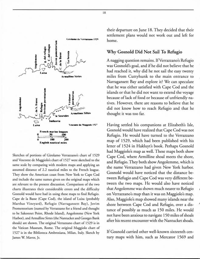
Skerches of portions of Girolamo Verrazzano's chan of 1529
and Vescome de Maggiolo's chan of 1527 were skerched co rhe
same scale by comparing wim modern maps and applying an
assumed disrance of 2.2 nautical miles co me French league.
They show the American coasr from New York co Cape Cod
and include me same names given on me original maps which
are relevanr co me presem discussion. Comparison of me two
chans illustrares rheir considerable errors and rhe di fficulty
Gosnold would have had in using these maps co find Refugio.
Cape de la Basse (Cape Cod), the island of Luisa (probably
Manhas Vineya rd), Refugio (Narraganse[[ Bay), Jovim
Promemorium (named by Verrazzano for a friend and moughr
co be Sakonner Poim, Rhode Island), Angolemme (New York
Harbor), and Armalline Sines (me Nantucker and Georges Bank
shoals) are shown. The original Verrazzano chart of 1529 is in
me Vatican Museum, Rome. The original Maggiolo chart of
1527 is in the Biblioreca Ambrosiana, Milan, Italy. Skerch by
James W. Mavor, J r.
18
their departure on June 18. They decided that their settlement plans would not work out and left for home.
Why Gosnold Did Not Sail To Refugio
A nagging question remains. IfVerrazzano's Refugio was Gosnold's goal, and ifhe did not believe that he had reached it, why did he not sail the easy twenty miles from Cuttyhunk to the main entrance to Narragansett Bay and explore it? We can speculate that he was either satisfied with Cape Cod and the islands or that he did not want to extend the voyage because of lack of food or because of unfriendly natives. However, there are reasons to believe that he did not know how to reach Refugio and that he thought it was too far.
Having settled his companions at Elizabeth's Isle, Gosnold would have realized that Cape Cod was not Refugio. He would have turned to the Verrazzano map of 1529, which had been published with his letter of 1524 in Hakluyr's book. Perhaps Gosnold had Maggiolo's map as well. These maps both show Cape Cod, where Armilline shoal meets the shore, and Refugio. They both show Angolemme, which is the name Verrazzano had given New York harbor. Gosnold would have noticed that the distance between Refugio and Cape Cod was very different between the two maps. He would also have noticed that Angolemme was shown much nearer to Refugio on Verrazzano's map than it was on Maggiolo's map. Also, Maggiolo's map showed many islands near the shore between Cape Cod and Refugio, over a distance of possibly as much as 150 miles. He would not have been anxious to navigate 150 miles of shoals after his recent encounter with the Nantucket shoals.
If Gosnold carried other well-known sixteenth century maps with him, such as Mercator 1569 and
Descalier 1550, he would have confirmed that the distance between Refugio and Cape Cod was shown to be at least a highly exaggerated 200 miles. On the other hand, Vollard 1547 places the two landmarks close together. If this was not enough to discourage him from searching for Refugio, Gosnold could have turned to Verrazzano's report of his 1524 voyage. He had read the Rarnusio version in Hakluyt's
19
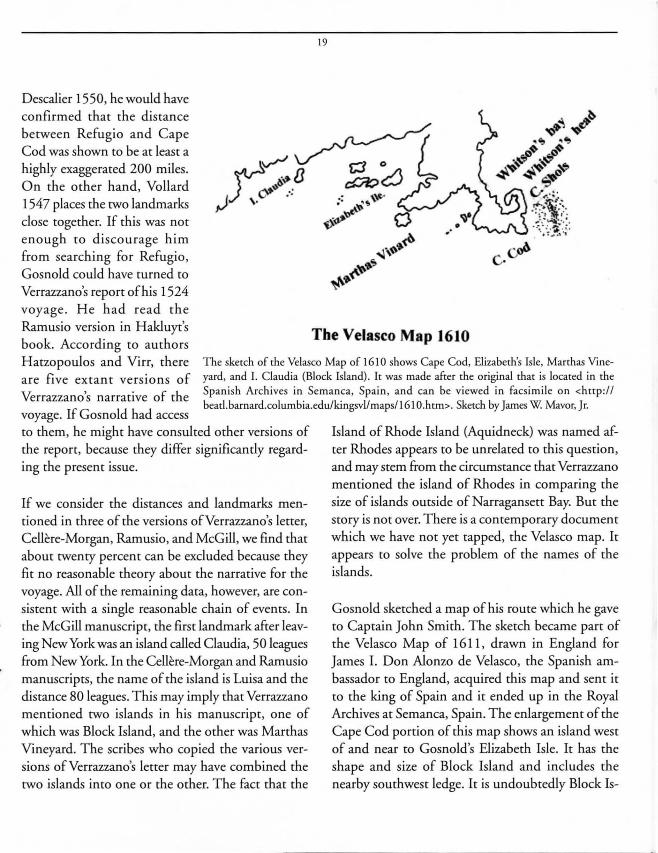
The Velasco Map 1610 book. According to authors Hatzopoulos and Virr, there are five extant versions of Verrazzano's narrative of the voyage. If Gosnold had access
T he sketch of the Velasco Map of 1610 shows Cape Cod, Elizabeth's Isle, Marthas Vineyard, and I. Claudia (Block Island) . It was made after the original that is located in the Spanish Archives in Semanca, Spain , and can be viewed in facsimil e on <http :// beatl .barnard.columbia.edu/kingsvllmaps/1610.htm>. Sketch by James W Mavor, Jr.
to them, he might have consulted other versions of the report, because they differ significantly regarding the present issue.
If we consider the distances and landmarks mentioned in three of the versions ofVerrazzano's letter, Cellere-Morgan, Rarnusio, and McGill, we find that about twenty percent can be excluded because they fit no reasonable theory about the narrative for the voyage. All of the remaining data, however, are consistent with a single reasonable chain of events. In the McGill manuscript, the first landmark after leaving New York was an island called Claudia, 50 leagues from New York. In the Cellere-Morgan and Rarnusio manuscripts, the name of the island is Luisa and the distance 80 leagues. This may imply that Verrazzano mentioned two islands in his manuscript, one of which was Block Island, and the other was Marthas Vineyard. The scribes who copied the various versions ofVerrazzano's letter may have combined the two islands into one or the other. The fact that the
Island of Rhode Island (Aquidneck) was named after Rhodes appears to be unrelated to this question, and may stem from the circumstance that Verrazzano mentioned the island of Rhodes in comparing the size of islands outside of Narragansett Bay. But the story is not over. There is a contemporary document which we have not yet tapped, the Velasco map. It appears to solve the problem of the names of the islands.
Gosnold sketched a map of his route which he gave to Captain John Smith. The sketch became part of the Velasco Map of 1611 , drawn in England for James I. Don Alonzo de Velasco, the Spanish ambassador to England, acquired this map and sent it to the king of Spain and it ended up in the Royal Archives at Semanca, Spain. The enlargement of the Cape Cod portion of this map shows an island west of and near to Gosnold's Elizabeth Isle. It has the shape and size of Block Island and includes the nearby southwest ledge. It is undoubtedly Block Is-
Cod and may have also known Narragansett Bay and had their stories conveyed to Verrazzano.
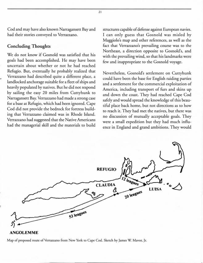
Concluding Thoughts
We do not know if Gosnold was satisfied that his goals had been accomplished. He may have been uncertain about whether or not he had reached Refugio. But, eventually he probably realized that Verrazzano had described quite a different place, a landlocked anchorage suitable for a fleet of ships and heavily populated by natives. But he did not respond by sailing the easy 20 miles from Cuttyhunk to
Narragansett Bay. Verrazzano had made a strong case for a base at Refugio, which had been ignored. Cape Cod did not provide the bedrock for fortress building that Verrazzano claimed was in Rhode Island. Verrazzano had suggested that the Native Americans had the managerial skill and the materials to build
ANGOLEMME
21
structures capable of defense against European navies. I can only guess that Gosnold was misled by Maggiolo's map and other references, as well as the fact that Verrazzano's prevailing course was to the Northeast, a direction opposite to Gosnold's, and with the prevailing wind, so that his landmarks were few and inappropriate to the Gosnold voyage.
Nevertheless, Gosnold's settlement on Cuttyhunk could have been the base for English raiding parties and a settlement for the commercial exploitation of America, including transport of furs and skins up and down the coast. They had reached Cape Cod safely and would spread the knowledge of this beautiful place back home, but not directions as to how to reach it. They had met the natives, but there was no discussion of mutually acceptable goals. They were a small expedition but they had much influence in England and grand ambitions. They would
REFUGIO
Map of proposed route ofVerrazzano from New York to Cape Cod. Sketch by James W. Mavor, Jr.
be followed yearly by other voyagers to New England in increasing numbers. In 1629, 3000 Puritans landed in Salem. In 1607, Gosnold would go on to be principally responsible for starting Jamestown, Virginia, the first permanent English settlement in America. Thus Barth Gosnold was a major figure in unleashing what anthropologist Francis Jennings called the "invasion of America."
It would be many voyages before the settlers realized that they needed to adapt to the new land and to learn from the natives; a self-sufficient European lifesryle in barricaded settlements would not work. It was many years before the notion of an American culture arose that was not solely for the purpose of feeding and otherwise supporting European visions of material and spiritual empire.
We have raised many questions and provided some reasons why they are unanswered. We have also answered the questions raised at the start of this article.
We have shown that deciphering Gosnold's voyage requires deciphering Verrazzano and vice versa. Cosi, cosa!
Literature Cited
Sixteenth and seventeenth century documents
Anonymous, journal of 1596 expedition ofWtlliam Barmu, Rare Books and Manuscriprs Division, New York Public Library, Asror, Lenox and Ti lden Foundation.
Anonymous, "A Discourse How Hior Majesrie May Annoy rhe King of Spayne," Elizaberh , Vol. CXVIII, No. 12, November 6, 1677.
Anonymous, The Vtlasco World Map, c. 16 10. This map was drawn in London fo r King James I, and long losr. Ir was found in rhe 1880s in rhe Spanish Royal Archives in Semanca, Spain, where ir had been raken by the Spanish ambassador ro England, Alonso de Velasco. The Cape Cod portion was based on informarion given by Barrholomew Gosnold ro Caprain John Smith. Ir is more accurare rhan many larer maps and adds new informarion abour both
22
Gosnold's and Verrazzano's voyages. The map is locared in rhe Spanish Royal Archives, Semanca, Spain. A facsimile is on <hnp:/! beatl.barnard.columbia.edu/kingsvllmaps/16 10.htm>.
Archer, Gabriel, "The Relation of Capraine Gosnolds Voyage ro rhe Norrh part of Virginia, begunne the sixe and twentierh of March, Anno 42. Elizabethae 1602. And delivered by Gabriel Archer, a Gentleman of the said voyage." in Purchas, Samuel, Purchas His Pilgrimmes, London, 1625. Also in "Gosnold 's Sertlement at Curryhunk," Old Sourh Leaflets, Vol. V No. 12, New York, xviii, pp. 302-303.
Brereron, John "A Briefe and True Relarion of rhe Discovery of rhe Norrh Parr of Virginia," London, Bishop, 1602. (Published as a lerrer ro Sir Walrer Raleigh three monrhs after rerum from rhe voyage.)
Ganong, W.E, Crucial Maps in the Early Cartography and Place Nomenclature of the Atlantic Coast of Canada, ed. T. E. Laying, Toronto, 1964.
Hakluyr, Richard, Divers Voyages Touching on the Discovery of Americil. London, 1582.
Hakluyr, Richard, The Principal Navigations, Voyages, Traffiques 0- Discoveriesetc. London, 1589, 1598, 1600.
Hakluyr, Richard , "A particular discourse concerninge rhe greare necessirie and manifolde comodyries rhat are like ro growe ro rhis Realme of Englande by rhe Wesrerne discoveries larely anempred, Wrirren In rhe yere 1584 by Richarde Hackl uyr of Oxforde at rhe requesre and direcrion of rhe righre worshipfull Mr. Barkes: and is devided into xxi chapirers, rhe Titles whereof in rhe next leafe." Oxford. 1584.
Haies, Edward, "A True Report: Sir Humphrey Gilbert's Voyage ro Newfoundland ," London, 1583.
Haies, Edward, Treatise, London, 1584.
HatzOpoulos, Dionysius and Richard Virr, "The Voyage of Giovanni da Verrazzano, A Newly Discovered Manuscripr," Fontana V, 1992.
Kupperman, Karen Ordahl, Captaill john Smith, University of North Carolina, Chapel Hill, 1988.
Maggiolo, Vesconte de, World Chart, 1627. The map is located at rhe Biblioreca Ambrosiana, Milan, Iraly. Ir can be viewed in facsimile on <hnp:llwww.henry-davis.com/MAPS/Ren/Ren I/340mono.hunl >.
Raleigh , Sir Walrer, "Lener ro Sir Robert Cecil, Weymourh, England, dated 2 1 August 1602, concerning rhe impounding of Gosnold's cargo of sassafras," in W.E Gookin and p.L. BarboUI, 1963.
Ramusio, M. Gio. Bartista, Delle Navigatiolle et Viaggi, Vol. I, Venitia, 1565.
Shifflen, Crandall, "Masrer Barrholomew Gosnold's Lener ro his farher, rouching his fi rst voyage to Virginia," Virtualjammowll Project, Firrt HandAccounu Of Virginia, University of Virginia, 2000. Also, Gosnold, Bartholomew, A lener ro Anthony Gosnold Esq., (Bartholomew's farher), Grundisburgh Manor, Grundisburgh, Suffolk, from Barrholomew Gosnold Esq., Middle Temple, London, 7 Sept. 1602.
Verrazzano. Girolamo. World Chart. 1529. The map is located in The Vatican Museum. Rome. Italy. It can be viewed in facsimile at <http://www.herirage.nf.calexploration/verrazzano.html> .
Verrazzano. Giovanni da. Lm~r to the King of France. 1524 . Four complete and twO incomplete contemporary manuscripts are exrant. The Cellere- Morgan manuscript was published in Wroth . Lawrence. Th~ Voyages of Giovanni ~rrazzano. Yale. New Haven. 197 1. and the McGill manuscript by D. Hatzopoulos and R. Virr in Fontana V. 1992. T he Cellere-Morgan manuscript is located at the Morgan Library. New York. The McGill and Rarnusio manuscripts are located at the Department of rare Books and Special Collections. McGill University Libraries. Montreal. Canada.
Wood. William. N~w Engumds Prospm. London 1634. reprinted. Ed.: Alden T. Vaughan. University of Massachusetts Press. Amherst. MassachusettS. 1977.
Modern Sources
Axtell. James. &yond 1492, Oxford. New York. 1992.
Baker. William A.. Sloops and Shallops, Barre Press. Barre. Massachusetts. 1966.
Blacker. Irwin R .• ed. Hakluyts Imyag~s. Th~ Principal Navigations, Imyag~s, Traffiqtm and Discovm~s oftlJ~ English Nation, ~tc. Viking Press. New York. 1965.
Eliot, C.W .• ed. Voyag~s and Trav~ls: Ancimt and Moekrn. with introductions, now and illustrations, New York; P.E Collier and son, (c. 1910) The Harvard Classics. Vol XXXlII.
Gookin . Warner E. ed. Philip L. Barbour. Bartholom= Gosno/d, Archon Books. Hamden. Connecticut and London. 1963.
Jennings. Francis. Th~ Invasion ofAmaica: Indians. Colonialism, and th~ Cam ofConqtmt, Norton, New York, 1975.
Landsuom, Bjorn. Th~ Ship, an Illustrat~d History. Doubleday & Company. Garden City. New York. 1961.
Lehane. Brendan. Th~ Northw~st Passag~, lime-Life Books. Alexandria. Virginia, 1981.
Mavor. James W .• Jr. "Voyagers and Settlers." in Woods Hou R~focti01lS, Mary Lou Smith. ed .• Woods Hole Historical Collection. Woods Hole. MassachusettS. 1983.
23
Morison, Samuel Eliot. Th~ Europ~an Discovery of Am~rica, Th~ North~rn Voyag~s. Oxford. New York. 1971 - 1974.
Nebenzahl. Kenneth. Maps from th~ Ag~ of Discov~ry. limes Press. London. 1964.
Penrose, Boies. Trav~l and Discovery in the Rmaissance, 1420-1620, Cambridge. England. 1952.
Quinn. David B. ed., Th~ Voyag~s and Colonizing Enurprim of Sir Humphrey Gilbert, 2 vol. HakJuyr Society Press, London. 1940.
Salisbury. Neal. Manitou and Providmce, Oxford. New York. 1982.
Silliman. Horace E. "T he Newport Tower: Sir Humphrey Proposes 'Annoying the King of Spayne,' .. New England Anriquiries Research Association Newsletter. Vol. 4. No.2. 1969.
Taylor. E.G. R .• Th~ Havm Finding Art, Elsevier. New York. 197 1.
Volljns, Arthur. LmmandM~orialsofState, London. 1746. pp. 2 11 -326.
Wilson. Harold c.. Thou Pearly Isles, Gosnold Society of Cape Cod. Falmouth. MassachusettS. 1976.
Wroth. Lawrence. Th~ Imyag~s of~rrazzano. Yale. New Haven. Connecticut. 197 1.
Biography
James Watt Mavor, Jr. came ro Woods Hole as an infanr in 1923 when his father, an MBL invesrigaror, and Sranley Eldridge were building the Mavors' summer cottage. After a career in college reaching Jim moved ro Woods Hole year round with his wife. Mary, and their th.ree small children. Jim joined WHO! fulltime in 1961 to srarr a manned submersible program which produced Alvin. Since rhen his careers have included ship design, more college reaching and research, oceanographic engineering and, for the pasr 37 years, developing interesr in interdisciplinary srudy of pasr cultures as an independent researcher and wrirer. He has published cwo books, Vcryage To Atlantis, 1969, 1990, and Manitou, The Sacred Landscape of New England's Native Civilization, 1989. He has also contributed to W00ds Hole Reflections, the Book of Falmouth and Spritsail.