Embed Size (px)
Citation preview
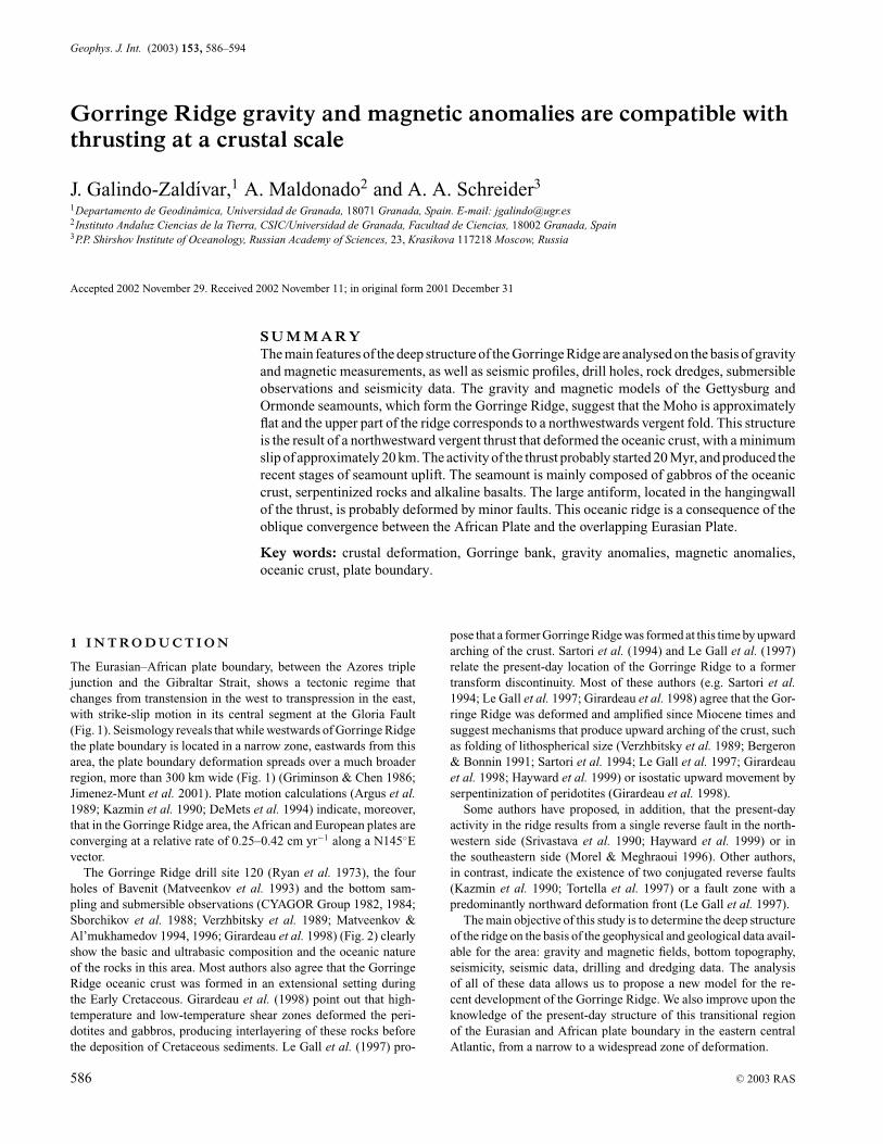
Geophys. J. Int. (2003) 153, 586–594
Gorringe Ridge gravity and magnetic anomalies are compatible withthrusting at a crustal scale
J. Galindo-Zaldıvar,1 A. Maldonado2 and A. A. Schreider3
1Departamento de Geodinamica, Universidad de Granada, 18071 Granada, Spain. E-mail: [email protected] Andaluz Ciencias de la Tierra, CSIC/Universidad de Granada, Facultad de Ciencias, 18002 Granada, Spain3P.P. Shirshov Institute of Oceanology, Russian Academy of Sciences, 23, Krasikova 117218 Moscow, Russia
Accepted 2002 November 29. Received 2002 November 11; in original form 2001 December 31
S U M M A R YThe main features of the deep structure of the Gorringe Ridge are analysed on the basis of gravityand magnetic measurements, as well as seismic profiles, drill holes, rock dredges, submersibleobservations and seismicity data. The gravity and magnetic models of the Gettysburg andOrmonde seamounts, which form the Gorringe Ridge, suggest that the Moho is approximatelyflat and the upper part of the ridge corresponds to a northwestwards vergent fold. This structureis the result of a northwestward vergent thrust that deformed the oceanic crust, with a minimumslip of approximately 20 km. The activity of the thrust probably started 20 Myr, and produced therecent stages of seamount uplift. The seamount is mainly composed of gabbros of the oceaniccrust, serpentinized rocks and alkaline basalts. The large antiform, located in the hangingwallof the thrust, is probably deformed by minor faults. This oceanic ridge is a consequence of theoblique convergence between the African Plate and the overlapping Eurasian Plate.
Key words: crustal deformation, Gorringe bank, gravity anomalies, magnetic anomalies,oceanic crust, plate boundary.
1 I N T RO D U C T I O N
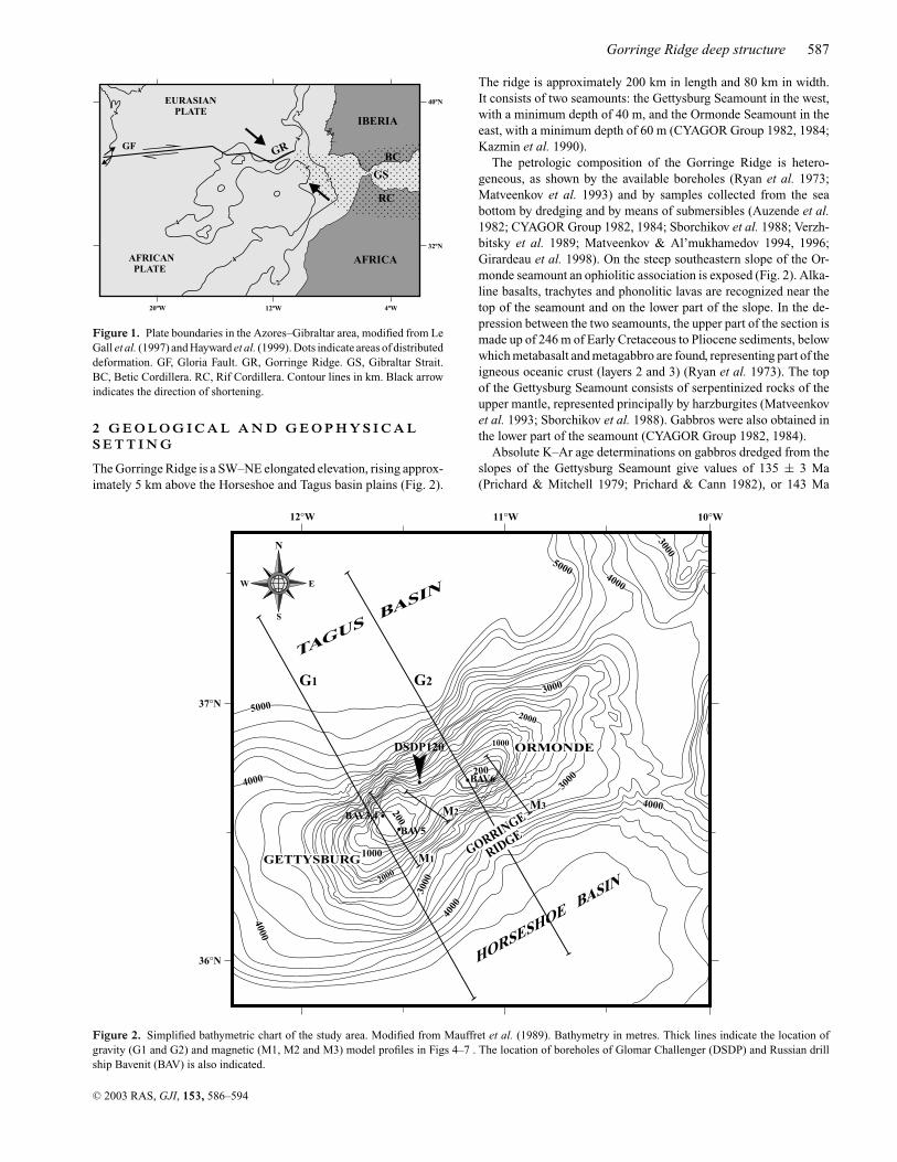
The Eurasian–African plate boundary, between the Azores triplejunction and the Gibraltar Strait, shows a tectonic regime thatchanges from transtension in the west to transpression in the east,with strike-slip motion in its central segment at the Gloria Fault(Fig. 1). Seismology reveals that while westwards of Gorringe Ridgethe plate boundary is located in a narrow zone, eastwards from thisarea, the plate boundary deformation spreads over a much broaderregion, more than 300 km wide (Fig. 1) (Griminson & Chen 1986;Jimenez-Munt et al. 2001). Plate motion calculations (Argus et al.1989; Kazmin et al. 1990; DeMets et al. 1994) indicate, moreover,that in the Gorringe Ridge area, the African and European plates areconverging at a relative rate of 0.25–0.42 cm yr−1 along a N145◦Evector.
The Gorringe Ridge drill site 120 (Ryan et al. 1973), the fourholes of Bavenit (Matveenkov et al. 1993) and the bottom sam-pling and submersible observations (CYAGOR Group 1982, 1984;Sborchikov et al. 1988; Verzhbitsky et al. 1989; Matveenkov &Al’mukhamedov 1994, 1996; Girardeau et al. 1998) (Fig. 2) clearlyshow the basic and ultrabasic composition and the oceanic natureof the rocks in this area. Most authors also agree that the GorringeRidge oceanic crust was formed in an extensional setting duringthe Early Cretaceous. Girardeau et al. (1998) point out that high-temperature and low-temperature shear zones deformed the peri-dotites and gabbros, producing interlayering of these rocks beforethe deposition of Cretaceous sediments. Le Gall et al. (1997) pro-
pose that a former Gorringe Ridge was formed at this time by upwardarching of the crust. Sartori et al. (1994) and Le Gall et al. (1997)relate the present-day location of the Gorringe Ridge to a formertransform discontinuity. Most of these authors (e.g. Sartori et al.1994; Le Gall et al. 1997; Girardeau et al. 1998) agree that the Gor-ringe Ridge was deformed and amplified since Miocene times andsuggest mechanisms that produce upward arching of the crust, suchas folding of lithospherical size (Verzhbitsky et al. 1989; Bergeron& Bonnin 1991; Sartori et al. 1994; Le Gall et al. 1997; Girardeauet al. 1998; Hayward et al. 1999) or isostatic upward movement byserpentinization of peridotites (Girardeau et al. 1998).
Some authors have proposed, in addition, that the present-dayactivity in the ridge results from a single reverse fault in the north-western side (Srivastava et al. 1990; Hayward et al. 1999) or inthe southeastern side (Morel & Meghraoui 1996). Other authors,in contrast, indicate the existence of two conjugated reverse faults(Kazmin et al. 1990; Tortella et al. 1997) or a fault zone with apredominantly northward deformation front (Le Gall et al. 1997).
The main objective of this study is to determine the deep structureof the ridge on the basis of the geophysical and geological data avail-able for the area: gravity and magnetic fields, bottom topography,seismicity, seismic data, drilling and dredging data. The analysisof all of these data allows us to propose a new model for the re-cent development of the Gorringe Ridge. We also improve upon theknowledge of the present-day structure of this transitional regionof the Eurasian and African plate boundary in the eastern centralAtlantic, from a narrow to a widespread zone of deformation.
586 C© 2003 RAS
Gorringe Ridge deep structure 587
IBERIA
AFRICA
GS
BC
RC
AFRICANPLATE
EURASIANPLATE
GFGR
4
4
4
2
2
2
4
4
4
20ºW 12ºW 4ºW
32ºN
40ºN
Figure 1. Plate boundaries in the Azores–Gibraltar area, modified from LeGall et al. (1997) and Hayward et al. (1999). Dots indicate areas of distributeddeformation. GF, Gloria Fault. GR, Gorringe Ridge. GS, Gibraltar Strait.BC, Betic Cordillera. RC, Rif Cordillera. Contour lines in km. Black arrowindicates the direction of shortening.
2 G E O L O G I C A L A N D G E O P H Y S I C A LS E T T I N G
The Gorringe Ridge is a SW–NE elongated elevation, rising approx-imately 5 km above the Horseshoe and Tagus basin plains (Fig. 2).
G1 G2
M1
M2M3
N
E
S
W
TAGUS BASIN
HORSESHOE BASIN
GETTYSBURG
ORMONDE
GORRINGE
RIDGE
DSDP120
.
4000
4000
4000
4000
4000
5000
5000
3000
1000
1000
2000
2000
3000
3000
3000
200
200
12°W 11°W 10°W
37°N
36°N
..
.BAV6
BAV5
BAV3,4
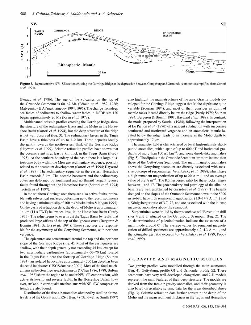
Figure 2. Simplified bathymetric chart of the study area. Modified from Mauffret et al. (1989). Bathymetry in metres. Thick lines indicate the location ofgravity (G1 and G2) and magnetic (M1, M2 and M3) model profiles in Figs 4–7 . The location of boreholes of Glomar Challenger (DSDP) and Russian drillship Bavenit (BAV) is also indicated.
The ridge is approximately 200 km in length and 80 km in width.It consists of two seamounts: the Gettysburg Seamount in the west,with a minimum depth of 40 m, and the Ormonde Seamount in theeast, with a minimum depth of 60 m (CYAGOR Group 1982, 1984;Kazmin et al. 1990).
The petrologic composition of the Gorringe Ridge is hetero-geneous, as shown by the available boreholes (Ryan et al. 1973;Matveenkov et al. 1993) and by samples collected from the seabottom by dredging and by means of submersibles (Auzende et al.1982; CYAGOR Group 1982, 1984; Sborchikov et al. 1988; Verzh-bitsky et al. 1989; Matveenkov & Al’mukhamedov 1994, 1996;Girardeau et al. 1998). On the steep southeastern slope of the Or-monde seamount an ophiolitic association is exposed (Fig. 2). Alka-line basalts, trachytes and phonolitic lavas are recognized near thetop of the seamount and on the lower part of the slope. In the de-pression between the two seamounts, the upper part of the section ismade up of 246 m of Early Cretaceous to Pliocene sediments, belowwhich metabasalt and metagabbro are found, representing part of theigneous oceanic crust (layers 2 and 3) (Ryan et al. 1973). The topof the Gettysburg Seamount consists of serpentinized rocks of theupper mantle, represented principally by harzburgites (Matveenkovet al. 1993; Sborchikov et al. 1988). Gabbros were also obtained inthe lower part of the seamount (CYAGOR Group 1982, 1984).
Absolute K–Ar age determinations on gabbros dredged from theslopes of the Gettysburg Seamount give values of 135 ± 3 Ma(Prichard & Mitchell 1979; Prichard & Cann 1982), or 143 Ma
C© 2003 RAS, GJI, 153, 586–594
588 J. Galindo-Zaldıvar, A. Maldonado and A. A. Schreider
0 30 km
Lithospheric Mantle
NW SET
WT
(s)
HORSESHOEBASIN
RIDGEGORRINGETAGUSBASIN
MOHO
MOHO
top of oceanic crust
Acoustic basement
??
?
0
2
4
6
8
10
12
Figure 3. Representative NW–SE section crossing the Gorringe Ridge at the depression between Gettysburg and Ormonde seamounts (simplified from Sartoriet al. 1994).
(Feraud et al. 1986). The age of the volcanics on the top ofthe Ormonde Seamount is 60–67 Ma (Feraud et al. 1982, 1986;Matveenkov & Al’mukhamedov 1994, 1996). The change from deepsea facies of sediments to shallow water facies in DSDP site 120began approximately 20 Ma (Ryan et al. 1973).
Multichannel seismic profiles crossing the Gorringe Ridge showthe structure of the sedimentary layers and the Moho in the Horse-shoe Basin (Sartori et al. 1994), but the deep structure of the ridgeis not well observed (Fig. 3). The sedimentary layers in the TagusBasin have a thickness of up to 1–2 km. These deposits locallydip gently towards the northwestern flank of the Gorringe Ridge(Hayward et al. 1999). Seismic refraction profiles have shown thatthe oceanic crust is at least 8 km thick in the Tagus Basin (Purdy1975). At the southern boundary of the basin there is a large olis-tostrome body within the Miocene sedimentary sequence, possiblyrelated to the seamount development (Sartori et al. 1994; Haywardet al. 1999). The sedimentary sequence in the eastern HorseshoeBasin exceeds 3 km. The oceanic basement and the sedimentarycover are deformed by southward and northward vergent reversefaults found throughout the Horseshoe Basin (Sartori et al. 1994;Tortella et al. 1997).
In the southern Gorringe area there are also active faults, proba-bly with subvertical surfaces, deforming up to the recent sedimentsand having a minimum slip of 100 m (Moskalenko & Kogan 1995).On the basis of refraction data, the depth of Moho is approximately14 km (11 s TWT) below sea level in the Horseshoe Basin (Purdy1975). The ridge seems to overthrust the Tagus Basin by faults thatproduced large offsets of the top of the igneous crust (Bergeron &Bonnin 1991; Sartori et al. 1994). These structures are responsi-ble for the asymmetry of the Gettysburg Seamount, with northernvergence.
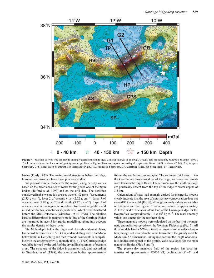
The epicentres are concentrated around the top and the northernslope of the Gorringe Ridge (Fig. 4). Most of the earthquakes areshallow, with their depth generally not exceeding 45 km, except fortwo intermediate earthquakes (approximately 60–70 km) locatedin the Tagus Basin near the footstep of Gorringe Ridge (Souriau1984); an isolated hypocentre approximately 206 km deep has beendetected in this area (USGS database 2001). Most of the focal mech-anisms in the Gorringe area (Griminson & Chen 1986, 1988; Bufornet al. 1988) show the region to be under NW–SE compression, withactive strike-slip and reverse faults. In the Horseshoe Basin, how-ever, strike-slip earthquake mechanisms with NE–SW compressiontrends are also found.
Distribution of the free-air anomalies obtained by satellite altime-try data of the Geosat and ERS-1 (Fig. 4) (Sandwell & Smith 1997)
also highlight the main structures of the area. Gravity models de-veloped for the Gorringe Ridge suggest that Moho depths are quitevariable (Souriau 1984), and most of them consider an uplift ofmantle rocks located directly below the ridge (Purdy 1975; Souriau1984; Bergeron & Bonnin 1991; Hayward et al. 1999). In contrast,the model proposed by Souriau (1984), following the interpretationof Le Pichon et al. (1970) of a nascent subduction with successivesouthward and northward vergence and an anomalous mantle lo-cated below the ridge, leads to an increase in the Moho depth toapproximately 17 km.
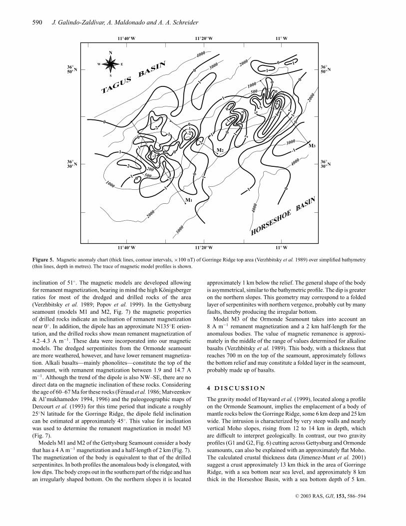
The magnetic field is characterized by local high-intensity short-period anomalies, with a span of up to 600 nT and horizontal gra-dients of more than 100 nT km−1, and some dipole-like anomalies(Fig. 5). The dipoles in the Ormonde Seamount are more intense thanthose of the Gettysburg Seamount. The main magnetic anomaliesabove the Gettysburg seamount are directly associated with mas-sive outcrops of serpentinites (Verzhbitsky et al. 1989), which havea high remanent magnetization of up to 20 A m−1 and an averagevalue of 3.2 A m−1. The Konigsberger ratio for these rocks rangesbetween 1 and 17. The geochemistry and petrology of the alkalinebasalts are well established by Girardeau et al. (1998). The basaltsdredged on the slopes of the Ormonde Seamount down to the 5000m isobath have high remanent magnetization (1.9–14.7 A m−1) anda Konigsberger ratio of 3.7–72, and are associated with the intensemagnetic anomalies above the seamount.
Serpentinites were drilled by the research vessel ‘Bavenit’ in drillsites 4 and 5, situated on the Gettysburg Seamount (Fig. 2). The34 determinations of paleoinclination indicate the existence of amain mode around 0◦. The average values for remanent magneti-zation of drilled specimens are approximately 4.2–4.3 A m−1, andthe Konigsberger ratio exceeds 40 (Verzhbitsky et al. 1989; Popovet al. 1999).
3 G R AV I T Y A N D M A G N E T I C M O D E L S
Two gravity profiles were modelled through the main seamounts(Fig. 4): Gettysburg, profile G1 and Ormonde, profile G2. Theseseamounts have very well-developed elongations, and 2-D modelsrepresent the main features of their deep structure. The models arederived from the free-air gravity anomalies, and their geometry isalso based on available seismic data for the areas described above(Fig. 3). Seismic refraction data further constrain the depth of theMoho and the mean sediment thickness in the Tagus and Horseshoe
C© 2003 RAS, GJI, 153, 586–594
Gorringe Ridge deep structure 589
G2G1
mGal
0 - 40 km 40 - 150 km > 150 km Depth
GR
HP
TP
SP
HS
CPSAS
Figure 4. Satellite-derived free-air gravity anomaly chart of the study area. Contour interval of 10 mGal. Gravity data processed by Sandwell & Smith (1997).Thick lines indicate the location of gravity model profiles in Fig. 6. Stars correspond to earthquake epicentre from USGS database (2001). AS, AmpereSeamount. CPS, Coral Patch Seamount. HP, Horseshoe Plain. HS, Hirondella Seamount. GR, Gorringe Ridge. SP, Seine Plain. TP, Tagus Plain.
basins (Purdy 1975). The main crustal structures below the ridge,however, are unknown from these previous studies.
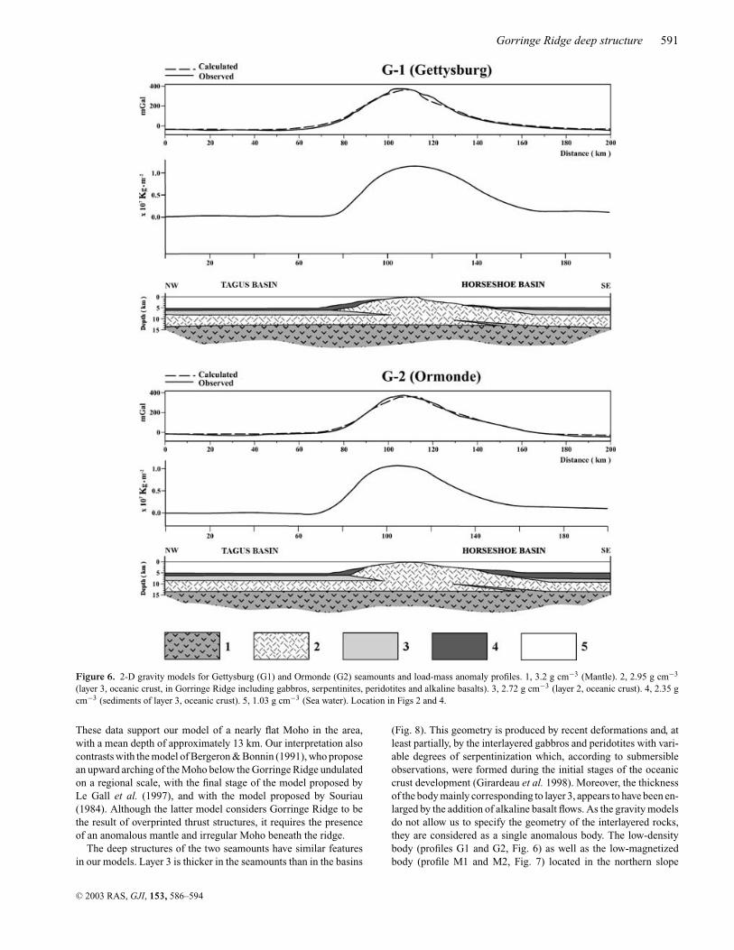
We propose simple models for the region, using density valuesbased on the mean densities of rocks forming each one of the mainbodies (Telford et al. 1990) and on the drill data. The densitiesconsidered in the two models are: sea water (1.03 g cm−3), sediments(2.35 g cm−3), layer 2 of oceanic crust (2.72 g cm−3), layer 3 ofoceanic crust (2.95 g cm−3) and mantle (3.32 g cm−3). Layer 3 ofoceanic crust in this region is considered to consist of gabbros andmixed peridotites, sometimes serpentinized, which were structuredbefore the Mid-Cretaceous (Girardeau et al. 1998). The alkalinebasalts differentiated in magnetic modelling of the Gorringe Ridgeare integrated in layer 3 for gravity modelling, taking into accountthe similar density of these rocks.
The Moho depth below the Tagus and Horseshoe abyssal plains,has been determined as 13.5–14 km, and modelling with a flat Mohobelow both the Gettysburg and the Ormonde seamounts is compati-ble with the observed gravity anomaly (Fig. 6). The Gorringe Ridgewould be formed by the uplift of the crystalline basement of oceaniccrust. The structure of the ridge is asymmetrical, and, accordingto Girardeau et al. (1998), the anomalous bodies approximately
follow the sea bottom topography. The sediment thickness, 1 kmthick on the northwestern slope of the ridge, increases northwest-ward towards the Tagus Basin. The sediments on the southern slopeare practically absent from the top of the ridge to water depths of3.5 km.
Calculations of mass load anomaly derived for the gravity modelsclearly indicate that the area of non-isostasy compensation does notexceed 80 km in width (Fig. 6), although anomaly values are variablein this area and the region of maximum values is approximately20 km in width. The anomalous load of the Gorringe Ridge for thetwo profiles is approximately 1.1 × 10⁷ kg m−2. The mass anomalyvalues are steeper for the northern slope.
Three magnetic models were calculated on the basis of the mag-netic anomalies observed over the Gorringe Ridge area (Fig. 7). Allthree models have a NW–SE trend, orthogonal to the ridge elonga-tion, though not located in the same transects of the gravity models.Models in 2.5 dimensions, taking into account the length of anoma-lous bodies orthogonal to the profile, were developed for the mainmagnetic dipoles (Figs 5 and 7).
The present-day magnetic field of the region has total in-tensities of approximately 42 000 nT, declination of –7◦ and
C© 2003 RAS, GJI, 153, 586–594
590 J. Galindo-Zaldıvar, A. Maldonado and A. A. Schreider
M1
M2M3
N
S
W E
0
0
0
0
0
0
0
45
00
0
0
0
0
0
0
1
1
1
1
1
1
1
1
1
3 33
1 1 2
2
22
2
-2
22
1
1
1
-1
-1
-1
-1
500
500
200
2000
1000
1000
2000
2000
3000
3000
3000
4000
4000
4000
11°40’ W 11°20’ W 11° W
11°40’ W 11°20’ W 11° W
36°50’N
36°30’N
36°50’N
36°30’N
HORSESHOE BASIN
TAGUS BASIN
Figure 5. Magnetic anomaly chart (thick lines, contour intervals, ×100 nT) of Gorringe Ridge top area (Verzhbitsky et al. 1989) over simplified bathymetry(thin lines, depth in metres). The trace of magnetic model profiles is shown.
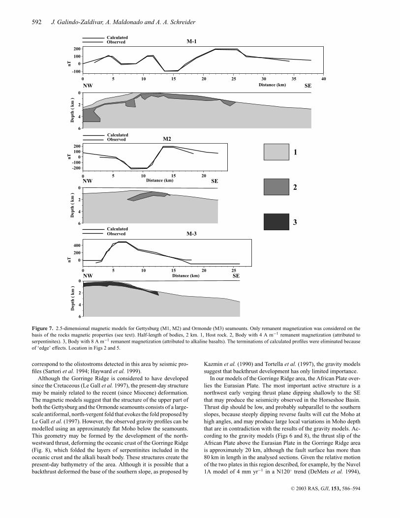
inclination of 51◦. The magnetic models are developed allowingfor remanent magnetization, bearing in mind the high Konigsbergerratios for most of the dredged and drilled rocks of the area(Verzhbitsky et al. 1989; Popov et al. 1999). In the Gettysburgseamount (models M1 and M2, Fig. 7) the magnetic propertiesof drilled rocks indicate an inclination of remanent magnetizationnear 0◦. In addition, the dipole has an approximate N135◦E orien-tation, and the drilled rocks show mean remanent magnetization of4.2–4.3 A m−1. These data were incorporated into our magneticmodels. The dredged serpentinites from the Ormonde seamountare more weathered, however, and have lower remanent magnetiza-tion. Alkali basalts—mainly phonolites—constitute the top of theseamount, with remanent magnetization between 1.9 and 14.7 Am−1. Although the trend of the dipole is also NW–SE, there are nodirect data on the magnetic inclination of these rocks. Consideringthe age of 60–67 Ma for these rocks (Feraud et al. 1986; Matveenkov& Al’mukhamedov 1994, 1996) and the paleogeographic maps ofDercourt et al. (1993) for this time period that indicate a roughly25◦N latitude for the Gorringe Ridge, the dipole field inclinationcan be estimated at approximately 45◦. This value for inclinationwas used to determine the remanent magnetization in model M3(Fig. 7).
Models M1 and M2 of the Gettysburg Seamount consider a bodythat has a 4 A m−1 magnetization and a half-length of 2 km (Fig. 7).The magnetization of the body is equivalent to that of the drilledserpentinites. In both profiles the anomalous body is elongated, withlow dips. The body crops out in the southern part of the ridge and hasan irregularly shaped bottom. On the northern slopes it is located
approximately 1 km below the relief. The general shape of the bodyis asymmetrical, similar to the bathymetric profile. The dip is greateron the northern slopes. This geometry may correspond to a foldedlayer of serpentinites with northern vergence, probably cut by manyfaults, thereby producing the irregular bottom.
Model M3 of the Ormonde Seamount takes into account an8 A m−1 remanent magnetization and a 2 km half-length for theanomalous bodies. The value of magnetic remanence is approxi-mately in the middle of the range of values determined for alkalinebasalts (Verzhbitsky et al. 1989). This body, with a thickness thatreaches 700 m on the top of the seamount, approximately followsthe bottom relief and may constitute a folded layer in the seamount,probably made up of basalts.
4 D I S C U S S I O N
The gravity model of Hayward et al. (1999), located along a profileon the Ormonde Seamount, implies the emplacement of a body ofmantle rocks below the Gorringe Ridge, some 6 km deep and 25 kmwide. The intrusion is characterized by very steep walls and nearlyvertical Moho slopes, rising from 12 to 14 km in depth, whichare difficult to interpret geologically. In contrast, our two gravityprofiles (G1 and G2, Fig. 6) cutting across Gettysburg and Ormondeseamounts, can also be explained with an approximately flat Moho.The calculated crustal thickness data (Jimenez-Munt et al. 2001)suggest a crust approximately 13 km thick in the area of GorringeRidge, with a sea bottom near sea level, and approximately 8 kmthick in the Horseshoe Basin, with a sea bottom depth of 5 km.
C© 2003 RAS, GJI, 153, 586–594
Gorringe Ridge deep structure 591
Figure 6. 2-D gravity models for Gettysburg (G1) and Ormonde (G2) seamounts and load-mass anomaly profiles. 1, 3.2 g cm−3 (Mantle). 2, 2.95 g cm−3
(layer 3, oceanic crust, in Gorringe Ridge including gabbros, serpentinites, peridotites and alkaline basalts). 3, 2.72 g cm−3 (layer 2, oceanic crust). 4, 2.35 gcm−3 (sediments of layer 3, oceanic crust). 5, 1.03 g cm−3 (Sea water). Location in Figs 2 and 4.
These data support our model of a nearly flat Moho in the area,with a mean depth of approximately 13 km. Our interpretation alsocontrasts with the model of Bergeron & Bonnin (1991), who proposean upward arching of the Moho below the Gorringe Ridge undulatedon a regional scale, with the final stage of the model proposed byLe Gall et al. (1997), and with the model proposed by Souriau(1984). Although the latter model considers Gorringe Ridge to bethe result of overprinted thrust structures, it requires the presenceof an anomalous mantle and irregular Moho beneath the ridge.
The deep structures of the two seamounts have similar featuresin our models. Layer 3 is thicker in the seamounts than in the basins
(Fig. 8). This geometry is produced by recent deformations and, atleast partially, by the interlayered gabbros and peridotites with vari-able degrees of serpentinization which, according to submersibleobservations, were formed during the initial stages of the oceaniccrust development (Girardeau et al. 1998). Moreover, the thicknessof the body mainly corresponding to layer 3, appears to have been en-larged by the addition of alkaline basalt flows. As the gravity modelsdo not allow us to specify the geometry of the interlayered rocks,they are considered as a single anomalous body. The low-densitybody (profiles G1 and G2, Fig. 6) as well as the low-magnetizedbody (profile M1 and M2, Fig. 7) located in the northern slope
C© 2003 RAS, GJI, 153, 586–594
592 J. Galindo-Zaldıvar, A. Maldonado and A. A. Schreider
NW SE0
2
4
6
Dep
th (
km
)
200
100
0
-100
nT
CalculatedObserved M-1
Distance (km)100 5 15 20 25 30 35 40
200100
0-100-200
n
T
0Distance (km)
5 10 15 20
CalculatedObserved M2
NW SE0
2
4
6
Dep
th (
km
)nT
Distance (km)10
CalculatedObserved
0 5 15 20 25
400
200
0
M-3
NW SE0
2
4
6
Dep
th (
km
)
1
2
3
Figure 7. 2.5-dimensional magnetic models for Gettysburg (M1, M2) and Ormonde (M3) seamounts. Only remanent magnetization was considered on thebasis of the rocks magnetic properties (see text). Half-length of bodies, 2 km. 1, Host rock. 2, Body with 4 A m−1 remanent magnetization (attributed toserpentinites). 3, Body with 8 A m−1 remanent magnetization (attributed to alkaline basalts). The terminations of calculated profiles were eliminated becauseof ‘edge’ effects. Location in Figs 2 and 5.
correspond to the olistostroms detected in this area by seismic pro-files (Sartori et al. 1994; Hayward et al. 1999).
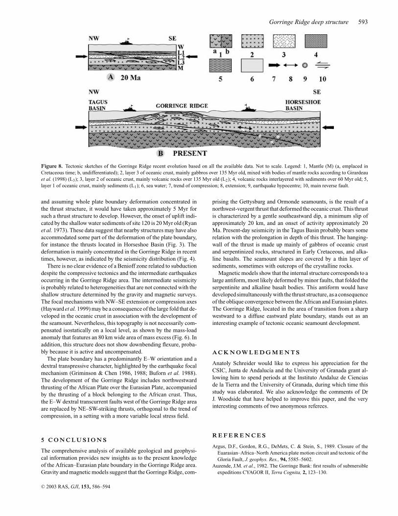
Although the Gorringe Ridge is considered to have developedsince the Cretaceous (Le Gall et al. 1997), the present-day structuremay be mainly related to the recent (since Miocene) deformation.The magnetic models suggest that the structure of the upper part ofboth the Gettysburg and the Ormonde seamounts consists of a large-scale antiformal, north-vergent fold that evokes the fold proposed byLe Gall et al. (1997). However, the observed gravity profiles can bemodelled using an approximately flat Moho below the seamounts.This geometry may be formed by the development of the north-westward thrust, deforming the oceanic crust of the Gorringe Ridge(Fig. 8), which folded the layers of serpentinites included in theoceanic crust and the alkali basalt body. These structures create thepresent-day bathymetry of the area. Although it is possible that abackthrust deformed the base of the southern slope, as proposed by
Kazmin et al. (1990) and Tortella et al. (1997), the gravity modelssuggest that backthrust development has only limited importance.
In our models of the Gorringe Ridge area, the African Plate over-lies the Eurasian Plate. The most important active structure is anorthwest early verging thrust plane dipping shallowly to the SEthat may produce the seismicity observed in the Horseshoe Basin.Thrust dip should be low, and probably subparallel to the southernslopes, because steeply dipping reverse faults will cut the Moho athigh angles, and may produce large local variations in Moho depththat are in contradiction with the results of the gravity models. Ac-cording to the gravity models (Figs 6 and 8), the thrust slip of theAfrican Plate above the Eurasian Plate in the Gorringe Ridge areais approximately 20 km, although the fault surface has more than80 km in length in the analysed sections. Given the relative motionof the two plates in this region described, for example, by the Nuvel1A model of 4 mm yr−1 in a N120◦ trend (DeMets et al. 1994),
C© 2003 RAS, GJI, 153, 586–594
Gorringe Ridge deep structure 593
Figure 8. Tectonic sketches of the Gorringe Ridge recent evolution based on all the available data. Not to scale. Legend: 1, Mantle (M) (a, emplaced inCretaceous time; b, undifferentiated); 2, layer 3 of oceanic crust, mainly gabbros over 135 Myr old, mixed with bodies of mantle rocks according to Girardeauet al. (1998) (L3); 3, layer 2 of oceanic crust, mainly volcanic rocks over 135 Myr old (L2); 4, volcanic rocks interlayered with sediments over 60 Myr old; 5,layer 1 of oceanic crust, mainly sediments (L1); 6, sea water; 7, trend of compression; 8, extension; 9, earthquake hypocentre; 10, main reverse fault.
and assuming whole plate boundary deformation concentrated inthe thrust structure, it would have taken approximately 5 Myr forsuch a thrust structure to develop. However, the onset of uplift indi-cated by the shallow water sediments of site 120 is 20 Myr old (Ryanet al. 1973). These data suggest that nearby structures may have alsoaccommodated some part of the deformation of the plate boundary,for instance the thrusts located in Horseshoe Basin (Fig. 3). Thedeformation is mainly concentrated in the Gorringe Ridge in recenttimes, however, as indicated by the seismicity distribution (Fig. 4).
There is no clear evidence of a Benioff zone related to subductiondespite the compressive tectonics and the intermediate earthquakesoccurring in the Gorringe Ridge area. The intermediate seismicityis probably related to heterogeneities that are not connected with theshallow structure determined by the gravity and magnetic surveys.The focal mechanisms with NW–SE extension or compression axes(Hayward et al. 1999) may be a consequence of the large fold that de-veloped in the oceanic crust in association with the development ofthe seamount. Nevertheless, this topography is not necessarily com-pensated isostatically on a local level, as shown by the mass-loadanomaly that features an 80 km wide area of mass excess (Fig. 6). Inaddition, this structure does not show downbending flexure, proba-bly because it is active and uncompensated.
The plate boundary has a predominantly E–W orientation and adextral transpressive character, highlighted by the earthquake focalmechanism (Griminson & Chen 1986, 1988; Buforn et al. 1988).The development of the Gorringe Ridge includes northwestwardthrusting of the African Plate over the Eurasian Plate, accompaniedby the thrusting of a block belonging to the African crust. Thus,the E–W dextral transcurrent faults west of the Gorringe Ridge areaare replaced by NE–SW-striking thrusts, orthogonal to the trend ofcompression, in a setting with a more variable local stress field.
5 C O N C L U S I O N S
The comprehensive analysis of available geological and geophysi-cal information provides new insights as to the present knowledgeof the African–Eurasian plate boundary in the Gorringe Ridge area.Gravity and magnetic models suggest that the Gorringe Ridge, com-
prising the Gettysburg and Ormonde seamounts, is the result of anorthwest-vergent thrust that deformed the oceanic crust. This thrustis characterized by a gentle southeastward dip, a minimum slip ofapproximately 20 km, and an onset of activity approximately 20Ma. Present-day seismicity in the Tagus Basin probably bears somerelation with the prolongation in depth of this thrust. The hanging-wall of the thrust is made up mainly of gabbros of oceanic crustand serpentinized rocks, structured in Early Cretaceous, and alka-line basalts. The seamount slopes are covered by a thin layer ofsediments, sometimes with outcrops of the crystalline rocks.
Magnetic models show that the internal structure corresponds to alarge antiform, most likely deformed by minor faults, that folded theserpentinite and alkaline basalt bodies. This antiform would havedeveloped simultaneously with the thrust structure, as a consequenceof the oblique convergence between the African and Eurasian plates.The Gorringe Ridge, located in the area of transition from a sharpwestward to a diffuse eastward plate boundary, stands out as aninteresting example of tectonic oceanic seamount development.
A C K N O W L E D G M E N T S
Anatoly Schreider would like to express his appreciation for theCSIC, Junta de Andalucıa and the University of Granada grant al-lowing him to spend periods at the Instituto Andaluz de Cienciasde la Tierra and the University of Granada, during which time thisstudy was elaborated. We also acknowledge the comments of DrJ. Woodside that have helped to improve this paper, and the veryinteresting comments of two anonymous referees.
R E F E R E N C E S
Argus, D.F., Gordon, R.G., DeMets, C. & Stein, S., 1989. Closure of theEuarasian–Africa–North America plate motion circuit and tectonic of theGloria Fault, J. geophys. Res., 94, 5585–5602.
Auzende, J.M. et al., 1982. The Gorringe Bank: first results of submersibleexpeditions CYAGOR II, Terra Cognita, 2, 123–130.
C© 2003 RAS, GJI, 153, 586–594
594 J. Galindo-Zaldıvar, A. Maldonado and A. A. Schreider
Bergeron, A. & Bonnin, J., 1991. The deep structure of Gorringe Bank (NEAtlantic) and its surrounding area, Geophys. J. Int., 105, 491–502.
Buforn, E., Udıas, A. & Colombas, M.A., 1988. Seismicity, source mech-anisms and tectonics of the Azores–Gibraltar plate boundary, Tectono-physics, 152, 89–118.
CYAGOR Group, 1982. The Gorringe Bank: first results of submersibleexpedition CYAGOR II, Terra Cognita, 2, 123–130.
CYAGOR Group, 1984. Intraoceanic tectonism on the Gorringe Bank: ob-servations by submersibile, in Ophiolites and Oceanic Lithosphere, pp.113–120, eds Gass, E.I.C., Lippard, S.J. & Shelton A.W., Spec. Publ. Geol.Soc., Oxford.
DeMets, C., Gordon, R.G., Argus, D.F. & Stein, S., 1994. Effect of recentrevisions to the geomagnetic reversal time scale on estimate of currentplate motions, Geophys. Res. Lett., 21, 2191–2194.
Dercourt, J., Ricou, L.E. & Verielynck, B., 1993. Atlas Tethys paleoenviron-mental maps. Gauthier-Villars, Paris, 14 sheets.
Feraud, G., Gastaud, J., Auzende, J.M., Olivet, J.L. & Cornen, G., , 1982.40Ar/39Ar for the alkaline volcanism and the basement of Gorringe Bank,North Atlantic Ocean, Earth. planet. Sci. Lett., 57, 211–226.
Feraud, G., York, D., Mevel, C., Cornen, G., Hall C. & Auzende, J., 1986.Additional Ar40–Ar39 dating of the basement and alkaline volcanism ofGorringe Bank (Atlantic ocean), Earth planet. Sci. Lett., 79, 255–269.
Girardeau, J. et al., 1998. Extensional tectonics in the Gorringe Bank rocks,Eastern Atlantic ocean: evidence of an oceanic ultra slow mantellic ac-creting centre, Terra Nova, 10, 330–336.
Griminson, N.L. & Chen, W.P., 1986. The Azores–Gibraltar plate boundary:focal mechanisms, depth of earthquakes and their tectonic implications,J. geophys. Res., 91, 2029–2047.
Griminson, N.L. & Chen, W.P., 1988. Source mechanisms of four recentearthquakes along Azores Gibraltar plate boundary, Geophys. J. Int., 92,391–401.
Hayward, N., Watts, A., Westbrook, G. & Collier, J., 1999. A seismic reflec-tion and GLORIA study of compressional deformation in the GorringeBank region, eastern North Atlantic, Geophys. J. Int., 138, 831–850.
Jimenez-Munt, I., Fernandez, M., Torne, M. & Bird, P., 2001. The tran-sition from linear to diffuse plate boundary in the Azores–Gibraltar re-gion: results from a thin-sheet model, Earth planet. Sci. Lett., 192, 175–189.
Kazmin, V.G., Marova, N.A., Alekhina, G.N. & Tichonova, N.F., 1990.Neogene–Quaternary deformation of the oceanic lithosphere in the vicin-ity of Gorringe bank, Atlantic, Izvestiya AN SSSR, seriya geologicheskaya,12, 48–56.
Le Gall, B., Pique, A., Rehault, J.P., Specht, M. & Malod J., 1997. Structure etmise en place d’ une ride oceanique dans un contexte de limite de plaquesconvergentes: le Banc de Gorringe (SW Iberie), C.R. Acad. Sci. Paris.,325, 853–860.
Le Pichon, X., Bonnin, J. & Pautot, G., 1970. The Gibraltar end of theAzores–Gibraltar plate boundary, an example of compressive tectonics.Upper Mantle Committee Symposium, Flagstaff, A.2.
Matveenkov, V.V. & Al’mukhamedov, A.I., 1994. Consistence of the Gor-ringe Bank ultrabasites (Atlantic ocean), Geochimia, 4, 616–622.
Matveenkov, V.V. & Al’mukhamedov, A.I., 1996. Alkalic volcanism of theGorringe bank, Atlantic ocean, Petrologia, 4, 46–56.
Matveenkov, V.V., Poyarkov, S.G., Dmitrenko, O.V., Al’mukhamedov, A.I.,Gamsakhurdia, G.R. & Kuznetsov, O.L., 1993. Geological particularitiesof the seamounts structure in Azoro-Gibraltar zone (based on results ofDeep Sea Drilling), Oceanologia, 33, 752–762.
Mauffret, A., Mougenot D., Miles P. & Malod J., 1989. Results from Mul-tichannel reflection profiling of the Tagus Abyssal Plain (Portugal)—comparision with the Canadian Margin, AAPG Memoir, 46, 379–393.
Morel, J.L. & Meghraoui, M., 1996. Gorringe–Alboran–Tell TectonicZone—a transpression system along the Africa–Eurasia plate boundary,Geology, 24, 755–758.
Moskalenko, V.N. & Kogan, L.I., 1995. Sedimentary cover structure in theeastern Azores–Gibraltar zone (the Horseshoe basin), Geotectonics, 28,334–343.
Prichard, H.M. & Cann, J.R., 1982. Petrology and mineralogy of dredgedgabbro from Gettysburg Bank, Eastern Atlantic, Contrib. Mineral. Petrol.,79, 46–55.
Prichard, H.M. & Mitchell, J.G., 1979. K–Ar data for the age and evolutionof the Gettysburg bank, North Atlantic ocean, Earth planet. Sci. Lett., 44,261–268.
Popov, K.V., Shcherbakov, B.P. & Tselmovich, V.A., 1999. The analysis ofmagnetic properties and results of Paleomagnetic investigation of serpen-tinites from Gorringe Ridge (Azoro-Gibraltar fracture zone), Oceanolo-gia, 39, 288–297.
Purdy, G.M., 1975. The Eastern End of the Azores–Gibraltar plate boundary,Geophys. J. R. astr. Soc., 43, 973–1000.
Ryan, W.B.F. et al., 1973. Init. Repts. DSDP, site 120, Washington DC, USGovernement Printing Office., 13, 19–39.
Sandwell, D.T. & Smith, W.H., 1997. Marine gravity anomaly from Geosatand ERS 1 satellite altimetry, J. geophys. Res., 102, 10 039–10 054.
Sartori, R., Torelli L., Zitellini N., Peis D. & Lodolo E., 1994. Eastern seg-ment of the Azores–Gibraltar line (central-eastern Atlantic): an oceanicplate boundary with diffuse compressional deformation, Geology, 22,555–558.
Sborchikov, I.M., Schreider, A.A., Rimsky-Korsakov, N.A. & Yastrebov,V.S., 1988. The Gorringe Ridge and Azoro-Gibraltar zone tectonics,Oceanologia, 28, 967–973.
Souriau, A., 1984. Geoid anomalies over Gorringe Ridge, North AtlanticOcean., Earth planet. Sci. Lett., 68, 101–114.
Srivastava, S., Roest, W., Kovacs, L., Oakey, G., Levesque S., Verhoef J.& Macnab R., 1990. Motion of Iberia since the late Jurassic: resultsfrom detailed aeromagnetic measurements in the Newfoundland Basin,Tectonophysics, 184, 229–260.
Telford, W.M., Geldart, L.P. & Sheriff, R.E., 1990. Applied Geophysics,p. 770. Cambridge University Press, Cambridge.
Tortella, D., Torne, M. & Perez-Estaun, A., 1997. Geodynamic evolution ofthe eastern segment of the Azoro-Gibraltar Zone of Cadiz region, Mar.Geophys. Res., 19, 211–230.
USGS database, 2001. National Earthquake Information Center,http://wwwneic.cr.usgs.gov/.
Verzhbitsky, Y., Gorodnitskiy, A., Yemelianov, M., Lobkovskiy, L., Marova,N., Sborschikov, I., Schreider, A.A. & Yastrebov V., 1989. New Data ongeologic structure and tectonic development of the underwater GorringeRidge (North Atlantic), Geotectonika, 1, 12–22.
C© 2003 RAS, GJI, 153, 586–594