Embed Size (px)
Citation preview

Gooseberry Point Ferry Dock Relocation Feasibility Study
Whatcom County Public Works Department
(In Cooperation With the Lummi Nation)
December 2009
PREPARED BY:
RH2 ENGINEERING, INC.

i 12/22/09 3:26 PM J:\Data\WCP\407-108\FINAL REPORT MATERIAL 12-2009\Final
feasibility report without appendices.doc
Whatcom County
Public Works Department
Gooseberry Point Ferry Dock Relocation Feasibility Study
December 2009
Prepared by RH2 Engineering, Inc. Prepared for Whatcom County Public Works Department Note: This Feasibility Study was completed under the direct supervision of the following
Licensed Professional Engineer, registered in the State of Washington.
Ken Thomas, P.E. Principle-In-Charge

ii 12/22/09 3:26 PM J:\Data\WCP\407-108\FINAL REPORT MATERIAL 12-
2009\Final feasibility report without appendices.doc
Forward Gooseberry Point Ferry Dock Relocation Feasibility Study
The task was to assess the feasibility of relocating the existing Gooseberry Point Ferry Dock to a new location and retain the existing level of service for ferry customers. In 2007, Whatcom County and the Lummi Nation (collectively “the Parties”) jointly approved the scope of work for the project and both governments have approved the study objectives and the work products throughout the project. The original project envisioned the following 6 phases:
Phase 1: Rating and Ranking of Alternatives Phase 2: Preliminary Design and Environmental Compliance Phase 3: Funding and Permitting Phase 4: Final Design Phase 5: Construction Phase 6: Start-up and Project Close-out
This report is the product of Phase 1. There are currently neither plans nor funding to proceed beyond Phase 1. In Phase 1, fourteen potential sites, including a Fairhaven site, were reduced to five sites by the Parties based on the criteria established by the Parties and the need to maintain the existing level of service. These remaining five sites were evaluated in much more detail. They are: West of the existing dock, Mt. Baker Plywood, Hilton Harbor, and Whatcom Waterway (two configurations). The sites were all compared to the existing site at Gooseberry Point because a decision had not been made to relocate the existing dock but, rather, to evaluate the feasibility of relocating it to a new location. The sites were evaluated for a number of factors, including environmental impacts, geotechnical issues, cultural and historic resource issues, the likelihood of obtaining permits, and estimated costs. A fatal flaw analysis was conducted. No fatal flaws were found and all sites appear feasible although the site west of the existing dock has a significant cultural resource site nearby which could be problematic. In every case, it appears that permits could be obtained and mitigation (either on-site or off-site) could be designed to address adverse impacts. The report finds that all of these locations appear to be feasible for a new dock although it may not be economically practicable to relocate the dock and maintain the existing level of service for ferry customers at all locations. All sites in Bellingham Bay have significantly higher costs due to the need to construct a new dock at those locations, the need for a larger ferry, and the need to modify the dock on Lummi Island to accommodate the larger ferry. Continued use of the Whatcom Chief to provide service to Bellingham would greatly reduce the level of service and would significantly increase the costs of operation, half of which is required to be borne by ferry passengers.

iii 12/22/09 3:26 PM J:\Data\WCP\407-108\FINAL REPORT MATERIAL 12-
2009\Final feasibility report without appendices.doc
Whatcom County Public Works Department Gooseberry Point Ferry Dock Relocation Feasibility Study
Table of Contents
EXECUTIVE SUMMARY............................................................................................ 1
CHAPTER 1: BACKGROUND ...................................................................................4
TASK 101 – DETERMINE PROJECT OBJECTIVES ..........................................................................5 TASK 102 – IDENTIFY POSSIBLE LOCATIONS...............................................................................5
CHAPTER 2: TASK 103 − ANALYSIS OF POTENTIAL FATAL FLAWS RELATED TO REGULATORY, NATURAL RESOURCE, AND TRIBAL USUAL AND ACCUSTOMED HARVESTS ....................9
GENERAL EXISTING CONDITIONS ................................................................................................9 NATURAL RESOURCES, TRIBAL USUAL AND ACCUSTOMED AREAS, AND MITIGATION
OPPORTUNITIES..............................................................................................................................10 TRIBAL USUAL AND ACCUSTOMED AREAS .................................................................................10 SPECIFIC SITE INFORMATION AND MITIGATION OPPORTUNITIES.........................................10 IMPACTS AND REGULATORY REQUIREMENTS............................................................................15 CONCLUSIONS .................................................................................................................................16
CHAPTER 3: TASK 103 − GEOTECHNICAL CONSIDERATIONS.................... 18
EXISTING DOCK .............................................................................................................................18 WEST OF EXISTING DOCK ............................................................................................................20 MT. BAKER PLYWOOD ...................................................................................................................21 HILTON HARBOR............................................................................................................................23 WHATCOM WATERWAY .................................................................................................................25 CONCLUSIONS .................................................................................................................................27
CHAPTER 4: TASK 103 − CULTURAL RESOURCE CONSIDERATIONS......... 30
REGULATORY CONTEXT ...............................................................................................................30 TRIBAL COORDINATION................................................................................................................30 PROJECT SETTING ..........................................................................................................................31 METHODS ........................................................................................................................................31 PREVIOUS RESEARCH.....................................................................................................................31 EXPECTATIONS ...............................................................................................................................32 RECOMMENDATIONS .....................................................................................................................33
CHAPTER 5: TASK 103 − ENGINEERING AND NAVIGATION ISSUES ......... 34
POTENTIAL ENGINEERING ISSUES ..............................................................................................34 EXISTING DOCK AND LOCATION WEST OF EXISTING DOCK ................................................35 DOWNTOWN BELLINGHAM SITES (HILTON HARBOR, WHATCOM WATERWAY, MT. BAKER PLYWOOD).......................................................................................................................................36 HILTON HARBOR............................................................................................................................36 WHATCOM WATERWAY .................................................................................................................37

iv 12/22/09 3:26 PM J:\Data\WCP\407-108\FINAL REPORT MATERIAL 12-
2009\Final feasibility report without appendices.doc
MT. BAKER PLYWOOD ...................................................................................................................37 POTENTIAL NAVIGATION ISSUES.................................................................................................37
CHAPTER 6: TASK 103 − ECONOMICS AND PLANNING LEVEL COST ESTIMATES.................................................................................... 38
CHAPTER 7: TASK 103 − IDENTIFICATION AND DISCUSSION OF FATAL FLAWS.............................................................................................. 46
CHAPTER 8: TASK 104 − ALTERNATIVE RATING AND RANKING............... 47
CHAPTER 9: TASK 105 − INTEGRATION WITH EXISTING PLANS............... 49
LUMMI NATION TRAFFIC SAFETY STUDY ...................................................................................49 LUMMI NATION TRANSPORTATION PLAN ..................................................................................50
REFERENCES .......................................................................................................... 52
APPENDICES .......................................................................................................... 53
APPENDIX A – TASK 102 SITE RANKING MATRIX
APPENDIX B – TASK 102 SITE RANKING SCORES AND COMMENTS
APPENDIX C – TRIBAL USUAL AND ACCUSTOMED AREAS, NATURAL RESOUCES AND PERMITABILITY SCREENING METHODOLOGY AND RESULTS
APPENDIX D – CULTURAL/HISTORICAL RESOURCE CONSIDERATIONS
APPENDIX E – CHAPTER 4 LUMMI INDIAN TRAFFIC SAFETY STUDY (AMENDED)

Whatcom County Public Works Department Executive Summary
Gooseberry Point Ferry Dock Relocation Feasibility Study
1 12/22/09 3:26 PM J:\Data\WCP\407-108\FINAL REPORT MATERIAL 12-2009\Final
feasibility report without appendices.doc
Executive Summary
The Gooseberry Point Ferry Dock Relocation Feasibility Study was conducted under the leadership of the Whatcom County Public Works Department (County) in conjunction with the Lummi Indian Nation. RH2 Engineering, Inc. (RH2) was the lead consultant and retained Anchor QE (Anchor) for environmental assessments and usual and accustomed areas analysis, and Aspect Consulting (Aspect) for geotechnical investigations. A fourth member of the consulting team, Northwest Archaeological Associates (NWAA), was mutually agreed upon by the County and the Lummi Nation to provide cultural resource planning services for the project.
The overall project consists of the following six phases.
Phase 1: Rating and Ranking of Alternatives
Phase 2: Preliminary Design and Environmental Compliance
Phase 3: Funding and Permitting
Phase 4: Final Design
Phase 5: Construction
Phase 6: Start-up and Project Close-out
This report is the result of Phase 1, which consisted of the following tasks.
Task 101: Determine Project Objectives
Task 102: Identify Possible Locations
Task 103: Fatal Flaw Analysis
Task 104: Alternative Rating and Ranking
Task 105: Integration with Existing Plans
Phase 1 was intended to achieve at least two objectives: 1) to result in a short list of alternatives for achieving the project’s objectives and; 2) to provide a solid foundation for the successful completion of the subsequent phases.
The Scope of Work for this project was approved March 2007. Whatcom County provided the notice to proceed in September 2007.
In May 2008, the following project objectives were approved by the Lummi Nation and the County.
• Establish a clear understanding and acceptance of the process that will be implemented to identify and analyze alternative ferry dock location scenarios and select a preferred alternative that will:
o Recognize and value the long-term vision of both the Lummi Nation and the County for the Lummi Reservation, including the Gooseberry Point area;
o Maintain safe and reliable ferry service between the mainland and Lummi Island;
o Foster the development of a multi-modal transportation center and ancillary development for pedestrians, bicycles, motorcycles, cars, trucks, busses, fishing vessels, canoes, the ferry and a marina;

Whatcom County Public Works Department Executive Summary
Gooseberry Point Ferry Dock Relocation Feasibility Study
2 12/22/09 3:26 PM J:\Data\WCP\407-108\FINAL REPORT MATERIAL 12-
2009\Final feasibility report without appendices.doc
o Avoid or mitigate traffic impacts from ferry-related traffic on the Lummi Reservation, including accidents, congestion, parking, and conflicts between motor vehicle, pedestrian and bicycle traffic;
o Avoid or mitigate significant environmental impacts;
o Avoid or mitigate impacts to treaty reserved usual and accustomed fishing, hunting and harvesting areas; and
o Avoid significant impacts on archaeological and historic resources in the project area.
In March 2009, the consultant team provided a report to the Lummi Nation and the County identifying 14 possible locations for an alternative to the existing Gooseberry Point Ferry Dock. It has not been decided if the existing dock will be eliminated; therefore, the existing dock was retained as one of the alternative locations throughout the project.
Based on the results of Task 102, the list of 14 sites was reduced to the following 5 sites.
1. West of the Existing Dock
2. Hilton Harbor
3. Whatcom Waterway
4. Mt. Baker Plywood
5. Existing Dock
Following the review period, work began on the remainder of Phase 1 (Tasks 103, 104 and 105). This report is the final report for Phase 1 of the project.
The five remaining potential locations were the focus of further analysis in Tasks 103 and 104, the fatal flaw analysis and alternative rating and ranking, respectively, which are discussed in detail in this report. In looking at the physical configuration of the Whatcom Waterway site, an additional site was considered at the Whatcom Waterway location.
Summary and Conclusions
• None of the alternatives were found to have a fatal flaw that precluded them from further consideration; however, the location west of the existing dock is known to have a significant cultural resource site in close proximity. This should be further evaluated if there is an interest in developing this site in the future.
• The relocation of the Gooseberry Point dock to any of the downtown Bellingham locations would necessitate a number of changes, in addition to the creation of a new terminal in Bellingham. The longer route across open water would require the design and construction of a significantly larger ferry boat. This larger boat would be necessary to ensure safety during adverse weather conditions. It would also be required to provide enhanced passenger and vehicle capacity to retain the existing level of service because of the longer crossing time and less frequent sailings associated with the longer route.
• Because of the larger boat size, the downtown Bellingham locations would also require the design and construction of a second new terminal facility at Lummi Island because the existing facility would likely not accommodate the larger boat.

Whatcom County Public Works Department Executive Summary
Gooseberry Point Ferry Dock Relocation Feasibility Study
3 12/22/09 3:26 PM J:\Data\WCP\407-108\FINAL REPORT MATERIAL 12-
2009\Final feasibility report without appendices.doc
• The environmental and geotechnical issues at each of the alternative sites appear to be issues that can be eliminated or lessened through the design process and/or mitigated through the permitting process. The exception may be the location west of the existing dock because of the presence of a significant cultural resource site.
• Design and construction of one or more ferry docks, along with a new boat designed to provide the appropriate levels of safety and service, is a significant expense.

Whatcom County Public Works Department Chapter 1
Gooseberry Point Ferry Dock Relocation Feasibility Study
4 12/22/09 3:26 PM J:\Data\WCP\407-108\FINAL REPORT MATERIAL 12-2009\Final
feasibility report without appendices.doc
Chapter 1: Background
The purpose of the Gooseberry Point Ferry Dock Relocation Feasibility Study (Study) is to evaluate the feasibility of relocating the existing ferry dock. The existing ferry terminal is located at Gooseberry Point on the Lummi Peninsula within the exterior boundaries of the Lummi Indian Reservation. It has been operated by Whatcom County at this location since the early 1960s. Over the years, growth in commercial, residential and ferry-related traffic has caused an increasing number of conflicts between motorists, adjacent land uses and pedestrians, raising concerns over capacity and safety.
This ferry boat serves Lummi Island residents, visitors and businesses, and transported over 216,838 passengers in 2008. There was a total of 117,254 vehicle or passenger car trips and, combined with other types of vehicles (e.g., commercial trucks, garbage trucks), a total of 123,285 vehicles transported. Ridership shows strong seasonal variations. July and August remain the busiest months with over 10 percent of all vehicle and pedestrian trips occurring in each of these months. The permanent resident population is over 900, and during the summer the island population swells to over 2,000 people as seasonal residents or vacationers stay on the island. (Whatcom County Public Works, http://www.co.whatcom.wa.us/publicworks/ferry/index.jsp)
Because the Gooseberry Point Ferry Dock is located on the Lummi Indian Reservation, a lease agreement between the Parties is necessary. For most of the last 25 years, both the Lummi Nation and the County have been operating under the understanding that a lease existed because an agreement was signed by both Parties. However, it recently came to the attention of both Parties that the lease agreement was never signed by the Secretary of the U.S. Department of the Interior which is a requirement for lease agreements on Indian Reservations. The Lummi Nation has stated their contention that there is currently not a valid lease agreement. The existing 25-year agreement between Whatcom County (County) and the Lummi Nation, which is necessary for operation of the present Gooseberry Point ferry terminal by the County, expires on February 14, 2010 and the Parties are currently involved in discussions regarding a 5-year extension of the existing agreement. The Lummi Nation has expressed an interest in relocating the existing Gooseberry Point ferry terminal with the potential of creating a multi-modal center that would combine vehicle, bus, ferry and bicycle transportation modes on the Lummi Reservation. While the focus on the multi-modal center has diminished due, in part, to the lack of available funding, the Lummi Nation’s interest in the potential relocation of the ferry dock remains high. This Study evaluates a number of potential sites to determine the feasibility of establishing a new location for the Gooseberry Point Ferry dock and its related facilities.
The overall project has the following six phases.
Phase 1 − Rating and Ranking of Alternatives
Phase 2 − Preliminary Design and Environmental Compliance
Phase 3 − Funding and Permitting
Phase 4 − Final Design
Phase 5 − Construction
Phase 6 – Start-up and Project Close-out
All work to date has been on Phase 1 tasks. Phase 2 tasks will be undertaken when and if the decision is made to pursue the construction of a new ferry dock in a new location.
Phase 1 tasks are the subject of this report and have included the following.
Whatcom County Public Works Department Chapter 1
Gooseberry Point Ferry Dock Relocation Feasibility Study
5 12/22/09 3:26 PM J:\Data\WCP\407-108\FINAL REPORT MATERIAL 12-
2009\Final feasibility report without appendices.doc
Task 101 – Determine Project Objectives
Task 102 – Identify Possible Locations
Task 103 – Fatal Flaw Analysis
Task 104 – Alternative Rating and Ranking
Task 105 – Integration with Existing Plans
Task 101 – Determine Project Objectives
The project objectives were developed by Whatcom County and the Lummi Nation and have been approved by the Lummi Indian Business Council and Whatcom County. The objectives are as follows.
• Establish a clear understanding and acceptance of the process that will be implemented to identify and analyze alternative ferry dock location scenarios and select a preferred alternative that will:
o Recognize and value the long-term vision of both the Lummi Nation and Whatcom County for the Lummi Reservation including the Gooseberry Point area;
o Maintain safe and reliable ferry service between the mainland and Lummi Island;
o Foster the development of a multi-modal transportation center and ancillary development for pedestrians, bicycles, motorcycles, cars, trucks, busses, fishing vessels, canoes, the ferry and a marina;
o Avoid or mitigate traffic impacts from ferry-related traffic on the Lummi Reservation, including accidents, congestion, parking, and conflicts between motor vehicle, pedestrian and bicycle traffic;
o Avoid or mitigate significant environmental impacts;
o Avoid or mitigate impacts to treaty reserved usual and accustomed fishing, hunting and harvesting areas; and
o Avoid significant impacts on archaeological and historic resources in the project area.
Task 102 – Identify Possible Locations
Once the study objectives were agreed upon in Task 101, work began on the identification of potential alternative ferry dock locations (Task 102). Because a decision has not been made to relocate the Gooseberry Point ferry dock, the existing dock location was retained and evaluated as one of the potential future sites.
Fourteen potential sites were identified, including the existing site, as shown in Figure 1. Two of these sites (Grace Ericson and Beach Way) were suggested by the Lummi Nation and were included in the study.
A Site Ranking Matrix (Appendix A) was prepared and each of the 14 sites was ranked according to the evaluation criteria. The criteria in the left column are the approved study objectives and include five additional items: 1) anticipated total costs; 2) anticipated operation and maintenance (O&M)

Whatcom County Public Works Department Chapter 1
Gooseberry Point Ferry Dock Relocation Feasibility Study
6 12/22/09 3:26 PM J:\Data\WCP\407-108\FINAL REPORT MATERIAL 12-
2009\Final feasibility report without appendices.doc
costs; 3) available land; 4) suitable land elevations; and 5) suitable water depth (bathymetry). These were included after being recommended by RH2 and approved by County staff.
This list also includes four criteria added by the Lummi Nation: 1) safety of alternative vessels (where a new ferry boat would be required); 2) fishing impacts; 3) local infrastructure; and 4) access to destinations. These were also subsequently approved by the County. Although one of the criteria is geotechnical considerations, it was decided not to evaluate each of the 14 sites on that basis and to evaluate geotechnical issues as part of the fatal flaw analysis under Task 103.
Figure 1: Potential Ferry Dock Sites
For the purposes of comparing the alternatives to the existing Gooseberry Point Ferry Dock, the existing dock was given a value of 0 for each of the objectives. Alternative sites that better satisfied any of the objectives received a score of plus 1 or 2. Those that posed greater impacts or were less compatible with the objectives received a negative score of 1 or 2. For example, a site that posed significant safety improvements received a +2, and a site that was significantly less safe received a -2.
The next step was to use the matrix rankings to narrow the list of potential sites to four or five. Task 103 was a more rigorous analysis of each of these remaining sites in what is being called the fatal flaw analysis. Task 104 resulted in a ranking of these sites on the basis of the more rigorous analysis. Both Tasks 103 and 104 are discussed in detail in this report.
The values in the matrix were assigned by the consultants and County staff assigned to this project. RH2 Engineering, Inc. (RH2) is the lead consultant and Anchor Environmental (now Anchor QEA,

Whatcom County Public Works Department Chapter 1
Gooseberry Point Ferry Dock Relocation Feasibility Study
7 12/22/09 3:26 PM J:\Data\WCP\407-108\FINAL REPORT MATERIAL 12-
2009\Final feasibility report without appendices.doc
LLC), Aspect Consulting and Northwest Archaeological Associates are sub-consultants to RH2. County Public Works staff providing evaluation numbers and other information included Mr. Ken Richardson, Special Projects Manager, Mr. Jim Perkins, Real Estate Manager, Ms. Chantelle Hilsinger, Ferry Coordinator, and Mr. Fred Nyland, Senior Master.
For this initial ranking, the values were established based on existing information. More detailed analysis was performed in Task 103 when the fatal flaw analysis was developed for the more limited number of alternatives.
Anchor QEA examined the expected impacts of alternative dock locations on natural resources and tribal usual and accustomed areas, and assessed the suitability of the sites in terms of bathymetry conditions and an overview of the ability to obtain the necessary permits for a new ferry dock at each location. Anchor QEA prepared a separate report addressing existing conditions at the existing ferry dock that served as the baseline for the comparison of the alternative sites. This report, which includes a separate matrix of environmental information, is included in Appendix C. The results of this matrix were compiled by Anchor QEA and a composite number was generated for each of the cells in the site ranking matrix.
Aspect Consulting examined and ranked the potential sites according to geotechnical considerations as part of Task 103, which is discussed in Chapter 3.
Northwest Archaeological Associates (NWAA) examined existing information at each site to evaluate potential impacts on known cultural and historic resources. In doing so, NWAA conducted record searches with the Washington State Department of Archaeology and Historic Preservation (DAHP). An attempt was made to involve the Lummi Nation Culture Department in assigning numbers to the matrix, but no response was received. RCW 42.56.300 states that records, maps, or other information identifying the location of archaeological sites are exempt from disclosure in order to avoid the looting or depredation of such sites.
A summary of NWAA’s report is included in Chapter 4 and includes all of the necessary information without violating RCW 42.56.300. A copy of the Cultural Resources Assessment is available at the Department of Archaeology and Historic Preservation in Olympia, Washington. Limited copies of this report (for Whatcom County and the Lummi Nation) include a copy of this Cultural Resources Assessment as Appendix 4.
Each person that ranked a site against a given rating criterion provided a brief (two- to three-sentence) explanation for the number assigned to that cell in the matrix. Those comments were compiled and are included in Appendix B.
Matrix Results
Once the values were assigned to each cell in the matrix, the columns were totaled. Total scores ranged from a low of -16 to a high of +3. These numbers are in reference to the existing dock location, which was assigned a value of 0 in all categories for comparison purposes. Based on these totals, the sites were ranked from high to low score.
The sites receiving the four highest rankings in Task 102 are shown in Table 1.

Whatcom County Public Works Department Chapter 1
Gooseberry Point Ferry Dock Relocation Feasibility Study
8 12/22/09 3:26 PM J:\Data\WCP\407-108\FINAL REPORT MATERIAL 12-
2009\Final feasibility report without appendices.doc
Table 1: Ranking of Potential Sites
Rank Site Name
1 West of Existing Dock
2 Hilton Harbor
3 Whatcom Waterway
4 (tie) Mt. Baker Plywood
4 (tie) Existing Location
Based on the site ranking described above, the sites identified for further study are those shown in Table 1.

Whatcom County Public Works Department Chapter 2
Gooseberry Point Ferry Dock Relocation Feasibility Study
9 12/22/09 3:26 PM J:\Data\WCP\407-108\FINAL REPORT MATERIAL 12-2009\Final
feasibility report without appendices.doc
Chapter 2: Task 103 − Analysis of Potential Fatal Flaws
Related to Regulatory, Natural Resource, and Tribal Usual and Accustomed Harvests
This chapter provides an analysis of the potential fatal flaws related to regulatory, natural resources, and tribal usual and accustomed harvests for each of the remaining alternative sites. This includes analysis of the regulatory considerations associated with redeveloping existing or developing new facilities to accommodate the Lummi Island Ferry Terminal. Five of the original 14 sites reviewed by the Study team are analyzed in this chapter, with specific emphasis on any regulatory issues that would inhibit the project from obtaining needed permits and approvals.
Following preliminary review and analysis of 14 initial sites, the Study team selected five potential sites that were best suited for the ferry terminal (see Figure 1): 1) the existing site; 2) an area west of the existing site; 3) Mt. Baker Plywood; 4) Hilton Harbor; and 5) Whatcom Waterway (note: two potential sites were identified at the Whatcom Waterway location).
For this analysis, a redeveloped existing ferry terminal scenario was used as the baseline condition from which to compare the conditions at the five sites that would influence the ability to obtain regulatory approvals for a ferry terminal at those locations. The five potential sites were assessed and assigned a score based on how they compare to the baseline condition. Tables showing the rankings of the five sites for these factors are in Appendix C. The methods used to determine the relative score for each of these categories are provided, along with the assumptions included in the ranking criteria. Additionally, each of the five sites was analyzed to determine whether constructing a ferry terminal at that site that would result in impacts that could not be avoided or mitigated and that would prohibit the project from obtaining necessary regulatory approvals.
General Existing Conditions
The Lummi Island ferry serves as a vehicle and passenger ferry to Lummi Island from Gooseberry Point for Lummi Island residents, visitors, and businesses. The ferry is the only transportation link from Lummi Island to the mainland for the majority of the island’s residents. The existing terminal includes a pier (with bulkhead and piling in place), holding lanes and a parking area. It is assumed for the purposes of this Study that any new or redeveloped facilities would serve the same purposes as, and contain similar infrastructure to, the existing terminal.
The existing ferry terminal site and the site west of the existing ferry terminal are both located on the west side of the Lummi Peninsula on the Lummi Indian Reservation. The three other potential sites (Mt. Baker Plywood, Hilton Harbor, and Whatcom Waterway) are located in Bellingham Bay within jurisdiction of the City of Bellingham, Washington. A site visit was conducted on July 7, 2009, to review conditions and potential locations for each site. Photographs were taken at each site from the closest possible location without trespassing onto private property. Preliminary bathymetric information was obtained from National Oceanic and Atmospheric Administration (NOAA) Raster Navigational Charts to determine whether adequate depths were present at each of the potential sites for sustained ferry operation (NOAA, 2009). These studies show that depths at the five potential sites are adequate for operation of the existing ferry and would require minimal to no dredging pending final dock lengths and boat draft studies. Further information on existing natural resources and tribal usual and accustomed harvest areas is included in the following sections.

Whatcom County Public Works Department Chapter 2
Gooseberry Point Ferry Dock Relocation Feasibility Study
10 12/22/09 3:26 PM J:\Data\WCP\407-108\FINAL REPORT MATERIAL 12-
2009\Final feasibility report without appendices.doc
Natural Resources, Tribal Usual and Accustomed Areas, and
Mitigation Opportunities
Natural resources are features that have ecological, economic, cultural, recreational, educational or aesthetic value and are known to occur naturally in the environment. They are primarily regulated by local governments and state, tribal, and federal agencies. Natural resources are addressed in this Study because of their value to the ecosystem or to human pursuits that support food, trade, or livelihood. Specific natural resources assessed for this project include forage fish, salmonids, fish and wildlife habitats, marine mammal haul-out sites, shellfish beds, eelgrass beds and critical areas (e.g., unstable slopes and wetlands) that exist within or in proximity to the five potential terminal sites.
The five potential sites are all located in developed and urbanized areas. However, regulated natural resources are known to exist at all five potential sites due to their proximity to Bellingham Bay. Natural resources that exist in proximity to all of the five potential sites include native oyster shellfish beds (Crassostrea gigas), juvenile and adult salmonid species (including federally listed species of Puget Sound Chinook salmon [Oncorhynchus tshawytscha], Puget Sound bull trout [Salvelinus confluentus], and Puget Sound steelhead [Oncorhynchus mykiss]), harbor porpoise (Phocoena phocoena), killer whale (Orcinus orca) and gray whale (Eschrichtius robustus). Specific information on the natural resources occurring at each site can be found in the Specific Site Information and Mitigation Opportunities section and Figures 2 through 5 in Appendix C. The general information in this paragraph regarding natural resource presence at each site is not repeated in the specific information for each site.
Tribal Usual and Accustomed Areas
The Lummi Nation was and is one of the signatories to the Point Elliot Treaty of January 22, 1855 (12 Stat. 927) which was ratified by the United States Senate on March 8, 1859, Proclaimed April 11, 1859 and which reserves certain rights for the Lummi people including but not limited to “the right of taking fish at usual and accustomed grounds and stations” and “hunting and gathering roots and berries on open and unclaimed lands.” The “Boldt Decision” from the litigation formerly known as United States v. Washington (384 F. Supp. 312, 377 [W.D. Wash. 1974], aff’d, 520 F.2d 676 [9th Cir. 1975], cert. Denied, 423 U.S. 1086 [1976]) and subsequent court orders, as upheld by the United States Supreme Court, provide rules of engagement of the Lummi Nation and other co-managers relating to natural resources management. The term “usual and accustomed grounds and stations” (U&A) comes from Article 5 of the Point Elliot Treaty, which reserved the inherent rights of tribal members to take fish at usual and accustomed grounds and stations. The extents of the U&A for tribal governments were further defined in the Boldt Decision proceedings. The existing ferry site and all of the potential relocation sites are within the U&A of the Lummi Nation and impacts to tribal treaty rights will need to be mitigated.
Specific Site Information and Mitigation Opportunities
The following paragraphs provide a brief description of each of the five potential sites and mitigation opportunities at each site.

Whatcom County Public Works Department Chapter 2
Gooseberry Point Ferry Dock Relocation Feasibility Study
11 12/22/09 3:26 PM J:\Data\WCP\407-108\FINAL REPORT MATERIAL 12-
2009\Final feasibility report without appendices.doc
Existing Ferry Terminal Site
The existing mainland ferry terminal at Gooseberry Point is located on the Lummi Peninsula. The Lummi Island ferry terminal is located on Lummi Island 0.8 miles across Hales Passage. The area associated with the existing Gooseberry Point terminal is approximately 5.6 acres in size with approximately 400 linear feet of shoreline (see Figure 2 in Appendix C). The existing ferry terminal currently hosts a pier (with bulkhead and piling in place), holding lanes and a parking area (see Photographs 1 and 2). The site is mostly paved and includes sparse vegetation, including native and non-native grasses.
Photograph 1: Looking southwest from Haxton Way at the existing ferry terminal.
Photograph 2: Looking west from Lummi View Drive at the existing ferry terminal.
Natural resources that occur near the existing ferry terminal study area include a bald eagle (Haliaeetus leucocephalus) nest buffer (800-foot); wetland habitat; documented herring, sand lance and surf smelt spawning areas; Dungeness crab; and turf algae. The area is also an important migration corridor for salmon. Bald eagles were removed from the federal endangered species list in 2007, but are still protected under the Bald and Golden Eagle Protection Act and the Migratory Bird Treaty Act and are also considered a priority habitat species by the Washington Department of Fish and Wildlife (WDFW). According to the U.S. Fish and Wildlife Service (USFWS) National Wetlands Inventory (NWI), there is a wetland feature (estuarine intertidal emergent) located within 400 feet to the east of the existing ferry terminal (USFWS, 2009). This wetland is not directly impacted by ferry dock use or activities; therefore, no regulatory impacts will result from continued use of the existing ferry terminal. The forage fish, Dungeness crabs and turf algae all occur within 400 feet of the existing ferry terminal. Natural resources found in and around the existing ferry terminal are shown on Figure 2 in Appendix C.
Mitigation opportunities available at the existing ferry terminal include upgrades or replacement of existing deteriorating terminal structures (e.g., wooden pilings and bulkhead), and enhancement or creation of existing habitats. Existing deteriorating structures can be upgraded or replaced with more environmentally sensitive structures, including pilings made of steel (using less pilings than the existing structure) and grated surfaces to allow for improved light transmission. Additional mitigation opportunities include planting eelgrass patches in nearby suitable substrates, removing or improving other overwater structures in the vicinity of the project (e.g. the two other piers near the ferry pier), removing invasive species, and enhancing shoreline riparian or marsh habitat with native plantings. Note that the Lummi Nation currently uses both piers and would likely not support efforts related to their removal.

Whatcom County Public Works Department Chapter 2
Gooseberry Point Ferry Dock Relocation Feasibility Study
12 12/22/09 3:26 PM J:\Data\WCP\407-108\FINAL REPORT MATERIAL 12-2009\Final feasibility
report without appendices.doc
West of Existing Ferry Terminal Site
The potential site west of the existing ferry terminal is located in an empty lot three parcels to the west of the existing ferry terminal. The area referenced in this description is an area approximately 3.1 acres in size with approximately 525 linear feet of shoreline (Figure 2 in Appendix C). The Lummi Island Ferry Dock is located approximately 1 mile across Hale Passage from Gooseberry Point (see Photograph 3). The empty lot consists primarily of gravels and sands, with intermittent driftwood, and is sparsely vegetated with a mixture of native and non-native grasses and shrubs (see Photograph 4).
Photograph 3: View of Lummi Island Ferry “Whatcom Chief” looking west from upland of site west of the existing ferry terminal.
Photograph 4: Looking northeast from shoreline of the site west of the existing ferry terminal.
Natural resources near this site include a bald eagle nest buffer (800-foot); documented herring, sand lance and surf smelt spawning areas; Dungeness crab; and turf algae. The existing ferry terminal operates within an 800-foot bald eagle nest buffer. Bald eagles were removed from the federal endangered species list in 2007, but are still considered a priority habitat species. The other natural resources (forage fish, Dungeness crabs and turf algae) all occur within 400 feet of the site. Natural resources found in and around the site west of the existing ferry terminal are shown on Figure 2 in Appendix C.
Mitigation opportunities available at the site west of the existing ferry terminal include planting eelgrass patches in nearby suitable substrates, removing or improving other overwater structures in the vicinity of the project (e.g., the two other piers near the ferry dock and the existing ferry pier), removing invasive species, and enhancing shoreline riparian or marsh habitat with native plantings.
Mt. Baker Plywood Site
The Mt. Baker Plywood site is located in Squalicum Harbor approximately 1 mile north of Hilton Harbor and adjacent to Bellingham Bay. The area referenced in this description is approximately 39.7 acres in size with approximately 3,300 linear feet of shoreline (Figure 3 in Appendix C). The site is located on intertidal fill with shorelines contained by rip rap. There is currently a small stockpile of gravel adjacent to the Mt. Baker Plywood operations on the northeast corner of the site, but the area is primarily undeveloped (see Photograph 5). Vegetation on the site consists of a mixture of native and non-native grasses and shrubs (see Photograph 6).

Whatcom County Public Works Department Chapter 2
Gooseberry Point Ferry Dock Relocation Feasibility Study
13 12/22/09 3:26 PM J:\Data\WCP\407-108\FINAL REPORT MATERIAL 12-2009\Final feasibility
report without appendices.doc
Photograph 5: Looking south from Seaview Avenue at Mt. Baker Plywood site upland area.
Photograph 6: Looking south from Seaview Avenue at Mt. Baker Plywood site shoreline.
Natural resources that occur near the Mt. Baker Plywood site study area include turf algae and salmonids occurring in Squalicum Creek. Turf algae are located adjacent to the shoreline of the majority of the study area. Squalicum Creek flows into Squalicum Waterway on the east side of the study area. Squalicum Creek is a freshwater source for federally listed salmonids, including fall Chinook and winter steelhead (WDFW, 2008). Other salmonids using Squalicum Creek include cutthroat (O. clarki), chum (O. keta) and coho (O. kisutch) salmonid species. Natural resources found in and around the Mt. Baker Plywood site are shown on Figure 2 in Appendix C.
Mitigation opportunities available at the Mt. Baker Plywood site include piling removal in the Squalicum park area located to the north of the site and removal of derelict structures such as docks or piers. Additional mitigation opportunities include planting eelgrass patches in nearby suitable substrates, removing or improving other overwater structures in the vicinity of the project (e.g., the piers to the north of the site), removing invasive species, and enhancing shoreline riparian or marsh habitat with native plantings.
Hilton Harbor Site
The Hilton Harbor site is located on the south side of the I & J Street Waterway adjacent to Bellingham Bay (see Photograph 7). The area referenced in this description is approximately 10.8 acres in size with approximately 2,200 linear feet of shoreline (Figure 4 in Appendix C). This site is located on intertidal fill and the shoreline is contained by rip rap, with the exception of the southeastern shoreline which is a large retaining wall that appears to be failing. (See discussion in Chapter 3.) The empty lot where the terminal would potentially be located is composed of mixed gravel and upland fill material (see Photograph 8). Vegetation consists primarily of maintained grass and weeds.

Whatcom County Public Works Department Chapter 2
Gooseberry Point Ferry Dock Relocation Feasibility Study
14 12/22/09 3:26 PM J:\Data\WCP\407-108\FINAL REPORT MATERIAL 12-
2009\Final feasibility report without appendices.doc
Photograph 7: Looking west from Roeder Avenue at I & J Waterway (Hilton Harbor)
Photograph 8: Looking southwest on Hilton Harbor site upland location
Natural resources that exist within proximity of the Hilton Harbor study area include turf algae and an eelgrass bed. Turf algae are located adjacent to the north shoreline of the I & J Street Waterway and along the shorelines south of the study area. A large eelgrass bed is located southeast of the Waterway adjacent to the Port of Bellingham (Port) owned Georgia Pacific Aerated Stabilization Basin. Natural resources found in and around Hilton Harbor are shown on Figure 4 in Appendix C.
Mitigation opportunities available at the Hilton Harbor site include piling removal in the Squalicum park area located to the north of the site and removal of derelict structures such as docks or piers. Additional mitigation opportunities include planting eelgrass patches in nearby suitable substrates, removing or improving other overwater structures in the vicinity of the project (e.g., the piers to the north of the site), removing intertidal fill (e.g., at the Mt. Baker site), removing invasive species, and enhancing shoreline riparian or marsh habitat with native plantings.
Whatcom Waterway Site
The Whatcom Waterway site location is adjacent to both banks of the Whatcom Waterway at the mouth of Whatcom Creek. During the geotechnical investigation, two Whatcom Waterway sites were identified that are close together; the analysis here is valid for both potential locations.
The area referenced in this section is approximately 51 acres in size with approximately 4,800 linear feet of shoreline (Figure 5 in Appendix C). The Port is currently assessing potential development opportunities within the Whatcom Waterway and its associated uplands. A State Environmental Policy Act (SEPA) Draft Environmental Impact Statement (EIS) was developed by the Port in 2008, and a ferry terminal is not included in the projected plans for this area (Port of Bellingham, 2008). As a result, planning for a new ferry terminal would require considerable coordination with the Port and likely additional SEPA review before the exact location could be determined.
During the July 7th site visit, a potential site was identified adjacent to the boatyard at Colony Wharf. For the purposes of this Study, this site was used to generally assess the baseline conditions for the Whatcom Waterway site. The site is located on a paved empty lot that is used for boat and miscellaneous marine supply outdoor storage (see Photograph 9). The shoreline is armored with rip rap (see Photograph 10) and by bulkheads to the south. Vegetation on the site consists of primarily native and non-native grasses and shrubs.

Whatcom County Public Works Department Chapter 2
Gooseberry Point Ferry Dock Relocation Feasibility Study
15 12/22/09 3:26 PM J:\Data\WCP\407-108\FINAL REPORT MATERIAL 12-
2009\Final feasibility report without appendices.doc
Photograph 9: Looking west from boatyard at Colony Wharf at Whatcom Waterway site upland.
Photograph 10: Looking west from Roeder Avenue at Whatcom Waterway.
Natural resources in proximity to the Whatcom Waterway study area include turf algae and salmonids occurring in Whatcom Creek. Turf algae are located adjacent to the shoreline in an area known as the log pond on the south side of the waterway. Whatcom Creek flows into the Whatcom Waterway on the north side of the study area. Whatcom Creek is a freshwater source for federally listed salmonids such as fall Chinook and winter steelhead (WDFW, 2008). Other salmonids using Whatcom Creek include pink (O. gorbuscha), sockeye (O. nerka), cutthroat, chum and coho salmonid species. Natural resources found in and around Whatcom Waterway are shown on Figure 5 in Appendix C.
Mitigation opportunities available at the Whatcom Waterway sites include piling removal in the Squalicum park area located to the north of the site and removal of derelict structures such as docks or piers. Additional mitigation opportunities include planting eelgrass patches in nearby suitable substrates, removing or improving other overwater structures in the vicinity of the project (e.g., the City of Bellingham owned dock within the waterway), removing invasive species, and enhancing shoreline riparian or marsh habitat with native plantings. Mitigation could also be realized through coordination with the Port on the overall cleanup and development actions.
Impacts and Regulatory Requirements
Short-term impacts anticipated from redeveloping the existing ferry terminal or developing a new ferry terminal include upland, overwater and in-water short-term construction work (including clearing, grading and pile driving) below the Ordinary High Water Mark (OHWM) and the Mean Higher High Water (MHHW) Mark. Long-term operational impacts include potential prop-wash associated with ferry operations, increased overwater cover, and storm water impacts.
Permits for construction activities must be applied for and received from local government and state and federal agencies before construction commences. Tribal permits including a Section 401 certification are required for any activities located on the Reservation. The permits received would likely be conditioned to address potential operational impacts. Because the impacts from redeveloping the existing or constructing a new ferry terminal at any of the five locations would be similar in nature, the permit process and requirements for each site would also be similar.

Whatcom County Public Works Department Chapter 2
Gooseberry Point Ferry Dock Relocation Feasibility Study
16 12/22/09 3:26 PM J:\Data\WCP\407-108\FINAL REPORT MATERIAL 12-
2009\Final feasibility report without appendices.doc
The timeframe for obtaining permits and regulatory approvals for a new ferry terminal is dependant on a number of variables, including the ultimate features of the project to be constructed; whether mitigation can be conducted onsite or whether a separate mitigation site is required; the level and nature of negotiations required with regulatory agencies and tribes; the nature and amount of natural resources at the project site; and the requirements associated with the funding sources used to construct the dock (e.g. federal vs. non-federal funds), amongst others. A lease for any of the sites on the Reservation would require approval from the Bureau of Indian Affairs (BIA), which would trigger the need to comply with the National Environmental Policy Act (NEPA). As the nature of these variables is different for each site, a conservative estimate for obtaining regulatory approvals for a new ferry terminal is two to three years from completion of the 30 percent design.
For the purpose of the fatal flaw analysis, a standard permitting process is assumed to be required for the project. This process includes applying for and obtaining all relevant applicable federal, state and local permits. Table 2 is a list of standard permits that would likely need to be obtained for the project if it is located off of the Lummi Indian Reservation – additional tribal permits and a lease approved by the BIA would be required for the two alternatives located on the Reservation. Additional regulatory requirements and permit triggers are described in Table 6 in Appendix C.
Conclusions
This regulatory, natural resources, and tribal usual and accustomed harvest areas fatal flaws analysis is intended to assess the potential at any of the five ferry terminal sites reviewed by the Study team for issues that would inhibit the project from obtaining needed permits and approvals. Based on this preliminary assessment, there are no known existing conditions at any of the five potential sites that would inhibit obtaining permits for the redevelopment of the existing, or construction of a new, ferry terminal, as long as appropriate avoidance, minimization and mitigation measures were employed to offset potential natural resource and tribal usual and accustomed impacts. See Chapter 4 for a discussion of potential permitting complications associated with the site west of the existing ferry dock.

Whatcom County Public Works Department Chapter 2
Gooseberry Point Ferry Dock Relocation Feasibility Study
17 12/22/09 3:26 PM J:\Data\WCP\407-108\FINAL REPORT MATERIAL 12-
2009\Final feasibility report without appendices.doc
Table 2: Standard Federal, State and Local Permits List for Shoreline Development (Projects not located on the Lummi Indian Reservation)
Permit Agency Notes
Section 10/Section 404 Permit Corps1
Locating a structure, excavating, or discharging dredged or fill material.
National Environmental Policy Act US EPA2
Assumed to be coordinated by Corps.
Endangered Species Act Concurrence
NMFS, USFWS3
Essential Fish Habitat Concurrence
NMFS, USFWS
National Historic Preservation Act Section 106 concurrence
Washington State DAHP
Corps will conduct preliminary investigation, additional information may be required at the request of the Corps.
Hydraulic Permit Approval WDFW5
For work in waters of the State.
Coastal Zone Management Act Consistency
Ecology4
For projects with a federal nexus within any of Washington’s 15 coastal counties.
Section 401 Water Quality Certification
Ecology For projects that require excavation in or discharge dredge or fill material into water or isolated wetlands.
National Pollutant Discharge Eliminations Construction General Permit
Ecology Required if more than 1-acre is disturbed during construction.
Shoreline Substantial Development Permit
County/City6 Per the Whatcom County Shoreline Management
Plan.
Shoreline Conditional Use Permit County/City Per the Whatcom County Shoreline Management Plan.
EPA Determination County/City
Critical Areas Ordinance Compliance
County/City
Fill and Grade Permit County/City
Building Permit County/City
Notes:
1. Corps – U.S. Army Corps of Engineers
2. US EPA – U.S. Environmental Protection Agency
3. NMFS – National Marine Fisheries Service; USFWS – U.S. Fish and Wildlife Service
4. Ecology – Washington State Department of Ecology
5. WDFW – Washington Department of Fish and Wildlife
6. County – Whatcom County; City – City of Bellingham

Whatcom County Public Works Department Chapter 3
Gooseberry Point Ferry Dock Relocation Feasibility Study
18
12/22/09 3:26 PM J:\Data\WCP\407-108\FINAL REPORT MATERIAL 12-2009\Final
feasibility report without appendices.doc
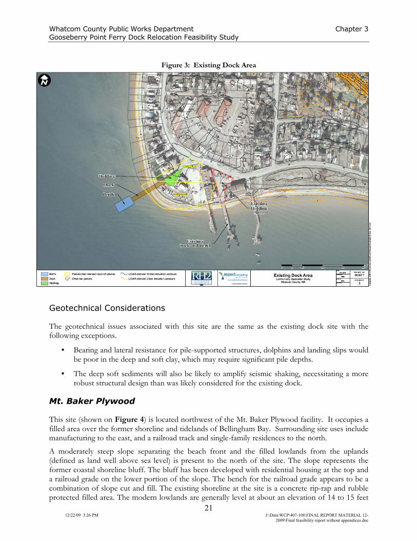
Chapter 3: Task 103 − Geotechnical Considerations
Four preferred alternative sites have been developed from a longer list of potential sites. The locations of the existing dock and four preferred alternatives (the sites) are shown on Figure 1. These include a site on the reservation near the existing dock (west of existing dock – shown on Figure 2), and three more distant sites in Bellingham Bay. Bellingham Bay sites include one west of the Mt. Baker Plywood facility (Mt. Baker Plywood – shown on Figure 3); a site in the Hilton Harbor Waterway (Hilton Harbor – shown on Figure 4); and the Whatcom Waterway with possible sites on the northeast side of the waterway (Whatcom Waterway East – shown on Figure 5) and the southwestern portion (Whatcom Waterway West – shown on Figure 5).
The sites and their associated geotechnical considerations are discussed below, along with a discussion of the existing site which forms the baseline condition for relative geotechnical ranking. A geotechnical considerations and complexity ranking of the sites relative to the existing site is presented in Table 3 in the Conclusions section of this chapter.
Existing Dock
The existing dock site (Figure 3) occupies a developed lowland used for Lummi Nation community businesses and activities, light industry, fisheries processors and other uses. Residential housing is present several hundred feet to the northeast.

Whatcom County Public Works Department Chapter 3
Gooseberry Point Ferry Dock Relocation Feasibility Study
19 12/22/09 3:26 PM J:\Data\WCP\407-108\FINAL REPORT MATERIAL 12-
2009\Final feasibility report without appendices.doc
Figure 2: Site Alternatives Vicinity Map
The low-lying site area (lowland refers to land that is natural or filled and is above modern high-tide limits) is a beach bar that lies at about elevation 10 feet (North American Vertical Datum, 1988). The bar has accreted along the northeastern side of Hale Passage since sea level stabilized around 5,000 years ago following the last glaciation. The bar is about 1,300 feet wide, with the widest point of the bar located at Gooseberry Point, about 300 to 400 feet west of the existing dock. The bar is composed of sand and gravel that was transported by longshore drift cells moving sediment along the beach and toward the point from the east and north.
The low-lying lands north and east of the site are also composed chiefly of sand and gravel beach sediment. This kind of depositional environment often includes areas with wetlands or salt marshes, and may have deposits of wetland soils, including peat, wood, logs, and layers of sand and gravel. If wetland areas were present, they appear to have been filled during development of the area. Groundwater is anticipated to lie within several feet of the ground surface.
As long as sediment is still being supplied to the shoreline from existing beaches and feeder bluffs over the life of the project, the spit is expected to remain generally stable or continue to accrete slowly. In any given year, storms may cause noticeable beach erosion and storm surges may flood the upland. Erosion and steepening of the beach generally occurs during stormy winter months, and accretion during calmer summer months. If future construction of shoreline protection measures occurs along beaches and feeder bluffs, the beach may generally tend to erode or steepen over time.
The beach deposits at the existing ferry terminal were explored by HWA Geosciences in 2006 (HWA, 2006) for a dock repair and improvements program. Three borings were completed in the

Whatcom County Public Works Department Chapter 3
Gooseberry Point Ferry Dock Relocation Feasibility Study
20 12/22/09 3:26 PM J:\Data\WCP\407-108\FINAL REPORT MATERIAL 12-
2009\Final feasibility report without appendices.doc
waters seaward of the existing dock, generally offshore of the modern beach deposits. The borings generally encountered Holocene marine deposits consisting of loose silty sand and very soft to soft clays. These clays were noted to range from 37 feet to over 76 feet thick (measured below mudline). Very dense to hard (glacially overridden) glacial deposits were encountered below the beach sediments and soft glacio-marine deposits in several of the borings. Depth to bedrock was not determined at this site.
Geotechnical Considerations
Geotechnical issues associated with the existing dock site include the following.
• Beach deposits in potential parking/holding areas of the lowlands may be weak and prone to settlement due to buried organic soils. Settlement may occur when additional loads are applied. Loads in road and parking areas are not anticipated to be high. Areas with concentrated loads may require deep foundations or designs to accommodate weak subgrade soils and low bearing pressures.
• Beach deposits in the lowlands and existing beach may be liquefiable during seismic events due to the combination of loose sandy soils and shallow groundwater. Ground settlement, loss of bearing support, and sand boils and ponding from fluid escape can occur with liquefaction.
• Sediment transport is active at this site due to swift currents along the shoreline and exposure to storm-generated waves. Beach conditions may change seasonally and the beach may erode or accrete over time. Accretion may cause shallowing of the waters in the dock area, which could require periodic deepening of the dock area by dredging or extending the dock seaward to a greater water depth.
• Subsurface conditions in the offshore dock area include soft clay to considerable depths.
West of Existing Dock
This site is located about 200 feet west of the existing dock site (Figure 3). It is currently used for vehicle, boat, and equipment parking and storage, with vehicle access to the beach for boat launching. The general characteristics of the site are the same as the existing dock site, with the exception that it is closer to the point of the beach bar and there are single-family residences adjacent to the west.
Whatcom County Public Works Department Chapter 3
Gooseberry Point Ferry Dock Relocation Feasibility Study
21 12/22/09 3:26 PM J:\Data\WCP\407-108\FINAL REPORT MATERIAL 12-
2009\Final feasibility report without appendices.doc
Figure 3: Existing Dock Area
Geotechnical Considerations
The geotechnical issues associated with this site are the same as the existing dock site with the following exceptions.
• Bearing and lateral resistance for pile-supported structures, dolphins and landing slips would be poor in the deep and soft clay, which may require significant pile depths.
• The deep soft sediments will also be likely to amplify seismic shaking, necessitating a more robust structural design than was likely considered for the existing dock.
Mt. Baker Plywood
This site (shown on Figure 4) is located northwest of the Mt. Baker Plywood facility. It occupies a filled area over the former shoreline and tidelands of Bellingham Bay. Surrounding site uses include manufacturing to the east, and a railroad track and single-family residences to the north.
A moderately steep slope separating the beach front and the filled lowlands from the uplands (defined as land well above sea level) is present to the north of the site. The slope represents the former coastal shoreline bluff. The bluff has been developed with residential housing at the top and a railroad grade on the lower portion of the slope. The bench for the railroad grade appears to be a combination of slope cut and fill. The existing shoreline at the site is a concrete rip-rap and rubble protected filled area. The modern lowlands are generally level at about an elevation of 14 to 15 feet

Whatcom County Public Works Department Chapter 3
Gooseberry Point Ferry Dock Relocation Feasibility Study
22 12/22/09 3:26 PM J:\Data\WCP\407-108\FINAL REPORT MATERIAL 12-
2009\Final feasibility report without appendices.doc
(several feet above extreme high tide height), and are currently used for public parking and traffic around the plywood facility.
The tidelands are very shallow (NOAA, 2006) and the marine waters appear to generally lack strong currents. Therefore, these are considered to be low-energy waters and will have loose and/or soft fine grained clay, mud and sandy sediments. A pile-supported dock to the northwest of the site extends about 2,000 feet into the tidelands where the bay is deep enough for vessel docking.
Geotechnical Considerations
• Although no indications of significant instability were noted, the steep slopes north of the site may present stability concerns. The presence of a railroad embankment on the lower slope suggests that the toe of the slope has been buttressed and stabilized, either by rip-rap placed by the railroad, or by filling of the shoreline and former tidelands. Erosion at the toe of the bluff has been eliminated, providing increased slope stability. Seismic slope hazards may remain.
• The filled former tidelands may present liquefaction hazards as described for the existing dock. Soft and saturated sandy mud below the fill may be liquefiable, which could cause settlement and loss of support for structures.
• The bay is shallow, which will require either a long pile-supported dock or a filled causeway to reach waters deep enough for ferry loading. Alternatively, extensive dredging could be required to deepen the waterway and reduce dock length.
• Soft Holocene marine clay and/or Bellingham drift (soft glaciomarine clay) are anticipated to be present in this area, which may require long piles to obtain adequate bearing.
• Design of a filled causeway would need to consider the compressible bay sediments. Staged fill or preloads would be necessary to avoid bearing failures.
• The deep soft sediments will also likely amplify seismic shaking, necessitating more robust structural design than was likely considered for the older existing docks in the area.
• The site area has an extensive industrial history. Although no environmental contaminant hazards are known, they may exist, and removal of existing soils could necessitate special disposal.
Whatcom County Public Works Department Chapter 3
Gooseberry Point Ferry Dock Relocation Feasibility Study
23 12/22/09 3:26 PM J:\Data\WCP\407-108\FINAL REPORT MATERIAL 12-
2009\Final feasibility report without appendices.doc
• The filled lowlands and shoreline area likely contain uncontrolled fill (that which was not placed in a controlled manner designed to provide support for structures), which may require subgrade improvement and/or deep foundations for settlement sensitive structures.
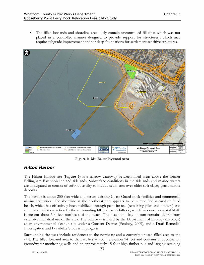
Figure 4: Mt. Baker Plywood Area
Hilton Harbor
The Hilton Harbor site (Figure 5) is a narrow waterway between filled areas above the former Bellingham Bay shoreline and tidelands. Subsurface conditions in the tidelands and marine waters are anticipated to consist of soft/loose silty to muddy sediments over older soft clayey glaciomarine deposits.
The harbor is about 250 feet wide and serves existing Coast Guard dock facilities and commercial marine industries. The shoreline at the northeast end appears to be a modified natural or filled beach, which has effectively been stabilized through past site use (remaining piles and timbers) and elimination of wave action by the surrounding filled areas. A hillside, which was once a coastal bluff, is present about 500 feet northeast of the beach. The beach and bay bottom contains debris from extensive industrial use of the area. The waterway is listed by the Department of Ecology (Ecology) as an environmental cleanup site under a Consent Decree (Ecology, 2009), and a Draft Remedial Investigation and Feasibility Study is in progress.
Surrounding site uses include residences to the northeast and a currently unused filled area to the east. The filled lowland area to the east lies at about elevation 14 feet and contains environmental groundwater monitoring wells and an approximately 15-foot-high timber pile and lagging retaining

Whatcom County Public Works Department Chapter 3
Gooseberry Point Ferry Dock Relocation Feasibility Study
24 12/22/09 3:26 PM J:\Data\WCP\407-108\FINAL REPORT MATERIAL 12-
2009\Final feasibility report without appendices.doc
wall. The wall is tipping and appears to be failing in places. The filled area to the northwest of the harbor is protected from erosion by a rip-rap shoreline revetment, and appears stable.
Geotechnical Considerations
• The retaining wall that forms the southeastern side of the harbor is failing. Before a new dock and terminal could be placed in this area, the wall would need repairs or replacement, or the fill behind the wall would need to be re-graded to a stable angle and the face protected from erosion.
• The remaining shoreline at the northeast end of the harbor is not protected from erosion. Vessel prop wash could create erosion hazards that could require shoreline stabilization or other mitigation.
• The tidelands are shallow and slope gently into the bay. A dock would need to extend out far enough to obtain the depth necessary for ferry operations, necessitating a pile supported structure or causeway. Alternatively, dredging could be required to deepen the waterway and reduce the length of the dock.
• The filled former beach and tidelands may present liquefaction hazards. Loose and saturated sandy soils may be present and liquefiable, which could cause settlement and loss of support for structures.
• The deep soft sediments will also likely amplify seismic shaking, necessitating more robust structural design than was likely considered for older existing docks in the area.
• The filled upland and shoreline areas likely contain uncontrolled fill, which may require subgrade improvement or deep foundations for settlement sensitive structures.
• The site has an extensive history of industrial use and is listed by Ecology as a cleanup site. Any operation disturbing existing site soils, sediment or groundwater may require special analysis, testing, design, construction, monitoring and material disposal.

Whatcom County Public Works Department Chapter 3
Gooseberry Point Ferry Dock Relocation Feasibility Study
25 12/22/09 3:26 PM J:\Data\WCP\407-108\FINAL REPORT MATERIAL 12-
2009\Final feasibility report without appendices.doc
Figure 5: Hilton Harbor Area
Whatcom Waterway
The Whatcom Waterway site (Figure 6) is about 400 feet wide and was created by filling tidelands and shoreline on either side of the mouth of Whatcom Creek.
The inner reach of the waterway (seaward of the Roeder Avenue Bridge) is bounded to the southeast by shallow tidelands and beaches with seawalls and overhead piers. The northwest side of the waterway is used for small boat moorage and repair facilities. Structures along the waterway are supported on piles and filled areas behind rip-rap revetments. The southeast bank of the waterway is occupied by the Georgia Pacific paper mill site and a shipping container loading and handling facility. Lowlands at this site consist of filled tidelands lying at about elevation 12 to 14 feet.
Surrounding land use is predominantly industrial. The Whatcom Waterway has been identified as a cleanup site by Ecology with sites including the Georgia Pacific paper mill to the southeast and the Holly Street landfill to the north. Site investigations have been completed and the cleanup is in the design and permitting phase.
Two potential terminal sites are present in this waterway: 1) near the northeast end of the waterway, by the Georgia-Pacific site (Whatcom Waterway East); and 2) on the northwestern side of the waterway near the southeast corner of the main fill area (Whatcom Waterway West). Subsurface conditions in the lowlands of both sites are anticipated to consist of fill in the lowlands placed over tidelands and shallow marine bay mud. Outside of the filled areas, natural deposits in the tidelands and marine waters are anticipated to consist of soft/loose silty to muddy sediments over older soft clayey glaciomarine deposits. The northern site consists of a beach covered by pile-supported buildings, areas of exposed beach and tidelands with stubs of old piles, and filled uplands separated

Whatcom County Public Works Department Chapter 3
Gooseberry Point Ferry Dock Relocation Feasibility Study
26 12/22/09 3:26 PM J:\Data\WCP\407-108\FINAL REPORT MATERIAL 12-
2009\Final feasibility report without appendices.doc
from the beach by a low seawall. The southern site is a filled area with rip-rap shoreline protection and a gap in the rip-rap that is currently used for access to a man-made gravel beach.
Geotechnical Considerations
• The pile-supported structures over the tidelands at the northern site and the existing seawalls are of unknown age and condition. Existing docks and buildings would likely need removal, or repair or replacement before constructing a new terminal.
• The remaining shoreline at the northeast end of the waterway is not protected from erosion. Vessel prop wash could create erosion hazards that could require shoreline stabilization or other mitigation.
• The tidelands are shallow and slope gently into the bay. A dock at the southern site would need to extend far enough to obtain the depth necessary for ferry operations. Alternatively, dredging could be required to deepen the waterway and reduce the length of the dock. The northern site likely deepens more quickly and is less likely to require a long dock or dredging to develop adequate vessel depth.
• The filled former beach and tidelands may present liquefaction hazards. Loose and saturated sandy soils may be present and liquefiable, which could cause settlement and loss of support for structures.
• The deep soft sediments will also likely amplify seismic shaking, necessitating more robust structural design than was likely considered for the older existing docks in the area.
• The filled upland and shoreline areas likely contain uncontrolled fill, which may require subgrade improvement or deep foundations for settlement sensitive structures.
• The waterway and Georgia Pacific site have an extensive history of industrial use and is listed by Ecology as a cleanup site. Any operation disturbing existing site soils, sediment or groundwater may require special analysis, testing, design, construction, monitoring and material disposal.

Whatcom County Public Works Department Chapter 3
Gooseberry Point Ferry Dock Relocation Feasibility Study
27 12/22/09 3:26 PM J:\Data\WCP\407-108\FINAL REPORT MATERIAL 12-
2009\Final feasibility report without appendices.doc
Figure 6: Whatcom Waterway
Conclusions
Each site presents different geotechnical considerations. A summary of the geotechnical considerations and ranking relative to the existing site is included in Table 3. The existing dock site is assigned a ranking of 0 and other sites are ranked up or down (+ or -) from 0 to 2 with regard to the geotechnical complexity compared to the existing site. The geotechnical complexity assumes that any new structure would be built to modern geotechnical code and standards. Based on the considerations, the west of existing dock site is ranked a 0 and the three Bellingham Bay sites are ranked -1 to -2.
Limitations
Work for this project was performed and this Study prepared in accordance with generally accepted professional practices for the nature and conditions of work completed in the same or similar localities, at the time the work was performed. It is intended for the exclusive use of RH2 Engineering, Inc. and Whatcom County for specific application to the Lummi Ferry Relocation Study project. This Study does not represent a legal opinion. No other warranty, expressed or implied, is made.
This Study is issued with the understanding that the information and conclusions contained herein are the results of a reconnaissance site visit only. No subsurface explorations were conducted and the conclusions are not intended to be used for design purposes.

Whatcom County Public Works Department Chapter 3
Gooseberry Point Ferry Dock Relocation Feasibility Study
28 12/22/09 3:26 PM J:\Data\WCP\407-108\FINAL REPORT MATERIAL 12-
2009\Final feasibility report without appendices.doc
The scope of work did not include research and review of existing geotechnical records at these sites, other than those provided by other team members, environmental assessments, or evaluations regarding the presence or absence of hazardous substances in the soil, surface water or groundwater at these sites.

Whatcom County Public Works Department Chapter 3
Lummi Gooseberry Ferry Dock Relocation Feasibility Study
29 12/22/09 3:26 PM J:\Data\WCP\407-108\FINAL REPORT MATERIAL 12-2009\Final feasibility report without
appendices.doc
Table 3: Geotechnical Considerations and Ranking
Site Name SettingUplands Geotechnical
Considerations
Shoreline
Geotechnical
Considerations
Marine Geotechnical
Considerations
Environmental
Hazards
Other
Considerations
Geotechnical
Ranking
Existing Dock
Natural beach
environment. Holding
area on accreted back
beach bar and possible
filled wetland.
Dock/ramp on gently
sloping gravel and sand
beach.
Shallow groundwater.
Potentially liquefiable
and compressible soils.
Potentially prone to
storm surge flooding.
Longshore transport
environment. Beach
generally stable to
accreting. High beach
stabilized with concrete
rubble and transient
logs.
Swift currents, potential
eelgrass and fish
habitat. Shallow
bottom. Soft
glaciomarine clay below
surficial beach deposits.
None known. Nearby
boat maintenance and
fish processing
facilities.
0
West of Existing Dock Same as above. Same as above.
Same as above with
exception that some of
shoreline is a boat
launch area without
existing shoreline
erosion protection,
which would be
required.
Same as above.
None known. Nearby
boat maintenance and
fish processing
facilities.
Near residences. 0
Mt. Baker Plywood
Natural and modified
area. Holding on filled
area over beach and
tidelands. Dock and
ramp over shallow mud
bay adjacent to filled
area.
Steep slopes above
shoreline. Slope
buttressed by railroad
grade and shoreline
stabilization. Low risk of
seismic slope
instability. Parking on
filled area - potential
settlement or
liquefaction hazards,
weak soils.
Stable shoreline
protected with rip-rap.
Shallow bottom. Low
energy, slow current.
Requires dredging or
long pile supported
dock, possible
eelgrass.
None known. Site area
has history of industrial
use. Dredge spoils may
require special disposal.
Near residences.
Long dock or
dredging required.
-1
Hilton Harbor
Natural and modified
area. Holding on filled
area over beach and
tidelands. Dock and
ramp over shallow mud
bay in narrow waterway
adjacent to filled area.
Parking on filled area -
potentially liquefiable
and compressible/weak
soils.
Stable, low energy.
May require
stabilization for
mitigation of prop wash.
Soft tidelands and mud,
shallow bottom,
dredging possible.
Site identified by
Ecology as I&J
Waterway, subject to
Consent Decree
cleanup. Industrial
debris on tidelands.
-2
Whatcom Waterway
East
Natural and modified
area. Holding on filled
area over beach and
tidelands. Dock and
ramp over shallow mud
bay in narrow waterway
adjacent to filled area.
Parking on filled area -
potentially liquefiable
and compressible/weak
soils.
Low energy shoreline,
low seawall on
shoreline, old and
existing timber piles in
beach.
Soft tidelands and mud,
shallow bottom,
dredging possible.
Ecology cleanup area.
Adjacent to Georgia
Pacific and Holly Street
Landfill sites.
-2
Whatcom Waterway
West
Fill modified area.
Holding on filled area
over tidelands. Dock
and ramp over shallow
mud bay in narrow
waterway adjacent to
filled area.
Parking on filled area -
potentially liquefiable
and compressible/weak
soils.
Artificial beach, fill soils
on tidelands, rip-rap
protected shoreline.
Soft tidelands and mud,
shallow bottom,
dredging possible.
Ecology cleanup area.
Adjacent to Georgia
Pacific and Holly Street
Landfill sites.
-1

Whatcom County Public Works Department Chapter 4
Gooseberry Point Ferry Dock Relocation Feasibility Study
30
12/22/09 3:26 PM J:\Data\WCP\407-108\FINAL REPORT MATERIAL 12-2009\Final
feasibility report without appendices.doc
Chapter 4: Task 103 − Cultural Resource Considerations
Northwest Archaeological Associates, Inc. (NWAA) provided the cultural resources assessment for this Study. This assessment provides background information on the natural and cultural setting of the project area. It also describes the study methods used to assess the sensitivity for cultural material at each alternative site, provides the results of the study, and gives recommendations based on those results. All four of the alternative locations are sensitive for Native American archaeological material. The three alternatives on Bellingham Bay are also sensitive for archaeological material related to the historic maritime and commercial development of the shoreline.
Regulatory Context
The National Historic Preservation Act (NHPA) provides the standards and regulatory context for this Study, as the project may be funded by both state and federal monies and will require federal permits related to shoreline use. The NHPA, as amended, requires that federal agencies identify and assess the effects of federally assisted undertakings on cultural resources and consultation with others to find acceptable ways to avoid or mitigate adverse effects. Resources protected under Section 106 of the NHPA are those that are listed or eligible for listing on the National Register of Historic Places. Eligible properties generally must be at least 50 years old, possess integrity of physical characteristics and meet at least one of four criteria of significance.
The project may also be subject to Washington State laws regarding cultural resources. The Archaeological Sites and Resources Act [Chapter 27.53 RCW] prohibits knowingly excavating or disturbing pre-contact and historical archaeological sites on public or private land without a permit from the Washington Department of Archaeology and Historic Preservation (DAHP). The Indian Graves and Records Act [Chapter 27.44 RCW] prohibits knowingly destroying American Indian graves and requires any inadvertent disturbance by construction or other activity to be followed by re-internment under supervision of the appropriate Indian tribe. Additionally, RCW 42.56.300 states that records, maps or other information identifying the location of archaeological sites are exempt from disclosure to avoid the looting or depredation of such sites.
Tribal Coordination
Prior to field investigations, NWAA contacted the Lummi Indian Nation to inquire about information and concerns the tribe may have pertaining to cultural resources in or near the alternative locations. A copy of this correspondence is included in Appendix D. The Lummi Nation responded to the letter, requesting that NWAA attend a cultural orientation. NWAA representatives, along with Mr. Jim Bucknell, Project Manager for RH2 Engineering, Inc., attended the orientation session. The tribal members also requested they be included in discussions during all phases of the Study.
On March 26, 2008, Ms. Christian Miss and Ms. Brandy Rinck of NWAA met with the Schelangen Department of the Lummi Indian Business Council to request that NWAA be listed on their preferred cultural resource management firm list. They were accepted as representatives of NWAA after an orientation conducted by the Lummi Cultural Department on September 25, 2008.
All project updates between September 2008 and now were forwarded to Ms. Lena Tso, the Lummi Tribal Historic Preservation Officer (THPO) by Ms. Brandy Rinck of NWAA. Mr. Jim Perkins of Whatcom County (County) also worked to ensure the Lummi Indian Nation was informed of new

Whatcom County Public Works Department Chapter 4
Gooseberry Point Ferry Dock Relocation Feasibility Study
31 12/22/09 3:26 PM J:\Data\WCP\407-108\FINAL REPORT MATERIAL 12-
2009\Final feasibility report without appendices.doc
decisions during each of the project’s phases and that any concerns they may have had about the project were heard along the way. The final four alternative locations were sent to the Lummi THPO by e-mail on September 3, 2009. No comment has been received from the Lummi Nation to date.
Project Setting
The end of the Pleistocene corresponds to glacial retreat in North America and marks the beginning of modern landscape, climate and vegetation evolution (Thorson, 1989). Sea level rise, climate change and tectonic activity have been the dominant forces of environmental change since the end of the Pleistocene, affecting the kinds of resources available to ancient people, the distribution of those resources and the suitability of particular landforms for occupation. These environmental changes have also affected the preservation and visibility of the archaeological record. Archaeological evidence indicates that people were living in what is now Washington approximately 10,000 years before present (BP), and possibly earlier (Carlson, 1990). Ethnographic and historic records provide complementary information about more recent cultural land use practices. Environmental diversity and a variety of natural resources concentrated in the project vicinity created an ideal location for both pre-contact and early Euroamerican populations. In depth details concerning the environmental and cultural setting of the project area can be found in Appendix D. RCW 42.56.300 states that records, maps, or other information identifying the location of archaeological sites are exempt from disclosure in order to avoid the looting or depredation of such sites.
This chapter includes all of the necessary information without violating RCW 42.56.300. A copy of the Cultural Resources Assessment is available at the Department of Archaeology and Historic Preservation in Olympia, Washington. Limited copies of this report (for Whatcom County and the Lummi Nation) include a copy of this Cultural Resources Assessment as Appendix D.
Methods
Archival research was completed prior to reconnaissance to verify field conditions. Washington State site inventory, records and previous cultural resources investigations at the DAHP were checked to identify sites that were previously recorded in the project vicinity, as well as to obtain copies of reports that document earlier investigations. Ethnographic and historical accounts, maps, photographs and environmental sources were also reviewed in the NWAA library.
Previous Research
Archaeological remnants of the original Native American occupation at Gooseberry Point and later Euroamerican settlement have been found very close to the project area. A records check at the DAHP indicated that 33 archaeological investigations have been conducted around Gooseberry Point in conjunction with private development, utilities installation, and as part of cultural resource inventory surveys by the Washington State Parks Department. Many of the cultural resources reports revisited sites that were first recorded in the 1970s and 1980s as the area was developed. The results of these and other surveys have identified 13 sites, ranging from shell middens (some with human remains) to sparse lithic scatters and historic sites in the vicinity of Gooseberry Point.

Whatcom County Public Works Department Chapter 4
Gooseberry Point Ferry Dock Relocation Feasibility Study
32 12/22/09 3:26 PM J:\Data\WCP\407-108\FINAL REPORT MATERIAL 12-
2009\Final feasibility report without appendices.doc
A number of these sites are in the immediate vicinity of the west of existing dock alternative (Appendix D).
The records checks at the DAHP also indicated that 24 reports have been completed within 1 mile of the three ferry dock alternatives in Bellingham. Projects were conducted for creosote removal in Bellingham Bay, many trail and road improvement projects in the area, a rail corridor, a housing project, a private residence and a gas pipeline. Six archaeological sites and 12 historic properties were recorded and revisited during the investigations. Cultural overview studies of the Bellingham vicinity were also completed for Bellingham Bay and Squalicum Harbor, as well as for the Whatcom Waterway redevelopment project. These studies discussed the potential for archaeological materials in the surrounding area and the results of cultural resources surveys and monitoring. A history of the shoreline alterations at Whatcom Creek was also prepared and an illustrated inventory of the historic buildings was completed (Appendix D).
Expectations
Previously recorded cultural resources and a rich ethnographic record indicate there is a high probability for encountering prehistoric or historic Native American cultural resources at each of the ferry dock alternative locations. Ancient peoples would have inhabited the shorelines and back-bay areas, especially where slopes graded gently down to the water’s edge (i.e. at Gooseberry Point or at creek mouths in Bellingham Bay). Native American winter villages would be identified by fire pits, fire-modified rock (FMR), shell middens, structural remains, posts, rectangular pits and cemeteries. Temporary campsites would be along trails between resources and villages, as well as near gathering areas for berries, cattails and other plant resources. These types of resources are buried below asphalt at Gooseberry Point. They would also be buried under fill below the wharves in Bellingham, if present. Based on the distribution of previously recorded sites in the area, potential for pre-contact archaeological resources is highest along the coast at stream mouths. Sites have also been identified on terraces above the beach near Bellingham. While similar sites have not been identified along the historic beach in Bellingham, it is likely that such sites exist but are buried below fill and could be disturbed if excavation were to occur.
The potential for finding historic archaeological resources at each of the ferry dock alternatives varies. For example, the potential for finding historic resources at Gooseberry Point is low because the site was not historically developed. The potential for significant historic properties in Bellingham is much higher. The cultural resources buried by and within fill in Bellingham Bay could include items associated with early settlement and industry around Bellingham Bay, such as bottles, cans, machine parts, remnant pilings or domestic items littered along the shoreline. They may also be more specifically related to the industries discussed in the history section (logging, canning, shipping). The potential exists for the identification of both single artifacts and occupational surfaces with many artifacts, buried structural remains and/or debris.
Based on historic maps and photographs, the earliest historic materials were buried along the southeast shore of Bellingham Bay. As the city grew westward and the wharves increased in length and size, these early historic materials were either incorporated into the new construction, removed or buried. Historic buildings, bridges and trestles have been previously identified near the potential ferry dock locations, and it is expected that some of the buildings located on the wharves are historic.

Whatcom County Public Works Department Chapter 4
Gooseberry Point Ferry Dock Relocation Feasibility Study
33 12/22/09 3:26 PM J:\Data\WCP\407-108\FINAL REPORT MATERIAL 12-
2009\Final feasibility report without appendices.doc
Recommendations
Further cultural resources investigations would be recommended for any of the final alternatives chosen as a ferry dock location. The purpose of the investigations would be to identify new historic properties and determine the extent, content and condition of any recorded or newly discovered archaeological material potentially intersected by the project. This information can be used to make design adjustments to avoid impacts and develop mitigation measures for those impacts that cannot be avoided. Impacts to the integrity of any historic buildings that may be present would also be determined by specific construction plans, and an effort can be made during planning stages to avoid adverse effects.
If federal funds are used or federal permits are required, then this work would be undertaken following regulations for implementation of the National Historic Preservation Act (36 CFR 800). These regulations clearly outline requirements for identification and evaluation of historic properties, tribal consultation and public involvement, and development of agreement documents. In each instance, specific construction designs would help to shape archaeological investigations. Initial recommendations upon discovery of cultural materials would attempt to avoid disturbance by re-design, with the understanding that mitigation in the form of data recovery is generally expensive and time consuming. Initial investigations would involve subsurface exploration using backhoe trenches and/or geotechnical cores, as well as a survey of the surrounding buildings. Estimated cost for NWAA to conduct this preliminary work would range from $12,000 to $18,000, exclusive of specialized excavation or sampling equipment.
Among the alternatives, the west of existing dock alternative is ranked the most sensitive without additional investigation because of the recorded pre-contact archaeological site at Gooseberry Point. Alternatives on Bellingham Bay are most sensitive for Native American sites when close to a stream mouth, such as at Mt. Baker Plywood and Whatcom Waterway South. Concern for historic artifacts is greatest at the Hilton Harbor and Whatcom Waterway alternatives, where facilities are built on existing wharfs or decking. The concern is somewhat mitigated by positioning on dredged waterways. The Mt. Baker Plywood alternative is judged to have the lowest potential for historic material because of its position below a steep bluff and the anticipated extent of the dock into the bay. Nonetheless, as discussed above, additional investigation would be necessary to verify conditions.
Whatcom County Public Works Department Chapter 5
Gooseberry Point Ferry Dock Relocation Feasibility Study
34
12/22/09 3:26 PM J:\Data\WCP\407-108\FINAL REPORT MATERIAL 12-2009\Final
feasibility report without appendices.doc
Chapter 5: Task 103 − Engineering and Navigation Issues
Any marine dock facility has a number of associated potential engineering and navigation issues. The existing ferry dock at Gooseberry Point is no exception. The existing run, which consists of the Whatcom Chief and terminals at both Lummi Island and Gooseberry Point, has a discrete set of conditions that affect the overall operation of the ferry.
Similarly, any new dock location will also have its own set of such issues. Some of these may be very similar, or even identical to, to those at the existing dock, while others may be quite different and unique to a given location. This chapter provides an overview of these issues as they relate to the alternative sites that are being evaluated under Tasks 103 and 104: west of existing dock; Hilton Harbor; Whatcom Waterway (both locations); Mt. Baker Plywood; and the existing location.
Potential Engineering Issues
A typical ferry dock consists of a number of component parts, the number and size of which are dependent upon the specific characteristics of the site. The typical major components are as follows.
• Trestle: The trestle is essentially the pier structure that extends from the shore to the point where the ferry docks and the vehicles are loaded and off loaded.
• Bulkhead: This is the landside wall to which the trestle is connected at the shoreline.
• Bridge Seat: This the last pile bent that is reinforced to support the trestle and the pivoting transfer span.
• Bridge or Transfer Span: This is the moveable part of the dock that connects the trestle, where it bears on the bridge seat, to the ferry dock and which traffic crosses as it boards and leaves the ferry boat.
• Wing Walls: These are the walls immediately adjacent to the trestle that help guide the boat into the dock and also help keep it "captured" if big winds or currents are encountered. Typically, as the vessel is docked, it needs to be pushed into the wing walls to keep from drifting. The wing walls keep the bow of the vessel connected to the transfer span as long as the engines are running on low. Otherwise, the tides and currents can shift the vessel out of the berthing slip.
• Dolphins: These help guide the ship into the slip. They give before the vessel gives. They are essentially sacrificial bumpers and the ship captains use them as visual guides and physical guides on occasion. Old dolphins were typically clusters (up to 100 at Washington State ferry terminals) of creosote treated timbers. Newer ones are constructed of steel.
Washington State ferries has four types of dolphins: inner, intermediate, outer and floating. Inner dolphins are the smallest and withstand the least energy. They are positioned close to the wing walls. Floating dolphins are used when the seafloor is rocky or the shoreline dives down rapidly, resulting in deep water close to shore. During storm events, the vessels occasionally miss the berthing slip due to strong currents, water turbulence and wind. In these instances, the dolphins are intended to stop the vessel from crashing into adjacent vessels, marinas or piers.

Whatcom County Public Works Department Chapter 5
Gooseberry Point Ferry Dock Relocation Feasibility Study
35 12/22/09 3:26 PM J:\Data\WCP\407-108\FINAL REPORT MATERIAL 12-
2009\Final feasibility report without appendices.doc
In addition to these major components, the construction of a dock facility also includes other materials such as structural steel, pilings, anchors, deck seal, concrete, treated and untreated timbers, chains, shackles, wire rope, railings and lighting, as well as costs related to dredging and disposing of materials.
The mix and sizing of components depends on the specifics of the dock location in terms of a number of factors, including the land surface elevation compared to the water elevation; the depth of water and the degree to which a long trestle or dredging may be required; the exposure to wind and currents and the size and number of wing walls and dolphins required; the size of the boat, etc.
Existing Dock and Location West of Existing Dock
The existing structures at the Gooseberry Point terminal include a transfer span, a tower, right and left wing walls, and four dolphins (two left and two right). The dock is approximately 240 feet long and 17 feet wide.
Each side of the tower is supported by four steel pipe piles. The wing walls and dolphins all consist of timber piles (Art Anderson and Associates, 2006).
The land and facilities in the vicinity of the existing Gooseberry Point ferry dock are subject to occasional coastal flooding during high tide and southerly wind events. If predicted rises in sea level occur, these problems will happen more regularly and will likely be more severe than under present conditions.
In addition, Gooseberry Point is mapped as a tsunami inundation area in the event of a major (Magnitude 9.1) off-shore earthquake along the Cascadia Subduction Zone such as the one believed to have occurred in January 1700 (Satake et al., 1996).
The National Oceanic and Atmospheric Administration (NOAA) operated a tidal station at Gooseberry Point from 1960 to 1978. Based on tidal records at that station, the highest observed water level was 9.98 feet above mean lower low water. The mean higher high water was 8.83 feet and the mean low water was 2.48 feet above mean lower low water. The data indicate that the tidal range is less than in lower Puget Sound, and the median water level is well above the mean lower low water level. As a result, the lowest tides are relatively high which is beneficial for navigation. (Source: http://tidesandcurrents.noaa.gov/benchmarks/benchmarks_old/9449184.html.)
The closest official weather station is located at the Bellingham International Airport about 6 miles east of Gooseberry Point. At the airport, average winds for a 6-year period ending in August 2004, were 7.4 miles per hour (mph) from the southeast. At Gooseberry Point, the greatest fetch is 27 miles but the fetch from the most common wind direction is 14 miles. The potential new location west of the existing dock would likely not result in a significant change in terms of wind or current; however, prevailing winds/waves would probably be more perpendicular to the pier, which is less favorable for navigation.
The Whatcom County area is frequently subject to significant storm events, and any new ferry route and its ancillary facilities must be designed with these events in mind.
According to records of the NOAA’s National Climate Data Center, Whatcom County has experienced 33 thunderstorm and high wind events in the period from January 1, 1950 through May 31, 2009. Wind velocities in these storms ranged from 45 mph to 89 mph. (Source: http://www4.ncdc.noaa.gov/cgi-win/wwcgi.dll?wwevent~storms)

Whatcom County Public Works Department Chapter 5
Gooseberry Point Ferry Dock Relocation Feasibility Study
36 12/22/09 3:26 PM J:\Data\WCP\407-108\FINAL REPORT MATERIAL 12-
2009\Final feasibility report without appendices.doc
Currents in Hale Passage typically range from 1 to 2 knots in velocity during both ebb and flow periods.
At the site west of the existing dock, the land elevation is similar to that of the existing dock; therefore, a similar dock structure could be constructed that would result in a relatively flat approach to the ferry. The geotechnical conditions associated with this site are discussed in Chapter 3.
Downtown Bellingham Sites (Hilton Harbor, Whatcom Waterway, Mt.
Baker Plywood)
The tsunami inundation model referenced above does not show significant inundation at the Port of Bellingham. However, tsunami amplitudes near the Port’s facilities are virtually the same as the seawall height, which makes the Port a potentially hazardous zone during the tsunami. (Source: http://www.pmel.noaa.gov/pubs/PDF/vent2713/vent2713.pdf)
The waters of Bellingham Bay are more sheltered from the predominant winds that blow from the southeast. Because of the configuration of the coast line, the fetch in Bellingham Bay is much less than the fetch in Lummi Bay. However, a ferry crossing from Lummi Island to any of the sites in Bellingham Bay would have a longer crossing time, which translates to less frequent arrivals and departures. In addition, a ferry on this route would be subject to greater winds and currents than the present route and would, at times, be travelling perpendicular to the prevailing winds and currents. Because of the need to cross a larger expanse of open water and the longer route, a new, larger boat would be required for any of the Bellingham Bay locations. This larger boat would require larger dock facilities at Lummi Island where the dock could either be modified or replaced depending on the specifics of the boat that was obtained for this route.
The geotechnical conditions associated with these sites are discussed in Chapter 3.
Hilton Harbor
The Hilton Harbor site is currently the location of the U.S. Coast Guard Bellingham Station, which is the northern-most station in the Coast Guard’s Thirteenth District.
This harbor runs from the southwest (Bellingham Bay) to the northeast (shoreward), and there is vacant land located along the southeast and northeast shore. This land is flat and devoid of any buildings or other obvious signs of development. The general land surface elevation is approximately 15 feet above the water surface; the ferry dock would need to be designed with this elevation difference in mind.
Given that the Coast Guard is able to access this waterway, the draft at the outer end of the harbor appears adequate for a ferry; however, the transportation lane between the Coast Guard dock on the northwest side and other moorage on the southeast side is fairly narrow. It appears that the landward end of the harbor would require dredging or an overwater structure of perhaps 300 feet to provide water of sufficient depth.
The geotechnical conditions associated with this site are discussed in Chapter 3.

Whatcom County Public Works Department Chapter 5
Gooseberry Point Ferry Dock Relocation Feasibility Study
37 12/22/09 3:26 PM J:\Data\WCP\407-108\FINAL REPORT MATERIAL 12-
2009\Final feasibility report without appendices.doc
Whatcom Waterway
The Whatcom Waterway site is located adjacent to the old Georgia Pacific pulp mill property. Potential dock sites are on the southeast side of the harbor near Roeder Avenue and at the southwest tip of the northwest side of the harbor. Both locations would likely require an over-water structure to access the ferry boat from the shore and appear to have some existing open space that could be suitable for parking.
For the location on the southeast side of the harbor, the presence of roads and structures would likely dictate that the dock includes a 90-degree bend to access the ferry. This is shown in Figure 6.
In order to estimate the cost of this facility, a minimum curb radius of 25 feet was assumed along with a road width of 30 feet. These numbers were taken from the Whatcom County Road Standards, which call for a minimum roadway width of 30 feet, a design speed of 25 mph (far in excess of speed on a ferry dock approach) and a minimum curb radius of 25 feet for minor and local accesses. The estimated cost for this facility is shown in Table 6.
The geotechnical conditions associated with this site are discussed in Chapter 3.
Mt. Baker Plywood
Potential dock sites at this location are the large vacant area located between the Mt. Baker Plywood plant and Bellingham Bay or could also include the construction of a long pier from the small park located adjacent to the plant, running in a southwesterly direction parallel to the shoreline of the existing property. It is estimated that the dock would need to be about 1,400 feet long if constructed at this location to reach water of sufficient depth and avoid the need for routine dredging.
The geotechnical conditions associated with this site are discussed in Chapter 3.
Potential Navigation Issues
Existing Dock and West of Existing Dock
Navigation issues at either of these locations are essentially the same. The west of the existing dock site appears to be somewhat more exposed to wind and, presumably, currents, but the overall route and length of the route is similar to existing conditions.
Hilton Harbor, Whatcom Waterway and Mt. Baker Plywood
The primary navigation issue associated with each of these sites is the longer crossing from Lummi Island and increased exposure to winds and currents, especially during winter storm events. The more extreme conditions would require a larger boat to ensure safety of passengers and crew during all anticipated weather conditions. In addition, because the run would be significantly longer (about six minutes each way for the present run, about one hour each way for the run to Bellingham Bay), a larger boat would be needed to maintain a similar level of service for those wishing to use the ferry. Of course, along with a larger boat comes longer loading and unloading times as well, which also decreases the number of runs per day and needs to be considered as the level of service is addressed.

Whatcom County Public Works Department Chapter 6
Gooseberry Point Ferry Dock Relocation Feasibility Study
38 12/22/09 3:26 PM J:\Data\WCP\407-108\FINAL REPORT MATERIAL 12-2009\Final
feasibility report without appendices.doc
Chapter 6: Task 103 − Economics and Planning Level Cost
Estimates
A key factor in deciding whether to relocate the Gooseberry Point Ferry Dock is the cost. Every site under consideration has its own unique conditions that will affect the overall costs of constructing a dock at that location. However, there are several more generic cost considerations that must first be understood as part of the alternatives evaluation.
If the existing dock is left in place and continues being used, the existing ferry boat can continue to provide service and the capital costs associated with constructing a new dock can be avoided. The existing dock would continue to have operations and maintenance costs, which, because of the age of the facilities, could be somewhat higher than similar costs for a new dock.
The existing boat, the Whatcom Chief, could continue to provide service between Gooseberry Point and Lummi Island until it needs to be replaced either due to age or the need for additional vehicle and passenger capacity. Whatcom County has investigated the need for a new and larger boat. In September 2004, the County conducted a survey about the desired future of the ferry service. The most frequently chosen alternative was: “Whatcom County should appreciably increase vehicle carrying capacity as Island population grows. A larger vessel or another vessel to supplement the Whatcom Chief would be required.” (Source: September 2004 Lummi Island Ferry Survey Summary)
Preliminary plans were developed for a new boat which was designed to carry 35 cars and 150 passengers compared to the Whatcom Chief’s capacity of 20 cars and 100 passengers. The estimated cost of this boat, in 2003 dollars, was approximately $10 to $12 million.
If a new, larger boat is obtained, the County would, at least, need to modify the two existing docks to accommodate the new boat.
If the Gooseberry Point Ferry Dock is moved to the location west of the existing dock, the costs would include building a new dock that can accommodate the existing boat and, perhaps, a larger boat if it appears that such a boat will be obtained in the relatively near future. This larger ferry was not designed to make the crossing to any of the locations in Bellingham Bay. The routes to Bellingham would require design and construction of an even larger ferry to provide adequate levels of safety and service.
If the Gooseberry Point Ferry Dock is moved to any of the locations in Bellingham Bay (Hilton Harbor, Whatcom Waterway or Mt. Baker Plywood), several changes would be required. First, as previously discussed, a larger boat would be required to provide safe passage over the open waters between Portage Island and Bellingham, and increased automobile and passenger capacity to counteract the longer passage times and less frequent arrivals and departures. In addition, any of the Bellingham Bay locations would require construction of a new dock facility and the size of the boat for this run would necessitate either a full replacement or a major rebuild of the existing dock on Lummi Island. For planning purposes, the rebuild of the Lummi Island dock will be treated as construction of a new dock facility. Therefore, each of the downtown Bellingham locations must include the cost of a new boat as well as the construction of two new dock facilities, one on the mainland and one on Lummi Island. In addition to the dock facilities, the longer run to Bellingham Bay would require expansion of the dedicated parking and waiting areas because of the reduced frequency of runs. The larger dock facilities and the related larger parking and waiting areas are reflected in Table 6. For the purposes of estimating costs, the existing land footprint for parking

Whatcom County Public Works Department Chapter 6
Gooseberry Point Ferry Dock Relocation Feasibility Study
39 12/22/09 3:26 PM J:\Data\WCP\407-108\FINAL REPORT MATERIAL 12-2009\Final
feasibility report without appendices.doc
and waiting is estimated to occupy 25,000 square feet, and the area for the Bellingham locations is assumed to require 50,000 square feet.
Table 4 below provides a generic comparison of the various alternatives costs. The costs shown in this table are for illustrative purposes only. It is intended to illustrate the need for a larger boat for the downtown Bellingham locations and the need for new dock facilities at both Lummi Island and downtown Bellingham in order to accommodate this larger boat.
Table 4
Relative Facility Costs of Alternative Sites
Project Elements
West of Existing Dock
Hilton Harbor
Whatcom Waterway
Mt. Baker Plywood
Existing Dock
Boat Existing New New New Existing
Mainland Dock New New New New (longer) Existing
Island Dock Existing New New New Existing
Total Relative Costs ( No. of new elements required)
+1 +3 +3 +4 0
Table 5 includes cost information that was provided by the Washington State Ferry (WSF) system. It identifies the major components of ferry docks and, while the WSF docks accommodate larger ferries than Lummi Island, it provides an indication of the magnitude of the costs involved in constructing a ferry dock. Also, many of the costs are provided in costs/unit (e.g. dollars per square foot). The result is that such costs should be quite accurate when applied to this project. These costs serve as the basis for the subsequent planning level cost estimates associated with the potential ferry dock locations that are shown in Table 6.

Whatcom County Public Works Department Chapter 6
Gooseberry Point Ferry Dock Relocation Feasibility Study
40 12/22/09 3:26 PM J:\Data\WCP\407-108\FINAL REPORT MATERIAL 12-2009\Final
feasibility report without appendices.doc
Table 5
Washington State Ferries (WSF) Cost Estimation Data (3/2009 Prices)
Dock Components Unit Unit Cost
Chain and Hardware for 800 MV Fender
each $1,480
Marine Fender each $3,500
Creosote Material Disposal ton $200
Dredging cubic yard $15
Structural Carbon Steel for Dolphins (accounts for 43-63% of WSF project costs)
lbs $4.00
Furnishing Steel Piling
24" D 1" thick lineal foot $260
24" D 3/4" thick lineal foot $120
30" D 1" thick lineal foot $320
36" D 1" thick lineal foot $390
Fabricating Steel Piling
24" D 1" thick lineal foot $50
24" D 3/4" thick lineal foot $40
30" D 1" thick lineal foot $60
36" D 1" thick lineal foot $80
36" D 5/8" thick lineal foot $55
Driving Steel Pilings
24" each $5,000
30" easy each $5,000
30" hard each $6,000
36" easy each $4,500
36" hard each $6,000
Coating Pilings
24" lineal foot $38
30" lineal foot $48
36" lineal foot $58
Dynamic Testing of Pilings
24" each $5,000
24" each $5,000
24" each $5,000
Anchors
Permanent Ground Anchors each $30,000
Performance Test each $10,000
Unanchored Micropile each $30,000
Anchored Micropile each $35,000
Micropile Shell each $10,000

Whatcom County Public Works Department Chapter 6
Gooseberry Point Ferry Dock Relocation Feasibility Study
41 12/22/09 3:26 PM J:\Data\WCP\407-108\FINAL REPORT MATERIAL 12-2009\Final
feasibility report without appendices.doc
Table 5: Washington State Ferries (WSF) Cost Estimation Data (3/2009 Prices) (Continued)
Concrete Unit Unit Cost
Class 4000 for structures cubic yard $2,500
Class 5000 for structures cubic yard $1,200
Class 4000 for piles cubic yard $400
Treated Timber and Lumber (wing wall rubbing timbers and blocking)
per wing wall $6,500
Untreated Timber and Lumber (temporary structures)
total $6,000
Glued & Laminated Decking
Treated total $8,500
Untreated total $7,500
Barrier Railing lineal foot $330 Update
needed
Deck Seal Membrane square yard $30
Marine Lanterns each $2,500
Life Ring Enclosure Box each $1,000
Marine Fenders each $3,500
Trestle (typical WSF cost) square foot $290
Sheet-Pile Bulkhead lineal foot $3,500
Concrete Bridge Seat (48' long X 11' wide)
square foot $1,193
Transfer Span
Steel Span each $1,425,000
Steel Apron each $216,000
Rubber End Lip each $42,000
Bridge Deck Surfacing each $40,000
Total $1,723,000
Wing Walls
Plumb-Pile Steel Wing Walls pair $1,710,000
Batter-Pile Steel Wing Walls pair $2,140,000
Tie-Up Steel Wing Walls pair $820,000
Dolphins
Typical single-sided inner dolphin
each $480,000
Typical single-sided intermediate dolphin
each $670,000
Typical single-sided outer dolphin
each $1,120,000
Typical double-sided inner dolphin
each $850,000
Typical double-sided intermediate dolphin
each $1,270,000
Typical double-sided outer dolphin
each $2,080,000

Whatcom County Public Works Department Chapter 6
Gooseberry Point Ferry Dock Relocation Feasibility Study
42 12/22/09 3:26 PM J:\Data\WCP\407-108\FINAL REPORT MATERIAL 12-2009\Final
feasibility report without appendices.doc
Table 5: Washington State Ferries (WSF) Cost Estimation Data (3/2009 Prices) (Continued)
Floating single-sided dolphin pontoon (40' X 80')
each $1,400,000
Floating double-sided dolphin pontoon
each $1,700,000
Floating dolphin fender assembly (6 fenders)
each $250,000
Double-sided fender assemblies (12 fenders)
each $500,000
Floating Dolphin anchor chains
single-sided each $300,000
double-sided each $360,000
Floating Dolphin Ballast
single-sided each $8,800
double-sided each $10,560
The cost estimates in Table 6 are based on the cost data provided by the WSF system and shown in Table 5. In each case, the High Cost is based directly on data from the WSF. The Low Cost is assumed to be 75 percent of the High Cost and is intended to reflect lower costs associated with a ferry that is smaller than the typical WSF ferry and dock facilities that are also smaller. The costs included in Tables 5 and 6 are not all-inclusive. That is, there will be other costs not listed in the tables associated with any or all of the potential dock locations. Also, it is assumed for planning purposes that each of the three downtown Bellingham sites would have the same costs except where differences have already been noted. For example, wing walls at one location are assumed to cost the same as wing-walls at another location. This may or may not be the case but, until specific site conditions are determined for any particular site, significant cost differentials cannot be determined. Another potential cost difference could occur if one or more of the sites are found to be contaminated and require cleanup of toxic or hazardous wastes. This determination would need to be made as part of the detailed analysis of any site for which the design phase is undertaken. In the meantime, they are each assumed to have equal costs.
The estimated cost of the replacement boat for the existing run (35 cars, 150 passengers) was provided by Mr. Ken Richardson of Whatcom County and is assumed to be $12 million. A larger boat for a route terminating in downtown Bellingham would be more expensive and needed for a safe crossing and to provide a level of service commensurate with that currently provided by the Whatcom Chief. The cost of this larger new boat is estimated at $18 million for the purposes of this analysis. It should be noted that the cost may be significantly higher than this estimate.
It must also be noted that Table 6 does not include all of the costs associated with a new ferry terminal. For example, specific costs related to anchors, bumpers, fenders, timbers and other items that may be required at some of all of the locations are not included. Table 6 is intended to provide planning-level cost estimates and demonstrate that the design and construction of one or more new ferry terminals is expensive and that some of the alternative locations are likely more or less expensive than others. The figures in Table 6 should not be used as the basis for budgets for the design and construction of new ferry dock facilities but may appropriately be used as a starting point for the development of such cost estimates.

Whatcom County Public Works Department Chapter 6
Gooseberry Point Ferry Dock Relocation Feasibility Study
43 12/22/09 3:26 PM J:\Data\WCP\407-108\FINAL REPORT MATERIAL 12-2009\Final
feasibility report without appendices.doc
In most cases, the width of the trestle structure is assumed to be 24 feet. This is roughly equivalent to a typical urban street in width; however, a wider structure would provide additional access for emergency vehicles, wider loads, and maintenance equipment while still allowing for loading and unloading of the ferry. This increase in width would result in increased costs as well but is worthy of consideration if specific site plans are developed.
In addition to the capital costs, the existing dock and boat have associated operations and maintenance (O&M) costs. New docks and ferries would also have such costs, although it is likely that the O&M costs for new facilities may be less than for older facilities, at least at the start of their life expectancy. However, this difference may well be offset by the increase in size of the new dock and boat. Whatcom County’s Lummi Island Ferry Report, dated June 30, 2004, estimated O&M costs as 2 percent per year for minor upgrades and 1 percent per year for major upgrades. For the purposes of this analysis, new docks are considered major upgrades and modifications to the existing docks are considered minor upgrades.
Finally, another significant cost of a new terminal facility is the cost of purchasing or leasing the land necessary for the dock and the related parking and waiting areas. These cost estimates were provided by the Whatcom County Public Works Real Estate Manager. Cost estimates for both leasing and purchase of the land are included.
At Hilton Harbor and Whatcom Waterway, it is estimated that property could be purchased for $20 to $25 per square foot for upland with industrial or waterfront commercial application and ancillary tideland use. At Mt. Baker Plywood, costs for similar property are estimated $7 to $12 per square foot. In the existing dock area, property value is estimated at $9 to $12 per square foot, with the area to the west of the existing dock the same.
If the needed lands were to be leased, it is estimated that the lease costs for property at Hilton Harbor and Whatcom Waterway would be $20 to $30 per square foot per year. In the Mt. Baker Plywood area, lease costs are estimated at $5 to $10 per square foot per year, and in the area of the existing dock and west of the existing dock, lease values are estimated at $1.50 to $3 per square foot per year. For the costs comparison in Table 6, the higher and lower values for each have been used.
Table 6 estimates include the following.
• The cost of major system components (trestle, dolphins, spans, etc.).
• Other costs such as contingencies, taxes, engineering design, construction oversight and permitting.
• Annual O&M costs.
• Total facility cost without land but including annual O&M costs.
• Property purchase costs.
• Property leasing costs (annual lease costs).
• Total facility cost with purchase of the land.
• Total facility cost with purchase of land and 20 years of O&M costs.
• Total facility cost with lease of land for 20 years.
• Total facility cost with lease of land for 20 years and 20 years of O&M costs.

Whatcom County Public Works Department Chapter 6
Gooseberry Point Ferry Dock Relocation Feasibility Study
44 12/22/09 3:26 PM J:\Data\WCP\407-108\FINAL REPORT MATERIAL 12-2009\Final
feasibility report without appendices.doc
The planning level cost estimates in this chapter are intended to provide an indication of the magnitude of a project to design and construct a new ferry dock at any of the alternative locations. These costs also provide an idea of the relative costs of the various alternatives. The reader is advised to use these figures cautiously. They are not intended for use in estimating the amount of money required to retain a contractor to design and build a new dock at one of the alternative locations. As stated previously, costs will vary depending on the specific conditions encountered at each location. The estimates show that the cheapest alternative is leaving the dock in its existing location and the next lowest cost alternative is to build a dock west of the existing dock. However, west of the existing dock may be problematic due to the presence of known cultural resources in the vicinity. The four remaining sites (at the three downtown Bellingham locations) are significantly more expensive but the determination of the actual costs would require more detailed analysis and would include a determination of the size of the ferry needed for this run; the cost of that ferry; the costs of operating that ferry; and an analysis of other impacts on such things as traffic flow in Bellingham.
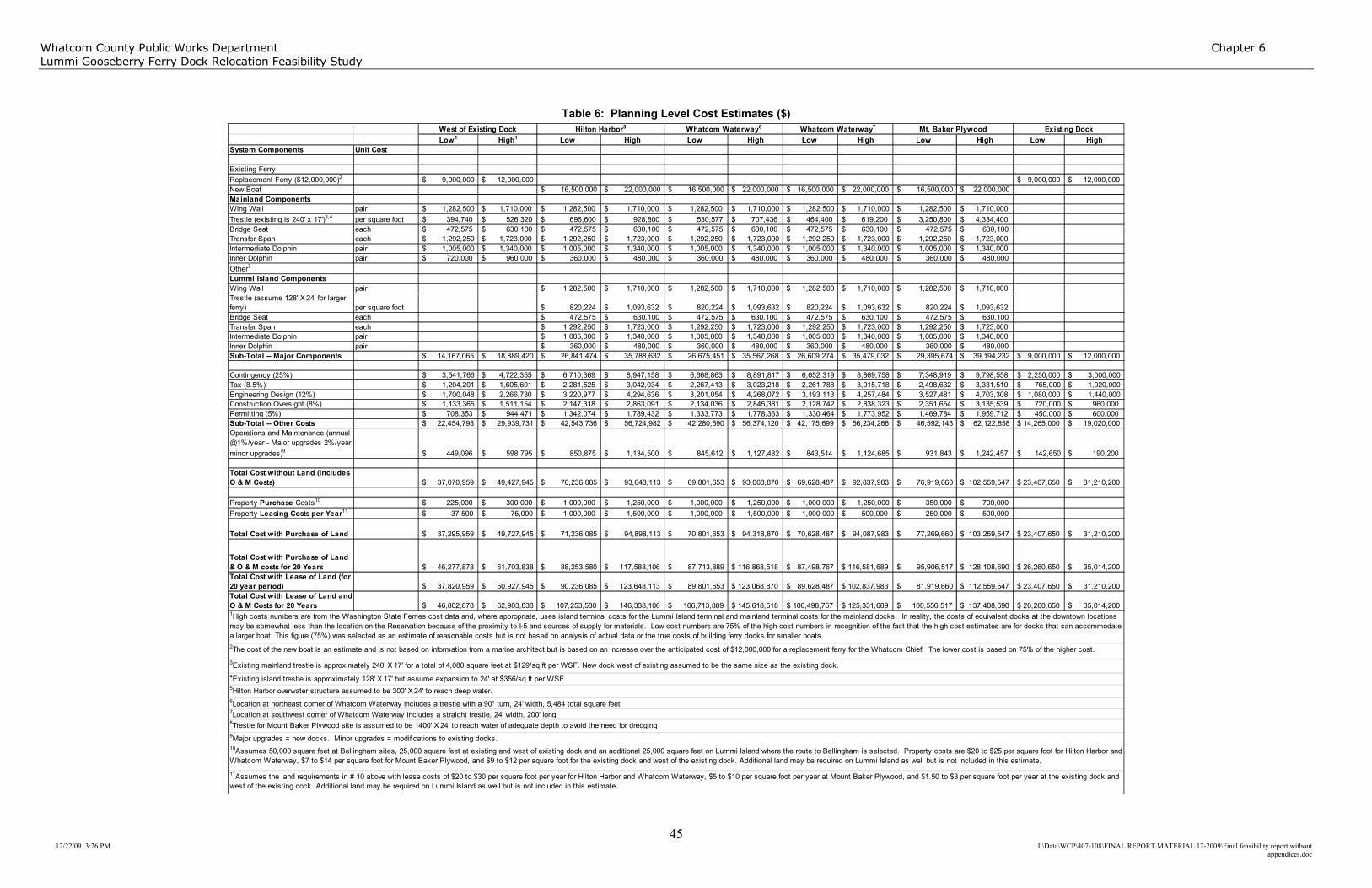
Whatcom County Public Works Department Chapter 6
Lummi Gooseberry Ferry Dock Relocation Feasibility Study
45 12/22/09 3:26 PM J:\Data\WCP\407-108\FINAL REPORT MATERIAL 12-2009\Final feasibility report without
appendices.doc
Table 6: Planning Level Cost Estimates ($)
Low1 High1 Low High Low High Low High Low High Low High
System Components Unit Cost
Existing Ferry
Replacement Ferry ($12,000,000)2 $ 9,000,000 $ 12,000,000 $ 9,000,000 $ 12,000,000
New Boat $ 16,500,000 $ 22,000,000 $ 16,500,000 $ 22,000,000 $ 16,500,000 $ 22,000,000 $ 16,500,000 $ 22,000,000
Mainland Components
Wing Wall pair $ 1,282,500 $ 1,710,000 $ 1,282,500 $ 1,710,000 $ 1,282,500 $ 1,710,000 $ 1,282,500 $ 1,710,000 $ 1,282,500 $ 1,710,000
Trestle (existing is 240' x 17')3,4 per square foot $ 394,740 $ 526,320 $ 696,600 $ 928,800 $ 530,577 $ 707,436 $ 464,400 $ 619,200 $ 3,250,800 $ 4,334,400
Bridge Seat each $ 472,575 $ 630,100 $ 472,575 $ 630,100 $ 472,575 $ 630,100 $ 472,575 $ 630,100 $ 472,575 $ 630,100
Transfer Span each $ 1,292,250 $ 1,723,000 $ 1,292,250 $ 1,723,000 $ 1,292,250 $ 1,723,000 $ 1,292,250 $ 1,723,000 $ 1,292,250 $ 1,723,000
Intermediate Dolphin pair $ 1,005,000 $ 1,340,000 $ 1,005,000 $ 1,340,000 $ 1,005,000 $ 1,340,000 $ 1,005,000 $ 1,340,000 $ 1,005,000 $ 1,340,000
Inner Dolphin pair $ 720,000 $ 960,000 $ 360,000 $ 480,000 $ 360,000 $ 480,000 $ 360,000 $ 480,000 $ 360,000 $ 480,000
Other7
Lummi Island Components
Wing Wall pair $ 1,282,500 $ 1,710,000 $ 1,282,500 $ 1,710,000 $ 1,282,500 $ 1,710,000 $ 1,282,500 $ 1,710,000
Trestle (assume 128' X 24' for larger
ferry) per square foot $ 820,224 $ 1,093,632 $ 820,224 $ 1,093,632 $ 820,224 $ 1,093,632 $ 820,224 $ 1,093,632
Bridge Seat each $ 472,575 $ 630,100 $ 472,575 $ 630,100 $ 472,575 $ 630,100 $ 472,575 $ 630,100
Transfer Span each $ 1,292,250 $ 1,723,000 $ 1,292,250 $ 1,723,000 $ 1,292,250 $ 1,723,000 $ 1,292,250 $ 1,723,000
Intermediate Dolphin pair $ 1,005,000 $ 1,340,000 $ 1,005,000 $ 1,340,000 $ 1,005,000 $ 1,340,000 $ 1,005,000 $ 1,340,000
Inner Dolphin pair $ 360,000 $ 480,000 $ 360,000 $ 480,000 $ 360,000 $ 480,000 $ 360,000 $ 480,000
Sub-Total -- Major Components $ 14,167,065 $ 18,889,420 $ 26,841,474 $ 35,788,632 $ 26,675,451 $ 35,567,268 $ 26,609,274 $ 35,479,032 $ 29,395,674 $ 39,194,232 $ 9,000,000 $ 12,000,000
Contingency (25%) $ 3,541,766 $ 4,722,355 $ 6,710,369 $ 8,947,158 $ 6,668,863 $ 8,891,817 $ 6,652,319 $ 8,869,758 $ 7,348,919 $ 9,798,558 $ 2,250,000 $ 3,000,000
Tax (8.5%) $ 1,204,201 $ 1,605,601 $ 2,281,525 $ 3,042,034 $ 2,267,413 $ 3,023,218 $ 2,261,788 $ 3,015,718 $ 2,498,632 $ 3,331,510 $ 765,000 $ 1,020,000
Engineering Design (12%) $ 1,700,048 $ 2,266,730 $ 3,220,977 $ 4,294,636 $ 3,201,054 $ 4,268,072 $ 3,193,113 $ 4,257,484 $ 3,527,481 $ 4,703,308 $ 1,080,000 $ 1,440,000
Construction Oversight (8%) $ 1,133,365 $ 1,511,154 $ 2,147,318 $ 2,863,091 $ 2,134,036 $ 2,845,381 $ 2,128,742 $ 2,838,323 $ 2,351,654 $ 3,135,539 $ 720,000 $ 960,000
Permitting (5%) $ 708,353 $ 944,471 $ 1,342,074 $ 1,789,432 $ 1,333,773 $ 1,778,363 $ 1,330,464 $ 1,773,952 $ 1,469,784 $ 1,959,712 $ 450,000 $ 600,000
Sub-Total -- Other Costs $ 22,454,798 $ 29,939,731 $ 42,543,736 $ 56,724,982 $ 42,280,590 $ 56,374,120 $ 42,175,699 $ 56,234,266 $ 46,592,143 $ 62,122,858 $ 14,265,000 $ 19,020,000
Operations and Maintenance (annual
@1%/year - Major upgrades 2%/year
minor upgrades)9 $ 449,096 $ 598,795 $ 850,875 $ 1,134,500 $ 845,612 $ 1,127,482 $ 843,514 $ 1,124,685 $ 931,843 $ 1,242,457 $ 142,650 $ 190,200
Total Cost without Land (includes
O & M Costs) $ 37,070,959 $ 49,427,945 $ 70,236,085 $ 93,648,113 $ 69,801,653 $ 93,068,870 $ 69,628,487 $ 92,837,983 $ 76,919,660 $ 102,559,547 $ 23,407,650 $ 31,210,200
Property Purchase Costs10 $ 225,000 $ 300,000 $ 1,000,000 $ 1,250,000 $ 1,000,000 $ 1,250,000 $ 1,000,000 $ 1,250,000 $ 350,000 $ 700,000
Property Leasing Costs per Year11 $ 37,500 $ 75,000 $ 1,000,000 $ 1,500,000 $ 1,000,000 $ 1,500,000 $ 1,000,000 $ 500,000 $ 250,000 $ 500,000
Total Cost with Purchase of Land $ 37,295,959 $ 49,727,945 $ 71,236,085 $ 94,898,113 $ 70,801,653 $ 94,318,870 $ 70,628,487 $ 94,087,983 $ 77,269,660 $ 103,259,547 $ 23,407,650 $ 31,210,200
Total Cost with Purchase of Land
& O & M costs for 20 Years $ 46,277,878 $ 61,703,838 $ 88,253,580 $ 117,588,106 $ 87,713,889 $ 116,868,518 $ 87,498,767 $ 116,581,689 $ 95,906,517 $ 128,108,690 $ 26,260,650 $ 35,014,200
Total Cost with Lease of Land (for
20 year period) $ 37,820,959 $ 50,927,945 $ 90,236,085 $ 123,648,113 $ 89,801,653 $ 123,068,870 $ 89,628,487 $ 102,837,983 $ 81,919,660 $ 112,559,547 $ 23,407,650 $ 31,210,200
Total Cost with Lease of Land and
O & M Costs for 20 Years $ 46,802,878 $ 62,903,838 $ 107,253,580 $ 146,338,106 $ 106,713,889 $ 145,618,518 $ 106,498,767 $ 125,331,689 $ 100,556,517 $ 137,408,690 $ 26,260,650 $ 35,014,200
9Major upgrades = new docks. Minor upgrades = modifications to existing docks.10Assumes 50,000 square feet at Bellingham sites, 25,000 square feet at existing and west of existing dock and an additional 25,000 square feet on Lummi Island where the route to Bellingham is selected. Property costs are $20 to $25 per square foot for Hilton Harbor and
Whatcom Waterway, $7 to $14 per square foot for Mount Baker Plywood, and $9 to $12 per square foot for the existing dock and west of the existing dock. Additional land may be required on Lummi Island as well but is not included in this estimate.
11Assumes the land requirements in # 10 above with lease costs of $20 to $30 per square foot per year for Hilton Harbor and Whatcom Waterway, $5 to $10 per square foot per year at Mount Baker Plywood, and $1.50 to $3 per square foot per year at the existing dock and
west of the existing dock. Additional land may be required on Lummi Island as well but is not included in this estimate.
Whatcom Waterway6Hilton Harbor5West of Existing Dock Mt. Baker Plywood Existing DockWhatcom Waterway7
8Trestle for Mount Baker Plywood site is assumed to be 1400' X 24' to reach water of adequate depth to avoid the need for dredging
5Hilton Harbor overwater structure assumed to be 300' X 24' to reach deep water.
1High costs numbers are from the Washington State Ferries cost data and, where appropriate, uses island terminal costs for the Lummi Island terminal and mainland terminal costs for the mainland docks. In reality, the costs of equivalent docks at the downtown locations
may be somewhat less than the location on the Reservation because of the proximity to I-5 and sources of supply for materials. Low cost numbers are 75% of the high cost numbers in recognition of the fact that the high cost estimates are for docks that can accommodate
a larger boat. This figure (75%) was selected as an estimate of reasonable costs but is not based on analysis of actual data or the true costs of building ferry docks for smaller boats.
2The cost of the new boat is an estimate and is not based on information from a marine architect but is based on an increase over the anticipated cost of $12,000,000 for a replacement ferry for the Whatcom Chief. The lower cost is based on 75% of the higher cost.
3Existing mainland trestle is approximately 240' X 17' for a total of 4,080 square feet at $129/sq ft per WSF. New dock west of existing assumed to be the same size as the existing dock.
4Existing island trestle is approximately 128' X 17' but assume expansion to 24' at $356/sq ft per WSF
6Location at northeast corner of Whatcom Waterway includes a trestle with a 90° turn, 24' width, 5,484 total square feet7Location at southwest corner of Whatcom Waterway includes a straight trestle, 24' width, 200' long,

Whatcom County Public Works Department Chapter 7
Gooseberry Point Ferry Dock Relocation Feasibility Study
46
12/22/09 3:26 PM J:\Data\WCP\407-108\FINAL REPORT MATERIAL 12-2009\Final
feasibility report without appendices.doc
Chapter 7: Task 103 − Identification and Discussion of
Fatal Flaws
The preceding chapters detail the results of the analysis of the alternative sites in terms of environmental, geotechnical, cultural, navigational and engineering considerations. Based on those analyses, none of the identified alternative sites appear to have fatal flaws (i.e., it appears that there are no obstacles that would ensure that a new dock could not be built at any of these locations). For example, some have environmental issues that would need to be addressed in the permitting process and may require some form of mitigation, but none of the sites appear to have impacts for which mitigation is not possible.
As shown in Table 6, there are significant costs associated with the design and construction of a new ferry terminal, and these costs will need to be fully considered before a decision is made to proceed with construction. Similarly, some of the sites pose greater obstacles than others in terms of environmental or cultural issues. An example of the latter is the site west of the existing Gooseberry Point Ferry Dock. There is a known cultural resource site located in vicinity. While the presence of this cultural resource does not appear to preclude development of a new dock at this location, it greatly complicates the process and may certainly result in opposition to this site from the Lummi Nation. In addition, the Lummi Nation may not be willing to sell or lease the land necessary for development in this location nor to permit the necessary activities.
While none of the sites have fatal flaws that absolutely preclude development, the practicality of developing the various sites should be considered as part of the ultimate decision process.
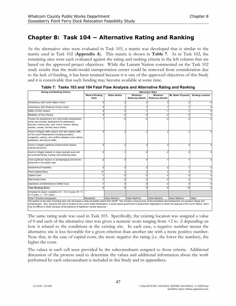
Whatcom County Public Works Department Chapter 8
Gooseberry Point Ferry Dock Relocation Feasibility Study
47
12/22/09 3:26 PM J:\Data\WCP\407-108\FINAL REPORT MATERIAL 12-2009\Final
feasibility report without appendices.doc
Chapter 8: Task 104 − Alternative Rating and Ranking
As the alternative sites were evaluated in Task 103, a matrix was developed that is similar to the matrix used in Task 102 (Appendix A). This matrix is shown in Table 7. As in Task 102, the remaining sites were each evaluated against the rating and ranking criteria in the left column that are based on the approved project objectives. While the Lummi Nation commented on the Task 102 study results that the multi-modal transportation center could be removed from consideration due to the lack of funding, it has been retained because it is one of the approved objectives of this Study and it is conceivable that such funding may become available at some time.
Table 7: Tasks 103 and 104 Fatal Flaw Analysis and Alternative Rating and Ranking
West of Existing
Dock
Hilton Harbor Whatcom
Waterway (North)
Whatcom
Waterway (South)
Mt. Baker Plywood Existing Location
Consistency with Lummi Nation Vision 0 2 2 2 2 0
Consistency with Whatcom County Vision 0 -1 -1 -1 -1 0
Safety of Ferry Service 0 0 -1 -1 -1 0
Reliability of Ferry Service 0 -2 -2 -2 -2 0
Fosters the development of a multi-modal transportation
center and ancillary development for pedestrians,
bicycles, motorcycles, cars, trucks, busses, fishing
vessels, canoes, the ferry and a marina.
1 -2 -2 -2 -2 0
Avoid or mitigate traffic impacts from ferry-related traffic
on the Lummi Reservations including accidents,
congestion, parking, and conflicts between motor vehicle,
pedestrian, and bicycle traffic.
0 2 2 2 2 0
Avoid or mitigate significant environmental impacts
(natural resources).
0 2 2 2 0 0
Avoid or mitigate impacts to treaty reserved usual and
accustomed fishing, hunting, and harvesting areas.
0 -1 -2 -2 -2 0
Avoid significant impacts on archaeological and historic
resources in the project area.
-2 0 0 -1 -1 0
Geotechnical Feasibility 0 -2 -2 -2 -1 0
Permit-related Risks -2* 2 2 2 2 0
Capital Costs -1 -2 -2 -2 -2 0
Real Estate Costs -1 -2 -2 -2 -2 0
Operations and Maintenance (O&M) Costs -1 -2 -2 -2 -2 0
Total Ranking Score -6 -6 -8 -9 -10 0
Schedule for project completion (S = 0 to 5 years, M = 6
to 10 years, L = 10+ years)
Other? Shoreline Designation Residential Urban Maritime Urban Maritime Urban Maritime Urban Maritime Urban
Alternative SitesRating and Ranking Criteria
*Excavation at the west of existing dock site will require a state excavation permit from DAHP. This includes a long process of documentation and development of a research design and
sampling plan. Also, because this site is located on the Lummi Indian Reservation, it would require government to government negotiations to obtain the approval of the Lummi Nation, which
may be difficult to obtain because of the presence of significant cultural resources.
The same rating scale was used in Task 103. Specifically, the existing location was assigned a value of 0 and each of the alternative sites was given a numeric score ranging from +2 to -2 depending on how it related to the conditions at the existing site. In each case, a negative number means the alternative site is less favorable for a given criterion than another site with a more positive number. Note that, in the case of capital costs, the more negative the rating (i.e. the lower the number), the higher the costs.
The values in each cell were provided by the subconsultants assigned to those criteria. Additional discussion of the process used to determine the values and additional information about the work performed by each subconsultant is included in this Study and its appendices.

Whatcom County Public Works Department Chapter 8
Lummi Gooseberry Ferry Dock Relocation Feasibility Study
48 12/22/09 3:26 PM
Based on the ranking developed for Tasks 103 and 104, the alternative sites are ranked as follows from most desirable to least desirable.
1. Existing Location
2. West of Existing Dock
3. Hilton Harbor
4. Whatcom Waterway North
5. Whatcom Waterway South
6. Mt. Baker Plywood
However, it should be noted that the range of scores from +2 to -2 is limiting and, in the case of the site west of the existing ferry dock, may be somewhat misleading. That location is located close to a known significant cultural resource site. Excavation at that site would require a State excavation permit from the Department of Archaeology and Historic Preservation (DAHP). This includes a long process of documentation, and development of a research design and sampling plan. Also, because this site is located on the Lummi Indian Reservation, it would require government to government negotiations to obtain the approval of the Lummi Nation, which may be difficult because of the presence of significant cultural resources. The result is that development of this site would, at best, be difficult, time consuming and expensive.

Whatcom County Public Works Department Chapter 9
Gooseberry Point Ferry Dock Relocation Feasibility Study
49
12/22/09 3:26 PM J:\Data\WCP\407-108\FINAL REPORT MATERIAL 12-2009\Final
feasibility report without appendices.doc
Chapter 9: Task 105 − Integration with Existing Plans
Lummi Nation Traffic Safety Study
Chapter 3 of the Traffic Safety Study addressed accidents on the Lummi Reservation. It is included, with changes based on this project, as Appendix E. The data shows that, the ferry traffic accounts for a significant amount of traffic and congestion on the roads and in the ferry waiting area. In reviewing the crash data, it is clear that several of the accidents occurred late at night or in the early morning after the boat had stopped its operations for the day. Therefore, it is difficult to determine which safety improvements would be most effective without a more detailed study. A reservation wide safety audit on all major through fares could provide clear guidance on this issue.
Whatcom County’s recommendations in Chapter 3 are as follows:
• Evaluate the installation of a protected left turn phase at the Haxton Way/Slater Road signal.
• Partner with Lummi Nation to enhance the pedestrian education program, with emphasis on wearing light colored clothing or reflective arm or leg bands to increase nighttime visibility.
• Partner with Lummi Nation to develop agreements and funding programs that will provide pedestrian facilities where appropriate.
• Consider moving the Haxton Way speed change from 50 to 35 mph to a location north of the Smokehouse Road intersection to reduce speed at the intersection.
• Continue and enhance the law enforcement “impaired driver” zero tolerance program. This could include roaming field sobriety stations using officer teams from Whatcom County Sheriff and Lummi Police.
• Develop a comprehensive joint agency program to reduce speed on the roads. In addition to the recommendations above, the Lummi Nation, as part of their comments on the Gooseberry Point Ferry Dock Relocation Feasibility Study, has suggested that the following recommendations also be added to the Traffic Safety Study.
• Perform a FHWA compliant Safety Audit of Haxton Way with special emphasis throughout the Gooseberry Point area.
• Provide sidewalks in and around the Ferry Terminal to facilitate pedestrian and Transit access.
• Convert the Kwina Rd. Haxton Way intersection and the Smokehouse Rd. Haxton Way intersection to roundabouts to reduce speed on Haxton Way and improve pedestrian safety.
• Study the use of off-site queuing of ferry traffic. As Whatcom County develops its future transportation and capital improvement plans, the County will involve representatives of the Lummi Nation in evaluating these recommendations and developing the County’s prioritized project lists.

Whatcom County Public Works Department Chapter 9
Gooseberry Point Ferry Dock Relocation Feasibility Study
50 12/22/09 3:26 PM
Therefore, the focus would appear to be most appropriately placed on efforts to reduce traffic speed on the Reservation, especially on Haxton Way, as it is a major north-south route from Slater Road to the ferry. Additional benefits may be gained by efforts to reduce traffic congestion during peak periods and identifying steps to minimize the congestion and disruption caused by traffic waiting in the vicinity of the terminal.
Lummi Nation Transportation Plan
It is recommended that Section 4.7 of the Lummi Nation Transportation Plan be amended as follows. New language is shown in italics.
4.7 Ferry Service
Whatcom County operates the Lummi Island ferry service at Gooseberry Point. The ferry connects to Lummi Island, south of the peninsula. The majority of ferry users travel to and from origins and destinations outside the Lummi reservation. They use Haxton Way and Kwina Road-Marine Drive as the primary access routes to and from the terminal. The ferry vessel carries 16 cars and 100 passengers year-round. It operates from 6 AM to 12 midnight at 20-minute intervals, with seven 40-to-60 minute breaks throughout the day. The vessel capacity is 48 vehicles per hour - three trips per hour, each carrying 16 vehicles. Ferry use peaks in the summer months at a level 40 percent higher than winter use. Ferry use drops precipitously in September.
The Lummi Island ferry service creates several problems on the reservation. During the peak summer months, there are frequent periods during which more traffic arrives at the Gooseberry Point terminal than can be accommodated by the ferry. On Haxton Way, pavement widens to three lanes from Ruth Road to the ferry dock. The extra lane is used to store ferry traffic. However, the queue lane is inadequate and results in long traffic queues along Haxton Way. The traffic queues last for hours and extend throughout the Gooseberry Point area. They impede driveway and side street access and circulation and are perceived by local residents as a safety hazard.
Ferry-bound traffic, especially motorists “trying to make the ferry” travels at excessive speeds along Haxton Way. Speeds of 60 MPH were recorded on the roadway segment just north of the ferry terminal. Although the ferry vessel carries only 16 vehicles, abrupt platoons of disembarking vehicles disrupt local access and circulation.
As part of the Traffic Safety Study, impacts of the existing and projected Ferry service were analyzed. This included the following tasks.
o Conduct an origin-destination interview of weekday vehicles using the ferry in both directions for the entire operating day.
o Conduct a limited origin-destination interview of weekend vehicles using the ferry in both directions between 8:00 AM and 6:00 PM.
There are a number of policies and activities which, if undertaken by Lummi in the future, will result in significant increases in safety for automobile drivers, passengers, and pedestrians on the Reservation. It is recommended that implementation of these measures be made a high priority by LIBC.

Whatcom County Public Works Department Chapter 9
Gooseberry Point Ferry Dock Relocation Feasibility Study
51 12/22/09 3:26 PM
Whatcom County provided $300,000 in 2006 for a feasibility study of the potential relocation of the Gooseberry Point Ferry Dock. This study was completed in December, 2009 by RH2 Engineering, Inc. Over the course of the study, fourteen potential ferry sites were evaluated and
the list of potential sites was reduced to 5, including the option of retaining the existing ferry
dock. The five sites were: the existing dock, a location west of the existing dock, Mt. Baker
Plywood, Hilton Harbor, and Whatcom Waterway (with two potential sites at Whatcom
Waterway).
Each of these remaining sites were evaluated for fatal flaws and it was determined that a new
dock at each of these facilities is feasible in that it appears the necessary permits could be
obtained and impacts could be satisfactorily mitigated although some of the sites pose greater
hurdles than others. The study found that each of the locations in Bellingham Bay are
significantly more expensive because of the requirement for a larger boat in order to ensure
safety and to maintain an acceptable level of service and this larger boat, in turn, requires
construction of a new dock in downtown Bellingham AND a new dock at the Lummi Island
terminal. Whatcom County and the Lummi Nation were provided copies of the final feasibility
study document.

52 12/22/09 3:26 PM
References
Angie J. Venturato, Vasily V. Titov, Harold Mofjeld, and Frank I. Gonz´alez. (2004). NOAA TIME Eastern Strait of Juan de Fuca, Washington, Mapping Project: Procedures, Data Sources, and Products. Retreived September 19, 2009 from the National Oceanic and Atmospheric Administration, Pacific Marine Environmental Laboritory Website: http://www.pmel.noaa.gov/pubs/PDF/vent2713/vent2713.pdf
Art Anderson and Associates. (2006) Geotechnical Report, Lummi Island and Gooseberry Point Ferry Terminals. HWA Project 2006-004-21.
Brown, J. (1994). Treaty Rights: Twenty Years after the Boldt Decision. Wicazo Sa Review 10(2):1-16.
Carlson, R. L. (1990). Cultural Antecedents.
In Suttles, W (Ed.) Northwest Coast 7: 60-69. Smithsonian Institution, Washington D. C.
HWA Geosciences. (2006). Geotechnical Report – Lummi Island & Gooseberry Point Terminals, Whatcom County, Washington.
National Oceanic and Atmospheric Association. (2006). Bellingham Bay Chart No. 18424.
National Oceanic and Atmospheric Association. (2009). Raster Navigational Charts. Retrieved August 12, 2009, from http://www.nauticalcharts.noaa.gov/mcd/Raster/index.htm.
Port of Bellingham. (2008). New Whatcom Redevelopment Project Draft Environmental Impact Statement. Conducted under the State Environmental Policy Act (SEPA).
Preston, Gates; and Ellis Law Firm. (2004). The Indian Law Handbook for Local Governments. Seattle, WA.
Priority Habitat and Species Maps. (2008). [Map]. Processed and delivered by Washington Department of Fish and Wildlife on August 19, 2008.
Satake, Kl, Shimazaki K., Tsuji Y., & Uede K. (1996). Nature, 379. 246-249.
Thorson, R. M. (1989) Glacio-Isostatic Response of the Puget Sound Area, Washington.
Geological Society of America Bulletin 101: 1163-1174.
U.S. Department of Commerce. (1992). Tidal Bench Mark. Retrived September 19, 2009, from the National Oceanic and Atmospheric Administration, National Ocean Service Website: http://tidesandcurrents.noaa.gov/benchmarks/benchmarks_old/9449184.html
U.S. Department of Commerce. (2009). Storm Events. Retrived September 19, 2009, from the National Oceanic and Atmospheric Administration, Satellite and Information Service Website: http://www4.ncdc.noaa.gov/cgi-win/wwcgi.dll?wwevent~storms
U.S. Fish and Wildlife Service. (2009). National Wetland Inventory Retrieved July 13, 2009, from the Website: http://www.fws.gov/wetlands/Data/index.html
Washington State Department of Ecology, (2009), Retrieved from the Toxic Cleanup Program Website: http:/www.ecy.wa.gov/programs/tcp/sites/blhm_bay_sites.html.

53 12/22/09 3:26 PM
Appendices