Embed Size (px)
Citation preview
GOODWIN MINERAL EXPLORATIONSJohn R. Goodwin, MSc Consulting Geologist
WARDEN 010
REPORT ON THE
MAGNETOMETER SURVEY
IN
WARDEN AND MILLIGAN TOWNSHIPS
FOR
POINT COMFORT RESOURCES
i., A r;; n i, \ ( i /,
NTS 42 A/9E Dec em he r 15, 1957
JOHN R. GOODWIN
Box 806 - Callander, Ontario POH 1 HO - 705-752-3850
mGOODWIN MINERAL EXPLORATIONS
John R. Goodwin, MSc Consulting Geologist
SUMMARY AND RECOMMENDATIONS.
Since the discovery of auriferous quartz boulder float to the south of Eastford Lake near the Warden/Mi.lligan township line in 1965, great interest has been developed in tracing the boulders to source. Consequent exploration programs by Kennco Explorations (Canada), Ltd. in 1965, Bay Resources and Services
since 1985, and recent and presently active exploration-programs by Noranda, Dome and Kerr Addison have indicated excellent potential for placer gold deposits within and on the flanks of the Munro esker complex.
The magnetometer/gradioraeter surveys conducted over the subject claims has detailed a number of anomalous areas, that warrant detailed soil sampling of the "C" horizon. Anomalous soil assays will be further tested by reverse circulation drilling to test the presence of stacked auriferous horizons in /on the flanks of the. esker and the gold potential in buried valleys under the esker. The gold bearing horizons will be developed using a gravity centrifugal process to recover fine gold common to placer deposits in the esker
Box 806 - Callander, Ontario POH 1 HO - 705-752-3850
GOODWIN MINERAL EXPLORATIONSJohn R. Goodwin, MSc Consulting Geologist
INTRODUCTION
Goodwin Mineral Explorations was commissioned fry Point Comfort
Resources to carry out a detailed magnetometer/gradiom^ter
survey covering 12 contiguous claims covering a portion of the
Munro esker in Warden and Milligan townships. This report is
based on field surveys and a study of available literature,
assessment and government reports, recent developments on adjoining ,
properties and recommends an initial soil sampling program to
confirm auriferous magnetite lenses which appear to have th.e
greatest potential for economic gold production.
PROPERTY LOCATION AND ACCESS
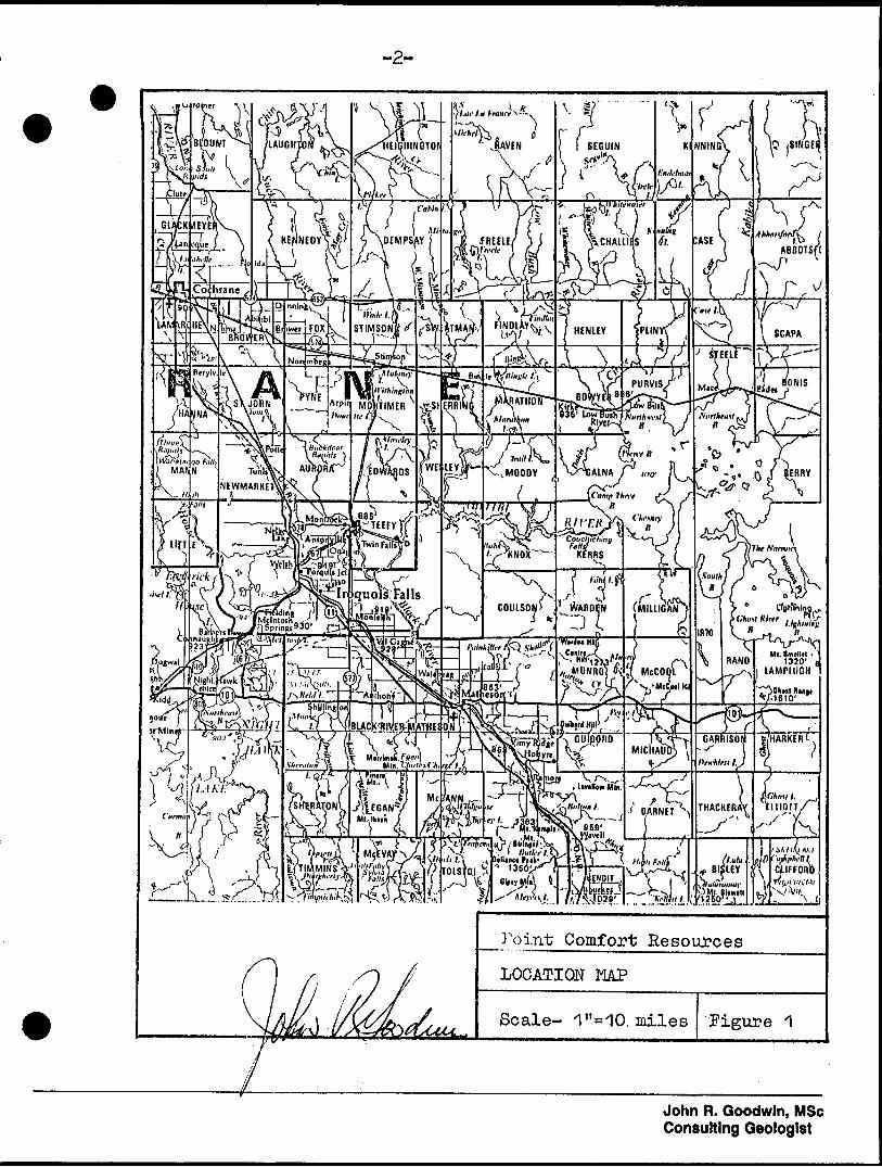
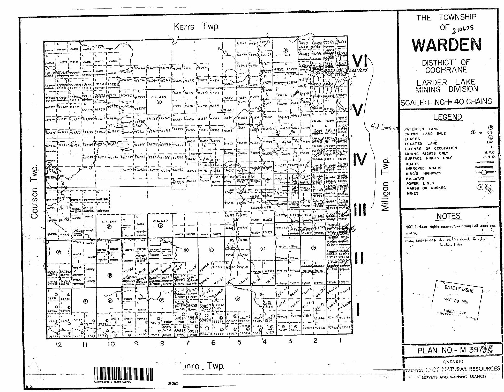
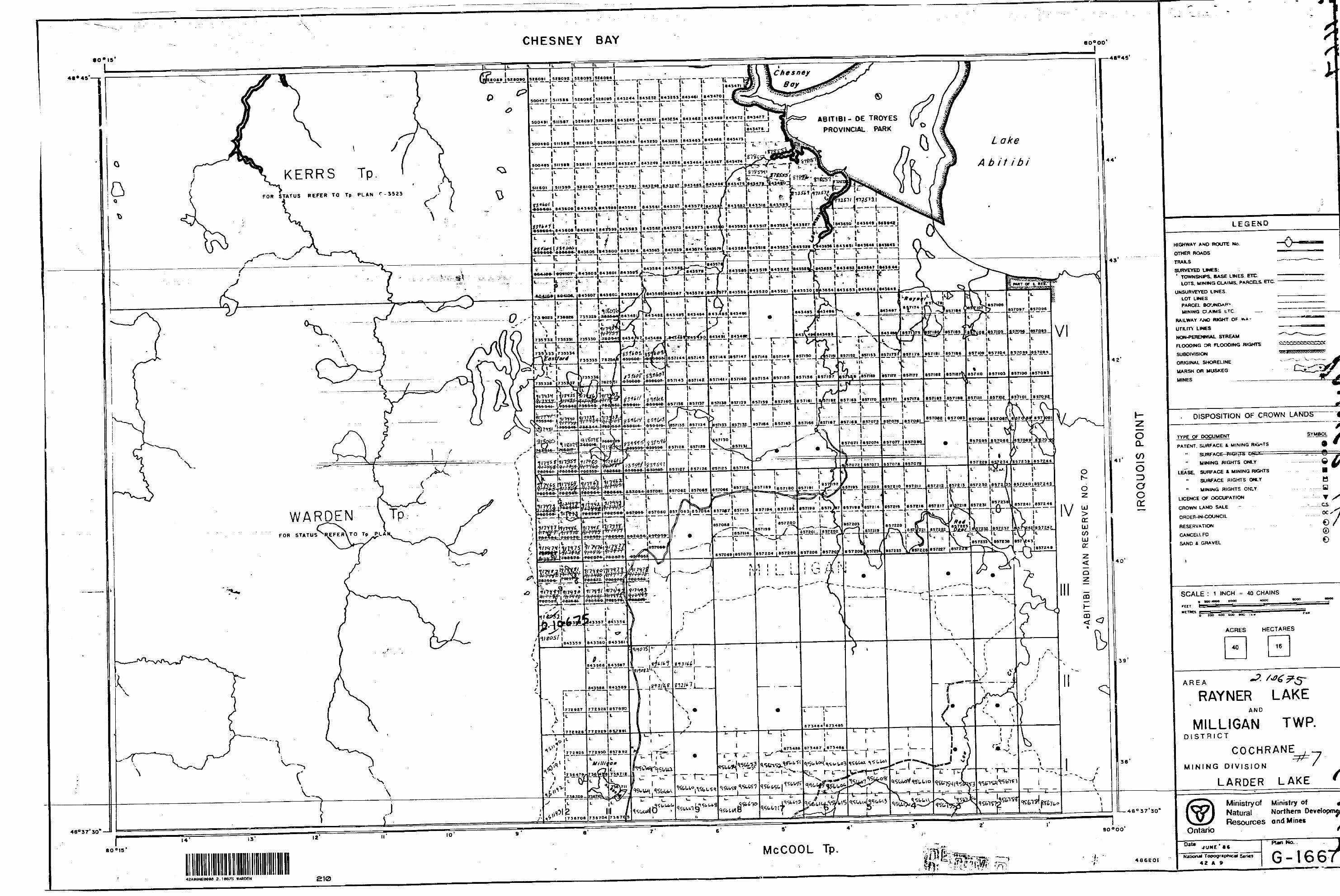
The subject property consists of 12 contiguous claims situated in
the southeast portion of Warden Township and adjoining Milligan
township (Figurel) . The claims are easily acce.ssab.le via Highway 10.1
for 16 miles east of Matheson, then approximately 6 miles north,
along the esker on good gravel logging and forest access roads
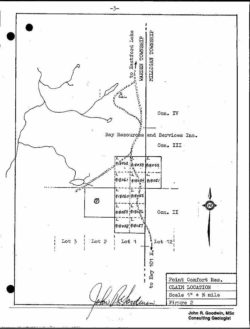
CLAIM LOCATION AND STATUS
The 12 contiguous claim block covers part of Lot il, Concession 2
andc3 inoWarden Township and includes 2 claims in Lot 12, Concession
3 in Milligan Township (Figure 2)..
Box 806 ' Callander, Ontario POH 1 HO * 705-752-3850
-2-
AM^L.
Point Comfort Resources
LOCATION MAP
Scale- ). miles Figure 1
John R. Goodwin, MSc Consulting Geologist
-5-
Con. IV
and Services Inc.
Con. Ill
Lot 5 ! Lot 2 j Lot 1
Point Comfort Res.CLAIM LOCATIONScale 1" * J6 mile
John R. Goodwin, MSc Consulting Geologist
r PHYSIOGRAPHYThe Munro esker trends southerly across the central portion of the claims and consists of a winding plateau, one "to four miles wide, rising about 100 feet above the surrounding flat clay belt. Jack pine predominate on the sandy ridge of the esker with spruce and alder on the adjacent swampy flats. Some poplar and birch occur locally.
HISTORYA limited amount of surface exploration has been carried out in the vicinity of the Munro esker because of the thick mantle of sand/gravel and thus very few outcrop exposures. Serious interest began in 1965 when quartz boulder float containing up to 6 oz/ton were found. 1965 - Kennco Explorations (Canada) Ltd. carried out soil geochemical and resistivity surveys in the vicinity of East- ford Lake. The surveys failed to find the source of the flo.at, however widespread free (placer) gold was found within the esker sands and gravels. Deep paleovalleys in the bedrock surface under the esker complex were also indicated, These valleys were confirmed by hammer seismic surveys.
- Kennco also carried out I.P., Turam and magnetometer surveys following bedrock conductors outlined by an AEM survey in the vicinity of the subject claims. Diamond drilling failed to locate economic mineralization. 1965 to present - some research projects conducted on different portions of the esker by O.GoS. and G.S.C. staff: Lee (1965); Lang (1970); Boyle (1979); Baker (1981). 1984-1986 - Bay Resources and Services Ltd., immediately north of the subject claims, conducted soil sampling and magnetometer surveys at 200 1 intervals. 125 ton bulk samples were also collected. Anomalous zones were tested by a gravity concentrator which returned very encouraging results.
John R. Goodwin, MSc Consulting Geologist
5
- Noranda, Dome and Kerr Addison are also carrying out extensive exploration programs to the north, of Eastford Lake in Kerrs and Chesney Townships. Noranda has reported assays up to .15 oz/ton gold over 5tto 10' of esker material. Their exploration programs are on-going.
BEDROCK GEOLOGY
The subject claims are "believed to be underlain by Pre cambrian mafic to intermediate metavolcanics with minor mafic to felsic intrusive rock units. An AEM survey indicates a northeasterly trending magnetic unit across the central portion pf the property. A string of AEM conductors trends southeasterly through the north- central and south portion of the claims. Part of this conductive trend was tested west of the property by Kennco in 1965 indicating graphite and uneconomic sulphides in mafic metavolcanics.
GLACIAL GEOLOGY
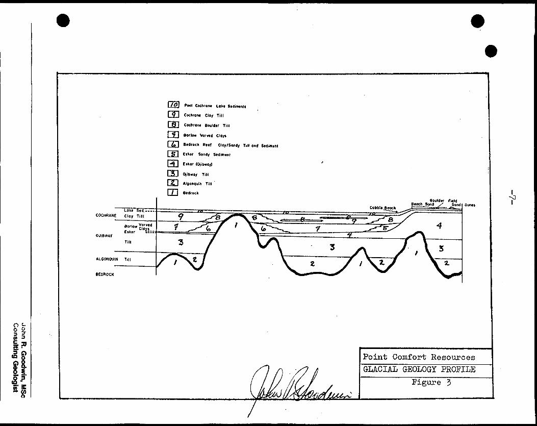
The Munro esker passes through the Kirkland Lake gold camp and is essentially continuous for about 250 miles and is up to four miles wide. The glacial events interpreted for the area are outlined below.
Glacial event DepositRECENT- - Aeolian depositsCOCHRANE r Glaciolacnstrine deposits
Glaciofluvial deposits Boulder till, sandy till
OJIBWAY - Glaciolacustrine deposits includingBARLOW varved clays
Glaciofluvial outwash deposits including MUNRO esker
ALGONQUIN - Till
John R. Goodwin, MSc Consulting Geologist
-6-
Bedrock cover in the region probably began with the Algonquin ice advance depositing a basal till unit in the adjacent valleys. The later Ojibway advance of Wisconsin age deposited a second till and farther modified the topography. During deglaciation, a south trending esker complex developed on the primary OJibway till. Ablation of the Ojibway sheet resulted in the formation of glacial Lake Barlow/Ojibway behind the retreating ice front. Deposition of the Barlow varved clays on top of the Ojibway tills developed. Bedrock exposures through this mantle by this time were few. Advance of the Cochrane ice sheet resulted in the de development of a clay till on top of varved clays and boulder tills on top of the esker complex. The stratigraphic sequences as outlined are illustrated in Figure 3. The Munro esker is characterized by a winding plateau marred by depressions and bell-shaped ridges. Interestingly, the zones of larger surface depressions corresponds to the subsurface zones of deepest depression in the bedrock surface(Hobson and Grant, 1964). The thickness of sediments below these depressions is considerable as one vertical drill hole did not reach bedrock at 290 feet. The esker sediments are predominately sand with a mixture of rock fragments and mineral grains .that have undergone moderate sorting in a braided stream environment. Thin layers of gravel, cobbles and boulders are also present where sheet bedding is characteristic. Cross-bedding occurs locally and is of the type suggesting deposition from a braided stream.Wave action by Lake Barlow/0Jibway has in some places washed a considerable thickness of sands and gravels onto the flanks of the esker and some boulder beaches remain. A particularly interesting possibility for placer goldis represented by these beaches up to 1900 feet wide along the edge of the esker and are essentially not yet explored.
John R. Goodwin, MSc Consulting Geologist
-7-
i
^o w
I fi
3Ry
i* l ^ gH
:i 1111u
u
5
*
SSBSB
HB
SB
CO Q)ra oo oloP*
HS So
KA(D&D
H
John R. G
oodwin, M
Sc
Consulting G
eologist
-8-
These deposits have been developed from reworked esker material and could be expected to contain gold values higher than those found so far on the crest of the esker. The aeolian sands are a product of winnowing and occasionally contain concentrations of fine magnetite in characteristic " black sand " lenses.
ECONOMIC GEOLOGYGold occurs widely throughout the esker as small flattened grains to 1mm in heavy mineral seperates associated with magnetite, garnet and zircon. To date most of the sampling has been collected from the upper 2 feet, immediately under lying the "B" soil horizon. Several bulk samples up to 125 tons were also collected on the Bay Resources property immediately to the north however the anomalous targets had not been identified and were from lower, grade material. Sporadic sampling has been carried out to evaluate thevertical^ gold distribution profile but none have been co-ordinated thus no trends or preferred stratigraphicglacial or periglacial unit has been identified.
The Bay Resources exploration program on their property immediately north of the subject claims has indicated that the larger gold flakes are apparently concentrated with co coarse magnetite in areas where there is a high proportion of pebbles and cobbles. The gold has probably been enriched by wind and wave action with entrapment of magnetite, garnet, zircon and gold between the pebbles. The locating and identifying of these magnetiteorich lenses is the prime objective of this initial exploration program.
DISCUSSIONThe subject claims have two potential gold bearing horizons that warrant investigation and evaluation in a thorough comprehensive exploration program.
John R. Goodwin, MSc Consulting Geologist
4. The initial target is to locate and confirm placer gold deposits associated with magnetite lenses (black sands ) within the esker and/or flanking beach deposits. 2. The deep paleovalleys in the bedrock surface will also have high potential for gold bearing gravels in and above the basal till as they were primary river channels. These valleys will be confirmed by seismic surveys and tested by deep overburden drilling to bedrock with detailed identif ication and sampling of the overlying gravels and till for gold distribution..This report recommends an exploration program for placer gold in the near surface portion of the esker complex and flanking beach deposits. This program includes line- cutting at 200' line spacing and detailed gradiometer/ magnetometer surveys at 50' stations with fill-in readings where warranted. The EDA Dmni-4 is computerized and has a sensitivity of .01 gammas. The survey is co-ordinated with a recording base station so that diurnal fluctuations are continually recorded and applied to the corrected read out. This survey will record the magnetic gradient with a one meter"head 'seperation and the total field of the under lying esker material and bedrock.Following this survey, the anomolous magnetic zones would be soil sampled using established procedures to determine grade and dimensions. Those areas yielding anomalous gold values could then be further processed or evaluated using a gravity concentrator to recover the fine grained gold content. A gravity concentrator was tested on the Bay Resources property and performed at 85?o recovery of the gold at a 500 ton/hour feed. This equipment appears to be best suited to recover the fine gold from the esker material tested to date.
John R. Goodwin, MSc Consulting Geologist
-10-
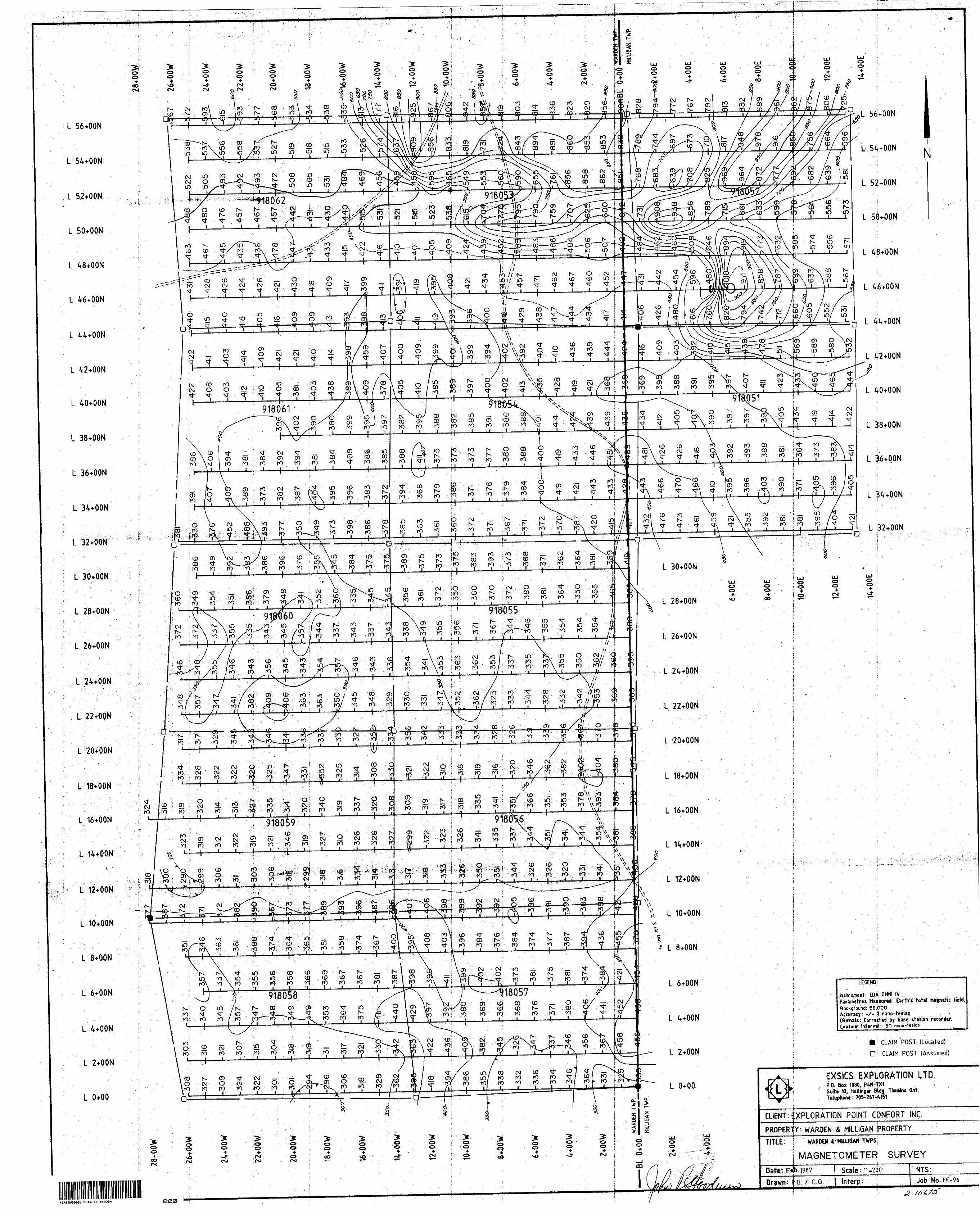
SURVEY RESULTS
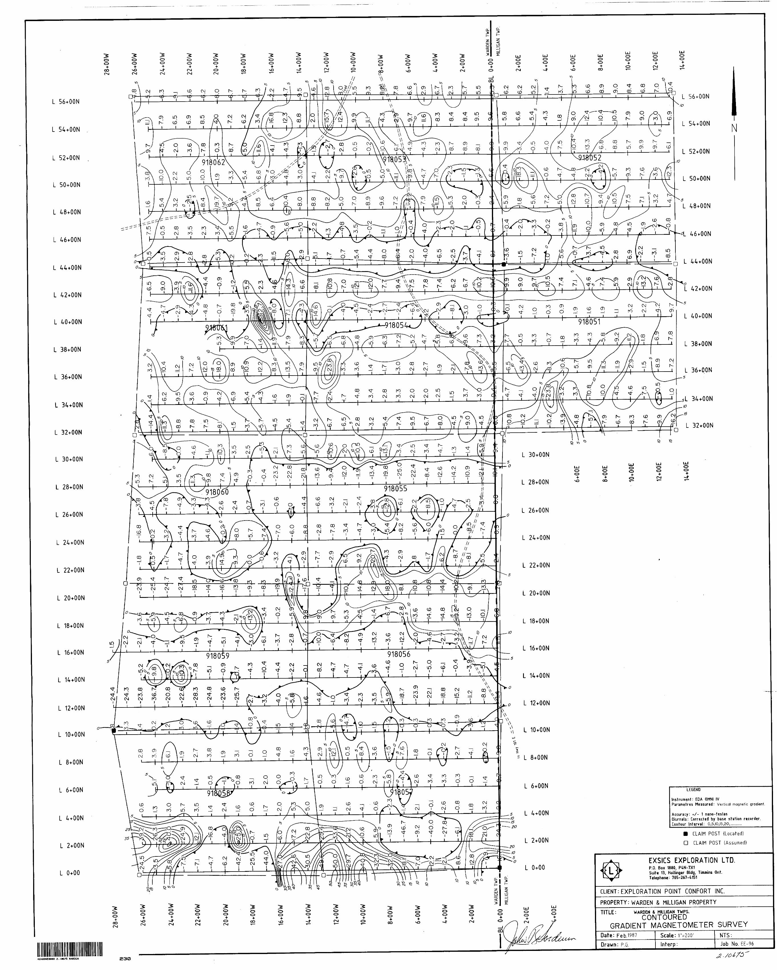
Two magnetic profiles were compiled from the survey data collected over the property. An EDA Omni IV magnetometer measured the total magnetic field and the vertical gradient with two sensors located l meter apart on a vertically held mast. The sensors are simultan eously energized and the difference in the total magnetic field between the upper and lower sensors divided by the sensor seperation ( l meter) yields a vertical magnetic gradient in gammas per meter. The total magnetic field reading obtained from the upper sensor is retained as the total magnetic field value.
Magnetic anomalies, both total field and vertical gradient, are caused by small variations in magnetic susceptability as the terrain is traversed. Where there is no magnetic susceptability contrast in specific areas of overburden or bedrock, no magnetic anomalies are created. Low total magnetic field values will yield moderate to high negative magnetic gradient values. These areas are not likely to contain disseminated or placer-type accumulations of magnetite. Those areas containing moderate to high total field magnetic response will also have high positive magnetic gradients. If the area traversed is uniformly high or low in magnetic susceptahi.li.ty, the vertical gradient will be closer to zero.
Total Magnetic Field
The total magnetic field response in this survey appears, much stronger in the northeast portion of the subject claims and is in response to the top and western flanks of the Munro esker. This area of high, magnetic susceptability decreases sharply along a line trending northwesterly from L42 + QON/14 + OOE to L56-*-aONA6*O.O.W. The remainder
John R. Goodwin, MSc Consulting Geologist
-11-
of the property decreases in magnetic susceptabdlity to the south and west to a discrete magnetic low at LQ+O.O./18-to 2Q+O.O.WL.
Vertical Magnetic Gradient
The vertical gradient plots do not show the same magnetic sus:cept- ability trends as the total field.Because the grid was set up to locate paleo-beach deposits with associated "black sand" beach strands running roughly parallel to the western flanks of the esker, the magnetic responses will respond in part to the underlying bedrock geology which is believed to strike roughly east-west. One of the sensor heads is much closer to the ground surface and is therefore much more sensative to small scale local variations in the overburden/bedrock composition. An erratic 6" boulder of iron formation buried 6ne to two feet under the surface will cause a sharp small positive vertical anomaly in a relatively flat response area. Small bull-eye anomalies will probably be due to this type of situation.
Favourable areas with potential for containing gold hearing horizons with associated magnetite would be represented b.y broad areas of positive vertical gradient. Some attractive areas are L48 + O.ON to L56+OON; L30+OON to 40+OON; L18 + OON to 22+O.O.N east of the baseline. There are several areas where total field and vertical gradient anomalies coincide: L36*OOn7l2*OOW; 54^5.6 + aON/l^aaW; 5(H-0.(W2*auE; 46 + OON/6 + OOE; L8 + OON/12+OO.W.
The area from 0+00 to 10+OON is difficult to evaluate because of short,strong negative and positive vertical gradients in an area of relatively flat total field response. This area may be underlain by
John R. Goodwin, MSc Consulting Geologist
-12-
a complex boulder field with accumulations of randomly distributedmagnetic boulders a short distance under the surface.A very strong positive vertical gradient anomaly is located onL40+OON/17+OOW and is probably due to a boulder with high magneticsusceptability.
DISCUSSION
A number of areas with favourable magnetic susceptability were
found on the property. At the present time it is not known the depth or signifigance of these anomalies other than there are magnetic
minerals present. Bay Resources holds the claims immediately to the north and have carried out detailed soil sampling of the "C" horizon. The samples consisted of l cubic foot of material collected at 12"
delow the surface, screened to -h", sluiced over rubber mats to produce a gravity heavy concentrate of heavy minerals. This concen trate consisted of magnetite, garnet and gold which was then panned and the visual gold content documented for each sample location. A later phase of exploration included the use of a centrifugal seperator which gave encouraging results in recovering the fine gold common to placer deposits in the esker. Equipment developed to date are the Knelson Hydrostatic Concentrator and the "Gold-spinner"
RECOMMENDATIONS
Those areas of broad positive magnetic gradient that occur seperately or coincide with total field anomalies should b.e tested by detailed soil sampling with heavy mineral seperates assayed for gold tenor
and particle size. This sampling program would only test a thin layer
John R. Goodwin, MSc Consulting Geologist
-13-
near the surface of the property. Anomalous areas should be further
tested and evaluated by reverse circulation drilling to establish
the presence of stacked auriferous horizons and evaluate the gold
potential of buried valleys under the esker. Anomalous areas will ;l
then be selectively mined using gravity centrifugal seperation
equipment handling up to 300 tons/hour of source material.
John R. Goodwin, MSc Consulting Geologist
-14-
REFERENCES
Graham, E. J. 1984: The potential for alluvial goldproduction. Bay Resources and Services Inc.
1984: Sampling program for gold at the Eastford Lake alluvial gold property in the Townships of Warden and Milligan.
1984: Gold particle counts at the Eastford Lake alluvial gold property in the Townships of Warden and Milligan
1985: Geological report with recommendationson the results of soil sampling for gold. Bay Resources and Services Inc.
1985: Assessment work report, soil samplingfor gold in Warden and Milligan Townships. Bay Resources and Services Inc.
Ho"bson, G.D. and Grant, A.C. 1964: Tracing buried river valleysin the Kirkland Lake area with a hammer seismograph. Canadian Mining Journal, April.
Lee, H. A. 1965: Glacial fans in till from the Kirkland LakeFault. A method of gold exploration. Geological Association of Canada, Paper 63-45
1965: 1. Investigation of eskers for mineral exploration2. Buried valleys near Kirkland Lake, Ontario.
Ontario Geological Survey: Kirkland Lake, OntarioAssessment file data for Warden and Milligan Townships.
Parent, D. 1985: Technical report on the Bay Resources andServices Inc. gold project . Warden and Milligan Townships.
John R. Goodwin, MSc Consulting Geologist
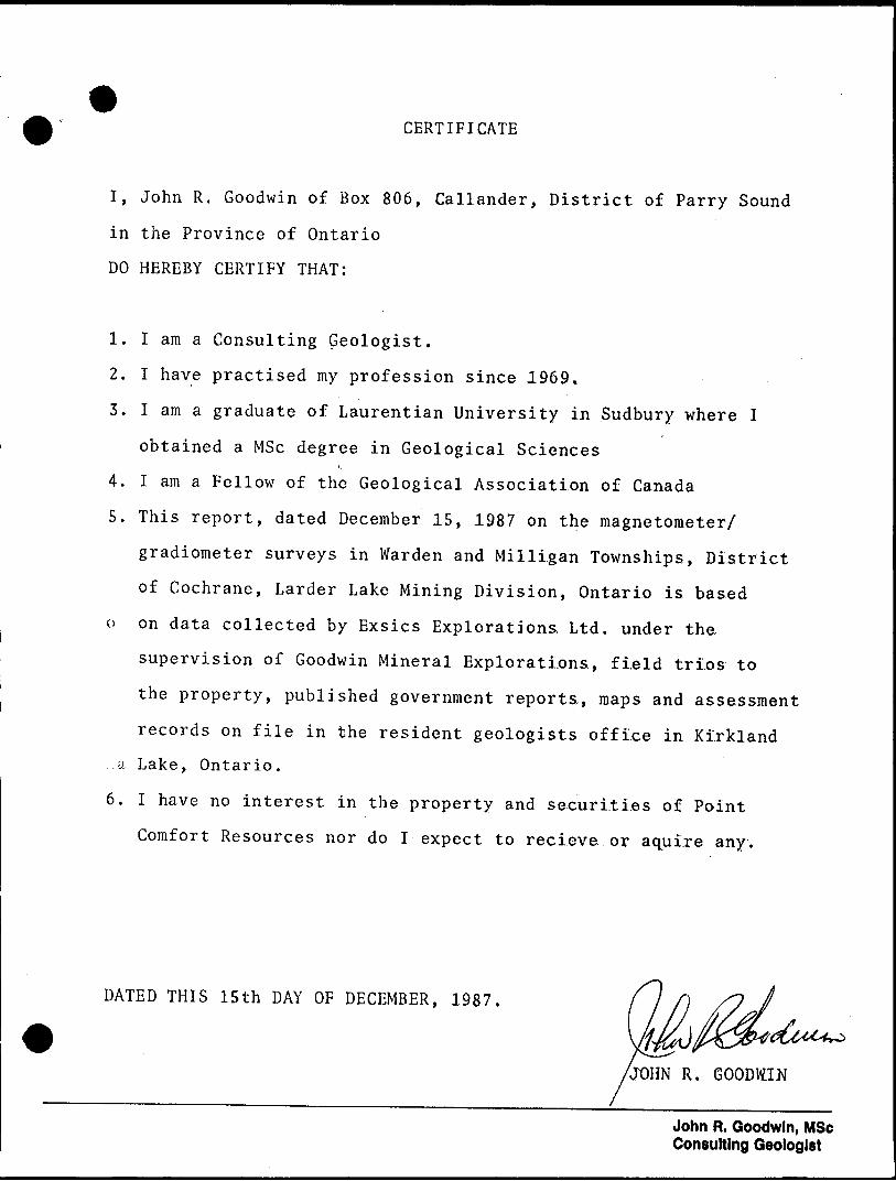
CERTIFICATE
I, John R. Goodwin of Box 806, Callander, District of Parry Sound
in the Province of Ontario
DO HEREBY CERTIFY THAT:
1. I am a Consulting Geologist.
2. I have practised my profession since 1969,
3. I am a graduate of Laurentian University in Sudbury where I
obtained a MSc degree in Geological Sciences
4. I am a Fellow of the Geological Association of Canada
5. This report, dated December 15, 1987 on the magnetometer/
gradiometer surveys in Warden and Milligan Townships, District
of Cochrane, Larder Lake Mining Division, Ontario is based
o on data collected by Exsics Explorations, Ltd. under the
supervision of Goodwin Mineral Explorations., field trios to
the property, published government reports,, maps and assessment
records on file in the resident geologists office in Kirkland
a Lake, Ontario.
6. I have no interest in the property and securi.ti.es of Point
Comfort Resources nor do I expect to recieve or aqui.re any.
DATED THIS 15th DAY OF DECEMBER, 1987.
JOHN R. GOODdfl
John R. Goodwin, MSc Consulting Geologist
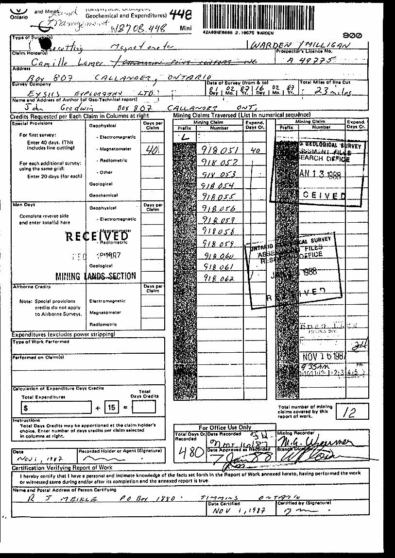
NsiL/ and Mines'-^. Ontario *- Geochemical and Expenditures)
™#"**^.W10S,WG M i"!type o*
42A09NEeeee 2.i e* 75
Claim HoioerltTu^
Address
' aaa: T f Ant f"4i
Prospector's Licence No.
Survey Company Date of Survey (from 4 to)f 0i #9 l /*4 . O?- tf? r" l Mo. l y?, l Day l Mo. j Yr.
Total Miles of line Cut
(5 f/* CO/I q y f "J.Name and Address of Author (of Oeo-Technlcal report) i
J oJ^ GcCCfMf^T. ft(*V #6?- 0v r;Credits Requested per Each Claim in Columns at rightSpecial Provisions
For first survey:
Enter 40 days. (This includes line cutting)
For each additional survey: using the same grid:
Enter 20 days (for each)
Man Days
Complete reverse side and enter total(s) here
RE(
t 'F. C
MINING 1Airborne Credit!
Note: Special provisions credits do not apply to Airborne Surveys.
Geophysical
- Electromagnetic
- Magnetometer
- Radiometric
- Other
Geological
Geochemical
Geophysical
- Electromagnetic
:tfwer- Radiometric
;p'WGeological
.ftKD&nSECTION
Electromagnetic
Magnetometer
radiometric
Days per Claim
W
Days per Claim
Days per Claim
Expenditures (excludes power stripping)Type Of Work Performed
Performed on Cliim(s)
Calculation of Expenditure Days Credit!
Total ExpendituresTotal
Dayt Credits
InstructionsTotal Days Credits may be apportioned at the claim holder's choice. Enter number of days credits per claim selected In columns at right.
Date
i , "*9-Recorded Holder or Agent (Signature)
Certification Verifying Report of Work
Mining Claims Traversed (List In numerical sequence)
Totel number of mining claims covered by this report of work.
For Office Use OnlyTotal Days Or. Recorded
wDate Recorded ff^. t \
fry. H2±JeteAi
Mining Recorder
l hereby certify that l haw a personal and intimate knowledge of the facts set forth In the Report of Work annexed hereto, having performed the work
or witnessed same during and/or after its completion and the annexed report is true.
Name and Postal Address of Person Certifying
/y ra ' TtOat* Certified
A/0 V iCertified by (Signature)
Kerrs Twp.U 7
l -Q- l*^
986579 ! 986578 , 336575 [ 9SW74
L
ITS l lzr^-L--. 9fe
986560 936577 986575 . 364573 3*6570 38656*
L | L ""
l•70?tjO 1-^54529-^ a04^ ; r i3 04S*- , -5O*6H- I fr6*^OL- 4
' —— —— ———V - ——— ——— ——— ——— '- ———— ——L ——— ———— ——f—————— ———
7 | L Ifc. l L l L H L \-
— L — i ±\^ (US^ 0^^
^W^T^j^ |^ l,1^ U28 * f,
\ ~Tt-— T1- \ ^^
JjVa-^ao- [-Taa*fro- i-^aast*
to^tf w t^/ L ^t i 11 4i~mfi\ \3tviAr;^~* A W ^I*OT|Wtt *TT"s? terttff - ~ ' ' ^r^C'S ^.i/Jn/i l i'-rajT--- **** -* ** ** ^ - *^ **i. -L li*"* i i tpsyt-V - i r tf*r jiw i ^r^-.^* . ^
^ * l a i^iiff*Lt \ l " L^ i u
*C^a4J-{-qoi'*- t
l . l j .
*r ~~ir ~ ~ir~~i
-COP ) ^jz^sy V _ _
753008 135009
jnro. Twp.
THE TOWNSHIP
DISTRICT OF COCHRANE
LARDER LAKE DIVISIONMINING
SCALE'l-INCte 40 CHAINS
LEGEND
PATENTED LAND
CROWN LAND SALE
LEASES
LOCATED LAND LICENSE OF OCCUPATION MINING RIGHTS ONLY SURFACE RIGHTS ONLYROADSIMPROVED ROADS KING'S HIGHWAYS RAILWAYS POWER L INES MARSH OR MUSKEGMINES
or C.S
@ Loc
LO-
M.9.O -S. r* C
NOTESSurfqct rihta reservation arounJ all loke*
l^i LSlC.'t'To-
E
^
i
PLAN NO.- M 397tJF
ONTARIO ;^Ti?v ~:? r̂ ATtJRA! R^SOUPC^Sl^r p . * r \./" S ^ JTt J X/IX^^ t. l\i.*JXX^* IV^*fc O
B. D.
42*e9NEMM 2.18675 WARDEN seta"SURVSYS A ND MAPFiNG BRANCH
* l*
m lw
—l—
——
L.v
.-•
T—
——
-1
rT
. ri
li ;
r
r i
iT~
"T
-"**
AB
ITIB
I IN
DIA
N
RE
SE
RV
E
NO
. 70
RO
QU
OIS
PO
INT
\\\
L 56+OQNL 56*OON
54+OONL'54*OON
L 52+OONL 52+OON
L 50+QON
L 50+OONm"-" FOqo-^—co——oo
L 48+OONro if)// in
L ^6+OON
n L 44+OON
L U+OON
L 42+OONL 42+OON
L 40+OONL 40+OON
918061 'L38+OON
L 38+OON
L 36+OON
L 36+OON
L 34+QON
L 32+OON
L 32+OO
L 30+OONL 30+OON
L 28+OONL 28+OON 918055
L 26+OONL 26+OON
L 24+OON
l 22+OONL:22*OO
L 20+OONL 20^00N
L. 18+OONL te*OON
L 16*OONL 16+OON
L tt+OONL 14*OON
L 12+OON
L 10+OONL 10+OON
L 8+OONL 8+OON
O K 00 ro ro
S L 6+OONL 6+OON ^—-118057 Instrument: EDA OMNI IV
: Earth's totit m*5ne!k Hcirf,Background: 58,000 Acaracy: *A ;1 nano-teslas OiurnaU: CorretUd by base station Contour InUfVaH: 50 nono-teslas
L 4+OON
(P fO *Oro—r*V ro CLAIM POST (Located)
CI. CLAIM POST (Assumed)L 2+OONL 2+OON
EXS1CS EXPLORATION LTDP.O. Box 1880. P4*HX1Suits 13, Hollinger Bidg, Timmins Ont.Telephone: 705-267^151
CLIENT XPLORATION POINT CDNFORT INCPROPERIY: W ARDEN 4 MILLIGAN pROPERTY
WARDEN VMILU6AN TWP.S
MAGNETOMETER SURVEY
Scale: 1 ^200'Draw: I.e. l c .G Job No.EE-96
42A09NEM08 2.10675 WARDEN
L 56+OON
L 54+OON
L 52+OON
L 50+OON
L 48+OON
L 46+OON
L U+OON
L 42+OON
L 40+OON
L 38+OON
L 36+OON
L 34+OON
L 32+OON
L 30+OON
L 28+OON
L 26+OON
L 24+OON
L 22+OON
L 20+OON
L 18+OON
L 16+OON
L 14+OON
L 12+OON
L 10+OON
L 8+OON
L 6+OON
L 4+OON
L 2+OON
L 0+00
o otCO
CD 00 CD
918062
cvj CD r i
918051
918055
[O O/ c
918059 918056
^ oo
L 56+OON
L 54+OON N
L 52+OON
L 50+OON
L 48+OON
46*OON
D L 44+OON
L 42+OON
L 40+OON
L 38+OON
L 36+OON
L 32+OON
LEGEND
Instrument: EDA OMNI IVParametres Measured: V ertical magnetic gradient.
Accuracy: */- 1 nano-feslasDiurnals: Corrected by base station recorder.Contour Interval: 0,5,10,15,20.............
B CLAIM POST (Located)
D CLAIM POST (Assumed)
EXSICS EXPLORATION LTDP.O. Box 1880. P4N-7X1Suite 13, Hollinger Bldg, Timmins Ont,Tetephonc: 705-267-^151
CLIENT: EXPLORATION POINT CONFORT INC.
PROPERTY: WARDEN 4 MILLIGAN PROPERTY
o•*-OO C^J
TITLE: WARDEN Ir MILLIGAN TWPS.CONTOURED
GRADIENT MAGNETOMETER SURVEYDate: F eb.1987
Drawn: P.GScale:Interp
NTS:Job No. EE-96
2.tee75 WARDEN 230