Embed Size (px)
Citation preview
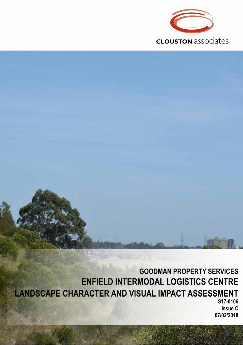
GOODMAN PROPERTY SERVICESENFIELD INTERMODAL LOGISTICS CENTRE
LANDSCAPE CHARACTER AND VISUAL IMPACT ASSESSMENT S17-0106
Issue C07/02/2018

Cover Image:View north towards the site from Punchbowl Road
CLOUSTON AssociatesLandscape Architects • Urban Designers • Landscape Planners65-69 Kent Street • Sydney NSW 2000PO Box R1388 • Royal Exchange NSW 1225 • AustraliaTelephone +61 2 8272 4999 • Facsimile +61 2 8272 4998Contact: Crosbie LorimerEmail • [email protected] • www.clouston.com.au
Prepared by
Goodman Property ServicesLevel 17, 60 Castlereagh StSydney NSW 2000Australia
ENFIELD INTERMODAL LOGISTICS CENTRELANDSCAPE CHARACTER AND VISUAL IMPACT ASSESSMENT
Document Issue Date Status Reviewed Verified ValidatedS17-0106 A 17/01/2018 DRAFT EZ CL -
S17-0106 B 31/01/2018 FINAL EZ CL CL
S17-0106 C 07/02/2018 FINAL EZ CL CL
Note: This document is Preliminary unless validated.
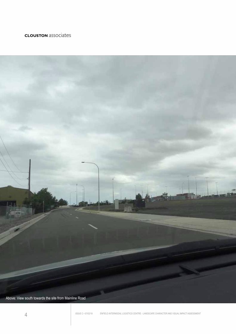
Above: View south towards the site from Mainline Road
ENFIELD INTERMODAL LOGISTICS CENTRE - LANDSCAPE CHARACTER AND VISUAL IMPACT ASSESSMENTISSUE C • 07/02/184
Title page
TABLE OF CONTENTS 5
1.0 INTRODUCTION 6
2.0 THE PROJECT 22
3.0 LANDSCAPE CHARACTER ASSESSMENT 32
4.0 VISUAL IMPACT ASSESSMENT 46
5.0 VISUAL IMPACT MITIGATION RECOMMENDATIONS 82
6.0 CONCLUSIONS 86
APPENDIX A - PHOTOMONTAGES 88
ENFIELD INTERMODAL LOGISTICS CENTRE - LANDSCAPE CHARACTER AND VISUAL IMPACT ASSESSMENT ISSUE C • 07/02/18 5
TABLE OF CONTENTS
ENFIELD INTERMODAL LOGISTICS CENTRE - LANDSCAPE CHARACTER AND VISUAL IMPACT ASSESSMENTISSUE C • 07/02/186
1.0 IN
TROD
UCTI
ON
THE PROJECTGoodman Property Services P/L has commissioned CLOUSTON Associates to prepare a Landscape Character and Visual Impact Assessment (LCVIA) as part of a major Project Proposal for the modification of Enfield Intermodal Logistics Centre near Strathfield South, (hereafter referred to as ‘The Project’).
The Project aims to facilitate the transfer of a growing volume of goods arriving by containers between rail and road..
SCOPE AND LIMITATIONSThis Landscape Character and Visual Impact Assessment (VIA) is comprised of two parts:
– assessment of the potential impact that the proposed works would have on landscape character of the site and locality
– assessment of the visual impact of the new warehouses from principal viewpoints, especially from public domain
The assessment of landscape character and visual impact has been undertaken through site investigation at street level.
It should be noted that the Visual Impact Assessment has been undertaken based on the architect’s 3D modelling and photomontages (illustrated in this report) which, while integral to the overall assessment, do not cover all of the specific views selected for this assessment.
Planning permission has already been granted for a large component of the works covered in this LCVIA Project and thus this current application largely relates to the additional building height proposed. A Visual Impact Assessment was undertake for proposed development works in 2005 (EDAW Gillespies) and this document is referenced where applicable.
1.1.1 VISUAL ASSESSMENT RATIONALEAn LCVIA aims to ensure effects of change and development in the landscape, views and visual amenity are taken into account. It is concerned with how the surroundings of individuals or groups of people may be specifically affected by change in the visual scene, both quantitatively and qualitatively.
Judgement as to the significance of the effects is arrived at by a process of reasoning, based upon analysis of the baseline conditions, identification of visual receptors (viewers of the scene) and assessment of their sensitivity, as well as the magnitude and nature of the changes that may result from any development.
This assessment is an independent report and is based on a professional analysis of the visual environment and the Project at the time of writing. The current and potential future viewers (visual receptors) have not been consulted about their perceptions. The analysis and conclusions are therefore based solely on a professional assessment of the
ENFIELD INTERMODAL LOGISTICS CENTRE - LANDSCAPE CHARACTER AND VISUAL IMPACT ASSESSMENT ISSUE C • 07/02/18 7
1. INTRODUCTION
anticipated impacts, based on a best practice methodology.
1.2 REPORT STRUCTURE The report is divided into the following sections:
1 - INTRODUCTIONAn introduction section that describes the planning and methodology context for the LCVIA.
2 - THE PROJECTA description of the proposed works.
3 - LANDSCAPE CHARACTER ASSESSMENT Assessment of potential impact on each landscape character zone from proposed works.
4 - VISUAL IMPACT ASSESSMENT A study of the visual impacts of the Project. Each of the selected viewpoints are assessed on a range of qualitative and quantitative criteria.
5 - VISUAL IMPACT MITIGATION RECOMMENDATIONSA discussion as to the means by which any visual impacts identified can be precluded, reduced or offset.
6 - CONCLUSIONSConclusions are drawn on the overall visual impact of the Project within the study area and potential view loss from adjoining buildings.
7 - PHOTOMONTAGESPhotomontages from representative viewpoints to reflect the truth of developing
ENFIELD INTERMODAL LOGISTICS CENTRE - LANDSCAPE CHARACTER AND VISUAL IMPACT ASSESSMENTISSUE C • 07/02/188
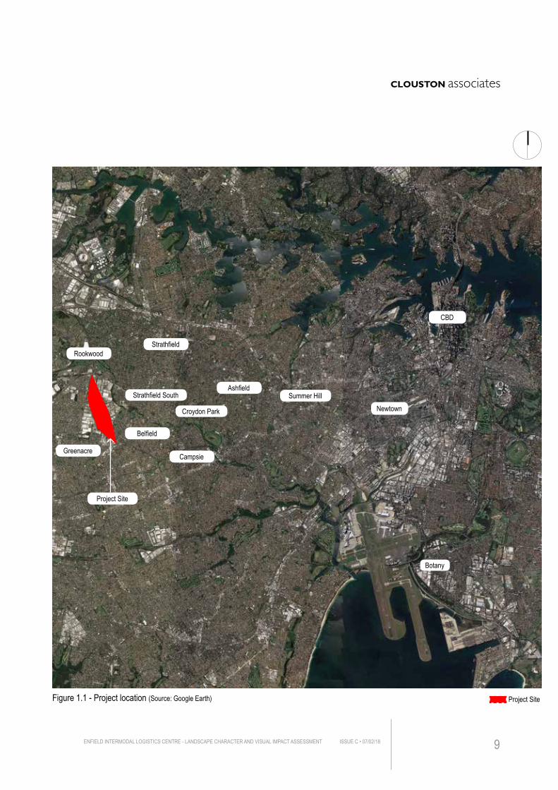
Figure 1.1 - Project location (Source: Google Earth) Project Site
Botany
Newtown
CBD
Greenacre
Project Site
Belfield
RookwoodStrathfield
Campsie
AshfieldSummer Hill
Croydon Park
Strathfield South
ENFIELD INTERMODAL LOGISTICS CENTRE - LANDSCAPE CHARACTER AND VISUAL IMPACT ASSESSMENT ISSUE C • 07/02/18 9
1.3 LEGISLATIVE POLICY AND PLANNING CONTEXTThe planning instruments and guidelines that have the most direct bearing on the visual assessment of the Project include;• Intermodal Logistics Centre at Enfield Visual Assessment, EDAW Gillespies 2005
• A Plan for Growing Sydney 2014
• Draft Central District Plan 2017
• NSW Long Term Transport Master Plan
• NSW Freight and Ports Strategy 2013
• NSW Ports’ 30 Year Master Plan
• Strathfield Local Environmental Plan 2012
• The Land and Environment Court’s Planning Principles (for assessing visual impact and view sharing)
• Environmental Planning and Assessment Act 1979
1.3.1 Intermodal Logistics Centre at Enfield Visual Assessment, EDAW Gillespies 2005 The 2005 VIA assessed the potential visual impacts of the Project from private residences, public spaces and roads. It evaluated the changes to the existing landscape and visual environment and provided corresponding mitigation measures in order to minimise the potential visual impact.
The findings from the 2005 VIA include:• Limited visual impacts from private residences given the extensive industrial land
uses that surround much of the site
• Visual impacts from the selected 19 views where ranked with 13 at Low, 4 at Low/Moderate and 2 at Moderate.
• Impact ratings of Moderate to views along residential street to the site.
A Landscape and Urban Design Masterplan was prepared based on the assessments and findings with particular focus on restricting views towards the site and providing visual amenity benefits (See Figure 1.3 and 1.4)
The selected views and impacts for the 2005 report have been analysed and changes assessed based on the updated development proposal. It should be noted that the proposed mitigation measures for extensive screen planting in the 2005 report have not been adopted in this LCVIA as the proposals for new works under this project supersede these recommendations.
ENFIELD INTERMODAL LOGISTICS CENTRE - LANDSCAPE CHARACTER AND VISUAL IMPACT ASSESSMENTISSUE C • 07/02/1810
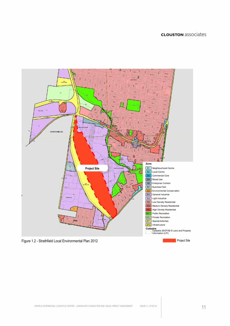
Figure 1.2 - Strathfield Local Environmental Plan 2012 Project Site
Project Site
ENFIELD INTERMODAL LOGISTICS CENTRE - LANDSCAPE CHARACTER AND VISUAL IMPACT ASSESSMENT ISSUE C • 07/02/18 11
1.3.2 A Plan for Growing Sydney 2014Released in December 2014, A Plan for Growing Sydney sets out the goal for the Sydney Metropolitan Area over the next 20 years in terms of guiding Sydney’s productivity and environmental management. The Key relevance issues and actions that in respect of the subject site are:
• Enhance Capacity at Sydney Gateways and Freight Networks
• Enhance the connections in NSW locality
• Establish a competitive economy by adjoining land uses and freight linkages at Enfield Intermodal Logistics Centre
1.3.3 Revised Draft Central District Plan - connecting communities 2017 The Plan frames the potential scheme for the next 40 years to deliver the integrated and effective land use planning and infrastructure delivery through metropolitan and local level planning.
It identifies the Enfield Logistics Centre as a significant concentration of freight activities within South Strathfield, forming a major urban services precinct and promoting the productivity of Metropolitan Sydney.
1.3.4 NSW Long Term Transport Master PlanThe NSW Long Term Transport Master Plan coordinates land use planning in parallel with transport planning including freight connections. One of the key relevant objectives of the Plan is: • Enhance the efficiency and productivity of regional freight through investment
and efficiencies in the road and rail freight networks
1.3.5 NSW Freight and Ports Strategy 2013The NSW Freight and Ports Strategy highlights the significance of freight and aims to ensure freight as a major driving force which stands at the forefront of the NSW economy. It sets out several strategies to achieve the goals including the need to: • Invest heavily in new infrastructure to ensure a greater capacity across the
transport network
• Utilise intermodal terminals across the state to provide value-add services and opportunities with the site, including container storage, light industrial/ commercial area, warehousing and intermodal terminal area.
1.3.6 NSW Ports’ 30 Year Master PlanThe NSW Ports’ 30 Year Master Plan identifies the strength that the Enfield Logistics Centre possesses, which includes the opportunity to:
ENFIELD INTERMODAL LOGISTICS CENTRE - LANDSCAPE CHARACTER AND VISUAL IMPACT ASSESSMENTISSUE C • 07/02/1812
• Provide better connection in between ports and intermodal terminals
• Enhance the efficiency of land use and infrastructure
• Improve the capacity of local port
• Protect the ports and intermodal terminals from urban encroachment.
1.3.7 Strathfield Local Environmental Plan 2012Figure 1.2 illustrates the land uses zones adjoining the Project Site. As may be seen the principal zone is : • IN1 - Industrial
The objectives for this local provision are to: • Provide for infrastructure and related uses
• Prevent development that is not compatible with or that may detract from the provision of infrastructure
• Ensure that development does not have an adverse effect on adjoining land.
1.3.8 The Land and Environment Court Planning PrinciplesThe Land and Environment Court of New South Wales was established in 1980 by the Land and Environment Court Act 1979. Relevant planning principles have been established in visual assessment case judgments over the years to guide future decision-making in development appeals. Whilst a ‘planning principle’ is not binding law, it is described by the Court as a statement of a desirable outcome from a chain of reasoning aimed at reaching a planning decision. These include separate but related principles for private and public domain views.
The principles set out a process for assessing the acceptability of impact. The two most relevant cases to this site are:• Public domain views - Rose Bay Marina Pty Limited v Woollahra Municipal
Council (2013)
• Private views - Tenacity Consulting v Warringah Council (2004)
1.3.9 Environmental Planning and Assessment Act 1979The EP&A Act provides the statutory basis for planning and environmental assessment in NSW. Assessment and approvals may be carried out under various parts of the Act, depending on the requirements of environmental planning instruments, and the scale and nature of impacts of the upgrade work. The Enfield Logistics Centre LCVIA Project is to be assessed for the purpose of obtaining the Secretary’s Environmental Assessment Requirements.
ENFIELD INTERMODAL LOGISTICS CENTRE - LANDSCAPE CHARACTER AND VISUAL IMPACT ASSESSMENT ISSUE C • 07/02/18 13
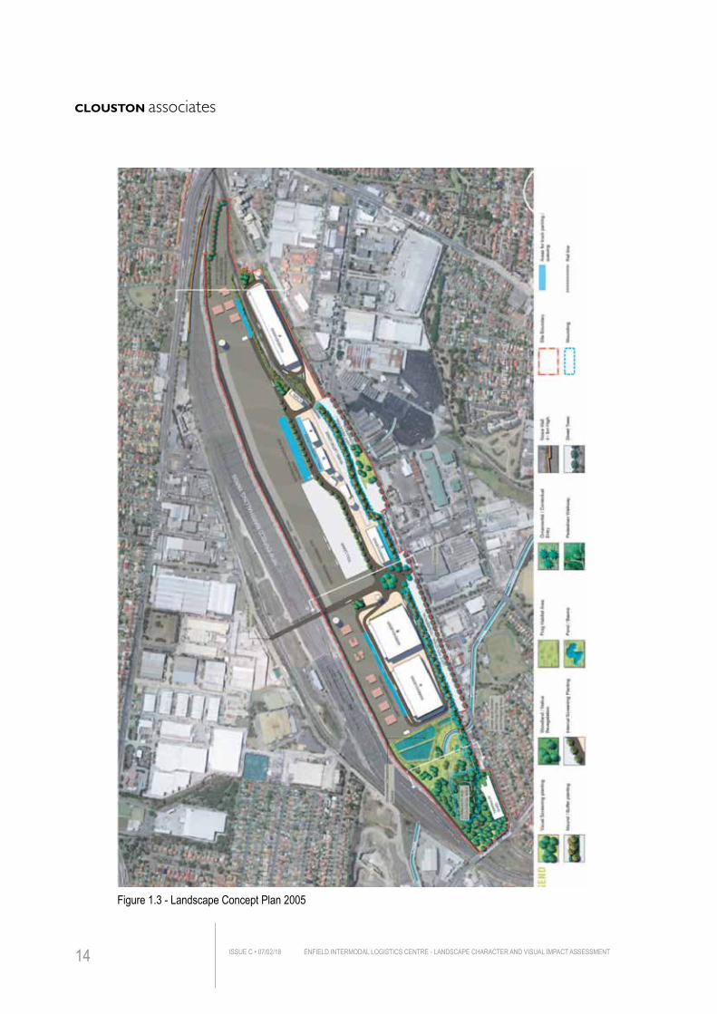
Figure 1.3 - Landscape Concept Plan 2005
ENFIELD INTERMODAL LOGISTICS CENTRE - LANDSCAPE CHARACTER AND VISUAL IMPACT ASSESSMENTISSUE C • 07/02/1814
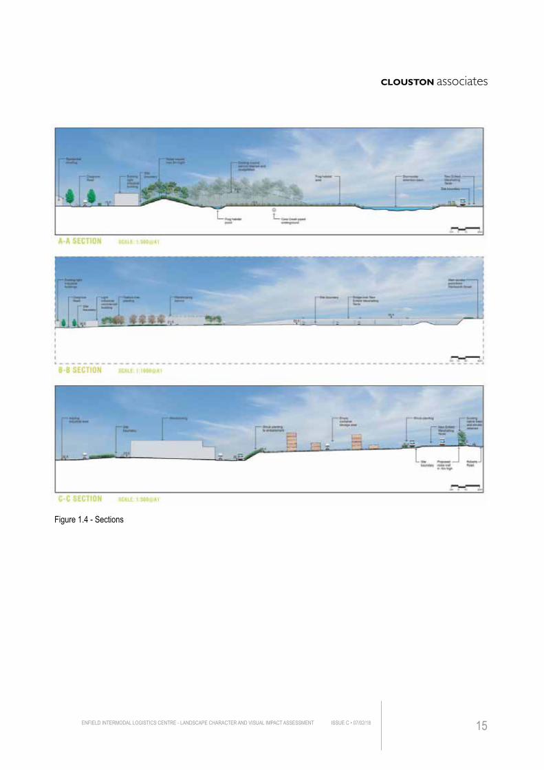
Figure 1.4 - Sections
ENFIELD INTERMODAL LOGISTICS CENTRE - LANDSCAPE CHARACTER AND VISUAL IMPACT ASSESSMENT ISSUE C • 07/02/18 15
1.4 METHODOLOGY - VISUAL IMPACTGiven the subjective nature of an individual’s appreciation of any given scene, Visual Impact Assessment is by its nature not an exact science and consequently methodologies for preparing LCVIAs vary both in Australia and overseas.
Potentially subjective assessment material and differences of opinion about how to best assess visual characteristics, qualities, degrees of alteration and viewer sensitivity often arise.
As a consequence, and as identified by the NSW Land and Environment Court, the key to a robust process is to explain clearly the criteria upon which an assessment is made:
‘The outcome of a qualitative assessment will necessarily be subjective. However, although beauty is inevitably in the eye of the beholder, the framework for how an assessment is undertaken must be clearly articulated. Any qualitative assessment must set out the factors taken into account and the weight attached to them. Whilst minds may differ on outcomes of such an assessment, there should not be issues arising concerning the rigour of the process.’
VIA methodologies are often inconsistent and while various governments have generated specific methodologies, no Australian national framework exists. Within NSW, there are two guidelines prepared by the NSW State Government most relevant to this context and development type that are recognised as best practice are the guidelines for Landscape Character and Visual Impact Assessment, WIA-N04, as published by the Roads and Maritime Service (RMS).
Internationally, the guidelines most broadly considered best practice are guidelines for Landscape and Visual Impact Assessment, 3rd edition, as published by the Landscape Institute UK and IEMA.
In the case of the former guidelines these have been widely adopted through Europe in seeking to meet the EU Directive 2011/92/EU concerning preparation of Environmental Impact Assessment (EIA).
ENFIELD INTERMODAL LOGISTICS CENTRE - LANDSCAPE CHARACTER AND VISUAL IMPACT ASSESSMENTISSUE C • 07/02/1816
1.4.1 ASSESSMENT METHODOLOGYThere are several critical dimensions of an LCVIA demonstrated through this assessment and evaluation:• Ensuring all receptors (viewers) have been adequately identified, even at distance,
with emphasis on public domain views
• Comprehensive evaluation of context to determine visual catchment of site from these areas
• Being clear on and separately defining quantitative impacts (distance, magnitude, duration etc) as against qualitative impacts (viewer type and context of view)
• Providing a clear rationale for how impacts are compared and contrasted
• Ensuring photomontages include views from highest potential impact locations, identified from analysis above
• Being clear on the differing forms of mitigation options, namely avoidance, amelioration (eg design), mitigation (eg screening) and compensation (on or offsite).
The general methodology employed for this assessment is described in Figure 1.5.
A more detailed description of methodology is included within the relevant chapter of Section 3 - Landscape Character Assessment and Section 4 - Visual Impact Assessment.
ENFIELD INTERMODAL LOGISTICS CENTRE - LANDSCAPE CHARACTER AND VISUAL IMPACT ASSESSMENT ISSUE C • 07/02/18 17
ENFIELD INTERMODAL LOGISTICS CENTRE - LANDSCAPE CHARACTER AND VISUAL IMPACT ASSESSMENTISSUE C • 07/02/1818
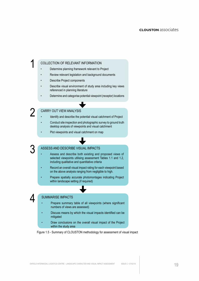
CARRY OUT VIEW ANALYSIS• Identify and describe the potential visual catchment of Project
• Conduct site inspection and photographic survey to ground truth desktop analysis of viewpoints and visual catchment
• Plot viewpoints and visual catchment on map
COLLECTION OF RELEVANT INFORMATION• Determine planning framework relevant to Project
• Review relevant legislation and background documents
• Describe Project components
• Describe visual environment of study area including key views referenced in planning literature
• Determine and categorise potential viewpoint (receptor) locations
ASSESS AND DESCRIBE VISUAL IMPACTS• Assess and describe both existing and proposed views of
selected viewpoints utilising assessment Tables 1.1 and 1.2, including qualitative and quantitative criteria
• Record an overall visual impact rating for each viewpoint based on the above analysis ranging from negligible to high.
• Prepare spatially accurate photomontages indicating Project within landscape setting (if required)
SUMMARISE IMPACTS• Prepare summary table of all viewpoints (where significant
numbers of views are assessed)
• Discuss means by which the visual impacts identified can be mitigated
• Draw conclusions on the overall visual impact of the Project within the study area
1
2
3
4
Figure 1.5 - Summary of CLOUSTON methodology for assessment of visual impact
ENFIELD INTERMODAL LOGISTICS CENTRE - LANDSCAPE CHARACTER AND VISUAL IMPACT ASSESSMENT ISSUE C • 07/02/18 19
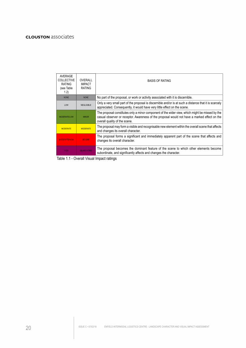
AVERAGE COLLECTIVE
RATING(see Table
1.2)
OVERALL IMPACT RATING
BASIS OF RATING
NONE NONE No part of the proposal, or work or activity associated with it is discernible.
LOW NEGLIGIBLEOnly a very small part of the proposal is discernible and/or is at such a distance that it is scarcely appreciated. Consequently, it would have very little effect on the scene.
MODERATE/LOW MINOR
The proposal constitutes only a minor component of the wider view, which might be missed by the casual observer or receptor. Awareness of the proposal would not have a marked effect on the overall quality of the scene.
MODERATE MODERATEThe proposal may form a visible and recognisable new element within the overall scene that affects and changes its overall character.
MODERATE/HIGH SEVEREThe proposal forms a significant and immediately apparent part of the scene that affects and changes its overall character.
HIGH DEVASTATINGThe proposal becomes the dominant feature of the scene to which other elements become subordinate, and significantly affects and changes the character.
Table 1.1 - Overall Visual Impact ratings
ENFIELD INTERMODAL LOGISTICS CENTRE - LANDSCAPE CHARACTER AND VISUAL IMPACT ASSESSMENTISSUE C • 07/02/1820
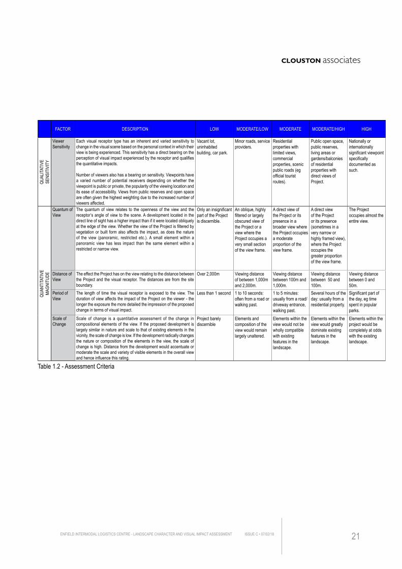
FACTOR DESCRIPTION LOW MODERATE/LOW MODERATE MODERATE/HIGH HIGH
QUAL
ITATI
VESE
NSIT
IVIT
Y
Viewer Sensitivity
Each visual receptor type has an inherent and varied sensitivity to change in the visual scene based on the personal context in which their view is being experienced. This sensitivity has a direct bearing on the perception of visual impact experienced by the receptor and qualifies the quantitative impacts.
Number of viewers also has a bearing on sensitivity. Viewpoints have a varied number of potential receivers depending on whether the viewpoint is public or private, the popularity of the viewing location and its ease of accessibility. Views from public reserves and open space are often given the highest weighting due to the increased number of viewers affected.
Vacant lot, uninhabited building, car park.
Minor roads, service providers.
Residential properties with limited views, commercial properties, scenic public roads (eg official tourist routes).
Public open space, public reserves, living areas or gardens/balconies of residential properties with direct views of Project.
Nationally or internationally significant viewpoint specifically documented as such.
QUAN
TITA
TIVE
MAGN
ITUD
E
Quantum of View
The quantum of view relates to the openness of the view and the receptor’s angle of view to the scene. A development located in the direct line of sight has a higher impact than if it were located obliquely at the edge of the view. Whether the view of the Project is filtered by vegetation or built form also affects the impact, as does the nature of the view (panoramic, restricted etc.). A small element within a panoramic view has less impact than the same element within a restricted or narrow view.
Only an insignificant part of the Project is discernible.
An oblique, highly filtered or largely obscured view of the Project or a view where the Project occupies a very small section of the view frame.
A direct view of the Project or its presence in a broader view where the Project occupies a moderate proportion of the view frame.
A direct view of the Project or its presence (sometimes in a very narrow or highly framed view), where the Project occupies the greater proportion of the view frame.
The Project occupies almost the entire view.
Distance of View
The effect the Project has on the view relating to the distance between the Project and the visual receptor. The distances are from the site boundary.
Over 2,000m Viewing distance of between 1,000m and 2,000m.
Viewing distance between 100m and 1,000m.
Viewing distance between 50 and 100m.
Viewing distance between 0 and 50m.
Period of View
The length of time the visual receptor is exposed to the view. The duration of view affects the impact of the Project on the viewer - the longer the exposure the more detailed the impression of the proposed change in terms of visual impact.
Less than 1 second 1 to 10 seconds: often from a road or walking past.
1 to 5 minutes: usually from a road/driveway entrance, walking past.
Several hours of the day: usually from a residential property.
Significant part of the day, eg time spent in popular parks.
Scale of Change
Scale of change is a quantitative assessment of the change in compositional elements of the view. If the proposed development is largely similar in nature and scale to that of existing elements in the vicinity, the scale of change is low. If the development radically changes the nature or composition of the elements in the view, the scale of change is high. Distance from the development would accentuate or moderate the scale and variety of visible elements in the overall view and hence influence this rating.
Project barely discernible
Elements and composition of the view would remain largely unaltered.
Elements within the view would not be wholly compatible with existing features in the landscape.
Elements within the view would greatly dominate existing features in the landscape.
Elements within the project would be completely at odds with the existing landscape.
Table 1.2 - Assessment Criteria
ENFIELD INTERMODAL LOGISTICS CENTRE - LANDSCAPE CHARACTER AND VISUAL IMPACT ASSESSMENT ISSUE C • 07/02/18 21
ENFIELD INTERMODAL LOGISTICS CENTRE - LANDSCAPE CHARACTER AND VISUAL IMPACT ASSESSMENTISSUE C • 07/02/1822
2.0 T
HE P
ROJE
CT
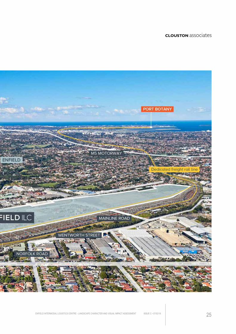
2.1 PROJECT LOCATIONThe Enfield intermodal Logistics Centre is located within Strathfield South and approximately 15 kilometres from the Sydney Central Business District and approximately 18 kilometres away from Port Botany by rail. The current site is primarily bounded by Cosgrove Road to its east, Roberts Road and Wentworth Street to its west, Punchbowl Road to its south. The site covers an area of about 60 hectares.(See Figure 2.1)
2.1 PROJECT DESCRIPTIONThe Enfield Logistics Centre LCVIA Project (“The Project”) involves the development and modifications of existing intermodal terminal to provide operational flexibility and built form outcomes better suited to the demands of prospective tenants and operators, enhancing the overall productivity and efficiency of the site in terms of connections across the freight networks in NSW.
The Enfield Intermodal Logistics Centre will be one of the busiest rail based logistics centre in NSW once completed. To date, only one warehousing has been constructed on site together with a concrete road bridge over the Marshalling Yard. Other elements/constructions on site are: • Intermodal terminals area for loading/uploading shipping containers
• A South Precinct that provides habitat for local fauna and acts as a buffer zone which separates the site and adjacent residential areas
• Tarp shed and locomotive workshop (The Wheel Lathe)
The application includes the following key elements: • Rail facilities including rail sidings and railway lines to better connect to the existing freight line
• Warehouses for storage and distribution (Approx. 13.7m)
• Empty container storage facilities
• Light industrial/ Commercial Area
• Internal roads, administration buildings, stormwater detention and other utilities.
When completed, the Centre will provide greater flexibility and better serve the Greater Sydney port supply chain 24/7.
The major change to the new application that would potentially affect the visual environment is the increased height of the proposed warehouses to a maximum of 13.7m (See Table 2.1). This would result in a different visual experience from either private properties or publicly accessible spaces. A landscape concept has been prepared and coordinated with architects to provide screening to the proposed built form (See Figure 2.4).
2.2 SITE CONTEXTThe Project is situated on land in the Sydney suburb of Strathfield South and it is located within a locality that surrounded by the suburbs of Greenacre and Chullora to the west, Belfield to the south, Rookwood to the north and South Strathfield to its east.
The site adjoins the New Marshalling Yard, railway lines and industrial development on the west and east, as well as residential areas to the south and south east.
ENFIELD INTERMODAL LOGISTICS CENTRE - LANDSCAPE CHARACTER AND VISUAL IMPACT ASSESSMENT ISSUE C • 07/02/18 23
2. THE PROJECT
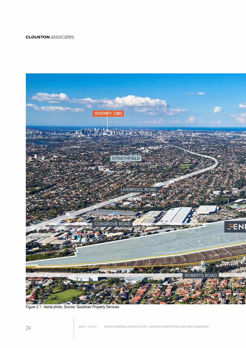
Figure 2.1 - Aerial photo, Source: Goodman Property Services
ENFIELD INTERMODAL LOGISTICS CENTRE - LANDSCAPE CHARACTER AND VISUAL IMPACT ASSESSMENTISSUE C • 07/02/1824
ENFIELD INTERMODAL LOGISTICS CENTRE - LANDSCAPE CHARACTER AND VISUAL IMPACT ASSESSMENT ISSUE C • 07/02/18 25
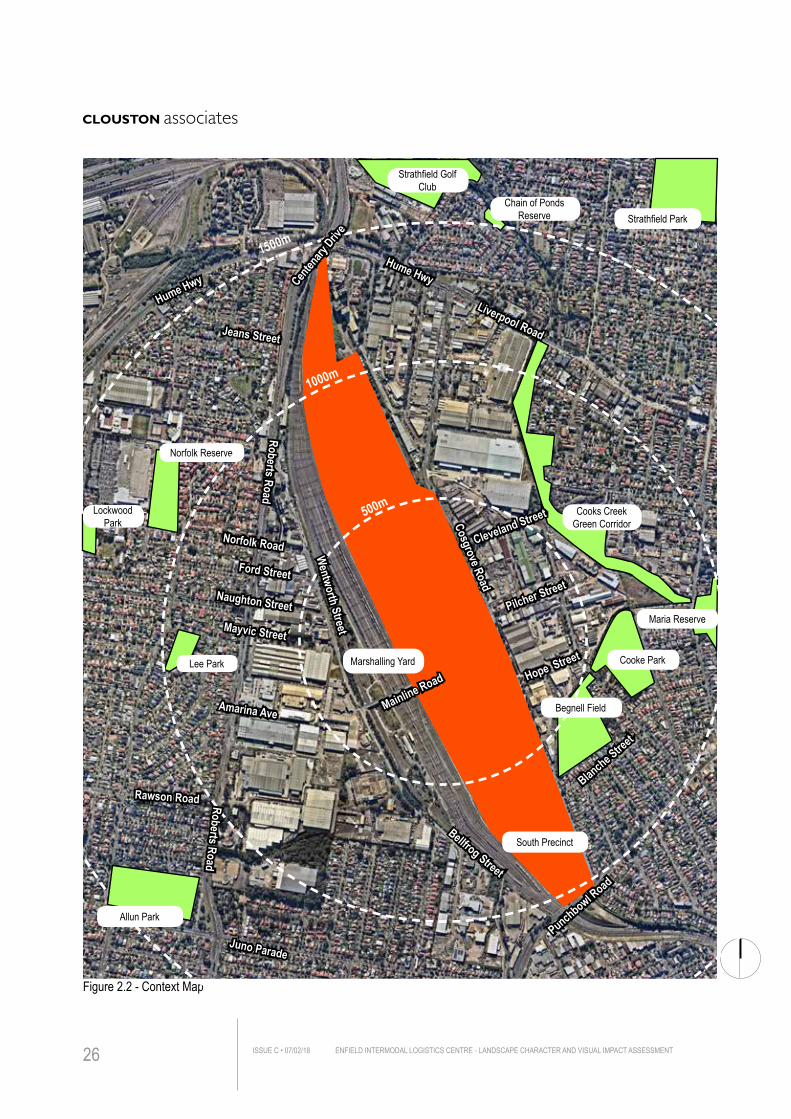
Figure 2.3 - Proposed Building Layout Plan - Roof Level
Figure 2.2 - Context Map
Cooke Park
Strathfield Golf Club
Cooks Creek Green CorridorCosgrove Road
Punchbowl Road
Juno Parade
Blanche Street
Hume Hwy
Hume Hwy
Liverpool Road
Lee Park
Lockwood Park
Maria Reserve
Strathfield Park
Norfolk Reserve
Roberts RoadNorfolk Road
Jeans Street
Rawson Road
Ford Street
Mayvic Street
Amarina Ave
Hope Street
Pilcher Street
500m
1000m
1500m
Wentworth Street
Mainline Road
Bellfrog Street
Naughton Street
Roberts Road
South Precinct
Begnell Field
Marshalling Yard
Cleveland Street
Chain of Ponds Reserve
Allun Park
Centen
ary Driv
e
ENFIELD INTERMODAL LOGISTICS CENTRE - LANDSCAPE CHARACTER AND VISUAL IMPACT ASSESSMENTISSUE C • 07/02/1826
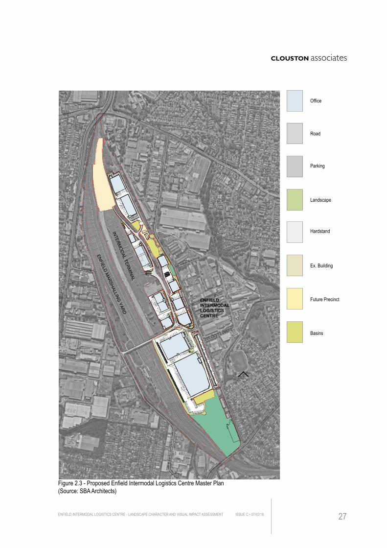
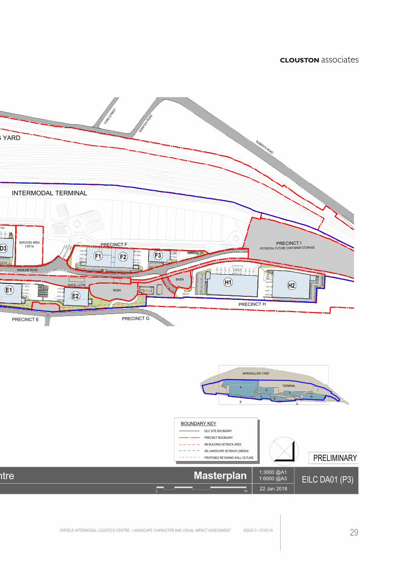
Figure 2.3 - Proposed Enfield Intermodal Logistics Centre Master Plan(Source: SBA Architects)
INTER
MO
DAL
TERM
INAL
ENFIELDM
ARSHALLINGYARD
ENFIELDINTERMODAL LOGISTICS CENTRE
WAREHOUSE OFFICE ROAD PARKING LANDSCAPE HARDSTAND SEWAGE PONDS SERVICES EX. BUILDING FUTURE PRECINCT
PRELIMINARY
SBARCHITECTS 22 Jan 2018
1 : 6000 @A1
EILC DA00 (P3)1: 12000 @A3
Mainline Rd, Strathfield South
Enfield Intermodal Logistics Centre Cover Sheet
PROPOSED ENFIELD INTERMODAL LOGISTICS CENTREPRECINCT A,B,C,D,E,F,G,H, AND ICosgrove Road, Enfield, NSW 2136
DRAWING LISTMasterplanEILC DA00 - Cover SheetEILC DA01 - Masterplan EILC DA02 - Sub-Division PlanEILC DA03 - Precinct A, B, C, D, & EEILC DA04 - Precinct E, F, G, H, & I
Precinct A & BEILC DA10 - Precincts A & B Site Plan
Precinct CEILC DA20 - Precinct C - Site Plan
Precinct DEILC DA30 - Precinct D - Site Plan
Precinct EEILC DA40 - Precinct E - Site Plan
Precinct FEILC DA50 - Precinct F - Site Plan
Precinct HEILC DA60 - Precinct H - Site Plan
RevisionP3P3P2P3P3
P3
P3
P3
P3
P3
P3
Office
Road
Parking
Landscape
Hardstand
Ex. Building
Future Precinct
Basins
ENFIELD INTERMODAL LOGISTICS CENTRE - LANDSCAPE CHARACTER AND VISUAL IMPACT ASSESSMENT ISSUE C • 07/02/18 27
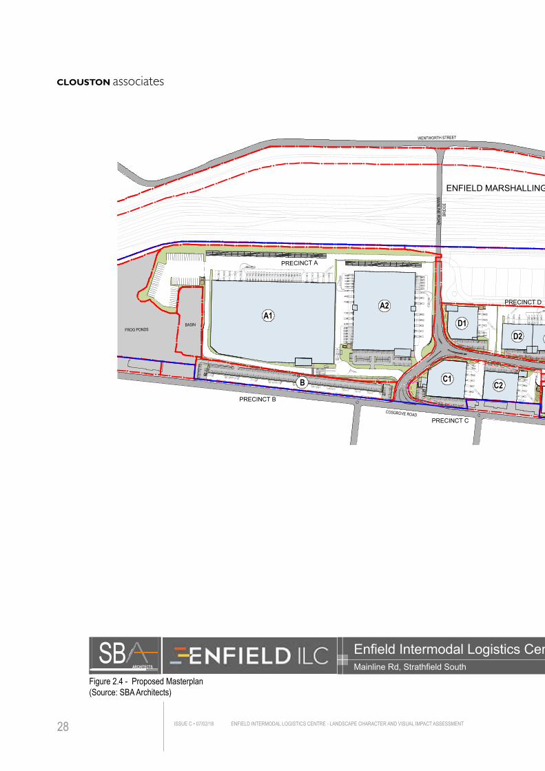
Figure 2.4 - Proposed Masterplan(Source: SBA Architects)
ENFIELD INTERMODAL LOGISTICS CENTRE - LANDSCAPE CHARACTER AND VISUAL IMPACT ASSESSMENTISSUE C • 07/02/1828
FROG PONDS
PRECINCT A
PRECINCT B
BASIN
PRECINCT C
PRECINCT D
PRECINCT E
PRECINCT F
PRECINCT G
PRECINCT H
PRECINCT I
WHEEL LATHEBASIN
BASIN
MAINLINE ROAD
COSGROVE ROAD
INTERMODAL TERMINAL
ENFIELD MARSHALLING YARD
WENTWORTH STREET
MAINLINEROAD
BRID
GE
SERVICES AREA0.85 ha
A1A2
C1C2
D1
F1 F2 F3
H1 H2E1
E2
B
POTENTIAL FUTURE CONTAINER STORAGE
NORF
OLKRO
AD
FORD
STRE
ET
ROBERTS ROAD
D2 D3
BOUNDARY KEY
2M LANDSCAPE SETBACK (GREEN)
6M BUILDING SETBACK (RED)
PRECINCT BOUNDARY
EILC SITE BOUNDARY
PROPOSED RETAINING WALL OUTLINE
A
BC
D
E
FH
I
G
MARSHALLING YARD
TERMINAL
PRELIMINARY
SBARCHITECTS 22 Jan 2018
1:3000 @A1
EILC DA01 (P3)1:6000 @A3
Mainline Rd, Strathfield South
Enfield Intermodal Logistics Centre Masterplan
Site Area ScheduleTotal Site Area 59.32 haLess:
RoadsEcological ZonesBasinsIntermodal Terminal & RailwayServices AreaWheel Lathe & Railway
Site Area (ha)
2.986.721.51
14.610.851.47
Development Areas
ABCDEFGHI
Precincts Lots
6,121
2,7233,48,9181013
13.021.492.112.542.192.070.373.583.81
Site Area (ha)
31.18 haNon Developable
62,6007,384
10,48711,460
7,6049,620
N/A16,475
N/A
GLA (m²)
125,630m²28.14 ha
Car Parking
3239389957069
N/A109N/A
848Total Developable
0 300
ENFIELD INTERMODAL LOGISTICS CENTRE - LANDSCAPE CHARACTER AND VISUAL IMPACT ASSESSMENT ISSUE C • 07/02/18 29
FROG PONDS
PRECINCT A
PRECINCT B
BASIN
PRECINCT C
PRECINCT D
PRECINCT E
PRECINCT F
PRECINCT G
PRECINCT H
PRECINCT I
WHEEL LATHEBASIN
BASIN
MAINLINE ROAD
COSGROVE ROAD
INTERMODAL TERMINAL
ENFIELD MARSHALLING YARD
WENTWORTH STREET
MAINLINEROAD
BRID
GE
SERVICES AREA0.85 ha
A1A2
C1C2
D1
F1 F2 F3
H1 H2E1
E2
B
POTENTIAL FUTURE CONTAINER STORAGE
NORF
OLKRO
AD
FORD
STRE
ET
ROBERTS ROAD
D2 D3
BOUNDARY KEY
2M LANDSCAPE SETBACK (GREEN)
6M BUILDING SETBACK (RED)
PRECINCT BOUNDARY
EILC SITE BOUNDARY
PROPOSED RETAINING WALL OUTLINE
A
BC
D
E
FH
I
G
MARSHALLING YARD
TERMINAL
PRELIMINARY
SBARCHITECTS 22 Jan 2018
1:3000 @A1
EILC DA01 (P3)1:6000 @A3
Mainline Rd, Strathfield South
Enfield Intermodal Logistics Centre Masterplan
Site Area ScheduleTotal Site Area 59.32 haLess:
RoadsEcological ZonesBasinsIntermodal Terminal & RailwayServices AreaWheel Lathe & Railway
Site Area (ha)
2.986.721.51
14.610.851.47
Development Areas
ABCDEFGHI
Precincts Lots
6,121
2,7233,48,9181013
13.021.492.112.542.192.070.373.583.81
Site Area (ha)
31.18 haNon Developable
62,6007,384
10,48711,460
7,6049,620
N/A16,475
N/A
GLA (m²)
125,630m²28.14 ha
Car Parking
3239389957069
N/A109N/A
848Total Developable
0 300
ENFIELD INTERMODAL LOGISTICS CENTRE - LANDSCAPE CHARACTER AND VISUAL IMPACT ASSESSMENTISSUE C • 07/02/1830
NSW Ports Board Presentation | October 2017 7
ENFIELD ILC
DESIGN INTENT
NSW Ports Board Presentation | October 2017 8
ENFIELD ILC
DESIGN INTENT
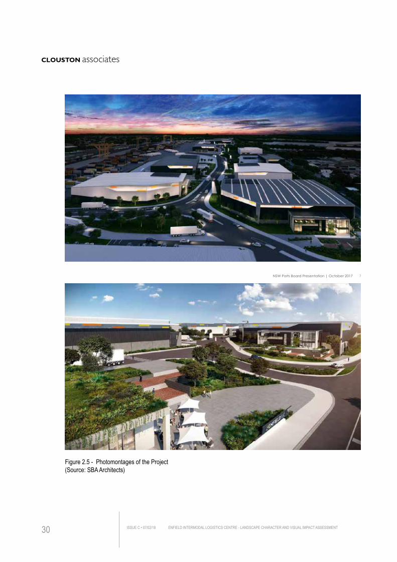
Figure 2.5 - Photomontages of the Project(Source: SBA Architects)
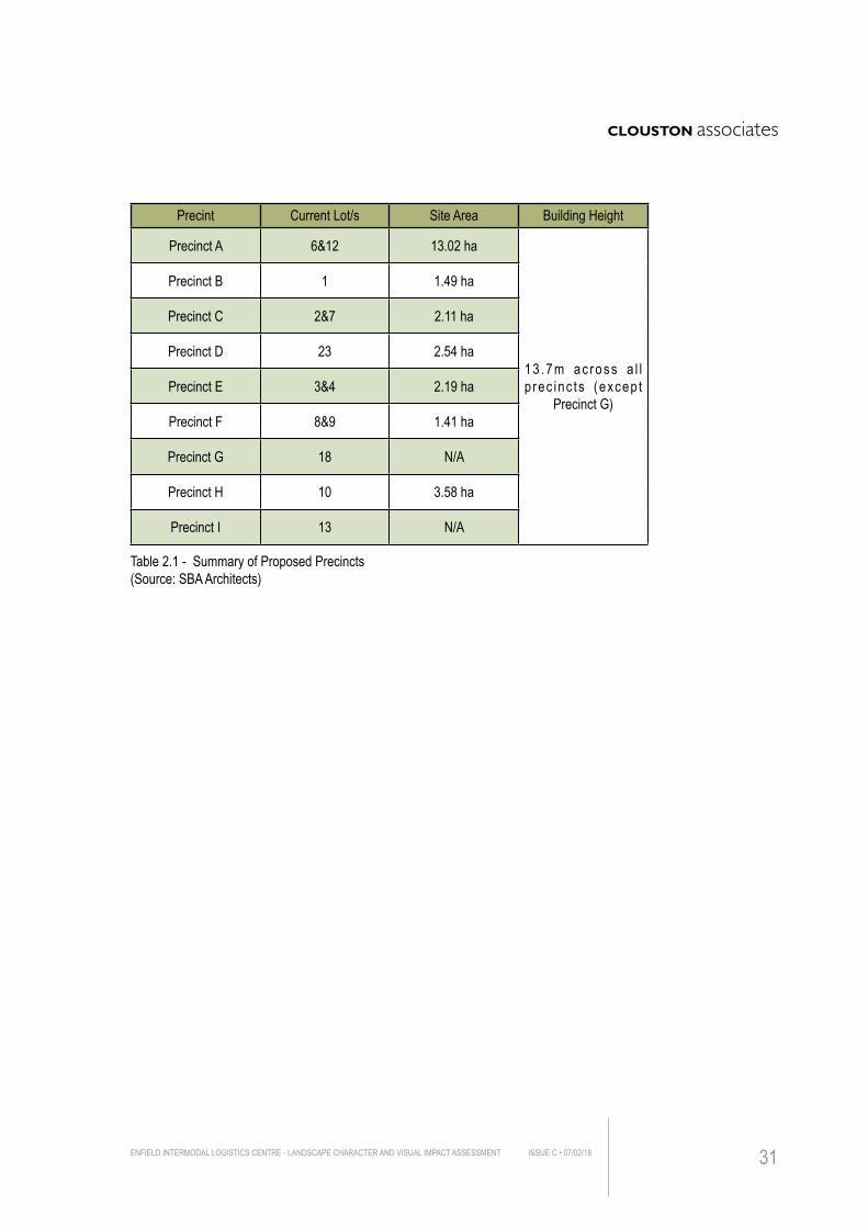
Precint Current Lot/s Site Area Building Height
Precinct A 6&12 13.02 ha
13 .7m ac ross a l l p rec inc ts (excep t
Precinct G)
Precinct B 1 1.49 ha
Precinct C 2&7 2.11 ha
Precinct D 23 2.54 ha
Precinct E 3&4 2.19 ha
Precinct F 8&9 1.41 ha
Precinct G 18 N/A
Precinct H 10 3.58 ha
Precinct I 13 N/A
Table 2.1 - Summary of Proposed Precincts(Source: SBA Architects)
ENFIELD INTERMODAL LOGISTICS CENTRE - LANDSCAPE CHARACTER AND VISUAL IMPACT ASSESSMENT ISSUE C • 07/02/18 31
ENFIELD INTERMODAL LOGISTICS CENTRE - LANDSCAPE CHARACTER AND VISUAL IMPACT ASSESSMENTISSUE C • 07/02/1832
3.0 E
XIST
ING
VISU
AL E
NVIR
ONME
NT
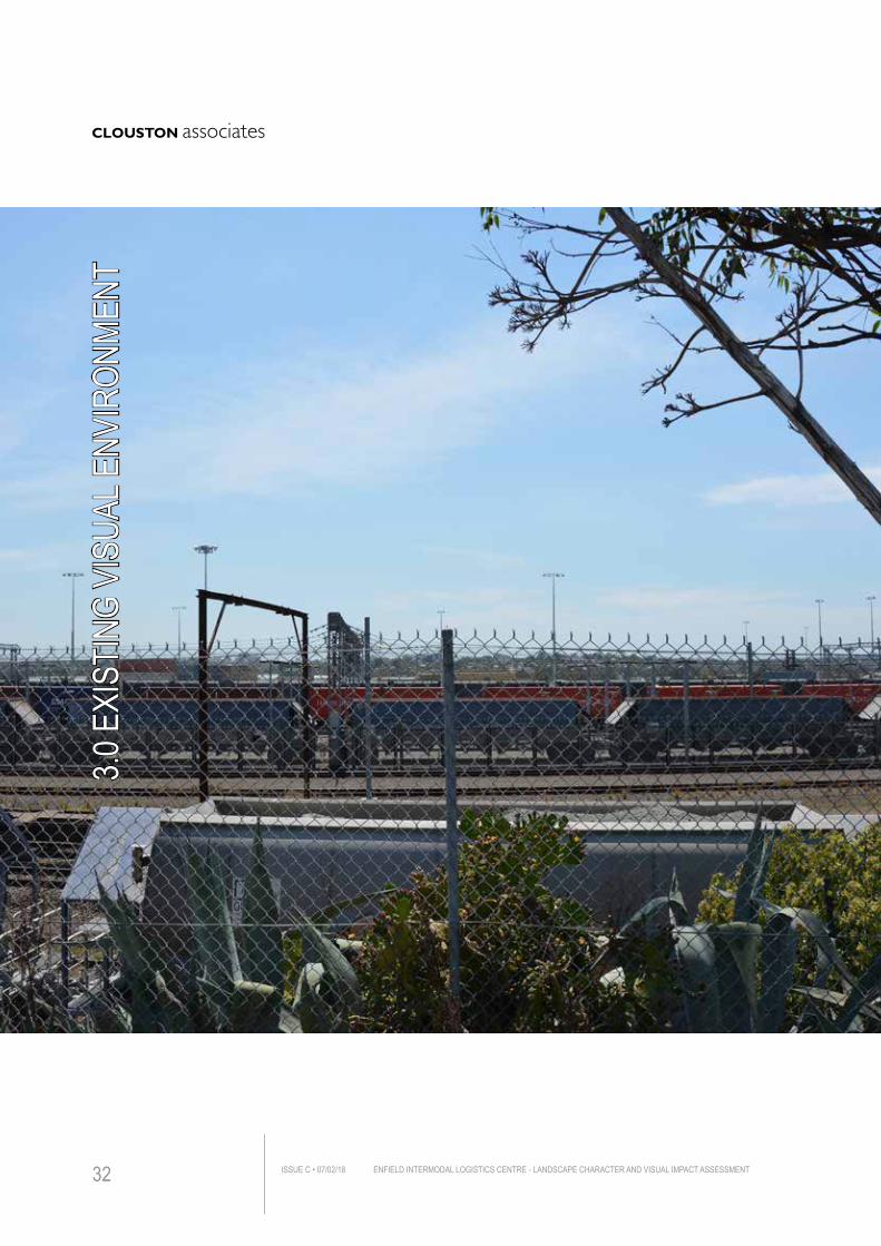
3.0 EXISTING LANDSCAPE CHARACTERThe site itself is predominantly industrial in nature, comprising of a series of buildings, warehouses, marshalling yard, stacked containers, intermodal terminal areas and southern precinct.
It is zoned IN1 (General industrial) under the Strathfield Local Environmental Plan 2012 (See Figure 1.2). The site is mostly flat with large levelled areas prepared for new warehouses and other associated facilities. There are existing buildings scattered across the site with limited vegetation surrounding them. The new proposal would be an improvement on the southern portion of the site, adjacent to new warehouses A1 and A2, where an empty container area was initially proposed.
Southern Precinct provides marginal habitat for local fauna particularly Green and Golden Bell Frog. It will assist in mitigating further disturbances that may result from the development of the Intermodal Logistics Centre. (See Figure 2.1)
The site lies within an area of industrial and residential landuses, mostly on flat to undulating topography (Southern precinct is a prominent landform). As part of the site, a Marshalling Yard borders the site immediately to the west, providing freight transport services for site users.
A large area of industrial and commercial businesses is located between Roberts Road and Wentworth Street, while the area adjoining the site to the south west and south east are predominantly residential. The area to the south comprises of a mix of residential, commercial and industrial development.
Along the eastern perimeter of the site it is predominantly a mixture of light industrial and commercial development with a range of multistorey buildings. Residential properties lie further east of the industrial development.
Coxs Creek associated with its green corridor and open spaces (Begnell Field and Cooke Park) separates the residential area from this large industrial area in Strathfield South, largely obscuring the view towards the site. Part of this creek is channelised. Figure 3.1 identifies the principal land uses and associated landscape character around the study area.
3.1 ON SITE VEGETATIONOn site vegetation is mostly limited in extent, comprised largely of:• roadside tree planting (Along Mainline Road and Cosgrove Road)
• shrubs and groundcovers (Close to Cosgrove Road, on the eastern part of the site)
• open grassland (West to the Marshalling Yard, northern part of the site)
• a mix of trees, shrubs and groundcovers within Southern Precinct (Southern part of the site)
ENFIELD INTERMODAL LOGISTICS CENTRE - LANDSCAPE CHARACTER AND VISUAL IMPACT ASSESSMENT ISSUE C • 07/02/18 33
3. LANDSCAPE CHARACTER ASSESSMENT
3.2 LANDSCAPE CHARACTER ZONESTo enable the assessment of impacts on landscape character, the landscape character zones have been determined for the Project Area. This report has adopted the Guidelines for Landscape Character and Visual Impact Assessment as published by RMS.
Landscape character zones are defined as areas having a distinct, recognisable and consistent pattern of elements, be they natural (soil, vegetation, landform) and/or built form, making one landscape different from another. The Project area and surrounds have been assessed and several landscape character zones have been established (refer Figure 3.1).
3.2.1 SensitivitySensitivity is the degree to which a particular landscape type can accommodate change arising from a development, without detrimental effects on its character. This includes factors such as:• existing land use
• the pattern and scale of the landscape
• visual enclosure, openness of views and distribution of visual receptors
• the value placed on the landscape.
Areas with a high sensitivity to change include zones with substantial natural landscape features, natural landscape types with inherent natural values and landscapes with heritage or cultural values.
3.2.2 MagnitudeMagnitude refers to the scale of the effects of the development within the landscape. Consideration is given to:• existing built form in the landscape and how closely the development matches
this in bulk, scale and form
• the scale or degree of change to the landscape resource
• the nature of the effect and its duration including whether it is permanent or temporary.
3.2.3 Overall Impact RatingThe overall impact rating of the Project on any given landscape character zone is based on themes of magnitude and sensitivity. The severity of these impacts are calculated using Table 3.1 - based on a combination of magnitude and sensitivity to find a final impact rating - Table 3.2.
ENFIELD INTERMODAL LOGISTICS CENTRE - LANDSCAPE CHARACTER AND VISUAL IMPACT ASSESSMENTISSUE C • 07/02/1834
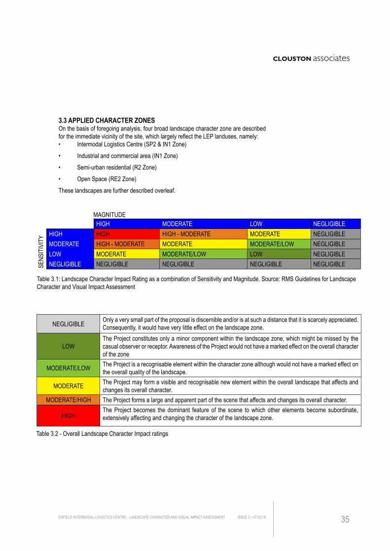
3.3 APPLIED CHARACTER ZONESOn the basis of foregoing analysis, four broad landscape character zone are described for the immediate vicinity of the site, which largely reflect the LEP landuses, namely: • Intermodal Logistics Centre (SP2 & IN1 Zone)
• Industrial and commercial area (IN1 Zone)
• Semi-urban residential (R2 Zone)
• Open Space (RE2 Zone)
These landscapes are further described overleaf.
Table 3.1: Landscape Character Impact Rating as a combination of Sensitivity and Magnitude. Source: RMS Guidelines for Landscape Character and Visual Impact Assessment
HIGH MODERATE LOW NEGLIGIBLEHIGH HIGH HIGH - MODERATE MODERATE NEGLIGIBLEMODERATE HIGH - MODERATE MODERATE MODERATE/LOW NEGLIGIBLELOW MODERATE MODERATE/LOW LOW NEGLIGIBLENEGLIGIBLE NEGLIGIBLE NEGLIGIBLE NEGLIGIBLE NEGLIGIBLESE
NSIT
IVIT
Y
MAGNITUDE
Table 3.2 - Overall Landscape Character Impact ratings
NEGLIGIBLE Only a very small part of the proposal is discernible and/or is at such a distance that it is scarcely appreciated. Consequently, it would have very little effect on the landscape zone.
LOWThe Project constitutes only a minor component within the landscape zone, which might be missed by the casual observer or receptor. Awareness of the Project would not have a marked effect on the overall character of the zone
MODERATE/LOW The Project is a recognisable element within the character zone although would not have a marked effect on the overall quality of the landscape.
MODERATE The Project may form a visible and recognisable new element within the overall landscape that affects and changes its overall character.
MODERATE/HIGH The Project forms a large and apparent part of the scene that affects and changes its overall character.
HIGHThe Project becomes the dominant feature of the scene to which other elements become subordinate, extensively affecting and changing the character of the landscape zone.
ENFIELD INTERMODAL LOGISTICS CENTRE - LANDSCAPE CHARACTER AND VISUAL IMPACT ASSESSMENT ISSUE C • 07/02/18 35
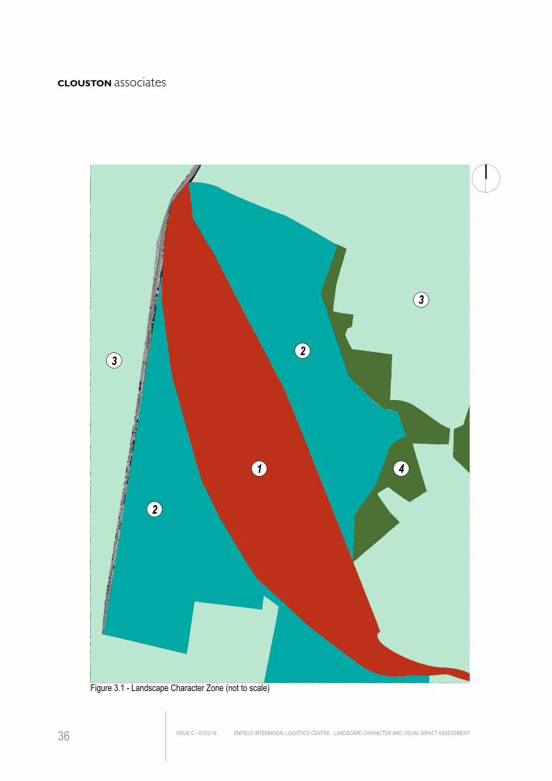
Figure 3.1 - Landscape Character Zone (not to scale)
3
32
2
1 4
ENFIELD INTERMODAL LOGISTICS CENTRE - LANDSCAPE CHARACTER AND VISUAL IMPACT ASSESSMENTISSUE C • 07/02/1836
Figure 3.2 - Landscape Character Zone (Photographs)
Zone 1 - Intermodal Logistics Centre (SP2 & IN1 Zone)
Zone 2 - Industrial and Commerical Area (IN1 Zone)
Zone 3 - Low Rise Residential Area (R2 Zone)
Zone 4 - Open Spaces (RE2 Zone)
ENFIELD INTERMODAL LOGISTICS CENTRE - LANDSCAPE CHARACTER AND VISUAL IMPACT ASSESSMENT ISSUE C • 07/02/18 37
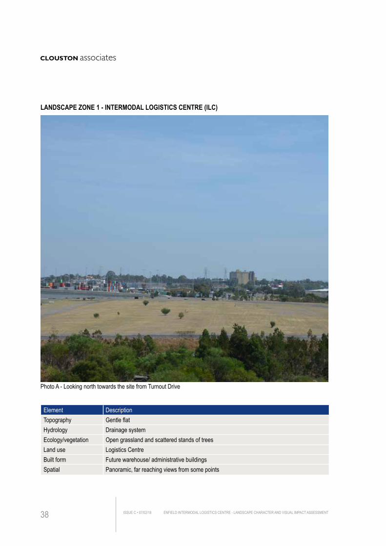
Element DescriptionTopography Gentle flatHydrology Drainage systemEcology/vegetation Open grassland and scattered stands of treesLand use Logistics CentreBuilt form Future warehouse/ administrative buildingsSpatial Panoramic, far reaching views from some points
Photo A - Looking north towards the site from Turnout Drive
LANDSCAPE ZONE 1 - INTERMODAL LOGISTICS CENTRE (ILC)
ENFIELD INTERMODAL LOGISTICS CENTRE - LANDSCAPE CHARACTER AND VISUAL IMPACT ASSESSMENTISSUE C • 07/02/1838
DESCRIPTIONThe Intermodal Logistics Centre (ILC) was a distinct landscape characteristic as large mostly open and level space punctuated by buildings, container stacks and the associated infrastructure.
The existing built form includes one warehouse and several administrative buildings scattered through the site with limited vegetation surrounding them. The new Marshalling Yard is on the eastern side of ILC. A number of large open cleared areas are levelled and prepared for the construction of new warehouses and associated facilities. ASSESSMENTSensitivity
Given that the nature of existing site is already industrial with minimal vegetation that would be required to be removed, the sensitivity of this zone has a Moderate rating to the proposal.
Magnitude
The magnitude of the proposal in this landscape character zone is considered to be Moderate as the proposed construction would be similar to existing visual environment. The character zone has a relatively high ability to absorb similar change without altering its character.
Summary
Overall, a Moderate impact is expected on the character of this zone due to the scale and type of proposed built form.
Sensitivity MODERATE
Magnitude MODERATE
Overall Landscape Character Impact Rating MODERATEFrom Table 3.1, using a combination of sensitivity and magnitude ratings.
ENFIELD INTERMODAL LOGISTICS CENTRE - LANDSCAPE CHARACTER AND VISUAL IMPACT ASSESSMENT ISSUE C • 07/02/18 39
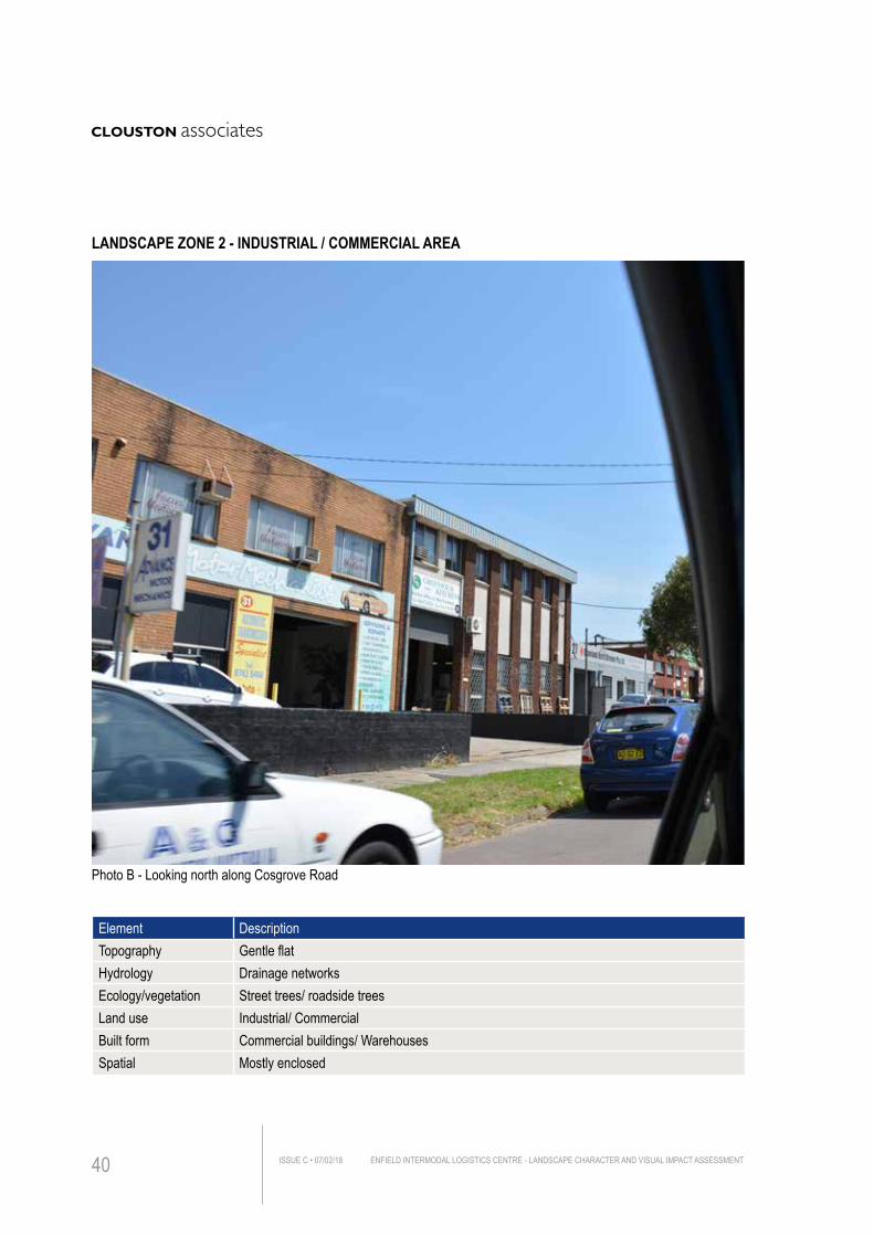
Element DescriptionTopography Gentle flat Hydrology Drainage networksEcology/vegetation Street trees/ roadside trees Land use Industrial/ Commercial Built form Commercial buildings/ WarehousesSpatial Mostly enclosed
Photo B - Looking north along Cosgrove Road
LANDSCAPE ZONE 2 - INDUSTRIAL / COMMERCIAL AREA
ENFIELD INTERMODAL LOGISTICS CENTRE - LANDSCAPE CHARACTER AND VISUAL IMPACT ASSESSMENTISSUE C • 07/02/1840
DESCRIPTIONDevelopment in this zone consists primarily of larger buildings including commercial stores, warehouses and storage facilities. Sparse and fragmented tree groups are scattered through this landscape character zone. Large built form and the flat topography limits the majority of views towards the site from this area.
Part of the area along Wentworth Street has visual access to the site and any new development would stand out relatively clear. However, the nature of existing landscape character will not be altered as the Project is in keeping with the same character as existing visual environment. ASSESSMENTSensitivity
This character zone constitutes a high level of urban development with associated infrastructure and numerous large commercial and industrial buildings, the landscape character therefore has a high ability to absorb change, leading to a Low sensitivity rating.
Magnitude
The Project is expected to have limited landscape character impact on this zone as the scale and bulk of the proposed development is of a similar magnitude of existing infrastructure elements within the wider study area. The Project deemed to have a Low magnitude within this landscape zone.
Summary
Overall, a Low impact is expected on the character of this zone as most of views would be blocked by existing built form.
Sensitivity LOW
Magnitude LOW
Overall Landscape Character Impact Rating LOWFrom Table 3.1, using a combination of sensitivity and magnitude ratings.
ENFIELD INTERMODAL LOGISTICS CENTRE - LANDSCAPE CHARACTER AND VISUAL IMPACT ASSESSMENT ISSUE C • 07/02/18 41
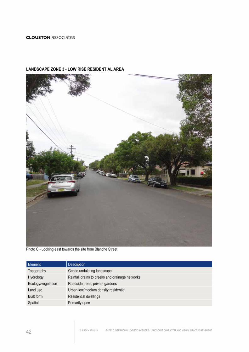
Element DescriptionTopography Gentle undulating landscapeHydrology Rainfall drains to creeks and drainage networksEcology/vegetation Roadside trees, private gardensLand use Urban low/medium density residentialBuilt form Residential dwellings Spatial Primarily open
Photo C - Looking east towards the site from Blanche Street
LANDSCAPE ZONE 3 - LOW RISE RESIDENTIAL AREA
ENFIELD INTERMODAL LOGISTICS CENTRE - LANDSCAPE CHARACTER AND VISUAL IMPACT ASSESSMENTISSUE C • 07/02/1842
DESCRIPTIONResidential development in the area is mostly typified by single and double storey detached properties in a low/medium density. Locality vegetation is mostly limited to roadside trees and areas of public open space. The density of built form along with street tree planting largely obscures the view towards the site, limiting visual accessibility to receptors at the edge of the residential development even on elevated ground. The development of the site will have limited impacts on the landscape characters in these residential areas.
ASSESSMENTSensitivity
This landscape zone constitutes a low/medium density of residential development. Very limited number of receptors have visual connection to the site and residential dwellings with associated street tree planting largely screen long distance views.
This zone is capable of absorbing changes without altering the existing visual context and therefore, it is described as a Moderate/Low sensitivity to change.
Magnitude
The Project is not expected to have any substantial impacts on this character zone. The proposed construction would be highly screened by built form and vegetation groups. A Low magnitude of change is therefore expected for this landscape zone.
Summary
Overall, a Low impact has been recorded on this character zone. The Project would not have any direct impact on the landscape character of any residential areas.
Sensitivity MODERATE/LOW
Magnitude LOW
Overall Landscape Character Impact Rating LOWFrom Table 3.1, using a combination of sensitivity and magnitude ratings.
ENFIELD INTERMODAL LOGISTICS CENTRE - LANDSCAPE CHARACTER AND VISUAL IMPACT ASSESSMENT ISSUE C • 07/02/18 43
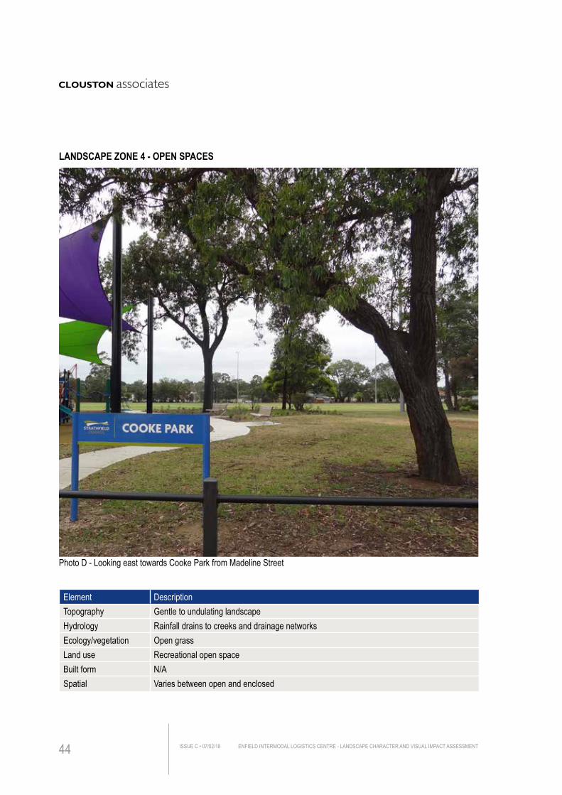
Element DescriptionTopography Gentle to undulating landscapeHydrology Rainfall drains to creeks and drainage networksEcology/vegetation Open grassLand use Recreational open spaceBuilt form N/ASpatial Varies between open and enclosed
Photo D - Looking east towards Cooke Park from Madeline Street
LANDSCAPE ZONE 4 - OPEN SPACES
ENFIELD INTERMODAL LOGISTICS CENTRE - LANDSCAPE CHARACTER AND VISUAL IMPACT ASSESSMENTISSUE C • 07/02/1844
DESCRIPTIONThe landscape of this character zone are largely located primarily on the eastern side of the Project in between the industrial development and residential area. The public open space is comprised of both passive recreation facilities and sports field, as well as green corridor adjacent to Cooks Creek.
ASSESSMENTSensitivity
This zone has a general absence of built form, with presence of mature vegetation within an open landscape. Construction on Project site will not have the potential for adverse impact on this landscape character as the built form in the foreground will completely obscure the view. This character is described to have a Moderate/Low sensitivity to change.
Magnitude
The Project will not be visible from public open space and therefore it is deemed as having a Low magnitude rating within this zone.
Summary
Overall, a Low impact rating has been recorded on this landscape zone. There will be no impact on this character as no new buildings will be evident in this landscape.
Sensitivity MODERATE/LOW
Magnitude LOW
Overall Landscape Character Impact Rating LOWFrom Table 3.1, using a combination of sensitivity and magnitude ratings.
ENFIELD INTERMODAL LOGISTICS CENTRE - LANDSCAPE CHARACTER AND VISUAL IMPACT ASSESSMENT ISSUE C • 07/02/18 45
ENFIELD INTERMODAL LOGISTICS CENTRE - LANDSCAPE CHARACTER AND VISUAL IMPACT ASSESSMENTISSUE C • 07/02/1846
4.0 V
ISUA
L IMP
ACT A
SSES
SMEN
T
4.1 EXISTING VISUAL ENVIRONMENT
4.1.1 Private domainGiven the relatively flat landform of the site ad its immediate surrounds, the site is generally of low visibility from the majority of residential properties and public open spaces in the vicinity. Views towards the site are mostly obscured by a combination of built form, topography and screening vegetation.
Some more distant views to the site may be had from the north and northwest, that these views are largely at distance and the views already comprised significant industrial development.
4.1.2 Public domainThe site is primarily visible along the Wentworth Street and Cosgrove Road, adjoining industrial and commercial areas. It is also partially visible from Roberts Road through the gap of screening planting. However, the majority of publicly accessible places do not provide views to the site because of the foreground built form and vegetation.
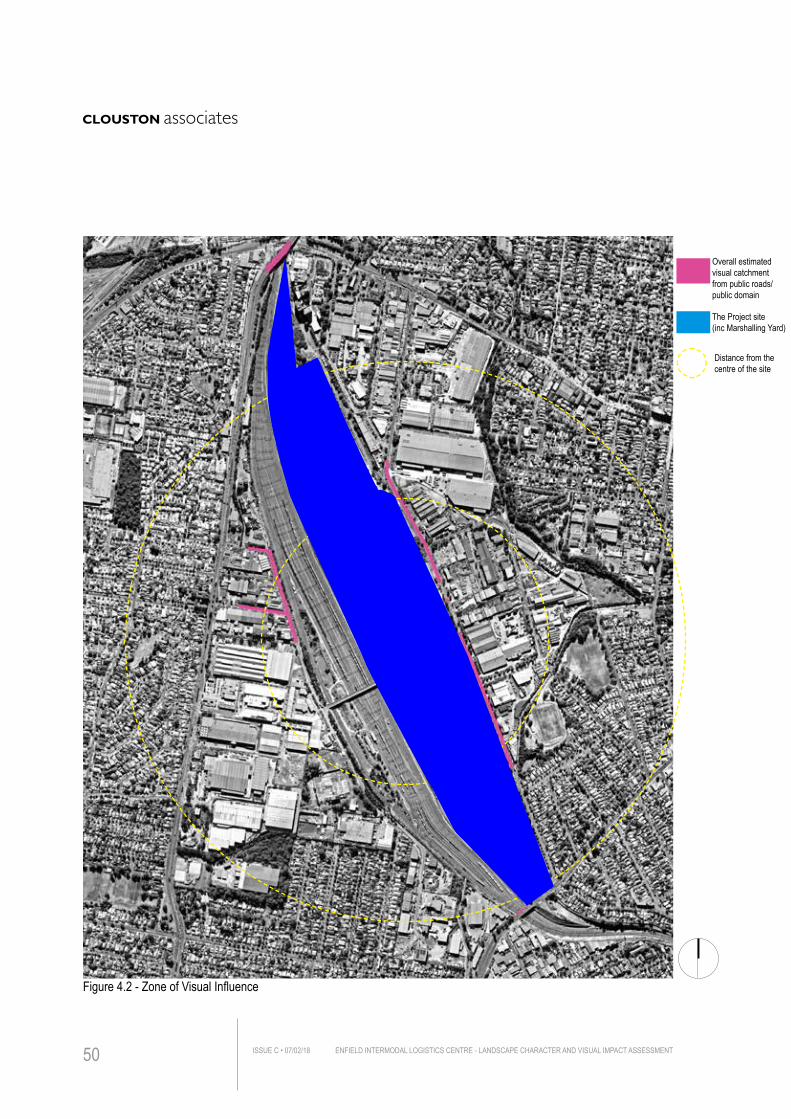
4.1.2 Zone of Visual InfluenceThe Zone of Visual Influence (ZVI), illustrated in Figure 4.2, illustrates the area of the landscape from which the viewer can see the impacts of the proposed works (Note that this broad zone has been established from the view of the visible horizon based on a site view and documented photographs).
This zone provides a framework and structure for the subsequent fieldwork including location of receptors.
4.2 REPRESENTATIVE VIEWPOINTSThe following representative viewpoints have been chosen for further analysis on the basis of a suite of nominated criteria and original visual assessment report. The visual receptors chosen at these viewpoints have the potential to be impacted by some part of the Project.
ENFIELD INTERMODAL LOGISTICS CENTRE - LANDSCAPE CHARACTER AND VISUAL IMPACT ASSESSMENT ISSUE C • 07/02/18 47
4. VISUAL IMPACT ASSESSMENT
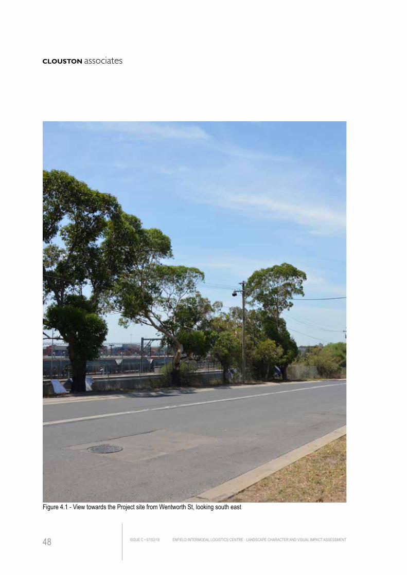
Figure 4.1 - View towards the Project site from Wentworth St, looking south east
ENFIELD INTERMODAL LOGISTICS CENTRE - LANDSCAPE CHARACTER AND VISUAL IMPACT ASSESSMENTISSUE C • 07/02/1848
Six of the views are similar or equivalent to the previous viewpoints that has been assessed in the original 2005 report. Since the Project site and its adjoining context hae been upgraded from time to time, the visual accessibility from those viewpoints has needed to be re-assessed.
It should be noted that this is not an exhaustive list of all viewpoints expected to be impacted by the Project but rather gives a representation of the key receptors and impacts across the Project site, from different distances and orientation.The locations identified are:
Public Viewpoints
1. Centenary Dr near Hume Hwy, looking south east3. Ford St near Wentworth St, looking east4. Entrance at Mainline Rd, looking east6. Bellfrog St, looking north7. Punchbowl Rd rail overpass, looking slightly north west8. Lookout at Southern Precinct, looking north 10. Begnell Sports Field, looking west11. Cosgrove Rd near Hope St, looking west12. Cosgrove Rd near Pilcher St, looking north west13. Cosgrove Rd near Gould St, looking south
Private Viewpoints
2. Jeans St near Roberts Rd, looking east5. Rawson Rd, looking east9. Blanche St, looking west
4.3 LIGHT SPILLSConsidering the built form of the warehouses will be higher but generally of similar nature form and operation, the lighting impacts are likely to be similar to these of the original assessment, which suggested that they would be of negligible visual impact.
ENFIELD INTERMODAL LOGISTICS CENTRE - LANDSCAPE CHARACTER AND VISUAL IMPACT ASSESSMENT ISSUE C • 07/02/18 49
500m
1000m
Figure 4.2 - Zone of Visual Influence
Overall estimated visual catchment from public roads/public domain
The Project site(inc Marshalling Yard)
Distance from the centre of the site
ENFIELD INTERMODAL LOGISTICS CENTRE - LANDSCAPE CHARACTER AND VISUAL IMPACT ASSESSMENTISSUE C • 07/02/1850
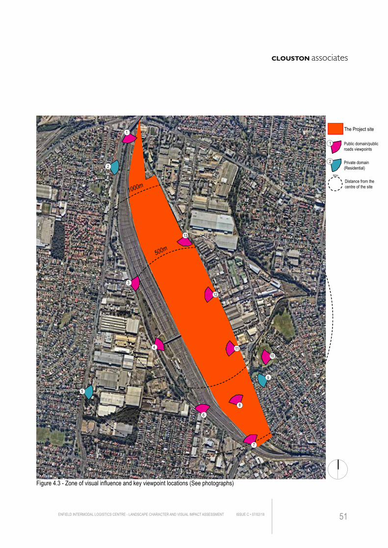
Figure 4.3 - Zone of visual influence and key viewpoint locations (See photographs)
9
2
5
500m
1000m
1
3
6
7
8
1011
12
13
4
1
2
Public domain/public roads viewpoints
Private domain (Residential)
The Project site
The Project site(inc Marshalling Yard)
Distance from the centre of the site
500m
ENFIELD INTERMODAL LOGISTICS CENTRE - LANDSCAPE CHARACTER AND VISUAL IMPACT ASSESSMENT ISSUE C • 07/02/18 51
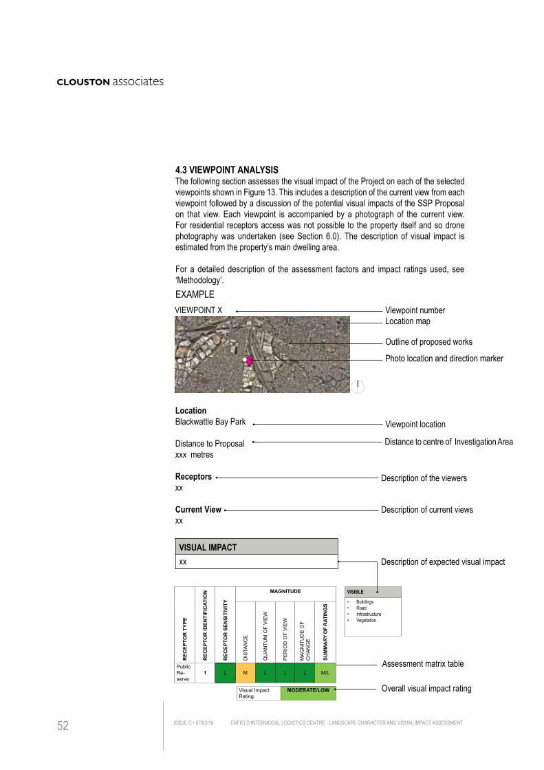
Location map
Outline of proposed works
Photo location and direction marker
Viewpoint location
Distance to centre of Investigation Area
Description of the viewers
Description of current views
Viewpoint number
4.3 VIEWPOINT ANALYSISThe following section assesses the visual impact of the Project on each of the selected viewpoints shown in Figure 13. This includes a description of the current view from each viewpoint followed by a discussion of the potential visual impacts of the SSP Proposal on that view. Each viewpoint is accompanied by a photograph of the current view. For residential receptors access was not possible to the property itself and so drone photography was undertaken (see Section 6.0). The description of visual impact is estimated from the property’s main dwelling area.
For a detailed description of the assessment factors and impact ratings used, see ‘Methodology’.
Assessment matrix table
Description of expected visual impact
VIEWPOINT X
LocationBlackwattle Bay Park
Distance to Proposalxxx metres
Receptorsxx
Current Viewxx
VISUAL IMPACTxx
REC
EPTO
R T
YPE
REC
EPTO
R ID
ENTI
FIC
ATIO
N
REC
EPTO
R S
ENSI
TIVI
TY
MAGNITUDE
DIS
TAN
CE
QU
AN
TUM
OF
VIE
W
PE
RIO
D O
F V
IEW
MA
GN
ITU
DE
OF
CH
AN
GE
SUM
MA
RY O
F R
ATIN
GS
Public Re-serve
1 L M L L L M/L
Visual Impact Rating
MODERATE/LOW
VISIBLE
• Buildings• Road• Infrastructure• Vegetation
EXAMPLE
Overall visual impact rating
ENFIELD INTERMODAL LOGISTICS CENTRE - LANDSCAPE CHARACTER AND VISUAL IMPACT ASSESSMENTISSUE C • 07/02/1852
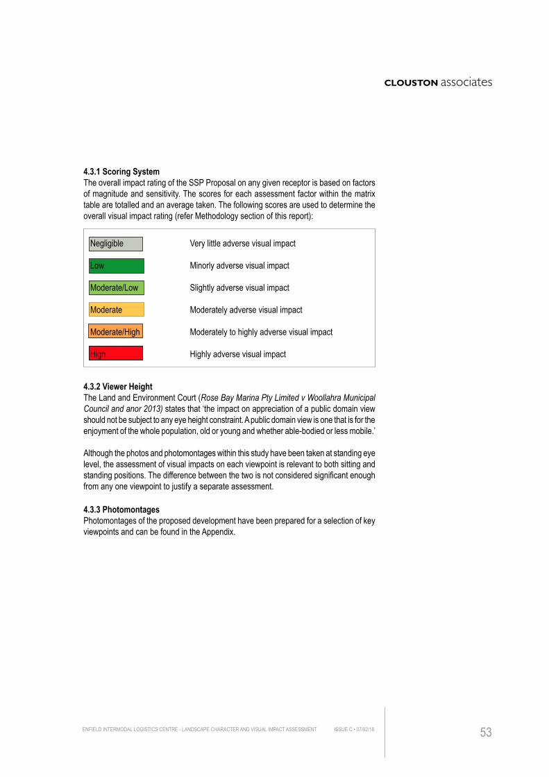
4.3.1 Scoring SystemThe overall impact rating of the SSP Proposal on any given receptor is based on factors of magnitude and sensitivity. The scores for each assessment factor within the matrix table are totalled and an average taken. The following scores are used to determine the overall visual impact rating (refer Methodology section of this report):
4.3.2 Viewer HeightThe Land and Environment Court (Rose Bay Marina Pty Limited v Woollahra Municipal Council and anor 2013) states that ‘the impact on appreciation of a public domain view should not be subject to any eye height constraint. A public domain view is one that is for the enjoyment of the whole population, old or young and whether able-bodied or less mobile.’
Although the photos and photomontages within this study have been taken at standing eye level, the assessment of visual impacts on each viewpoint is relevant to both sitting and standing positions. The difference between the two is not considered significant enough from any one viewpoint to justify a separate assessment.
4.3.3 Photomontages Photomontages of the proposed development have been prepared for a selection of key viewpoints and can be found in the Appendix.
Negligible Very little adverse visual impact
Low Minorly adverse visual impact
Moderate/Low Slightly adverse visual impact Moderate Moderately adverse visual impact
Moderate/High Moderately to highly adverse visual impact
High Highly adverse visual impact
ENFIELD INTERMODAL LOGISTICS CENTRE - LANDSCAPE CHARACTER AND VISUAL IMPACT ASSESSMENT ISSUE C • 07/02/18 53
IMPACT ASSESSMENT BEFORE MITIGATION
REC
EPTO
R T
YP
E
REC
EPTO
R ID
ENTI
FIC
ATIO
N
REC
EPTO
R S
ENS
ITIV
ITY
MAGNITUDE
DIS
TAN
CE
QU
AN
TUM
OF
VIEW
PER
IOD
OF
VIEW
SC
ALE
OF
CH
AN
GE
SU
MM
AR
Y O
F R
ATIN
GS
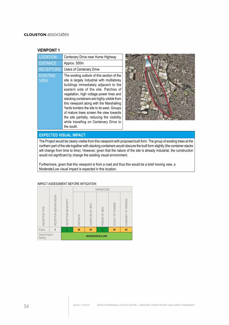
Public 1 L M M L M M
Visual Impact Rating
MODERATE/LOW
LOCATION Centenary Drive near Hume HighwayDISTANCE Approx. 500mRECEPTORS Users of Centenary DriveEXISTING VIEW
The existing outlook of this section of the site is largely industrial with multistorey buildings immediately adjacent to the eastern side of the site. Patches of vegetation, high voltage power lines and stacking containers are highly visible from this viewpoint along with the Marshalling Yards borders the site to its west. Groups of mature trees screen the view towards the site partially, reducing the visibility while travelling on Centenary Drive to the south.
EXPECTED VISUAL IMPACTThe Project would be clearly visible from this viewpoint with proposed built form. The group of existing trees at the northern part of the site together with stacking containers would obscure the built form slightly (the container stacks will change from time to time). However, given that the nature of the site is already industrial, the construction would not significant by change the existing visual environment.
Furthermore, given that this viewpoint is from a road and thus this would be a brief moving view, a Moderate/Low visual impact is expected in this location.
1
VIEWPOINT 1
ENFIELD INTERMODAL LOGISTICS CENTRE - LANDSCAPE CHARACTER AND VISUAL IMPACT ASSESSMENTISSUE C • 07/02/1854
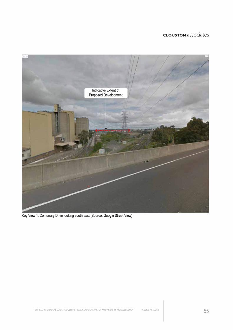
Key View 1: Centenary Drive looking south east (Source: Google Street View)
Indicative Extent of Proposed Development
ENFIELD INTERMODAL LOGISTICS CENTRE - LANDSCAPE CHARACTER AND VISUAL IMPACT ASSESSMENT ISSUE C • 07/02/18 55

IMPACT ASSESSMENT BEFORE MITIGATION
REC
EPTO
R T
YP
E
REC
EPTO
R ID
ENTI
FIC
ATIO
N
REC
EPTO
R S
ENS
ITIV
ITY
MAGNITUDE
DIS
TAN
CE
QU
AN
TUM
OF
VIEW
PER
IOD
OF
VIEW
SC
ALE
OF
CH
AN
GE
SU
MM
AR
Y O
F R
ATIN
GS
Public 2 M M L M N L
Visual Impact Rating
MODERATE/LOW
LOCATION Jeans Street near Roberts Road DISTANCE Approx. 330mRECEPTORS Residential dwellings off Jean Street usersEXISTING VIEW
The existing outlook from Jeans Street is residential in character with single dwelling properties lining the street. The foreground is dominated by dense vegetation and a retaining wall, which significantly reduces the visibility of the Project site from this viewpoint.
EXPECTED VISUAL IMPACTFrom this viewpoint, the proposed built form and other construction would be largely obscured by a significant number of mature trees with overlapping canopies along Roberts Road. However, proposed construction could be seen filtered through tree branches and thus a Moderate/Low rating is assessed for this view.
2
VIEWPOINT 2
ENFIELD INTERMODAL LOGISTICS CENTRE - LANDSCAPE CHARACTER AND VISUAL IMPACT ASSESSMENTISSUE C • 07/02/1856
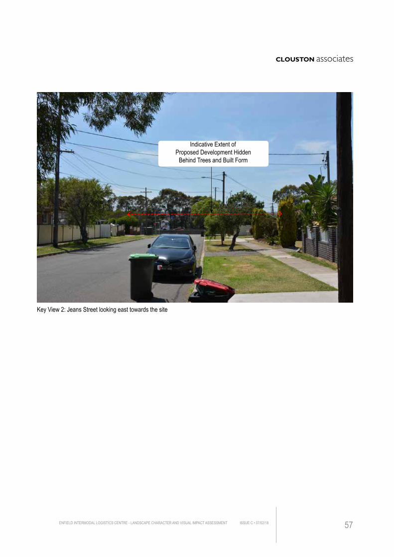
Key View 2: Jeans Street looking east towards the site
Indicative Extent of Proposed Development Hidden
Behind Trees and Built Form
ENFIELD INTERMODAL LOGISTICS CENTRE - LANDSCAPE CHARACTER AND VISUAL IMPACT ASSESSMENT ISSUE C • 07/02/18 57
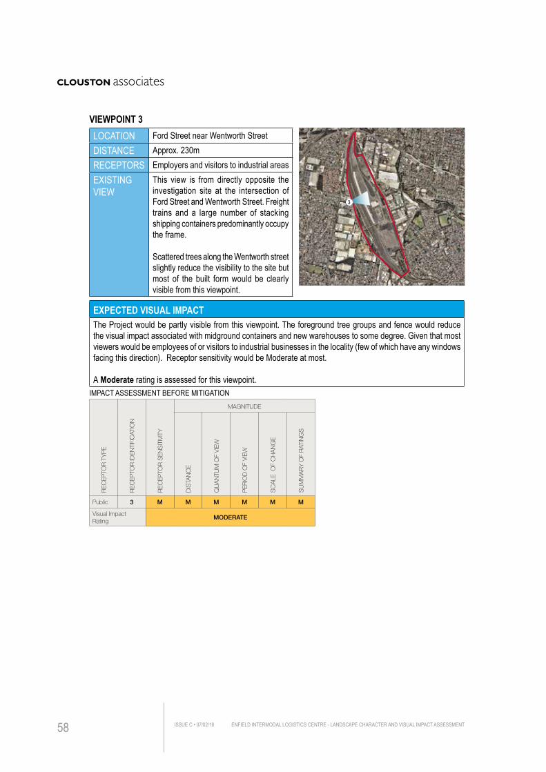
LOCATION Ford Street near Wentworth Street DISTANCE Approx. 230mRECEPTORS Employers and visitors to industrial areasEXISTING VIEW
This view is from directly opposite the investigation site at the intersection of Ford Street and Wentworth Street. Freight trains and a large number of stacking shipping containers predominantly occupy the frame.
Scattered trees along the Wentworth street slightly reduce the visibility to the site but most of the built form would be clearly visible from this viewpoint.
EXPECTED VISUAL IMPACTThe Project would be partly visible from this viewpoint. The foreground tree groups and fence would reduce the visual impact associated with midground containers and new warehouses to some degree. Given that most viewers would be employees of or visitors to industrial businesses in the locality (few of which have any windows facing this direction). Receptor sensitivity would be Moderate at most.
A Moderate rating is assessed for this viewpoint. IMPACT ASSESSMENT BEFORE MITIGATION
REC
EPTO
R T
YP
E
REC
EPTO
R ID
ENTI
FIC
ATIO
N
REC
EPTO
R S
ENS
ITIV
ITY
MAGNITUDE
DIS
TAN
CE
QU
AN
TUM
OF
VIEW
PER
IOD
OF
VIEW
SC
ALE
OF
CH
AN
GE
SU
MM
AR
Y O
F R
ATIN
GS
Public 3 M M M M M M
Visual Impact Rating
MODERATE
3
VIEWPOINT 3
ENFIELD INTERMODAL LOGISTICS CENTRE - LANDSCAPE CHARACTER AND VISUAL IMPACT ASSESSMENTISSUE C • 07/02/1858
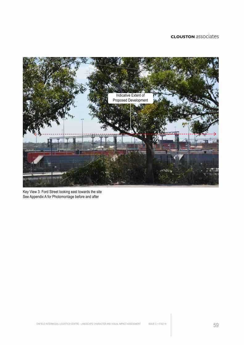
Key View 3: Ford Street looking east towards the site See Appendix A for Photomontage before and after
Indicative Extent of Proposed Development
ENFIELD INTERMODAL LOGISTICS CENTRE - LANDSCAPE CHARACTER AND VISUAL IMPACT ASSESSMENT ISSUE C • 07/02/18 59
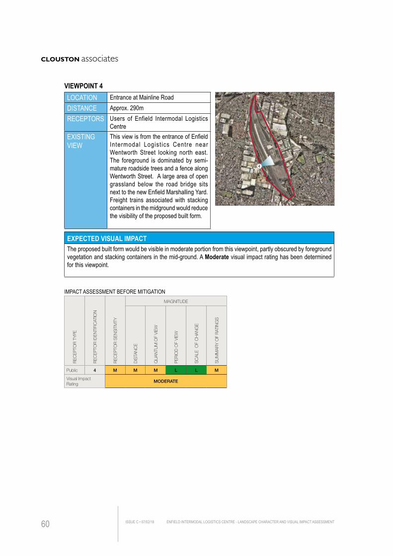
LOCATION Entrance at Mainline RoadDISTANCE Approx. 290mRECEPTORS Users of Enfield Intermodal Logistics
CentreEXISTING VIEW
This view is from the entrance of Enfield Intermodal Logist ics Centre near Wentworth Street looking north east. The foreground is dominated by semi-mature roadside trees and a fence along Wentworth Street. A large area of open grassland below the road bridge sits next to the new Enfield Marshalling Yard. Freight trains associated with stacking containers in the midground would reduce the visibility of the proposed built form.
EXPECTED VISUAL IMPACTThe proposed built form would be visible in moderate portion from this viewpoint, partly obscured by foreground vegetation and stacking containers in the mid-ground. A Moderate visual impact rating has been determined for this viewpoint.
IMPACT ASSESSMENT BEFORE MITIGATION
REC
EPTO
R T
YP
E
REC
EPTO
R ID
ENTI
FIC
ATIO
N
REC
EPTO
R S
ENS
ITIV
ITY
MAGNITUDE
DIS
TAN
CE
QU
AN
TUM
OF
VIEW
PER
IOD
OF
VIEW
SC
ALE
OF
CH
AN
GE
SU
MM
AR
Y O
F R
ATIN
GS
Public 4 M M M L L M
Visual Impact Rating
MODERATE
4
VIEWPOINT 4
ENFIELD INTERMODAL LOGISTICS CENTRE - LANDSCAPE CHARACTER AND VISUAL IMPACT ASSESSMENTISSUE C • 07/02/1860
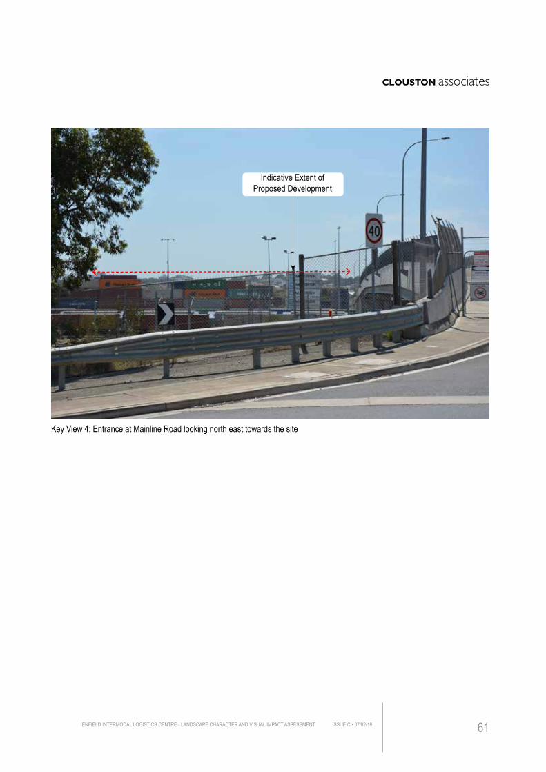
Key View 4: Entrance at Mainline Road looking north east towards the site
Indicative Extent of Proposed Development
ENFIELD INTERMODAL LOGISTICS CENTRE - LANDSCAPE CHARACTER AND VISUAL IMPACT ASSESSMENT ISSUE C • 07/02/18 61
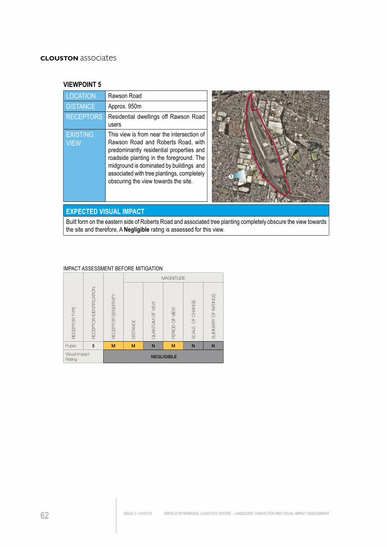
LOCATION Rawson RoadDISTANCE Approx. 950mRECEPTORS Residential dwellings off Rawson Road
usersEXISTING VIEW
This view is from near the intersection of Rawson Road and Roberts Road, with predominantly residential properties and roadside planting in the foreground. The midground is dominated by buildings and associated with tree plantings, completely obscuring the view towards the site.
EXPECTED VISUAL IMPACTBuilt form on the eastern side of Roberts Road and associated tree planting completely obscure the view towards the site and therefore, A Negligible rating is assessed for this view.
IMPACT ASSESSMENT BEFORE MITIGATION
REC
EPTO
R T
YP
E
REC
EPTO
R ID
ENTI
FIC
ATIO
N
REC
EPTO
R S
ENS
ITIV
ITY
MAGNITUDE
DIS
TAN
CE
QU
AN
TUM
OF
VIEW
PER
IOD
OF
VIEW
SC
ALE
OF
CH
AN
GE
SU
MM
AR
Y O
F R
ATIN
GS
Public 5 M M N M N N
Visual Impact Rating
NEGLIGIBLE
5
VIEWPOINT 5
ENFIELD INTERMODAL LOGISTICS CENTRE - LANDSCAPE CHARACTER AND VISUAL IMPACT ASSESSMENTISSUE C • 07/02/1862
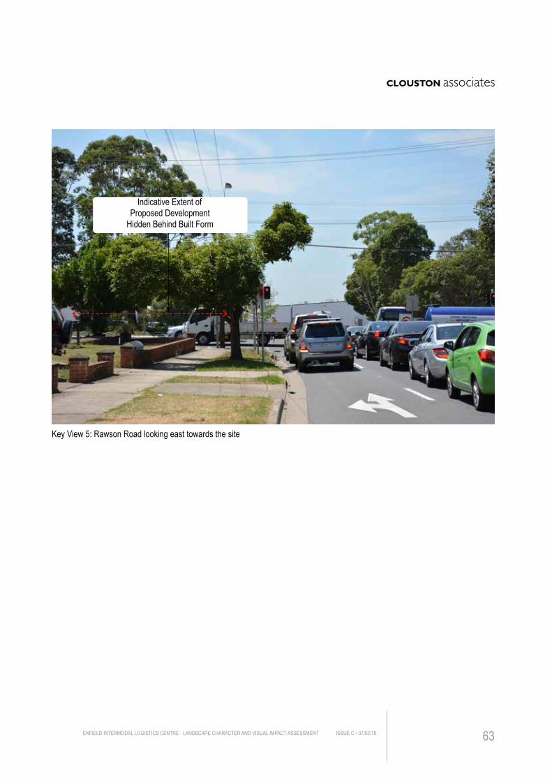
Key View 5: Rawson Road looking east towards the site
Indicative Extent of Proposed Development
Hidden Behind Built Form
ENFIELD INTERMODAL LOGISTICS CENTRE - LANDSCAPE CHARACTER AND VISUAL IMPACT ASSESSMENT ISSUE C • 07/02/18 63

LOCATION Bellfrog Street DISTANCE Approx. 280mRECEPTORS Users of Bellfrog Street, residents nearbyEXISTING VIEW
The view is taken from Bellfrog Street looking north east. A noise wall and residential properties with a fence are positioned in the foreground and midground. Dense tree planting along the eastern side of Wentworth Street is clearly visible in the background.
EXPECTED VISUAL IMPACTNo built form would be visible from this viewpoint because of the noise wall running along the eastern side of Bellfrog Street. A Negligible rating has been determined for this viewpoint.
IMPACT ASSESSMENT BEFORE MITIGATION
REC
EPTO
R T
YP
E
REC
EPTO
R ID
ENTI
FIC
ATIO
N
REC
EPTO
R S
ENS
ITIV
ITY
MAGNITUDE
DIS
TAN
CE
QU
AN
TUM
OF
VIEW
PER
IOD
OF
VIEW
SC
ALE
OF
CH
AN
GE
SU
MM
AR
Y O
F R
ATIN
GS
Public 6 M M N M N N
Visual Impact Rating
NEGLIGIBLE
6
VIEWPOINT 6
ENFIELD INTERMODAL LOGISTICS CENTRE - LANDSCAPE CHARACTER AND VISUAL IMPACT ASSESSMENTISSUE C • 07/02/1864
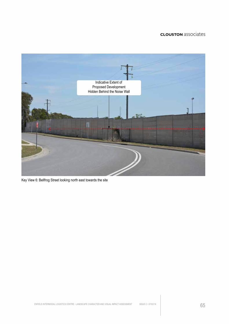
Key View 6: Bellfrog Street looking north east towards the site
Indicative Extent of Proposed Development
Hidden Behind the Noise Wall
ENFIELD INTERMODAL LOGISTICS CENTRE - LANDSCAPE CHARACTER AND VISUAL IMPACT ASSESSMENT ISSUE C • 07/02/18 65
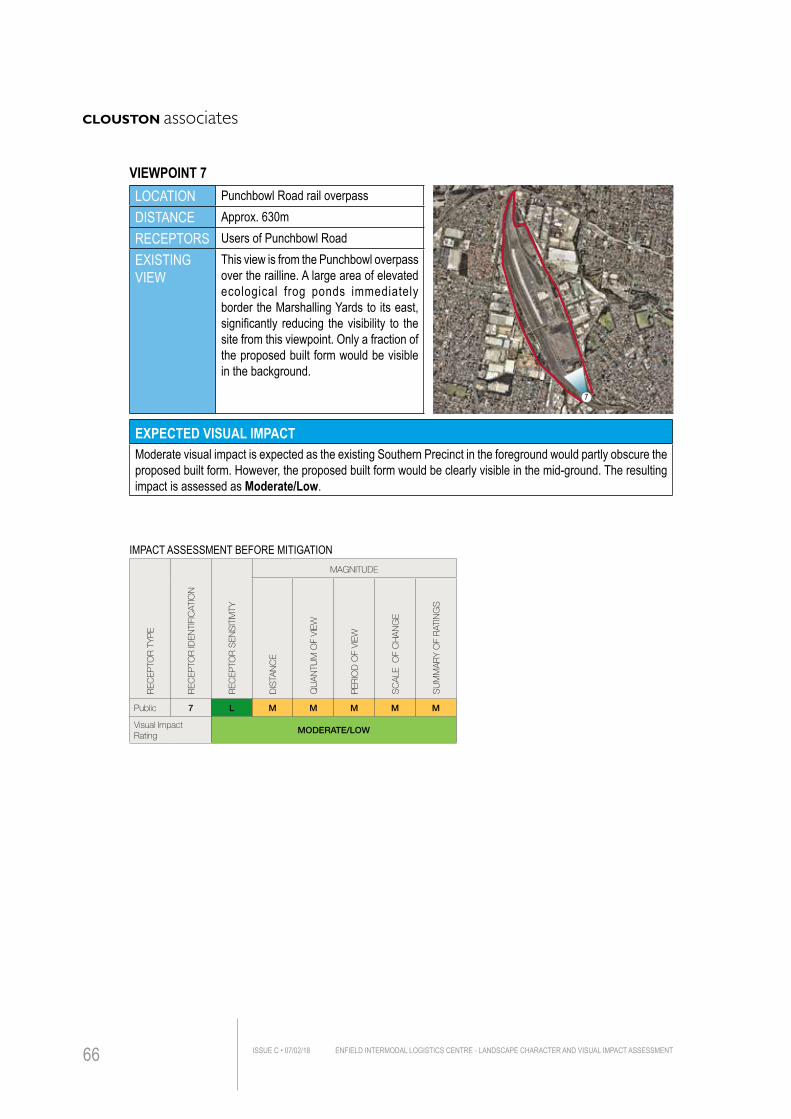
LOCATION Punchbowl Road rail overpassDISTANCE Approx. 630mRECEPTORS Users of Punchbowl RoadEXISTING VIEW
This view is from the Punchbowl overpass over the railline. A large area of elevated ecological frog ponds immediately border the Marshalling Yards to its east, significantly reducing the visibility to the site from this viewpoint. Only a fraction of the proposed built form would be visible in the background.
EXPECTED VISUAL IMPACTModerate visual impact is expected as the existing Southern Precinct in the foreground would partly obscure the proposed built form. However, the proposed built form would be clearly visible in the mid-ground. The resulting impact is assessed as Moderate/Low.
IMPACT ASSESSMENT BEFORE MITIGATION
REC
EPTO
R T
YP
E
REC
EPTO
R ID
ENTI
FIC
ATIO
N
REC
EPTO
R S
ENS
ITIV
ITY
MAGNITUDE
DIS
TAN
CE
QU
AN
TUM
OF
VIEW
PER
IOD
OF
VIEW
SC
ALE
OF
CH
AN
GE
SU
MM
AR
Y O
F R
ATIN
GS
Public 7 L M M M M M
Visual Impact Rating
MODERATE/LOW
7
VIEWPOINT 7
ENFIELD INTERMODAL LOGISTICS CENTRE - LANDSCAPE CHARACTER AND VISUAL IMPACT ASSESSMENTISSUE C • 07/02/1866
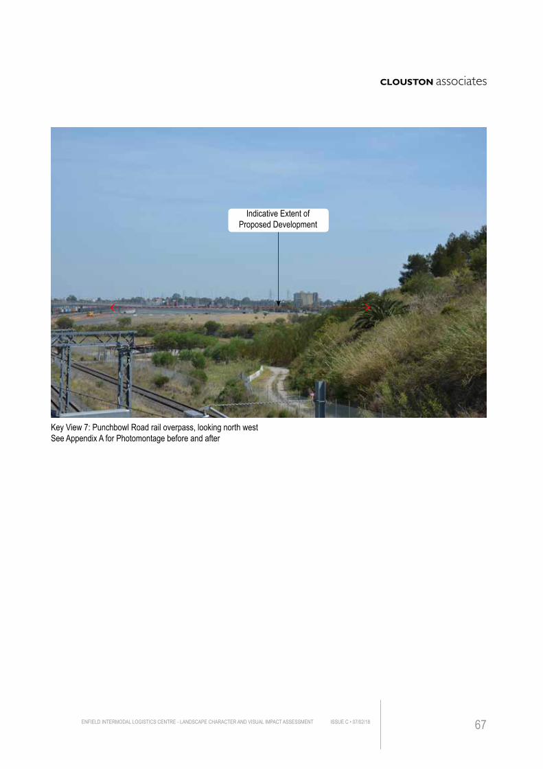
Key View 7: Punchbowl Road rail overpass, looking north westSee Appendix A for Photomontage before and after
Indicative Extent of Proposed Development
ENFIELD INTERMODAL LOGISTICS CENTRE - LANDSCAPE CHARACTER AND VISUAL IMPACT ASSESSMENT ISSUE C • 07/02/18 67
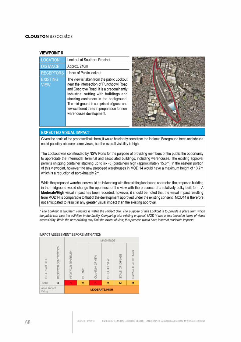
LOCATION Lookout at Southern PrecinctDISTANCE Approx. 240mRECEPTORS Users of Public lookoutEXISTING VIEW
The view is taken from the public Lookout near the intersection of Punchbowl Road and Cosgrove Road. It is a predominantly industrial setting with buildings and stacking containers in the background. The mid-ground is comprised of grass and few scattered trees in preparation for new warehouses development.
EXPECTED VISUAL IMPACTGiven the scale of the proposed built form, it would be clearly seen from the lookout. Foreground trees and shrubs could possibly obscure some views, but the overall visibility is high.
The Lookout was constructed by NSW Ports for the purpose of providing members of the public the opportunity to appreciate the Intermodal Terminal and associated buildings, including warehouses. The existing approval permits shipping container stacking up to six (6) containers high (approximately 15.6m) in the eastern portion of this viewpoint, however the new proposed warehouses in MOD 14 would have a maximum height of 13.7m which is a reduction of aproximately 2m.
While the proposed warehouses would be in keeping with the existing landscape character, the proposed building in the midground would change the openness of the view with the presence of a relatively bulky built form. A Moderate/High visual impact has been recorded, however, it should be noted that the visual impact resulting from MOD14 is comparable to that of the development approved under the existing consent. MOD14 is therefore not anticipated to result in any greater visual impact than the existing approval.
IMPACT ASSESSMENT BEFORE MITIGATION
REC
EPTO
R T
YP
E
REC
EPTO
R ID
ENTI
FIC
ATIO
N
REC
EPTO
R S
ENS
ITIV
ITY
MAGNITUDE
DIS
TAN
CE
QU
AN
TUM
OF
VIEW
PER
IOD
OF
VIEW
SC
ALE
OF
CH
AN
GE
SU
MM
AR
Y O
F R
ATIN
GS
Public 8 H M H M M M
Visual Impact Rating
MODERATE/HIGH
8
VIEWPOINT 8
* The Lookout at Southern Precinct is within the Project Site. The purpose of this Lookout is to provide a place from which the public can view the activities in the facility. Comparing with existing proposal, MOD14 has a less impact in terms of visual accessibility. While the new building may limit the extent of view, this purpose would have inherent moderate impacts.
ENFIELD INTERMODAL LOGISTICS CENTRE - LANDSCAPE CHARACTER AND VISUAL IMPACT ASSESSMENTISSUE C • 07/02/1868
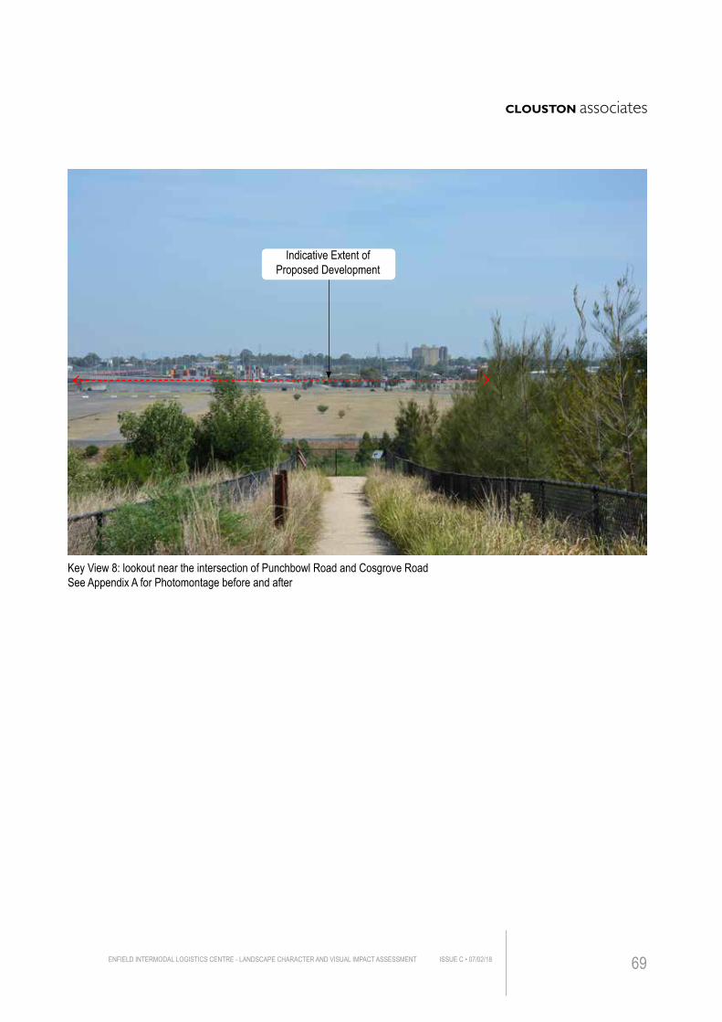
Key View 8: lookout near the intersection of Punchbowl Road and Cosgrove RoadSee Appendix A for Photomontage before and after
Indicative Extent of Proposed Development
ENFIELD INTERMODAL LOGISTICS CENTRE - LANDSCAPE CHARACTER AND VISUAL IMPACT ASSESSMENT ISSUE C • 07/02/18 69
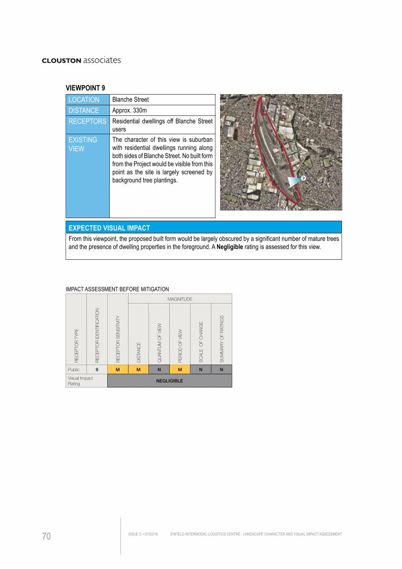
LOCATION Blanche StreetDISTANCE Approx. 330mRECEPTORS Residential dwellings off Blanche Street
usersEXISTING VIEW
The character of this view is suburban with residential dwellings running along both sides of Blanche Street. No built form from the Project would be visible from this point as the site is largely screened by background tree plantings.
EXPECTED VISUAL IMPACTFrom this viewpoint, the proposed built form would be largely obscured by a significant number of mature trees and the presence of dwelling properties in the foreground. A Negligible rating is assessed for this view.
IMPACT ASSESSMENT BEFORE MITIGATION
REC
EPTO
R T
YP
E
REC
EPTO
R ID
ENTI
FIC
ATIO
N
REC
EPTO
R S
ENS
ITIV
ITY
MAGNITUDE
DIS
TAN
CE
QU
AN
TUM
OF
VIEW
PER
IOD
OF
VIEW
SC
ALE
OF
CH
AN
GE
SU
MM
AR
Y O
F R
ATIN
GS
Public 9 M M N M N N
Visual Impact Rating
NEGLIGIBLE
9
VIEWPOINT 9
ENFIELD INTERMODAL LOGISTICS CENTRE - LANDSCAPE CHARACTER AND VISUAL IMPACT ASSESSMENTISSUE C • 07/02/1870
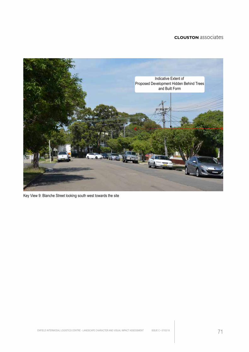
Key View 9: Blanche Street looking south west towards the site
Indicative Extent of Proposed Development Hidden Behind Trees
and Built Form
ENFIELD INTERMODAL LOGISTICS CENTRE - LANDSCAPE CHARACTER AND VISUAL IMPACT ASSESSMENT ISSUE C • 07/02/18 71
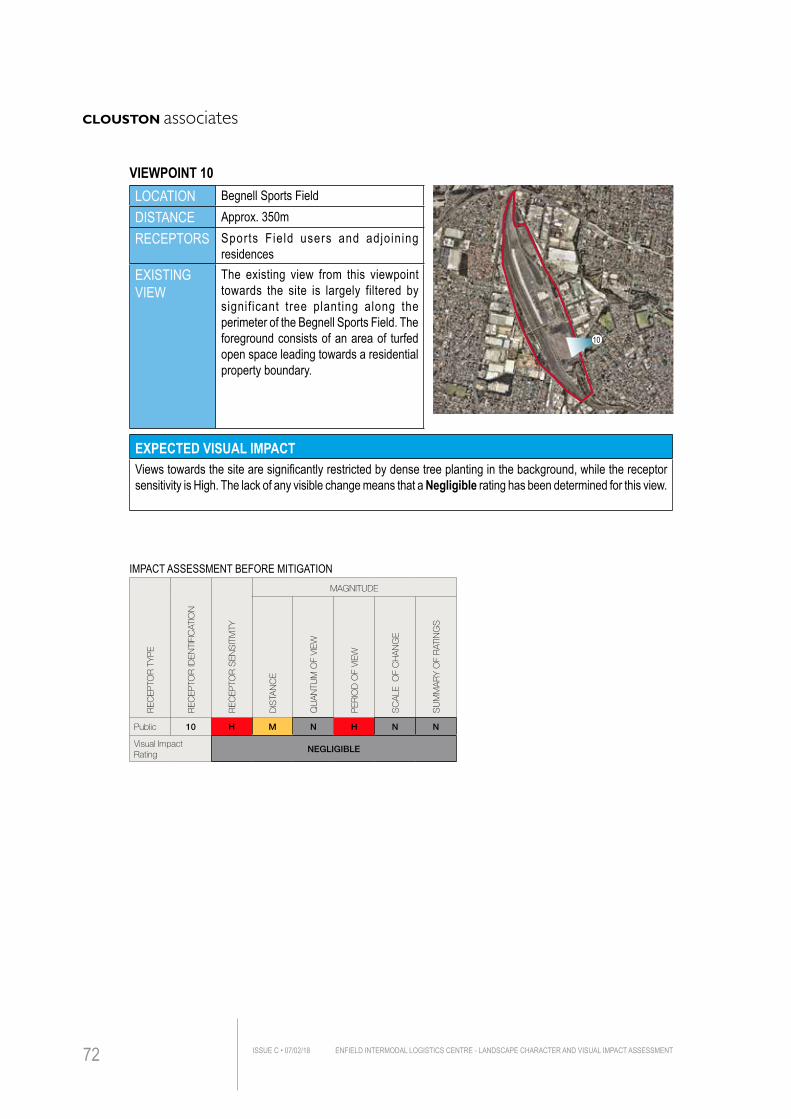
LOCATION Begnell Sports FieldDISTANCE Approx. 350mRECEPTORS Sports Field users and adjoining
residencesEXISTING VIEW
The existing view from this viewpoint towards the site is largely filtered by signif icant tree planting along the perimeter of the Begnell Sports Field. The foreground consists of an area of turfed open space leading towards a residential property boundary.
EXPECTED VISUAL IMPACTViews towards the site are significantly restricted by dense tree planting in the background, while the receptor sensitivity is High. The lack of any visible change means that a Negligible rating has been determined for this view.
IMPACT ASSESSMENT BEFORE MITIGATION
REC
EPTO
R T
YP
E
REC
EPTO
R ID
ENTI
FIC
ATIO
N
REC
EPTO
R S
ENS
ITIV
ITY
MAGNITUDE
DIS
TAN
CE
QU
AN
TUM
OF
VIEW
PER
IOD
OF
VIEW
SC
ALE
OF
CH
AN
GE
SU
MM
AR
Y O
F R
ATIN
GS
Public 10 H M N H N N
Visual Impact Rating
NEGLIGIBLE
10
VIEWPOINT 10
ENFIELD INTERMODAL LOGISTICS CENTRE - LANDSCAPE CHARACTER AND VISUAL IMPACT ASSESSMENTISSUE C • 07/02/1872
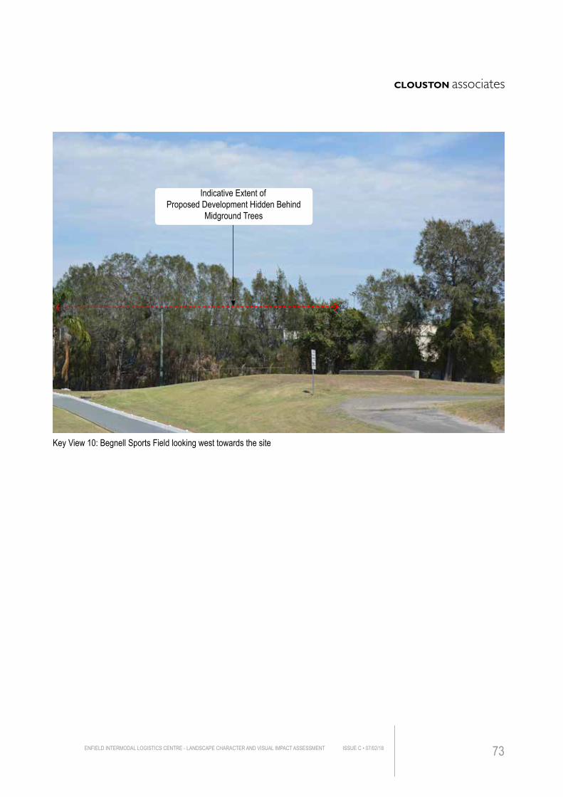
Key View 10: Begnell Sports Field looking west towards the site
Indicative Extent of Proposed Development Hidden Behind
Midground Trees
ENFIELD INTERMODAL LOGISTICS CENTRE - LANDSCAPE CHARACTER AND VISUAL IMPACT ASSESSMENT ISSUE C • 07/02/18 73
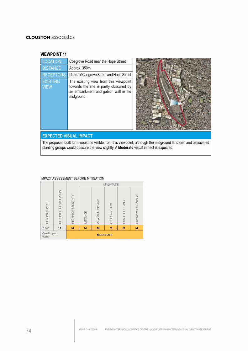
LOCATION Cosgrove Road near the Hope StreetDISTANCE Approx. 350mRECEPTORS Users of Cosgrove Street and Hope StreetEXISTING VIEW
The existing view from this viewpoint towards the site is partly obscured by an embankment and gabion wall in the midground.
EXPECTED VISUAL IMPACTThe proposed built form would be visible from this viewpoint, although the midground landform and associated planting groups would obscure the view slightly. A Moderate visual impact is expected.
IMPACT ASSESSMENT BEFORE MITIGATION
REC
EPTO
R T
YP
E
REC
EPTO
R ID
ENTI
FIC
ATIO
N
REC
EPTO
R S
ENS
ITIV
ITY
MAGNITUDE
DIS
TAN
CE
QU
AN
TUM
OF
VIEW
PER
IOD
OF
VIEW
SC
ALE
OF
CH
AN
GE
SU
MM
AR
Y O
F R
ATIN
GS
Public 11 M M M M M M
Visual Impact Rating
MODERATE
11
VIEWPOINT 11VIEWPOINT
ENFIELD INTERMODAL LOGISTICS CENTRE - LANDSCAPE CHARACTER AND VISUAL IMPACT ASSESSMENTISSUE C • 07/02/1874
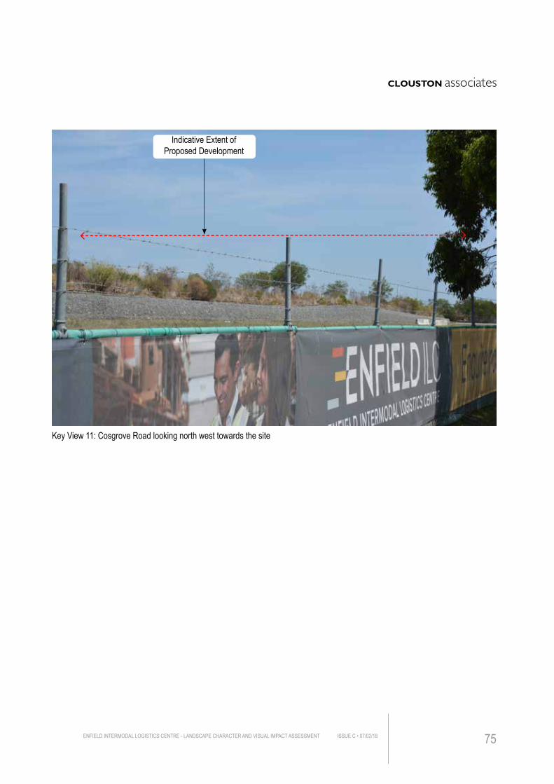
Key View 11: Cosgrove Road looking north west towards the site
Indicative Extent of Proposed Development
ENFIELD INTERMODAL LOGISTICS CENTRE - LANDSCAPE CHARACTER AND VISUAL IMPACT ASSESSMENT ISSUE C • 07/02/18 75
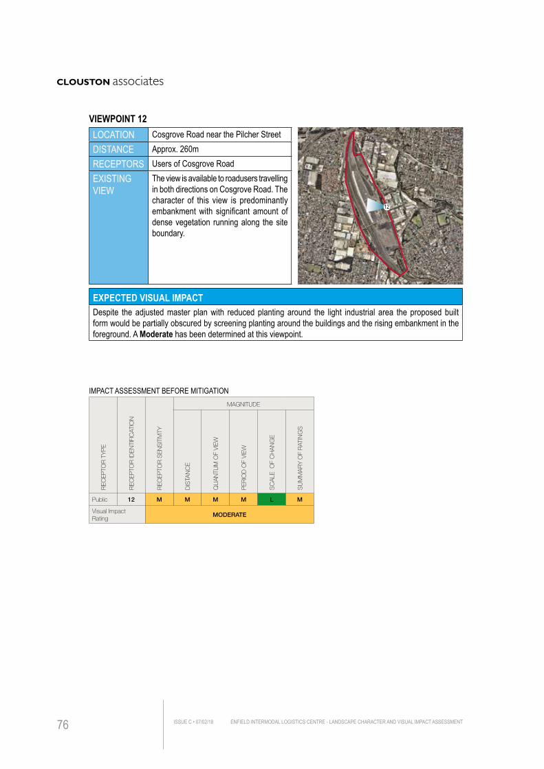
LOCATION Cosgrove Road near the Pilcher StreetDISTANCE Approx. 260mRECEPTORS Users of Cosgrove RoadEXISTING VIEW
The view is available to roadusers travelling in both directions on Cosgrove Road. The character of this view is predominantly embankment with significant amount of dense vegetation running along the site boundary.
EXPECTED VISUAL IMPACTDespite the adjusted master plan with reduced planting around the light industrial area the proposed built form would be partially obscured by screening planting around the buildings and the rising embankment in the foreground. A Moderate has been determined at this viewpoint.
IMPACT ASSESSMENT BEFORE MITIGATION
REC
EPTO
R T
YP
E
REC
EPTO
R ID
ENTI
FIC
ATIO
N
REC
EPTO
R S
ENS
ITIV
ITY
MAGNITUDE
DIS
TAN
CE
QU
AN
TUM
OF
VIEW
PER
IOD
OF
VIEW
SC
ALE
OF
CH
AN
GE
SU
MM
AR
Y O
F R
ATIN
GS
Public 12 M M M M L M
Visual Impact Rating
MODERATE
12
VIEWPOINT 12
ENFIELD INTERMODAL LOGISTICS CENTRE - LANDSCAPE CHARACTER AND VISUAL IMPACT ASSESSMENTISSUE C • 07/02/1876
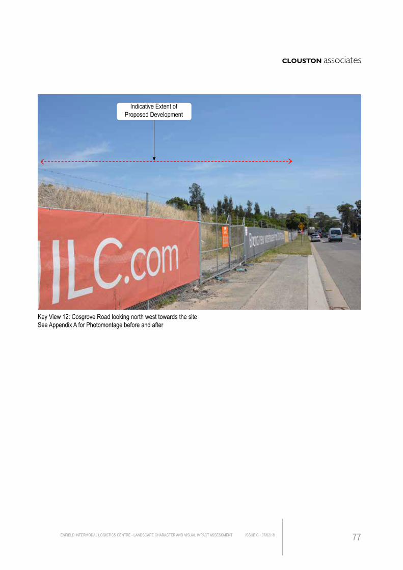
Key View 12: Cosgrove Road looking north west towards the site See Appendix A for Photomontage before and after
Indicative Extent of Proposed Development
ENFIELD INTERMODAL LOGISTICS CENTRE - LANDSCAPE CHARACTER AND VISUAL IMPACT ASSESSMENT ISSUE C • 07/02/18 77
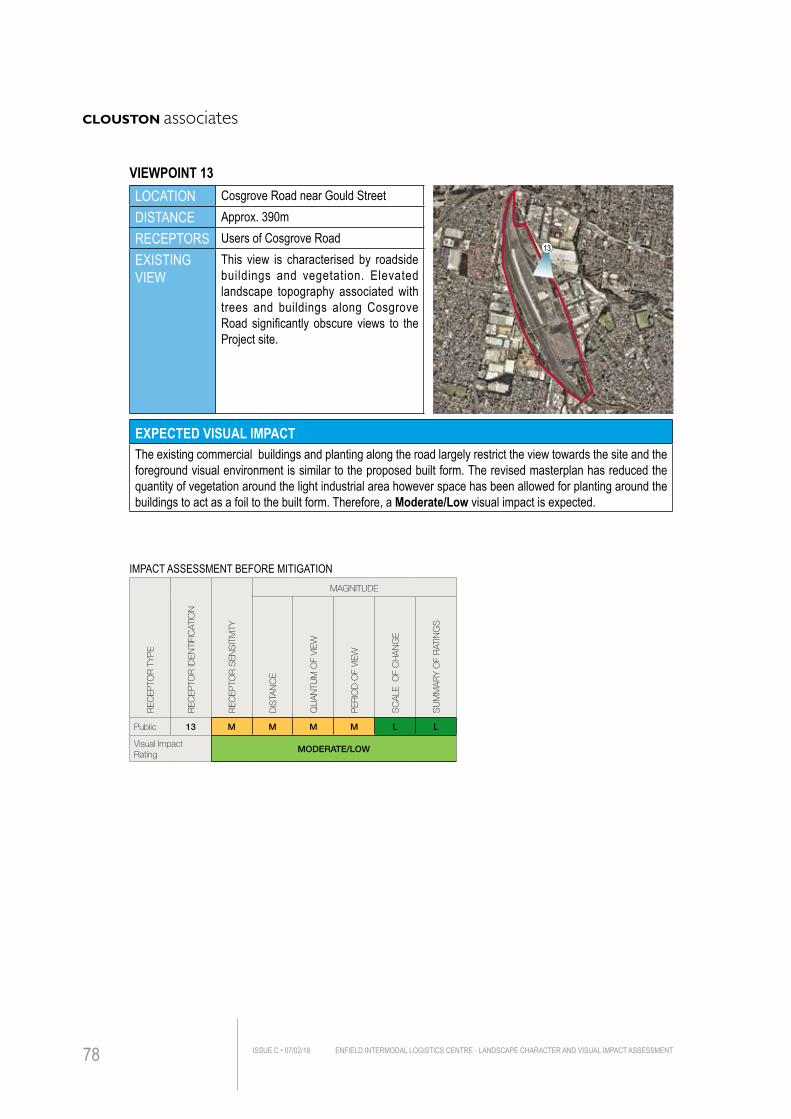
LOCATION Cosgrove Road near Gould StreetDISTANCE Approx. 390mRECEPTORS Users of Cosgrove RoadEXISTING VIEW
This view is characterised by roadside buildings and vegetation. Elevated landscape topography associated with trees and buildings along Cosgrove Road significantly obscure views to the Project site.
EXPECTED VISUAL IMPACTThe existing commercial buildings and planting along the road largely restrict the view towards the site and the foreground visual environment is similar to the proposed built form. The revised masterplan has reduced the quantity of vegetation around the light industrial area however space has been allowed for planting around the buildings to act as a foil to the built form. Therefore, a Moderate/Low visual impact is expected.
IMPACT ASSESSMENT BEFORE MITIGATION
REC
EPTO
R T
YP
E
REC
EPTO
R ID
ENTI
FIC
ATIO
N
REC
EPTO
R S
ENS
ITIV
ITY
MAGNITUDE
DIS
TAN
CE
QU
AN
TUM
OF
VIEW
PER
IOD
OF
VIEW
SC
ALE
OF
CH
AN
GE
SU
MM
AR
Y O
F R
ATIN
GS
Public 13 M M M M L L
Visual Impact Rating
MODERATE/LOW
13
VIEWPOINT 13
ENFIELD INTERMODAL LOGISTICS CENTRE - LANDSCAPE CHARACTER AND VISUAL IMPACT ASSESSMENTISSUE C • 07/02/1878
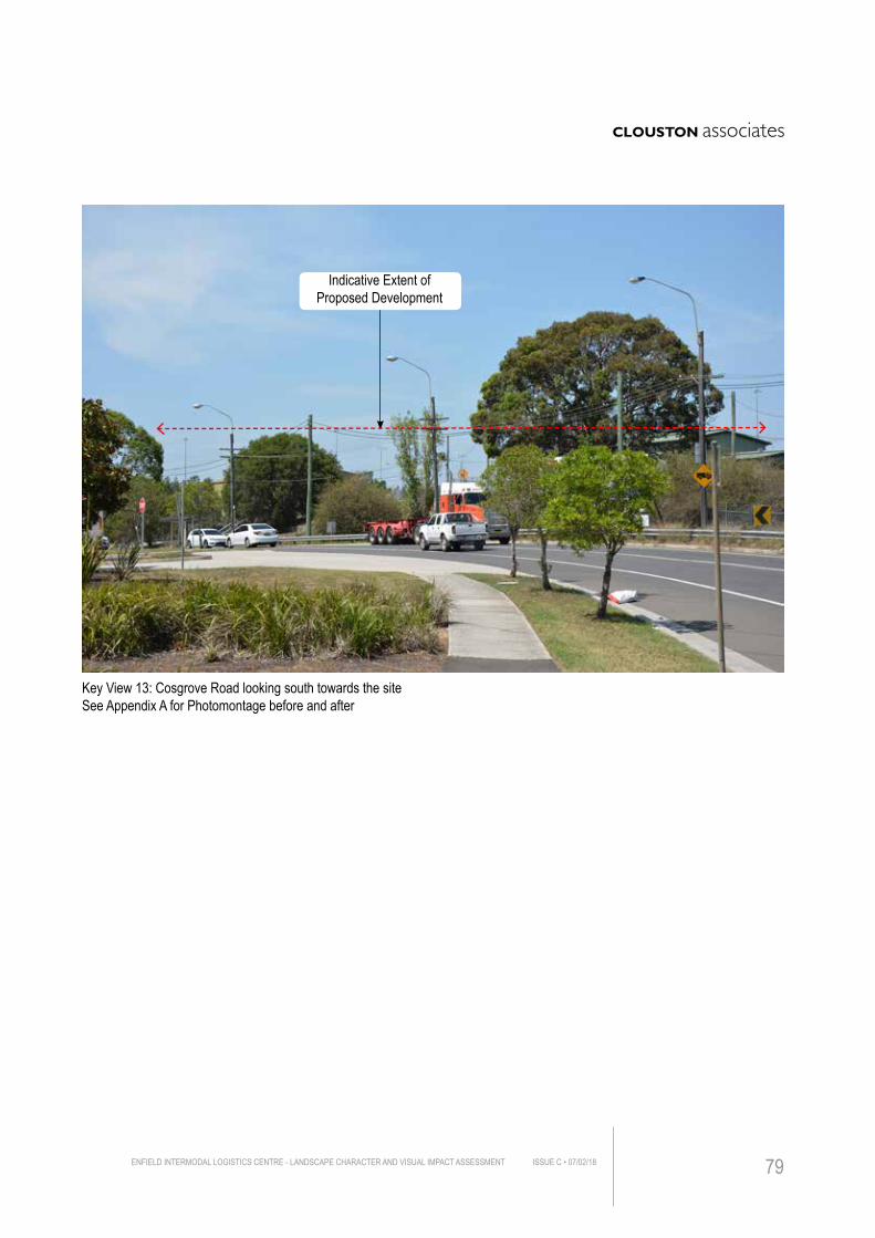
Key View 13: Cosgrove Road looking south towards the site See Appendix A for Photomontage before and after
Indicative Extent of Proposed Development
ENFIELD INTERMODAL LOGISTICS CENTRE - LANDSCAPE CHARACTER AND VISUAL IMPACT ASSESSMENT ISSUE C • 07/02/18 79
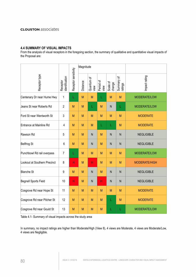
Table 4.1- Summary of visual impacts across the study area
4.4 SUMMARY OF VISUAL IMPACTSFrom the analysis of visual receptors in the foregoing section, the summary of qualitative and quantitative visual impacts of the Proposal are:
In summary, no impact ratings are higher than Moderate/High (View 8), 4 views are Moderate, 4 views are Moderate/Low, 4 views are Negligible.
Rece
ptor t
ype
Rece
ptor
identi
ficati
on
Rece
ptor s
ensit
ivity Magnitude
Dista
nce
Quan
tum of
vie
wPe
riod o
f vie
wSc
ale of
ch
ange
Summ
ary o
f ra
tings
Impa
ct ra
ting
Centenary Dr near Hume Hwy 1 L M M L M M MODERATE/LOW
Jeans St near Roberts Rd 2 M M L M N L MODERATE/LOW
Ford St near Wentworth St 3 M M M M M M MODERATE
Entrance at Mainline Rd 4 M M M L L M MODERATE
Rawson Rd 5 M M N M N N NEGLIGIBLE
Bellfrog St 6 M M N M N N NEGLIGIBLE
Punchbowl Rd rail overpass 7 L M M M M M MODERATE/LOW
Lookout at Southern Precinct 8 H M H M M M MODERATE/HIGH
Blanche St 9 M M N M N N NEGLIGIBLE
Begnell Sports Field 10 H M N H N N NEGLIGIBLE
Cosgrove Rd near Hope St 11 M M M M M M MODERATE
Cosgrove Rd near Pilcher St 12 M M M M L M MODERATE
Cosgrove Rd near Gould St 13 M M M M L L MODERATE/LOW
ENFIELD INTERMODAL LOGISTICS CENTRE - LANDSCAPE CHARACTER AND VISUAL IMPACT ASSESSMENTISSUE C • 07/02/1880
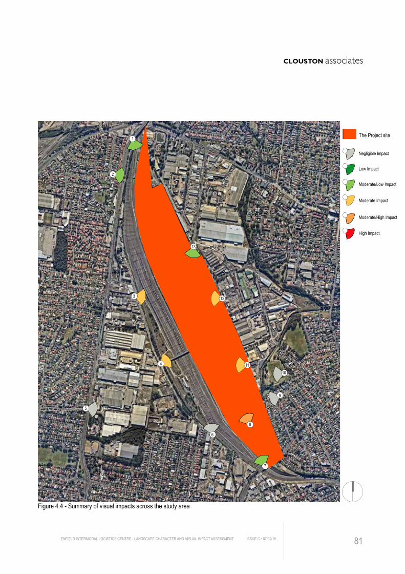
Figure 4.4 - Summary of visual impacts across the study area
9
2
5
3
6
7
8
1011
12
13
4
Negligible Impact
Moderate/Low Impact
Moderate/High Impact
Low Impact
Moderate Impact
High Impact
The Project site1
ENFIELD INTERMODAL LOGISTICS CENTRE - LANDSCAPE CHARACTER AND VISUAL IMPACT ASSESSMENT ISSUE C • 07/02/18 81
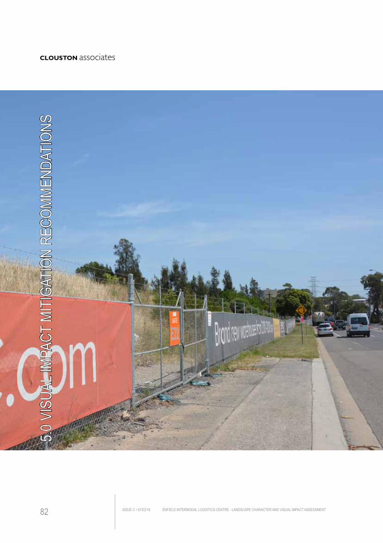
5.0 V
ISUA
L IMP
ACT
MITI
GATI
ON R
ECOM
MEND
ATIO
NS
ENFIELD INTERMODAL LOGISTICS CENTRE - LANDSCAPE CHARACTER AND VISUAL IMPACT ASSESSMENTISSUE C • 07/02/1882
5.1 APPROACHES TO MITIGATIONThere are typically four broad approaches to mitigating the visual impacts of any change to a scene that entails built form development. These are through:
• Avoidance – where the visual impact of the proposal is deemed of a scale that cannot be mitigated by any of the approaches outlined below, this approach implies relocating the proposal elsewhere on or outside the Project site with lesser visual impacts or not proceeding with the proposal on the site at all
• Reduction – typically this approach seeks to mitigate impacts through the reduction of some part of the proposed structure or development (ie. reduced height, downscaling or omission of parts of the built structure/s)
• Alleviation – this approach entails design refinements to the proposal to mitigate visual impacts. These refinements might typically include built form articulation, choice of material reflectivity alleviation, colour choices and/or planting design
• Offsite Compensation – where none of the above approaches will provide adequate visual impact mitigation for offsite visual receptors, this approach entails offsite works on the land from which the viewpoint is experienced (eg screening close to the viewpoint).
Set out below are the relevant responses to these approaches with respect to the Project.
5.1.1 Applicability of Mitigation to the Planning ProposalGiven that the new proposed built form will stand on the site with a similar character and the additional building height would not have significant adverse impact on its surrounding context, the need for Avoidance, Reduction or Offsite Compensation would not be warranted.
Consequently, options to alleviate impacts are will be most relevant with detailed design features such as materials, finishes, reflectivity, planting character and the like being the principal mitigation measures. Measures to be incorporated include:
5.1.2 Planting MitigationThe original Environmental Assessment (EA 2005) provided a series of mitigation measures to reduce the visibility of the proposed development. These measures were primarily comprised of screen planting along the Marshalling Yard on the western boundary, a belt of planting around the light industrial area and the 50m wide planting groups in between Punchbowl Road and the existing mound.
Since the plan has been modified and updated, some of those treatments are no longer reflected in the latest proposal and Masterplan. ( See Figure 1.3)
The latest concept design of the Project has also been prepared to coordinate with proposed warehouses and worked to reduce visual impact through the :• planting plan around proposed warehouses (See Figure 2.4)
ENFIELD INTERMODAL LOGISTICS CENTRE - LANDSCAPE CHARACTER AND VISUAL IMPACT ASSESSMENT ISSUE C • 07/02/18 83
5. VISUAL IMPACT MITIGATION
Further measures to be considered include: • plant additional native trees and shrubs in parallel with Cosgrove Road to screen
built form and reduce the scale of the development.
• plant more trees along western perimeter of the site to reduce visibility of the Project
5.1.3 Built Form / Finishes • avoid overly reflective surfaces
• use neutral colours to reduce visual contrast in more visible area
• ensure the aesthetic quality of the buildings and other facilities to make sure the Project fits with the local context and existing visual environment
5.1.4 Night time uses and Light spillA Light spill assessment has carried out for the 2005 report and it is considered that these findings would still apply to the report.
5.1.5 Construction phaseVisual impacts during the construction phases will be temporary in nature (Compounds, cranes, lighting, parking, etc) and therefore on site mitigation measures would not appear warranted. However, it is recommended that high quality graphic panels be added to site fencing particularly residential areas, such as are already used (See Photomontage Viewpoint 12), to create a less cluttered more appealing views for the public vista at the ends of streets will be most important for such measures.
ENFIELD INTERMODAL LOGISTICS CENTRE - LANDSCAPE CHARACTER AND VISUAL IMPACT ASSESSMENTISSUE C • 07/02/1884
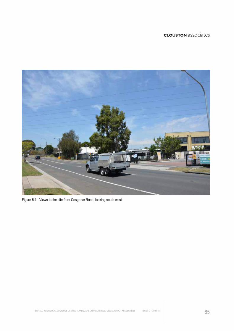
Figure 5.1 - Views to the site from Cosgrove Road, looking south west
ENFIELD INTERMODAL LOGISTICS CENTRE - LANDSCAPE CHARACTER AND VISUAL IMPACT ASSESSMENT ISSUE C • 07/02/18 85
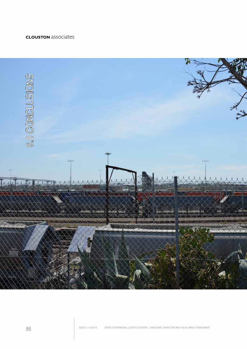
6.0 C
ONCL
USIO
NS
ENFIELD INTERMODAL LOGISTICS CENTRE - LANDSCAPE CHARACTER AND VISUAL IMPACT ASSESSMENTISSUE C • 07/02/1886
The foregoing analysis of the landscape character and visual impacts of the proposed development of Enfield Intermodal Logistics Centre have identified that:• The proposed future construction would generally be consistent with or similar to
the character of the existing terminal areas
• The highest visual impact is found at Southern Precinct Lookout. This is where people can enjoy the view of the new logistics centre development. Without causing any significantly adverse visual impact, the Lookout has the best panoramic view of the Project site, as was its original design intent.
• Several prominent views of the proposed development would occur along the boundary of industrial/commercial development on the western and eastern of the site, however, due to the high compatibility with existing industrial/commercial landscape, the visual impacts from these locations are assessed as Moderate/Low
• The majority of residential areas with potential view towards the site in the immediate vicinity would be Low/Negligible because the built form and associated planting would largely obscure views to the site and buildings
• Views to the Project from public parks are negligible and thus impacts overall from these locations are rated Negligible.
Despite some of the viewpoints experiencing Moderate visual impacts, the overall visual impacts would generally be Low, effecting views from the adjoining industrial/ commercial towards the Project, more than from public spaces viewpoints.
While the Concept Masterplan for the proposal includes some generous landscape areas in close proximity to proposed warehouses, it is suggested that, if possible, it would be important to propose tree planting in front of industrial and commercial area running parallel to Cosgrove Road to provide screening effect for users of Cosgrove Road.
ENFIELD INTERMODAL LOGISTICS CENTRE - LANDSCAPE CHARACTER AND VISUAL IMPACT ASSESSMENT ISSUE C • 07/02/18 87
6. CONCLUSIONS
APPENDIX APHOTOMONTAGES
ENFIELD INTERMODAL LOGISTICS CENTRE - LANDSCAPE CHARACTER AND VISUAL IMPACT ASSESSMENTISSUE C • 07/02/1888
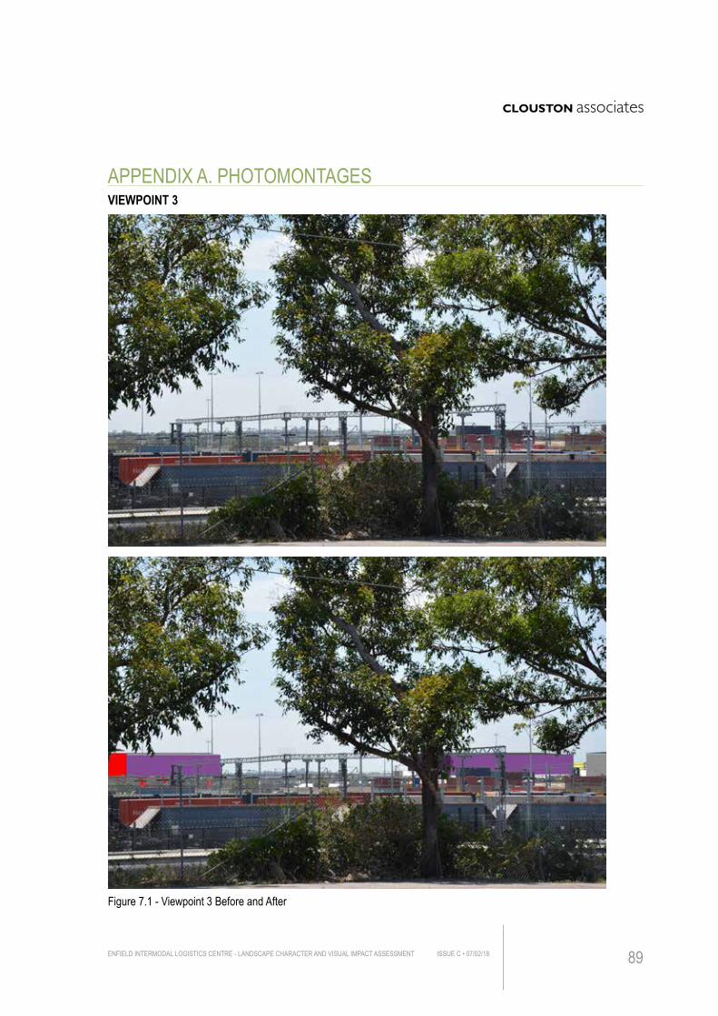
Figure 7.1 - Viewpoint 3 Before and After
VIEWPOINT 3
ENFIELD INTERMODAL LOGISTICS CENTRE - LANDSCAPE CHARACTER AND VISUAL IMPACT ASSESSMENT ISSUE C • 07/02/18 89
APPENDIX A. PHOTOMONTAGES
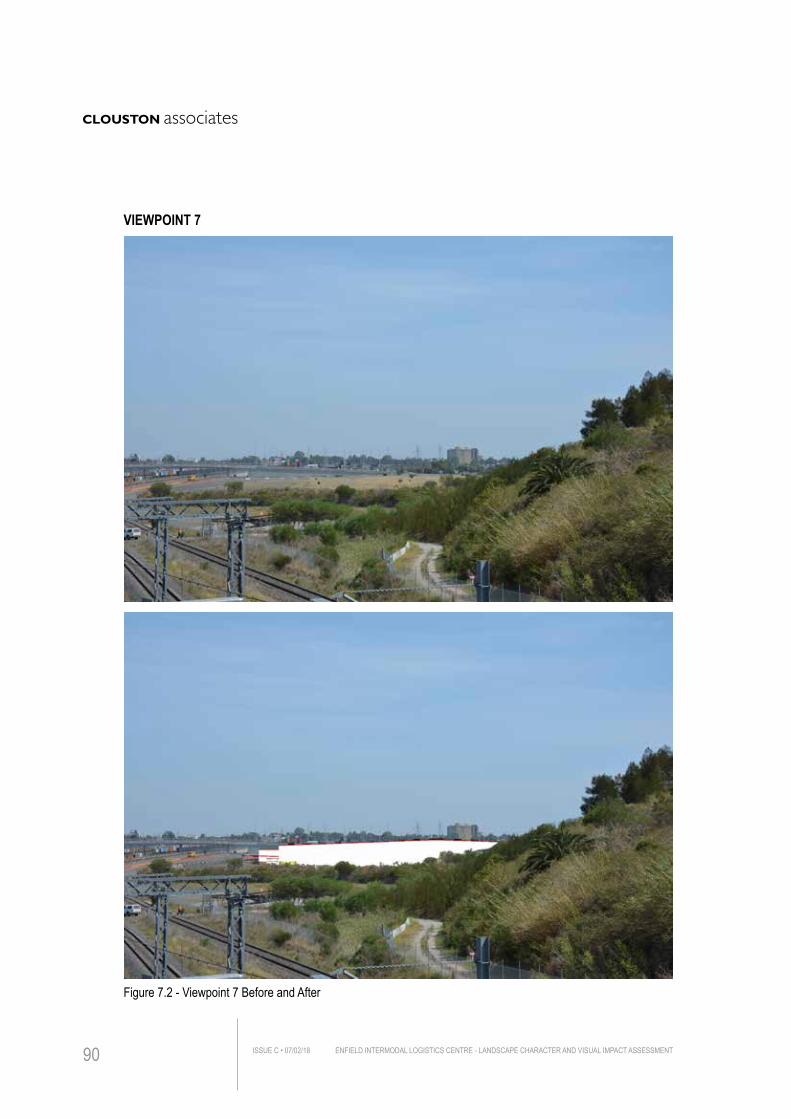
Figure 7.2 - Viewpoint 7 Before and After
VIEWPOINT 7
ENFIELD INTERMODAL LOGISTICS CENTRE - LANDSCAPE CHARACTER AND VISUAL IMPACT ASSESSMENTISSUE C • 07/02/1890
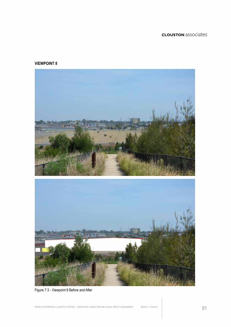
Figure 7.3 - Viewpoint 8 Before and After
VIEWPOINT 8
ENFIELD INTERMODAL LOGISTICS CENTRE - LANDSCAPE CHARACTER AND VISUAL IMPACT ASSESSMENT ISSUE C • 07/02/18 91
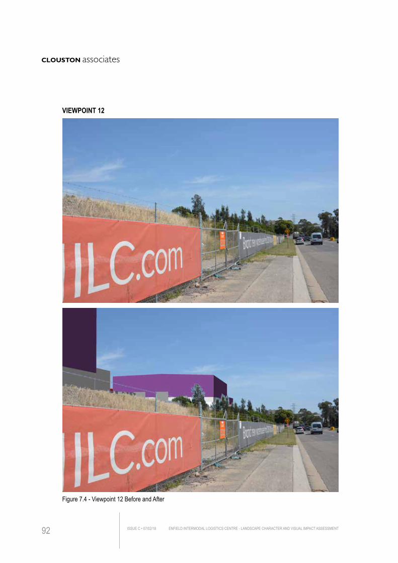
Figure 7.4 - Viewpoint 12 Before and After
VIEWPOINT 12
ENFIELD INTERMODAL LOGISTICS CENTRE - LANDSCAPE CHARACTER AND VISUAL IMPACT ASSESSMENTISSUE C • 07/02/1892
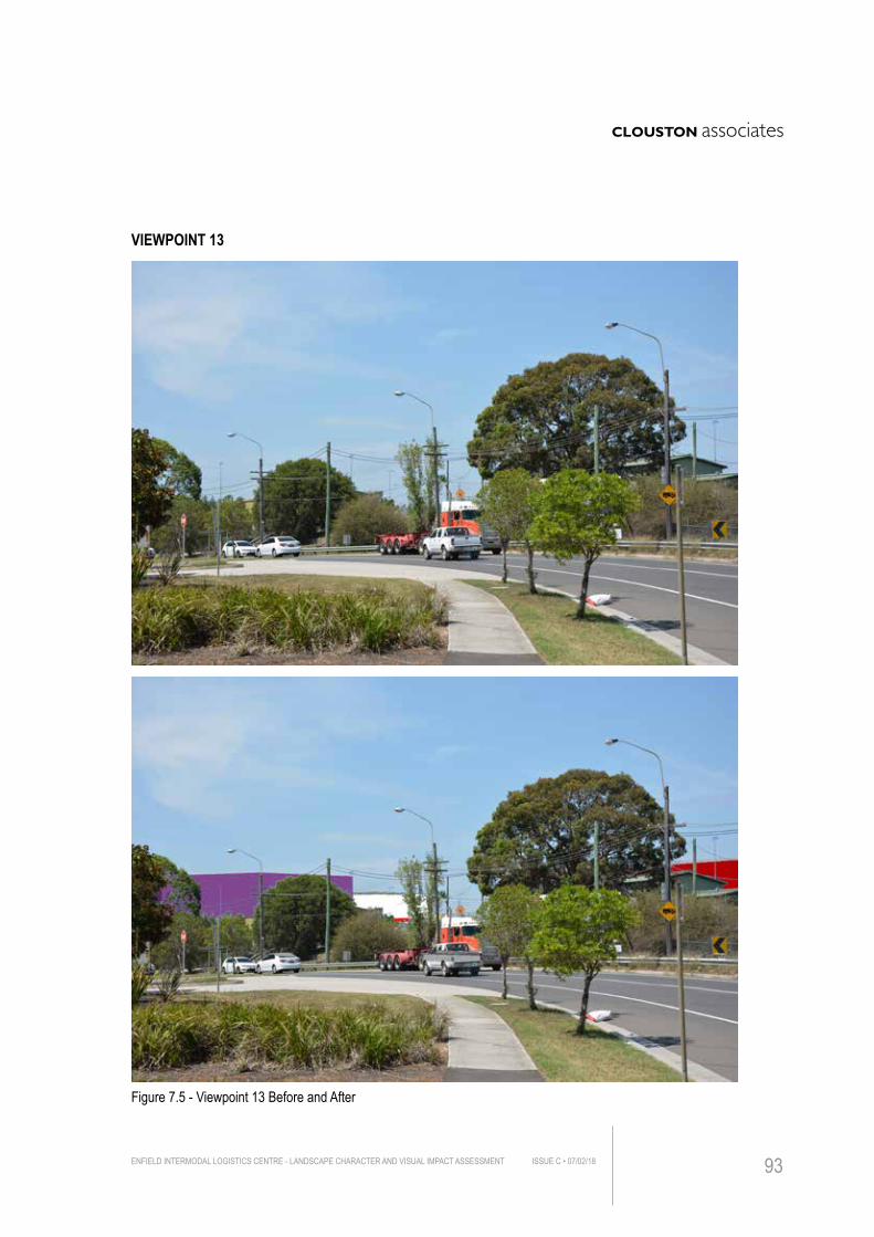
Figure 7.5 - Viewpoint 13 Before and After
VIEWPOINT 13
ENFIELD INTERMODAL LOGISTICS CENTRE - LANDSCAPE CHARACTER AND VISUAL IMPACT ASSESSMENT ISSUE C • 07/02/18 93
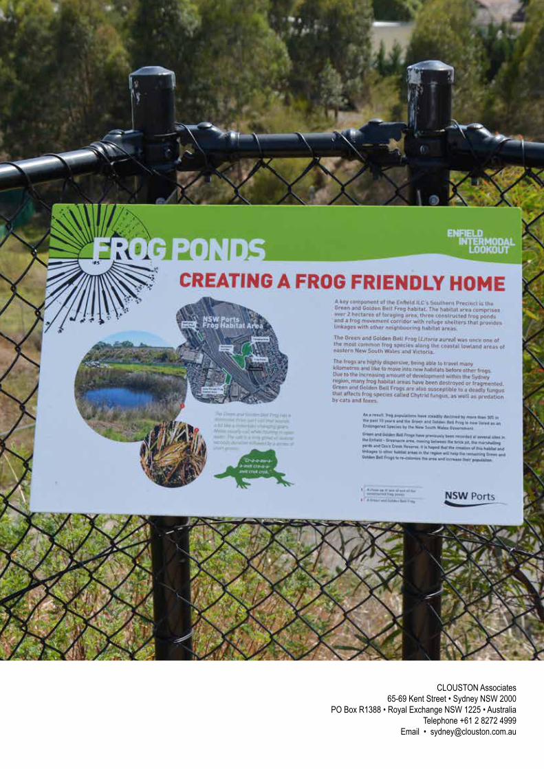
CLOUSTON Associates65-69 Kent Street • Sydney NSW 2000
PO Box R1388 • Royal Exchange NSW 1225 • AustraliaTelephone +61 2 8272 4999
Email • [email protected]