Embed Size (px)
Citation preview
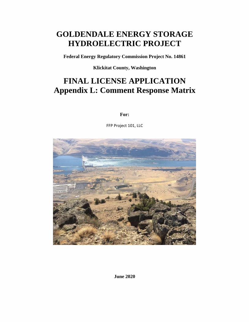
GOLDENDALE ENERGY STORAGE HYDROELECTRIC PROJECT
Federal Energy Regulatory Commission Project No. 14861
Klickitat County, Washington
FINAL LICENSE APPLICATION Appendix L: Comment Response Matrix
For:
FFP Project 101, LLC
June 2020
Final License Application Appendix L
Goldendale Energy Storage Project FFP Project 101, LLC FERC Project No. 14861 Page i June 2020
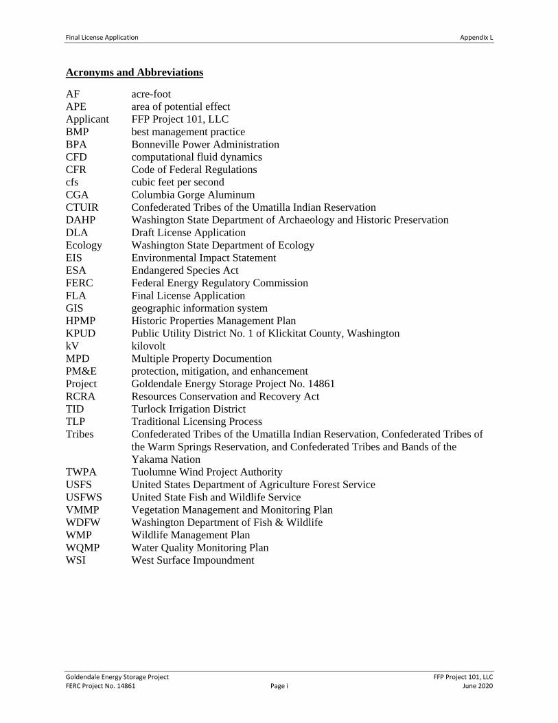
Acronyms and Abbreviations
AF acre-foot APE area of potential effect Applicant FFP Project 101, LLC BMP best management practice BPA Bonneville Power Administration CFD computational fluid dynamics CFR Code of Federal Regulations cfs cubic feet per second CGA Columbia Gorge Aluminum CTUIR Confederated Tribes of the Umatilla Indian Reservation DAHP Washington State Department of Archaeology and Historic Preservation DLA Draft License Application Ecology Washington State Department of Ecology EIS Environmental Impact Statement ESA Endangered Species Act FERC Federal Energy Regulatory Commission FLA Final License Application GIS geographic information system HPMP Historic Properties Management Plan KPUD Public Utility District No. 1 of Klickitat County, Washington kV kilovolt MPD Multiple Property Documention PM&E protection, mitigation, and enhancement Project Goldendale Energy Storage Project No. 14861 RCRA Resources Conservation and Recovery Act TID Turlock Irrigation District TLP Traditional Licensing Process Tribes Confederated Tribes of the Umatilla Indian Reservation, Confederated Tribes of
the Warm Springs Reservation, and Confederated Tribes and Bands of the Yakama Nation
TWPA Tuolumne Wind Project Authority USFS United States Department of Agriculture Forest Service USFWS United State Fish and Wildlife Service VMMP Vegetation Management and Monitoring Plan WDFW Washington Department of Fish & Wildlife WMP Wildlife Management Plan WQMP Water Quality Monitoring Plan WSI West Surface Impoundment
Final License Application Appendix L
Goldendale Energy Storage Project FFP Project 101, LLC FERC Project No. 14861 Page 1 June 2020
Commentor/ Date
Comment Code
FLA Section Comment Applicant Response
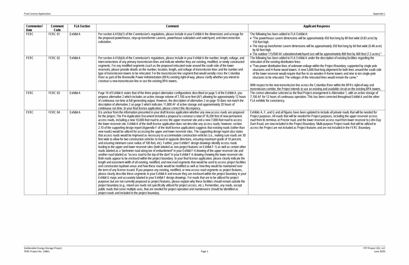
FERC FERC 01 Exhibit A Per section 4.41(b)(1) of the Commission’s regulations, please include in your Exhibit A the dimensions and acreage for the proposed powerhouse, step-up transformer caverns, powerhouse substation and switchyard, and interconnection substation.
The following has been added to FLA Exhibit A: • “The powerhouse cavern dimensions will be approximately 450 feet long by 80 feet wide (0.83 acre) by
150 feet high. • The step-up transformer cavern dimensions will be approximately 350 feet long by 60 feet wide (0.48 acre)
by 60 feet high. • The outdoor 115/500 kV substation/switchyard size will be approximately 800 feet by 400 feet (7.3 acres).”
FERC FERC 02 Exhibit A Per section 4.41(b)(4) of the Commission’s regulations, please include in your Exhibit A the number, length, voltage, and interconnections of any primary transmission lines and indicate whether they are existing, modified, or newly constructed segments. For any modified segments (such as the proposed relocated route around the south side of the lower reservoir), please provide details on the number, location, length, and voltage of transmission lines and the number and type of transmission towers to be relocated. For the transmission line segment that would aerially cross the Columbia River as part of the Bonneville Power Administration (BPA) existing right-of-way, please clarify whether you intend to construct a new transmission line or use the existing BPA towers.
The following has been added to FLA Exhibit A under the description of existing facilities regarding the relocation of the existing distribution lines: • “Two power distribution lines of unknown voltage within the Project Boundary, supported by single pole
structures and H-frame wood towers. A new 5,600-foot-long alignment for both lines around the south side of the lower reservoir would require that five to six wooden H-frame towers and nine to ten single-pole structures to be relocated. The voltages of the relocated lines would remain the same.”
With respect to the new transmission line across the Columbia River within the BPA's right-of-way and transmission corridor, the Project intends to use an existing and available circuit on the existing BPA towers.
FERC FERC 03 Exhibit A Page 10 of Exhibit A states that of the three project alternative configurations described on page 5 of the Exhibit A, you propose alternative 2 which includes an active storage volume of 7,100 acre-feet (AF) allowing for approximately 12 hours of continuous run time at full generating output. However, the description of alternative 2 on page 10 does not match the description of alternative 2 on page 5 which indicates 11,800 AF of active storage and approximately 20 hours of continuous run time. In your final license application, please correct this discrepancy.
The correct alternative selected as the final Project arrangement is Alternative 1, with an active storage of 7,100 AF for 12 hours of continuous operation. This has been corrected throughout Exhibit A and the other FLA exhibits for consistency.
FERC FERC 04 Exhibit A It is unclear from the information presented in your draft license application whether any new access roads are proposed for the project. The Pre-Application Document included a proposal to construct a total of 18,200 feet of new permanent access roads, including a new 10,000-foot road to access the upper reservoir site and a new 7,000-foot road to access the lower reservoir site. Exhibit A of the draft license application does not describe any access roads; however, section 2.10 of the supporting design report (Appendix F of the draft license application) suggests that existing roads (rather than new roads) would be utilized for accessing the upper and lower reservoir sites. The supporting design report also states that access roads would be improved as necessary to accommodate construction vehicles (i.e., making sure roads are 30 feet wide to allow for two construction vehicles to travel in opposite directions, ensuring maximum grade of 10 percent, and ensuring minimum curve radius of 100 feet, etc). Further, your Exhibit F design drawings identify access roads leading to the upper and lower reservoir sites (both labeled as non-project features on Exhibit F-1) as well as certain other roads labeled as a “perimeter road along toe of embankment” in your Exhibit F-4 drawing of the upper reservoir site and another road labeled as “access road to the top of the dam” in your Exhibit F-6 drawing showing the lower reservoir site. Both roads appear to be enclosed within the project boundary. In your final license application, please clearly indicate the length and easement width of all existing, modified, and new road segments that would be used to access project facilities and construction laydown areas and how these roads would be modified as well as how they would be maintained over the term of any license issued. If you propose any existing, modified, or new access road segments as project features, please clearly describe these segments in your Exhibit A and ensure they are enclosed within the project boundary in your Exhibit G maps and accurately labeled in your Exhibit F design drawings. For roads that are to be utilized for project purposes but are not currently proposed as project features, please explain why these facilities should remain outside the project boundary (e.g., mixed use roads not specifically utilized for project access, etc.). Remember, any roads, except public roads that serve multiple uses, that are needed for project operation and maintenance should be identified as project roads and included in the project boundary.
Exhibits A, F, and G and all figures have been updated to include all private roads that will be needed for Project purposes. All roads that will be needed for Project purposes, including the upper reservoir access road from its terminus at Proctor road, and the lower reservoir access road from lower reservoir to John Day Dam Road, are now included in the Project Boundary. Multi-purpose Project roads that will be utilized to access the Project are not included as Project features and are not included in the FERC Boundary.
Final License Application Appendix L
Goldendale Energy Storage Project FFP Project 101, LLC FERC Project No. 14861 Page 2 June 2020
Commentor/ Date
Comment Code
FLA Section Comment Applicant Response
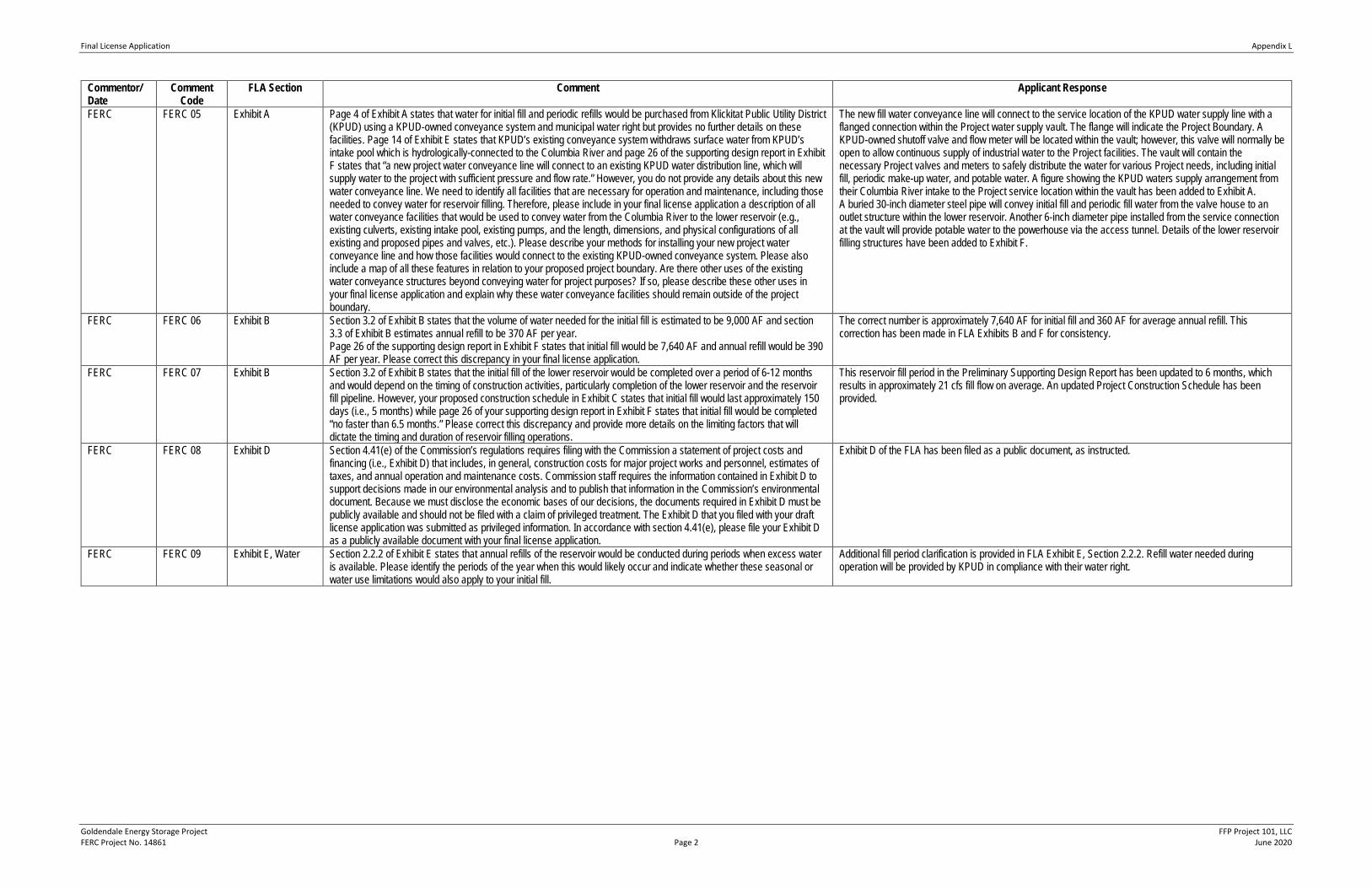
FERC FERC 05 Exhibit A Page 4 of Exhibit A states that water for initial fill and periodic refills would be purchased from Klickitat Public Utility District (KPUD) using a KPUD-owned conveyance system and municipal water right but provides no further details on these facilities. Page 14 of Exhibit E states that KPUD’s existing conveyance system withdraws surface water from KPUD’s intake pool which is hydrologically-connected to the Columbia River and page 26 of the supporting design report in Exhibit F states that “a new project water conveyance line will connect to an existing KPUD water distribution line, which will supply water to the project with sufficient pressure and flow rate.” However, you do not provide any details about this new water conveyance line. We need to identify all facilities that are necessary for operation and maintenance, including those needed to convey water for reservoir filling. Therefore, please include in your final license application a description of all water conveyance facilities that would be used to convey water from the Columbia River to the lower reservoir (e.g., existing culverts, existing intake pool, existing pumps, and the length, dimensions, and physical configurations of all existing and proposed pipes and valves, etc.). Please describe your methods for installing your new project water conveyance line and how those facilities would connect to the existing KPUD-owned conveyance system. Please also include a map of all these features in relation to your proposed project boundary. Are there other uses of the existing water conveyance structures beyond conveying water for project purposes? If so, please describe these other uses in your final license application and explain why these water conveyance facilities should remain outside of the project boundary.
The new fill water conveyance line will connect to the service location of the KPUD water supply line with a flanged connection within the Project water supply vault. The flange will indicate the Project Boundary. A KPUD-owned shutoff valve and flow meter will be located within the vault; however, this valve will normally be open to allow continuous supply of industrial water to the Project facilities. The vault will contain the necessary Project valves and meters to safely distribute the water for various Project needs, including initial fill, periodic make-up water, and potable water. A figure showing the KPUD waters supply arrangement from their Columbia River intake to the Project service location within the vault has been added to Exhibit A. A buried 30-inch diameter steel pipe will convey initial fill and periodic fill water from the valve house to an outlet structure within the lower reservoir. Another 6-inch diameter pipe installed from the service connection at the vault will provide potable water to the powerhouse via the access tunnel. Details of the lower reservoir filling structures have been added to Exhibit F.
FERC FERC 06 Exhibit B Section 3.2 of Exhibit B states that the volume of water needed for the initial fill is estimated to be 9,000 AF and section 3.3 of Exhibit B estimates annual refill to be 370 AF per year. Page 26 of the supporting design report in Exhibit F states that initial fill would be 7,640 AF and annual refill would be 390 AF per year. Please correct this discrepancy in your final license application.
The correct number is approximately 7,640 AF for initial fill and 360 AF for average annual refill. This correction has been made in FLA Exhibits B and F for consistency.
FERC FERC 07 Exhibit B Section 3.2 of Exhibit B states that the initial fill of the lower reservoir would be completed over a period of 6-12 months and would depend on the timing of construction activities, particularly completion of the lower reservoir and the reservoir fill pipeline. However, your proposed construction schedule in Exhibit C states that initial fill would last approximately 150 days (i.e., 5 months) while page 26 of your supporting design report in Exhibit F states that initial fill would be completed “no faster than 6.5 months.” Please correct this discrepancy and provide more details on the limiting factors that will dictate the timing and duration of reservoir filling operations.
This reservoir fill period in the Preliminary Supporting Design Report has been updated to 6 months, which results in approximately 21 cfs fill flow on average. An updated Project Construction Schedule has been provided.
FERC FERC 08 Exhibit D Section 4.41(e) of the Commission’s regulations requires filing with the Commission a statement of project costs and financing (i.e., Exhibit D) that includes, in general, construction costs for major project works and personnel, estimates of taxes, and annual operation and maintenance costs. Commission staff requires the information contained in Exhibit D to support decisions made in our environmental analysis and to publish that information in the Commission’s environmental document. Because we must disclose the economic bases of our decisions, the documents required in Exhibit D must be publicly available and should not be filed with a claim of privileged treatment. The Exhibit D that you filed with your draft license application was submitted as privileged information. In accordance with section 4.41(e), please file your Exhibit D as a publicly available document with your final license application.
Exhibit D of the FLA has been filed as a public document, as instructed.
FERC FERC 09 Exhibit E, Water Section 2.2.2 of Exhibit E states that annual refills of the reservoir would be conducted during periods when excess water is available. Please identify the periods of the year when this would likely occur and indicate whether these seasonal or water use limitations would also apply to your initial fill.
Additional fill period clarification is provided in FLA Exhibit E, Section 2.2.2. Refill water needed during operation will be provided by KPUD in compliance with their water right.
Final License Application Appendix L
Goldendale Energy Storage Project FFP Project 101, LLC FERC Project No. 14861 Page 3 June 2020
Commentor/ Date
Comment Code
FLA Section Comment Applicant Response
FERC FERC 10 Exhibit E, Water and Geology
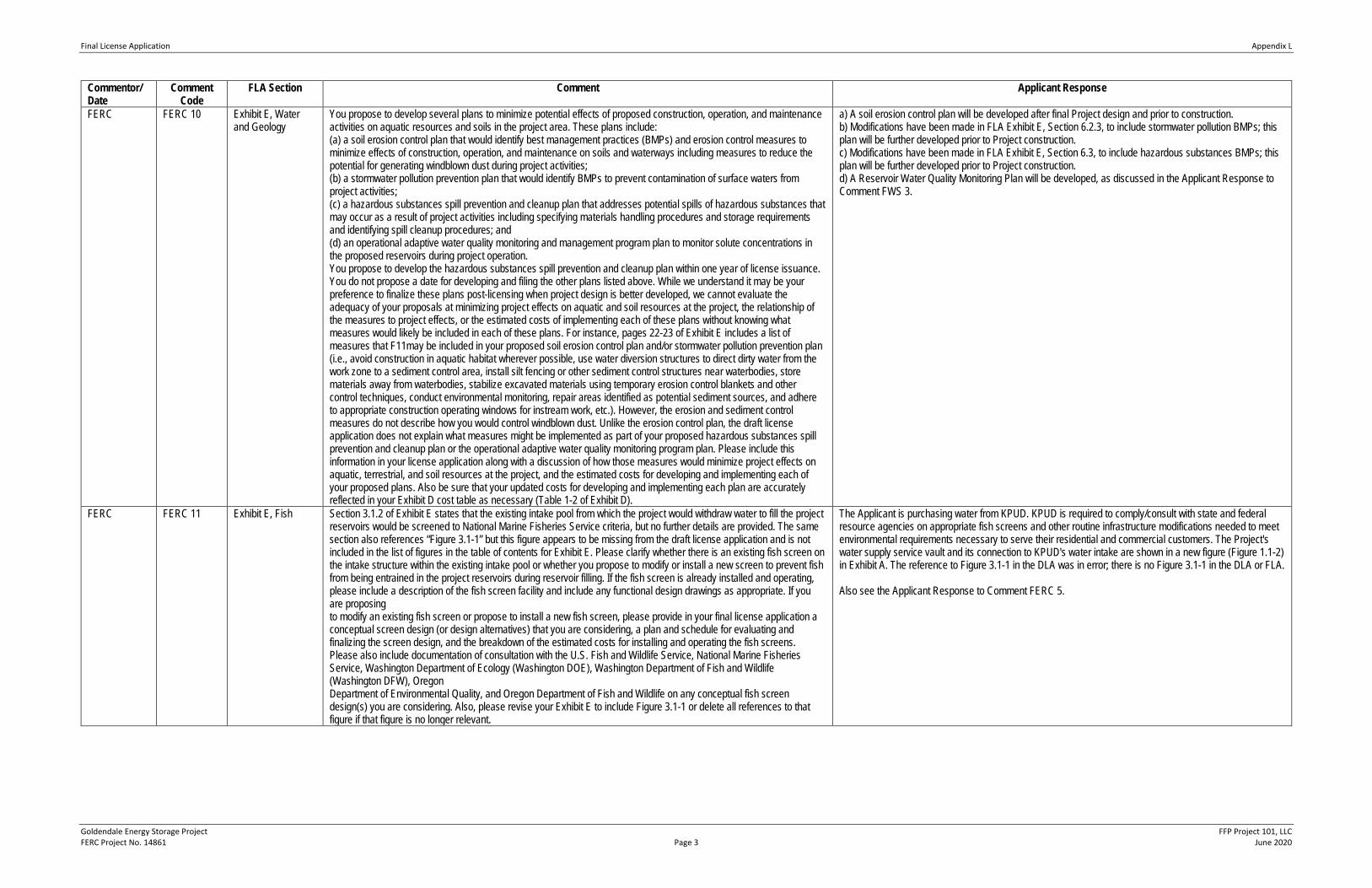
You propose to develop several plans to minimize potential effects of proposed construction, operation, and maintenance activities on aquatic resources and soils in the project area. These plans include: (a) a soil erosion control plan that would identify best management practices (BMPs) and erosion control measures to minimize effects of construction, operation, and maintenance on soils and waterways including measures to reduce the potential for generating windblown dust during project activities; (b) a stormwater pollution prevention plan that would identify BMPs to prevent contamination of surface waters from project activities; (c) a hazardous substances spill prevention and cleanup plan that addresses potential spills of hazardous substances that may occur as a result of project activities including specifying materials handling procedures and storage requirements and identifying spill cleanup procedures; and (d) an operational adaptive water quality monitoring and management program plan to monitor solute concentrations in the proposed reservoirs during project operation. You propose to develop the hazardous substances spill prevention and cleanup plan within one year of license issuance. You do not propose a date for developing and filing the other plans listed above. While we understand it may be your preference to finalize these plans post-licensing when project design is better developed, we cannot evaluate the adequacy of your proposals at minimizing project effects on aquatic and soil resources at the project, the relationship of the measures to project effects, or the estimated costs of implementing each of these plans without knowing what measures would likely be included in each of these plans. For instance, pages 22-23 of Exhibit E includes a list of measures that F11may be included in your proposed soil erosion control plan and/or stormwater pollution prevention plan (i.e., avoid construction in aquatic habitat wherever possible, use water diversion structures to direct dirty water from the work zone to a sediment control area, install silt fencing or other sediment control structures near waterbodies, store materials away from waterbodies, stabilize excavated materials using temporary erosion control blankets and other control techniques, conduct environmental monitoring, repair areas identified as potential sediment sources, and adhere to appropriate construction operating windows for instream work, etc.). However, the erosion and sediment control measures do not describe how you would control windblown dust. Unlike the erosion control plan, the draft license application does not explain what measures might be implemented as part of your proposed hazardous substances spill prevention and cleanup plan or the operational adaptive water quality monitoring program plan. Please include this information in your license application along with a discussion of how those measures would minimize project effects on aquatic, terrestrial, and soil resources at the project, and the estimated costs for developing and implementing each of your proposed plans. Also be sure that your updated costs for developing and implementing each plan are accurately reflected in your Exhibit D cost table as necessary (Table 1-2 of Exhibit D).
a) A soil erosion control plan will be developed after final Project design and prior to construction. b) Modifications have been made in FLA Exhibit E, Section 6.2.3, to include stormwater pollution BMPs; this plan will be further developed prior to Project construction. c) Modifications have been made in FLA Exhibit E, Section 6.3, to include hazardous substances BMPs; this plan will be further developed prior to Project construction. d) A Reservoir Water Quality Monitoring Plan will be developed, as discussed in the Applicant Response to Comment FWS 3.
FERC FERC 11 Exhibit E, Fish Section 3.1.2 of Exhibit E states that the existing intake pool from which the project would withdraw water to fill the project reservoirs would be screened to National Marine Fisheries Service criteria, but no further details are provided. The same section also references “Figure 3.1-1” but this figure appears to be missing from the draft license application and is not included in the list of figures in the table of contents for Exhibit E. Please clarify whether there is an existing fish screen on the intake structure within the existing intake pool or whether you propose to modify or install a new screen to prevent fish from being entrained in the project reservoirs during reservoir filling. If the fish screen is already installed and operating, please include a description of the fish screen facility and include any functional design drawings as appropriate. If you are proposing to modify an existing fish screen or propose to install a new fish screen, please provide in your final license application a conceptual screen design (or design alternatives) that you are considering, a plan and schedule for evaluating and finalizing the screen design, and the breakdown of the estimated costs for installing and operating the fish screens. Please also include documentation of consultation with the U.S. Fish and Wildlife Service, National Marine Fisheries Service, Washington Department of Ecology (Washington DOE), Washington Department of Fish and Wildlife (Washington DFW), Oregon Department of Environmental Quality, and Oregon Department of Fish and Wildlife on any conceptual fish screen design(s) you are considering. Also, please revise your Exhibit E to include Figure 3.1-1 or delete all references to that figure if that figure is no longer relevant.
The Applicant is purchasing water from KPUD. KPUD is required to comply/consult with state and federal resource agencies on appropriate fish screens and other routine infrastructure modifications needed to meet environmental requirements necessary to serve their residential and commercial customers. The Project's water supply service vault and its connection to KPUD's water intake are shown in a new figure (Figure 1.1-2) in Exhibit A. The reference to Figure 3.1-1 in the DLA was in error; there is no Figure 3.1-1 in the DLA or FLA. Also see the Applicant Response to Comment FERC 5.
Final License Application Appendix L
Goldendale Energy Storage Project FFP Project 101, LLC FERC Project No. 14861 Page 4 June 2020
FERC FERC 12 Exhibit E, Geology Portions of the project’s proposed infrastructure would be located on the site of the former Columbia Gorge Aluminum smelter, which is now a Resource Conservation and Recovery Act (RCRA) contaminated site. The site, currently owned by NSC Smelter, LLC, is the subject of ongoing clean-up by Washington DOE.1 The Commission has previously stated that it will only consider development applications for sites undergoing a RCRA or Superfund cleanup process once the relevant state or federal agency certifies that cleanup is complete. As part of your preliminary permit application, FFP Project 101, LLC provided evidence that Washington DOE supported the project and believed that its construction and operation would not hinder the cleanup process.2 Likewise, in a March 8, 2018, order issuing a permit for the project, Commission staff found that FFP Project 101, LLC had sufficiently demonstrated that the project area—including all lands needed for project construction and operation—did not include any lands subject to further cleanup by Washington DOE. Nonetheless, Commission staff required that FFP Project 101, LLC pursue progress during the permit term and in any future licensing process without adversely impacting ongoing cleanup activities by Washington DOE and provided that should FFP Project 101, LLC begin the process of developing a license application for the project, it would be required to demonstrate that licensing would not result in any issues arising from contamination in the project area. Section 6.2.1 of Exhibit E states that within the proposed project boundary, the lower reservoir would be located within the footprint of Solid Waste Management Unit (SWMU) number 4 also known as the West Surface Impoundment.3 In 2004, the West Surface Impoundment was closed under RCRA and in 2005 Washington DOE accepted certification for the closure of the site. The site contains approximately 89,000 cubic yards of sludge comprised primarily of alumina, dust, and particulates from wastewater and residual waste generated by plant emission control systems. Closure of the West Surface Impoundment included placement of an engineered RCRA cap consisting of soil and geosynthetic materials and development of a post-closure maintenance and groundwater monitoring plan4 which requires quarterly sampling beginning in 2005 for two years, followed by semi-annual sampling for years 3 through 7, and annual sampling thereafter until concentrations drop below groundwater protection standards, or for a maximum of 30 years.5 According to the most recent available groundwater monitoring report for the site, chloride and total cyanide concentrations were below groundwater protection standards while sulfate and fluoride remain above protection standards suggesting that the West Surface Impoundment is continuing to contribute these contaminates to groundwater albeit at a much lower rate than concentrations observed prior to closure of the site.6 The Exhibit E also states that the West Surface Impoundment site is known to contain non-hazardous waste materials that would be permanently removed and disposed of offsite during construction of the lower reservoir. To guide this effort, you propose to negotiate a scope of work and consent decree with Washington DOE to govern the removal and off-site disposal of the West Surface Impoundment materials, including the liner and cover system once all other materials are removed from the site during construction of the lower reservoir. Section 6.2.1 of Exhibit E further suggests that removal and offsite disposal of the contents associated with the West Surface Impoundment would require the decommissioning of eight groundwater monitoring wells, which would be replaced following construction. The West Surface Impoundment is the only site mentioned in the draft license application with monitoring pursuant to the RCRA cleanup. However, the most recent report concerning the cleanup effort7 states the following regarding the project: “Some of the pumped storage facilities (including the lower reservoir, power plant, water supply lines, and transmission lines) have previously been proposed in the areas of SWMUs and [Area of Concerns] being investigated as part of the [Remedial Investigation]. Of particular potential concern from a site cleanup perspective, the following sites are in the vicinity of the lower reservoir in prior proposals for the pumped storage project including: l) the [West Surface Impoundment] (SWMU 4), which has already been closed under RCRA; 2) the West SPL Storage Area (SWMU 13), which has been closed under Washington State Solid Waste Regulations, and; 3) the Plant Construction Landfill (SWMU 19). Construction of the lower reservoir could also potentially significantly affect groundwater recharge and flow.” In addition to the SWMUs located near the lower reservoir site, the report states that a ditch on the southern end of SWMU 13 and adjacent to the lower reservoir contains elevated levels of polycyclic aromatic hydrocarbon (PAH) soil concentrations (see table 34-1 in Volume 2 of the report) and that multiple groundwater monitoring wells near the lower reservoir site contained elevated levels of total cyanide in addition to fluoride and sulfate (see figures 2-26, 2-29, 2-32, and 2-33 of Volume 3 of the 2019 report). The report recommended both the ditch on the southern end of West SPL Storage Area and groundwater in the uppermost aquifer8 undergo further testing and evaluation as part of the next phase of the feasibility study which would form the basis for a draft cleanup action plan. Your draft application fails to demonstrate that construction and operation of the project would not adversely impact ongoing cleanup activities by Washington DOE and would not result in any issues arising from contamination in the project area. For example, you defer to post-licensing efforts that could demonstrate that clean-up efforts would proceed unencumbered by project development (e.g., negotiating a scope of work and consent decree with Washington DOE to govern the removal and off-site disposal of the contents of the West Surface Impoundment materials and development of procedures for
Additions have been made to FLA Exhibit E, Section 6.3, to address FERC's concerns regarding the RCRA contaminated site within the Project footprint.
Final License Application Appendix L
Goldendale Energy Storage Project FFP Project 101, LLC FERC Project No. 14861 Page 5 June 2020
Commentor/ Date
Comment Code
FLA Section Comment Applicant Response
decommissioning and relocating groundwater monitoring wells). Further, the draft license application does not describe how project construction and operation would affect the following Washington DOE-monitored sites near the project: (1) SWMU 13 – West SPL Storage Area; (2) the ditch on the southern end of SWMU 13; (3) SWMU 19 – Plant Construction Landfill; and (4) specific groundwater wells near the lower reservoir site that are undergoing additional evaluations by Washington DOE. In your final license application, you must explain in greater detail how construction and operation of the project would not adversely impact ongoing cleanup activities and would not result in any issues arising from contamination in the project area. Specifically, you must include a detailed plan for the removal and disposal of materials from the West Surface Impoundment (SWMU 4) and any other site that you determine would be affected by construction; a description of how you would avoid disturbing other sites containing hazardous material still subject to clean-up efforts (particularly during construction of the proposed lower reservoir and new water conveyance line, etc.); and a monitoring well decommission and relocation plan that includes specific steps and procedures you propose for both removal and/or relocation of certain existing monitoring wells in order to construct the lower reservoir and other ancillary facilities. Further you must consult with Washington DOE concerning your proposed plans and measures prior to filing them with the Commission. Your filing should include the results of such consultation, including any agreements with Washington DOE or, recommendations from the agency that you have considered but rejected and the basis for such rejection. Your final license application should also include an updated map showing the location of CGA smelter contamination sites in relation to the project boundary (please show all SWMUs and any additional sites subject to further study). The map should also show the locations of the sites in relation to all water conveyance facilities (both new and existing) that would be used to convey water from the Columbia River to the lower reservoir for initial fill and annual refills and also identify all groundwater monitoring wells that are proposed for relocation.
FERC FERC 13 Exhibit E, Geology FOOTNOTES FOR FERC #12 1 Past smelter operations contaminated the soil and groundwater with fluoride, polycyclic aromatic hydrocarbons, cyanide, and polychlorinated biphenyls. The site was added to the State of Washington’s Hazardous Sites list in 1990. The Washington DOE is currently working with the potentially liable persons (i.e., NSC Smelter, Inc. and Lockheed Martin Corporation) to investigate and cleanup the site. The requirements of the 2014 Agreed Order No. DE 10483 issued by Washington DOE requires development of a Remedial Investigation Work Plan to screen and select potential sites for further investigation (i.e., identify and delineate Solid Waste Management Units and Areas of Concern), conduct a Remedial Investigation/Feasibility Study to determine the nature and extent of contamination at the selected sites and develop a range of cleanup alternatives, and develop a Draft Cleanup Action Plan to identify preferred cleanup action steps for the site. Once Washington DOE finalizes the Cleanup Action Plan, it would work with the responsible parties to implement the plan to clean up and remove sources of contamination and eventually de-list the smelter site from the Hazardous Sites List after it meets cleanup standards and requirements. The Remedial Investigation Work Plan was completed in August of 2015 and the Draft Remedial Investigation Report was published in January of 2019. As of the date of this letter, the Remedial Feasibility Study to identify cleanup alternatives and Draft Cleanup Plan have yet to be completed. 2 Washington DOE informed Commission staff that it cannot formally certify that cleanup of only a portion of a RCRA site is complete. FFP Project 101, LLC, 162 FERC ¶ 62,144, at P 6 n.7 (2018). While the aluminum smelter was in operation, the West Surface Impoundment was used to concentrate emission control wastewater through evaporation and for storage and disposal of air emission control sludge. 4 GeoPro, LLC, Groundwater Monitoring Report: West Surface Impoundment Columbia Gorge Aluminum Smelter Site (September 8, 2017) at p. 4. https://apps.ecology.wa.gov/gsp/CleanupSiteDocuments.aspx?csid=11797 (accessed Mar. 13, 2020). 5 Id. at p. 6 to 7. 6 Id. at p. 12. 7 Wash. Dep’t of Ecology, Draft Remedial Investigation Report (Jan. 24, 2019) at Vol. 1 p. 4-3, available at https://apps.ecology.wa.gov/gsp/CleanupSiteDocuments.aspx?csid=11797 (accessed Mar. 12, 2020). 8 The drainage ditch is considered an “additional area of investigation” that was added to the Remedial Investigation Work Plan in 2015 and the groundwater wells located in the project area near the site of the lower reservoir are a subset of the larger site-wide effort investigating potential contamination of groundwater in the uppermost aquifer.
See Applicant Response to Comment FERC 12.
Final License Application Appendix L
Goldendale Energy Storage Project FFP Project 101, LLC FERC Project No. 14861 Page 6 June 2020
Commentor/ Date
Comment Code
FLA Section Comment Applicant Response
FERC FERC 14 Exhibit E, Wildlife and Wildlife Management Plan
Section 2.0 of the draft Wildlife Management Plan (WMP) states that wildlife protection and eagle conservation measures may include identification and implementation of potential compensatory mitigation approaches. Section 2.3.5, Address Habitat Loss, states that you would “mitigate these (wildlife habitat) losses with habitat of similar quality” but you provide no further information about this proposal. The Washington DFW in its comments filed May 28, 2019, recommends mitigation for project impacts in the form of land acquisition for conservation of wildlife resources. Please clarify that your proposal is to acquire lands that would provide similar habitat quality as those that are lost or altered by project construction and operation. If so, to evaluate the efficacy of your proposal, we need additional information about the parcels that would be acquired. For example, are there parcels of land of similar habitat quality that could be acquired? Where are those lands relative to the project? How would those lands be selected and managed following acquisition? Are those lands subject to threats such that they would potentially be lost or altered if not acquired and managed by the project? Please revise Exhibit E and the WMP to describe any land acquisition proposed to mitigate wildlife resource impacts, including the number of acres to be acquired, their likely location and habitat quality, and how you would manage the lands. You should consult with Washington DFW and U.S. Fish and Wildlife Service in revising your license application and the WMP.
See Applicant Response to Comment FWS 9.
FERC FERC 15 Exhibit A, Exhibit E Exhibit A, section 1.2, states that two existing non-project wind turbines would be located within the project boundary; Exhibit G-2 shows those two turbines and additional wind turbines east of the project boundary belonging to an existing wind farm. Washington DFW comments that, although no regular searches have been conducted for bird mortalities, six golden eagle mortalities have been observed since 2009 on or adjacent to the wind farm and that the presence of the reservoirs may increase the likelihood of mortality events by attracting raptors and other migratory birds in the vicinity of the turbines. Section 2.4.2 of Exhibit E states that the licensee will assess the use of reservoir deterrents such as bird exclusion fencing and floating plastic shade balls to discourage migratory bird use of the reservoirs. Section 2.4.2 of the WMP states that edge habitat around the reservoirs may be modified or blocked with fences, rip-rap, or cement to make it less desirable for migratory birds. The draft license application does not contain any information on the effectiveness and costs of the possible reservoir deterrents. Like the U.S. Fish and Wildlife Service we are not familiar with the use of bird exclusion fencing and the other measures you suggest for deterring bird use of the project reservoir. Please revise Exhibits E and D to include a discussion and support of possible reservoir deterrents, their effectiveness, how you would choose which deterrents would be deployed, when you would implement the measures, and costs for each potential deterrent as required by section 4.41(f)(3)(iv)(E) of our regulations.
See also Applicant Responses to Comments FWS 10, TID 4, and FWS 4. Shade balls are proposed as a bird deterrent for the reservoirs. Wildlife exclusion fencing is proposed around both reservoirs to exclude prey species and ungulates. Estimated costs of shade balls and fencing have been added to Exhibit D.
FERC FERC 16 Exhibit E, Wildlife and Wildlife Management Plan
Raptors may also suffer turbine-induced injury or mortality while seeking mammalian prey in and around the reservoirs. Section 2.4.3 of the WMP states that the licensee will assess the use of deterrents such as physical barriers to discourage mammals from using the reservoirs. Section 7.3 of Exhibit E, Recreation, proposes a fencing plan to, among other goals, prevent wildlife from entering the project reservoirs and other features and becoming entrained or otherwise harmed. No fencing or fencing plan preparation costs are included in Exhibit D. Please revise the WMP and Exhibit E to clarify whether you propose to install fencing to reduce wildlife use of the reservoirs and the type of fencing that you would install. Also, please revise Exhibit D to include the costs of the fencing as required by section 4.41(f)(3)(iv)(E) of our regulations.
See Applicant Responses to Comments FWS 10, TID 4, and FWS 4. Fencing to exclude mammals (such as prey species and ungulates) is proposed around both reservoirs. Estimated costs of fencing the reservoirs have been added to Exhibit D. The FLA Exhibit E wildlife and recreation sections have been updated to include discussions of proposed fencing. The FLA Appendix D (the WMP) has been updated to include discussions of proposed fencing.
FERC FERC 17 Exhibit E, Wildlife Section 3.2.3.2 of Exhibit E states that dust palliatives may be applied to unpaved roads to reduce dust. However, Exhibit D estimates a cost of $20,000 for dust palliatives. If you intend to use dust palliatives, as Exhibit D suggests, please revise section 3.2.3.2 of Exhibit E to indicate that you propose to use them, not that you may use them. In the alternative, explain how you would determine if dust palliatives would be needed.
The construction contractor will evaluate the cost effectiveness of either paving the access roads or using water or dust palliatives to suppress dust. The cost in Exhibit D is included as an estimate of dust palliative usage. Section 2.4.5 in Appendix D (the WMP) of the FLA has been updated to include more information regarding dust palliative use. The updated text states that data from the USFS Dust Palliative Selection and Application Guide (Bolander and Yamada 1999) will be used to select the best and most cost-effective dust palliative. Additionally, FLA Exhibit E, Section 3.2.3.2, has been updated to reference the updated WMP text for more details regarding dust palliative use.
FERC FERC 18 Wildlife Management Plan
Section 2.2 of the WMP, Risk Assessment of Activity and Timeline, proposes conducting a risk assessment “to determine the impacts of construction and operations and maintenance during the breeding season and non-breeding seasons.” The purpose of the post-licensing assessment of project impacts is unclear. Please revise the WMP to clarify (1) how and when the assessment(s) would be conducted, (2) what species would be targeted; and (3) what you would do with the assessment results.
The Applicant does not expect eagle mortalities to occur as a result of the Project; however, raptor nest surveys, including pre-construction surveys, and monitoring during operation will be conducted (see Section 2.1 in Appendix D [the WMP]). Survey results will support the development of appropriate mitigation measures (e.g., buffer distances and seasonal timing restrictions) for eagles and other raptors. A risk assessment for eagle mortalities is applicable to wind projects, not pumped hydro storage projects. No risk assessment is necessary for this Project; therefore, WMP Section 2.2 (Risk Assessment of Activity and Timeline) has been removed from the FLA.
Final License Application Appendix L
Goldendale Energy Storage Project FFP Project 101, LLC FERC Project No. 14861 Page 7 June 2020
Commentor/ Date
Comment Code
FLA Section Comment Applicant Response
FERC FERC 19 Wildlife Management Plan
Page 8 of your WMP states that you propose to develop a traffic management plan to reduce construction-related traffic impacts on wildlife. In addition, to minimize project impacts on recreational access during construction, you propose to coordinate your construction schedule and road closures with the Washington State Department of Transportation; however, you do not propose a traffic management plan to address these impacts. To adequately evaluate your proposal, please describe what measures may be included your traffic management plan to minimize impacts on wildlife, recreation and the public, when the plan would be developed, and the cost of developing and implementing the plan as required by section 4.41(f)(3)(iv)(E) of our regulations.
The following text has been added to Section 2.3.6 in Appendix D (the WMP) of the FLA: "Mitigation measures that may be included in the Traffic Management Plan include: • Setting appropriate speed limits to minimize collisions with wildlife or other vehicles/individuals; • Dust and erosion control measures to limit changes to air quality and visibility; • Controlled/limited access routes to reduce the likelihood of collisions and interference; and • The consideration of use of muffled engines/exhaust to minimize the noise disturbance. Additionally, appropriate signage will be placed along the roads to notify recreational users of the work that is occurring, as well as signage, speed bumps, pavement markings, and flaggers to help direct traffic as necessary."
FERC FERC 20 Exhibit E, Noise While the draft license application addresses noise impacts on recreationists and cultural properties from construction activities and vehicle use or maintenance activities during operation, it does not address noise impacts from the operation of the pumped storage facilities. In your final license application, please include a discussion of expected noise impacts from operation of the project, including the weighted decibel levels (dbA) expected at different distances from the project and their effects on recreationists and those using the project area for tribal purposes.
A noise section has been added to the FLA, Section 10.0, to address potential noise impacts to recreationists and cultural properties.
FERC FERC 21 Exhibit E, Cultural The cultural resources study (Appendix H) conducted for you by the Confederated Tribes and Bands of the Yakama Nation (Yakama Nation) within the project’s Area of Potential Effect (APE) shows that two archaeological sites (45KL746 and 45KL744) would overlap with the footprints for both the proposed lower reservoir and associated laydown areas. At the upper reservoir site, three sites (45KL567, 45KL566 and LS-3) would overlap with the reservoir footprint and one site (45KL570) with a construction laydown area. The study also finds that the project APE is located within three National- Register-eligible cultural areas - the Push-Pum Traditional Cultural Property (Push-Pum TCP), the Columbia Hills Multiple Property District (Columbia Hills MPD), and the Columbia Hills Archaeological District. Except for site 45KL566 which, according to the study, was found ineligible for listing on the National Register of Historic Places (National Register) in 1994, none of the individual sites mentioned above have been evaluated for National Register eligibility. The study recommends that all sites be avoided or, if avoidance is not possible, evaluated for National Register eligibility as individual sites and for their contribution to the Push-Pum TCP, Columbia Hills MPD, and Columbia Hills Archaeological District. While you discuss possible project effects and mitigation measures on cultural resources in a general sense in the draft license application and your draft Historic Properties Management Plan (HPMP), you do not specify how each cultural site would be affected or propose specific protective or mitigation measures (i.e., avoidance, data recovery, etc). In addition, it’s not apparent whether you propose to evaluate the National Register-eligibility of archaeological sites 45KL744, 45KL747, 45KL567, 45KL570 or LS-3. This information is needed for Commission staff to fulfill its responsibilities under section 106 of the National Historic Preservation Act which requires that National Register-eligible sites be identified so that potential impacts can be determined. Further, section 4.41(f)(4) of the Commission’s regulations, requires a final license application to include a description of adverse effects to cultural resources and any proposed mitigation measures. Therefore, please include the following in your final license application and final HPMP: (1) the results of National Register eligibility determinations of all cultural sites that cannot be avoided during project construction, operation, or maintenance activities, including their contribution to the Push-Pum TCP, Columbia Hills MPD, and Columbia Hills Archaeological District; (2) a description of specific project impacts on these sites; (3) proposed mitigation measures; and (4) documentation of Washington State Historic Preservation Officer (SHPO) concurrence on your eligibility determinations and finding of effects.
The Applicant will conduct National Register eligibility determinations for Sites 45KL566 (the Applicant could find no evidence that 45KL566 was determined not eligible for the National Register), 45KL567, 45KL570, 45KL744, 45KL746, and LS-3, both individually and for their contribution to the Push-Pum TCP, Columbia Hills MPD, and Columbia Hills Archaeological District, according to the following tentative schedule: 5/1/20-6/15/20: Consult with Tribes on developing a National Register testing and evaluation plan. 6/15/20: Submit draft National Register testing and evaluation plan for review and comment to DAHP and Tribes. 7/15/20: Receive comments from DAHP and Tribes. 7/22/20: Submit testing plan to FERC for approval. 8/3/20: Receive FERC approval on testing plan. 12/31/20: Complete testing and submit National Register evaluation report to FERC, DAHP, and Tribes; report to include a description of specific Project impacts on these sites and proposed mitigation measures. 1/31/21: Receive and submit to FERC the DAHP concurrence on eligibility determinations and finding of effects. All work will be completed prior to Project construction. The FLA and Appendix G (the HPMP) has been updated to reflect this schedule.
FERC FERC 22 Exhibit E, Cultural Page 76 of Exhibit E states that a Programmatic Agreement (PA) will be developed between the Commission and the applicant. In the final license application, please revise this wording to instead state that the Programmatic Agreement will be developed between the Commission, the Washington State Historic Preservation Officer (SHPO), the Oregon SHPO (depending on whether project effects on cultural resources extend into Oregon), and if appropriate, the Advisory Council on Historic Preservation. Only the Commission, SHPOs, and the Advisory Council can be signatories to a PA. The applicant and other stakeholders can be concurring parties, but not signatories.
The text in FLA Exhibit E, Section 4.0, has been reworded accordingly.
Final License Application Appendix L
Goldendale Energy Storage Project FFP Project 101, LLC FERC Project No. 14861 Page 8 June 2020
Commentor/ Date
Comment Code
FLA Section Comment Applicant Response
FERC FERC 23 Exhibit E, Cultural Page 72 of Exhibit E indicates that the Yakama Nation, which was contracted to complete the cultural resource survey, consulted with other tribes in conducting the survey but there is no documentation in the either the Cultural Resources Report (Appendix H) or elsewhere in the draft license application providing evidence that such consultation occurred. Further, in a November 18, 2018, e-mail contained in Appendix F, the Confederated Tribes of the Umatilla Indian Reservation (CTUIR) states that the project is within a “historic property of religious and cultural significance” to CTUIR and that the project would adversely affect this property. We cannot discern from the Cultural Resources Report whether the cultural sites identified in the report include the cultural properties CTUIR refers to in its email. To ensure that resources important to all tribes have been identified and evaluated, please clarify which tribes were consulted during the cultural resource survey and whether the cultural properties identified by CTUIR in the November 18, 2018, e-mail in Appendix F are addressed in the Cultural Resources Report in Appendix H. If there are additional resources within the project APE important to the CTUIR that have not been addressed in the study, then the final license application and HPMP should include: (1) a description of these resources; (2) the results of any National Register evaluation of these resources; (3) a description of potential impacts and any proposed mitigation, as required by section 4.41(f)(4); and (4) documentation of all consultation with CTUIR. In addition, we recommend that you continue to keep other tribes with interests in the project area (i.e., the Confederated Tribes of the Warm Springs Reservation and the Confederated Tribes of the Colville Reservation, etc.) informed of project-related cultural resource concerns.
On Page 72 of DLA Exhibit E, the reference to the Yakama Nation’s Cultural Resources Report having consulted with other Tribes was an error and has been removed from the FLA. The Yakama Report included only “consultation” with various experts within the Yakama Nation itself. It is currently unknown if the property noted in the CTUIR’s November 18, 2018, email is included in the Yakama Nation’s Cultural Resources Report because it was not specifically addressed in the report; in addition, the Applicant has not had access to the CTUIR letter (November 18, 2018). Response to the Applicant’s request for more detailed information from CTUIR has not been received. However, in a letter dated March 2, 2020, the Applicant requested a meeting with the CTUIR to develop a plan for identifying all historic properties of religious and cultural significant to the CTUIR that are within the Project APE. After that forthcoming meeting, the Applicant will submit a schedule for providing a description of the resources, their National Register evaluation, and a description of potential impacts and any proposed mitigation. See also Section 2.2.3 in Appendix G (the HPMP) and Section 4.14 in Exhibit E. The Applicant will continue to keep the Confederated Tribes of the Warm Springs Reservation and the Confederated Tribes of the Colville Reservation informed of Project-related cultural resource concerns.
FERC FERC 24 Exhibit E, Cultural The Cultural Resources Report refers to an Appendix A, where updated cultural resource site forms are located, and Appendix B, where a 1997 Programmatic Agreement between BPA, the Washington Department of Historic Preservation, the Advisory Council for Historic Preservation, and the Yakama Nation is located. However, Appendices A and B to the report are labeled as containing site forms but do not contain any documents. Also, Appendix C to the report is labeled “Programmatic Agreement” but also contains no document. Please include the relevant forms and the Programmatic Agreement in the appropriate attachments to the Cultural Resources Report in the final license application.
The Applicant requested a copy of the Programmatic Agreement referenced in this comment from the Yakama Nation on May 13, 2020. It will be provided to FERC when the Applicant receives it.
FERC FERC 25 Exhibit E, Land Use Section 4.38(f)(6) of the Commission’s regulations requires applicants to identify relevant comprehensive plans and provide explanations of how and why the project would, would not, or should not, comply with any relevant comprehensive plan and a description of any relevant resource agency or Indian tribe determination regarding the consistency of the project with any such comprehensive plan. In the draft license application, you list several comprehensive plans that you identify as relevant to the project; however, you did not explain how or why the proposed project is consistent with the plans. In the final license application, please provide this explanation for each relevant comprehensive plan. Also, because the project would be located in the Columbia River Basin, we need to understand how the project would or would not be consistent with the Columbia River Basin Fish and Wildlife Program as required by the Pacific Northwest Electric Power Planning and Conservation Act. The draft license application does not discuss how the project would be consistent with the program or include any evidence that you consulted with the Northwest Power and Conservation Council (Council). Therefore, please provide a copy of your draft license application to the Council and allow them 30 days to respond to your request for comments. Please provide evidence of this consultation in your final license application along with a description of how the proposed project would or would not be consistent with the Columbia River Basin Fish and Wildlife Program set forth by the Council.
The Relevant Comprehensive Plans discussion in the FLA has been modified to include a description of how and why the Project will comply with each plan; these additions are included in FLA Exhibit E, Section 11.4. A certified letter notifying the Northwest Power and Conservation Council that the DLA was available for review and comment was mailed and delivered on December 12, 2019. The Northwest Power and Conservation Council has been allowed adequate time to provide comments on the DLA. The Applicant has been in consultation with the Northwest Power and Conservation Council regarding pumped storage hydro in general.
FERC FERC 26 Exhibit F Exhibit F includes conceptual design drawings for the proposed project. However, it does not contain drawings for the facilities involved with initial fill water and long-term refill systems. Please provide conceptual design drawings for these facilities in your final license application.
Conceptual design drawings for the proposed fill and refill facilities have been included in the FLA Exhibit F.
FERC FERC 27 Exhibit G The Exhibit G maps filed with the draft license application are in black and white with very little contrast. This coloration makes it difficult to distinguish between project features and to identify the lines demarcating the project boundary. In your final license application, please file updated Exhibit G maps that are in color or otherwise show a higher contrast to make it easier to identify the project features and project boundary lines.
The Exhibit G maps have been updated in high-contrast color in the FLA.
FERC FERC 28 Exhibit G Per section 4.39(a) of the Commission’s regulations, please ensure all Exhibit G maps filed with the final license application are stamped by a registered land surveyor.
The FLA Exhibit G maps have been stamped by a registered land surveyor.
FERC FERC 29 Exhibit G Section 4.41(h) requires that the Exhibit G identify all federal and non-federal lands within the project boundary. The Exhibit G maps contain one polygon feature that is defined as “federal & state lands.” Please separate these two features so that all federal lands are contained within one polygon while state lands are contained in a separate polygon and identify which federal or state agency is responsible for maintaining/managing each of these lands.
The Exhibit G maps have been updated in the FLA to show federal and state lands in separate polygons. Federal and state agency management designation has also been added to the maps.
Final License Application Appendix L
Goldendale Energy Storage Project FFP Project 101, LLC FERC Project No. 14861 Page 9 June 2020
Commentor/ Date
Comment Code
FLA Section Comment Applicant Response
FERC FERC 30 Exhibit G Remember, section 4.41(h) of the Commission’s regulations requires that all applications for licenses include the project boundary data in a georeferenced electronic file format and that Exhibit G maps must conform to the specifications of section 4.39 of the Commission’s regulations. Georeferenced electronic file format includes ArcView shape files, GeoMedia files, MapInfo files, or a similar GIS format. The filing must include both polygon data and all reference points shown on the individual project boundary drawings. An electronic boundary polygon data file(s) is required for each project development. Depending on the electronic file format, the polygon and point data can be included in single files with multiple layers. The georeferenced electronic boundary data file must be positionally accurate to ±40 feet in order to comply with National Map Accuracy Standards for maps at a 1:24,000 scale. The file name(s) must include: FERC Project Number, data description, date of this License, and file extension in the following format [P-1234, boundary polygon/or point data, MM-DD-YYYY.SHP]. The data must be accompanied by a separate text file describing the spatial reference for the georeferenced data: map projection used (i.e., UTM, State Plane, Decimal Degrees, etc.), the map datum (i.e., North American 27, North American 83, etc.), and the units of measurement (i.e., feet, meters, miles, etc.). The text file name must include: FERC Project Number, data description, date of this License, and file extension in the following format [P-1234, project boundary metadata, MM-DD-YYYY.TXT]. Each map sheet must contain a minimum of three known reference points. The latitude and longitude coordinates, or state plane coordinates, of each reference point must be shown. Guidance for the preparation of exhibit drawings and maps is available on the Commission’s website at: https://www.ferc.gov/industries/hydropower/gen-info/guidelines/drawings-guide.pdf.
Electronic data and an accompanying text file has been filed with the FLA in the FERC-required format. The map sheets include three known reference points and their coordinates.
FERC FERC 31 Exhibit A and Exhibit G
Exhibit A, section 1.2, states that two existing non-project wind turbines would be located within the project boundary, and Exhibit G-2 shows the two turbines inside the project boundary near the upper reservoir. The project boundary should only include facilities necessary for project purposes. Exhibit G-2 indicates that the proposed buried penstock would run under one of the two wind turbines. It is unclear, however, why the second wind turbine is within the project boundary. Please explain why the two wind turbines are within the project boundary, and if appropriate, revise Exhibit G-2 to exclude them.
As indicated on Exhibit G.2, it is correct that the proposed buried penstock would run under one of the existing wind turbines. A note has been added to that Exhibit clarifying that all Project work would be underground immediately near that turbine, which should be considered excluded from the Project Boundary based on its vertical separation from the tunnel. We have updated Exhibit F and Exhibit G to reflect that the wind turbine to the east of the Upper Reservoir near the access road that was previously included in the Project Boundary is now excluded.
FERC FERC 32 Exhibit A, B, F On March 12, 2020, the Turlock Irrigation District (“TID”) filed comments raising concerns that construction and operation of the upper reservoir could interfere with and disrupt operations of the existing Tuolumne Wind Project Authority (“TWPA”) wind farm. TID asserts that the proposed project could: (1) redirect the wind used by the existing wind turbines, which would reduce their energy output; (2) increase wind turbidity, which would reduce their energy output and increase wear and tear on the turbines; (3) saturate and thereby weaken the foundations of some of the turbines; (4) increase the wildlife around the turbines, which could increase animal strikes and interfere with TWPA’s operations and output; and (5) interfere with the operation of the turbines’ underground power lines when underground drilling is performed. There is insufficient information in the draft license application to address the above issues. Therefore, you should conduct studies (e.g., modeling) necessary to demonstrate how project construction and operation would influence air flow above the upper reservoir and around the wind turbines and how it would affect wind turbine operation and generation and include the modeling results in your final license application. You should also include a detailed discussion, with supporting information, as to how the project would be designed and constructed to prevent leakage from affecting the wind turbine foundations and disrupting the operation of the turbines’ underground powerlines. This information should be developed in consultation with the U.S. Fish and Wildlife Service, Washington DFW, TID, and TWPA. Your response should include documentation of the consultation, any recommendations and comments provided by the above entities on your proposal, and any recommendations from these entities that you have considered but rejected and the basis for such rejection.
See Applicant Responses to Comments TID 1, TID 3, and TID 4.
FERC FERC 33 Exhibit A Your Exhibit A project description should be revised to include descriptions of your proposed draft tubes, lower reservoir slide gates, and intake and outlet structures.
Exhibit A has been updated with the corresponding descriptions.
FERC FERC 34 Exhibit A You describe your proposed lower and upper embankment dams in your supporting design report as consisting of homogenous rockfill dams with an exposed liner system covering the embankment dams and reservoir floors; however, this detail is not reflected in your Exhibit A project description. Please ensure that all project features described in your Exhibit A match their descriptions in your supporting design report and vice versa.
The upper and lower embankments are concrete faced rockfill dams. The lower embankment will have an additional exposed liner on top of the concrete to provide a double-lined containment system. The Applicant has made every effort to make sure the descriptions of the embankments are consistently described throughout the exhibits.
FERC FERC 35 Exhibit A Table 1.4-1 describes the reservoir embankments as “ring dikes”. The term “ring dikes” should be revised considering that the upper and lower reservoirs are proposed to be constructed in fill and excavation sections; thus, there would not be a continuous embankment dam around the reservoir.
Table 1.4-1 in Exhibit A has been corrected by deleting the term "ring dike".
Final License Application Appendix L
Goldendale Energy Storage Project FFP Project 101, LLC FERC Project No. 14861 Page 10 June 2020
Commentor/ Date
Comment Code
FLA Section Comment Applicant Response
FERC FERC 36 Exhibit F Your supporting design report should be revised to include the following: a. Assessment of suitability of the project site for the proposed surface and underground structures based on site specific geology and hydrogeology. The supporting documentation should include mapping and evaluation of structure geology, existing landslides and surface soil deposits, and mapping and investigation of existing hillside seepage and springs. b. Stability and stress analyses for all major water retaining structures and permanent excavations under all probable loading conditions, including seismic and hydrostatic forces induced by water loads varying from the minimum to the maximum reservoir operation levels. Please include the basis for the determination of seismic loading. Refer to FERC Engineering Guidelines for guidance. c. Identify all borrow areas and quarry sites and an estimate of required quantities of suitable construction material.
a) The assessment summarized in the Preliminary Engineering Geology Memorandum in Appendix A of the Preliminary Supporting Design Report finds that the Project site and geology is suitable to support both above-ground structures, such as the reservoirs and dams, and the tunnels and underground facilities using conventional earthwork and underground construction methods. Descriptions of site-specific surface- and sub-surface geology, as well as hydrogeology, landslides, and regional seismicity are presented in the Memorandum based on the available information. The Preliminary Supporting Design Report has been updated to provide additional references to the extensive existing geological information available for this site and presents additional geologic and hydrogeologic information derived from the extensive subsurface work performed for environmental assessments of the CGA facility. b) A preliminary stability and stress analysis of the proposed dams in accordance with the FERC Engineering Guidelines has been prepared and included as Appendix B in the Preliminary Supporting Design Report, which is included in Exhibit F of the FLA. c) The existing geological surface and subsurface information available that is presented in the Preliminary Engineering Geology Memorandum in Appendix A of the Preliminary Supporting Design Report indicates that both the lower and upper reservoir excavated areas should provide construction materials of the quality and the volumes necessary to support construction of the dam embankments. Separate onsite quarry areas are not anticipated. Excess materials will be spoiled onsite, if possible, and offsite for any unsuitable materials.
Steven D. Kramer, Wasco County Commissioner
Kramer 1 Exhibit E, Socioeconomics
Although the Goldendale Energy Project (Project) is located in Klickitat County, it will have multiple beneficial effects within the five-county region of the Columbia River Gorge. In the short term, the Project is estimated to employ up to 3,000 workers for a period up to five years. The Dalles, largest city in the Gorge area, would likely house many of those workers and benefit from the infusion of funds they will spend on food, housing, gasoline, entertainment, etc.
The Applicant appreciates the comment and your support of the Goldendale Project. The Applicant agrees that the Project would provide socioeconomic benefits to the region.
Steven D. Kramer, Wasco County Commissioner
Kramer 2 Exhibit E, Socioeconomics
In the long-term, the Project will provide steady load balancing which will allow the expansion of wind and solar projects throughout the Gorge; this is of significant benefit to counties on both sides of the Columbia River.
The Applicant appreciates the comment and your support of the Goldendale Project. The Applicant agrees that the Project would provide socioeconomic benefits to the region.
Turlock Irrigation District April 2020
TID 07 Exhibit A, B, F TID is concerned the GES Project could cause wind redirection that reduces the output of the turbines. TID is concerned the operation of the GES Project could redirect the wind used by TWPA’s turbines, which would disrupt the winds laminar flow through the turbines’ blades, prevent the turbines from fully exploiting the available wind energy, reduce their output and reduce the turbines’ value to TID. When the rotor spins, the power is transferred via the drive shaft and gearbox. Then, the generator converts the kinetic energy from the turbine into electrical energy. Most of the time the wind turbines are not generating at 100%. During the times the wind speed is less than full production levels it is critically important that the wind not be diverted up and over or in a direction that reduces the turbines ability to generate. Here, the concern is that when the GES Project is spilling water and generating power it will act much like a dam and generate lateral air flows that will emanate from the inside of the upper and lower reservoirs and interfere with the horizontal air flows (i.e., the wind) used by the turbines. If these vertical air flows are significant, and wind speeds are low, the vertical air flows could block the wind entirely, redirecting it up and over the turbines, thereby reducing their output to zero. FPP must locate and design the GES Project so that it does not cause redirect wind flows or cause any other interruption in the operations or output of TWPA's turbines.
See Applicant Response to Comment TID 1.
Final License Application Appendix L
Goldendale Energy Storage Project FFP Project 101, LLC FERC Project No. 14861 Page 11 June 2020
Commentor/ Date
Comment Code
FLA Section Comment Applicant Response
Turlock Irrigation District April 2020
TID 08 Exhibit A, B, F TID is concerned the GES Project could cause increased wind turbidity that damages the turbines and reduces their output. Similarly, when wind speeds are higher, the aforementioned vertical air flows emanating from the GES Project’s upper reservoir could cause increased wind turbulence, by disrupting the laminar flow of the wind through the turbine blades, which would also prevent TWPA’s turbines from fully exploiting the available wind energy. In addition, when the wind becomes more turbulence, it causes the turbine blades to be have unequal wind energy on each blade, which causes increased wear and tear on the blades and ultimately will cause the turbine to fail. The turbines are spaced apart to have a minimum of initial wind turbulence so that the wind that goes through one turbine blade stabilizes before the wind gets to the next turbine. Avoiding such wind turbulence is so important that there is a feature on each turbine that shuts the turbine off when turbulence causes the turbine blades to vibrate excessively. FFP must locate and design the GES Project so that it does not cause this wind turbulence or any other impacts that damage the turbines or interrupt their operations or output.
See Applicant Response to Comment TID 1.
Turlock Irrigation District April 2020
TID 09 Exhibit A, B, F TID is concerned the GES Project could cause the foundations of TWPA’s turbines to be saturated and unstable. TID is concerned that the GES Project’s reservoir(s) or underground water shaft(s) could cause water to seep into the ground around the foundations of the turbines or alters these foundations’ drainage systems (both constructed and natural). The foundations in TWPA’s turbines are filled with backfill and may be susceptible to seepage resulting from the increased water in the area. If a turbine’s foundation is compromised, it could become unstable causing the turbine to be derated or removed from production. FFP must design the GES Project so that water does not seep from the reservoirs or any other part of the project into the turbines' foundations.
See Applicant Response to Comment TID 3.
Turlock Irrigation District April 2020
TID 10 Exhibit A, B, E (Wildlife), F
TID is concerned the GES Project could cause an increase in wildlife near the turbines, which could increase the number of animals that fly into and damage turbines. Currently, TWPA has a very low animal strike rate because there is no water ponds or reservoirs immediately adjacent to the TWPA’s turbines. TID is concerned that the addition of the proposed two new large reservoirs could increase the wildlife population near the turbines causing an increase in animal strikes. Each strike could damage the turbine blades causing potential loss in generation efficiency and repairs to the blades. Moreover, if the damage is significant enough, it could cause the turbine to be taken out of service for an extended period of time, which would reduce its output to zero, significantly reducing TID’s ability to use the unit to meet its energy needs. The environmental impact and public concern could be an even greater cost to the site. FFP must explain how it will design the project so that it will not increase the number animal strikes and the associated damages to the turbines and the turbines' operations.
See Applicant Response to Comment TID 4.
Turlock Irrigation District April 2020
TID 11 Exhibit A, B, F TID is concerned the underground drilling in the construction of the GES Project could disrupt TWPA’s operations and output. The proposed GES Project will require a significant amount of underground drilling. There will be a large diameter, underground water shaft that connects the two reservoirs and underground cables between the reservoirs. TID is concerned that this drilling could damage, or interrupt TWPA’s use of, its underground 34.5 KV distribution system that interconnects each of the turbines to the grid. Depending on how the drilling is accomplished, one or more of the turbines may have to shut down while this drilling occurs, for safety reasons. Drilling vibration or drilling too close to the underground conductors could pose a serious safety hazard to the personnel drilling on the site and to the equipment. In order to prevent such a hazard from occurring, it is likely TWPA will have to de-electrify these underground lines during the drilling process. If this occurs, it would dramatically reduce the energy output from TWPA’s turbines because they would no longer be interconnected to the grid. FFP does not address TID’s concerns in the Draft License Application. FFP must explain how it will ensure that the operations and output of TWPA’s turbines are not impacted when it is constructing the underground components of the GES Project.
See Applicant Response to Comment TID 5.
Final License Application Appendix L
Goldendale Energy Storage Project FFP Project 101, LLC FERC Project No. 14861 Page 12 June 2020
Commentor/ Date
Comment Code
FLA Section Comment Applicant Response
Turlock Irrigation District April 2020
TID 12 Exhibit A, B, F FFP must take certain actions to ensure that TWPA is held harmless from are not adversely impacted by the construction of the GES Project. Because the proposed GES Project is supposed to be constructed immediately adjacent to TWPA’s turbines, this project could adversely impact TWPA’s operations and the output of its generators. The only way to ensure that FFP’s construction of the GES Project will not adversely impact TWPA’s operations or output is for: (1) FFP to conduct one or more GES studies to analyze any potential adverse impacts that the GES Project may have on TWPA’s operations and output; (2) FFP to provide TWPA and TID the ability to participate in and review the results of the aforementioned studies; and (3) FFP to resolve any disputes with TWPA and TID regarding any adverse impacts that result from the construction of the GES Project before FFP being construction of the GES Project. If FFP fails to address any adverse impacts caused by the construction of the GES Project ,to TID's and TWPA's satisfaction, TWPA will block the construction of the GES Project on any land TWPA has under lease, as these land leases expressly prohibit the landlord from allowing the construction of any structure or facility that interferes in anyway with the operations or out output of TWPA’s turbines.
See Applicant Response above to Comment TID 6.
Turlock Irrigation District April 2020
TID 13 Exhibit A, B, F For the foregoing reasons, TID requests FFP amend its Draft License Application to (a) conduct one or more studies that address the issues raised in these comments and fully analyze any potential adverse impacts that the G ES Project may have on TWPA's operations and output; (b) provide TWPA and TID the ability to participate in and review the results of the aforementioned studies; and (c) resolve any disputes with TWPA and TID regarding any adverse impacts that result from the construction of the GES Project.
See Applicant Response to Comment TID 1. The Applicant’s intent is to engage TID in consultation during the final design and construction of the Project to ensure that the appropriate studies are conducted to alleviate TID's concerns regarding Project construction and operation. A Study Plan was provided to TID in June of 2020 and is filed with the FLA as Exhibit E Attachment 5.
Final License Application Appendix L
Goldendale Energy Storage Project FFP Project 101, LLC FERC Project No. 14861 Page 13 June 2020
Commentor/ Date
Comment Code
FLA Section Comment Applicant Response
Turlock Irrigation District March 2020
TID 01 Exhibit A, B, F TID continues to be concerned the operation of the GES Project could redirect the wind used by TWPA’s turbines, which would disrupt the wind's laminar flow through the turbines’ blades, prevent the turbines from fully exploiting the available wind energy, reduce their output and reduce the turbines’ value to TID. When the rotor spins, the power is transferred via the drive shaft and gearbox. Then, the generator converts the kinetic energy from the turbine into electrical energy. Most of the time the wind turbines are not generating at 100%. During the times the wind speed is less than full production levels it is critically important that the wind not be diverted up and over or in a direction that reduces the turbines ability to generate. Here, the concern is that when the GES Project is spilling water and generating power it will act much like a dam and generate lateral air flows that will emanate from the inside of the reservoir(s) and interfere with the horizontal air flows (i.e., the wind) used by the turbines. If these vertical air flows are significant, and wind speeds are low, the vertical air flows could block the wind entirely, redirecting it up and over the turbines, thereby reducing their output to zero. FFP's Draft Application does recognize two wind turbines are inside the Project Boundary but claims the turbines will not be affected by the Project. This is insufficient. Accordingly, TID requests FFP conduct one or more studies to ensure the GES Project does not redirect wind flows or cause any other interruption in the operations or output of TWPA's turbines.
The upper reservoir can be refined during the final design. The Applicant acknowledges TID’s concerns regarding the potential effect of the upper reservoir arrangement and operations on individual wind turbine performance and of the potential effect of construction on the operation and performance of the TWPA’s wind turbines. However, these issues cannot be addressed thoroughly until the final design stage of the Project. The Applicant will continue to engage TID in consultation during the final engineering and design studies as well as during construction and operation. Continued coordination will alleviate the concerns of TID regarding the performance of the TWPA’s turbines during Project construction and operation. During the final design of the facilities, the Applicant is committed to performing a computational fluid dynamics (CFD) study. A Study Plan describing this work was provided to TID in June 2020 and is attached to the FLA as Exhibit E Attachment 5. The CFD model developed during subsequent design phases will analyze air flow and turbulence around the upper reservoir and the results used to inform the final arrangement of the upper reservoir, the specific details of which will be developed in collaboration and consultation with the TID. Specifically, the Applicant will conduct the following activities during the final design and construction phase of the Project: • A CFD model will be developed to analyze air flow around the upper reservoir, and the results will be used
to inform the final arrangement of the upper reservoir. o A baseline scenario without the upper reservoir will be developed and used to calibrate the CFD
model results to existing wind data from site and to provide a basis for comparison. o The upper reservoir arrangement will be evaluated using the CFD model and the results compared
to the baseline model results. Adjustments to the arrangement will be developed until the CFD model results are within an acceptable range of the baseline results.
• A set of CFD model results acceptance criteria will be developed in consultation with TID and used to determine specific upper reservoir arrangements by comparison to the CFD model results.
• The CFD model will have the capability to evaluate any changes to both the speed and direction of the wind due to the arrangement and operation of the upper reservoir, but also any effects on turbulence.
• If necessary, the upper reservoir embankment could reduce, increasing instead the depth below existing ground of the reservoir to achieve the necessary storage volume. A lower embankment is likely to result in lower effect on the wind turbines.
• The slow (over 12 hours) filling and emptying of the upper reservoir occurs through the submerged vertical intake, similar to the drain in a bath tub. There would be no high-velocity free water surface to induce winds as in a typical spillway, so there would be no specifically induced wind from operation, as suggested by the comments by TID. During operation (filling or emptying), the upper reservoir water surface is expected to change at an average rate of approximately 2.5 inches per minute, and is not expected to generate any vertical air flows. The CFD model will be used to confirm the vertical air flow impacts.
A Study Plan describing this work is attached to the FLA as Exhibit E Attachment 5.
Turlock Irrigation District March 2020
TID 02 Exhibit A, B, F TID is concerned the GES Project could cause increased wind turbidity that damages the turbines and reduces their output. Similarly, when wind speeds are higher, the aforementioned vertical air flows emanating from the GES Project's upper reservoir could cause increased wind turbulence, by disrupting the laminar flow of the wind through the turbine blades. This prevents TWPA's turbines from fully exploiting the available wind energy. Increased wind turbulence also causes the turbine blades to be have unequal wind energy on each blade, leading to increased wear and tear on the blades and ultimately turbine failure. Avoiding such wind turbulence is so important that there is a feature on each turbine that shuts the turbine off when turbulence causes the turbine blades to vibrate excessively. The turbines are spaced apart to have a minimum of initial wind turbulence so that the wind that goes through one turbine blade stabilizes before the wind gets to the next turbine. Again, FFP's Draft License Application does not address this concern. TID requests FFP conduct one or more studies to ensure the GES Project does not compromise this layout and cause wind turbulence or any other impacts that damage the turbines or interrupt their operations or output.
See Applicant Response to Comment TID 1.
Final License Application Appendix L
Goldendale Energy Storage Project FFP Project 101, LLC FERC Project No. 14861 Page 14 June 2020
Commentor/ Date
Comment Code
FLA Section Comment Applicant Response
Turlock Irrigation District March 2020
TID 03 Exhibit A, B, F TID is concerned the GES Project could casue the foundations of TWPA's turbines to be saturated and unstable. TID is concerned that the GES Project’s reservoir(s) or underground water shaft(s) could cause water to seep into the ground around the foundations of the turbines or alters these foundations’ drainage systems (both constructed and natural). The foundations in TWPA’s turbines are filled with backfill and may be susceptible to seepage resulting from the increased water in the area. If a turbine’s foundation is compromised, it could become unstable causing the turbine to be derated or removed from production. FFP must design the GES Project so that water does not seep from the reservoirs or any other part of the project into the turbines’ foundations. FFP's Draft License Application also does not address this concern. TID requests FFP examine how it can design the GES Project so that water does not seep from the reservoir(s) or any other part of the project into the turbines' foundations.
The Applicant acknowledges TID's comment, but there is no basis for this concern. The upper reservoir will be lined with an impermeable liner to virtually eliminate water losses through infiltration. There will be a leak detection and water collection system around the perimeter of the reservoir to alert the operator of a liner maintenance issue. Any normal water leakage would be collected and pumped back into the reservoir. There is, therefore, no reason to speculate that leakage from the upper reservoir would result in saturation of the adjacent wind turbine foundations. The final design of the upper reservoir will include a more detailed estimate of expected leakage and design of the collection and pump-back facilities, and will include the necessary evaluations to confirm no risk of undermining the wind turbine foundations by saturation. The reservoir liners, leak detection, and water collection system are discussed in FLA Exhibit B, Section 3.0.
Turlock Irrigation District March 2020
TID 04 Exhibit A, B, E (Wildlife), F
TID is concerned the GES Project could cause an increase in wildlife near the turbines, which could increase the number of animals that fly into and damage turbines Currently, TWPA has a very low animal strike rate because there is no water ponds or reservoirs immediately adjacent to the TWPA’s turbines. TID is concerned that the addition of the proposed two new large reservoir(s) could increase the wildlife population near the turbines causing an increase in animal strikes. Each strike could damage the turbine blades causing potential loss in generation efficiency and repairs to the blades. Moreover, if the damage is significant enough, it could cause the turbine to be taken out of service for an extended period of time, which would reduce its output to zero, significantly reducing TID’s ability to use the unit to meet its energy needs. The environmental impact and public concern could be an even greater cost to the site. The United States Fish and Wildlife Service (“FWS”) reiterated TID’s concerns in comments it submitted on FFP’s Draft License Application on March 3, 2020. The FWS explained “The potential of the proposed Project to further alter the remaining laminar wind currents lends credence that resulting impacts to avian species would not be exclusive to wind power production in the area.” The FWS required that FFS “specify how [it] will coordinate pumped storage hydroelectric operations and wind turbine operations with adjacent wind project operators to minimize impacts of the proposed Project on migratory birds.” Accordingly, consistent with the findings of the FWS, TID requests FFP coordinate with TID to design the project in a manner that (1) does not alter laminar wind currents and (2) prevents an increase in the number animal strikes and the associated damages to the turbines and the turbines’ operations.
Construction and operational phase PM&E measures are discussed in the FLA (see Section 3.2.3) Exhibit E, and Appendix D (the WMP, see Section 2.1, Raptor Studies). Shade balls or similar technology will be utilized to reduce bird and other wildlife attraction to the reservoirs. In other application, shade balls have been successfully deployed by Los Angeles Department of Water and Power on their reservoirs to reduce evaporation by as much as 80 to 90 percent. Other measures would include, but are not limited to, the installation of wildlife deterrents (e.g., exclusion fencing around the reservoirs), raptor nest monitoring, designing raptor-safe transmission line construction, and reducing attraction for mammals (i.e., potential prey species) to the reservoirs. The original intent of shade balls was to prevent birds from identifying airport ponds as water sources and from landing on the ponds. The original purpose was to reduce the number of bird strikes with airplanes. A monitoring program to identify bird usage of the reservoirs and measure the effectiveness of bird deterrents will be developed. See also Applicant Response to Comment TID 1.
(Turlock Irrigation District March 2020
TID 05 Exhibit A, B, F TID is concerned the underground drilling in the construction of the GES Project could disrupt TWPA’s operations and output The proposed GES Project will require a significant amount of underground drilling. There will be a large diameter, underground water shaft used to transport water from the upper reservoir and underground cables from this reservoir to the spillway. TID is concerned that this drilling could damage, or interrupt TWPA’s use of, its underground 34.5 KV distribution system that interconnects each of the turbines to the grid. Depending on how the drilling is accomplished, one or more of the turbines may have to shut down while this drilling occurs, for safety reasons. Drilling vibration or drilling too close to the underground conductors could pose a serious safety hazard to the personnel drilling, on the site and the equipment. In order to prevent such a hazard from occurring, it is likely TWPA will have to de-electrify these underground lines during the drilling process. If this occurs, it would dramatically reduce the energy output from TWPA’s turbines because they would no longer be interconnected to the grid. FFP does not address TID's concerns in the Draft License Application. FFP only states "There appears to be sufficient real estate within the proposed Project Boundary to construct a single upper reservoir having an active storage capacity of approximately 11,800 AF and yet avoid the existing wind turbines. This statement does not sufficiently detail what precautions FFP will take when constructing the GES Project to ensure it does not impact TWPA's turbines. FFP must explain how it will ensure that the operations and output of TWPA's turbines are not affected by the construction of the GES Project.
The Applicant's intent is to avoid impact on the operations and output of TWPA’s turbines from the drilling and vibrations associated with construction of the pumped storage project and upper reservoir. In consultation with the TID, the Applicant and the final design engineer will take the following steps during final design and construction of the upper reservoir arrangement: • Develop a detailed map of existing utilities, including the underground 34.5 kV distribution system that
interconnects all wind turbines to facilitate avoidance of those facilities. • If necessary, potentially refine portions of the footprint of the upper reservoir to avoid or minimize impacts of
existing underground wind farm utilities. • Develop detailed contractor requirements related to maximum construction vibrations associated with
construction of the upper reservoir and vertical shaft. • Develop a construction vibration monitoring program, including definition of vibration criteria, to ensure no
damage to those existing wind farm facilities and no interruptions to their operation. These steps have been added to the FLA Exhibit A.
Final License Application Appendix L
Goldendale Energy Storage Project FFP Project 101, LLC FERC Project No. 14861 Page 15 June 2020
Commentor/ Date
Comment Code
FLA Section Comment Applicant Response
Turlock Irrigation District March 2020
TID 06 Exhibit A, B, F FFP must take certain actions to ensure that TWPA is held harmless from and not adversely impacted by the construction of the GES Project Because the proposed GES Project is supposed to be constructed immediately adjacent to TWPA’s turbines, this project could adversely impact TWPA’s operations and the output of its generators. FFP has not provided any information in its Draft Application on what actions it plans to take to ensure TWPA is held harmless. The only way to ensure that FFP’s construction of the GES Project will not adversely impact TWPA’s operations or output is for: (1) FFP to conduct one or more studies that fully address each of the issues raised in these comments and analyze any potential adverse impacts that the GES Project may have on TWPA's operations and output; (2) FFP to provide TWPA and TID the ability to participate in and review the results of the aforementioned studies; and (3) FFP to resolve any disputes with TWPA and TID regarding any adverse impacts that result from the construction of the GES Project before FFP being construction of the GES Project. As TID explained in its Motion and Comment, if FFP fails to address any adverse impacts caused by the construction of the GES Project, to TID’s and TWPA’s satisfaction, TWPA will block the construction of the GES Project on any land TWPA has under lease. These land leases expressly prohibit the landlord from allowing the construction of any structure or facility that interferes in anyway with the operations or out output of TWPA’s turbines.
See Applicant Response above to Comment TID 1.
US Fish and Wildlife Service
FWS 01 Exhibit E, Wildlife While we agree with the Applicant's assertion, "The wind projects are not associated with the Goldendale Project and therelore any impacts to avian species due to injury or mortality from wind turbines is the responsibility of the owners and operators of the wind turbines," the proposed Project would disrupt current laminar wind flow pattems in the project area. Turlock Irrigation District (TID), owner and operator of wind turbines adjacent to the proposed Project, discussed the negative effects of this disruption in laminar wind flow in their April 4, 2019 filing with the Commission for this proceeding. These negative effects include: I .) reduced operations and output of wind turbines; 2.) increased damage to wind turbines resulting from a higher level of wind turbidity; 3.) reduced stability of wind turbine foundations; and 4.) increased interactions with wildlife, including avian strikes. TID highlighted these issues in its April 8,2019 Motion to Intervene filing with the Commission. All of these potential effects are valid, but we would like to focus specifically on item #4. The Applicant claims incorrectly in Appendix D, Wildlife Management Plan Section 2.3.5 of the DLA that the habitat near the upper reservoir is not unique or uncommon. Exhibit E, page 32 of the DLA explains, "Detailed analysis of home range use of a male golden eagle showed use largely within remaining open habitats including the proposed lower reservoir Project area" (WDFW 2015). The uniqueness of the habitat in the project area is linked to the close proximity of golden eagle nesting habitat. The Washington Department of Fish and Wildlife provides further evidence for this claim in its October 28, 2014 filing with the Commission. Golden eagle radio telemetry data collected in 2007 for eight months indicates significant use ofthe entire project area. Since prey availability is a primary factor in goveming habitat selection of golden eagles (Marzluff et al. 11997), Hunt [2002], and Femandez et al. [2009]), the habitat in the area ofthe proposed upper reservoir is a determining factor in golden eagle nesting preference for the area. Figure 1 below also demonstrates the history of golden eagle strikes with wind turbines near the proposed Project. As recently as early January 2020, a golden eagle wind turbine strike mortality occurred southwest ofthe proposed Project (Figure 1). Five additional golden eagle mortalities have been documented to the northeast of the proposed Project. Two golden eagle nests also occur within close proximity to the proposed Project. This history of mortalities shows a landscape already compromised by wind power infrastructure. Currently golden eagles appear to have a difficult time navigating the wind currents affected by existing wind power infrastructure near the project area. The potential of the proposed Project to further alter the remaining laminar wind currents lends credence that resulting impacts to avian species would not be exclusive to wind power production in the area. That said, the Service would like to provide specific comments on the DLA to ensure specific and enforceable protection, mitigation. and enhancement measures designed to minimize the potential impacts to wildlife resources resulting from the proposed Project are contained in any license to be issued by the Commission. We also want to highlight the importance of initiating ESA Section 7 consultation early in the licensing process to prevent any undue delays in the development of the Project.
See Applicant Response to Comment TID 1. Exhibit E Section 2.3.5 of the FLA has been updated with regard to reference of suitable golden eagle habitat. The Applicant will work with USFWS regarding any PM&E measures designed to avoid or mitigate potential impacts to wildlife resources resulting from the proposed Project, including measures to avoid or mitigate any take of golden eagles. The Applicant does not expect eagle mortalities to occur as a result of the Project; however, raptor nest surveys, including pre-construction surveys, and monitoring during operation will be conducted (see Section 2.1 in Appendix D [the WMP]). Survey results will support the development of appropriate mitigation measures (e.g., buffer distances, seasonal timing restrictions) for eagles and other raptors. Additionally, the Applicant will work with FERC to consult with the USFWS per Section 7 requirements, including developing a list of ESA species in the Project area and preparation of a Biological Assessment, if deemed necessary. The gray wolf is the only ESA-listed species identified by the Applicant as having potential habitat in the Project area. Rare, threatened, and endangered wildlife that may occur within the Project vicinity are discussed in the FLA Exhibit E, Section 3.2.1.4. Measures proposed to protect these species from potential Project impacts are discussed in Exhibit E Section 3.3.3 and Appendix D (the WMP).
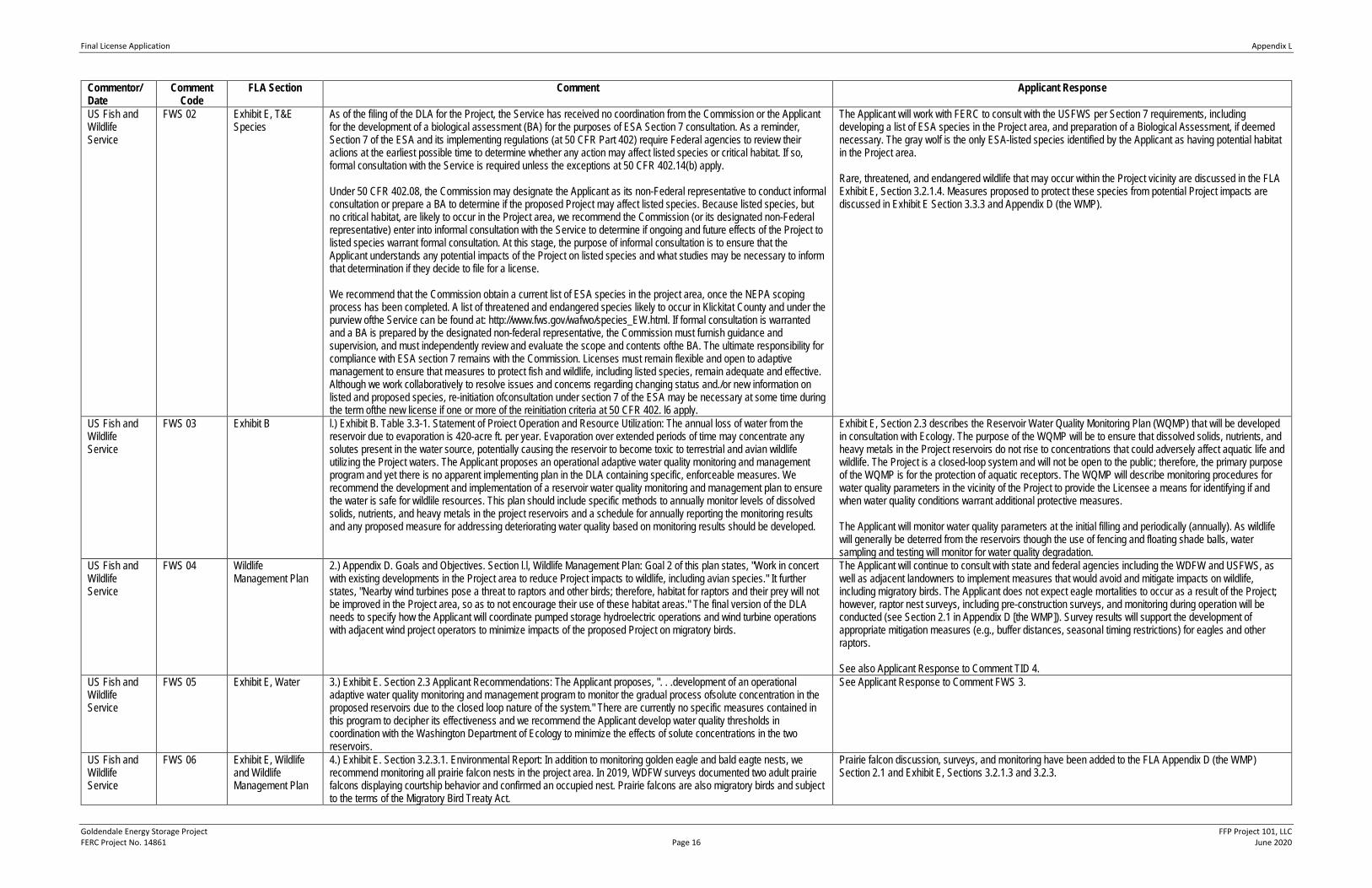
Final License Application Appendix L
Goldendale Energy Storage Project FFP Project 101, LLC FERC Project No. 14861 Page 16 June 2020
Commentor/ Date
Comment Code
FLA Section Comment Applicant Response
US Fish and Wildlife Service
FWS 02 Exhibit E, T&E Species
As of the filing of the DLA for the Project, the Service has received no coordination from the Commission or the Applicant for the development of a biological assessment (BA) for the purposes of ESA Section 7 consultation. As a reminder, Section 7 of the ESA and its implementing regulations (at 50 CFR Part 402) require Federal agencies to review their aclions at the earliest possible time to determine whether any action may affect listed species or critical habitat. If so, formal consultation with the Service is required unless the exceptions at 50 CFR 402.14(b) apply. Under 50 CFR 402.08, the Commission may designate the Applicant as its non-Federal representative to conduct informal consultation or prepare a BA to determine if the proposed Project may affect listed species. Because listed species, but no critical habitat, are likely to occur in the Project area, we recommend the Commission (or its designated non-Federal representative) enter into informal consultation with the Service to determine if ongoing and future effects of the Project to listed species warrant formal consultation. At this stage, the purpose of informal consultation is to ensure that the Applicant understands any potential impacts of the Project on listed species and what studies may be necessary to inform that determination if they decide to file for a license. We recommend that the Commission obtain a current list of ESA species in the project area, once the NEPA scoping process has been completed. A list of threatened and endangered species likely to occur in Klickitat County and under the purview ofthe Service can be found at: http://www.fws.gov/wafwo/species_EW.html. If formal consultation is warranted and a BA is prepared by the designated non-federal representative, the Commission must furnish guidance and supervision, and must independently review and evaluate the scope and contents ofthe BA. The ultimate responsibility for compliance with ESA section 7 remains with the Commission. Licenses must remain flexible and open to adaptive management to ensure that measures to protect fish and wildlife, including listed species, remain adequate and effective. Although we work collaboratively to resolve issues and concems regarding changing status and./or new information on listed and proposed species, re-initiation ofconsultation under section 7 of the ESA may be necessary at some time during the term ofthe new license if one or more of the reinitiation criteria at 50 CFR 402. l6 apply.
The Applicant will work with FERC to consult with the USFWS per Section 7 requirements, including developing a list of ESA species in the Project area, and preparation of a Biological Assessment, if deemed necessary. The gray wolf is the only ESA-listed species identified by the Applicant as having potential habitat in the Project area. Rare, threatened, and endangered wildlife that may occur within the Project vicinity are discussed in the FLA Exhibit E, Section 3.2.1.4. Measures proposed to protect these species from potential Project impacts are discussed in Exhibit E Section 3.3.3 and Appendix D (the WMP).
US Fish and Wildlife Service
FWS 03 Exhibit B l.) Exhibit B. Table 3.3-1. Statement of Proiect Operation and Resource Utilization: The annual loss of water from the reservoir due to evaporation is 420-acre ft. per year. Evaporation over extended periods of time may concentrate any solutes present in the water source, potentially causing the reservoir to become toxic to terrestrial and avian wildlife utilizing the Project waters. The Applicant proposes an operational adaptive water quality monitoring and management program and yet there is no apparent implementing plan in the DLA containing specific, enforceable measures. We recommend the development and implementation of a reservoir water quality monitoring and management plan to ensure the water is safe for wildlile resources. This plan should include specific methods to annually monitor levels of dissolved solids, nutrients, and heavy metals in the project reservoirs and a schedule for annually reporting the monitoring results and any proposed measure for addressing deteriorating water quality based on monitoring results should be developed.
Exhibit E, Section 2.3 describes the Reservoir Water Quality Monitoring Plan (WQMP) that will be developed in consultation with Ecology. The purpose of the WQMP will be to ensure that dissolved solids, nutrients, and heavy metals in the Project reservoirs do not rise to concentrations that could adversely affect aquatic life and wildlife. The Project is a closed-loop system and will not be open to the public; therefore, the primary purpose of the WQMP is for the protection of aquatic receptors. The WQMP will describe monitoring procedures for water quality parameters in the vicinity of the Project to provide the Licensee a means for identifying if and when water quality conditions warrant additional protective measures. The Applicant will monitor water quality parameters at the initial filling and periodically (annually). As wildlife will generally be deterred from the reservoirs though the use of fencing and floating shade balls, water sampling and testing will monitor for water quality degradation.
US Fish and Wildlife Service
FWS 04 Wildlife Management Plan
2.) Appendix D. Goals and Objectives. Section l.l, Wildlife Management Plan: Goal 2 of this plan states, "Work in concert with existing developments in the Project area to reduce Project impacts to wildlife, including avian species." It further states, "Nearby wind turbines pose a threat to raptors and other birds; therefore, habitat for raptors and their prey will not be improved in the Project area, so as to not encourage their use of these habitat areas." The final version of the DLA needs to specify how the Applicant will coordinate pumped storage hydroelectric operations and wind turbine operations with adjacent wind project operators to minimize impacts of the proposed Project on migratory birds.
The Applicant will continue to consult with state and federal agencies including the WDFW and USFWS, as well as adjacent landowners to implement measures that would avoid and mitigate impacts on wildlife, including migratory birds. The Applicant does not expect eagle mortalities to occur as a result of the Project; however, raptor nest surveys, including pre-construction surveys, and monitoring during operation will be conducted (see Section 2.1 in Appendix D [the WMP]). Survey results will support the development of appropriate mitigation measures (e.g., buffer distances, seasonal timing restrictions) for eagles and other raptors. See also Applicant Response to Comment TID 4.
US Fish and Wildlife Service
FWS 05 Exhibit E, Water 3.) Exhibit E. Section 2.3 Applicant Recommendations: The Applicant proposes, ". . .development of an operational adaptive water quality monitoring and management program to monitor the gradual process ofsolute concentration in the proposed reservoirs due to the closed loop nature of the system." There are currently no specific measures contained in this program to decipher its effectiveness and we recommend the Applicant develop water quality thresholds in coordination with the Washington Departrnent of Ecology to minimize the effects of solute concentrations in the two reservoirs.
See Applicant Response to Comment FWS 3.
US Fish and Wildlife Service
FWS 06 Exhibit E, Wildlife and Wildlife Management Plan
4.) Exhibit E. Section 3.2.3.1. Environmental Report: In addition to monitoring golden eagle and bald eagte nests, we recommend monitoring all prairie falcon nests in the project area. In 2019, WDFW surveys documented two adult prairie falcons displaying courtship behavior and confirmed an occupied nest. Prairie falcons are also migratory birds and subject to the terms of the Migratory Bird Treaty Act.
Prairie falcon discussion, surveys, and monitoring have been added to the FLA Appendix D (the WMP) Section 2.1 and Exhibit E, Sections 3.2.1.3 and 3.2.3.
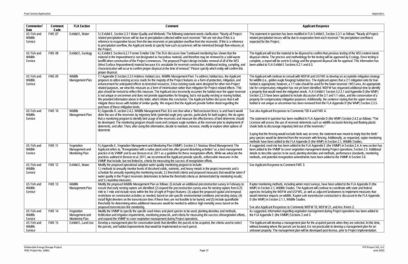
Final License Application Appendix L
Goldendale Energy Storage Project FFP Project 101, LLC FERC Project No. 14861 Page 17 June 2020
Commentor/ Date
Comment Code
FLA Section Comment Applicant Response
US Fish and Wildlife Service
FWS 07 Exhibit E, Water 5.) Exhibit E. Section 2.3.1 Water Quality and Wetlands: The following statement needs clarification: "Nearly all Project-related precipitation losses will be due to precipitation collected within each reservoir." We are not clear if this is a reference to evaporative losses from the two reservoirs or precipitation overflow from the reservoirs. If this is a reference to precipitation overflow, the Applicant needs to specify how such occurrences will be minimized through flow releases at the Project.
The statement in question has been modified in FLA Exhibit E, Section 2.3.1 as follows: "Nearly all Project-related precipitation losses will be due to evaporation from each reservoir." No precipitation overflow is expected for this Project.
US Fish and Wildlife Service
FWS 08 Exhibit E, Geology 6.) Exhibit E Section 6.2.1 Former Smelter Site: The DLA discusses how "continued monitoring has shown that the material in the impoundment is not designated as hazardous material, and therefore may be removed to a solid waste landfill when construction of the Project commences. The proposed Project design includes removal of all of the WSI (West Surface Impoundment) material because it is unsuitable for reservoir construction. Additional testing, sampling, and characterization will occur to confirm proper disposal at the time of removal." Please specify which entity will confirm this proper disposal.
The Applicant will test the material to be disposed to confirm that previous testing of the WSI content meets disposal criteria. The process and methodology for the testing will be approved by Ecology. Once testing is complete, a report will be sent to Ecology and the proposed disposal site for approval. This information has been added to FLA Exhibit E Sections 6.2.1 and 6.3.
US Fish and Wildlife Service
FWS 09 Wildlife Management Plan
7.1 Appendix D Section 2.3.5 Address Habitat Loss. Wildlife Management Plan: To address habitat loss, the Applicant proposes to utilize existing access roads for the majority of the Project features as a form of protection, mitigation, and enhancement for anticipated effects to terrestrial resources. Since existing roads were designed for other non-Project related purposes, we view this measure as a form of minimization rather than mitigation for Project related effects. This plan should be revised to reflect this measure. The Applicant also incorrectly assumes the habitat near the upper reservoir is not unique or uncommon and does not provide opportunities for foraging, but is not quality nesting or rearing habitat. We provided information above in this letter, which refutes this conclusion. The Applicant further discusses that it will mitigate these losses with habitat of similar quality. We request that the Applicant provide further detail regarding the purchase of these mitigation lands.
The Applicant will continue to consult with WDFW and USFWS to develop an acceptable mitigation strategy for wildlife (i.e., golden eagle foraging) habitat loss. The Applicant agrees that a 2:1 mitigation ratio for true habitat is appropriate; however, a 1:1 ratio should be used for the lower reservoir / WSI area. An appropriate site for compensatory mitigation has not yet been identified. WDFW has requested additional time to identify a property that would meet the mitigation needs. FLA Exhibit E Section 3.2.3.1 and Appendix D (the WMP) Section 2.2.5 have been updated to include discussion of the 2:1 and 1:1 ratios, and the conservation of a property for compensatory mitigation purposes. Additionally, the sentence stating that the upper reservoir habitat is not unique or uncommon has been removed from the FLA Appendix D (the WMP) Section 2.3.5.
US Fish and Wildlife Service
FWS 10 Wildlife Management Plan
8.) Appendix D. section 2.4.2. Wildlife Management Plan: It is not clear what a "bird exclusion fence, is and how it would deter the use of the reservoirs by migratory birds (potential eagle prey species, particularly for bald eagles). We do agree that a monitoring program to identify bird usage of the reservoirs and measure the effectiveness of bird deterrents should be developed. The monitoring program should count and compare eagle numbers at the reservoir prior to deployment of deterrents, and after. Then, after using this information, decide to maintain, increase, modify or explore other options of deterrents
See also Applicant Responses to Comments TID 4 and FWS 4. The statement in question has been modified in FLA Appendix D (the WMP) Section 2.4.2 as follows: "The Licensee will assess the use of reservoir deterrents such as wildlife exclusion fencing and floating plastic shade balls to discourage migratory bird use of the reservoirs." Saying that the fencing would exclude birds was an error, the statement was meant to imply that the birds' prey species would be deterred from the reservoirs with fencing. Additionally, as requested, raptor monitoring methods have been added to the FLA Appendix D (the WMP) in Section 2.1, Wildlife Studies.
US Fish and Wildlife Service
FWS 11 Vegetation Management and Monitoring Plan
9.) Appendix E, Vegetation Management and Monitoring Plan VMMP). Section 2.1 Noxious Weed Management: The Applicant refers to, "Revegetation with a native plant seed mix after ground disturbing activities" as a best management practice in its VMMP and to use Benson et al. 2011 as a guideline for these revegetation efforts. While we advocate the practices outlined in Benson et al. 2011, we recommend the Applicant provide specific, enforceable measures in the VMMP that include, but not limited to, criteria for measuring the success of revegelation efforts.
A suggested, seed mix has been added to the FLA Appendix E (the VMMP) in Section 2.4. A new section has been added to the VMMP to cover vegetation management during Project operations, Section 2.5. Additional details to describe species to be used, planting densities and methods, performance standards, monitoring methods, and potential revegetation amendments have been added to the VMMP in Section 3.0.
US Fish and Wildlife Service
FWS 12 Exhibit E, Water Modify the proposed operational adaptive water quality monitoring program to include: 1.) methods to annually monitor levels of dissolved solids, nutrients, and heavy metals in the project reservoirs and a schedule for annually reporting the monitoring results; 2.) threshold criteria and proposed measures that would be taken if water quality in the Project reservoirs deteriorates to below the threshold criteria as demonstrated by monitoring results; and 3.) reporting measures.
See Applicant Response to Comment FWS 3.
US Fish and Wildlife Service
FWS 13 Wildlife Management Plan
Modify the proposed Wildlife Management Plan as follows: (l) include an additional preconstruction survey in February to ensure that early nesting raptors are identified; (2) expand the preconstruction survey area for nesting raptors from 0.25 mile to 1 mile and include nests within the line of sight of Project features; (3) adjust the proposed spatial and temporal restrictions on construction activities as needed, based on site-specific environmental conditions and nesting status; (4) install flight diverters on the transmission lines if these lines are not feasible to be buried; and (5) include quantifiable thresholds for determining when additional measures would be needed to address high mortality areas based on the proposed transmission line monitoring.
Raptor monitoring methods, including winter roost surveys, have been added to the FLA Appendix D (the WMP) in Section 2.1, Wildlife Studies. The Applicant will continue to coordinate with state and federal agencies including the WDFW and USFWS, as well as adjacent landowners to implement measures that would minimize impacts on wildlife. Raptor-safe transmission construction is discussed in the FLA Appendix D (the WMP) in Section 2.1.1, Wildlife Studies. See also Applicant Responses to Comments WDFW 10, WDFW 21, and Am. Rivers 2.
US Fish and Wildlife Service
FWS 14 Vegetation Management and Monitoring Plan
Modify the VMMP to specify the specific seed mixes and plant species to be used; planting densities and methods, fertilization and irrigation requirements, monitoring protocols, and criteria for measuring the success ofrevegetation efforts, and expand the VMMP to cover vegetation management during Project operations.
As suggested, information regarding vegetation management during Project operations has been added to the FLA Appendix E (the VMMP) Sections 2 and 3.
US Fish and Wildlife Service
FWS 15 Exhibit E, Land Use Develop a management plan for conservation lands that identifies the parcels to be acquired, the criteria used to select the parcels, and habitat improvements that would be implemented on each parcel.
The Applicant will develop a management plan for the acquired parcels when they are selected. At this time, without knowing where the parcels are located, it is not practicable to develop a management plan for an unknown property. The management plan will be developed post-license, prior to Project implementation.
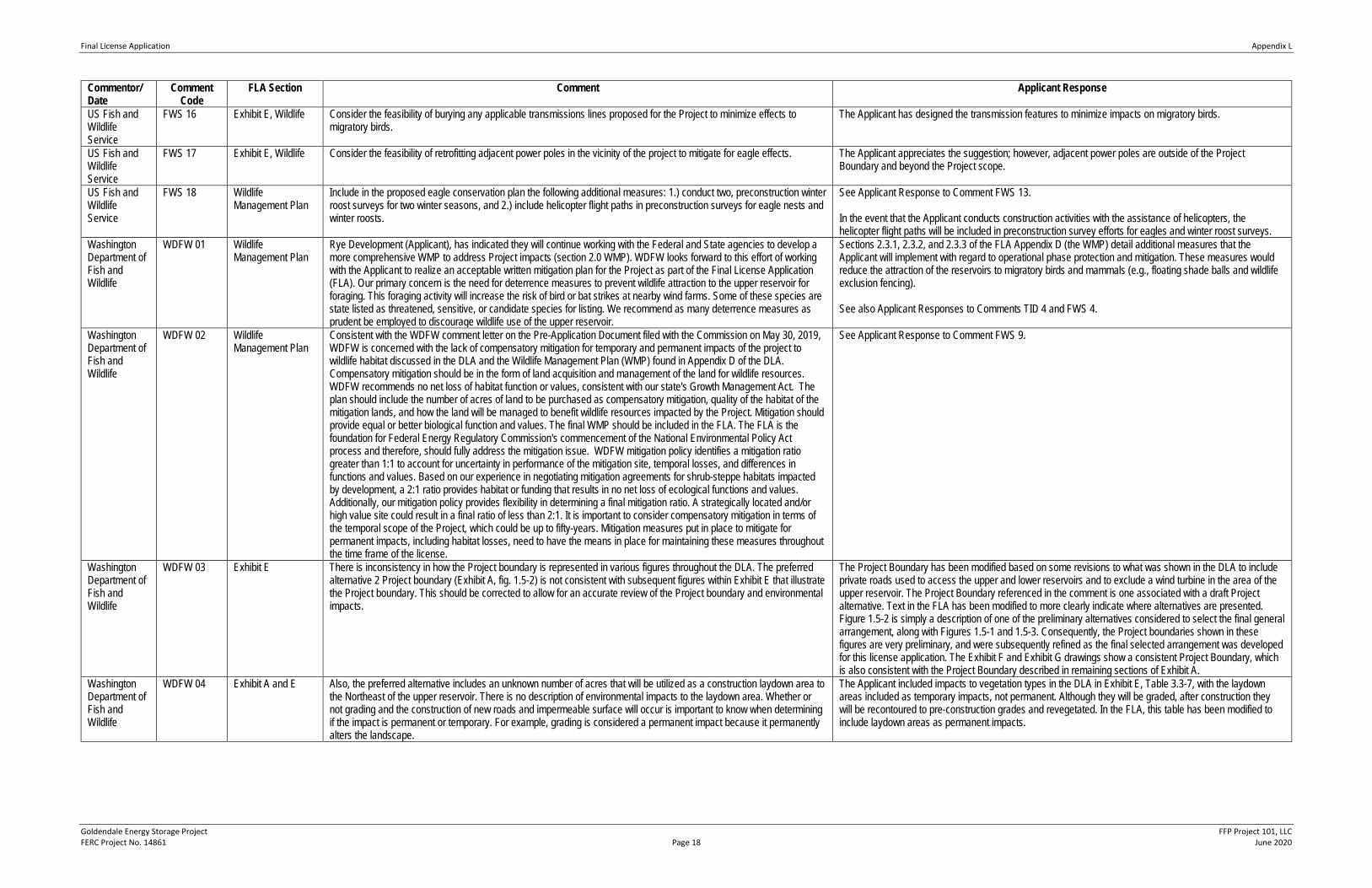
Final License Application Appendix L
Goldendale Energy Storage Project FFP Project 101, LLC FERC Project No. 14861 Page 18 June 2020
Commentor/ Date
Comment Code
FLA Section Comment Applicant Response
US Fish and Wildlife Service
FWS 16 Exhibit E, Wildlife Consider the feasibility of burying any applicable transmissions lines proposed for the Project to minimize effects to migratory birds.
The Applicant has designed the transmission features to minimize impacts on migratory birds.
US Fish and Wildlife Service
FWS 17 Exhibit E, Wildlife Consider the feasibility of retrofitting adjacent power poles in the vicinity of the project to mitigate for eagle effects. The Applicant appreciates the suggestion; however, adjacent power poles are outside of the Project Boundary and beyond the Project scope.
US Fish and Wildlife Service
FWS 18 Wildlife Management Plan
Include in the proposed eagle conservation plan the following additional measures: 1.) conduct two, preconstruction winter roost surveys for two winter seasons, and 2.) include helicopter flight paths in preconstruction surveys for eagle nests and winter roosts.
See Applicant Response to Comment FWS 13. In the event that the Applicant conducts construction activities with the assistance of helicopters, the helicopter flight paths will be included in preconstruction survey efforts for eagles and winter roost surveys.
Washington Department of Fish and Wildlife
WDFW 01 Wildlife Management Plan
Rye Development (Applicant), has indicated they will continue working with the Federal and State agencies to develop a more comprehensive WMP to address Project impacts (section 2.0 WMP). WDFW looks forward to this effort of working with the Applicant to realize an acceptable written mitigation plan for the Project as part of the Final License Application (FLA). Our primary concern is the need for deterrence measures to prevent wildlife attraction to the upper reservoir for foraging. This foraging activity will increase the risk of bird or bat strikes at nearby wind farms. Some of these species are state listed as threatened, sensitive, or candidate species for listing. We recommend as many deterrence measures as prudent be employed to discourage wildlife use of the upper reservoir.
Sections 2.3.1, 2.3.2, and 2.3.3 of the FLA Appendix D (the WMP) detail additional measures that the Applicant will implement with regard to operational phase protection and mitigation. These measures would reduce the attraction of the reservoirs to migratory birds and mammals (e.g., floating shade balls and wildlife exclusion fencing). See also Applicant Responses to Comments TID 4 and FWS 4.
Washington Department of Fish and Wildlife
WDFW 02 Wildlife Management Plan
Consistent with the WDFW comment letter on the Pre-Application Document filed with the Commission on May 30, 2019, WDFW is concerned with the lack of compensatory mitigation for temporary and permanent impacts of the project to wildlife habitat discussed in the DLA and the Wildlife Management Plan (WMP) found in Appendix D of the DLA. Compensatory mitigation should be in the form of land acquisition and management of the land for wildlife resources. WDFW recommends no net loss of habitat function or values, consistent with our state's Growth Management Act. The plan should include the number of acres of land to be purchased as compensatory mitigation, quality of the habitat of the mitigation lands, and how the land will be managed to benefit wildlife resources impacted by the Project. Mitigation should provide equal or better biological function and values. The final WMP should be included in the FLA. The FLA is the foundation for Federal Energy Regulatory Commission's commencement of the National Environmental Policy Act process and therefore, should fully address the mitigation issue. WDFW mitigation policy identifies a mitigation ratio greater than 1:1 to account for uncertainty in performance of the mitigation site, temporal losses, and differences in functions and values. Based on our experience in negotiating mitigation agreements for shrub-steppe habitats impacted by development, a 2:1 ratio provides habitat or funding that results in no net loss of ecological functions and values. Additionally, our mitigation policy provides flexibility in determining a final mitigation ratio. A strategically located and/or high value site could result in a final ratio of less than 2:1. It is important to consider compensatory mitigation in terms of the temporal scope of the Project, which could be up to fifty-years. Mitigation measures put in place to mitigate for permanent impacts, including habitat losses, need to have the means in place for maintaining these measures throughout the time frame of the license.
See Applicant Response to Comment FWS 9.
Washington Department of Fish and Wildlife
WDFW 03 Exhibit E There is inconsistency in how the Project boundary is represented in various figures throughout the DLA. The preferred alternative 2 Project boundary (Exhibit A, fig. 1.5-2) is not consistent with subsequent figures within Exhibit E that illustrate the Project boundary. This should be corrected to allow for an accurate review of the Project boundary and environmental impacts.
The Project Boundary has been modified based on some revisions to what was shown in the DLA to include private roads used to access the upper and lower reservoirs and to exclude a wind turbine in the area of the upper reservoir. The Project Boundary referenced in the comment is one associated with a draft Project alternative. Text in the FLA has been modified to more clearly indicate where alternatives are presented. Figure 1.5-2 is simply a description of one of the preliminary alternatives considered to select the final general arrangement, along with Figures 1.5-1 and 1.5-3. Consequently, the Project boundaries shown in these figures are very preliminary, and were subsequently refined as the final selected arrangement was developed for this license application. The Exhibit F and Exhibit G drawings show a consistent Project Boundary, which is also consistent with the Project Boundary described in remaining sections of Exhibit A.
Washington Department of Fish and Wildlife
WDFW 04 Exhibit A and E Also, the preferred alternative includes an unknown number of acres that will be utilized as a construction laydown area to the Northeast of the upper reservoir. There is no description of environmental impacts to the laydown area. Whether or not grading and the construction of new roads and impermeable surface will occur is important to know when determining if the impact is permanent or temporary. For example, grading is considered a permanent impact because it permanently alters the landscape.
The Applicant included impacts to vegetation types in the DLA in Exhibit E, Table 3.3-7, with the laydown areas included as temporary impacts, not permanent. Although they will be graded, after construction they will be recontoured to pre-construction grades and revegetated. In the FLA, this table has been modified to include laydown areas as permanent impacts.
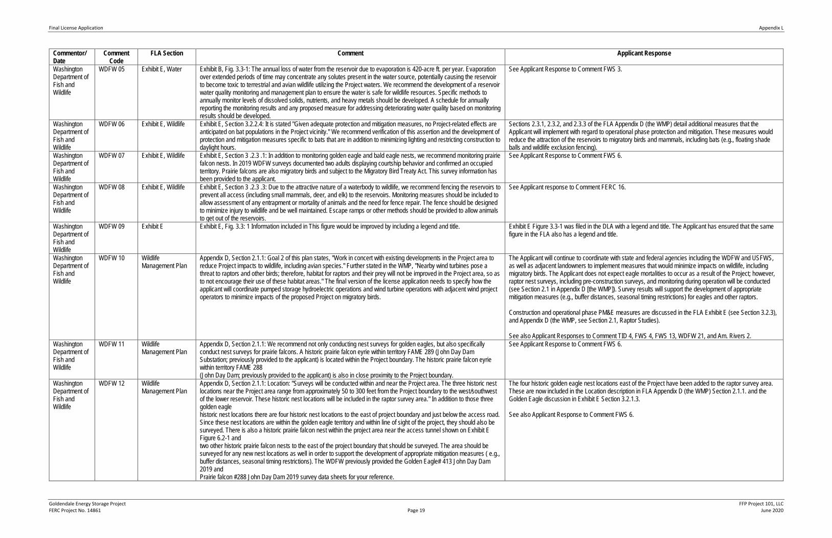
Final License Application Appendix L
Goldendale Energy Storage Project FFP Project 101, LLC FERC Project No. 14861 Page 19 June 2020
Commentor/ Date
Comment Code
FLA Section Comment Applicant Response
Washington Department of Fish and Wildlife
WDFW 05 Exhibit E, Water Exhibit B, Fig. 3.3-1: The annual loss of water from the reservoir due to evaporation is 420-acre ft. per year. Evaporation over extended periods of time may concentrate any solutes present in the water source, potentially causing the reservoir to become toxic to terrestrial and avian wildlife utilizing the Project waters. We recommend the development of a reservoir water quality monitoring and management plan to ensure the water is safe for wildlife resources. Specific methods to annually monitor levels of dissolved solids, nutrients, and heavy metals should be developed. A schedule for annually reporting the monitoring results and any proposed measure for addressing deteriorating water quality based on monitoring results should be developed.
See Applicant Response to Comment FWS 3.
Washington Department of Fish and Wildlife
WDFW 06 Exhibit E, Wildlife Exhibit E, Section 3.2.2.4: It is stated "Given adequate protection and mitigation measures, no Project-related effects are anticipated on bat populations in the Project vicinity." We recommend verification of this assertion and the development of protection and mitigation measures specific to bats that are in addition to minimizing lighting and restricting construction to daylight hours.
Sections 2.3.1, 2.3.2, and 2.3.3 of the FLA Appendix D (the WMP) detail additional measures that the Applicant will implement with regard to operational phase protection and mitigation. These measures would reduce the attraction of the reservoirs to migratory birds and mammals, including bats (e.g., floating shade balls and wildlife exclusion fencing).
Washington Department of Fish and Wildlife
WDFW 07 Exhibit E, Wildlife Exhibit E, Section 3 .2.3 .1: In addition to monitoring golden eagle and bald eagle nests, we recommend monitoring prairie falcon nests. In 2019 WDFW surveys documented two adults displaying courtship behavior and confirmed an occupied territory. Prairie falcons are also migratory birds and subject to the Migratory Bird Treaty Act. This survey information has been provided to the applicant.
See Applicant Response to Comment FWS 6.
Washington Department of Fish and Wildlife
WDFW 08 Exhibit E, Wildlife Exhibit E, Section 3 .2.3 .3: Due to the attractive nature of a waterbody to wildlife, we recommend fencing the reservoirs to prevent all access (including small mammals, deer, and elk) to the reservoirs. Monitoring measures should be included to allow assessment of any entrapment or mortality of animals and the need for fence repair. The fence should be designed to minimize injury to wildlife and be well maintained. Escape ramps or other methods should be provided to allow animals to get out of the reservoirs.
See Applicant response to Comment FERC 16.
Washington Department of Fish and Wildlife
WDFW 09 Exhibit E Exhibit E, Fig. 3.3: 1 Information included in This figure would be improved by including a legend and title. Exhibit E Figure 3.3-1 was filed in the DLA with a legend and title. The Applicant has ensured that the same figure in the FLA also has a legend and title.
Washington Department of Fish and Wildlife
WDFW 10 Wildlife Management Plan
Appendix D, Section 2.1.1: Goal 2 of this plan states, "Work in concert with existing developments in the Project area to reduce Project impacts to wildlife, including avian species." Further stated in the WMP, "Nearby wind turbines pose a threat to raptors and other birds; therefore, habitat for raptors and their prey will not be improved in the Project area, so as to not encourage their use of these habitat areas." The final version of the license application needs to specify how the applicant will coordinate pumped storage hydroelectric operations and wind turbine operations with adjacent wind project operators to minimize impacts of the proposed Project on migratory birds.
The Applicant will continue to coordinate with state and federal agencies including the WDFW and USFWS, as well as adjacent landowners to implement measures that would minimize impacts on wildlife, including migratory birds. The Applicant does not expect eagle mortalities to occur as a result of the Project; however, raptor nest surveys, including pre-construction surveys, and monitoring during operation will be conducted (see Section 2.1 in Appendix D [the WMP]). Survey results will support the development of appropriate mitigation measures (e.g., buffer distances, seasonal timing restrictions) for eagles and other raptors. Construction and operational phase PM&E measures are discussed in the FLA Exhibit E (see Section 3.2.3), and Appendix D (the WMP, see Section 2.1, Raptor Studies). See also Applicant Responses to Comment TID 4, FWS 4, FWS 13, WDFW 21, and Am. Rivers 2.
Washington Department of Fish and Wildlife
WDFW 11 Wildlife Management Plan
Appendix D, Section 2.1.1: We recommend not only conducting nest surveys for golden eagles, but also specifically conduct nest surveys for prairie falcons. A historic prairie falcon eyrie within territory FAME 289 (John Day Dam Substation; previously provided to the applicant) is located within the Project boundary. The historic prairie falcon eyrie within territory FAME 288 (John Day Dam; previously provided to the applicant) is also in close proximity to the Project boundary.
See Applicant Response to Comment FWS 6.
Washington Department of Fish and Wildlife
WDFW 12 Wildlife Management Plan
Appendix D, Section 2.1.1: Location: "Surveys will be conducted within and near the Project area. The three historic nest locations near the Project area range from approximately 50 to 300 feet from the Project boundary to the west/southwest of the lower reservoir. These historic nest locations will be included in the raptor survey area." In addition to those three golden eagle historic nest locations there are four historic nest locations to the east of project boundary and just below the access road. Since these nest locations are within the golden eagle territory and within line of sight of the project, they should also be surveyed. There is also a historic prairie falcon nest within the project area near the access tunnel shown on Exhibit E Figure 6.2-1 and two other historic prairie falcon nests to the east of the project boundary that should be surveyed. The area should be surveyed for any new nest locations as well in order to support the development of appropriate mitigation measures ( e.g., buffer distances, seasonal timing restrictions). The WDFW previously provided the Golden Eagle# 413 John Day Dam 2019 and Prairie falcon #288 John Day Dam 2019 survey data sheets for your reference.
The four historic golden eagle nest locations east of the Project have been added to the raptor survey area. These are now included in the Location description in FLA Appendix D (the WMP) Section 2.1.1. and the Golden Eagle discussion in Exhibit E Section 3.2.1.3. See also Applicant Response to Comment FWS 6.
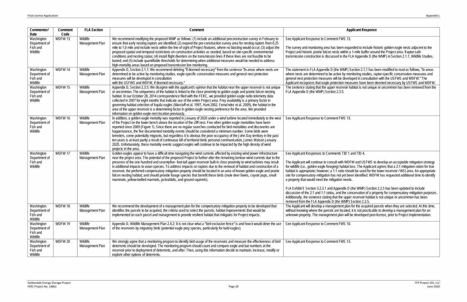
Final License Application Appendix L
Goldendale Energy Storage Project FFP Project 101, LLC FERC Project No. 14861 Page 20 June 2020
Commentor/ Date
Comment Code
FLA Section Comment Applicant Response
Washington Department of Fish and Wildlife
WDFW 13 Wildlife Management Plan
We recommend modifying the proposed WMP as follows: (1) include an additional preconstruction survey in February to ensure that early nesting raptors are identified; (2) expand the pre-construction survey area for nesting raptors from 0.25 mile to 1.0 mile and include nests within the line of sight of Project features, where no blasting would occur; (3) adjust the proposed spatial and temporal restrictions on construction activities as needed, based on site-specific environmental conditions and nesting status; (4) install flight diverters on the transmission lines if these lines are not feasible to be buried; and (5) include quantifiable thresholds for determining when additional measures would be needed to address high-mortality areas based on proposed transmission line monitoring.
See Applicant Response to Comment FWS 13. The survey and monitoring area has been expanded to include historic golden eagle nests adjacent to the Project and historic prairie falcon nests within a 1-mile buffer around the Project area. Raptor-safe transmission construction is discussed in the FLA Appendix D (the WMP) in Section 2.1.1, Wildlife Studies.
Washington Department of Fish and Wildlife
WDFW 14 Wildlife Management Plan
Appendix D, Section 2.1.1: We recommend deleting "if deemed necessary" from the sentence "In areas where nests are determined to be active by monitoring studies, eagle-specific conservation measures and general nest protection measures will be developed in consultation with the USFWS and WDFW, if deemed necessary."
The statement in FLA Appendix D (the WMP) Section 2.1.1 has been modified to read as follows, "In areas where nests are determined to be active by monitoring studies, raptor-specific conservation measures and general nest protection measures will be developed in consultation with the USFWS and WDFW." The Applicant recognizes that eagle protection measures have been deemed necessary by USFWS and WDFW.
Washington Department of Fish and Wildlife
WDFW 15 Wildlife Management Plan
Appendix D, Section 2.3.5: We disagree with the applicant's opinion that the habitat near the upper reservoir is not unique or uncommon. The uniqueness of the habitat is linked to the close proximity to golden eagle and prairie falcon nesting habitat. In our October 28, 2014 correspondence filed with the FERC, we provided golden eagle radio telemetry data collected in 2007 for eight months that indicate use of the entire Project area. Prey availability is a primary factor in governing habitat selection of Aquila eagles (Marzluff et al. 1997, Hunt 2002, Fema'ndez et al. 2009), the habitat in the area of the upper reservoir is a determining factor in golden eagle nesting preference for the area. We provided information on golden eagle nest location previously.
The sentence stating that the upper reservoir habitat is not unique or uncommon has been removed from the FLA Appendix D (the WMP) Section 2.3.5.
Washington Department of Fish and Wildlife
WDFW 16 Wildlife Management Plan
In addition, a golden eagle mortality was reported in January of 2020 under a wind turbine located immediately to the west of the Project on the lower bench above the location of the cliff nest. Five other golden eagle mortalities have been reported since 2009 (Figure 1). Since there are no regular searches conducted for bird mortalities and discoveries are happenstance, the five documented mortality events should be considered a minimum number. Some birds were breeders, some potentially migrants, but regardless it is obvious the poor occupancy of the John Day territory in the past ten years is at least partly a result of continuous kill of territorial birds personal communication, James Watson January 2020. Unfortunately, these mortality events suggest eagles will continue to be impacted by the high density of wind projects in the area.
See Applicant Response to Comment FWS 13.
Washington Department of Fish and Wildlife
WDFW 17 Wildlife Management Plan
Golden eagles appear to have a difficult time navigating the wind currents affected by existing wind power infrastructure near the project area. The potential of the proposed Project to further alter the remaining laminar wind currents due to the presence of the one hundred and seventyfive- foot-tall upper reservoir built in close proximity to wind turbines may result in additional impacts to avian species. To address impacts on raptors due to the removal of habitat and construction of a reservoir, the preferred compensatory mitigation property should be located in an area of known golden eagle and prairie falcon nesting habitat; and should provide forage species that benefit these birds (mule deer fawns, coyote pups, small mammals, yellow-bellied marmots, jackrabbits, and ground squirrels).
See Applicant Responses to Comments TID 1 and TID 4. The Applicant will continue to consult with WDFW and USFWS to develop an acceptable mitigation strategy for wildlife (i.e., golden eagle foraging) habitat loss. The Applicant agrees that a 2:1 mitigation ration for true habitat is appropriate; however, a 1:1 ratio should be used for the lower reservoir / WSI area. An appropriate site for compensatory mitigation has not yet been identified. WDFW has requested additional time to identify a property that would meet the mitigation needs. FLA Exhibit E Section 3.2.3.1 and Appendix D (the WMP) Section 2.2.5 has been updated to include discussion of the 2:1 and 1:1 ratios, and the conservation of a property for compensatory mitigation purposes. Additionally, the sentence stating that the upper reservoir habitat is not unique or uncommon has been removed from the FLA Appendix D (the WMP) Section 2.3.5.
Washington Department of Fish and Wildlife
WDFW 18 Wildlife Management Plan
We recommend the development of a management plan for the compensatory mitigation property to be developed that identifies the parcels to be acquired, the criteria used to select the parcels, habitat improvements that would be implemented on each parcel and management to provide resilient habitat that mitigates for Project impacts.
The Applicant will develop a management plan for the acquired parcels when they are selected. At this time, without knowing where the parcels are located, it is not practicable to develop a management plan for an unknown property. The management plan will be developed post-license, prior to Project implementation.
Washington Department of Fish and Wildlife
WDFW 19 Wildlife Management Plan
Appendix D, Wildlife Management Plan 2.4.2: It is not clear what a ''bird exclusion fence" is and how it would deter the use of the reservoirs by migratory birds (potential eagle prey species, particularly for bald eagles).
See Applicant Response to Comment FWS 10.
Washington Department of Fish and Wildlife
WDFW 20 Wildlife Management Plan
We strongly agree that a monitoring program to identify bird usage of the reservoirs and measure the effectiveness of bird deterrents should be developed. The monitoring program should count and compare eagle and bat numbers at the reservoir prior to deployment of deterrents, and after. Then, using this information decide to maintain, increase, modify or explore other options of deterrents.
See Applicant Response to Comment FWS 13.
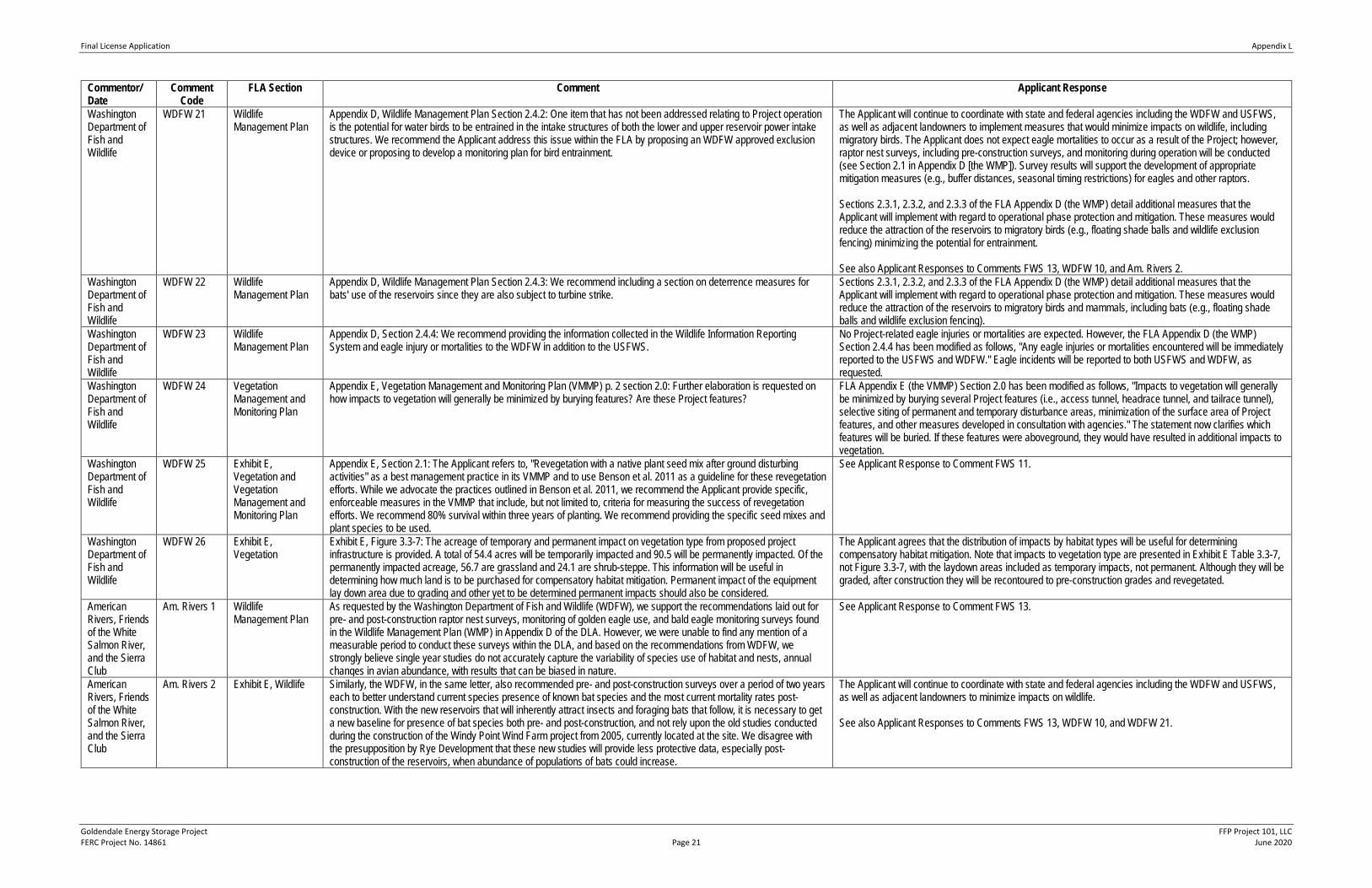
Final License Application Appendix L
Goldendale Energy Storage Project FFP Project 101, LLC FERC Project No. 14861 Page 21 June 2020
Commentor/ Date
Comment Code
FLA Section Comment Applicant Response
Washington Department of Fish and Wildlife
WDFW 21 Wildlife Management Plan
Appendix D, Wildlife Management Plan Section 2.4.2: One item that has not been addressed relating to Project operation is the potential for water birds to be entrained in the intake structures of both the lower and upper reservoir power intake structures. We recommend the Applicant address this issue within the FLA by proposing an WDFW approved exclusion device or proposing to develop a monitoring plan for bird entrainment.
The Applicant will continue to coordinate with state and federal agencies including the WDFW and USFWS, as well as adjacent landowners to implement measures that would minimize impacts on wildlife, including migratory birds. The Applicant does not expect eagle mortalities to occur as a result of the Project; however, raptor nest surveys, including pre-construction surveys, and monitoring during operation will be conducted (see Section 2.1 in Appendix D [the WMP]). Survey results will support the development of appropriate mitigation measures (e.g., buffer distances, seasonal timing restrictions) for eagles and other raptors. Sections 2.3.1, 2.3.2, and 2.3.3 of the FLA Appendix D (the WMP) detail additional measures that the Applicant will implement with regard to operational phase protection and mitigation. These measures would reduce the attraction of the reservoirs to migratory birds (e.g., floating shade balls and wildlife exclusion fencing) minimizing the potential for entrainment. See also Applicant Responses to Comments FWS 13, WDFW 10, and Am. Rivers 2.
Washington Department of Fish and Wildlife
WDFW 22 Wildlife Management Plan
Appendix D, Wildlife Management Plan Section 2.4.3: We recommend including a section on deterrence measures for bats' use of the reservoirs since they are also subject to turbine strike.
Sections 2.3.1, 2.3.2, and 2.3.3 of the FLA Appendix D (the WMP) detail additional measures that the Applicant will implement with regard to operational phase protection and mitigation. These measures would reduce the attraction of the reservoirs to migratory birds and mammals, including bats (e.g., floating shade balls and wildlife exclusion fencing).
Washington Department of Fish and Wildlife
WDFW 23 Wildlife Management Plan
Appendix D, Section 2.4.4: We recommend providing the information collected in the Wildlife Information Reporting System and eagle injury or mortalities to the WDFW in addition to the USFWS.
No Project-related eagle injuries or mortalities are expected. However, the FLA Appendix D (the WMP) Section 2.4.4 has been modified as follows, "Any eagle injuries or mortalities encountered will be immediately reported to the USFWS and WDFW." Eagle incidents will be reported to both USFWS and WDFW, as requested.
Washington Department of Fish and Wildlife
WDFW 24 Vegetation Management and Monitoring Plan
Appendix E, Vegetation Management and Monitoring Plan (VMMP) p. 2 section 2.0: Further elaboration is requested on how impacts to vegetation will generally be minimized by burying features? Are these Project features?
FLA Appendix E (the VMMP) Section 2.0 has been modified as follows, "Impacts to vegetation will generally be minimized by burying several Project features (i.e., access tunnel, headrace tunnel, and tailrace tunnel), selective siting of permanent and temporary disturbance areas, minimization of the surface area of Project features, and other measures developed in consultation with agencies." The statement now clarifies which features will be buried. If these features were aboveground, they would have resulted in additional impacts to vegetation.
Washington Department of Fish and Wildlife
WDFW 25 Exhibit E, Vegetation and Vegetation Management and Monitoring Plan
Appendix E, Section 2.1: The Applicant refers to, "Revegetation with a native plant seed mix after ground disturbing activities" as a best management practice in its VMMP and to use Benson et al. 2011 as a guideline for these revegetation efforts. While we advocate the practices outlined in Benson et al. 2011, we recommend the Applicant provide specific, enforceable measures in the VMMP that include, but not limited to, criteria for measuring the success of revegetation efforts. We recommend 80% survival within three years of planting. We recommend providing the specific seed mixes and plant species to be used.
See Applicant Response to Comment FWS 11.
Washington Department of Fish and Wildlife
WDFW 26 Exhibit E, Vegetation
Exhibit E, Figure 3.3-7: The acreage of temporary and permanent impact on vegetation type from proposed project infrastructure is provided. A total of 54.4 acres will be temporarily impacted and 90.5 will be permanently impacted. Of the permanently impacted acreage, 56.7 are grassland and 24.1 are shrub-steppe. This information will be useful in determining how much land is to be purchased for compensatory habitat mitigation. Permanent impact of the equipment lay down area due to grading and other yet to be determined permanent impacts should also be considered.
The Applicant agrees that the distribution of impacts by habitat types will be useful for determining compensatory habitat mitigation. Note that impacts to vegetation type are presented in Exhibit E Table 3.3-7, not Figure 3.3-7, with the laydown areas included as temporary impacts, not permanent. Although they will be graded, after construction they will be recontoured to pre-construction grades and revegetated.
American Rivers, Friends of the White Salmon River, and the Sierra Club
Am. Rivers 1 Wildlife Management Plan
As requested by the Washington Department of Fish and Wildlife (WDFW), we support the recommendations laid out for pre- and post-construction raptor nest surveys, monitoring of golden eagle use, and bald eagle monitoring surveys found in the Wildlife Management Plan (WMP) in Appendix D of the DLA. However, we were unable to find any mention of a measurable period to conduct these surveys within the DLA, and based on the recommendations from WDFW, we strongly believe single year studies do not accurately capture the variability of species use of habitat and nests, annual changes in avian abundance, with results that can be biased in nature.
See Applicant Response to Comment FWS 13.
American Rivers, Friends of the White Salmon River, and the Sierra Club
Am. Rivers 2 Exhibit E, Wildlife Similarly, the WDFW, in the same letter, also recommended pre- and post-construction surveys over a period of two years each to better understand current species presence of known bat species and the most current mortality rates post-construction. With the new reservoirs that will inherently attract insects and foraging bats that follow, it is necessary to get a new baseline for presence of bat species both pre- and post-construction, and not rely upon the old studies conducted during the construction of the Windy Point Wind Farm project from 2005, currently located at the site. We disagree with the presupposition by Rye Development that these new studies will provide less protective data, especially post-construction of the reservoirs, when abundance of populations of bats could increase.
The Applicant will continue to coordinate with state and federal agencies including the WDFW and USFWS, as well as adjacent landowners to minimize impacts on wildlife. See also Applicant Responses to Comments FWS 13, WDFW 10, and WDFW 21.
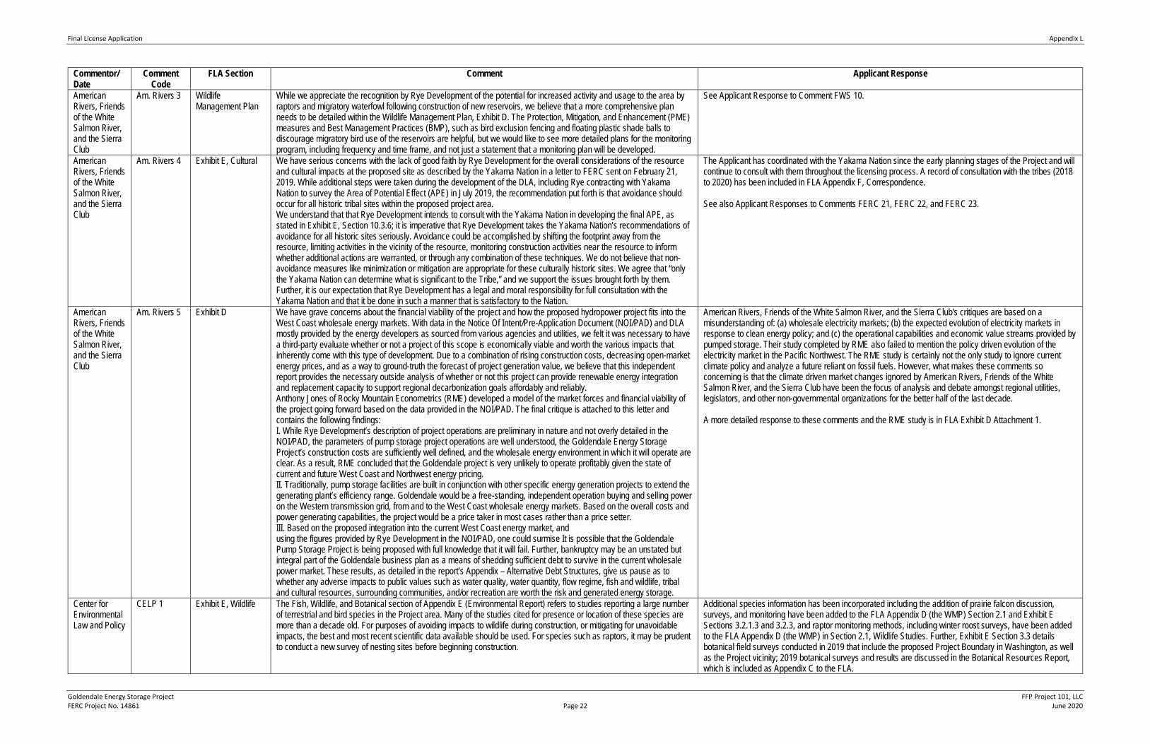
Final License Application Appendix L
Goldendale Energy Storage Project FFP Project 101, LLC FERC Project No. 14861 Page 22 June 2020
Commentor/ Date
Comment Code
FLA Section Comment Applicant Response
American Rivers, Friends of the White Salmon River, and the Sierra Club
Am. Rivers 3 Wildlife Management Plan
While we appreciate the recognition by Rye Development of the potential for increased activity and usage to the area by raptors and migratory waterfowl following construction of new reservoirs, we believe that a more comprehensive plan needs to be detailed within the Wildlife Management Plan, Exhibit D. The Protection, Mitigation, and Enhancement (PME) measures and Best Management Practices (BMP), such as bird exclusion fencing and floating plastic shade balls to discourage migratory bird use of the reservoirs are helpful, but we would like to see more detailed plans for the monitoring program, including frequency and time frame, and not just a statement that a monitoring plan will be developed.
See Applicant Response to Comment FWS 10.
American Rivers, Friends of the White Salmon River, and the Sierra Club
Am. Rivers 4 Exhibit E, Cultural We have serious concerns with the lack of good faith by Rye Development for the overall considerations of the resource and cultural impacts at the proposed site as described by the Yakama Nation in a letter to FERC sent on February 21, 2019. While additional steps were taken during the development of the DLA, including Rye contracting with Yakama Nation to survey the Area of Potential Effect (APE) in July 2019, the recommendation put forth is that avoidance should occur for all historic tribal sites within the proposed project area. We understand that that Rye Development intends to consult with the Yakama Nation in developing the final APE, as stated in Exhibit E, Section 10.3.6; it is imperative that Rye Development takes the Yakama Nation’s recommendations of avoidance for all historic sites seriously. Avoidance could be accomplished by shifting the footprint away from the resource, limiting activities in the vicinity of the resource, monitoring construction activities near the resource to inform whether additional actions are warranted, or through any combination of these techniques. We do not believe that non-avoidance measures like minimization or mitigation are appropriate for these culturally historic sites. We agree that “only the Yakama Nation can determine what is significant to the Tribe,” and we support the issues brought forth by them. Further, it is our expectation that Rye Development has a legal and moral responsibility for full consultation with the Yakama Nation and that it be done in such a manner that is satisfactory to the Nation.
The Applicant has coordinated with the Yakama Nation since the early planning stages of the Project and will continue to consult with them throughout the licensing process. A record of consultation with the tribes (2018 to 2020) has been included in FLA Appendix F, Correspondence. See also Applicant Responses to Comments FERC 21, FERC 22, and FERC 23.
American Rivers, Friends of the White Salmon River, and the Sierra Club
Am. Rivers 5 Exhibit D We have grave concerns about the financial viability of the project and how the proposed hydropower project fits into the West Coast wholesale energy markets. With data in the Notice Of Intent/Pre-Application Document (NOI/PAD) and DLA mostly provided by the energy developers as sourced from various agencies and utilities, we felt it was necessary to have a third-party evaluate whether or not a project of this scope is economically viable and worth the various impacts that inherently come with this type of development. Due to a combination of rising construction costs, decreasing open-market energy prices, and as a way to ground-truth the forecast of project generation value, we believe that this independent report provides the necessary outside analysis of whether or not this project can provide renewable energy integration and replacement capacity to support regional decarbonization goals affordably and reliably. Anthony Jones of Rocky Mountain Econometrics (RME) developed a model of the market forces and financial viability of the project going forward based on the data provided in the NOI/PAD. The final critique is attached to this letter and contains the following findings: I. While Rye Development’s description of project operations are preliminary in nature and not overly detailed in the NOI/PAD, the parameters of pump storage project operations are well understood, the Goldendale Energy Storage Project’s construction costs are sufficiently well defined, and the wholesale energy environment in which it will operate are clear. As a result, RME concluded that the Goldendale project is very unlikely to operate profitably given the state of current and future West Coast and Northwest energy pricing. II. Traditionally, pump storage facilities are built in conjunction with other specific energy generation projects to extend the generating plant’s efficiency range. Goldendale would be a free-standing, independent operation buying and selling power on the Western transmission grid, from and to the West Coast wholesale energy markets. Based on the overall costs and power generating capabilities, the project would be a price taker in most cases rather than a price setter. III. Based on the proposed integration into the current West Coast energy market, and using the figures provided by Rye Development in the NOI/PAD, one could surmise It is possible that the Goldendale Pump Storage Project is being proposed with full knowledge that it will fail. Further, bankruptcy may be an unstated but integral part of the Goldendale business plan as a means of shedding sufficient debt to survive in the current wholesale power market. These results, as detailed in the report’s Appendix – Alternative Debt Structures, give us pause as to whether any adverse impacts to public values such as water quality, water quantity, flow regime, fish and wildlife, tribal and cultural resources, surrounding communities, and/or recreation are worth the risk and generated energy storage.
American Rivers, Friends of the White Salmon River, and the Sierra Club's critiques are based on a misunderstanding of: (a) wholesale electricity markets; (b) the expected evolution of electricity markets in response to clean energy policy; and (c) the operational capabilities and economic value streams provided by pumped storage. Their study completed by RME also failed to mention the policy driven evolution of the electricity market in the Pacific Northwest. The RME study is certainly not the only study to ignore current climate policy and analyze a future reliant on fossil fuels. However, what makes these comments so concerning is that the climate driven market changes ignored by American Rivers, Friends of the White Salmon River, and the Sierra Club have been the focus of analysis and debate amongst regional utilities, legislators, and other non-governmental organizations for the better half of the last decade. A more detailed response to these comments and the RME study is in FLA Exhibit D Attachment 1.
Center for Environmental Law and Policy
CELP 1 Exhibit E, Wildlife The Fish, Wildlife, and Botanical section of Appendix E (Environmental Report) refers to studies reporting a large number of terrestrial and bird species in the Project area. Many of the studies cited for presence or location of these species are more than a decade old. For purposes of avoiding impacts to wildlife during construction, or mitigating for unavoidable impacts, the best and most recent scientific data available should be used. For species such as raptors, it may be prudent to conduct a new survey of nesting sites before beginning construction.
Additional species information has been incorporated including the addition of prairie falcon discussion, surveys, and monitoring have been added to the FLA Appendix D (the WMP) Section 2.1 and Exhibit E Sections 3.2.1.3 and 3.2.3, and raptor monitoring methods, including winter roost surveys, have been added to the FLA Appendix D (the WMP) in Section 2.1, Wildlife Studies. Further, Exhibit E Section 3.3 details botanical field surveys conducted in 2019 that include the proposed Project Boundary in Washington, as well as the Project vicinity; 2019 botanical surveys and results are discussed in the Botanical Resources Report, which is included as Appendix C to the FLA.
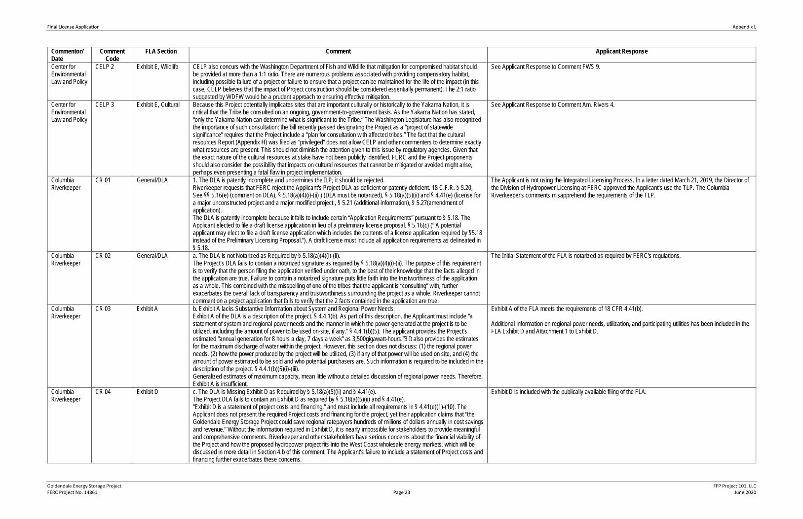
Final License Application Appendix L
Goldendale Energy Storage Project FFP Project 101, LLC FERC Project No. 14861 Page 23 June 2020
Commentor/ Date
Comment Code
FLA Section Comment Applicant Response
Center for Environmental Law and Policy
CELP 2 Exhibit E, Wildlife CELP also concurs with the Washington Department of Fish and Wildlife that mitigation for compromised habitat should be provided at more than a 1:1 ratio. There are numerous problems associated with providing compensatory habitat, including possible failure of a project or failure to ensure that a project can be maintained for the life of the impact (in this case, CELP believes that the impact of Project construction should be considered essentially permanent). The 2:1 ratio suggested by WDFW would be a prudent approach to ensuring effective mitigation.
See Applicant Response to Comment FWS 9.
Center for Environmental Law and Policy
CELP 3 Exhibit E, Cultural Because this Project potentially implicates sites that are important culturally or historically to the Yakama Nation, it is critical that the Tribe be consulted on an ongoing, government-to-government basis. As the Yakama Nation has stated, “only the Yakama Nation can determine what is significant to the Tribe.” The Washington Legislature has also recognized the importance of such consultation; the bill recently passed designating the Project as a “project of statewide significance” requires that the Project include a “plan for consultation with affected tribes.” The fact that the cultural resources Report (Appendix H) was filed as “privileged” does not allow CELP and other commenters to determine exactly what resources are present. This should not diminish the attention given to this issue by regulatory agencies. Given that the exact nature of the cultural resources at stake have not been publicly identified, FERC and the Project proponents should also consider the possibility that impacts on cultural resources that cannot be mitigated or avoided might arise, perhaps even presenting a fatal flaw in project implementation.
See Applicant Response to Comment Am. Rivers 4.
Columbia Riverkeeper
CR 01 General/DLA 1. The DLA is patently incomplete and undermines the ILP; it should be rejected. Riverkeeper requests that FERC reject the Applicant's Project DLA as deficient or patently deficient. 18 C.F.R. § 5.20, See §§ 5.16(e) (comment on DLA), § 5.18(a)(4)(i)-(ii) ) (DLA must be notarized), § 5.18(a)(5)(ii) and § 4.41(e) (license for a major unconstructed project and a major modified project , § 5.21 (additional information), § 5.27(amendment of application). The DLA is patently incomplete because it fails to include certain “Application Requirements” pursuant to § 5.18. The Applicant elected to file a draft license application in lieu of a preliminary license proposal. § 5.16(c) (“ A potential applicant may elect to file a draft license application which includes the contents of a license application required by §5.18 instead of the Preliminary Licensing Proposal.”). A draft license must include all application requirements as delineated in § 5.18.
The Applicant is not using the Integrated Licensing Process. In a letter dated March 21, 2019, the Director of the Division of Hydropower Licensing at FERC approved the Applicant’s use the TLP. The Columbia Riverkeeper's comments misapprehend the requirements of the TLP.
Columbia Riverkeeper
CR 02 General/DLA a. The DLA is not Notarized as Required by § 5.18(a)(4)(i)-(ii). The Project’s DLA fails to contain a notarized signature as required by § 5.18(a)(4)(i)-(ii). The purpose of this requirement is to verify that the person filing the application verified under oath, to the best of their knowledge that the facts alleged in the application are true. Failure to contain a notarized signature puts little faith into the trustworthiness of the application as a whole. This combined with the misspelling of one of the tribes that the applicant is “consulting” with, further exacerbates the overall lack of transparency and trustworthiness surrounding the project as a whole. Riverkeeper cannot comment on a project application that fails to verify that the 2 facts contained in the application are true.
The Initial Statement of the FLA is notarized as required by FERC's regulations.
Columbia Riverkeeper
CR 03 Exhibit A b. Exhibit A lacks Substantive Information about System and Regional Power Needs. Exhibit A of the DLA is a description of the project. § 4.4.1(b). As part of this description, the Applicant must include “a statement of system and regional power needs and the manner in which the power generated at the project is to be utilized, including the amount of power to be used on-site, if any.” § 4.4.1(b)(5). The applicant provides the Project’s estimated “annual generation for 8 hours a day, 7 days a week” as 3,500gigawatt-hours.”3 It also provides the estimates for the maximum discharge of water within the project. However, this section does not discuss: (1) the regional power needs, (2) how the power produced by the project will be utilized, (3) if any of that power will be used on site, and (4) the amount of power estimated to be sold and who potential purchasers are. Such information is required to be included in the description of the project. § 4.4.1(b)(5)(i)-(iii). Generalized estimates of maximum capacity, mean little without a detailed discussion of regional power needs. Therefore, Exhibit A is insufficient.
Exhibit A of the FLA meets the requirements of 18 CFR 4.41(b). Additional information on regional power needs, utilization, and participating utilities has been included in the FLA Exhibit D and Attachment 1 to Exhibit D.
Columbia Riverkeeper
CR 04 Exhibit D c. The DLA is Missing Exhibit D as Required by § 5.18(a)(5)(ii) and § 4.41(e). The Project DLA fails to contain an Exhibit D as required by § 5.18(a)(5)(ii) and § 4.41(e). “Exhibit D is a statement of project costs and financing,” and must include all requirements in § 4.41(e)(1)-(10). The Applicant does not present the required Project costs and financing for the project, yet their application claims that “the Goldendale Energy Storage Project could save regional ratepayers hundreds of millions of dollars annually in cost savings and revenue.” Without the information required in Exhibit D, it is nearly impossible for stakeholders to provide meaningful and comprehensive comments. Riverkeeper and other stakeholders have serious concerns about the financial viability of the Project and how the proposed hydropower project fits into the West Coast wholesale energy markets, which will be discussed in more detail in Section 4.b of this comment. The Applicant’s failure to include a statement of Project costs and financing further exacerbates these concerns.
Exhibit D is included with the publically available filing of the FLA.
Final License Application Appendix L
Goldendale Energy Storage Project FFP Project 101, LLC FERC Project No. 14861 Page 24 June 2020
Commentor/ Date
Comment Code
FLA Section Comment Applicant Response
Columbia Riverkeeper
CR 05 General/DLA 2. Accepting the Current DLA Undermines the Integrated License Application Process. Failure to allow meaningful comment on a complete DLA undermines the Integrated Licensing Process (ILP). Section 5.16(c) provides the right to comment on the DLA. Such comment is the ultimate step of the pre-filing process. Through commenting, stakeholders’ input substantively shapes the final application and its proposed environmental measures and narrows or resolves issues for the post-application process. Of even greater importance, the DLA comment is the final opportunity for stakeholders to comment directly to the application, and where the applicant must respond to stakeholder comments. This critical step of the ILP will be lost if stakeholders are not provided the opportunity to file supplemental comments on a complete DLA. When applicants elect to file a DLA it may help expedite Commission processing of the final license application by identifying application deficiencies early. However, this process is undermined when the DLA is missing required components. The inability to comment on a complete DLA sets the stage for dispute over whether a final application would be complete.
See Applicant Response to Comment CR 1.
Columbia Riverkeeper
CR 06 General/DLA 3. The DLA Should Be Rejected FERC should reject the Applicant’s Project DLA based on a number of deficiencies. Section 5.20. Section 5.20(a)(1) states: If an applicant believes that its application conforms adequately to the pre-filing consultation and filing requirements of this part without containing certain required materials or information, it must explain in detail why the material or information is not being submitted and what steps were taken by the applicant to provide the material or information. The DLA does not state why it did not include a notarized signature, why it failed to include Exhibit D, nor why the Project description lacks information. Failure to allege under oath to the accuracy of facts contained in the application, failure to include a statement on Project costs and financing, and a failure to adequately discuss the system and region power needs disallows meaningful comment on the DLA and undermines the ILP process. As such the process cannot move forward in any meaningful way. Section 5.20 provides a process for assuring timely correction of the definicenices and should be applied here.
The Applicant disagrees with Riverkeeper's characterization of deficiencies in the DLA. The FLA is notarized. See also Applicant Response to Comment CR 1.
Columbia Riverkeeper
CR 07 Exhibit A and Exhibit B
Exhibit A—Description of the Project § 4.41(b) and Exhibit B —Project Operation and Resource Utilization § 4.41(c). The DLA describes the Project as a closed-loop pumped storage hydropower facility utilizing initial fill water and periodic make-up water purchased from Public Utility District No. 1 of Klickitat County, Washington (KPUD) using a KPUD-owned conveyance system and municipal water right. The KPUD water right draws water directly from the Columbia River. The DLA estimates that the initial fill for the Project will be 9,000 Acre Foot (AF) with the total annual refill volume (make up water due to evaporation and leakage) of 370 AF. These estimates seriously question the basic assertion that this Project is closed-loop. One-acre foot of water equals 326,000 gallons of water. This means that the initial fill for this project will use 2.93 million gallons of water and periodic make-up is estimated to use over 1.2 million gallons of water per year from the Columbia River. Depending on over 1.2 million gallons of water per year from the Columbia seems to contradict the Project being an entirely closed-loop project, it seems dependent on the River to account for evaporation and leakage. Failure to account for the massive amounts of water needed from the Columbia for this project fails to adequately consider the stresses this project will place on an already impaired river with multiple Endangered Species Act (ESA) listed species. In addition to questioning the claim that this Project is closed-loop, the reservoirs have other water quality issues that the DLA fails to address. For example, Table 3.3-1 in the DLA, estimates the annual loss of water from the reservoir due to evaporation as 420 AF. per year. As the USFWS Comment points out, “evaporation over extended periods of time may concentrate any solutes present in the water source, potentially causing the reservoir to become toxic to terrestrial and avian wildlife utilizing the Project waters.” Another issue left unexplored in the DLA is the impacts of the Project’s turbines on water quality within the reservoir. The DLA states that water in the reservoirs will be pumped through Francis type turbines in order to generate energy. Typical Francis type turbines contain wicket gates to control the amount of water flow. The wicket gate bearings are lubricated with grease or another lubricant which is continuously fed into bearings and discharged into water passing through the turbines. The DLA does not discuss the greases, oils, and other lubricants used in the Project’s turbines or the effects that these substances could have on reservoir water quality. The DLA also fails to discuss a plan or process for re-lubricating wicket gates in the turbines, how many wicket gates there are, or a spill plan if oil spills either into the reservoirs or onto the soil. While the Applicant has proposed an operational adaptive water quality monitoring and management program, there is no apparent implementing plan in the DLA containing specific, enforceable measures. Riverkeeper echoes the USFWS’s recommendation that the applicant develop and implement a reservoir water quality monitoring and management plan to ensure the water is safe for wildlife resources.
A reservoir water quality monitoring and reporting plan will be prepared for the Project. See also Applicant Responses to Comment FERC 10, FWS 3, CR 8, CR 11, and CR 12.
Final License Application Appendix L
Goldendale Energy Storage Project FFP Project 101, LLC FERC Project No. 14861 Page 25 June 2020
Commentor/ Date
Comment Code
FLA Section Comment Applicant Response
Columbia Riverkeeper
CR 08 Exhibit E, Water Exhibit E—Environmental Report; Report on water use and quality § 4.41(f)(2)(iv), (v) . Threats facing the Columbia River are severe by any measure. In fact, the vast majority 9 of rivers and streams in Washington fail to meet basic state water quality standards for pollutants such as toxics and temperature.10 Water quality standards are designed to protect designated uses, including aquatic life, fishing, swimming, and drinking water. The Applicant fails to discuss the impacts to water quality expected during construction and operation as required by this section. The arid temperature of the Project area means that large quantities of dust can be reasonably expected during construction and operation from sources such as: excavation and digging equipment operation, construction and employee vehicles, etc. The applicant fails to discuss how these activities may increase turbidity in the Columbia River as a result. Turbidity, caused by high sediment levels in the water can lead to harmful bacterial growth that impair recreational activities like swimming and water sports. Turbidity can also block sunlight reaching lower parts of the creek thereby reducing the amount of dissolved oxygen in the water, harming salmon and other aquatic life. This section of the DLA also fails to provide a description of Best Management Practices (BMPs) and measures recommended by Federal and State agencies and the applicant to prevent increases to turbidity or an explanation as to why the applicant rejects these measures. Riverkeeper recommends that these be added.
FLA Exhibit E Section 2.2.3 states: "The Project is not expected to cause any impacts to water quality within or adjacent to the Project area, including to intermittent streams or the Columbia River. Any potential impacts to surface waters due to ground disturbance during construction would be managed through the Project’s Erosion and Sediment control plan." Dust and resulting turbidity would be managed through the Project's Erosion and Sediment Control Plan. The Erosion and Sediment Control Plan will include BMPs such as: • Minimize ground surface disturbance; • Protect areas of exposed soil; • Install silt fencing, coir logs, etc. around disturbed areas and soil stockpiles; and • Revegetate as soon as possible after ground disturbance. These example BMPs have been added to the FLA Exhibit E Section 2.2.3. See also Applicant Responses to Comments FERC 10, FERC 12, FERC 17, FERC 19, CR 7, CR 11, CR 12, and FWS 3.
Columbia Riverkeeper
CR 09 Exhibit E, Wildlife Exhibit E—Environmental Report; Report on fish, wildlife, and botanical resources § 4.41(f)(3). This section must include a description of the anticipated impacts on fish, wildlife, and botanical resources and any impacts on the human utilization of these resources. § 4.41(f)(3)(ii). The Confederated Tribes and Bands of the Yakama Nation’s (Yakama Nation) comments on the Applicants’ Notification of Intent and Pre-Application Document for the Project, filed on February 21, 2019, states: “the proposed project Area of Potential Effect (APE) is within the Ceded Area of the Yakama Nation pursuant to the Treaty of 1855 (12 stat., 951) and is the Supreme Law of the Land pursuant to Article 6 of the U.S. Constitution (i.e. Supremacy Clause).” Yet, the DLA does not discuss how the proposed project will impact Treaty-guaranteed tribal hunting, fishing, and gathering rights in the area, in fact, the DLA fails to make any mention of the Treaty of 1855. Riverkeeper recommends the Applicant conduct additional consultation with tribal resource agencies to determine the effects of this Project on treaty guaranteed rights in the proposed Project area and include them in the DLA or explain that there are no Treaty-guaranteed rights in this area. Riverkeeper also echoes USFWS’ recommendation that, in addition to monitoring golden eagle and bald eagle nests, the Applicant monitors all prairie falcon nests in the project area. The DLA provides that “all temporarily distrubed areas will be revegetated as outlined in the VMMP.” The applicant however fails to provide “a map or drawing showing, by the use of shading or crosshatching or other symbols, the identity and location of any proposed measures,” as required by § 4.41(f)(3)(iv)(F). A visual map of proposed mitigation measures would greatly assist stakeholders in seeing the areas of potential disruption and get a better sense for size and scale of the environmental impacts, Riverkeeper recommends that such a map be added.
Consultation with the Yakama Nation has been occurring throughout the Project's design and since the beginning of the FERC permitting process. Prairie falcon discussion, surveys, and monitoring have been added to the FLA Appendix D (the WMP) Section 2.1 and Exhibit E Sections 3.2.1.3 and 3.2.3. The Applicant believes a map showing locations of the proposed mitigation measures would not be useful. This map would simply show a ring around each reservoir for a wildlife exclusion fence and floating shade balls on the surface of each reservoir.
Final License Application Appendix L
Goldendale Energy Storage Project FFP Project 101, LLC FERC Project No. 14861 Page 26 June 2020
Columbia Riverkeeper
CR 10 Exhibit E, Cultural Exhibit E—Environmental Report and Appendix G; Report on Historic and Archaeological Resources §4.41(f)(4) and Historic Properties Management Plan. Riverkeeper has serious concerns with: (1) the lack of good faith exhibited by the Applicant in “consultation” with tribal nations, and (2) the overall disregard for the cultural resource issues impacted by the Project, as described by the Yakama Nation in a letter to FERC sent on February 21, 2019, in the Cultural Resources Survey Report, and in other archaeological resources studies conducted at the site. Riverkeeper also has concerns over the DLA’s Historic Properties Management Plan’s ability to (1) adequately protect cultural resources prior to them being damaged and (2) protect cultural resources once they are discovered. As such, Riverkeeper finds the Plan grossly insufficient. Contracting with Yakama Nation to survey the Area of Potential Effect (APE) in July 2019 resulted in the recommendation that avoidance should occur for all historic tribal sites within the proposed project area. As Yakama Nation clearly stated in their comment, “Only the Yakama Nation can determine what is significant to the Tribe.” Yet, the DLA 15 fails to include a “description of the likely direct and indirect impacts of proposed project construction or operation on sites,” and “a management plan for the avoidance of, or mitigation of, impacts on historic or archaeological sites and resources based on recommendations.” § 4.41(f)(4)(iv)(v). The DLA itself states that, “the potential for impacts to archaeological resources and TCPs [Traditional Cultural Properties] will be further defined during the licensing process and tribal consultation.”16 This is not sufficient. The Applicant has been made aware of TCPs and archaeological sites in the area, the presence of multiple sites in the area combined with Yakama Nation’s recommendation to avoid all historical tribal sites should be indication enough that this site is not appropriate for this project. Riverkeeper further echos American Rivers’ comment and sentiment that: We do not believe that non-avoidance measures like minimization or mitigation are appropriate for these culturally historic sites. We agree that ‘only the Yakama Nation can determine what is significant to the Tribe,’ and we support the issues brought forth by them and hope that Rye will work toward a resolution with Yakama Nation about the potential detrimental impacts to these important resources. Consultation without taking additional and appropriate action is not consultation and “hiring a Yakama Nation program to provide technical expertise is not a resolution to concerns brought forth by the Tribe.”17 Section 106 of the National Historic Preservation Act (NHPA) requires federal agencies such as FERC to take into account the effect of their undertakings on historic properties and “FERC has a Federal Trust Responsibility to preserve and protect resources significant to the Yakama Nation.”18 The DLA states in its Historic Properties Management Plan (HPMP) that: There are known archaeological resources and TCPs within the proposed Project APE and Project footprint in the vicinity of the upper reservoir. However, there are no existing structures (new or historic) within the Project Boundary or APE including both the upper and lower reservoir areas. As a result, impacts are limited to known and unknown archaeological resources including damage during construction activities and/or permanent loss through land use conversion (e.g., constructing permanent structures over cultural resources)....Construction and/or operation activities could have the potential to disrupt (via visual or auditory effects) traditional cultural use associated with cultural resources within the Project APE. The potential for impacts to archaeological resources and TCPs will be further defined during the licensing process and Tribal consultation. The Applicant has been made well aware that construction of this project has the high likelihood of causing serious and permanent damage to archaeological and cultural resources, a wait and see approach is insufficient to protect these resources. The Applicant must address the potential for impacts now prior to the Project moving forward. Additionally, the DLA’s HPMP states that: The Licensee is committed to properly managing cultural resources that have been determined through the evaluation process established in this HPMP to be historic properties affected by the Project, through consultation with Commission staff, the SHPOs, and affected Indian Tribes. However, nothing in the Applicant’s actions demonstrate the above statement. Riverkeeper has serious and well-founded concerns about the Applicant’s willingness to properly manage cultural resources given their lack of appropriate action so far. For example, part of the HPMP’s response plan includes designating a Cultural Resource Coordinator (CRC) to: review activities that may impact cultural resources, provide employees with information and training on appropriate protection measures, coordinate with tribes, prepare annual reports, and maintain confidentiality of sensitive cultural and archaeological information.20 Yet, the plan fails to mention what qualifications this CRC must possess, when they will be hired, and whether interested tribes will be consulted on who to hire. Riverkeeper recommends that this section be updated to include the qualifications necessary to be hired, a timeline for hiring, and that interested tribe’s have the power to veto the hire. Adding the job title of Cultural Resource Coordinator onto an employee with little to no experience with cultural resources, tribes, or relevant history of the area does make for an adequate management plan. Riverkeeper also has serious concerns about the HPMP’s “Discovery of Archaeological Resources and Unanticipated Discovery Plans” procedures.21 Pursuant to Oregon and Washington state laws, it is illegal to excavate, remove, damage, or otherwise alter or deface, or attempt to excavate, remove, damage, or otherwise alter or deface any archaeological material found on lands in Oregon or Washington.22 The Applicant has been
Please see Applicant Responses to Comments FERC 21, FERC 22, and FERC 23.
Final License Application Appendix L
Goldendale Energy Storage Project FFP Project 101, LLC FERC Project No. 14861 Page 27 June 2020
made aware that this area where the they intend to build the Project has been used by tribes since time immemorial, surveys conducted by the Yakama Nation in 2019 further confirmed and re-identified several archeological sites in the Project area. The likelihood of disturbing archeological material during construction of the project is very high. Typically, when one knows that there is a high likelihood of breaking the law with certain actions, those actions are avoided. The HPMP’s procedures for “unanticipated discoveries” in the event that the construction crew finds archaeological material, heavily underestimates the likelihood of this occurring.23 The HPMP fails to meet the bare legal requirements. Specifically, the HPMP has little to no: ● enforceable provisions for a failure to follow the HPMP, ● oversight of how tribes and appropriate stakeholders can ensure that archaeological material is being treated appropriately in accordance with the law, or ● assurances of confidentiality in the case of a discovery of cultural materials. For example, part the HPMP states that a “professional archeologist” will be called to examine any archaeological material, but fails to explain who this archeologist is, what ability they will have to remove the material, and where such material will go.24 All of this is extremely problematic given the history of Native American grave robbery, cultural property theft, and hardship of repatriation of such items and ancestors. In discussing the bitter tension between science and cultural property, Tasneem Raja writes: None of these clashes exists in a vacuum; they often come on the heels of decades, if not centuries, of genocide and erasure aimed at indigenous peoples and their ways of life. And so an object of scientific interest, be it a bone or a mountain, can come to stand for an entire civilization.25 The applicant must address these issues in order to move forward with the project. The DLA and the HPMP fail to characterize the historical context surrounding the treatment of Indian remains and cultural property in the United States, so this comment will take a moment to include some context as to why this is such a serious issue that FERC and the applicant may not simply gloss over in a veneer of greenwashing and consultation. 26 University of California Los Angeles School of Law Professor Angela R. Riley writes: Some of the earliest writings by colonists reveal European fascination with Native American remains and funerary objects...To accommodate this morbid curiosity with Indian dead during the early periods of forced assimilation and extermination, museums were created to serve as repositories for Indian artifacts, thus contributing to the fetishism of Indians by Europeans and capturing colonists' love affair with the romantic West.'27 With Western expansion, Indians were viewed as a vanishing people, and Indian "trinkets" and bodies were coveted out of blatant curiosity.28 In congressional debates over NAGPRA [Native American Grave Protection and Repatriation Act], Congress found that during much of the history of the United States digging and removing the contents of Native American graves for reasons of profit or curiosity had been common practice.29 The mistreatment of Indian dead extended beyond individual curiosity, becoming formal federal policy in 1868, when the Surgeon General ordered all U.S. Army field officers to send Indian skulls and other body parts to the Army Medical Museum for studies comparing the sizes of Indian and White crania."30 Pursuant to this order, the heads of thousands of Indians, many of whom died during infamous massacres by the federal government, were cut off their bodies and sent to museums for display or study.31 Then, in 1906 Congress passed the Antiquities Act, intended to protect "archaeological resources" located on federal lands.32 The Antiquities Act, however, considered Indian remains on federal lands "archeological resources," thus converting them into federal property and allowing them to be kept and displayed in public museums.' These 33 and other
Final License Application Appendix L
Goldendale Energy Storage Project FFP Project 101, LLC FERC Project No. 14861 Page 28 June 2020
Commentor/ Date
Comment Code
FLA Section Comment Applicant Response
federal policies led to the mass excavation of Indian bodies and the looting of Indian graves. By 1986, the Smithsonian Institution alone held the remains of over 18,000 American Indians in its collections.34 The unlawful excavation of Indian bodies and the looting of graves was, in part, a result of racism, with a belief in Indians' racial inferiority certainly contributing to the epidemic.35 But perhaps even more invidious was the complete devaluation of indigenous perspectives and cultures in American jurisprudence that set the stage for mass theft of Indian cultural property.36 This short, and by no means complete, historical accounting exemplifies the decades of practice and policy which resulted in the abhorrent treatment of Native American burial sites and archeological resources, which by no means is limited to historical examples and continues to this day.37 This history and practice should, at the very least, give pause to licensing this Project because of the identified threats to cultural and archaeological resources that have been identified by the Yakama Nation. Quickly pushing this project through the FERC licensing process and State licensing processes38 because it is an alleged “green energy project” should not be done on the backs of Native communities. Riverkeeper recommends that FERC and the Applicant defer building this massive Project in this culturally sensitive location indefinitely or until affected and interested tribal nations fully approve of the plans and process. Appendix D Wildlife Management Plan : Riverkeeper incorporates by reference the USFWS’ and American Rivers’ comments regarding the Wildlife Management Plan presented in the DLA.39
Columbia Riverkeeper
CR 11 Exhibit D Riverkeeper has serious concerns about the financial viability of the Project. See American Rivers’ Comment on Rye Development’s Request for Comments on Draft License Application for Goldendale Energy Storage Project, FERC No. P-14861, March 12, 2020 (incorporated by reference). Specifically, Riverkeeper wants 40 to reiterate, It is possible that the Goldendale Pump Storage Project is being proposed with full knowledge that it will fail . Further, bankruptcy may be an unstated but integral part of the Goldendale business plan as a means of shedding sufficient debt to survive in the current wholesale power market. These results, as detailed in the report’s Appendix – Alternative Debt Structures, give us pause as to whether any adverse impacts to public values such as water quality, water quantity, flow regime, fish and wildlife, tribal and cultural resources, surrounding communities, and/or recreation are worth the risk and generated energy storage.41 Given the identified cultural and archaeological resources in the area, pushing a project through that in all likelihood will fail economically is absurd.
See Applicant Response to Comment Am. Rivers 5.
Columbia Riverkeeper
CR 12 General/DLA Rule 5.16(e) provides that comments on a DLA may include recommendations on whether the Commission should prepare an Environmental Assessment (EA) or Environmental Impact Statement (EIS). An EA is a concise review document that takes into account: the purpose and need of the proposal, alternatives, and a brief review of the impacted environment. The EA results in either a Finding of No Significant Impact (FONSI) or, if significant environmental impacts appear likely, an EIS. Importantly, the FONSI determination is made without consideration of any cumulative impacts or geographic context. In comparison, an EIS requires everything an EA requires in addition to the inclusion of a much more comprehensive discussion of the reasonable alternatives, and a “hard look” at the cumulative impacts of the proposal, along with all existing and foreseeable future development within the project area.Given the extraordinary cultural and archeological resource issues of the project, limited information regarding effects to water quality and other environmental factors, the proliferation of pump storage projects regionally, and the piecemeal planning of EAs, Riverkeeper recommends that the Commission conduct an EIS for the Project that addresses cumulative impacts and geographic context.
As set forth in more detail in Exhibit E, the Project is not expected to result in significant environmental impacts. It is an off-stream, closed-loop pumped storage project that will involve no river or stream impoundments, and will not cause any change or impairment to existing surface or groundwater flows or uses. It is also unlikely to adversely affect federally threatened or endangered species or their designated critical habitat. Nevertheless, the Applicant has identified impact avoidance and minimization measures, including BMPs, that will be incorporated into the design/pre-construction, construction, and operational phases of the Project to avoid and/or minimize environmental impacts. As such, an EIS is not required.

![Underground Pumped Hydroelectric Storage: AFeasibilityStudy...Underground Pumped Hydroelectric Storage: AFeasibilityStudy [Version: DRAFT 0.1.1] Eric Chaves January 28, 2020 Abstract](https://img.pdfslide.us/doc/110x75/5ff57f0634ddb937ba459adc/underground-pumped-hydroelectric-storage-afeasibilitystudy-underground-pumped.jpg)