Embed Size (px)
Citation preview
Page | 1
Gold King Mine Water Spill
Long Term Monitoring Plan
April 4, 2016
Prepared by the New Mexico Long Term Impact Team
San Juan Soil and Water Conservation District
Page | 2
Message from New Mexico Environment Secretary Ryan Flynn
Thank you for your concerns and for your attention to the
long-term Gold King Mine Spill effects on the Northern
New Mexico region. When Governor Susana Martinez
named the multi-agency Long Term Impact Review Team,
including Environment, Health, Game & Fish, Agriculture,
Homeland Security, and the Office of the State Engineer,
she did so with key priorities in mind.
“As the river begins to clear up, there are still many
questions left unanswered by the EPA. New Mexicans
deserve to know the long-term effects this environmental
catastrophe will have on our communities, our agriculture
and our wildlife,” Governor Martinez said. “That is why I
have called on state agencies to come together to work with local and federal officials to
investigate and shed light on the potential impacts this waste spill could have on our
families in the coming days, months and years.”
https://www.env.nm.gov/OOTS/documents/150814PR-GSMGoldKingMineSpill-9a.pdf
We have recruited top scientists from numerous organizations in New Mexico to provide
the Long Term Impact Review Team with inter-disciplinary expertise and support. We
are also proposing a watershed scale approach for many of the monitoring elements, and
we have coordinated with Tribal organizations and agencies in adjacent states.
We look forward to working together in this important endeavor to protect New
Mexicans and our unique environment. Our areas of focus will include water, sediment,
agriculture, health, and wildlife. The Long Term Monitoring Plan will be dynamic and
subject to data-driven modifications as observations and test results become available.
Please feel free to send us any further questions or comments as the Monitoring Plan is
implemented.
Yours truly,
Ryan Flynn
Secretary Ryan Flynn
New Mexico Environment Department
Page | 3
Introduction
The Gold King Mine (GKM) is located in the upper Animas watershed near the town
Silverton in the San Juan Mountains of southwestern Colorado, and was operated from
approximately 1887 until 1922. The GKM is one of some 400 abandoned or inactive
mines in the San Juan Mountains. Acid rock drainage (ARD) forms when geologic
minerals undergo oxidation and release sulfuric acid and dissolved metals into water.
For the purpose of this Long Term Monitoring Plan, ARD is meant to include drainage
from both undisturbed naturally occurring minerals and ore bodies as well as drainage
from mine workings. ARD from the ore bodies and from some of the mine workings has
impacted water quality in the Animas River and in many of its tributaries. The GKM,
however, was not a source of ARD when mining operations ceased in 1922. Seepage of
ARD from the GKM began after bulkheads were installed in other mine workings in the
area, in the late 1990s to early 2000s, in an effort to control ARD. The bulkheads caused
groundwater to become impounded and rise up into previously unsaturated natural
geologic fractures and mine workings. Flooded mine workings, such as at the GKM,
became sources of ARD seepage that did not exist prior to installation of the bulkheads.
The U.S. Environmental Protection Agency (EPA) and the State of Colorado took actions
to investigate and alleviate these newly created seeps of ARD.
On August 5, 2015, an EPA work crew digging into the (GKM Level 7 adit triggered a
blowout and continuous discharge of impounded mine water. The EPA reported that
more than 3 million gallons of acidic mine water containing sediment, heavy metals, and
other chemicals discharged into Cement Creek, which flows into the Animas River, and
into New Mexico where the Animas River joins the San Juan River before flowing into
the Navajo Nation and Utah.
The New Mexico Environment Department (NMED), the New Mexico Office of the
State Engineer (OSE), the New Mexico Department of Health (NMDOH), the New
Mexico Department of Agriculture (NMDA), the New Mexico Department of Game and
Fish (NMDGF), the New Mexico Department of Emergency Management and Homeland
Security, and San Juan County coordinated emergency response to ensure that public
health and safety were protected. Governor Susana Martinez declared an emergency,
authorized the use of up to $750,000 in emergency funds, and appointed a Long Term
Impact Team. This Long Term Monitoring Plan was prepared by the executive agencies
on the Long Term Impact Team in collaboration with New Mexico State University, the
New Mexico Water Resources Research Institute, New Mexico Tech, the New Mexico
Bureau of Geology and Mineral Resources, the University of New Mexico, San Juan
County, the City of Farmington, and the San Juan Soil and Water Conservation District.
Conceptual Model
The geology, ore deposits, and ARD in the watershed surrounding Silverton, Colorado
area are discussed in great detail by the papers contained in Church et al (2007). The
discussion provided in this paragraph draws heavily from the work of those authors,
particularly Stanton et al. (2007), Vincent et al. (2007), and von Gerard et al. (2007). The
Page | 4
mountains surrounding the Silverton, Colorado area include two volcanic calderas that
were intruded by hydrothermal fluids that created sulfur-rich, base-metal ore bodies
enriched in copper, lead, silver, molybdenum, and zinc. Pyrite and other sulfide minerals
in this region have undergone various degrees of bio-geochemical oxidation by natural
geologic processes, resulting in the release of sulfuric acid and metals (ARD) into
groundwater and surface water. Over the past nine thousand years, iron, aluminum,
manganese, and other metals concentrated in ARD have precipitated and cemented near-
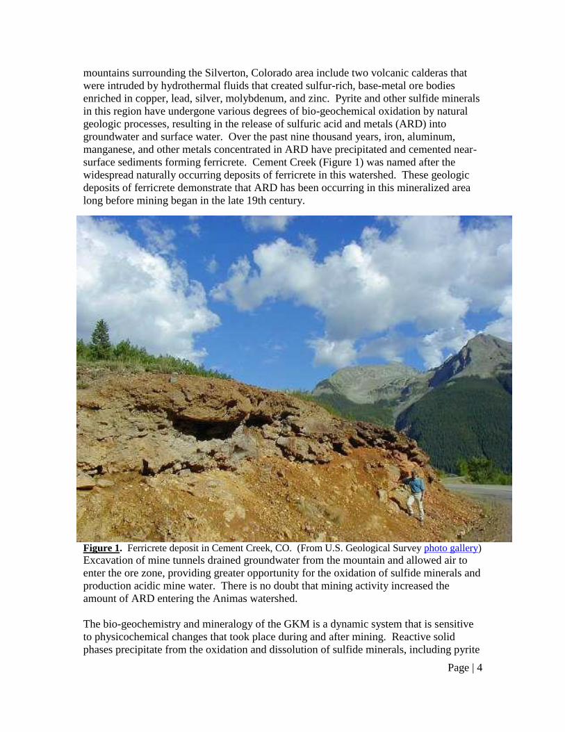
surface sediments forming ferricrete. Cement Creek (Figure 1) was named after the
widespread naturally occurring deposits of ferricrete in this watershed. These geologic
deposits of ferricrete demonstrate that ARD has been occurring in this mineralized area
long before mining began in the late 19th century.
Figure 1. Ferricrete deposit in Cement Creek, CO. (From U.S. Geological Survey photo gallery) Excavation of mine tunnels drained groundwater from the mountain and allowed air to
enter the ore zone, providing greater opportunity for the oxidation of sulfide minerals and
production acidic mine water. There is no doubt that mining activity increased the
amount of ARD entering the Animas watershed.
The bio-geochemistry and mineralogy of the GKM is a dynamic system that is sensitive
to physicochemical changes that took place during and after mining. Reactive solid
phases precipitate from the oxidation and dissolution of sulfide minerals, including pyrite
Page | 5
and chalcopyrite at the GKM. These phases commonly include ferric (oxy)hydroxide,
gypsum, jarosite, and schwertzmannite, which react with mine water producing an acidic
metal-sulfate-rich solution. Acid rock drainage has high concentrations of dissolved and
total calcium, magnesium, sodium, sulfate, iron, aluminum, manganese, and other metals
that influence surface-water quality in the region.
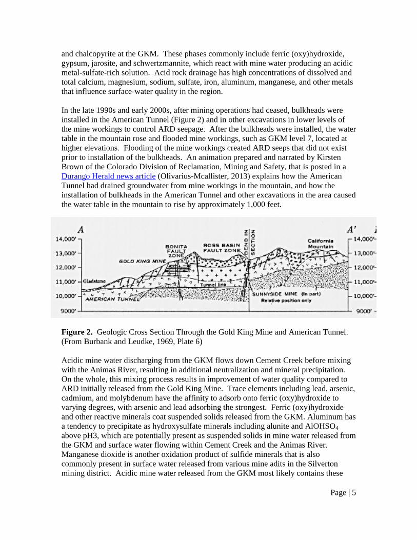
In the late 1990s and early 2000s, after mining operations had ceased, bulkheads were
installed in the American Tunnel (Figure 2) and in other excavations in lower levels of
the mine workings to control ARD seepage. After the bulkheads were installed, the water
table in the mountain rose and flooded mine workings, such as GKM level 7, located at
higher elevations. Flooding of the mine workings created ARD seeps that did not exist
prior to installation of the bulkheads. An animation prepared and narrated by Kirsten
Brown of the Colorado Division of Reclamation, Mining and Safety, that is posted in a
Durango Herald news article (Olivarius-Mcallister, 2013) explains how the American
Tunnel had drained groundwater from mine workings in the mountain, and how the
installation of bulkheads in the American Tunnel and other excavations in the area caused
the water table in the mountain to rise by approximately 1,000 feet.
Figure 2. Geologic Cross Section Through the Gold King Mine and American Tunnel.
(From Burbank and Leudke, 1969, Plate 6)
Acidic mine water discharging from the GKM flows down Cement Creek before mixing
with the Animas River, resulting in additional neutralization and mineral precipitation.
On the whole, this mixing process results in improvement of water quality compared to
ARD initially released from the Gold King Mine. Trace elements including lead, arsenic,
cadmium, and molybdenum have the affinity to adsorb onto ferric (oxy)hydroxide to
varying degrees, with arsenic and lead adsorbing the strongest. Ferric (oxy)hydroxide
and other reactive minerals coat suspended solids released from the GKM. Aluminum has
a tendency to precipitate as hydroxysulfate minerals including alunite and AlOHSO4
above pH3, which are potentially present as suspended solids in mine water released from
the GKM and surface water flowing within Cement Creek and the Animas River.
Manganese dioxide is another oxidation product of sulfide minerals that is also
commonly present in surface water released from various mine adits in the Silverton
mining district. Acidic mine water released from the GKM most likely contains these
Page | 6
reactive minerals in the suspended fraction that typically can be transported tens to
hundreds of kilometers down river during storm events.
Metals and other chemicals concentrated in Animas River water are transported in both
the dissolved and suspended phases with the majority of the contaminant mass occurring
in the suspended fraction. Adsorption, precipitation, and co-precipitation are the
dominant processes controlling the chemistry and mineralogy of the suspended fraction.
The ability of the Animas River to transport large volumes of suspended sediment is
related to the steepness of the gradient, which directly controls flow velocity that
decreases south of Silverton. The riverbed area downstream of where the gradient
decreases is characterized by low-energy flow environments where mine-waste sediment
and associated heavy metals may have deposited and accumulated for decades.
Accumulation of contaminated sediments most likely presents significant long-term
potential sources of heavy metal migration into New Mexico, especially during storm
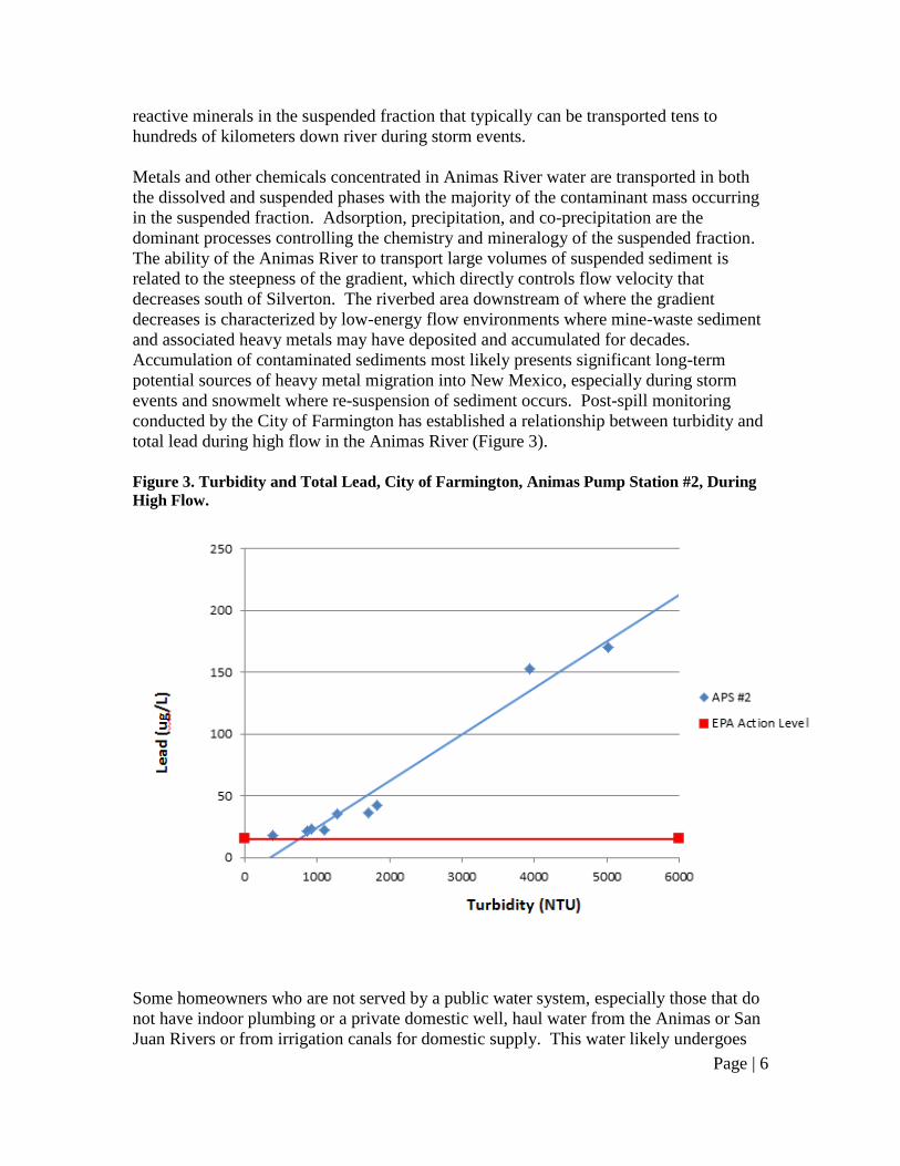
events and snowmelt where re-suspension of sediment occurs. Post-spill monitoring
conducted by the City of Farmington has established a relationship between turbidity and
total lead during high flow in the Animas River (Figure 3).
Figure 3. Turbidity and Total Lead, City of Farmington, Animas Pump Station #2, During
High Flow.
Some homeowners who are not served by a public water system, especially those that do
not have indoor plumbing or a private domestic well, haul water from the Animas or San
Juan Rivers or from irrigation canals for domestic supply. This water likely undergoes
Page | 7
minimal treatment; the NMED has previously issued advisories for at-home chlorination
of water to disinfect. Without appropriate treatment, users of hauled surface water may
be exposed to dissolved and suspended metals in their drinking water.
A review of historical monitoring data for public water systems that divert water from the
Animas River provides no evidence that Primary Drinking Water Standards for metals
have ever been exceeded in the drinking water delivered to consumers (N.M. Department
of Public Health, 1967; Garcia and Olaechea, 1974; Garcia and Pierce, 1980). All of
these public water supply systems utilize a sedimentation basin or reservoir, as well as a
treatment system to further decrease suspended solids concentrations. Sedimentation and
treatment provide significant protection for the subject drinking water against any
suspended-phase heavy metals that may migrate from the Silverton mining area.
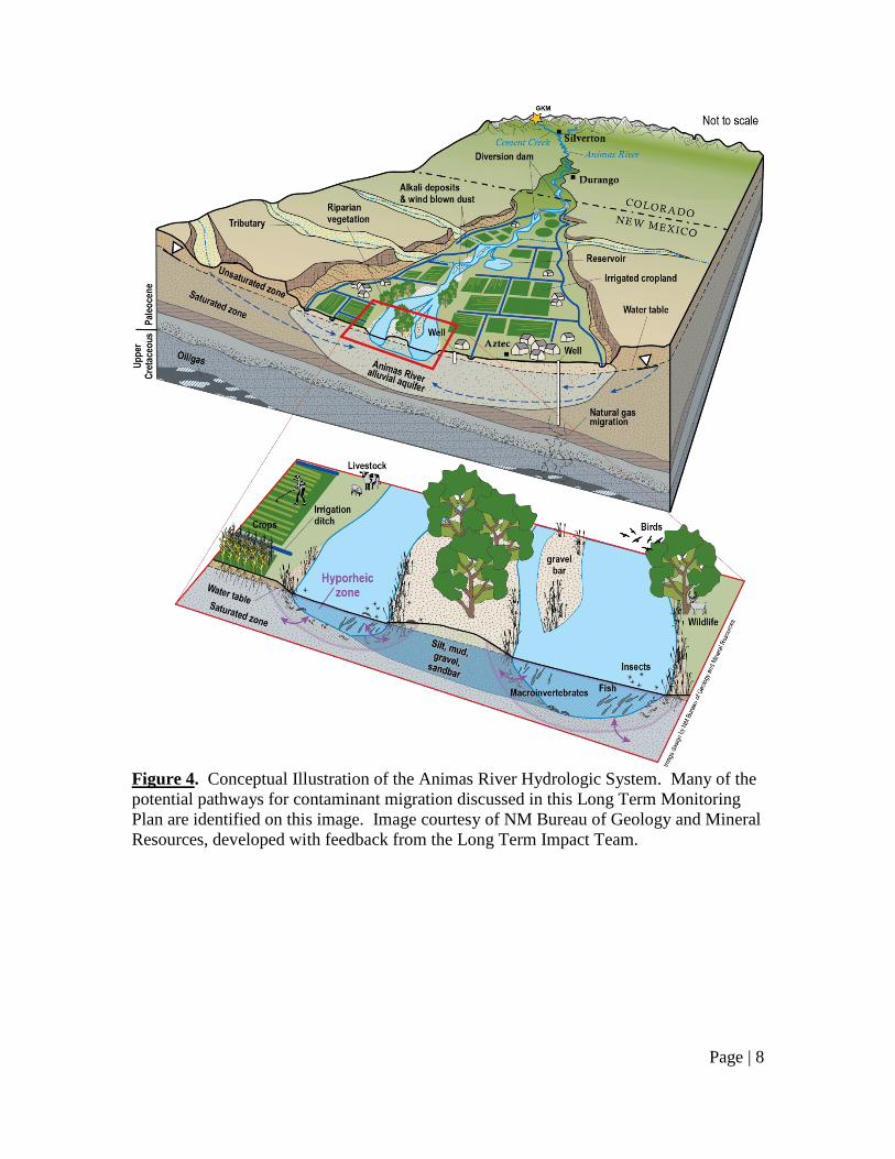
A conceptual illustration of the Animas River hydrologic system is shown in Figure 4.
The Animas River valley alluvial aquifer in Colorado receives base flow from
groundwater (Von Gerard et al., 2007). Flow of circumneutral pH groundwater into the
river provides a source of dilution of long-term ARD, and of historical mining waste
spills that have occurred in the past near Silverton. The New Mexico Bureau of Geology
and Mineral Resources (NMBGMR) collected water level measurements from
approximately 80 private domestic water supply wells, providing the first glace at the
water table of the regional alluvial aquifer. Data from the August sampling event
indicates that the Animas River is a gaining reach along its length extending from the
Colorado-New Mexico state line down to Farmington, NM where the Animas River joins
the San Juan River (NMBGMR, 2015 [unpublished data]). As such, the Animas River is
believed to be predominantly gaining in the Aztec-Cedar Hill area. Some of the water
diverted from the river into irrigation ditches subsequently recharges the alluvial aquifer
in irrigated croplands and along the length of the ditches. It is can be expected that
gaining/losing reaches of the Animas River will change during winter conditions when
irrigation is not occurring.
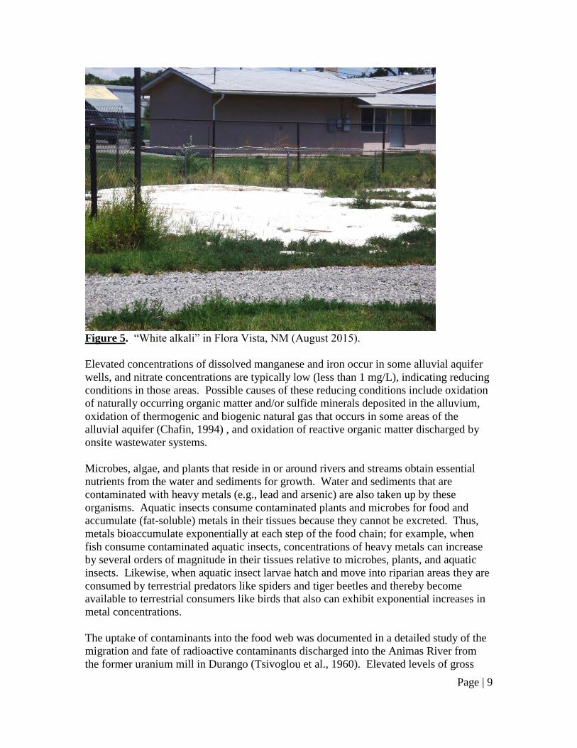
Alluvial groundwater typically contains a substantially higher concentration of total
dissolved solids (TDS) compared to Animas River water. Potential sources of elevated
groundwater TDS may include cation exchange, dissolution of soluble sulfate minerals
present in the alluvium, evaporation of groundwater in waterlogged valley areas (as
evidenced by “white alkali” accumulation, Figure 5), upwelling of mineralized
groundwater from bedrock units underlying the alluvium, and discharges from onsite
wastewater systems especially those that receive waste from salt-based water softeners.
Page | 8
Figure 4. Conceptual Illustration of the Animas River Hydrologic System. Many of the
potential pathways for contaminant migration discussed in this Long Term Monitoring
Plan are identified on this image. Image courtesy of NM Bureau of Geology and Mineral
Resources, developed with feedback from the Long Term Impact Team.
Page | 9
Figure 5. “White alkali” in Flora Vista, NM (August 2015).
Elevated concentrations of dissolved manganese and iron occur in some alluvial aquifer
wells, and nitrate concentrations are typically low (less than 1 mg/L), indicating reducing
conditions in those areas. Possible causes of these reducing conditions include oxidation
of naturally occurring organic matter and/or sulfide minerals deposited in the alluvium,
oxidation of thermogenic and biogenic natural gas that occurs in some areas of the
alluvial aquifer (Chafin, 1994) , and oxidation of reactive organic matter discharged by
onsite wastewater systems.
Microbes, algae, and plants that reside in or around rivers and streams obtain essential
nutrients from the water and sediments for growth. Water and sediments that are
contaminated with heavy metals (e.g., lead and arsenic) are also taken up by these
organisms. Aquatic insects consume contaminated plants and microbes for food and
accumulate (fat-soluble) metals in their tissues because they cannot be excreted. Thus,
metals bioaccumulate exponentially at each step of the food chain; for example, when
fish consume contaminated aquatic insects, concentrations of heavy metals can increase
by several orders of magnitude in their tissues relative to microbes, plants, and aquatic
insects. Likewise, when aquatic insect larvae hatch and move into riparian areas they are
consumed by terrestrial predators like spiders and tiger beetles and thereby become
available to terrestrial consumers like birds that also can exhibit exponential increases in
metal concentrations.
The uptake of contaminants into the food web was documented in a detailed study of the
migration and fate of radioactive contaminants discharged into the Animas River from
the former uranium mill in Durango (Tsivoglou et al., 1960). Elevated levels of gross
Page | 10
alpha, gross beta, and radium were detected in algae and in aquatic insects downstream
from the mill.
Potential Human Exposure Pathways for Heavy Metals in the Animas River
Ingestion of surface water (river water and irrigation ditch water)
Seepage of surface water into the alluvial aquifer and ingestion of contaminated
well water
Flooding and inundation of improperly sealed domestic water wells, entry of
heavy metals in flood water into wells, and ingestion of contaminated well water
Skin contact with surface water and sediment
Desiccation of river, ditch or cropland sediment, and subsequent inhalation of
windborne sediment
Uptake of heavy metals into fish, livestock, wildlife and/or crops and ingestion of
contaminated food
Data Gaps
Historical and ongoing contaminant loadings to the Animas and San Juan
watersheds
Background-baseline contaminant concentrations in sediment and water caused
by natural geologic sources and historical mining and milling
Distribution and mass balance of contaminants in sediment and water
Complete characterization of ground and surface water quality (metal speciation,
stable isotopes, microorganisms)
Aquifer-river-irrigation ditch hydraulics
Uptake of contaminants by plants, livestock, macro-invertebrates, fish, and
wildlife
Toxicological and ecological risk assessment
Impact of storm events on sediment, and ground and surface water quality
Patterns of consumption by residents for human exposure pathways (discussed
above)
Long Term Monitoring Plan Outline
The overarching goals of the Long Term Monitoring Plan are to:
1. Identify the impacts of the August 5, 2015 spill on water quality and the
environment in New Mexico and, to the extent possible, differentiate this from
previous spills, historical acid mine drainage, and naturally occurring acid rock
drainage over geological time; and
2. Generate the data needed to perform an assessment of potential exposure
pathways and risks to public health, public and private drinking water sources,
water-based recreation, livestock, irrigated agriculture, and fish and other wildlife.
Page | 11
To achieve these goals, specific monitoring elements are summarized below. The
monitoring elements include work that the Long Term Impact Team has determined need
to be performed. Detailed technical work plans have been developed by the Long Term
Impact Team for each of the technical monitoring elements and are summarized below.
Additional funding and resources are needed, however, to fully perform all of the
monitoring proposed. The Long Term Monitoring Plan will be dynamic and subject to
data-driven modifications as observations and test results become available.
For the purpose of this monitoring plan, and based upon information presented in the
previous sections, the following metals are of concern with regard to acid rock and mine
drainage and to the GKM spill: arsenic, cadmium, chromium, copper, iron, lead,
manganese, mercury, and zinc.
1. Public Drinking Water Systems
Goals: Determine if the GKM spill will have any impact on the water sources used by
public water supply systems; ensure that public water systems deliver drinking water that
complies with the National Primary Drinking Water Regulations; and monitor for
accumulation of heavy metals in drinking-water treatment infrastructure.
New Mexico Environment Department (NMED) Actions:
Continue to monitor entry points of public water supply in accordance with
compliance monitoring schedules and laboratory analyses required by the Safe
Drinking Water Act (SDWA). Increase sampling frequency, if appropriate, in
response to any detection of increased heavy metal concentrations in treated water
being served. Add source water monitoring, as needed if treatment is not treating
raw water adequately and metals are being detected at the entry point.
Provide outreach and education at public meetings on source water protection
(SWP) planning and offer individual assistance to each public water system with a
drinking water source of supply in the Animas River watershed. Provide
information and education on potential regional planning activities, where
multiple water systems protect sources of drinking water and plan for
emergencies together.
City of Farmington (COF) Actions:
Establish real time monitoring at COF source water intakes for turbidity, and take
appropriate actions when turbidity increases to levels of concern to the COF.
Establish a communication system to provide email notice to other public water
systems that divert water from the Animas River when turbidity levels in river
water reach 400 NTU.
Monitor sedimentation basins for evidence of heavy metal buildup.
2. Surface Water Quality
Page | 12
Goals: Determine if surface-water quality has changed as a result of the GKM spill, and
evaluate any changes with regulatory standards and criteria.
Actions:
Install field instrumentation at ten USGS stream gaging stations in the Animas
and San Juan Rivers to monitor for turbidity, pH, specific conductance, and
temperature.
Make real-time data for turbidity, pH, specific conductance, and temperature
provisionally available on the USGS Water Quality Watch website, along with
flow rate which is already measured by USGS at the 11 gaging stations and
available on the WaterWatch website.
Make the real-time water-quality and flow data available for subscription e-mail
and text alerts to public water systems and others through the USGS Water Alert
service, which will send automated messages when field measurements exceed
specified levels.
Install and manage nine ISCO auto-samplers and associated samples, co-located
with the 10 gaging stations where water quality measurements are being collected.
Conduct baseflow sampling for surface water quality sampling for field
parameters, total and dissolved solids, anions/cations, dissolved and total metals,
suspended solids on filter paper for total metals, bacteria, Bacteroides, nitrogen,
and phosphorus.
Development of a reverse-911 system to be used to communicate alerts and
information on surface water quality, as relevant, to area irrigators and farmers.
Triggers for alerts and information will be based on data collected from the
Animas and San Juan Rivers, including data collected at the USGS sondes
locations.
In anticipation of high flows in the Animas and San Juan Rivers during 2016 Spring
runoff, the USGS installed four sondes in New Mexico. These locations are currently
operational and the data can be accessed on the USGS WaterQualityWatch website.
3. Sediment (Stream, Irrigation Ditches and Irrigated Croplands)
Goals:
Determine if elevated heavy metal concentrations presently occur in stream and
irrigation ditch sediment, and in soil that has been irrigated with water diverted
from the Animas River; and
Monitor the migration of contaminated surface water sediment from Colorado
into New Mexico, as it pertains to irrigated agriculture and the river-agricultural
land interface.
Actions:
Initial and periodic future sampling, especially after runoff/storm events, of
surface water sediment and irrigated soils for heavy metals and evidence of
increasing concentrations migrating into NM from CO.
Page | 13
Facilitate coordination between ditch associations and public water systems to
ensure that future ditch flushing does not adversely impact drinking water intakes.
4. Solids Characterization
Goals: Determine specific form of contaminants in GKM spill solids and assess likely
release and re-release pathways. Provide characterization support for other tasks in the
monitoring plan.
Actions:
Review solid characterization data for GKM site, surrounding mines, and mine
waters to establish likely initial forms of solid contaminants.
Directly characterize solids and associated metals from water and sediment along
the flow path.
Model the likely transformation and release of mixed metals in GKM spill solids
in different depositional environments.
5. Riverbed and Shallow Alluvium Interactions
Goals: Evaluate the potential for transport, sequestration, and release of heavy metals in
riverbed sediments and the shallow alluvium along the Animas and San Juan river
corridor. Hydraulic and geochemical interactions between the river water column,
riverbed sediments, and the shallow alluvial aquifer are quantified with: 1) a detailed
compilation and reanalysis of existing well and surface water quantity and quality data in
areas affected by the event; 2) synoptic sampling campaigns; and 3) installation of high-
frequency monitoring sites.
Actions:
Sample surface water, near-river wells, stream sediment, rock coatings, and
hyporheic zone sediment and pore fluid at twenty sites from Cement Creek, CO,
through NM, and into Bluff, UT for general chemistry and trace metals.
Compilation and reanalysis of legacy data in order to establish a base-line to
evaluate recovery against.
6. Regional Water Table Mapping
Goal: Map the regional water table on a seasonal basis and define hydraulic
relationships between groundwater and surface water.
Actions:
Measure water levels in surface water (both rivers and irrigation ditches) and in
up to 80 wells seasonally for two years.
Install instrumentation with continuous water level recorders in up to 25 wells.
Prepare water table maps for each measurement event with an interpretive report
on groundwater flow direction/velocity, and on interactions between ground and
surface water.
Page | 14
7. Groundwater Quality
Goal: Determine if groundwater quality has been impacted by the GKM spill.
Actions:
Map and evaluate water quality data collected by the EPA in August 2015 from
private domestic wells that were self-identified by residents and sampled for
laboratory analysis.
Identify additional private water supply wells that may be influenced by recharge
from irrigation ditches and sample for general chemistry and trace metals.
If possible, identify indicator parameters that can be used to monitor groundwater
for possible impacts from the spill. Select wells for additional sampling of
indicator parameters based upon hydraulic relationships to rivers and irrigation
ditches.
Identify private domestic wells that are at risk of being inundated by floodwater
that may contain mine waste; sample for heavy metals and bacteria.
8. Ongoing and Potential Future Discharges in the Mining Area
Goals: Identify and characterize ongoing and potential future discharges of mine waste
into the Animas watershed.
Actions:
Identify locations, volumes and chemical quality of water impounded in mine
workings in the upper Animas watershed.
Identify and chemically characterize ongoing mine water seeps and gauge flow
rates.
Identify locations of waste rock and mill tailings piles that have the potential to
discharge into surface water.
9. Airborne Dust
Goal: Determine if the GKM spill has created potentially unhealthy contaminant
concentrations in airborne dust.
Actions:
After the first year of monitoring data for sediment is available, the Long Term
Impact Team will review the data and make a decision on what monitoring, if
any, is necessary for airborne dust.
10. Plants and Animals
Goals: 1. Determine if GKM spill contaminants have adversely affected, or are being
accumulated by, aquatic and riparian plants and animals.
Page | 15
2. Determine how contamination from the GKM spill has affected microbial
communities downstream of the site.
3. Determine if GKM spill contaminants have adversely affected, or are being
accumulated by, fish and wildlife.
4. Determine if elevated heavy metal concentrations occur in agricultural crops that
have been irrigated with water from the Animas River.
Actions:
Monitor and, when effects are observed or expected, sample:
Benthic microbes and macro-invertebrates
Riparian invertebrates
Fish
Amphibians and reptiles
Terrestrial wildlife
Birds
Livestock
Crops
11. Biomonitoring
Goal: The Department of Health continues its biomonitoring work through the Four
Corners States Biomonitoring Consortium.
Actions: Farmington-area residents will be recruited to assess levels of heavy metals in
their private well water and urine, as described in the existing Internal Review Board-
approved methodology.
12. Informational Conference
Goal: Disseminate information and results from the monitoring and research efforts
outlined in this Long Term Monitoring Plan. Bring together academics, agencies,
representatives, and community members and provide a forum for addressing concerns
and questions over the GKM spill and the continuing monitoring efforts.
Actions: Coordinate an informational conference sometime during the Spring of 2016,
in Farmington, New Mexico.
13. Community Outreach and Involvement
Goal: Keep the public informed of the results from the monitoring and research efforts
outlined in this Plan. Provide opportunities for public comment on the progress and
direction of monitoring activities.
Actions: Distribute written informational material to the public, host periodic public
meetings, create and support a Long-Term Citizen Advisory Committee to work with the

Page | 16
technical Long Term Impact Team to ensure that citizen and stakeholder concerns
continue to be carried forward.
Page | 17
References Cited
Burbank, W.S. and R.G. Leudke, 1969, Geology and Ore Deposits of the Eureka and
Adjoining Districts, San Juan Mountains, Colorado, U.S. Geological Survey Professional
Paper 535. http://pubs.usgs.gov/pp/0535/report.pdf, Plate 6,
http://pubs.usgs.gov/pp/0535/plate-6.pdf
Chafin, D.T., 1994, Sources and Migration Pathways of Natural Gas in Near-Surface
Ground Water Beneath the Animas River Valley, Colorado and New Mexico, U.S.
Geological Survey Water Resources Investigations Report 94-4006.
http://pubs.er.usgs.gov/publication/wri944006
Church, S.E., von Guerard, Paul, and Finger, S.E., eds., 2007, Integrated investigations of
environmental effects of historical mining in the Animas River watershed, San Juan
County, Colorado: U.S. Geological Survey Professional Paper 1651, 1,096 p. plus CD-
ROM. [In two volumes.] http://pubs.usgs.gov/pp/1651/
Garcia, F.N. and P.G. Olaechea, 1974, New Mexico Public Water Supplies Chemical
Data, E.M. Environmental Improvement Agency open file report.
Garica, F.N. and S.T. Pierce, 1980, Chemical Quality of New Mexico Community Water
Supplies, N.M. Environmental Improvement Division open file report.
New Mexico Department of Public Health (NMDPH), 1967, Chemical Analyses of the
Municipal Drinking Water Supplies, open file report.
Olivarius-Mcallister, C., 2013, Superfund: A dirty word to some in Silverton, Durango
Herald, August 3, 2013.
http://www.durangoherald.com/article/20130803/NEWS01/130809831/Superfund:-A-
dirty-word-to-some-in-Silverton
Stanton, M.R., D.B. Yager, D.L. Fey and W.G. Wright, 2007, Formation and
geochemical significance of iron bog deposits,
http://pubs.usgs.gov/pp/1651/downloads/Vol2_combinedChapters/vol2_chapE14.pdf In
Church, S.E., von Guerard, Paul, and Finger, S.E., eds., Integrated investigations of
environmental effects of historical mining in the Animas River watershed, San Juan
County, Colorado: U.S. Geological Survey Professional Paper 1651, 1,096 p. plus CD-
ROM. [In two volumes.] http://pubs.usgs.gov/pp/1651/
Tsivoglou, E.C., Stein, M., and Towne, W.W., 1960, Control of Radioactive Pollution of
the Animas River, Water Pollution Control Federation Journal, Volume 32, No. 3 Part 1,
pp. 262-287.
Vincent, K.R., S.E. Church and L. Wirt, 2007, Geomorphology of Cement Creek and its
relation to ferricrete deposits,
Page | 18
http://pubs.usgs.gov/pp/1651/downloads/Vol2_combinedChapters/vol2_chapE16.pdf In
Church, S.E., von Guerard, Paul, and Finger, S.E., eds., Integrated investigations of
environmental effects of historical mining in the Animas River watershed, San Juan
County, Colorado: U.S. Geological Survey Professional Paper 1651, 1,096 p. plus CD-
ROM. [In two volumes.] http://pubs.usgs.gov/pp/1651/
Von Gerard, P., S.E. Church, D.B. Yager and J.M. Besser, 2007, The Animas River
Watershed, San Juan County, Colorado,
http://pubs.usgs.gov/pp/1651/downloads/Vol1_combinedChapters/vol1_chapB.pdf In
Church, S.E., von Guerard, Paul, and Finger, S.E., eds., Integrated investigations of
environmental effects of historical mining in the Animas River watershed, San Juan
County, Colorado: U.S. Geological Survey Professional Paper 1651, 1,096 p. plus CD-
ROM. [In two volumes.] http://pubs.usgs.gov/pp/1651/