Embed Size (px)
Citation preview
© CRC LEME 2003 Gidji palaeochannel sediments Page 1
GOLD-BEARING PALAEOCHANNEL SEDIMENTS AT GIDJI, WESTERN AUSTRALIAC.B. Johnson1 and K.G. McQueen
CRC LEME, University of Canberra, Canberra, ACT 26011. Placer Dome Asia Pacic Pty Ltd, PO Box 33, Laverton, WA 6440
INTRODUCTION
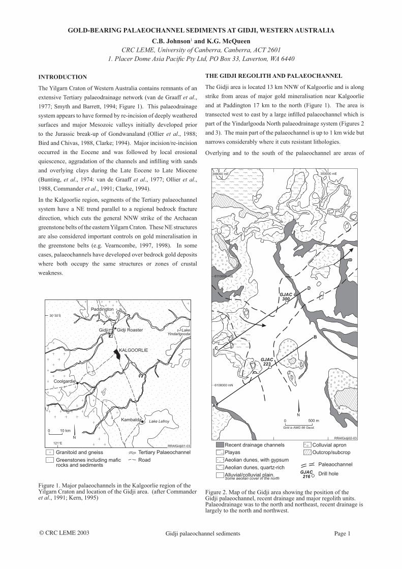
The Yilgarn Craton of Western Australia contains remnants of an extensive Tertiary palaeodrainage network (van de Graaff et al., 1977; Smyth and Barrett, 1994; Figure 1). This palaeodrainage system appears to have formed by re-incision of deeply weathered surfaces and major Mesozoic valleys initially developed prior to the Jurassic break-up of Gondwanaland (Ollier et al., 1988; Bird and Chivas, 1988, Clarke; 1994). Major incision/re-incision occurred in the Eocene and was followed by local erosional quiescence, aggradation of the channels and inlling with sands and overlying clays during the Late Eocene to Late Miocene (Bunting, et al., 1974: van de Graaff et al., 1977; Ollier et al., 1988, Commander et al., 1991; Clarke, 1994).
In the Kalgoorlie region, segments of the Tertiary palaeochannel system have a NE trend parallel to a regional bedrock fracture direction, which cuts the general NNW strike of the Archaean greenstone belts of the eastern Yilgarn Craton. These NE structures are also considered important controls on gold mineralisation in the greenstone belts (e.g. Vearncombe, 1997, 1998). In some cases, palaeochannels have developed over bedrock gold deposits where both occupy the same structures or zones of crustal weakness.
Figure 1. Major palaeochannels in the Kalgoorlie region of the Yilgarn Craton and location of the Gidji area. (after Commander et al., 1991; Kern, 1995)
THE GIDJI REGOLITH AND PALAEOCHANNEL
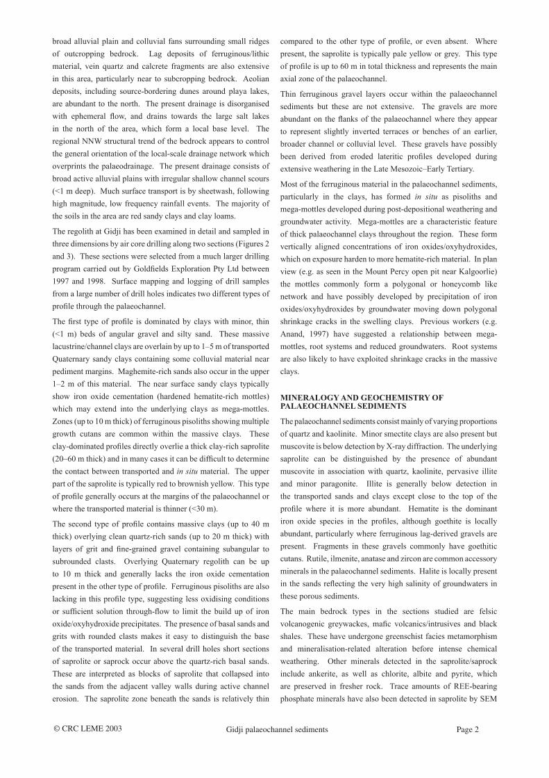
The Gidji area is located 13 km NNW of Kalgoorlie and is along strike from areas of major gold mineralisation near Kalgoorlie and at Paddington 17 km to the north (Figure 1). The area is transected west to east by a large inlled palaeochannel which is part of the Yindarlgooda North palaeodrainage system (Figures 2 and 3). The main part of the palaeochannel is up to 1 km wide but narrows considerably where it cuts resistant lithologies.
Overlying and to the south of the palaeochannel are areas of
Figure 2. Map of the Gidji area showing the position of the Gidji palaeochannel, recent drainage and major regolith units. Palaeodrainage was to the north and northeast, recent drainage is largely to the north and northwest.
© CRC LEME 2003 Gidji palaeochannel sediments Page 2
broad alluvial plain and colluvial fans surrounding small ridges of outcropping bedrock. Lag deposits of ferruginous/lithic material, vein quartz and calcrete fragments are also extensive in this area, particularly near to subcropping bedrock. Aeolian deposits, including source-bordering dunes around playa lakes, are abundant to the north. The present drainage is disorganised with ephemeral ow, and drains towards the large salt lakes in the north of the area, which form a local base level. The regional NNW structural trend of the bedrock appears to control the general orientation of the local-scale drainage network which overprints the palaeodrainage. The present drainage consists of broad active alluvial plains with irregular shallow channel scours (<1 m deep). Much surface transport is by sheetwash, following high magnitude, low frequency rainfall events. The majority of the soils in the area are red sandy clays and clay loams.
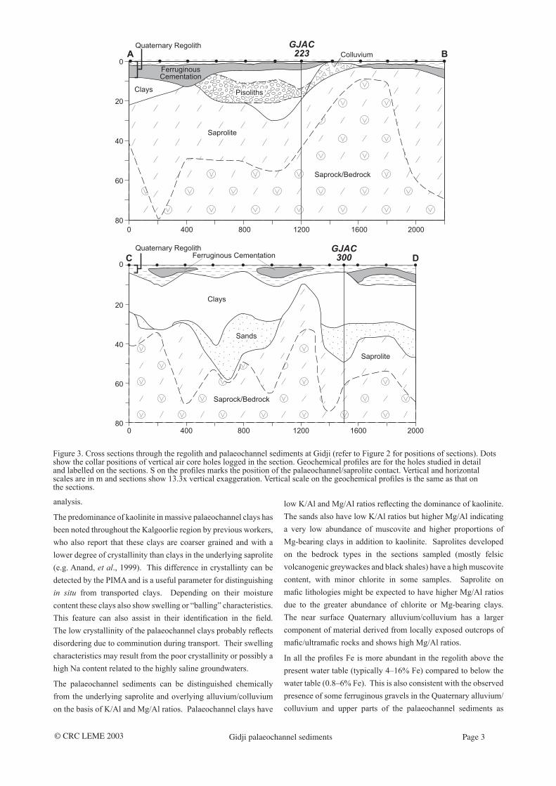
The regolith at Gidji has been examined in detail and sampled in three dimensions by air core drilling along two sections (Figures 2 and 3). These sections were selected from a much larger drilling program carried out by Goldelds Exploration Pty Ltd between 1997 and 1998. Surface mapping and logging of drill samples from a large number of drill holes indicates two different types of prole through the palaeochannel.
The rst type of prole is dominated by clays with minor, thin (<1 m) beds of angular gravel and silty sand. These massive lacustrine/channel clays are overlain by up to 1–5 m of transported Quaternary sandy clays containing some colluvial material near pediment margins. Maghemite-rich sands also occur in the upper 1–2 m of this material. The near surface sandy clays typically show iron oxide cementation (hardened hematite-rich mottles) which may extend into the underlying clays as mega-mottles. Zones (up to 10 m thick) of ferruginous pisoliths showing multiple growth cutans are common within the massive clays. These clay-dominated proles directly overlie a thick clay-rich saprolite (20–60 m thick) and in many cases it can be difcult to determine the contact between transported and in situ material. The upper part of the saprolite is typically red to brownish yellow. This type of prole generally occurs at the margins of the palaeochannel or where the transported material is thinner (<30 m).
The second type of prole contains massive clays (up to 40 m thick) overlying clean quartz-rich sands (up to 20 m thick) with layers of grit and ne-grained gravel containing subangular to subrounded clasts. Overlying Quaternary regolith can be up to 10 m thick and generally lacks the iron oxide cementation present in the other type of prole. Ferruginous pisoliths are also lacking in this prole type, suggesting less oxidising conditions or sufcient solution through-ow to limit the build up of iron oxide/oxyhydroxide precipitates. The presence of basal sands and grits with rounded clasts makes it easy to distinguish the base of the transported material. In several drill holes short sections of saprolite or saprock occur above the quartz-rich basal sands. These are interpreted as blocks of saprolite that collapsed into the sands from the adjacent valley walls during active channel erosion. The saprolite zone beneath the sands is relatively thin
compared to the other type of prole, or even absent. Where present, the saprolite is typically pale yellow or grey. This type of prole is up to 60 m in total thickness and represents the main axial zone of the palaeochannel.
Thin ferruginous gravel layers occur within the palaeochannel sediments but these are not extensive. The gravels are more abundant on the anks of the palaeochannel where they appear to represent slightly inverted terraces or benches of an earlier, broader channel or colluvial level. These gravels have possibly been derived from eroded lateritic proles developed during extensive weathering in the Late Mesozoic–Early Tertiary.
Most of the ferruginous material in the palaeochannel sediments, particularly in the clays, has formed in situ as pisoliths and mega-mottles developed during post-depositional weathering and groundwater activity. Mega-mottles are a characteristic feature of thick palaeochannel clays throughout the region. These form vertically aligned concentrations of iron oxides/oxyhydroxides, which on exposure harden to more hematite-rich material. In plan view (e.g. as seen in the Mount Percy open pit near Kalgoorlie) the mottles commonly form a polygonal or honeycomb like network and have possibly developed by precipitation of iron oxides/oxyhydroxides by groundwater moving down polygonal shrinkage cracks in the swelling clays. Previous workers (e.g. Anand, 1997) have suggested a relationship between mega-mottles, root systems and reduced groundwaters. Root systems are also likely to have exploited shrinkage cracks in the massive clays.
MINERALOGY AND GEOCHEMISTRY OF PALAEOCHANNEL SEDIMENTS
The palaeochannel sediments consist mainly of varying proportions of quartz and kaolinite. Minor smectite clays are also present but muscovite is below detection by X-ray diffraction. The underlying saprolite can be distinguished by the presence of abundant muscovite in association with quartz, kaolinite, pervasive illite and minor paragonite. Illite is generally below detection in the transported sands and clays except close to the top of the prole where it is more abundant. Hematite is the dominant iron oxide species in the proles, although goethite is locally abundant, particularly where ferruginous lag-derived gravels are present. Fragments in these gravels commonly have goethitic cutans. Rutile, ilmenite, anatase and zircon are common accessory minerals in the palaeochannel sediments. Halite is locally present in the sands reecting the very high salinity of groundwaters in these porous sediments.
The main bedrock types in the sections studied are felsic volcanogenic greywackes, mac volcanics/intrusives and black shales. These have undergone greenschist facies metamorphism and mineralisation-related alteration before intense chemical weathering. Other minerals detected in the saprolite/saprock include ankerite, as well as chlorite, albite and pyrite, which are preserved in fresher rock. Trace amounts of REE-bearing phosphate minerals have also been detected in saprolite by SEM
© CRC LEME 2003 Gidji palaeochannel sediments Page 3
analysis.
The predominance of kaolinite in massive palaeochannel clays has been noted throughout the Kalgoorlie region by previous workers, who also report that these clays are coarser grained and with a lower degree of crystallinity than clays in the underlying saprolite (e.g. Anand, et al., 1999). This difference in crystallinty can be detected by the PIMA and is a useful parameter for distinguishing in situ from transported clays. Depending on their moisture content these clays also show swelling or “balling” characteristics. This feature can also assist in their identication in the eld. The low crystallinity of the palaeochannel clays probably reects disordering due to comminution during transport. Their swelling characteristics may result from the poor crystallinity or possibly a high Na content related to the highly saline groundwaters.
The palaeochannel sediments can be distinguished chemically from the underlying saprolite and overlying alluvium/colluvium on the basis of K/Al and Mg/Al ratios. Palaeochannel clays have
low K/Al and Mg/Al ratios reecting the dominance of kaolinite. The sands also have low K/Al ratios but higher Mg/Al indicating a very low abundance of muscovite and higher proportions of Mg-bearing clays in addition to kaolinite. Saprolites developed on the bedrock types in the sections sampled (mostly felsic volcanogenic greywackes and black shales) have a high muscovite content, with minor chlorite in some samples. Saprolite on mac lithologies might be expected to have higher Mg/Al ratios due to the greater abundance of chlorite or Mg-bearing clays. The near surface Quaternary alluvium/colluvium has a larger component of material derived from locally exposed outcrops of mac/ultramac rocks and shows high Mg/Al ratios.
In all the proles Fe is more abundant in the regolith above the present water table (typically 4–16% Fe) compared to below the water table (0.8–6% Fe). This is also consistent with the observed presence of some ferruginous gravels in the Quaternary alluvium/colluvium and upper parts of the palaeochannel sediments as
Figure 3. Cross sections through the regolith and palaeochannel sediments at Gidji (refer to Figure 2 for positions of sections). Dots show the collar positions of vertical air core holes logged in the section. Geochemical proles are for the holes studied in detail and labelled on the sections. S on the proles marks the position of the palaeochannel/saprolite contact. Vertical and horizontal scales are in m and sections show 13.3x vertical exaggeration. Vertical scale on the geochemical proles is the same as that on the sections.
© CRC LEME 2003 Gidji palaeochannel sediments Page 4
well as development of goethitic pisoliths and mottles in poorly drained and oxidised palaeochannel clays. The Fe content is particularly low below the water table in the prole across the main palaeochannel (<3% Fe), probably reecting greater groundwater movement and ushing of Fe in solution through the porous channel sands and overlying clays.
PALAEOCHANNEL PROCESSES AND IMPLICATIONS FOR LANDSCAPE HISTORY
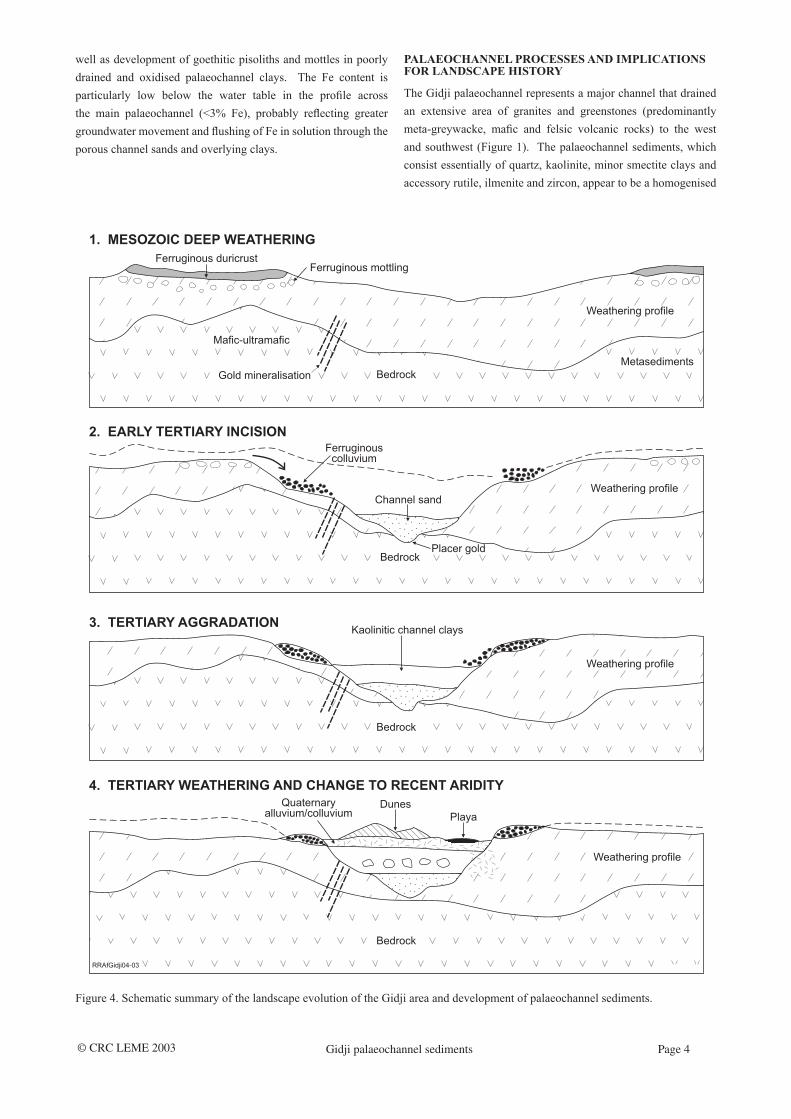
The Gidji palaeochannel represents a major channel that drained an extensive area of granites and greenstones (predominantly meta-greywacke, mac and felsic volcanic rocks) to the west and southwest (Figure 1). The palaeochannel sediments, which consist essentially of quartz, kaolinite, minor smectite clays and accessory rutile, ilmenite and zircon, appear to be a homogenised
Figure 4. Schematic summary of the landscape evolution of the Gidji area and development of palaeochannel sediments.
© CRC LEME 2003 Gidji palaeochannel sediments Page 5
mixture of weathered materials eroded from this palaeocatchment. The very low abundance of muscovite, illite and chlorite in both the clays and the sands suggests either very intense chemical weathering prior to erosion or possibly major post-depositional weathering which has broken down all the phyllosilicates and feldspars to kaolinite. The latter seems less likely as signicant muscovite is preserved in the immediately underlying saprolite. Muscovite and quartz are the major rock-forming minerals most resistant to weathering. During chemical weathering muscovite initially transforms to mixed illite–smectite clay and ultimately to kaolinite (Eggleton, 1998). The abundance of muscovite together with illite in the saprolite suggests the rst stage of muscovite weathering is preserved in this material. Illite is more abundant in the near-upper parts of the proles probably due to incorporation of partly weathered local bedrock in the more recent colluvium/alluvium or as a result of clay development under conditions of high K activity related to aeolian alunite in the regolith (e.g. Bettenay, 1962). The in situ development of mega-mottles and pisoliths with intact multiple cutans clearly indicates precipitation of iron oxides/oxyhydroxides in the palaeochannel sediments. This is consistent with ongoing, post-depositional weathering and solution activity since the Early Tertiary.
The presence of thick saprolite zones beneath the shallow margins of the palaeochannel at Gidji, as well as some early deposited ferruginous gravels and general absence of bedrock clasts in the sediments, are all consistent with a period of intense chemical weathering prior to development of the palaeochannel. The absence or reduced thickness of saprolite beneath the main channel suggests partial stripping of the prole in the channel areas.
The ferruginous gravels at the margins and within the upper part of the palaeochannel contain variably abraded lag and ferruginous pisoliths indicating that this material has undergone some transport from its source, probably ferruginous duricrust formed mainly during the Mesozoic–early Tertiary. The distribution of the gravels indicates transport both prior to and during deposition of the palaeochannel sediments. Ferruginous cementation of Quaternary alluvium and development of ferruginous hardpans and mega-mottles in the palaeochannel clays indicates that Fe mobility and deposition as oxides/oxyhydroxides continued through the late Tertiary and possibly into the Quaternary. The near surface Quaternary alluvium/colluvium and some gravel beds in the underlying clays-appear to have a more local (predominantly greenstone lithology) source.
A summary of the landscape history of the Gidji area can be reconstructed from the evidence preserved in the palaeochannel sediments and regolith of different ages (Figure 4). The broad stratigraphy preserved in the palaeochannel is typical of that in the area around Kalgoorlie and represents a change from uvial conditions, as reected by the sands and basal gravels, to uvio-lacustrine conditions, during which the thick kaolinitic clays were deposited. It has been suggested that the change from active channel erosion to low-energy deposition was caused by a major
rise in base level related to one of two Mid-Late Eocene marine transgressions (Clarke, 1994; Carey and Dusci, 1999). Climatic changes, particularly resulting in decreased rainfall and runoff, may also have played a signicant role (Anand et al., 1999). Overlap of playa lakes and older quartz-rich and younger gypsum-bearing dune sands onto the palaeochannel sediments is consistent with a change to more arid conditions in the late Tertiary through to the present. The larger quartz-rich dunes distal to the present playa lakes probably developed prior to evaporites becoming a major source for aeolian materials during peak aridity. Bowler (1976) has suggested a period of peak aridity from 25 000–13 000 years BP. Work in the Kambalda-Norseman area south of Kalgoorlie suggests the development of gypsum-bearing sediments and aeolian deposits commenced in the earliest Pliocene (Clarke, 1998).
REFERENCES
Anand, R.R., 1997. Some aspects of regolith-landform evolution of the Yilgarn Craton – implications for exploration. In: K.F. Cassidy, A.J. Wittaker and S.F. Liu (Editors). An international conference on crustal evolution, metallogeny and exploration of the Yilgarn Craton – an update. Australian Geological Survey Organisation (Geoscience Australia), Canberra. Record 1997/41. pp. 213-218.
Anand, R.R., Phillips, G.N., Compston, D., Cox, A., Galloway, N., Ely, K., Paine, M., Phang, C., Rotherham, J. and Wildman, J.E., 1999. Regolith and geochemistry of the Yandal Greenstone Belt, Yilgarn Craton, Western Australia. In: S.E. Ho, G. Jefress and B. Davis (Editors). Exploration geochemistry for the new millennium. Australian Institute of Geoscientists. Bulletin 30. pp. 13-33.
Bettenay, E., 1962. The salt lake systems and their associated aeolian features in the semi arid regions of Western Australia. Journal of Soil Science, 13: 10-17.
Bird, M. and Chivas, A., 1988. Oxygen isotope dating of the Australian regolith. Nature, 331: 513-516.
Bowler, J.M., 1976. Aridity in Australia: origins and expressions in aeolian landforms and sediments. Earth Science Reviews, 12: 279-310.
Bunting, J.A., van de Graaff, W.J.E. and Jackson, M.J., 1974. Palaeodrainages and the Cainozoic palaeogeography of the Eastern Goldelds, Gibson Desert and Great Victoria Desert. Western Australian Geological Survey, Perth. Annual Report for 1973. pp. 45-50.
Carey, M.L. and Dusci, M.E., 1999. WMC Resources exploration success in lake terrains - applications of element dispersion, Kambalda WA. In: G. Taylor and C. Pain (Editors). Proceedings of Regolith ’98, New Approaches to an Old Continent. CRC LEME, Perth, Australia. pp 135-148.
Clarke, J.D.A., 1994. Evolution of the Lefroy and Cowan palaeodrainages, Western Australia. Australian Journal of Earth Sciences, 41: 55-68.
Clarke, J.D.A., 1998. Ancient landforms of Kambalda and Norseman. Geological Society of Australia. Special Publication 20. pp. 40-49.
Commander, D.P., Kern, A.M. and Smith, R.A., 1991,
© CRC LEME 2003 Gidji palaeochannel sediments Page 6
Hydrogeology of the Tertiary palaeochannels in the Kalgoorlie region (Roe Paleodrainage) Geological Survey of Western Australia. Record 1991/10. 56 pp.
Eggleton, R.A.E., 1998. Weathering. Geological Society of Australia. Special Publication 20. pp. 126-140.
Ollier, C.D., Chan, R.A., Craig, M.A. and Gibson, D.L., 1988. Aspects of landscape history in the Kalgoorlie region, Western Australia. BMR Journal of Australian Geology and Geophysics, 10: 309-321.
Smyth, E.L., and Barrett, D.M., 1994. Geophysical characteristics of the Tertiary palaeochannels in the Yilgarn block, Western Australia. Geophysical signatures of Western Australian mineral deposits. Geology Department and University Extension, University of Western Australia. Publication 26. pp. 417-425.
van de Graaff, W.J.E., Crowe, R.W.A., Bunting, J.A. and Jackson, M.J., 1977. Relict early Cainozoic drainages in arid Western Australia. Zeitschrift für Geomorphologie, 21: 379-400.
Vearncombe, J.R., 1997. Late Archaean deformation and gold mineralisation, the Archaean Yilgarn craton: an overview. Geological Society of Australia. Abstracts 44. p. 69.
Vearncombe, J.R., 1998. Shear zones, fault networks and Archean gold. Geology, 26: 855-858.