Embed Size (px)
Citation preview

GOLBORNE AND LOWTON INFRASTRUCTURE
ASSESSMENT
November 2013
Confident Places, Confident People

2

3
Contents 1. Introduction 2. Infrastructure 3. Transport 4. Education 5. Health 6. Open space and recreation 7. Community facilities 8. Utilities 9. Conclusion
Appendices:
A. Estimated costs of all identified infrastructure schemes B. Worked example indicating estimated costs based on a potential
development scenario C. Potential development scenario D. Initial indicative highway scheme drawings

4
1. INTRODUCTION 1.1 This infrastructure assessment has been prepared to inform the council’s decision-making
on planning applications for housing development in the Golborne and Lowton broad location, as set out in the adopted Wigan Local Plan Core Strategy. It is not part of the local development plan, neither is it a supplementary planning document. It is an evidence document that will be supplemented by other evidence available to the council at the time that decisions are taken, including from applicants, consultees and other third parties. However, it is prepared by the council on the basis of having significant weight in the planning application process.
1.2 The council adopted the Core Strategy on 11 September 2013. Policy SP4 identifies Golborne and Lowton as a broad location for new housing development with approximately 1,000 new homes on safeguarded land to 2026. However there is capacity for double that amount of housing on safeguarded land in Golborne and Lowton and there are parties interested in developing most, if not all of it.
1.3 It had been intended, by the government and the council, that this situation would be resolved through the preparation of a subsequent local development plan. However, national planning policy has changed and the Core Strategy now allows such land to come forward for development in advance of a further local development plan. The requirement is to have a 5 year supply of deliverable housing land and Golborne and Lowton has been identified as a broad location for new housing to contribute towards this supply in the short term. There is therefore a policy presumption that planning permission will be forthcoming for approximately 1,000 new homes on safeguarded land in Golborne and Lowton, and the council has to determine through the planning application process where this should be achieved.
1.4 Policy SP4 allows for development in the broad locations to come forward in advance of the allocation of sites through the subsequent development plan as long as account is taken of:
• The capacity of infrastructure serving the area/site
• The ability to integrate the development with the local community
• The ability to deliver the development including addressing site constraints and provision of the physical and green infrastructure needed
This infrastructure assessment has been prepared to help inform that decision making process.
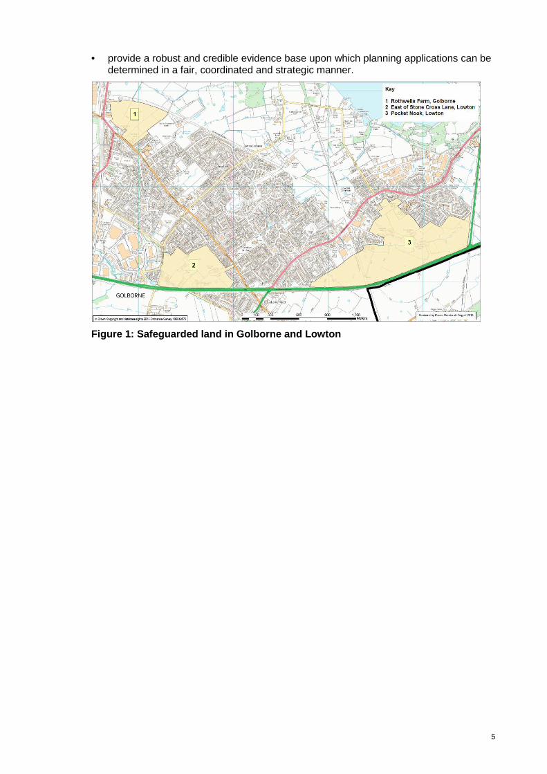
1.5 The areas of safeguarded land from which the 1,000 new homes will be drawn are at Rothwell’s Farm, Golborne; East of Stone Cross Lane, Lowton; and Pocket Nook, Lowton. These are shown in Figure 1.
1.6 This infrastructure assessment generally assesses the impact of the following development scenarios:
• Development focussed at Rothwell’s Farm and East of Stone Cross Lane • Development focussed at Pocket Nook • Development split equally amongst these three locations.
1.7 In summary, this strategic infrastructure capacity assessment for Golborne and Lowton
has been prepared to:
• assess the overall impact of around 1,000 homes on Golborne and Lowton and its infrastructure.
• identify the mitigation needed and estimate the cost of its delivery.
• help establish how 1,000 homes can be best accommodated in Golborne and Lowton with minimum impact on local infrastructure and maximum community benefits.
5
• provide a robust and credible evidence base upon which planning applications can be determined in a fair, coordinated and strategic manner.
Figure 1: Safeguarded land in Golborne and Lowton

6
2 INFRASTRUCTURE
2.1 The following categories of infrastructure are assessed in this document:
• Transport infrastructure; including the impact of development on the highway network, public transport and walking and cycling provision.
• Education infrastructure; specifically the impact of development on primary and
secondary school place provision.
• Health infrastructure; the impact of development on the ability of local residents to access a GP and dental services.
• Open space and recreation • Community infrastructure (including community facilities) • Utilities infrastructure; including gas, electricity, water and sewerage.

7
3 TRANSPORT
3.1 Policy Context
3.1.1 Paragraph 32 of the National Planning Policy Framework states that ‘development should only be prevented or refused on transport grounds where the residual cumulative impacts of development are severe’.
3.1.2 While independent Transport Assessments, submitted as part of planning applications within the broad location, have concluded that proposals taken in isolation will not impact severely on the local transport network, the cumulative impact of the full 1000 homes could be, and is likely to be, severe, given the overall scale of development and the existing congestion issues in Golborne and Lowton.
3.1.3 The cumulative impact of 1000 homes is considerably different to the impact of each site in isolation as each site will each generate traffic onto the same road network and affect capacity at the same junctions. For example, three individual proposals could be deemed to have an insignificant impact on a particular junction when considered in isolation, but cumulatively could render the junction over capacity and in need of mitigation. It is therefore imperative that the cumulative impact of development on transport infrastructure is considered in the determination of planning applications within the broad location.
3.1.4 Policy CP7 of the Core Strategy commits to improving accessibility to key destinations by, amongst other things, maximising the use of the existing bus and rail network; developing and enhancing our on and off-road networks for walking and cycling; and maximising the capacity, efficiency and safety of the road network, reducing, as far as is practicable, the adverse impact of transport on our communities, town centres and the wider environment. These principles will be crucial in guiding our approach within the broad location.
3.1.5 Adhering to these principles requires a coordinated approach, in which the required mitigation measures necessary to address the overall traffic impact are identified, assessed in terms of priority and phased accordingly. To ensure delivery, all developers building within the broad location will be required to make pro-rata financial contributions (per dwelling) towards the delivery of the overall mitigation package needed, regardless of site location or phase of development. This is a fair approach in which all developers contribute evenly to the mitigation of the cumulative impact of the development.
3.2 Mitigating the Impact of Transport
3.2.1 The Council’s adopted Transport Strategy states that connecting people to places and addressing the barriers that make it difficult for people to move around the borough are fundamental issues when considering the impact of transport. The strategy supports CP7 of the Core Strategy through the hierarchical approach to identifying and delivering transport improvements; this is discussed later in this section of the report.
3.2.2 We rely on our transport networks to provide access to jobs, services, schools and shops, and allows us to make the most of our free time. Transport is critical to the economic, social and environmental well being of our communities.
3.2.3 Development needs to take place in the right locations to prioritise sustainable travel (by walking, cycling and public transport), and this is particularly important for connections to key destinations such as town centre, schools, community facilities, recreation facilities etc.
3.3 Transport Assessment Principles
3.3.1 Key transport assessment principles include:
• Reducing the need to travel in the first place, because it physically removes trips off the network.
8
• Transferring trips onto sustainable travel choices to improve congestion by moving car based trips to more efficient modes of transport (walking, cycling and public transport) that use less road space and also help with travel costs, health, and climate change.
• Improving the efficiency of the network to minimise the impact from car based trips. This will need to accommodate driver behaviours (speed limits, traffic calming etc), embracing new economical and technological solutions (including electric vehicles) and physical improvements on the network (junction improvements, new highway connections)
3.3.2 When planning permission is granted for each of the housing sites, there will be a condition on the approval which will require the submission and approval of travel plans to detail how the developer intends to minimise the need for travel and prioritise public transport, cycling and walking opportunities.
3.3.3 The choice of transport mode for longer journeys will be influenced by the convenience and cost of public transport choices and its connectivity with the origin and destinations of each trip. Therefore, developers need to recognise the significantly important role of sustainable travel choices from the outset to help minimise the impact of transport on the existing infrastructure, while providing a balanced approach to the provision of new / improved highway connections.
3.3.4 The council commissioned Transport for Greater Manchester (TfGM) to examine the impact of the 1000 homes on local highway network and to help assess the strategic infrastructure capacity and necessary highway improvements that will be required. The Council will be relying on modelling evidence provided by TfGM, the findings of which are summarised later in this section of the report.
3.4 Transport Baseline: Existing Situation
3.4.1 Golborne and Lowton are located on the southern fringes of the borough and have boundaries with both Warrington and St. Helens district areas. Both Golborne and Lowton have direct connections to the A580 East Lancashire Road via the A573 and A572 respectively, the A572 also provides Lowton with a direct connection to Leigh town centre. The West Coast Main Line also travels through the Golborne area.
3.4.2 Three areas of safeguarded land have been identified comprising the Golborne and Lowton broad location for new development in order to assist in meeting housing needs, particularly to provide choice in the short term. The broad site options are identified earlier in this report and include:
• Rothwells Farm - bounded by B5207 Lowton Road and a dismantled railway line;
• Stone Cross Lane - bounded by B5207 Church Lane, A580 East Lancs Road, Stone Cross Lane and the residential area to the north including Upwood Road; and,
• Pocket Nook - bounded by A580 East Lancs Road, A579 and the residential area to the east and west.
3.4.3 Baseline transport evidence and additional information for the Golborne and Lowton areas have previously been provided for each of the broad site options in the Initial Transport Assessments which were submitted as part of the Examination in Public for the Core Strategy. These are appended to this report (refer to Appendix A), and include:
• existing transport issues (congestion hotspots, rail, bus, walking / cycling; and travel patterns); and
• potential transport interventions / measures.
9
3.5 Sustainable Transport Improvement Measures
3.5.1 Sustainable travel choices are vital in minimising the transport impact from development. There is evidence that residents can adjust their travel patterns through an initiative led by Wigan Council in 2009, which involved more than 800 Standish households taking part in a personalised travel plan study. Walking and cycling to school increased to such an extent that the percentage of pupils being driven to school reduced from 31% to 8%. Car sharing to work increased and use of public transport increased overall.
3.5.2 The following section builds on the initial transport assessment work undertaken and embraces the transport principles set out in this assessment plan in order to help outline and justify the interventions and measures that will be required to minimise the impact from 1,000 units being developed in the Golborne and Lowton area.
3.5.3 At the end of each section, a high level summary is provided to assess the potential impact for mitigating transport concerns.
� overall positive impact O no impact x overall negative impact
3.6 Walking and Cycling
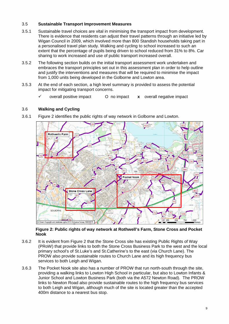
3.6.1 Figure 2 identifies the public rights of way network in Golborne and Lowton.
Figure 2: Public rights of way network at Rothwell’s Farm, Stone Cross and Pocket Nook
3.6.2 It is evident from Figure 2 that the Stone Cross site has existing Public Rights of Way (PRoW) that provide links to both the Stone Cross Business Park to the west and the local primary school’s of St.Luke’s and St.Catherine’s to the east (via Church Lane). The PROW also provide sustainable routes to Church Lane and its high frequency bus services to both Leigh and Wigan.
3.6.3 The Pocket Nook site also has a number of PROW that run north-south through the site, providing a walking links to Lowton High School in particular, but also to Lowton Infants & Junior School and Lowton Business Park (both via the A572 Newton Road). The PROW links to Newton Road also provide sustainable routes to the high frequency bus services to both Leigh and Wigan, although much of the site is located greater than the accepted 400m distance to a nearest bus stop.

10
3.6.4 The Rothwell’s Farm site has PROW that provide sustainable walking links to nearby Golborne High School and also Lowton Road and its high frequency bus services to both Wigan and Leigh.
3.6.5 There are a number of existing pedestrian and cycling provisions on the adopted highway from all three site options which can be utilised for local trips to key destinations.
3.6.6 There is an existing segregated cycle facility along the southern side of the A580 East Lancashire Road, and a Bridleway (Number 254A) which runs along the A579 St Mary’s Bypass, to which walking / cycling connections will be needed from each of the site options.
3.6.7 Walking and cycling trips to the district centres, schools and local amenities from the majority of the Rothwell’s Farm and Stone Cross areas are deemed to be reasonable (within 10 minutes) through the presence of connections to High Street, Church Lane and Nook Lane. However, the footway provision on Nook Lane is particularly poor, which is known to create problems for school journeys especially towards High Street where there are physical width restrictions created by the rail bridge.
3.6.8 While some parts of the Pocket Nook area are within a ‘reasonable’ distance to amenities on St Helens Road, and the far east of the site to amenities off the A579 St Mary’s Bypass, the majority of the area is located too far away for walking trips to be considered a reasonable option.
3.6.9 Pocket Nook site option also includes the route of the Lowton St Mary’s dismantled railway line, which is currently included as part of the initial preferred route for the high speed rail line: phase 2. (More information on this under the rail section). Consideration is needed with regards to a multi-user path along this alignment to provide walking / cycling connectivity for utility and leisure trips.
3.6.10 Therefore, improvements will be required to provide direct, safe and continuous walking and cycling routes to amenities in close proximity and other sustainable options need exploring to further minimise the transport impact from this site option.
Site Options Potential to minimise the transport impact by promoting walking / cycling
Pocket Nook X
Rothwell’s Farm �
Stone Cross �
Table 3.1: Summary - walking / cycling
3.7 Walking and Cycling Infrastructure Requirements
3.7.1 Given the travel to work patterns in the Golborne and Lowton areas, there are significant opportunities to achieve modal shift to walking and cycling via local infrastructure improvements for these modes and associated promotion of both the existing and improved networks. Therefore the infrastructure improvements identified in Table 3.2 will be required to support sustainable travel choices in the Golborne and Lowton areas.
3.7.2 These walking and cycling infrastructure improvements are dependant upon the pattern of development in the Golborne and Lowton areas. The specific improvements required will vary depending on which of the site options are taken forward.
3.7.3 Some of the infrastructure improvements will be included directly as part of the site option development, therefore, if these locations proceed, the cost of these components can be removed from the cumulative costs for 1,000 units. This will be discussed further in the concluding section of this report.

11
Infrastructure Improvement Cost Estimate
i) PRoWs 76, 77, 78 – surface works required £25,000
ii) PRoWs 64, 65, 66, 67, 68, 69, 70 – upgrade surface works required and dedication to Bridleway £100,000
iii) PRoWs 244, 254, 261 - surface works required £50,000
iv) Bridleway 254A - surface works required £50,000
v) PRoWs 30, 31 – surface works required £25,000
vi) PRoWs 81, 82 - upgrade surface works required and dedication to Bridleway £40,000
vii) PRoWs 22, 23, 24, 25, 155 - upgrade surface works required and dedication to Bridleway £50,000
viii) PRoW 42, 43, 44, 54 - surface works required £30,000
ix) Dismantled Railway Line (Lowton St Mary’s Line) – connection from Slag Lane, via Newton Road to Wilton Lane - surface works, drainage, signage, ramp connecting to A580
£750,000
x) Pedestrian / Cycle connections to / across A579 £50,000
xi) Pedestrian / Cycle improvements and connections to / across A572
£120,000 (2 x £60,000
Toucans)
xii) Pedestrian / Cycle route improvements and connections to Pennington Flash £50,000
xiii) B5207 Lowton Road / Church Lane walking / cycle facilities – complete gaps in the network where necessary.
£50,000
xiv) Enhanced walking / cycling facilities – Nook Lane £100,000
xv) Enhanced pedestrian /cycling facilities – along A580 £50,000 xvi) Enhanced crossing points across A580 at - A580 / A573 - A580 / Stone Cross Lane - A580 / Church Lane (B5207) - A580 / A572 - A580 / A579
£150,000
(5 x £30,000)
xvii) Pedestrian / Cycle improvement and connection to / across B5207 / A573 (including new Toucan crossing) £60,000
xviii) Safer Routes to Schools – walking / cycling improvements on highway to: - 8 local primary schools and - 2 high schools
£300,000 (10 x £30,000)
TOTAL £2,050,000
Table 3.2: Potential walking and cycling improvements
12
3.8 Public Transport: Bus Connections
3.8.1 Rothwell’s Farm site option is served by frequent bus services for north-south and east-west destinations including Wigan, Leigh, Warrington, Ashton town centres and Wigan and Newton-le-Willows railway stations. The entire site is within the standard 400m (5 minute) walking distance to the nearest bus stop locations (although crossing facilities to the bus stops on the A573 needs further consideration).
3.8.2 To the west of Rothwell’s Farm, the 360 (Wigan-Warrington) service provides frequent, direct services every 15 minutes to Wigan town centre (including connections to the two Wigan Rail Stations) and alternate half-hourly services to Warrington town centre and Newton-le-Willows railway station. To the south of this site option, the 600/601 services provide a high frequency bus route into Wigan and Leigh town centres, via Ashton and Golborne centres, every 12 minutes.
3.8.3 The Stone Cross site option is also served by the same 600/601 high frequency services, in addition to the 589 (Leigh-Lowton circular) which provides an hourly service to Leigh town centre and the once-daily 591 (Leigh-Landside circular) service. Most of the Stone Cross site option is within the standard 400m walking distance to the nearest bus stop locations, however consideration for additional public transport (bus) accessibility to the south westerly corner of the site is required.
3.8.4 There is however no direct bus connection between Stone Cross and either Wigan or Newton-le-Willows rail stations. Therefore, the need for sustainable connections to High Street needs further consideration; either by diverting existing bus services along A580 / A573 or via Nook Lane together with enhanced walking and cycling connections as detailed above.
3.8.5 The Pocket Nook site option is accessible to existing bus services on the A572 Newton Road / St Helens Road, which includes the high frequency 600/601 services as with the other site options as detailed above. The A572 also provides access to service 34 which is a high frequency connection to Newton-le-Willows and St Helens, the express bus services into Manchester City Centre and the 589, 590, 591, 592 low frequency circular routes. However, development on this site option would predominantly be located beyond a reasonable walking distance of 400m (5 minute walk) from these services, therefore consideration will be needed for diverted / new bus services to ensure that public transport is accessible to the whole site.
3.8.6 For Stone Cross and Rothwell’s Farm site option areas, the journey to work data for the Golborne area in the 2001 Census showed that the majority of residents (30-35%) work in Warrington or St Helens areas, with the most popular areas within the borough for employment being Lowton, Ashton and Leigh town centres.
3.8.7 Pocket Nook site option falls within the Lowton travel to work area from the 2001 Census, and this area prefers to travel to Leigh Town Centre for employment (30-35% residents). However, Leigh town centre is also a pull for health, education, retail, and leisure trips in addition to further public transport trips via the bus station (and post 2015 the guided Busway, which is discussed more below).
3.8.8 Public transport connections to Leigh town centre and cross-boundary trips to Warrington and St Helens are therefore critical to reduce the traffic impact associated with development in the Golborne and Lowton areas.
Service Details Frequency Time to/from (mins)
Land at Pocket Nook Bus services on A572 St Helens Road
600 Wigan-Ashton-Leigh Every 12 mins Leigh 10-15 601 Wigan – Ashton -
Leigh Evening hourly
service only Leigh 10-15
589 Leigh-Lowton- Hourly Leigh 10-15

13
Circular 590 Leigh-Lowton-
Circular Hourly Leigh 10-15
34 Leigh-Newton-le-Willows-St.Helens
Every 20 mins Leigh 10-15 Newton-le-Willows
Station 10-15 St.Helens 40-45
X34 Lowton-Leigh-Manchester (limited
stop)
Every ½ hour (morning services
only)
Leigh 10-15 Manchester 60-90
Land at Rothwell’s Farm
Bus services on B5207 Lowton Road
600 Wigan-Ashton-Leigh Every 12 mins Leigh 30-35 601 Wigan-Ashton-Leigh Evening hourly
service only Leigh 20-25
360 Wigan-Golborne-Newton-le-Willows-
Warrington
Every 30 mins Newton-le-Willows Station 10-15
Warrington 25-35
Bus services on A573 Wigan Road / Church Street
600 Wigan-Ashton-Leigh Every 12 mins Leigh 30-35 601 Wigan-Ashton-Leigh Evening hourly
service only Leigh 20-25
360 Wigan-Golborne-Newton-le-Willows-
Warrington
Every 15 mins Newton-le Willows Station 10-15
Warrington 25-35 Land at Stone Cross
Bus services on Church Lane
600 Wigan-Ashton-Leigh Every 12 mins Leigh 15-20 601 Wigan-Ashton-Leigh Evening hourly
service only Leigh 15-20
589 Leigh-Lowton-Circular
Hourly Leigh 15-20
Table 3.3: Existing bus services serving the development sites
3.8.9 Transport for Greater Manchester (TfGM) is the public transport authority for all districts in Greater Manchester, and they have reviewed the existing bus patronage figures to understand whether there is capacity on the existing services to accommodate additional bus trips from the site options. From the projection of potential additional bus trips generated by the site options, Transport for Greater Manchester are satisfied that the proposed level of development in Golborne and Lowton will not have a significant impact on the capacity of existing bus services.
3.8.10 Nevertheless in order to improve the accessibility of specific development sites; and to encourage mode shift to mitigate against additional traffic congestion, it may be necessary to divert existing services, extend hours of operation or provide additional bus services to key destinations. This will need to be assessed on a site by site basis.
3.8.11 The development of 1,000 additional homes within Golborne and Lowton will clearly place greater importance on the availability of ‘frequent’ bus services to key destinations to attract patronage and reduce car use.
3.8.12 The Rothwell’s Farm site option looks to offer the best choice in terms of current bus based public transport frequency and destinations. Stone Cross has access to a number
14
of services, however some additional services are required to ensure the entire site option is accessible, and the services connect to key destinations.
3.8.13 Compared to Rothwell’s Farm or Stone Cross options, development on the Pocket Nook site option will require significantly more investment to ensure new direct bus services are provided to penetrate through the site and connect to key destinations, and to ensure the provision is reasonable, suitable and adequate. Specific improvements are listed later in this section of the report.
Site Options Potential to connect to existing bus services
Pocket Nook X
Rothwell’s Farm ����
Stone Cross O Table 3.4: Summary - public transport: bus connectio
3.9 Public Transport: Leigh Guided Busway (Greater Manchester Bus Priority Package)
3.9.1 The Busway from Leigh to Manchester has been in development for a number of years and is currently embarking on its programme of delivery, some 10 years after the Public Inquiry approved is progression in 2002. More information about this project and its delivery programme can be seen on the website – www.tfgm.com/buspriority
3.9.2 The scheme is outlined below and is aimed at providing a fast, regular transport link between Leigh, Tyldesley, Ellenbrook, Salford and Manchester city centre. The busway will improve the frequency and reliability of bus journeys in between all stops along the route, and will ultimately reduce journey times from Leigh to central Manchester to less than 45 minutes.
Figure 3: Bus priority network across Greater Manchester
3.9.3 Transport for Greater Manchester (TfGM) is working closely with Wigan Council, Salford City Council and Manchester City Council during the implementation of the scheme. Passengers travelling the full length of the route will enjoy journeys that are quick, frequent, reliable and comfortable.
15
3.9.4 During the day from Monday to Saturday there will be at least four buses per hour running from Leigh town centre along the busway through to Manchester city centre, and at least four buses per hour from Atherton which will join the guided part of the busway at Tyldesley Interchange. This will mean that from Tyldesley to central Manchester there will be at least eight buses per hour that use this route.
3.9.5 All of these services will end at the purpose-built waiting facility at the Central Manchester Hospitals site on Oxford Road. Passengers will be able to enjoy the same frequency and benefits travelling from Manchester towards Leigh, Tyldesley or Atherton along the route. The services will be less frequent in the evenings and on Sundays.
3.9.6 A 7km stretch of the busway route will be guided from Leigh to Ellenbrook on which only specifically adapted buses will be able to travel, allowing them to avoid busy traffic. On the majority of the remaining 14km route the buses will use dedicated lanes and will have enhanced priority at junctions where they cross existing roads.
3.9.7 Alongside the guided section will be a path for walkers, cyclists and horse-riders to use, and park and ride facilities will be available at Leigh, Tyldesley and Worsley. Stops along the guided section will be fully accessible, and will include shelters and CCTV.
3.9.8 This new transport infrastructure and services will be operational in 2015, and will therefore be of significant benefit to the Golborne and Lowton broad location:
• Helping to reduce traffic queues and congestion along the A580;
• More direct bus journeys to Manchester city centre;
• Reduction in carbon emissions through the reduction in traffic, use of Euro Standard 6 buses and encouragement of more walking and cycling along the multi-user path; and
• Through the reduction in traffic, the area will become safer for local community, particularly pedestrians and cyclists.
3.9.9 Public transport connections to Leigh Bus Station will be very important to ensure that people can connect onto this new service. Discussions are on-going with potential operators of these services with regards to extending the service connection from the bus station in Leigh, down the A579 to Leigh Sports Village. If this proceeds, then this will bring about further benefits for any development on the Pocket Nook site option, as some part of the site are within walking and cycling distance, however the importance of direct public transport connections remain for the remainder of the site.
3.10 Public Transport: Rail Connections
3.10.1 The nearest railway stations to the Golborne and Lowton broad location are approximately 5km away at Newton-le-Willows and Wigan Town Centre, however the distances vary considerable from the centre of each site option (Rothwell’s Farm being the most conveniently located, followed by Stone Cross, then Pocket Nook).
3.10.2 Newton-le-Willows station provides frequent rail services into Warrington, Liverpool and Manchester, but it suffers from the lack of parking provision. Further work would be required with Network Rail, TfGM and Merseytravel to help ensure bus connections serve the passenger demands to and from the station, but also consideration is given to improving the parking provision (which is currently very limited, and relies heavily on on-street parking opportunities nearby).
3.10.3 Wigan town centre benefits from two rail stations, Wallgate and Wigan North Western, from which there are regular services to Preston, Blackpool, Southport, Merseyside, Manchester, Warrington and many more. Parking is available, but at a premium in the town centre, however the high frequency bus services listed earlier in this report pass the frontage of both stations providing accessible and convenient travel choices.

16
3.11 Public Transport: Rail Developments
3.11.1 The Council is developing proposals with TfGM with a view to delivering the Wigan Transport Hub project (an enhanced interchange facility in the heart of the town centre, combining both rail stations and the bus station). This increases the importance of public transport (bus) connections from the Golborne and Lowton areas, not only for direct employment, education, retail, leisure and health but for connecting journeys to destinations outside of the borough.
3.11.2 A study was undertaken to understand the feasibility of re-introducing a rail station in Golborne along the West Coast Main Line. Results of this study are available on the Council’s website and show that there was potential for a new station to be introduced as the proposed service paths for the Manchester Airport and Scotland service (post Trans-Pennine Express transfer in December 2013) could potentially accommodate an additional stop should funding (in the region of £10million) be confirmed.
3.11.3 For some time, the Council have been aware of aspirations for a rail station serving the Leigh area. The initial preferred route for the new phase 2 high speed rail line can be seen on the website (www.hs2.org.uk) and the proposals are currently subject to a national consultation programme, which commenced on 17 July 2013 and closes on 31 January 2014. The Council will be submitting a formal response to this consultation.
3.11.4 On the alignment of the high speed route through the borough, plans have been developed for a new high speed station in close proximity to the Chat Moss Line and the A580 East Lancashire Road. More details about these proposals can be seen on the Transport for Leigh website (www.transportforleigh.org.uk). TfGM and Wigan Council have commissioned a feasibility investigation into these proposals, and the results of which will feed into the high speed consultation response.
3.11.5 The high speed line proposals travel across the Pocket Nook site option, and this needs further consideration with regards to land allocation, the potential high speed station in Leigh and the associated development and economic benefits that this will bring, together with the additional transport related impact both from the high speed line itself and from the residential development. If successful, this nationally significant rail infrastructure project will be operational in 2033, which is outside the timescales for the development of 1,000 units in Golborne and Lowton.
Site Options Potential to minimise the transport impact by rail improvements
Pocket Nook X
Rothwell’s Farm ����
Stone Cross O
Table 3.5: Summary - public transport: rail connections
3.12 Public Transport: Bus and Rail Infrastructure Requirements
3.12.1 Given the travel to work patterns in the Golborne and Lowton areas, there is a significant opportunity to promote and encourage the use of public transport through enhanced provision. Developers will be required to provide or make financial contributions towards improvements to connect the site options to existing rail infrastructure, including:
• Contributions towards a new rail station in the Golborne / Lowton area; • New or improved bus services to Wigan town centre rail stations and Newton-le-
Willows station; • Improved parking facilities at Newton-le-Willows station; and • Softer measures including discount annual tickets / passes, cycle storage / parking etc
will all need to be considered as part of the wider travel plan measures.
17
Infrastructure Improvement Cost Estimate
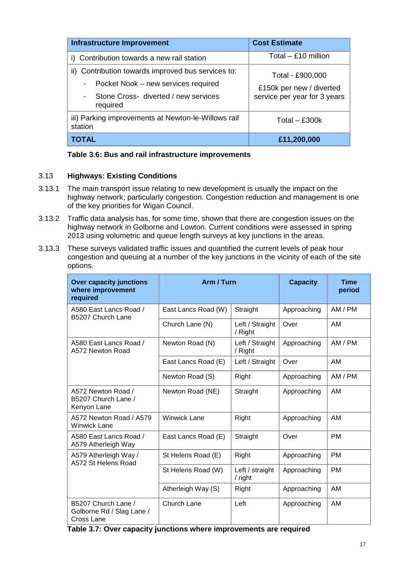
i) Contribution towards a new rail station Total – £10 million
ii) Contribution towards improved bus services to:
- Pocket Nook – new services required
- Stone Cross- diverted / new services required
Total - £900,000
£150k per new / diverted service per year for 3 years
iii) Parking improvements at Newton-le-Willows rail station
Total – £300k
TOTAL £11,200,000
Table 3.6: Bus and rail infrastructure improvements
3.13 Highways: Existing Conditions
3.13.1 The main transport issue relating to new development is usually the impact on the highway network; particularly congestion. Congestion reduction and management is one of the key priorities for Wigan Council.
3.13.2 Traffic data analysis has, for some time, shown that there are congestion issues on the highway network in Golborne and Lowton. Current conditions were assessed in spring 2013 using volumetric and queue length surveys at key junctions in the areas.
3.13.3 These surveys validated traffic issues and quantified the current levels of peak hour congestion and queuing at a number of the key junctions in the vicinity of each of the site options.
Over capacity junctions where improvement required
Arm / Turn Capacity
Time period
East Lancs Road (W) Straight Approaching AM / PM A580 East Lancs Road / B5207 Church Lane
Church Lane (N) Left / Straight / Right
Over AM
Newton Road (N) Left / Straight / Right
Approaching AM / PM
East Lancs Road (E) Left / Straight Over AM
A580 East Lancs Road / A572 Newton Road
Newton Road (S) Right Approaching AM / PM
A572 Newton Road / B5207 Church Lane / Kenyon Lane
Newton Road (NE) Straight Approaching AM
A572 Newton Road / A579 Winwick Lane
Winwick Lane Right Approaching AM
A580 East Lancs Road / A579 Atherleigh Way
East Lancs Road (E) Straight Over PM
St Helens Road (E) Right Approaching PM
St Helens Road (W) Left / straight / right
Approaching PM
A579 Atherleigh Way / A572 St Helens Road
Atherleigh Way (S) Right Approaching AM
B5207 Church Lane / Golborne Rd / Slag Lane / Cross Lane
Church Lane Left Approaching AM
Table 3.7: Over capacity junctions where improvements are required

18
3.13.4 The junctions above are currently operating at or over capacity on one or more arms, and any additional traffic would only exacerbate these problems. The table indicates whether the additional development traffic is likely to have a minor or major impact if further traffic is added to the identified overcapacity turns. The table also indicates which time period (i.e. morning or evening peak hour) the capacity issues occur in.
3.13.5 The impact of traffic generated by the three site options for Golborne and Lowton is expected to be relatively localised; however, the data demonstrates that wherever development is accommodated it will adversely affect the junctions listed above, and particularly junctions along the A580 East Lancashire Road.
3.13.6 A number of capacity improvement options have been installed in recent years, including traffic signal technology (SCOOT) to help with queue management during peak times. Further junction improvements have been investigated at these junctions to facilitate the levels of development required in the Golborne and Lowton areas: those that can be justified and are deemed viable have been included in the highway modelling assessments later in this section.
3.13.7 It is important to recognise that there are other locally known congestion hotpots, however these were not picked up in the assessment work as traffic models looks at average peak hour conditions and can understate the magnitude of shorter duration over-capacity and queuing. For instance, a junction may experience significant queuing for 15 to 20 minutes of the peak hour, but much reduced or no queuing for the remaining 40 to 45 minutes of the hour. The results averaged over the whole hour would suggest that the junction is operating within capacity, whereas for those drivers that pass through the junction in the busiest 15 to 20 minutes, they would perceive that the junction operates over-capacity.
3.13.8 Local knowledge will therefore play a critical part in supporting the evidence and modelling work. This is apparent within this section of the report and needs to be reflected in all transport modelling work for site options in this broad location.
3.13.9 When considering the existing travel demands for peak hour travel (journeys to/from work and school), based upon travel to work data from the 2001 census, the majority of working residents in Golborne and Lowton work within a five mile radius of Golborne and Lowton. The most travelled to destinations outside of Wigan borough are Warrington and St.Helens and it is anticipated that with direct highway connections to key employment areas in Manchester, Trafford and Salford that these areas may well become new employment destinations in association with the housing development in this broad location. Understanding travel patterns and behaviours will be another critical component to minimising the impact of development.
3.13.10 It is important to note that the count information and trip pattern data does not account for any linked trips (people driving to drop children off at breakfast clubs / school then going onto work, or coming home from work and going to the shops or leisure activities first before going home). This linked trip information may provide additional demands on the network with multiple trips through junctions unaccounted and double turning movements. Again, this stresses the importance of ensuring local knowledge is applied to any modelling assessments (which are steered by the data and assumptions input into the system) and modelling evidence is not determined to be definitive in isolation.
3.14 Highway Impact Assessments: Traffic Modelling
3.14.1 Wigan Council appointed Transport for Greater Manchester, Highways Forecasting and Analytical Services (TfGM HFAS) to examine the potential traffic impact of proposed provision of 1,000 residential units in Golborne and Lowton. A local Saturn model of Golborne and Lowton was developed, cordoned from the base year (validation) Wigan LDF Saturn Model. The extent of the cordoned network for Golborne and Lowton is shown in Figure 4.

19
3.14.2 The car trip generation of the sites was estimated using the same TRICS trip rates used for all traffic modelling carried out in support of the development of Wigan’s draft LDF Core Strategy. For the purposes of this work, the trip rates used were for the TRICS site location category, ‘edge of town’, for the TRICS residential land-use category, ‘house privately owned’. We estimated the likely distribution of the trips generated by the proposed development sites using the HFAS Devtrips1 software.
3.14.3 Initially (for simplicity) each development site was assumed to have a single access point onto the network: Pocket Nook site would have access from St Helens Road from Pocket Nook Lane; Stone Cross site would have access from Stone Cross Lane; and Rothwell’s Farm from B5207 Lowton Road. To ensure that all the traffic generated by each site could reach the network, the site access junction was coded into the model with unlimited capacity.
Figure 4: TfGM modelling cordon
3.14.4 Further modelling assumptions include:
• that individual developers would carry out appropriate assessments of their proposed site access arrangements to ensure that they provide sufficient capacity;
• that there will be no growth in background traffic levels; and
• that future traffic growth in the cordoned model areas would be solely due to traffic generated by the proposed development sites.
1 Devtrips: HFAS utility based on observed trip length distributions for various land uses in combination with zonal census data and SATURN model highway costs and routes.

20
3.15 Modelling Scenarios
3.15.1 This section of the report considers the highway impacts associated with different options for splitting the 1,000 units between the three site options. A number of scenarios have been tested to understand the severity of impact on the network as outlined in Table 3.8.
Development Split (units) Scenario Tests Pocket
Nook Rothwell’s
Farm Stone Cross
Notes / Other Assumptions
DM 1 1000 0 0
DM 2 0 500 500
100% allocation assigned to each of the site options to understand the potential levels of impact
DM 3A 1000 0 0
DM 3B 0 600 400
DM 3C 333 333 333
DM 3D 500 250 250
Realistic allocations based on known site capacities and access points
DM 4 150 400 650 Development totals based on known planning applications and submitted pre-application master plans (considered to understand the un-co-ordinated ‘worst case’ scenario)
DS 3A(i - ii) 1000 0 0
DS 3B(i - iii) 0 600 400
DS 3C(i - iv) 333 333 333
DS 3D(i - iv) 500 250 250
DS 3E 200 400 400
DS 4 150 400 650
Developments modelled with various infrastructure scenarios as specified below
Note: DM = Do-Minimum; DS = Do-Something
Table 3.8: Summary of the scenario tests
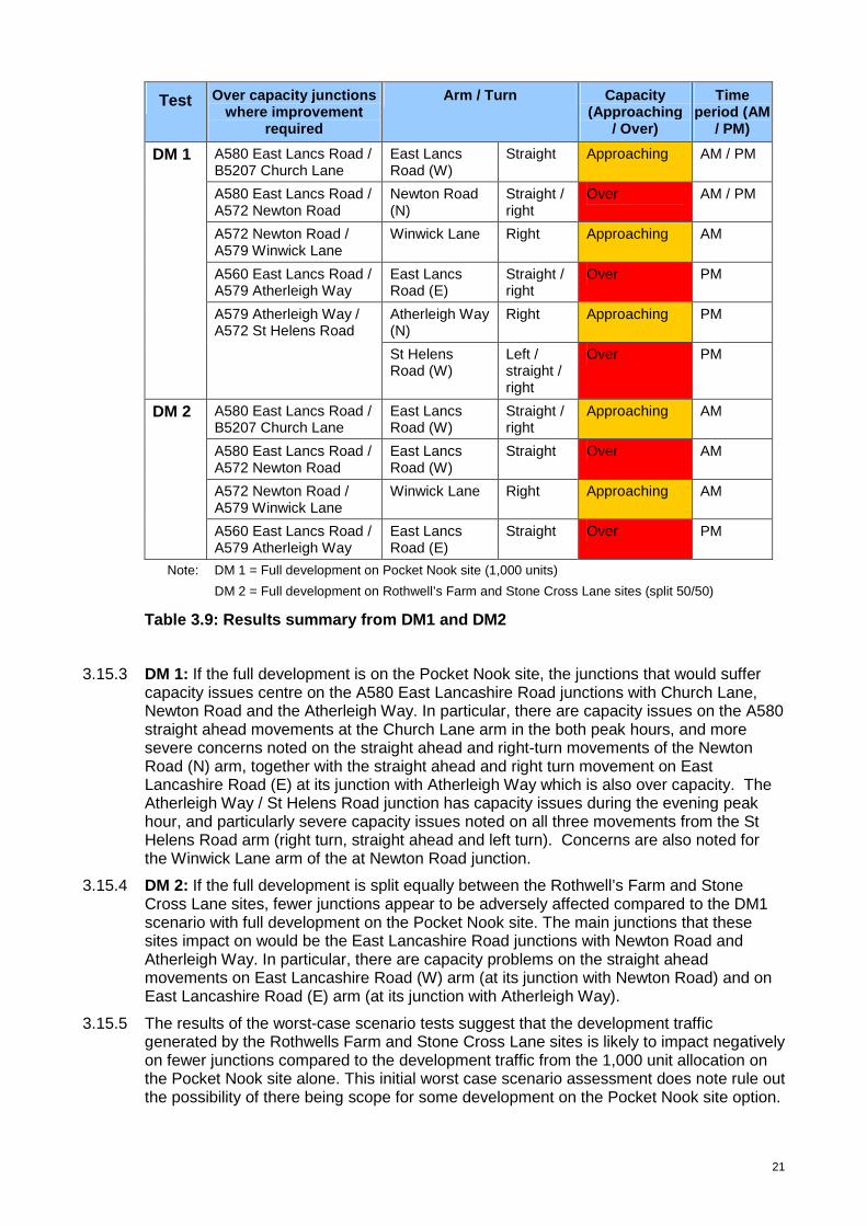
3.15.2 DM 1 & DM 2 Scenarios : These examine the potential worst-case impact of development of all 1,000 units on one site option at Pocket Nook and as this is not possible for the other two sites, the 1,000 units are split equally between Stone Cross and Rothwell’s Farm. This scenario combination will help to identify all potential capacity impacts of the generated traffic. The results are summarised in Table 3.9.
21
Test Over capacity junctions where improvement
required
Arm / Turn Capacity (Approaching
/ Over)
Time period (AM
/ PM)
A580 East Lancs Road / B5207 Church Lane
East Lancs Road (W)
Straight Approaching AM / PM
A580 East Lancs Road / A572 Newton Road
Newton Road (N)
Straight / right
Over AM / PM
A572 Newton Road / A579 Winwick Lane
Winwick Lane Right Approaching AM
A560 East Lancs Road / A579 Atherleigh Way
East Lancs Road (E)
Straight / right
Over PM
Atherleigh Way (N)
Right Approaching PM
DM 1
A579 Atherleigh Way / A572 St Helens Road
St Helens Road (W)
Left / straight / right
Over PM
A580 East Lancs Road / B5207 Church Lane
East Lancs Road (W)
Straight / right
Approaching AM
A580 East Lancs Road / A572 Newton Road
East Lancs Road (W)
Straight Over AM
A572 Newton Road / A579 Winwick Lane
Winwick Lane Right Approaching AM
DM 2
A560 East Lancs Road / A579 Atherleigh Way
East Lancs Road (E)
Straight Over PM
Note: DM 1 = Full development on Pocket Nook site (1,000 units)
DM 2 = Full development on Rothwell’s Farm and Stone Cross Lane sites (split 50/50)
Table 3.9: Results summary from DM1 and DM2
3.15.3 DM 1: If the full development is on the Pocket Nook site, the junctions that would suffer
capacity issues centre on the A580 East Lancashire Road junctions with Church Lane, Newton Road and the Atherleigh Way. In particular, there are capacity issues on the A580 straight ahead movements at the Church Lane arm in the both peak hours, and more severe concerns noted on the straight ahead and right-turn movements of the Newton Road (N) arm, together with the straight ahead and right turn movement on East Lancashire Road (E) at its junction with Atherleigh Way which is also over capacity. The Atherleigh Way / St Helens Road junction has capacity issues during the evening peak hour, and particularly severe capacity issues noted on all three movements from the St Helens Road arm (right turn, straight ahead and left turn). Concerns are also noted for the Winwick Lane arm of the at Newton Road junction.
3.15.4 DM 2: If the full development is split equally between the Rothwell’s Farm and Stone Cross Lane sites, fewer junctions appear to be adversely affected compared to the DM1 scenario with full development on the Pocket Nook site. The main junctions that these sites impact on would be the East Lancashire Road junctions with Newton Road and Atherleigh Way. In particular, there are capacity problems on the straight ahead movements on East Lancashire Road (W) arm (at its junction with Newton Road) and on East Lancashire Road (E) arm (at its junction with Atherleigh Way).
3.15.5 The results of the worst-case scenario tests suggest that the development traffic generated by the Rothwells Farm and Stone Cross Lane sites is likely to impact negatively on fewer junctions compared to the development traffic from the 1,000 unit allocation on the Pocket Nook site alone. This initial worst case scenario assessment does note rule out the possibility of there being scope for some development on the Pocket Nook site option.

22
3.15.6 DM 3A, 3B, 3C & 3D: Following the initial impact assessment, more detailed information about the likely access points for each development site. It is expected that the Pocket Nook and Stone Cross Lane sites would have more than one access point. Including this in the modelling provided a more realistic distribution of the development traffic across the networks. Assumed access arrangements for the Golborne sites were as follows: • Access to the Pocket Nook site would be from Pocket Nook Lane and Atherleigh Way
(near its junction with East Lancashire Road);
• Access to the Stone Cross Lane site would be from Stone Cross Lane and Church Lane;
• Access to the Rothwell’s Farm site would be from Lowton Road only.
3.15.7 For this stage of the impact assessment, the 1,000 units were allocated to the site options based on realistic site capacities as outlined below.
Test Pocket Nook Rothwell’s Farm Stone Cross
3A 1,000 0 0
3B 0 400 600
3C 333 333 333
3D 500 250 250
Table 3.10: Development scenarios with realistic capacities and access points
3.15.8 The results of the DM 3 scenarios are shown in the table below, which highlights the junction arms where the development traffic is expected to contribute towards capacity problems. Junction arms that are forecast to be over-capacity are highlighted in red, while arms that are approaching capacity are highlighted in amber. This table helps to identify which development split would provide the least amount of traffic impact.
3.15.9 The table of results shows that the majority of the capacity issues are in the morning peak hour, while test DM3A (all 1,000 units at Pocket Nook) and DM3D (500 units at Pocket Nook, with the remaining 500 units split equally between Rothwell’s Farm and Stone Cross Lane) appear to have the least impact. This suggests that the additional access point onto Atherleigh Way at the Pocket Nook site would help reduce its impact on the surrounding network.
3.15.10 Tests DM3A and DM3D indicate that the main capacity problem resulting from traffic generated by the Pocket Nook site would be at the A580 East Lancashire Road / Atherleigh Way signalised junction, and in particular, the right-turn from the East Lancashire Road (E) arm which is over-capacity in both the morning and evening peak hours.
Test Impact Over capacity junctions where
improvement required
Arm
DM 3A DM 3B DM 3C DM 3D
East Lancs Road (W)
PM A580 East Lancs Rd / B5207 Church Ln Church Lane (N) AM AM
Newton Road (N) AM/ PM
AM PM A580 East Lancs Rd / A572 Newton Rd East Lancs Road
(E) AM/
PM AM AM/ PM
Kenyon Lane (SE) AM AM AM A572 Newton Rd / B5207 Church Ln / B5207 Kenyon Ln Church Lane (NW) AM
23
A572 Newton Rd / A579 Winwick Ln
Newton Road (W) AM AM
A560 East Lancs Rd / A579 Atherleigh Way
East Lancs Road (E)
AM/ PM
PM AM/ PM
St Helens Rd (W) PM A579 Atherleigh Way / A572 St Helens Rd Atherleigh Way (N) PM PM PM
Note: Red = Over-capacity; Amber = Approaching capacity
Table 3.11: Results summary from DM3A, DM3B and DM3C
3.15.11 The straight-ahead and left-turn movements on the Church Lane (N) arm at its junction with East Lancashire Road are approaching capacity as a result of traffic generated by the Rothwells Farm and Stone Cross Lane sites in Tests DM3B and DM3C. These tests also suggest that if the development split is biased towards Rothwells Farm and Stone Cross Lane, there is a greater detrimental impact at the junctions of East Lancashire Road / Newton Road (straight-ahead movement on the East Lancashire Road (E) arm) and Newton Road / Winwick Lane (right-turn on the Newton Road (W) arm). There are also capacity problems in tests DM3A, DM3B and DM3C on the straight-ahead movement on Kenyon Lane at its junction with Newton Road in the morning peak-hour.
3.15.12 Despite its close proximity to the Stone Cross Lane and Rothwells Farm sites, the Church Lane / Cross Lane / Golborne Road / Slag Lane signalised junction is forecast to operate within capacity during the morning and evening peak hours. Although local knowledge shows that this junction has capacity concerns, during the morning peak hour, particularly due to the clash of commuter journeys and school run trips.
3.15.13 Overall, the development split in scenario DM3D is forecast to have the least impact on the network, as in this scenario the straight-ahead movements on the Newton Road (N) and East Lancashire Road (E) approaches of the East Lancashire Road / Newton Road junction are approaching capacity, along with the right-turn from the Atherleigh Way (N) arm at its junction with St Helens Road. Only the right-turn from the East Lancashire Road (E) approach arm to its junction with Atherleigh Way is over capacity.
3.15.14 Test DM4 considers another ‘worst case’ scenario: the traffic impact of all the known planning applications for developments on parts of the Pocket Nook, Stone Cross and Rothwell’s Farm site options. In this scenario, consideration has been given to level of impact from the considerably higher trip generation created by un-co-ordinated planning approvals.
3.15.15 Current known applications and pre-application interests for these areas total just under 1,200 units:
• 150 units - Pocket Nook (Persimmon)
• 400 units – Rothwell’s Farm (potential development)
• 650 units - Stone Cross Lane (Wainhomes).
3.15.16 Clearly, all the above development applications would generate considerably more trips than the 1,000 units considered in the tests considered earlier in this report. The test results are outlined in Table 3.12.
Test Impact Over capacity junctions where improvement required
Arm
DM 4
East Lancs Road (W) A580 East Lancs Road / B5207 Church Lane
Church Lane (N) AM
Newton Road (N) AM/PM A580 East Lancs Road / A572 Newton Road
East Lancs Road (E) AM
24
Kenyon Lane (SE) AM A572 Newton Road / B5207 Church Lane / B5207 Kenyon Lane Church Lane (NW) AM
A572 Newton Road / A579 Winwick Lane
Newton Road (W) AM
A560 East Lancs Road / A579 Atherleigh Way
East Lancs Road (E) PM
St Helens Rd (W) A579 Atherleigh Way / A572 St Helens Road
Atherleigh Way (N) PM
Note: Red = Over-capacity; Amber = Approaching capacity
Table 3.12: Results summary from DM4
3.15.17 Test DM4 indicates that traffic generated by the known planning applications would have a negative impact on the operation of a number of junctions in the network, particularly in the morning peak hour. More junction arms would be over-capacity compared to any of the DM3 scenarios, suggesting that extensive mitigation measures would be required to alleviate the congestion related to this development scenario.
3.15.18 The modelling of this scenario clearly demonstrates that the significantly higher level of additional traffic generated by all the current planning applications in this area would worsen the capacity problems already identified in the DM3A, DM3B, DM3C and DM3D scenarios.
3.16 Highway Capacity Improvements
3.16.1 All of the analysis reported above considers the impact of the traffic generated by the developments on the existing highway network in the Golborne and Lowton area. However, as mentioned earlier, potential mitigation measures have been investigated to help alleviate some of the junction capacity issues identified. These are listed below. Initial scheme drawings can be seen in Appendix D for a number of these proposed measures.
• New link road through the Pocket Nook development site from A572 Newton Road (via Pocket Nook Lane) and A579 Atherleigh Way (north of its junction with the A580 East Lancashire Road.
• New link road through the Stone Cross Lane development site from Stone Cross Lane to Church Lane.
• Junction improvements at A580 / Stone Cross Lane: widening the Stone Cross Lane (North) arm to create four lanes (two left turn and two right turn lanes)
• Junction improvements at A573/A580: Replacement of the existing roundabout with new traffic signal controls at the A573 Warrington Road / A580 junction.
• Junction improvements along the A580 / B5207 and A572 / B5207: Widening the A580 entry and exit arms in both directions (4 lane gains in total) at its junction with B5207 Church Lane, plus widening on the Church Lane entry arms to its junction with the A580 and A572 Newton Road respectively
• Junction improvements at A580/A572 Newton Road : Widening the A580 entry and exit arms in both directions (4 lane gains in total) at its junction with A572 Newton Road
• Junction improvements at A572/A579: Widening the A572 Newton Road south west approach to its junction with A579 Winwick Lane
• Junction improvements at A572/A579: Widening the A572 / A579 junction at its south west (A572 St.Helens Road) and northern (A579 Atherleigh Way) approaches.
• Lane Head bypass Option 1 – A579/A580 junction to A579 Winwick Lane
• Lane Head bypass Option 2 - A580 (East Lancs Bridge) to A579 Winwick Lane
25
3.16.2 Those potential improvement schemes above that are deemed viable have been added to the scenario tests already examined above (DM 3A, DM 3B, DM 3C, DM 3D), resulting in a set of Do-Something (DS) test scenarios. The Lane Head bypass is considered to be unviable an has therefore not been taken forward into the DS test scenarios. Whilst it would provide reduced congestion, it is not a viable solution due to the significant estimated cost of implementation.
3.16.3 A further scenario was developed DS 3E in recognition of viability concerns with the Pocket Nook link road and potential level of development on this site option. This scenario provides an opportunity to understand the impact from some development on the Pocket Nook site accessed from existing network without the benefit of an internal link road, and with the remaining development allocation being equally assigned between Rothwell’s Farm and Stone Cross.
3.16.4 The set of Do-Something scenarios with the associated combination of mitigation measures are set out in Table 3.13 below.
Test DS3A
1000 PN, 0 SC, 0 RF
DS3B
0 PN, 600 SC, 400 RF
DS3C
333 PN, 333 SC, 333
RF
DS3D
500 PN, 250 SC, 250 RF
DS3E
200 PN, 400 SC, 400 RF
DS4
All existing planning apps
(i)
Junction improvements at: - A580 / B5207 and A572 / B5207; - A580 / A572 Newton Road;
Junction improvements at: - A580 / B5207 and A572 / B5207; - A580 / A572 Newton Road;
Junction improvements at: - A580 / B5207 and A572 / B5207; - A580 / Newton Road;
Junction improvements at: - A580 / B5207 and A572 / B5207; - A580 / Newton Road; and
Junction improvements at: - A580 / B5207 and A572 / B5207; - A580 / A572 Newton Road;
Stone Cross Link Road
- All mitigation measures but without the removal of roundabout at A580 / A573 Warrington Road and replacement with signal controlled junction
(ii)
- As (i) with the Pocket Nook link road
- As (i) with the Stone Cross link road - Junction improvements at Stone Cross Park / A580 (as identified in planning application)
- As (i) with the Stone Cross link road - Junction improvements at Stone Cross Park / A580 (as identified in planning application)
- As (i) with the Stone Cross link road - Junction improvements at Stone Cross Park / A580 (as identified in planning application)
- As test (i) - with the removal of roundabout at A580 / A573 Warrington Road and replacement with signal controlled junction
(iii)
- As (ii) above with the removal of roundabout at A580 / A573 Warrington Road and replacement with signal controlled junction
- As (i) with the Pocket Nook link road
- As (i) with the Pocket Nook link road
(iv) - All measures
above - All measures above
Table 3.13: Do-something (DS) interventions for each scenario test
3.16.5 The results of the DS test scenarios indicate that the mitigation measures provide varying degrees of benefit depending on the combination of development. The improvements at A580 East Lancashire Road / Church Lane largely solve the capacity issues at this junction, while the measures generally improve performance at the East Lancashire Road / Newton Road and Church Lane / Kenyon Lane / Newton Road junctions.
3.16.6 The tests suggest that replacing the East Lancashire Road / Warrington Road roundabout with a signal controlled junction (GMUTC provided advice on the layout and signal staging for this junction) would not alleviate the capacity issues at this junction.

26
3.16.7 The link road through the Pocket Nook site alleviates the capacity problems at the Atherleigh Way / St Helens Road signalised junction in the test scenarios and also reduces the impact of the additional traffic on the Newton Road / East Lancashire Road signalised junction. However, this needs to be balanced against the level of development from a viability justification in order. Capacity problems remain an issue on the Kenyon Lane (SE) arm at its junction with Newton Road in all scenarios except DS3D; Newton Road (W) arm at its junction with Winwick Lane (DS3B, DS3C and DS4); and the right-turn from the East Lancashire Road (E) arm at its junction with Atherleigh Way.
3.16.8 The full set of scenario test results are outlined in Table 3.14 below.
27
Test Impact
DS 3A DS 3B DS 3C DS 3D DS 3E DS 4
Over capacity junctions where
improvement required
Arm
(i) (ii) (i) (ii) (iii) (i) (ii) (iii) (iv) (i) (ii) (iii) (iv) (i) (i) (ii)
A580 East Lancashire Road / Church Lane
Church Lane (N) am am am am
Newton Road (N) am pm am am pm am pm am pm am pm am pm am am pm am pm am am
East Lancashire Road (E)
am pm am pm am pm am pm am pm am pm am am am pm am pm am am pm am pm am pm am pm
A580 East Lancashire Road / A572 Newton Road
Newton Road (S) am am am am am am am am am am am am am am am am
A572 Newton Road / Church Ln / Kenyon Ln
Church Lane (NW) am am am am am am am am am am am am
Newton Road (W) am am am am am am am am am am am am am am
Newton Road (E) am am am am am am am am am am am am am am
A572 Newton Road / A579 Winwick Lane
Winwick Lane am am am am am am am am am am am am am am am am
A580 East Lancashire Road / A579 Atherleigh Way
East Lancashire Road (E)
pm pm am pm am pm pm pm pm pm pm pm pm pm pm pm pm pm
Atherleigh Way (N) pm
Atherleigh Way (S) am pm pm pm pm pm pm pm pm pm pm pm pm pm pm
A579 Atherleigh Way / A572 St Helens Road
St Helens Rd (W) pm
Golborne Road pm pm Church Lane / Golborne Rd / Slag Lane / Cross Lane Church Lane pm pm pm
East Lancashire (West)
am pm am pm am pm am pm pm am pm am pm am pm am pm am pm am pm am pm am pm am pm am pm am pm
Bridge Street am pm am pm am pm am pm am pm am pm am pm am pm am pm am pm am pm am pm am pm am pm am pm am pm
East Lancashire Road (East)
am am am pm am pm am pm
A580 East Lancashire Road / Bridge Street / Warrington Road
Warrington Road pm am pm
Table 3.14: Results summary for do-something scenarios
28
3.16.9 The results of the Golborne and Lowton ‘Do-Something’ tests indicate that the majority of the capacity issues are in the morning peak hour, however the mitigation schemes would provide some improvement in performance at key junctions in the network.
3.16.10 DS3A(i-ii): The results of tests DS 3A(i) and DS 3A(ii) (1000 units on Pocket Nook only) indicate that the improvements at East Lancashire Road / Church Lane and Church Lane / Newton Road would largely alleviate the capacity problems at these junctions. In the morning peak hour, the Newton Road arms are approaching capacity at its junction with East Lancashire Road in both tests, while the right-turn from East Lancashire Road (E) onto Atherleigh Way is over-capacity in the evening peak hour.
3.16.11 DS3A(ii): This test indicates that the Pocket Nook link road would alleviate capacity issues on the Newton Road arms at its junction with East Lancashire Road in the evening peak hour and on all arms of the Newton Road / Winwick Lane junction also in the evening peak hour. The link road would also benefit the Atherleigh Way / St Helens Road junction by removing capacity problems on all arms of this junction.
3.16.12 DS3B(i-iii): The results of tests DS3B(i–iii) (600 units on Stone Cross Lane and 400 units on Rothwells Farm) indicate that generally this development scenario has a greater detrimental impact compared to the DS3A scenarios. In particular, many of the junction arms at East Lancashire Road / Church Lane, East Lancashire Road / Newton Road, Newton Road / Church Lane and Newton Road / Winwick Lane are approaching capacity or over capacity in the morning peak hour, though the majority within capacity in the evening peak hour. The DS3B tests also indicate that with the development concentrated on the Rothwell’s Farm and Stone Cross Lane sites (with no traffic on the Pocket Nook site) capacity problems on the right-turn from East Lancashire Road (E) onto Atherleigh Way in the evening peak hour are reduced.
3.16.13 There are minimal differences in junction performance between the various DS3B scenarios, suggesting that the link road through the Stone Cross Lane site and the improvements at Stone Cross Lane / East Lancashire Road would have a minimal cumulative impact on the performance of the key junctions in this area. Replacing the East Lancashire Road / Warrington Road roundabout with a signal controlled junction also appears to provide no capacity benefits (based on advice from GMUTC). However, it is possible that given more time, GMUTC would be able to produce a signalisation scheme that would provide some capacity benefits.
3.16.14 DS3C(i-iv): The results of the DS3C tests (with 333 units on each of the three sites) are similar to the DS3B tests. The majority of the capacity issues are the same, though the East Lancashire Road / Church Lane junction would operate within capacity in all of the DS3C scenarios. This suggests that the development traffic generated by the Stone Cross Lane and Rothwells Farm sites has a bigger impact on junction performance in this scenario than the traffic generated by the Pocket Nook site.
3.16.15 The DS3C tests indicate that the Pocket Nook link road alleviates capacity problems at the East Lancashire Road / Newton Road and Atherleigh Way / St Helens Road junctions in the evening peak hour. However, introducing the link road pushes the right-turn from East Lancashire Road (E) onto Atherleigh Way over-capacity in the evening peak hour. There are viability justification questions with regards to the deliverability of the link road when development numbers are under 500 units, therefore the business case for progressing this scenario combination option is not favourable.
3.16.16 DS3D(i-iv): The results of the DS3D tests (500 units on Pocket Nook and 250 units each on Stone Cross Lane and Rothwells Farm) are similar to the DS3C tests. However, the tests do suggest that the Pocket Nook link road will alleviate capacity issues at the East Lancashire Road / Newton Road and the Newton Road / Church Lane junctions in the morning peak hour, and the Atherleigh Way / St Helens Road junction in the evening peak hour.

29
3.16.17 DS3E(i): (400 units each on Stone Cross Lane and Rothwells Farm, and 200 units on Pocket Nook) The results of this scenario indicate that the network will operate with fewer capacity issues compared to some of the other test scenarios. The main capacity problems remain in the morning peak hour with a number of turning movements approaching capacity but only two junction arms are over capacity. These include Church Lane (northwest arm) at its junction with Newton Road and the Bridge Street arm of the roundabout with the A580 East Lancashire Road (although no development traffic routes via this arm).
3.16.18 The mitigation measures on the A580 alleviate capacity issues at its junctions with Newton Road and Church Lane, and at the Newton Road / Winwick Lane junction, while the Newton Road / Church Lane / Kenyon Lane junction is operating within capacity on all arms. The Atherleigh Way / St Helens Road junction is operating within capacity due to the proposed mitigation measures here, and the capacity problems on the right-turn from East Lancashire Road into Atherleigh Way are less of an issue in this scenario given the lower number of units on the Pocket Nook development site.
3.16.19 DS4(i-ii): The results of these tests, which represent current planning applications for the sites, show that the junction arms at East Lancashire Road / Church Lane, East Lancashire Road / Newton Road, Newton Road / Church Lane and Newton Road / Winwick Lane would be approaching capacity or over capacity in the morning peak hour. Junction arms at the East Lancashire Road / Atherleigh Way, Atherleigh Way / St Helens Road and Church Lane / Golborne Road would be approaching or over capacity in the evening peak hour. There would be more instances of junction arms being over-capacity in the DS4 scenarios compared to the other DS scenarios, suggesting that extensive mitigation measures would be required to alleviate the capacity issues.
3.16.20 In common with other scenarios examined, replacing the East Lancashire Road / Warrington Road roundabout with a signal controlled junction also appears to provide no improvement in capacity.
3.17 Conclusions: Transport Infrastructure Assessments
3.17.1 The results of this assessment suggest that several junctions would be adversely affected by provision of new residential units on the three site options in the Golborne and Lowton broad location, particularly on the A580 East Lancashire Road at its junctions with Church Lane, Newton Road and Atherleigh Way.
3.17.2 The evidence shows that without interventions there is a bias towards development on the Pocket Nook site option to minimise the impact from transport (scenario DM3D), as there would be less adverse impact on key junctions along the A580 compared to the scenarios where development is focused more on the Stone Cross Lane and Rothwell’s Farm site options.
3.17.3 However, the Pocket Nook site requires the internal link road from St Helens Road / Pocket Nook Lane to the Atherleigh Way in order to minimise the transport impact on the local network. Concerns are noted with regards to the viability of this infrastructure link as there is no evidence of a collective masterplan from developers for this site option. In addition, the proposed high speed rail alignment could limit or restrict the amount of land available to support the levels of development required on this site to justify the infrastructure requirements. Evidence was also presented to the Core Strategy examination suggesting that some of the Pocket Nook Site would not be made available for development.
3.17.4 However, the results of the DS3E scenario shows that, with the combination of mitigation measures (improvements on the A580 at its junctions with Newton Road and Church Lane, the Newton Road / Winwick Lane, Newton Road / Church Lane / Kenyon Lane,
30
and Atherleigh Way / St Helens Road junctions), the network would operate reasonably well with development biased towards the Stone Cross Lane and Rothwell’s Farm site options.
3.17.5 The main capacity problems that will remain are in the morning peak hour with a number of turning movements approaching capacity, but only two junction arms are over capacity. These include Church Lane (northwest arm) at its junction with Newton Road and the Bridge Street arm of the roundabout with the A580 East Lancashire Road (although no development traffic routes via this arm).
3.17.6 The preliminary assessment of a draft junction design suggests that replacing the East Lancashire Road / Warrington Road roundabout with a signal controlled junction would provide no capacity benefits. However, it is possible that given more time, GMUTC would be able to produce a signalisation scheme that would provide some additional capacity benefits.
3.17.7 Taking account of the limitations with the Pocket Nook site and the additional sustainable transport benefits associated with the Rothwell’s Farm and Stone Cross site options, in order to minimise the traffic impact of introducing 1,000 units in the Golborne and Lowton areas, the evidence suggests that the following combination of site options would be most acceptable: 400 homes at Rothwell’s Farm, 400 homes at Stone Cross and 200 homes at Pocket Nook.
3.17.8 The potential exists for a new railway station in Golborne on the West Coast Main Line. This station would be able to take advantage of the new electrification on the Chat Moss Line and the provision of new TransPennine Express services to be introduced from December 2013 between Wigan North Western and Manchester Piccadilly, as well as further afield. The provision of a station would significantly assist with improving public transport connectivity from Golborne for residents and the opportunity for development in the broad location to contribute financially towards its implementation should be considered, subject to viability tests.
31
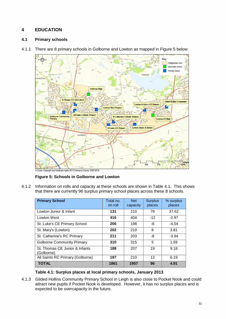
4 EDUCATION 4.1 Primary schools 4.1.1 There are 8 primary schools in Golborne and Lowton as mapped in Figure 5 below.
Figure 5: Schools in Golborne and Lowton
4.1.2 Information on rolls and capacity at these schools are shown in Table 4.1. This shows that there are currently 96 surplus primary school places across these 8 schools.
Primary School Total no.
on roll Net
capacity Surplus places
% surplus places
Lowton Junior & Infant 131 210 79 37.62
Lowton West 416 404 -12 -2.97
St. Luke's CE Primary School 206 198 -8 -4.04
St. Mary's (Lowton) 202 210 8 3.81
St. Catherine's RC Primary 211 203 -8 -3.94
Golborne Community Primary 310 315 5 1.59
St. Thomas CE Junior & Infants (Golborne)
188 207 19 9.18
All Saints RC Primary (Golborne) 197 210 13 6.19
TOTAL 1861 1957 96 4.91
Table 4.1: Surplus places at local primary schools, January 2013
4.1.3 Gilded Hollins Community Primary School in Leigh is also close to Pocket Nook and could attract new pupils if Pocket Nook is developed. However, it has no surplus places and is expected to be overcapacity in the future.

32
4.1.4 Taking into account published admission numbers and projected primary pupil numbers
across each school year, by 2016/17 there is an estimated surplus of 132 places in Golborne and Lowton.
4.1.5 1,000 additional homes would yield in the region of 210 new primary pupils in Golborne
and Lowton. This is derived from a standard assumption that 100 homes will yield 3 additional pupils per school year group, therefore 21 in total. Set against the projected surplus of 132 places in 2016/17, there would be a shortfall of 105 places. This is set out in Table 4.2 below.
R Y1 Y2 Y3 Y4 Y5 Y6 TOTAL Lowton 147 186 152 179 166 184 163 1177 Total admission numbers 180 180 180 180 180 180 167 1247 Surplus places 33 0 28 1 14 0 4 80 Golborne 81 101 104 91 106 107 96 686 Total admission numbers 105 105 105 105 105 105 105 735 Surplus places 24 4 1 14 0 0 9 52 Total Primary Surplus 57 4 29 15 14 0 13 132 Additional places due to development 30 30 30 30 30 30 30 Shortfall due to development 0 26 1 15 16 30 17 105
Source: Birth rate statistics, ONS
Table 4.2: Projected primary pupil numbers 2016/2017 4.1.6 As the projected shortfall in some year groups exceeds 15 places (half form entry), an
additional 1-form entry primary school or equivalent would be needed to address the shortfall. The cost of a new 1-form entry primary school or equivalent provision is estimated at £3 million (excluding land cost).
4.1.7 Developers will be required to contribute towards the provision of these places. To
calculate contributions for education provision the council currently uses the latest DFE cost multipliers published in 2008, reduced by the location factor for Wigan. This currently equates to a cost of £10,664 per primary place. An inflation figure of 3% is then applied. The following equation will therefore be applied to calculate the required financial contribution from each development within the broad location:
[(DFE cost multiplier x Shortfall of places due to devt.) + 3%] x Homes proposed 1000
4.1.8 Based on the existing DFE cost multiplier, this equates to a contribution of £1,351 per
dwelling, subject to inflation. This financial contribution applies at the time the homes are built. At current process around £1.35m would be accrued towards the additional school provision.
4.1.9 Approximately 1.5 hectares would need to be safeguarded for the provision of a new
primary school. The location of the school needs to take into account its potential to become a Community Hub, so its development would be better suited at the heart of the development rather than on the fringe. There should be good access by public transport,

33
walking and cycling, but it would preferably be located not on a main road to reduce vehicle-pedestrian conflict and the impact of parked cars. The site should ideally be flat, unconstrained and enable school field provision on greenfield land
4.2 Secondary schools 4.2.1 Applying the standard formula, it is estimated that 1,000 new homes will yield around 150
secondary pupils in Golborne and Lowton. Both Golborne and Lowton High Schools serve this area. As set out in Table 4.3 below, there is sufficient secondary school capacity, notably at Lowton High School, to address a development of this scale.
Secondary School Total no. on
roll Net capacity
Surplus places
% surplus places
Lowton High School 807 1150 343 29.83
Golborne High School 782 855 73 8.54
Total 1589 2005 416 20.75
Table 4.3: Surplus places at local secondary schools, January 2013
34
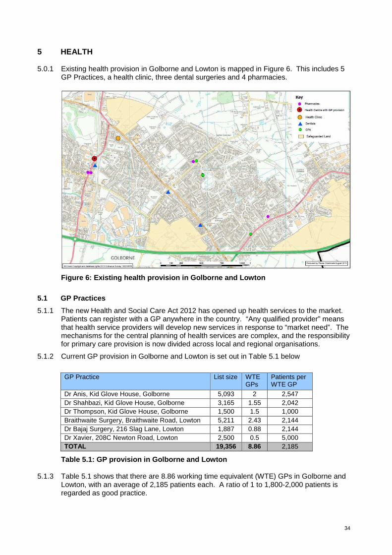
5 HEALTH 5.0.1 Existing health provision in Golborne and Lowton is mapped in Figure 6. This includes 5
GP Practices, a health clinic, three dental surgeries and 4 pharmacies.
Figure 6: Existing health provision in Golborne and Lowton
5.1 GP Practices
5.1.1 The new Health and Social Care Act 2012 has opened up health services to the market. Patients can register with a GP anywhere in the country. “Any qualified provider” means that health service providers will develop new services in response to “market need”. The mechanisms for the central planning of health services are complex, and the responsibility for primary care provision is now divided across local and regional organisations.
5.1.2 Current GP provision in Golborne and Lowton is set out in Table 5.1 below
GP Practice List size WTE
GPs Patients per WTE GP
Dr Anis, Kid Glove House, Golborne 5,093 2 2,547 Dr Shahbazi, Kid Glove House, Golborne 3,165 1.55 2,042 Dr Thompson, Kid Glove House, Golborne 1,500 1.5 1,000 Braithwaite Surgery, Braithwaite Road, Lowton 5,211 2.43 2,144 Dr Bajaj Surgery, 216 Slag Lane, Lowton 1,887 0.88 2,144 Dr Xavier, 208C Newton Road, Lowton 2,500 0.5 5,000 TOTAL 19,356 8.86 2,185
Table 5.1: GP provision in Golborne and Lowton 5.1.3 Table 5.1 shows that there are 8.86 working time equivalent (WTE) GPs in Golborne and
Lowton, with an average of 2,185 patients each. A ratio of 1 to 1,800-2,000 patients is regarded as good practice.

35
5.1.4 GP provision is particularly overstretched in Lowton East. Dr Xavier is the only GP practicing in this area with a list size of approximately 2,500 patients. However, he divides his time between this and his other surgery in Platt Bridge which also has around 2,500 patients. As such, the Lowton surgery is currently significantly overstretched with a ratio of 5,000 per WTE GP.
5.1.5 It is understood however that Dr Xavier intends to practise solely from Lowton in the near future. This will reduce his patient ratio to 1 to 2,500 which is still above good practice levels. Dr Xavier’s surgery operates from a small terraced house and is understood to be significantly below expected NHS standards. There is no scope to expand this practice.
5.1.6 Therefore, if there is substantial development at Pocket Nook (of 400 or more homes), a new replacement GP surgery (with 2 GPs) would be needed. In this case, developers building at the Pocket Nook development site will be required to contribute significantly towards this provision via a Section 106 agreement. Developer contributions could take the form of:
• The provision of sufficient suitable land to accommodate the surgery; and/or
• A financial contribution towards the delivery of the surgery.
5.1.7 If less than 400 homes are developed at Pocket Nook, it is anticipated that the increased demand generated from the development would be absorbed by existing practices in Leigh and Golborne, and therefore no developer contributions would be required towards GP provision in Lowton.
5.1.8 The East of Stone Cross Lane and Rothwells Farm development sites are easily accessible to all surgeries identified in Table 5.2 except Dr Xavier’s. Dr Thompson’s surgery at Kid Glove House Medical Centre in Golborne is a new practice and has only around 1,000 patients per WTE GP. There is sufficient capacity at this practice to accommodate new patients if development is focussed at these two sites.
5.2 Dental surgeries
5.2.1 The 3 dental surgeries in Golborne and Lowton are set out in Table 5.2. Currently dentists can draw their patients from anywhere: there is no geographical restriction.
Dental surgery Address High Street Smiles 107/109 High Street, Golborne, WA3 3BZ Mr J M Kelly and Associates 7a Stonecross Lane, Lowton, WA3 2SA Church Lane Dental Practice 71a Church Lane, Lowton, WA3 2QZ
Table 5.2: Dental surgeries in Golborne and Lowton 5.2.2 The borough has sufficient pharmacies at the moment, and if the market were to grow
there would be no problem attracting new pharmacies to the area.

36
6. OPEN SPACE AND RECREATION
6.1.1 The addition of 1,000 new homes in Golborne and Lowton will have a significant impact on open space and play provision. Existing provision will come under increased pressure and improvements and new open space and recreational facilities will need to be secured. There will need to be provision in the new housing areas, wherever they are located, and the opportunities that those sites offer will need to be maximised. Equally there is a need to consider the green and recreational links between the new housing sites and existing facilities and services. There is also a need to protect and enhance the ecological and biodiversity value of the area. Overall it needs to be considered in a strategic and co-ordinated way.
6.1.2 At a minimum, all development within the broad location will be required to contribute towards the provision of open space and recreation in accordance with saved Unitary Development Plan Policy R1E and the associated Open Space in New Developments Supplementary Planning Document (October 2013).
6.1.3 The policy requires developers of schemes that exceed 99 dwellings to provide a total amount of public open space equivalent to a minimum of 25 sq m per dwelling and a financial contribution in lieu of play equipment provision and to cover commuted maintenance costs. For schemes below 99 dwellings, developers are required to make a financial contribution to the capital and commuted maintenance costs of off-site amenity open space and play space provision proportionate with the number of units in the scheme, in-lieu of on-site provision.
6.1.4 However, because of the significant scale of development, there must be a co-ordinated approach beyond the normal application of planning policy standards and requirements. There are numerous opportunities within and alongside the areas of safeguarded land or elsewhere within Golborne and Lowton, as well as the Greenheart countryside park area adjacent, to which there are existing, or potential strategic links. These would enhance opportunities in the area. Key features are mapped in Figure 7. The level of contribution required in addition to the standard requirement set by Policy R1E will be relevant to the opportunities presented, taking into account the site location, its nature and size as well as reflecting viability constraints.
6.1.5 The key strategic opportunities in Golborne and Lowton include:
• Improvements to provision at Golborne Park / The Bonk • Improved accessibility to Pennington Flash Country Park • Improvements to areas of semi-natural greenspace at Pocket Nook • Designation of a new Local Nature Reserve • Improvements to green corridors and rights of way • Provision for children and young people • Increased allotment provision • Improvements to sports pitch provision
6.1.6 These opportunities are set out in more detail in the remainder of this section. It is not anticipated that developer contributions will enable the delivery of all the opportunities identified. However, it is important that the new developments are integrated effectively and sustainably into the settlement with sustainable access to areas of quality open space, key services and amenities.
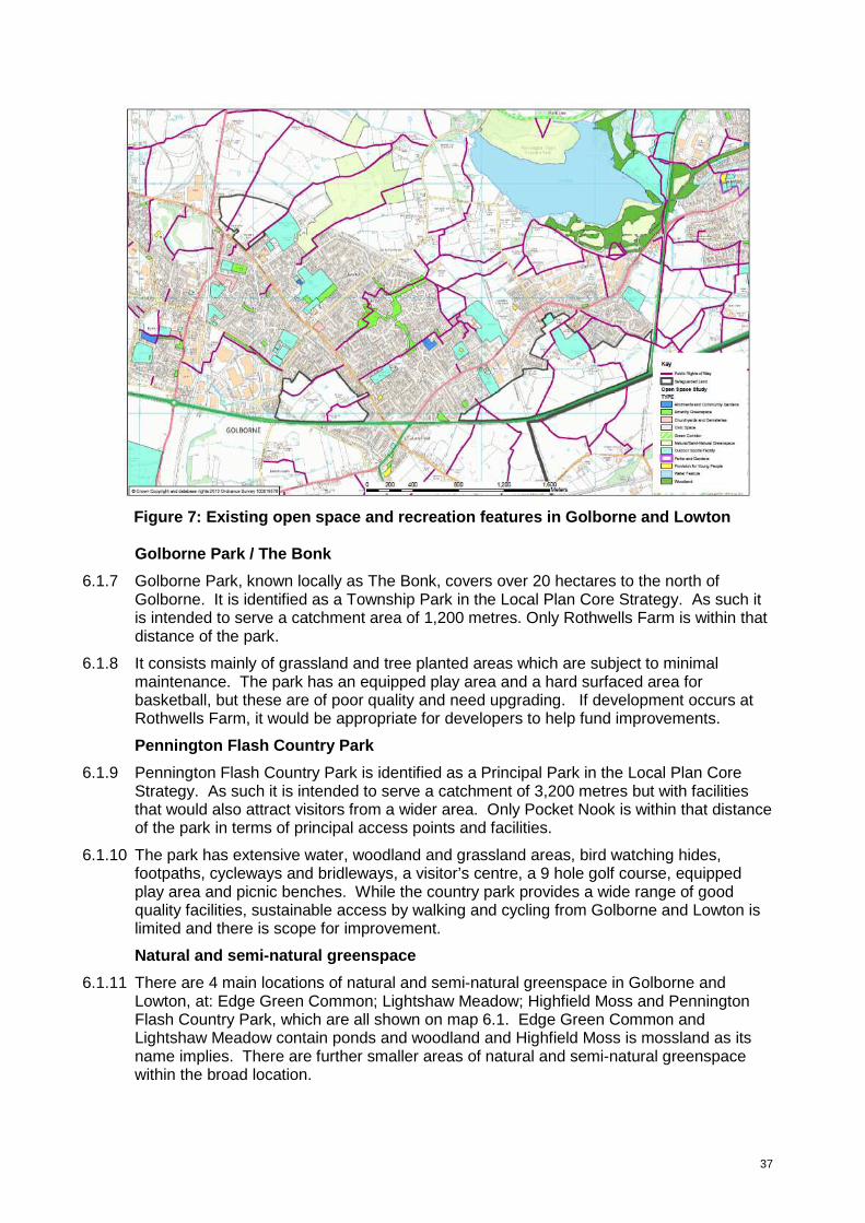
37
Figure 7: Existing open space and recreation features in Golborne and Lowton
Golborne Park / The Bonk
6.1.7 Golborne Park, known locally as The Bonk, covers over 20 hectares to the north of Golborne. It is identified as a Township Park in the Local Plan Core Strategy. As such it is intended to serve a catchment area of 1,200 metres. Only Rothwells Farm is within that distance of the park.
6.1.8 It consists mainly of grassland and tree planted areas which are subject to minimal maintenance. The park has an equipped play area and a hard surfaced area for basketball, but these are of poor quality and need upgrading. If development occurs at Rothwells Farm, it would be appropriate for developers to help fund improvements.
Pennington Flash Country Park
6.1.9 Pennington Flash Country Park is identified as a Principal Park in the Local Plan Core Strategy. As such it is intended to serve a catchment of 3,200 metres but with facilities that would also attract visitors from a wider area. Only Pocket Nook is within that distance of the park in terms of principal access points and facilities.
6.1.10 The park has extensive water, woodland and grassland areas, bird watching hides, footpaths, cycleways and bridleways, a visitor’s centre, a 9 hole golf course, equipped play area and picnic benches. While the country park provides a wide range of good quality facilities, sustainable access by walking and cycling from Golborne and Lowton is limited and there is scope for improvement.
Natural and semi-natural greenspace
6.1.11 There are 4 main locations of natural and semi-natural greenspace in Golborne and Lowton, at: Edge Green Common; Lightshaw Meadow; Highfield Moss and Pennington Flash Country Park, which are all shown on map 6.1. Edge Green Common and Lightshaw Meadow contain ponds and woodland and Highfield Moss is mossland as its name implies. There are further smaller areas of natural and semi-natural greenspace within the broad location.

38
6.1.12 Natural England’s accessibility standards for natural and semi-natural greenspace are for everyone to live no more than 300 metres away from a site of at least 2 hectares. The south of the settlement is not well served and significant development at Pocket Nook should incorporate such provision. Improvements to the Culcheth Linear Park northwards into Lowton along the old railway route provide an opportunity to achieve this whilst improving access to existing provision at Pennington Flash Country Park. Although there are different timescales involved, this needs to be considered in conjunction with the high speed rail proposals.
Local Nature Reserves
6.1.13 Based on the Natural England recommendation of 1 hectare per 1,000 people, there is a boroughwide deficit of Local Nature Reserves totalling 36 hectares. The Core Strategy supports the designation of additional Local Nature Reserves, especially in the east of the borough. In line with the Natural England recommendation, the development of 1,000 homes equates to the provision of an additional 2.4 hectares of Local Nature Reserve. There is scope to designate areas within Pennington Flash Country Park, Lightshaw Meadow and/or Highfield Moss to address this. Contributions to the requirements for Local Nature Reserve status at one of more of these areas may be appropriate.
Green corridors
6.1.14 Culcheth Linear Park runs northwards into the borough through Pocket Nook and Lowton Common and along Lightshaw Lane to the north. There is potential to link the park to Pennington Flash Country Park, Lightshaw Meadow and Byrom Wood, as identified in the council’s Rights of Way Improvement Plan. Another green corridor with potential for improvement links Ashton Road in Golborne with Ashton Heath and southwards along Sandy Lane to the East Lancashire Road. This area contains naturally generated woodland which would benefit from management.
6.1.15 There are also footpaths at each of Rothwell’s Farm, East of Stone Cross Lane and Pocket Nook that have potential for improvement and extension to provide better linkages between key features and settlements. Development should be well connected to the existing (or diverted) rights of way network to give safe walking and cycling routes to key destinations within Golborne and Lowton and beyond. Provision of signposting and way marking and management will be required as appropriate.
Provision for children and young people
6.1.16 Provision for children and young people in Golborne and Lowton includes a neighbourhood equipped area for play and a multi-use games area at Golborne Park and local equipped areas for play at Oaklands Road, Sovereign Close and Heywood Avenue. This provision ensures that all existing residential areas are within 500 metres of local provision or within 1,000 metres of neighbourhood provision, in accordance with good practice. Developments within the broad location will need to contribute towards the provision of play equipment in accordance with saved policy R1E of the Wigan Unitary Development Plan and the Open Space in New Developments Supplementary Planning Document, as stated at paragraph 6.1.2 above.
Allotments
6.1.17 There are 22 statutory allotment plots at Fir Tree Avenue, Lowton and 5 non-statutory plots at Edge Green Lane, Golborne. In addition, there is private allotment provision at Rivington Avenue (about 6 plots) and Thomas Street (about 31 plots) in Golborne. These are mapped at Figure 7.
6.1.18 The Wigan Allotment Strategy sets a target of achieving 9.4 plots per 1,000 households. Against that target there is a deficit locally. In accordance with the target, 1,000 homes will generate the need for an additional 2,350sqm of allotment provision (based on a plot size of 250 sqm). This should be provided in one location as a new site. Developers will
39
be required to provide allotments on-site or make a financial contribution towards this provision. This level of provision is estimated to cost in the region of £30,000. Therefore developers who do not provide on-site allotment provision will be required to contribute £30 per dwelling.
Outdoor sports facilities
6.1.19 Saved policy C1B of the Wigan Unitary Development Plan sets local standards for the provision of football and rugby pitches in the borough as follows:
Pitch size Football Rugby Mini 1 per 14,000 population 1 per 15,000 population Junior 1 per 5,500 population 1 per 14,000 population Senior 1 per 4,500 population 1 per 9,000 population
6.1.20 Existing pitch provision in Golborne and Lowton consists of:
• 2 senior football pitches and a senior rugby pitch at Lowton High School • 1 senior football pitch and a 2 senior rugby pitches at Golborne High School • 1 senior football pitch and 4 senior rugby pitches at Golborne Parkside ARLFC • 2 senior football pitches at Legh Street, Golborne • 1 senior football pitch at Golborne Sports and Social Club • 1 senior, 1 junior and 2 mini football pitches at Hesketh Meadow • 1 senior rugby pitch at Lowton J&I Primary • 1 junior football pitch at Gilded Hollins Primary
6.1.21 There are also mini and junior pitches at a number of other primary schools, however
these are not accessible to the public and therefore do not contribute towards the standards.
6.1.22 Based upon the local standards above, there is an overall surplus of 2.2 pitches in Golborne and Lowton to meet the needs of the existing population of 24,531, and a surplus of 0.5 pitches against the projected need following the development of 1,000 homes. This is set out in Table 6.1 below. It is assumed that 1,000 new households will generate an additional population of 2,400 new people (2.4 per household).
Pitch size Surplus / deficit
Need based on existing
population
Need based on projected population
Current provision
Current population
Future population
Football Mini 1.8 1.9 2 0.2 0.1 Junior 4.5 4.9 2 -2.5 -2.9 Senior 5.5 6.0 8 2.5 2.0 Rugby Mini 1.6 1.8 0 -1.6 -1.8 Junior 1.8 1.9 0 -1.8 -1.9 Senior 2.7 3.0 8 5.3 5.0 Combined total 18 20 20 2.2 0.5
Table 6.1: Quantitative assessment of playing pitch needs in Golborne and Lowton 6.1.23 Table 6.1 shows that there is in fact a surplus of 5 senior rugby and 2 senior football
pitches, but a deficit of mini and junior rugby and junior football pitches. These deficits could be partly addressed by remarking existing senior pitches to accommodate mini and junior sports.
40
6.1.24 A number of the existing pitches are in poor condition and do not meet current sporting needs, particularly at Lowton High, Parkside ARLFC, Legh Street and Hesketh Meadow. The poor condition of these pitches is predominantly as a result of poor drainage. Improving the quality of these pitches is a priority and developer contributions will be focused towards this accordingly.
6.1.25 The estimated cost of undertaking these improvements and the financial contribution that will be required from developers is set out in Table 6.2 below. The required financial contribution from developers is based on the developer contributing 8.9% towards these overall improvements. This is the anticipated increase in population in Golborne and Lowton as a result of the development of 1,000 homes.
Required from developer Improvement Current pitch condition
Estimated cost to improve Total* Per dwelling
3 pitches at Lowton High School Poor £150,000 £13,350 £13.35 5 pitches at Parkside ARLFC Poor £250,000 £22,250 £22.25 2 pitches at Legh Street Poor £100,000 £8,900 £8.90 4 pitches at Hesketh Meadow Poor £200,000 £17,800 £17.80 1 pitch at Lowton J&I Primary Poor £50,000 £4,450 £4.45 1 pitch at Gilded Hollins Primary Poor £50,000 £4,450 £4.45 3 pitches at Golborne High Adequate £150,000 £13,350 £13.35 1 pitch at Golborne Sport & Social Adequate £50,000 £4,450 £4.45 Total £1,000,000 £89,000 £89 *The total cost required from the developer equates to 8.9% of the total cost of the required pitch improvements
Table 6.2: Estimated cost of required playing pitch improvements
6.1.26 This identifies a required financial contribution of £89 per dwelling from developers towards the identified pitch improvements.
6.1.27 Other outdoor sports facilities include one private cricket pitch and 4 private bowling greens and other private sports pitches. It is considered that these facilities are sufficient to meet current and future requirements.
6.1.28 We are currently undertaking a qualitative assessment of open space in the borough, including playing pitches. This assessment will be completed to inform the Allocations Development Plan Document. The findings of the assessment could have an impact on the contributions sought from developers towards playing pitch provision.

41
7 COMMUNITY INFRASTRUCTURE
7.1 There are three existing community centres in Golborne and Lowton with a primary community purpose. These are:
• Church Lane Community Centre, 243 Church Lane, Lowton
• Lowton Youth and Community Centre, Newton Road, Lowton
• Golborne Linc Centre, Worsley Street, Golborne
7.2 The Church Lane Community Centre is a small unit with just 1 room for community use. It is run by the Douglas Valley Partnership and is home to the Golborne Brass Band. It hosts a wide range of community events and organisations including karate, yoga and slimming world. The community centre has an uncertain future due to funding issues.
7.3 Lowton Youth and Community Centre is a privately run facility with four rooms for community use, with front and side gardens. To the rear is a fenced, floodlit hard sports court. Being on one level, it has disabled access and toilets. It is used predominantly by youth and disabled groups and also by the Lowton Operatic and Dramatic Society. The building however is old and would benefit from general maintenance and improvement, particularly to improve its appearance and energy efficiency. The roof is in need of repair and is partly asbestos. Disabled access to the centre could also be improved, as could the gardens.
7.4 Golborne Linc is a privately owned community centre in Golborne town centre with rooms for community use. This was widely used by groups and organisations but unfortunately is about to close due to a lack of funding.
7.5 In addition to these community centres, there is a wide and diverse range of other facilities which provide rooms or services for community use such as schools, churches and Golborne Library.
Schools and children’s centres
7.6 As set out in section 5, there are 8 primary schools (2 with children’s centres) and 2 high schools in the settlement. 2 of the primary schools have Sure Start Children’s Centres (Golborne Community and Lowton J&I). The Children’s Centres and the high schools particularly provide for a wide range of community events and activities.
Places of Worship
7.7 There are 11 places of worship:
• All Saints Roman Catholic Church, High Street, Golborne • Golborne Baptist Church, Charles Street, Golborne • Golborne Congregational Church, High Street, Golborne • Lowton Road Methodist Church, Lowton Road, Golborne • Heath Street Methodist Church, Heath Street, Golborne • St Thomas Church of England, Church Street, Golborne • Lowton Independent Methodist Church, Newton Road, Lowton • Lowton St Marys Church of England, Newton Road, Lowton • Methodist Church, Lane Head, Newton Road, Lowton • St Luke Church of England, Slag Lane, Lowton • St Catherine of Sienna Roman Catholic Church, Newton Road, Lowton – closed at
present due to building condition
7.8 Many of these churches have facilities available for community use, including the following church halls:

42
• All Saints Social Centre, High Street, Golborne • Heath Street Methodist Church Hall, Golborne • St Thomas’ Church Hall, Church Street, Golborne • Lowton St Mary’s Church of England. Newton Road, Lowton
7.9 These church halls are valuable community facilities which are widely used by community and voluntary groups. However, they are maintained on tight budgets and are in need of varying levels of general maintenance, including roof repairs, improved car parking provision, modernisation of kitchen facilities etc. The All Saints Social Centre has poor vehicular and pedestrian access from the main road.
Library
7.10 There is one library at Tanners Lane, Golborne. This provides a community room and promotes community services and events.
Other facilities
7.11 There are also many independently run facilities which have an incidental community use or an associated recreational use that provide a room or rooms for community use or functions and otherwise provide a community service. These include a range of pubs, social clubs, sports clubs and resident centres, including:
• Lowton Labour Club, Newton Road • Golborne Parkside Sports and Social Club, Rivington Avenue, Golborne • Golborne Sports and Social Club, Stone Cross Lane, Lowton • Lowton Civic Hall, Hesketh Meadows Lane, Lowton • Compassion in Action, Oaklands Road
7.12 These facilities are located across the settlement and are mapped in Figure 8.
Figure 8: Community facilities in Golborne and Lowton
7.13 Quantitatively, community provision in Golborne and Lowton is well provided for with a wide range of facilities available as identified above. However, a number of these

43
facilities are managed and maintained independently by the community who have limited access to funding for general upkeep and maintenance. Given that the new developments will increase the demand for these facilities, developers will be required to make a financial contribution of £100 per dwelling to support the improvement and maintenance of community provision in Golborne and Lowton. This will help to sustain community infrastructure in the locality and maintain a sufficient community offer. The financial contribution will be ring fenced into a delivery fund and will be spent on projects such as general maintenance and repair of community buildings as appropriate.

44
8. UTILITIES INFRASTRUCTURE
8.1 Water
8.2 There is sufficient water infrastructure surrounding both the Rothwells Farm and Pocket Nook sites that will support development, but there will be a requirement for minimal intervention depending on point of connection. The security of the water supply in the Stone Cross Lane area is however presently at risk until there is investment in local infrastructure.
8.3 Sewerage
8.4 At Rothwells Farm it would be logical to take gravity flows into the Mill Lane tank but there is currently no infrastructure in place.
8.5 Pocket Nook Lane is served by Canon Sewer which connects to Lately Common pumping station. Prior to development at Pocket Nook there is a need to check the effect at the pumping station but there is possibly capacity for foul-only flows.
8.6 The Stone Cross Lane site is served by Lowton Heath pumping station and there is sufficient capacity to accommodate growth in this area.
8.7 Gas
8.8 It is unlikely that any extra growth in the broad location will create capacity issues for National Grid. The existing transmission networks should be able to cope with additional demands.
8.9 Electricity
8.10 There is spare capacity available at each of the sites, as at 2011/12.
8.11 Summary
8.12 In summary, there is sufficient capacity in both the gas and electricity network to serve development at any of the 3 sites. Investment in water infrastructure is required to support development at Stone Cross Lane and investment in sewerage infrastructure is potentially needed to support development at Rothwell’s Farm and Pocket Nook.
45
9. CONCLUSIONS
9.1 The assessment has concluded that the impact of development on the local transport network, including highways, public transport and walking and cycling, is the most fundamental consideration when determining how development should be distributed across Golborne and Lowton. The impacts on other elements of infrastructure are less geographical specific and do not change fundamentally wherever development is located within the broad location.
9.2 Section 3 confirms that, in transport terms, development would be most acceptable if distributed with around 400 homes at Rothwells Farm, around 400 homes at Stone Cross Lane and around 200 homes at Pocket Nook (Test DS3E). This is subject to the provision of significant new transport interventions delivered by the developments or by financial contributions from the developers as appropriate. Evidence indicates that this combination would maximise the sustainable transport benefits associated with the Rothwell’s Farm and Stone Cross site options.
9.3 Based on this pattern of distribution, the assessment indicates that the following mitigation measures will be required to minimise the impact of the developments on the local transport network:
• Junction improvements at the A580/B5207 and A572/B5207
• Junction improvements at the A580 / A572 Newton Road
• New link road through the Stone Cross Lane development site from Stone Cross Lane to Church Lane.
• New and improved walking and cycling infrastructure
• New and improved bus and rail infrastructure
9.4 Most infrastructure requirements other than transport can be met through financial contributions based upon the number of homes proposed (a cost per dwelling). They are not influenced by where in Golborne and Lowton development will take place. Examples include contributions towards education, health and community provision.
9.5 In terms of open space this assessment has identified some particular local priorities which may be opportunities for investment dependent on where development takes place. A number of these opportunities have the potential to be incorporated into schemes such as investment in Golborne Park as part of development at Rothwells Farm.
9.6 The impact of development on the landscape, settlement pattern and urban sprawl are other key determining factors when considering planning applications. Development should, as far as possible, be contiguous and well integrated with the existing built-up area. For example, development at Pocket Nook should be developed north to south with minimal gaps in the built form. The overall development should be built in a coordinated and strategic manner, with each separate development contributing to the whole effectively. Developers need to work together to achieve this. Detached and disconnected proposals will not be acceptable.
9.7 Other non-infrastructure related factors which will influence decisions on planning applications include:
• Site hazards and constraints including Tree Preservation Orders; ecological factors, areas at risk of flooding; the need to preserve the “best and most versatile” agricultural land; and contamination
• The merit of individual schemes and proposals, in terms of design, layout, density, amenity and community benefits associated with them

46
• The ability of the development to provide sustainable urban extensions to Golborne and Lowton.
9.8 Section 106 contributions will be sought from developers to ensure that the necessary infrastructure mitigation can be provided. Some elements within the sites will come forward as part of development proposals as that development takes shape such as the necessary estate roads through a particular development. Other, mainly off site or strategic works (e.g. open space improvement) will need to be provided through applying a section 106 contribution requirement to the individual developments based upon a rate per house.
9.9 The table in Appendix A provide a list of infrastructure works referred to in this assessment. Some of these works are such that a pro-rata contribution per dwelling will be required. Most transport infrastructure and all of the education contribution are in this category. Other contributions will be sought, and drawn from the list, depending upon size, location and nature of the proposal.
9.10 A worked example is also included at Appendix B. This is indicative only and relates to just one scenario (400 homes at Rothwells Farm, 400 homes at Stone Cross Lane and 200 homes at Pocket Nook). It takes some pro-rata contributions and draws some other infrastructure works considered to be necessary for that particular scheme. Although purely an example, the calculation indicates a cost per dwelling of £6,325-£6,775 depending on which specific site in the broad location was the subject of development.
9.11 The worked example is illustrated at Appendix C. The development areas shown are indicative only and do not reflect the specific boundaries of submitted or anticipated planning applications.
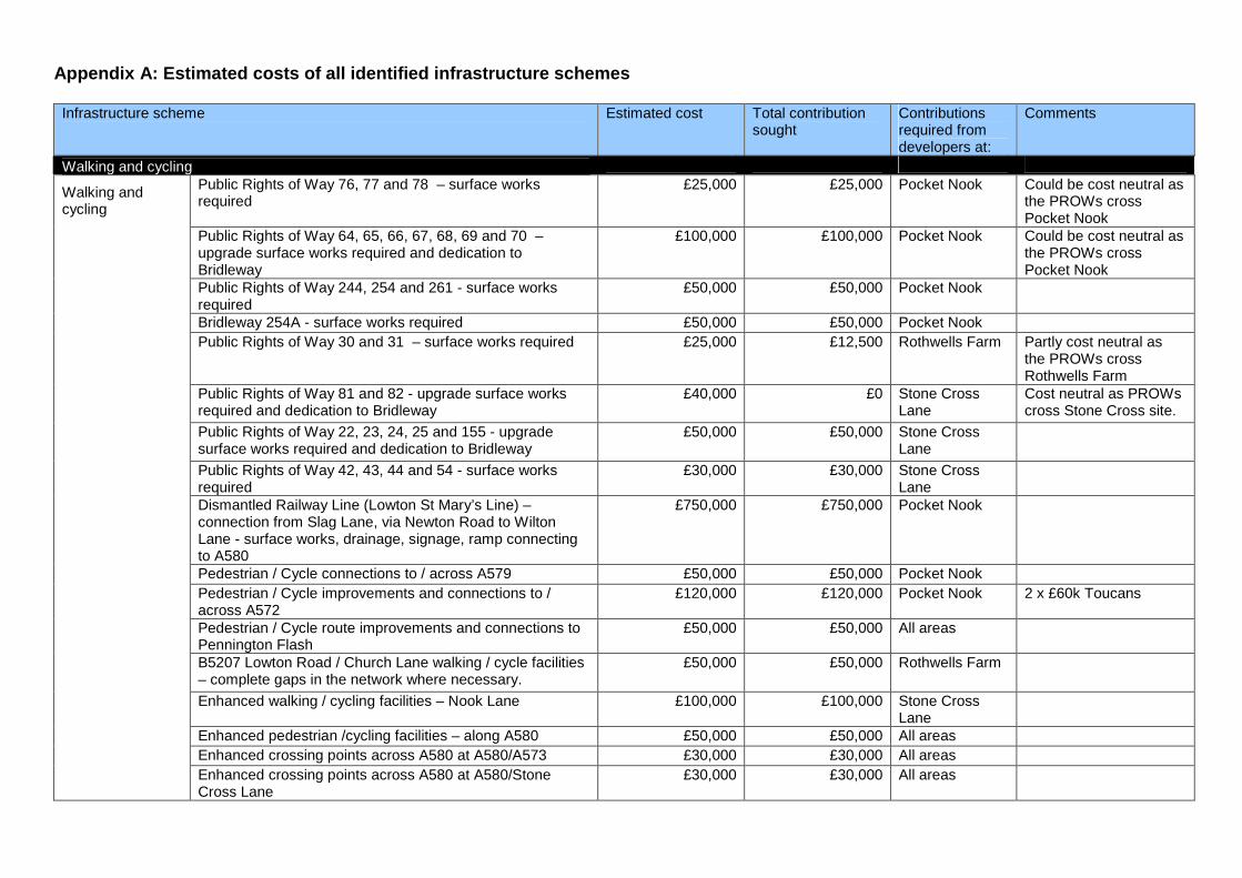
Appendix A: Estimated costs of all identified infrastructure schemes
Infrastructure scheme
Estimated cost Total contribution sought
Contributions required from developers at:
Comments
Walking and cycling Public Rights of Way 76, 77 and 78 – surface works required
£25,000 £25,000 Pocket Nook Could be cost neutral as the PROWs cross Pocket Nook
Public Rights of Way 64, 65, 66, 67, 68, 69 and 70 – upgrade surface works required and dedication to Bridleway
£100,000 £100,000 Pocket Nook Could be cost neutral as the PROWs cross Pocket Nook
Public Rights of Way 244, 254 and 261 - surface works required
£50,000 £50,000 Pocket Nook
Bridleway 254A - surface works required £50,000 £50,000 Pocket Nook Public Rights of Way 30 and 31 – surface works required £25,000 £12,500 Rothwells Farm Partly cost neutral as
the PROWs cross Rothwells Farm
Public Rights of Way 81 and 82 - upgrade surface works required and dedication to Bridleway
£40,000 £0 Stone Cross Lane
Cost neutral as PROWs cross Stone Cross site.
Public Rights of Way 22, 23, 24, 25 and 155 - upgrade surface works required and dedication to Bridleway
£50,000 £50,000 Stone Cross Lane
Public Rights of Way 42, 43, 44 and 54 - surface works required
£30,000 £30,000 Stone Cross Lane
Dismantled Railway Line (Lowton St Mary’s Line) – connection from Slag Lane, via Newton Road to Wilton Lane - surface works, drainage, signage, ramp connecting to A580
£750,000 £750,000 Pocket Nook
Pedestrian / Cycle connections to / across A579 £50,000 £50,000 Pocket Nook Pedestrian / Cycle improvements and connections to / across A572
£120,000 £120,000 Pocket Nook 2 x £60k Toucans
Pedestrian / Cycle route improvements and connections to Pennington Flash
£50,000 £50,000 All areas
B5207 Lowton Road / Church Lane walking / cycle facilities – complete gaps in the network where necessary.
£50,000 £50,000 Rothwells Farm
Enhanced walking / cycling facilities – Nook Lane £100,000 £100,000 Stone Cross Lane
Enhanced pedestrian /cycling facilities – along A580 £50,000 £50,000 All areas Enhanced crossing points across A580 at A580/A573 £30,000 £30,000 All areas
Walking and cycling
Enhanced crossing points across A580 at A580/Stone Cross Lane
£30,000 £30,000 All areas
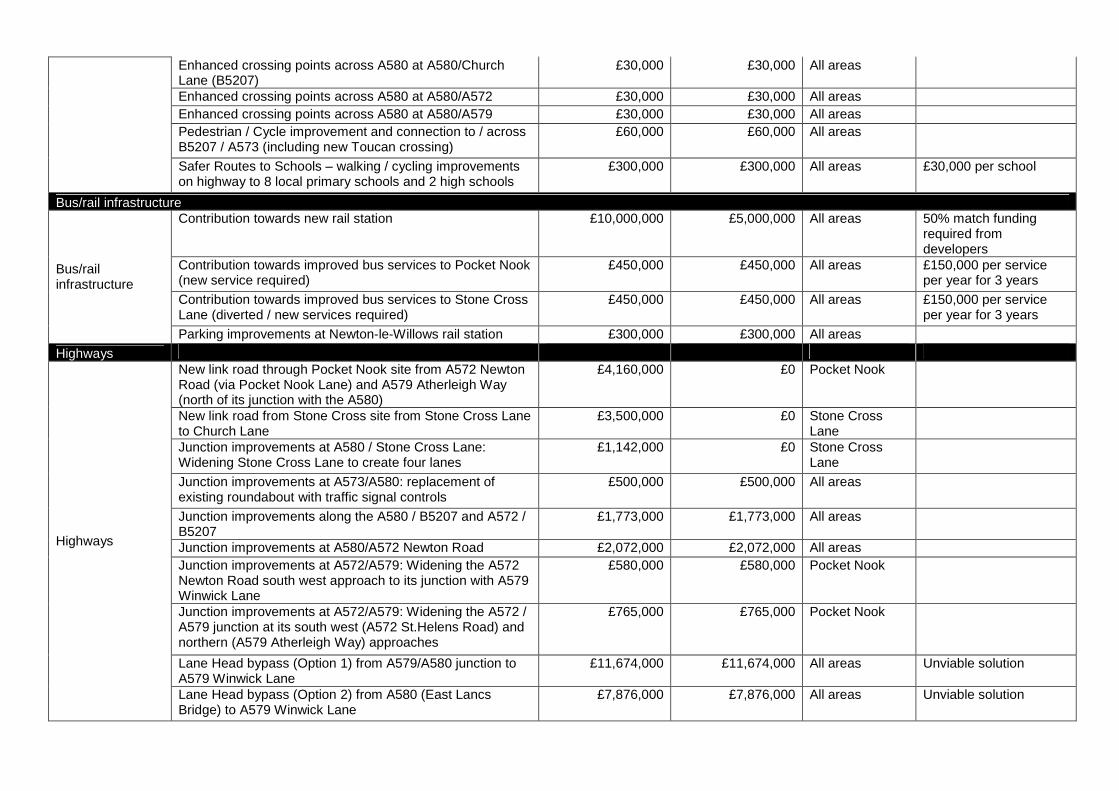
Enhanced crossing points across A580 at A580/Church Lane (B5207)
£30,000 £30,000 All areas
Enhanced crossing points across A580 at A580/A572 £30,000 £30,000 All areas Enhanced crossing points across A580 at A580/A579 £30,000 £30,000 All areas Pedestrian / Cycle improvement and connection to / across B5207 / A573 (including new Toucan crossing)
£60,000 £60,000 All areas
Safer Routes to Schools – walking / cycling improvements on highway to 8 local primary schools and 2 high schools
£300,000 £300,000 All areas £30,000 per school
Bus/rail infrastructure Contribution towards new rail station £10,000,000 £5,000,000 All areas 50% match funding
required from developers
Contribution towards improved bus services to Pocket Nook (new service required)
£450,000 £450,000 All areas £150,000 per service per year for 3 years
Contribution towards improved bus services to Stone Cross Lane (diverted / new services required)
£450,000 £450,000 All areas £150,000 per service per year for 3 years
Bus/rail infrastructure
Parking improvements at Newton-le-Willows rail station £300,000 £300,000 All areas
Highways New link road through Pocket Nook site from A572 Newton Road (via Pocket Nook Lane) and A579 Atherleigh Way (north of its junction with the A580)
£4,160,000 £0 Pocket Nook
New link road from Stone Cross site from Stone Cross Lane to Church Lane
£3,500,000 £0 Stone Cross Lane
Junction improvements at A580 / Stone Cross Lane: Widening Stone Cross Lane to create four lanes
£1,142,000 £0 Stone Cross Lane
Junction improvements at A573/A580: replacement of existing roundabout with traffic signal controls
£500,000 £500,000 All areas
Junction improvements along the A580 / B5207 and A572 / B5207
£1,773,000 £1,773,000 All areas
Junction improvements at A580/A572 Newton Road £2,072,000 £2,072,000 All areas Junction improvements at A572/A579: Widening the A572 Newton Road south west approach to its junction with A579 Winwick Lane
£580,000 £580,000 Pocket Nook
Junction improvements at A572/A579: Widening the A572 / A579 junction at its south west (A572 St.Helens Road) and northern (A579 Atherleigh Way) approaches
£765,000 £765,000 Pocket Nook
Lane Head bypass (Option 1) from A579/A580 junction to A579 Winwick Lane
£11,674,000 £11,674,000 All areas Unviable solution
Highways
Lane Head bypass (Option 2) from A580 (East Lancs Bridge) to A579 Winwick Lane
£7,876,000 £7,876,000 All areas Unviable solution
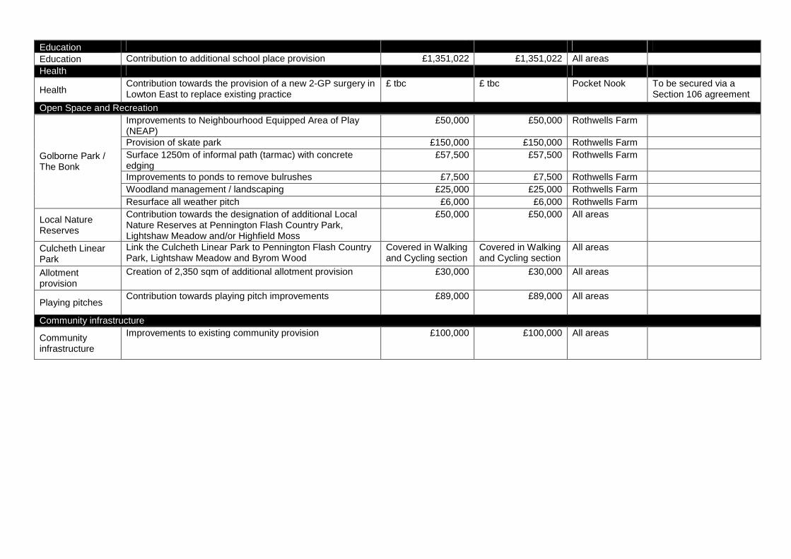
Education Education Contribution to additional school place provision £1,351,022 £1,351,022 All areas Health
Health Contribution towards the provision of a new 2-GP surgery in Lowton East to replace existing practice
£ tbc £ tbc Pocket Nook To be secured via a Section 106 agreement
Open Space and Recreation Improvements to Neighbourhood Equipped Area of Play (NEAP)
£50,000 £50,000 Rothwells Farm
Provision of skate park £150,000 £150,000 Rothwells Farm Surface 1250m of informal path (tarmac) with concrete edging
£57,500 £57,500 Rothwells Farm
Improvements to ponds to remove bulrushes £7,500 £7,500 Rothwells Farm Woodland management / landscaping £25,000 £25,000 Rothwells Farm
Golborne Park / The Bonk
Resurface all weather pitch £6,000 £6,000 Rothwells Farm
Local Nature Reserves
Contribution towards the designation of additional Local Nature Reserves at Pennington Flash Country Park, Lightshaw Meadow and/or Highfield Moss
£50,000 £50,000 All areas
Culcheth Linear Park
Link the Culcheth Linear Park to Pennington Flash Country Park, Lightshaw Meadow and Byrom Wood
Covered in Walking and Cycling section
Covered in Walking and Cycling section
All areas
Allotment provision
Creation of 2,350 sqm of additional allotment provision £30,000 £30,000 All areas
Playing pitches Contribution towards playing pitch improvements £89,000 £89,000 All areas
Community infrastructure
Community infrastructure
Improvements to existing community provision £100,000 £100,000 All areas
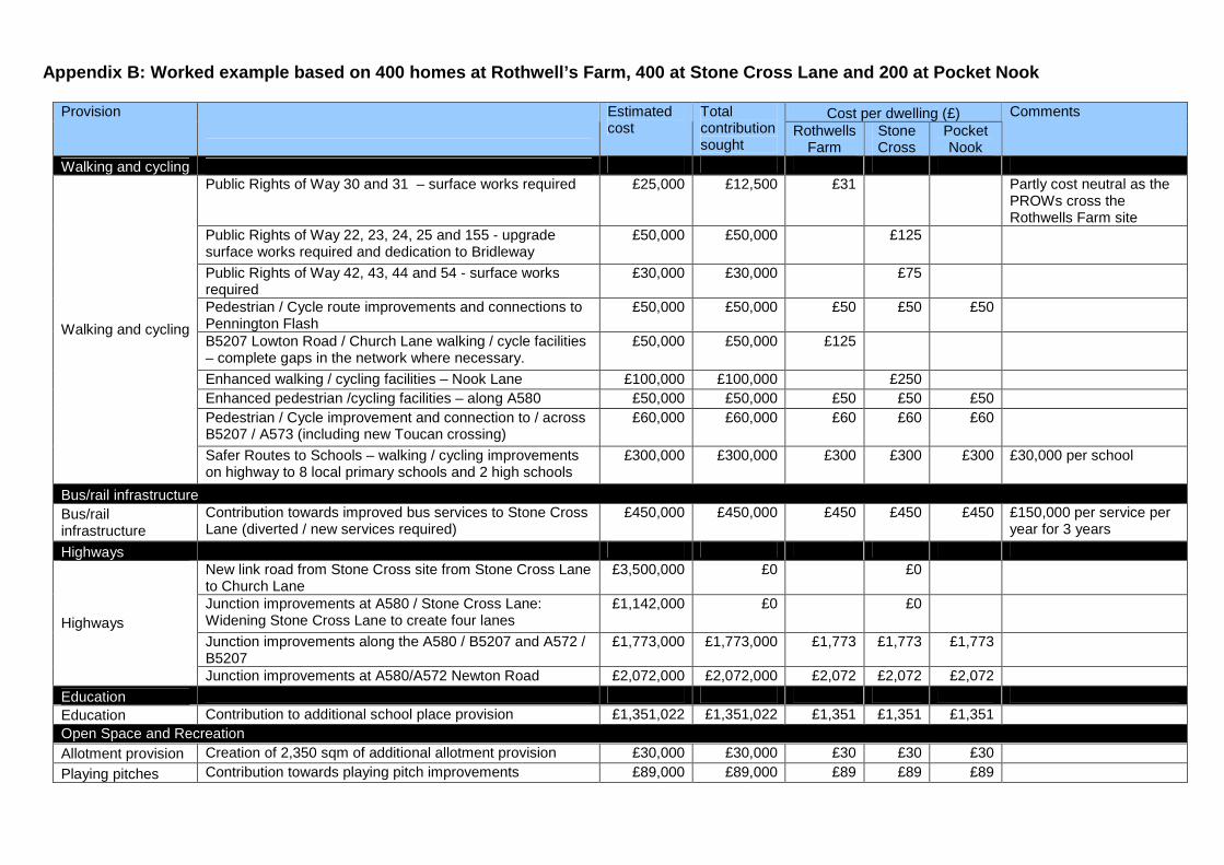
Appendix B: Worked example based on 400 homes at Ro thwell’s Farm, 400 at Stone Cross Lane and 200 at P ocket Nook
Cost per dwelling (£) Provision
Estimated cost
Total contribution sought
Rothwells Farm
Stone Cross
Pocket Nook
Comments
Walking and cycling Public Rights of Way 30 and 31 – surface works required £25,000 £12,500 £31 Partly cost neutral as the
PROWs cross the Rothwells Farm site
Public Rights of Way 22, 23, 24, 25 and 155 - upgrade surface works required and dedication to Bridleway
£50,000 £50,000 £125
Public Rights of Way 42, 43, 44 and 54 - surface works required
£30,000 £30,000 £75
Pedestrian / Cycle route improvements and connections to Pennington Flash
£50,000 £50,000 £50 £50 £50
B5207 Lowton Road / Church Lane walking / cycle facilities – complete gaps in the network where necessary.
£50,000 £50,000 £125
Enhanced walking / cycling facilities – Nook Lane £100,000 £100,000 £250 Enhanced pedestrian /cycling facilities – along A580 £50,000 £50,000 £50 £50 £50 Pedestrian / Cycle improvement and connection to / across B5207 / A573 (including new Toucan crossing)
£60,000 £60,000 £60 £60 £60
Walking and cycling
Safer Routes to Schools – walking / cycling improvements on highway to 8 local primary schools and 2 high schools
£300,000 £300,000 £300 £300 £300 £30,000 per school
Bus/rail infrastructure Bus/rail infrastructure
Contribution towards improved bus services to Stone Cross Lane (diverted / new services required)
£450,000 £450,000 £450 £450 £450 £150,000 per service per year for 3 years
Highways New link road from Stone Cross site from Stone Cross Lane to Church Lane
£3,500,000 £0 £0
Junction improvements at A580 / Stone Cross Lane: Widening Stone Cross Lane to create four lanes
£1,142,000 £0 £0
Junction improvements along the A580 / B5207 and A572 / B5207
£1,773,000 £1,773,000 £1,773 £1,773 £1,773 Highways
Junction improvements at A580/A572 Newton Road £2,072,000 £2,072,000 £2,072 £2,072 £2,072
Education Education Contribution to additional school place provision £1,351,022 £1,351,022 £1,351 £1,351 £1,351 Open Space and Recreation Allotment provision Creation of 2,350 sqm of additional allotment provision £30,000 £30,000 £30 £30 £30
Playing pitches Contribution towards playing pitch improvements £89,000 £89,000 £89 £89 £89

Community infrastructure
Community infrastructure
Improvements to existing community provision £100,000 £100,000 £100 £100 £100
£6,481 £6,775 £6,325

400
400
200
±1:15,500
© Crown Copyright and database rights 2013 Ordnance Survey 100019578Produced by Places Directorate August 20130 320 640 960 1,280160
Meters
Appendix C: Potential development scenarioIndicative only. The areas shown reflect the worked example at Appendix B not specific boundaries of submitted or anticipated planning applications.

Appendix D Initial Highway Scheme Drawings (Golborne and Lowton) (Indicative only for the purposes of feasibility)
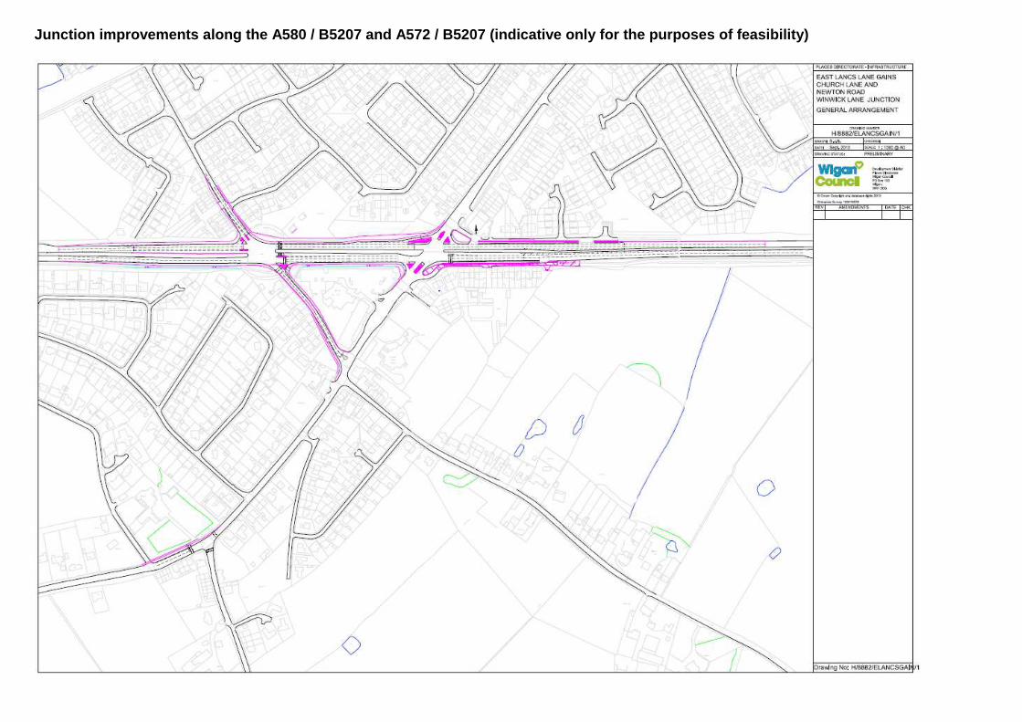
Junction improvements along the A580 / B5207 and A572 / B5207 (indicative only for the purposes of feasibility)

Widening the A752 / A579 junction at its south west (A572 St.Helens Road) and northern (A579 Atherleigh Way) approaches (indicative only for the purposes of feasibility)
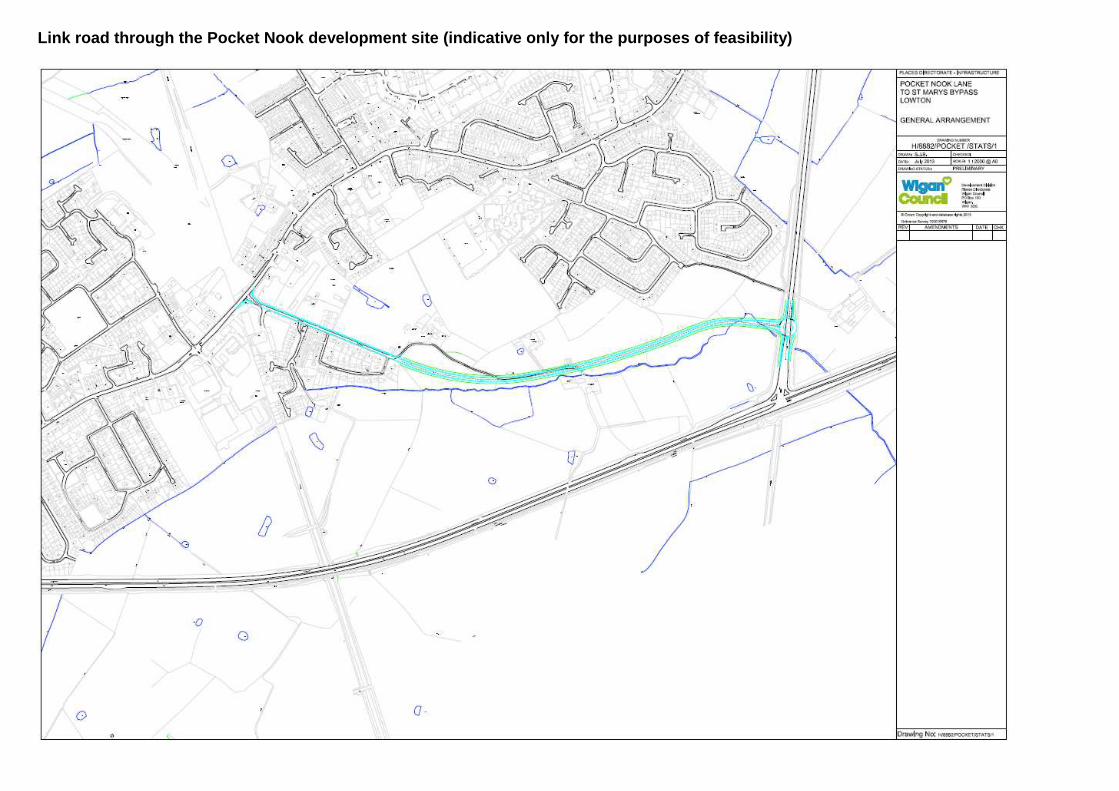
Link road through the Pocket Nook development site (indicative only for the purposes of feasibility)

Lane Head Bypass, options 1 and 2 (indicative only for the purposes of feasibility)