Embed Size (px)
Citation preview

GOES Direct ServicesGOES Direct Services
TopicsTopics
Direct Broadcast ServicesDirect Broadcast Services GOES Data Collection ServicesGOES Data Collection Services Search and RescueSearch and Rescue

GVAR / WEFAXGVAR / WEFAX
Primary customer interfacePrimary customer interface Worldwide imagery & weather charts (WEFAX)Worldwide imagery & weather charts (WEFAX) WEFAX - low-cost & easy accessWEFAX - low-cost & easy access GVAR - high resolution & continuous coverage GVAR - high resolution & continuous coverage Diverse customer baseDiverse customer base Web-based service and disseminationWeb-based service and dissemination

Global ReceiversGlobal Receivers
WMO Registrations (2001)WMO Registrations (2001)
• WEFAX = 4,900WEFAX = 4,900• HR / GVAR = 930HR / GVAR = 930
Registration not required. Estimated numbers ofRegistration not required. Estimated numbers ofreceivers 2X or 3X or more (particularly WEFAX)receivers 2X or 3X or more (particularly WEFAX)

Direct Readout Direct Readout ServicesServices
GOES AND POESGOES AND POESOn the WWW at http://noaasis.noaa.govOn the WWW at http://noaasis.noaa.gov

GOES USER GOES USER ASSISTANCEASSISTANCE
ASSIST EXTERNAL DIRECT READOUT USER ASSIST EXTERNAL DIRECT READOUT USER COMMUNITYCOMMUNITY
Web - based services for station operatorsWeb - based services for station operators Direct Services Division E/SP3Direct Services Division E/SP3 Satellite Services Division E/SP2 Satellite Services Division E/SP2 Office of Satellite Operations E/SOOffice of Satellite Operations E/SO Expect to continue in GOES-R eraExpect to continue in GOES-R era

GOES PRODUCTSGOES PRODUCTS
Near real-time access to NOAA GOES data:Near real-time access to NOAA GOES data:
Processed imagery via WWW and FTPProcessed imagery via WWW and FTP» NOAA/NESDIS, NASA, University, CommercialNOAA/NESDIS, NASA, University, Commercial
Imager and Sounder Products via WWWImager and Sounder Products via WWW» NOAA/NESDIS (OSDPD, ORA)NOAA/NESDIS (OSDPD, ORA)» University (Wisconsin/CIMSS, Colorado/CIRA)University (Wisconsin/CIMSS, Colorado/CIRA)

NOAA Data Collection Systems
Satellite
Ground Station Processing Center Usersplatforms

GOES DCS GOES DCS
Data Relay SystemData Relay System» Ground-based observing systems Ground-based observing systems » Transmit to GOES satellite at scheduled timesTransmit to GOES satellite at scheduled times» Downlinked to ground stations (NOAA, etc.)Downlinked to ground stations (NOAA, etc.)» Rebroadcast to commercial satellite Rebroadcast to commercial satellite
– Low-cost receiversLow-cost receivers» Available for download from NOAAAvailable for download from NOAA» Transmitted through GTS circuitsTransmitted through GTS circuits

GOES DCS USERSGOES DCS USERS
Government agenciesGovernment agencies Environmental observationsEnvironmental observations
» Flood forecastingFlood forecasting» Fire Detection and MonitoringFire Detection and Monitoring» Volcano MonitoringVolcano Monitoring» Earthquake/Tsunami MonitoringEarthquake/Tsunami Monitoring» Tide levelsTide levels» Climate monitoringClimate monitoring

GOES DCS UsersGOES DCS Users
USGSUSGS DOI — Bureau of Reclamation, Bureau of DOI — Bureau of Reclamation, Bureau of
Land ManagementLand Management NWS, NDBCNWS, NDBC NOSNOS USDA — Forest ServiceUSDA — Forest Service Army Corps of EngineersArmy Corps of Engineers

GOES DCS USERSGOES DCS USERS
Approximately 15,000 platformsApproximately 15,000 platforms 100,000+ observations per day100,000+ observations per day Approximately 100 mb of data per dayApproximately 100 mb of data per day 300 user agencies300 user agencies
» Federal governmentFederal government» State/local governmentState/local government» International government agenciesInternational government agencies

DCS Data ApplicationsDCS Data Applications
River Forecast 19% Analysis & Forecast 19%
Seismic 2%
Irrigation Control 3%
Navigation 4%
Fire Potential 6%
Improved DCS Ops 8%Water Quality Mont. 9%
Other 14%
Reservoir Management 16%
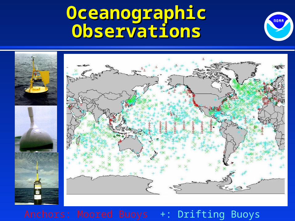
Oceanographic Oceanographic ObservationsObservations
Anchors: Moored Buoys +: Drifting Buoys X: Ocean Floats

GOES Weather Facsimile (WEFAX)
GOES M - Analog to Digital
- Timeshare between analog and digital
- Low Rate Information Transmission ( LRIT) CCSDS like protocol Multiple product transmission (64 kbps) Compatible with the Europeans and Japanese Ground system will require upgrades
GOES NGOES N - - Dedicated transponder- Full digital data stream- Improved product suite (128 kbps)- Ground system will require upgrades

WEFAX (cont)WEFAX (cont)
GOES-R Era
- Improved data rates (256 kbps)
- Modulation change from BPSK to Off-set QPSK (OQPSK)
- Downlink frequency change from 1693.4 MHz to 3 MHz higher (proposed)

GOES Variable GOES Variable (GVAR) (GVAR) GOES M GOES M - 6.7 micron resolution changes - 8km to 4km
- 12 micron channel replaced with 13.3 m channel
- New format / Blackbody calibration changes
GOES N - GOES N - minor changesminor changes
GOES RGOES R- - New format - GOES Re-Broadcast data stream- Full imager and sounder data stream - Packetized data format- Downlink frequency TBD

Emergency Managers Weather Information Network (EMWIN)
GOES-M Era- Continue to share GOES transponder with WEFAX service
- Test timeshare with LRIT service on non-operational GOES spacecraft
GOES-N Era
- Transmit on separate GOES transponder- Downlink frequency will change from 1690.725 MHz to 1692.7 MHz- Ground system will require upgrades- Data rate will be 9.6 kbps - Modulation changes from FSK to BPSK

EMWIN (Cont)EMWIN (Cont)
GOES-R Era
- Downlink frequency changes to 1692.7 MHz or 3 MHz higher (proposed)
- Date rate increase (56 kbps)
- Ground system will require upgrades

Search and RescueSearch and Rescue
- NESDIS manages and operates the U.S. portion of the International Cospas-Sarsat Program
- Cospas-Sarsat provides, free-of-charge, distress alert and location information to search and rescue authorities anywhere in the world for maritime, aviation and land users in distress.
- Over 250,000 406 MHz users currently
- Over 900,000 406 MHz users expected by launch of GOES-R
- 33 Countries formally part of Cospas-Sarsat

Search and RescueSearch and Rescue
Local User Terminal
Mission Control Center
Rescue Coordination
Center
POES Satellites
GOES Satellites
Emergency Beacons

Search and RescueSearch and Rescue
- Advantages of GOES:
- Near real-time detection for 406 MHz emergency beacons
- Near real-time location for 406 MHz beacons equipped with GPS
- Advantages of POES:
- Doppler location for existing 406 MHz beacons
- Global coverage
- Increased reliability (due to changing geometry)

Search and RescueSearch and Rescue
Future Enhancements
- Phase out of 121.5/243 MHz Satellite Processing - - increased number of 406 MHz beacon users through GOES
- Expanded use of GOES 406.0 – 406.1 MHz band through the introduction of new channels in the band
- Possible two-way capability on GOES-R that would allow a return link to the emergency beacon user (option being studied)