Embed Size (px)
Citation preview

Appendix 3 Glossary and Acronyms
Coalspur – Vista Project Appendix 4 – Acronyms and Glossary
April 2012 Appendix 4-1
ACRONYMS
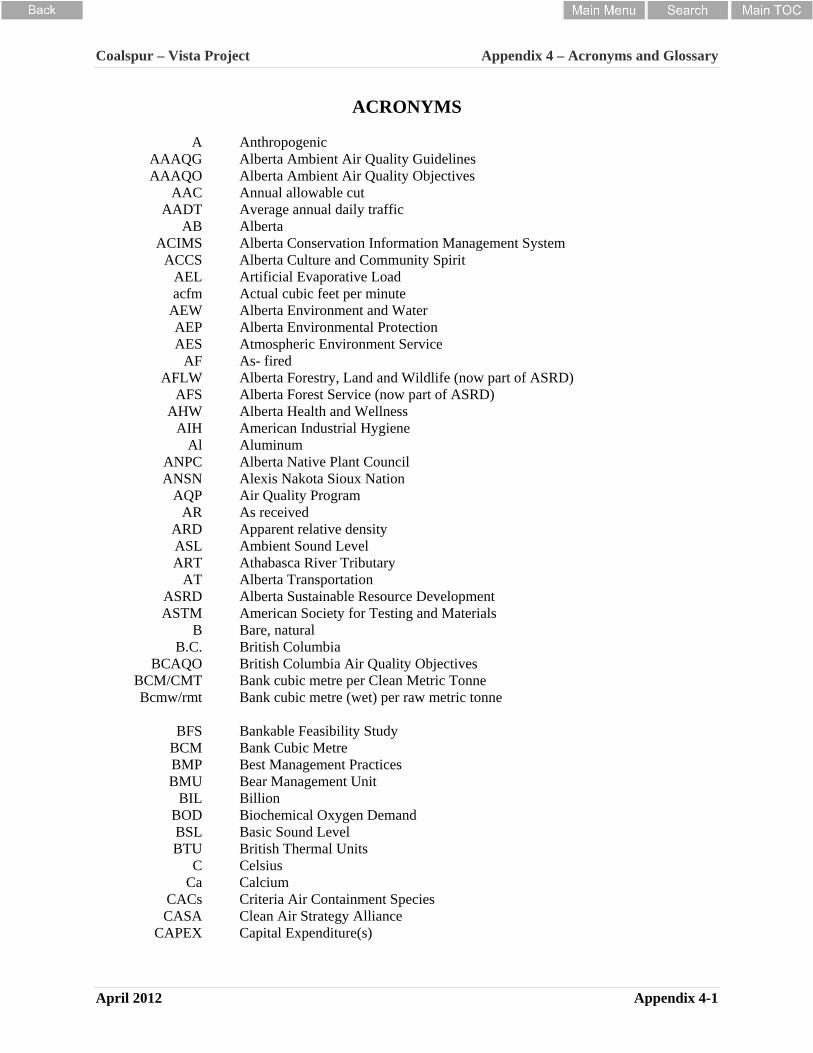
A Anthropogenic AAAQG Alberta Ambient Air Quality Guidelines AAAQO Alberta Ambient Air Quality Objectives
AAC Annual allowable cut AADT Average annual daily traffic
AB Alberta ACIMS Alberta Conservation Information Management System
ACCS Alberta Culture and Community Spirit AEL Artificial Evaporative Load acfm Actual cubic feet per minute
AEW Alberta Environment and Water AEP Alberta Environmental Protection AES Atmospheric Environment Service
AF As- fired AFLW Alberta Forestry, Land and Wildlife (now part of ASRD)
AFS Alberta Forest Service (now part of ASRD) AHW Alberta Health and Wellness
AIH American Industrial Hygiene Al Aluminum
ANPC Alberta Native Plant Council ANSN Alexis Nakota Sioux Nation
AQP Air Quality Program AR As received
ARD Apparent relative density ASL ART
Ambient Sound Level Athabasca River Tributary
AT Alberta Transportation ASRD Alberta Sustainable Resource Development ASTM American Society for Testing and Materials
B Bare, natural B.C. British Columbia
BCAQO British Columbia Air Quality Objectives BCM/CMT Bank cubic metre per Clean Metric Tonne Bcmw/rmt Bank cubic metre (wet) per raw metric tonne
BFS Bankable Feasibility Study
BCM Bank Cubic Metre BMP BMU
Best Management Practices Bear Management Unit
BIL Billion BOD Biochemical Oxygen Demand BSL Basic Sound Level BTU British Thermal Units
C Celsius Ca Calcium
CACs Criteria Air Containment Species CASA Clean Air Strategy Alliance
CAPEX Capital Expenditure(s)
Coalspur – Vista Project Appendix 4 – Acronyms and Glossary
April 2012 Appendix 4-2
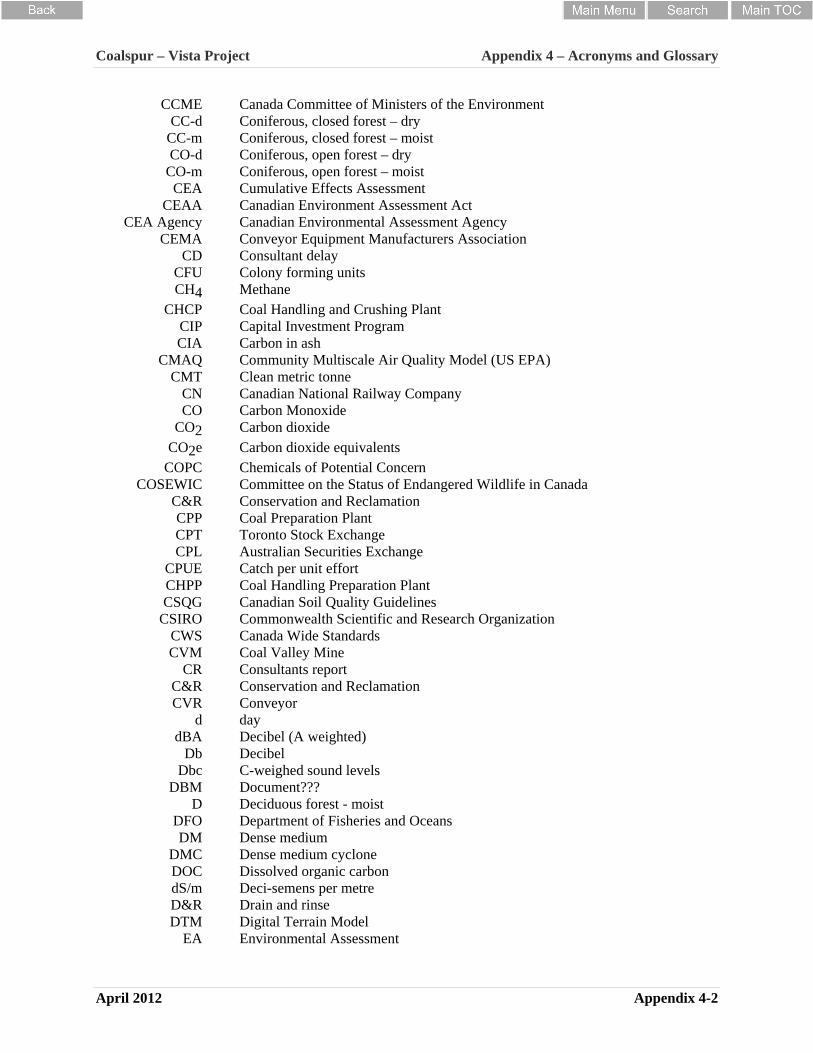
CCME Canada Committee of Ministers of the Environment CC-d Coniferous, closed forest – dry
CC-m Coniferous, closed forest – moist CO-d Coniferous, open forest – dry
CO-m CEA
Coniferous, open forest – moist Cumulative Effects Assessment
CEAA Canadian Environment Assessment Act CEA Agency Canadian Environmental Assessment Agency
CEMA Conveyor Equipment Manufacturers Association CD Consultant delay
CFU Colony forming units CH4 Methane
CHCP Coal Handling and Crushing Plant CIP Capital Investment Program CIA Carbon in ash
CMAQ Community Multiscale Air Quality Model (US EPA) CMT Clean metric tonne
CN Canadian National Railway Company CO Carbon Monoxide
CO2 Carbon dioxide CO2e Carbon dioxide equivalents
COPC Chemicals of Potential Concern COSEWIC Committee on the Status of Endangered Wildlife in Canada
C&R Conservation and Reclamation CPP Coal Preparation Plant CPT Toronto Stock Exchange CPL
CPUE Australian Securities Exchange Catch per unit effort
CHPP Coal Handling Preparation Plant CSQG Canadian Soil Quality Guidelines
CSIRO Commonwealth Scientific and Research Organization CWS Canada Wide Standards CVM Coal Valley Mine
CR Consultants report C&R Conservation and Reclamation CVR Conveyor
d day dBA Decibel (A weighted)
Db Decibel Dbc C-weighed sound levels
DBM Document??? D
DFO Deciduous forest - moist Department of Fisheries and Oceans
DM Dense medium DMC Dense medium cyclone DOC Dissolved organic carbon dS/m Deci-semens per metre D&R Drain and rinse DTM Digital Terrain Model
EA Environmental Assessment

Coalspur – Vista Project Appendix 4 – Acronyms and Glossary
April 2012 Appendix 4-3
E East ED Excused delay
EFN Ermineskin First Nation EH Effective head EP Ecart probable
EIA Environmental Impact Assessment ELC Ecological landscape classification EMT Emergency medical technician
EMT-P Emergency medical technician-Paramedic EPA United States Environmental Protection Agency
EPEA Environmental Protection and Enhancement Act EQM Equilibrium moisture
ERCB Energy Resources Conservation Board ERT Emergency Response Team E/L Earth leakage
FCSS Fe Iron
FEARO Federal Environmental Assessment and review office FoS Factor of safety
FP Filter press FEL Front end loader
FMA Forest Management Agreement FRI Foothills Research Institute
FRAG Forest Resources Advisory Group FSP Fines settling pond FSI Free swelling index
FTE Full time equivalent FTNN Treed fen
FW FWMIS
Forested wetland Fish and Wildlife Management Information Systems
FWP Fresh water pond FWR Fresh water reservoir
g/cc Grams per cubic centimetre g/m3 Grams per cubic metre
gar Gross as receive G-r Grassland-riparian G-u Grassland-upland GF Graminoid fen
GCM Global Climate Model GBRP
GBRSA Grizzly Bear Recovery Plan Grizzly Bear Regional Study Area
GDP Gross domestic product GHG Green house gas GSC Geological Survey of Canada GSI Geological strength index
g/t Grams per tonne H Hydrogen H Horizontal h hour
Hg Mercury ha Hectare

Coalspur – Vista Project Appendix 4 – Acronyms and Glossary
April 2012 Appendix 4-4
HADD Harmful alteration, disruption or destruction of fish or fish habitat HBS Hindered bed separator
HDPE High density polyethylene HGI Hardgrove Index
HHRA Human Health Risk Assessment HOA Hand off auto
HQ Hazard quotient HRIA Historical Resources Impact Assessment
HRMB Historic Resources Management Branch HSE Health Safety and Environment
hr Hour HRO Historical Resources Overview HRV Historical resource value
HVAC Heating, Ventilation, Air Conditioning IDF Intensity duration frequency
ILCR Incremental lifetime cancer risk IFN Instream flow needs ISO International Organization from Standardization
IPCC Intergovernmental Panel on Climate Change IRP Integrated Resource Plan
K(SiAl3O8) Potassium aluminum silicate KAl2(OH)2AlSi3(
O,OH)10 potassium aluminum silicate hydroxide
K Kelvin - equal to +273 C kg kilogram
kPa kph
Kilopascals Kilometer per hour
Keq kiloequivalent – equal to 1 1kmol of hydrogen ion (H+) km kilometre kw kilowatt
kj/kg calories per kilogram kj/hr Kilojoules per hour
kcal/kg Kilocalorie per kilogram kV kilovolts
km2 square kilometres L Litre
Leq equivalent sound pressure level L/s litres per second?
L/s/km2 Litres per second per square kilometre LCRC Land Conservation and Reclamation Council LCM Life Cycle Management lb/ft3 Pound per cubic feet
Li Lithium LF Lower Foothills
LFH Litter fermenting humified layer LOAEL Lowest-observable-adverse-effects level
LOC Licence of Occupation LOC Limiting oxygen concentration LOM Life of mine LOS Level of service LSA Local study area

Coalspur – Vista Project Appendix 4 – Acronyms and Glossary
April 2012 Appendix 4-5
LSD Legal subdivision M Marsh M Meridian m metre
m/year metres per year m ASL metres above sea level
MIT Minimum Ignition Temperature MEC Minimum Exposable Concentration
MAML Mobile Air Monitoring Laboratory
m2 square metres
m3/day Cubic metres per day
m3/hr Cubic metres per hour MVA Mega volt-amperes MPa Megapascal MR Modulus ratio mi Material index
Mg Magnesium m/s or m/sec metre per second
m3/s or ms/sec cubic metre per second Mbcm Million bank cubic metres mbgs Meters below ground surface
Mg milligram Mg/kg milligram per kilogram
mJ millijoule mg/L Milligrams per litre Mm millimetre or 1/1000th of a metre
Mm3 Million cubic metres MMTS Moose Mountain Technical Services
MLA Mineral liberation analyzer Mt Metric tonne
Mtpa Metric tonne per annum mtph Metric tonne per hour
MTPY Million clean tonnes per year Mj/kg Megajoule
MW Mega watt N North
Na Sodium n/a Not applicable
NAD North American Datum NCM Non centrifugal moisture
NE Northeast NNC Nakcowinewak Nation of Canada
NRCB Natural resource conservation board NW Northwest
N2O nitrous oxide NO2 nitrogen dioxide
NOAEL No observed adverse effect level NOX nitrous oxides
NRCAN Natural Resources Canada NPV Net present value
Coalspur – Vista Project Appendix 4 – Acronyms and Glossary
April 2012 Appendix 4-6
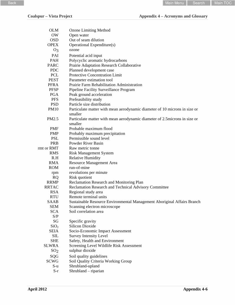
OLM Ozone Limiting Method OW Open water
OSD Out of seam dilution OPEX Operational Expenditure(s)
O3 ozone PAI Potential acid input
PAH Polycyclic aromatic hydrocarbons PARC Prairie Adaptation Research Collaborative
PDC Planned development case PCL Protective Concentration Limit
PEST Parameter estimation tool PFRA Prairie Farm Rehabilitation Administration PFSP Pipeline Facility Surveillance Program PGA Peak ground acceleration PFS Prefeasibility study PSD Particle size distribution
PM10 Particulate matter with mean aerodynamic diameter of 10 microns in size or smaller
PM2.5 Particulate matter with mean aerodynamic diameter of 2.5microns in size or smaller
PMF Probable maximum flood PMP Probably maximum precipitation PSL Permissible sound level PRB Powder River Basin
rmt or RMT Raw metric tonne RMS Risk Management System R.H Relative Humidity
RMA Resource Management Area ROM run-of-mine
rpm revolutions per minute RQ Risk quotient
RRMP Reclamation Research and Monitoring Plan RRTAC Reclamation Research and Technical Advisory Committee
RSA Regional study area RTU Remote terminal units
SAAB Sustainable Resource Environmental Management Aboriginal Affairs Branch SEM Scanning electron microscope SCA Soil correlation area
S/P SG Specific gravity
SiO2 Silicon Dioxide SEIA Socio-Economic Impact Assessment
SIL Survey Intensity Level SHE Safety, Health and Environment
SLWRA Screening Level Wildlife Risk Assessment SO2 sulphur dioxide SQG Soil quality guidelines
SCWG Soil Quality Criteria Working Group S-u Shrubland-upland S-r Shrubland – riparian
Coalspur – Vista Project Appendix 4 – Acronyms and Glossary
April 2012 Appendix 4-7
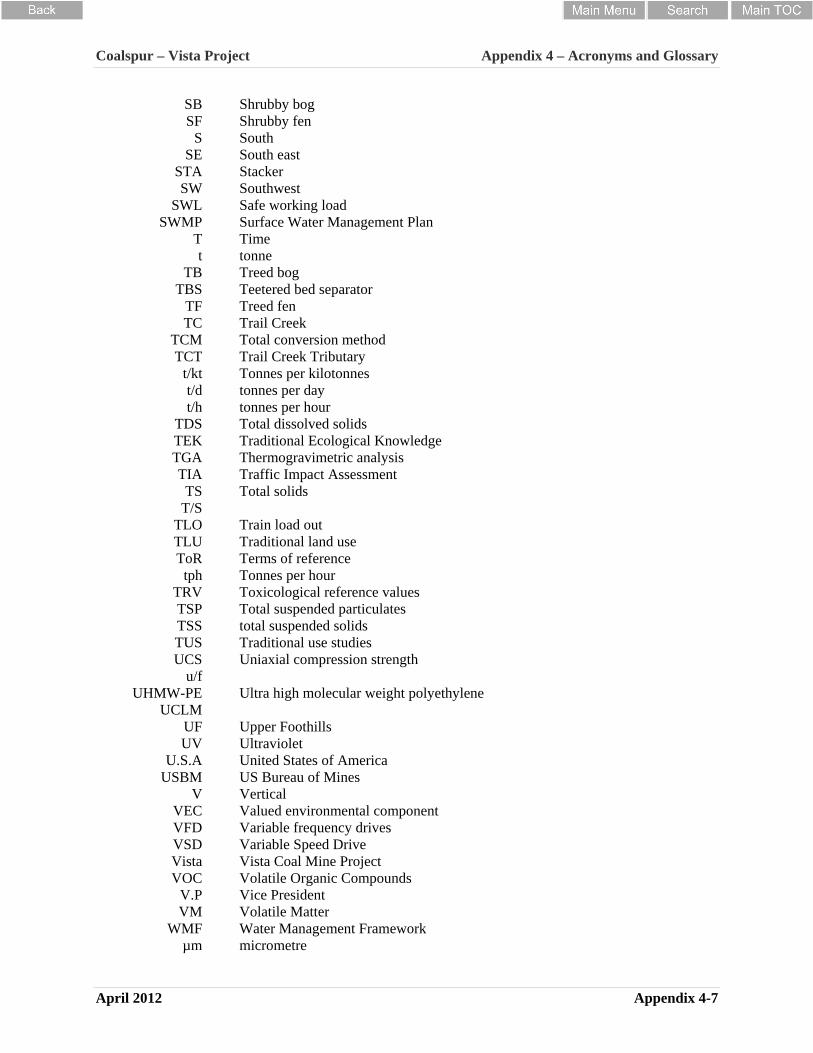
SB Shrubby bog SF Shrubby fen
S South SE South east
STA Stacker SW Southwest
SWL Safe working load SWMP Surface Water Management Plan
T Time t tonne
TB Treed bog TBS Teetered bed separator
TF TC
Treed fen Trail Creek
TCM TCT
Total conversion method Trail Creek Tributary
t/kt Tonnes per kilotonnes t/d tonnes per day t/h tonnes per hour
TDS Total dissolved solids TEK Traditional Ecological Knowledge TGA Thermogravimetric analysis TIA Traffic Impact Assessment TS Total solids
T/S TLO Train load out TLU Traditional land use ToR Terms of reference
tph Tonnes per hour TRV Toxicological reference values TSP Total suspended particulates TSS total suspended solids TUS Traditional use studies UCS Uniaxial compression strength
u/f UHMW-PE Ultra high molecular weight polyethylene
UCLM UF Upper Foothills UV Ultraviolet
U.S.A United States of America USBM US Bureau of Mines
V Vertical VEC Valued environmental component VFD Variable frequency drives VSD Variable Speed Drive Vista Vista Coal Mine Project VOC Volatile Organic Compounds
V.P Vice President VM
WMF Volatile Matter Water Management Framework
µm micrometre

Coalspur – Vista Project Appendix 4 – Acronyms and Glossary
April 2012 Appendix 4-8
µg/m3 Microgram per cubic metre < Less than > Greater than # Number
% percent

Coalspur – Vista Project Appendix 4 – Acronyms and Glossary
April 2012 Appendix 4-9
GLOSSARY Aboriginal traditional land uses traditional land use means established use(s) by the Aboriginal peoples (including First Nations, Métis and Inuit) through generations of custom, belief, knowledge, experience and handed down to posterity orally and by practice. The uses signify means of livelihood for survival, access and transportation, cultural heritage, spiritual values and land ethic based on the principle of perpetual sustainability of natural resources (Métis Nation Association of Alberta, 1997)
acid soil soil of pH less than 6.5. Expert Committee on Soil Survey (1982)
ACIMS Alberta Conservation Information Management System. As part of the International Natural Heritage Network, ACIMS provides biodiversity information for the purpose of natural resource management, development planning, and conservation. Specifically, ACIMS tracks and watches population size and condition, global and sub-national status, and geographic range of several species of flora and fauna within the province.
acute toxicity “toxicity manifested within a relatively short time interval" (i.e. as short as a few minutes to as long as several days). Such toxicity is frequently caused by a single dose of the toxicant. Hodgson et al (1988)
adverse effect impairment of or damage to the environment, human health or safety or property. Province of Alberta Environmental Protection and Enhancement Act (AEPEA) (1992)
adverse effects to human health those effects, in this case primarily of a respiratory nature, that are medically significant physiologic or pathological changes generally evidenced by one or more of the following: (1) interference with the normal activity of the affected person or persons, (2) episodic respiratory illness, (3) incapacitating illness, (4) permanent respiratory injury, and/or (5) progressive respiratory dysfunction. Medical significance in this case can apply to a sensitive sub-group (e.g., the young, asthmatic or elderly). American Thoracic Society (1985).
affect to produce an effect upon. Webster's New Collegiate Dictionary (1973)
air contaminant any solid, liquid or gas or combination of any of them in the atmosphere resulting directly or indirectly from the activities of man.
airshed a term, denoting a geographical area, the whole of which, because of topography, meteorology, and climate, shares the same air mass. The term may also refer to an administrative boundary such as the West Central Airshed.
alkaline soil a soil that has a pH greater than 7.4. Expert Committee on Soil Survey (1982)
alluvial (also fluvial) material such as earth, sand, gravel, or other rock or mineral materials transported and laid down by flowing water. ERCB (1981)
ambient air (Alberta Environmental Protection) the atmosphere surrounding the earth, but does not include the atmosphere in a structure or in any underground space [Alberta Regulation 124/93, part 1(c)]. As illustrated by Section 8(1) of the regulations, this definition refers to the discharge "to the ambient air" and the definition does not specifically refer to locations where the public has access or environmentally sensitive receptors.
ambient noise the all-encompassing noise associated with a given environment, and is usually a composite of sounds from many sources, other than the source of interest, near and far. Health and Welfare Canada (1989)
ambient sound level the sound level that is present in the environment produced by acoustical sources other than the source of interest. Health and Welfare Canada (1989)
area source an emission source which emits over a specified area rather than from a point (e.g. stack). Examples of area sources are wind erosion from mined but as yet unreclaimed areas.

Coalspur – Vista Project Appendix 4 – Acronyms and Glossary
April 2012 Appendix 4-10
aspect the direction toward which a slope faces. ERCB (1981)
attenuation reduction in force. Powter (1994)
avifauna the birds of a specific region or period.
B Horizon a subsoil horizon characterized by one of: (1) an enrichment in clay, iron, aluminum, or humus (Bt or Bf). (2) a prismatic or columnar structure that exhibits pronounced coatings or stainings associated with significant amounts of exchangeable sodium (Bn or Bnt). (3) an alteration by hydrolysis, reduction, or oxidation to give a change in colour or structure from the horizons above or below, or both (Bm). Powter (1994)
background amounts of substances present in the ambient air due to natural (i.e., not man-made) sources.
baseline a description of conditions existing before development against which subsequent changes can be detected through monitoring. Baselines normally must consist of statistically adequate descriptions of the variability inherent in the valued environmental component prior to the onset of the planned action. As such, the baseline study itself is not a predictive tool, although it does describe the condition from which a valued environmental component is predicted to change. Beanlands and Duinker (1983)
bedrock the solid rock that underlies soil and the regolith or that is exposed at the surface. Powter (1994)
bedrock spoil the bedrock material that has been mined and dumped. It may consist of hard fragments of varying size or may be soil-sized particles. Powter (1994)
bench large steps or level areas cut into slopes
bentonite a type of mineral deposit consisting principally of montmorillonite clay. (A major constituent of drilling muds.) Powter (1994)
bioaccumulation a widespread term that describes a process by which chemical compounds are taken up by terrestrial and aquatic organisms from the medium directly and through the consumption of contaminated food. Powter (1994)
biodiversity variability among living organisms from all sources including inter alia, terrestrial, marine and other aquatic ecosystems and the ecological complexes of which they are part; this includes diversity within species, between species and of ecosystems. Biodiversity Working Group (1995)
biophysical the biological and physical-chemical components of the environment. It includes flora, fauna, atmosphere, noise, water, landform and soils (terrain), heritage resources, resource-associated land-use factors including (but not limited to) forestry, agriculture, and recreation. Alberta Energy and Natural Resources (1980)
bog (1) a peat-covered or peat-filled wetland, generally with a high water table having a low bearing strength. The water of a bog is generally acid and low in nutrients. Bogs usually support a black spruce forest but may also be treeless. They are usually covered with sphagnum and feathermosses and ericaceous shrubs. (2) a peat-covered area or peat-filled wetland, generally with a high water table. The water table is at or near the surface. The surface is often raised or level with the surrounding wetlands, and is virtually unaffected by the nutrient-rich groundwaters from the surrounding mineral soils. Hence, the groundwater of the bog is generally acid and low in nutrients. The dominant peat materials are Sphagnum and forest peat underlain, at times, by fen peat. The associated soils are Fibrisols, Mesisols and Organic Cryosols. The bogs may be treed or treeless and they are usually covered with Sphagnum mosses, feathermosses, and ericaceous shrubs. Powter (1994)
broadcast seeding scattering seed on the surface of the soil. Contrast with drill seeding which places the seed in rows in the soil. Powter (1994)
brunisolic these soils, which occur under a wide variety of climatic and vegetative conditions, all have Bm or Btj horizons. The great groups Melanic Brunisol, Eutric Brunisol, Sombric Brunisol, and Dystric Brunisol belong to this order. A soil order of sufficient

Coalspur – Vista Project Appendix 4 – Acronyms and Glossary
April 2012 Appendix 4-11
development to exclude it from the Regosolic order, but without sufficient development to include it in any other order. These soils develop under various climates and vegetation, and are frequently characterized by a reddish colour. Powter (1994)
bryophyte a general term for mosses and liverworts.
bulk density (soil) the mass of dry soil per unit of bulk volume. The mass is determined after drying to a constant weight at 105oC. The bulk volume is that of the sample as taken in the field and includes the volume of the solids and of the pore space. Measures of bulk density (Db) are expressed in SI units (kg/m3) and/or units derived from them. Mg/m3 is the preferred unit. Derived units, such as Mg/m3, t/m3 or g/cm3 are numerically equal. Db values generally range from 0.90 to 1.80 Mg/m3 (900 to 1800 kg/m3). In commercial and engineering applications, Db is often expressed in lb/ft3 and it has been called apparent density. Powter (1994)
C Horizon a mineral horizon comparatively unaffected by the pedogenic processes operative in the A and B horizons except for the process of gleying (Cg) or the accumulation of calcium carbonate (Cca) or other salts (Csa). A naturally calcareous C horizon is designated Ck. Powter (1994)
calcareous soil soil containing sufficient calcium carbonate, often with magnesium carbonate, to effervesce visibly when treated with cold 0.1 N hydrochloric acid. Powter (1994)
calcium carbonate equivalent the total inorganic carbon content of soil material expressed in terms of percent calcium carbonate (CaCO3). Powter (1994)
capability (land) an evaluation of land performance that focuses on the degree and nature of limitation imposed by the physical characteristics of a land unit on a certain use, assuming a management system. The suitability of land for use without permanent damage. It is an expression of the effect of physical land conditions, including climate, on the total suitability for use, without damage, for crops that require regular tillage, for grazing, for woodland and for wildlife. Land capability involves consideration of the risks of land damage from erosion and other causes and the difficulties in land evaluation owing to physical land
characteristics, including climate. Powter (1994)
cation an ion carrying a positive charge of electricity. The most common soil cations are calcium, magnesium, sodium, potassium, and hydrogen. Powter (1994)
check dam a) structure made from soil materials and used to stabilize and control undercutting of drainage ditches. b) small dam constructed in a gully or other small watercourse to decrease the streamflow velocity, minimize channel scour, and promote deposition of sediment. CN Engineering (1996)
chernozemic an order of soils that have developed under xerophytic or mesophytic grasses and forbs, or under grassland-forest transition vegetation, in cool to cold, subarid to subhumid climates. The soils have a dark-coloured surface (Ah, Ahe, or Ap) horizon and a B or C horizon, or both, of high base saturation. The order consists of the Brown, Dark Brown, Black, and Dark Grey great groups. Powter (1994)
chronic toxicity the development of adverse effects after an extended exposure (conventionally at least one-tenth of the expected life span of an organism), to relatively small quantities of a toxicant. Hodgson et al (1988)
clay (1) as a rock term: a natural, earthy, fine grained material that develops plasticity with a small amount of water. (2) as a soil term: a textural class. (3) as a soil separate: a material usually consisting largely of clay minerals but commonly also of amorphous free oxides and primary minerals. (4) As a particle-size term: a size fraction less than 0.002 mm equivalent diameter. Powter (1994)
coal a black or dark brown combustible mineral substance formed in nature by various degrees of metamorphism or coalification of vegetable matter. Miscellaneous coal terms include: a) bituminous coal is a relatively soft coal; a mineral coal which contains widely varying amounts of volatile hydrocarbons and tarry matter. b) metallurgical coal is coal with characteristics making it suitable for production of coke that can be used by the iron and steel industry. c) raw coal is unwashed coal. d) refuse is that portion of the seam as mined which is rejected by the preparation plant as unusable. e) run-of-mine (ROM) coal is coal as it leaves the mine, including impurities and before any size reduction. f) slurry is a
Coalspur – Vista Project Appendix 4 – Acronyms and Glossary
April 2012 Appendix 4-12
suspension of fine coal and other assorted materials in water; usually the largest particle does not exceed approximately 10 mesh in size. g) washed coal is coal which has been cleaned in a preparation plant to reduce impurities. Brumbaugh et al (1982)
coal seam a bed or stratum of coal; usually applied to large deposits of coal. The Coal Association of Canada (1985)
coarse texture (soil) the texture exhibited by sands, loamy sands, and sandy loams but not including very fine sandy loam. A soil containing large quantities of these textural classes. Powter (1994)
compaction increasing the density of a material by reducing the voids between the particles by mechanical effort. The closing of the pore spaces among the particles of soil and rock, generally caused by running heavy equipment over the area, as in the process of levelling the overburden material of strip mine banks. The moving of soil particles closer together by external forces. In the compaction process, individual soil particles are packed closer together and soil aggregates are crushed, thus greatly reducing porosity. The major causes of soil compaction are: (1) natural consolidation during soil forming processes (e.g. the weight of glaciers during the ice ages); (2) trampling by animals and humans; (3) natural shrinkage of soil upon drying; (4) use of heavy equipment. Powter (1994)
conifer a tree belonging to the order Coniferae with cones and evergreen leaves of needle shape or "scalelike". The tree is harvested to produce wood known commercially as "softwood". Powter (1994)
conservation a policy which seeks to sustain future useable supplies of a natural resource by present actions. The protection, improvement, and use of natural resources according to principles that will assure their highest economic or social benefits. The planning, management and implementation of an activity with the objective of protecting the essential physical, chemical and biological characteristics of the environment against degradation. Conservation (soil) (1) Protection of the soil against physical loss by erosion or against chemical deterioration; that is, excessive loss of fertility by either natural or artificial means. (2) A combination of all methods of management and land use that safeguard the soil
against depletion or deterioration by natural or man-induced factors. (3) The division of soil science dealing with soil conservation. Powter (1994)
consistence (1) the resistance of a material to deformation or rupture. (2) the degree of cohesion or adhesion of the soil mass. Terms used in soil survey for describing consistence at various soil-water contents are: Wet soil: non-sticky; slightly sticky; sticky; very sticky; non-plastic; slightly plastic; plastic and very plastic. Moist soil: loose; very friable; friable; firm; very firm; compact; very compact; and extremely compact. Dry soil: loose; soft; slightly hard; hard; very hard; and extremely hard. Cementation: weakly cemented; strongly cemented, and indurated. Powter (1994)
coversoil unconsolidated materials including salvaged surface soil, salvaged Regolith, or selected bedrock spoil used to top-dress spoils to build a better quality minesoil. Powter (1994)
criteria air contaminants a substance emitted to the air for which a national ambient air quality standard (NAAQS) has been promulgated by the U.S. EPA. Those criteria pollutants are particulate (PM10 and PM2.5), SO2, NO2, O3, CO and Pb.
critically imperilled plant species extremely rare, <5 occurrences in the province or only a few remaining individuals; or may be imperilled because of some factor of its biology which makes it especially to extiration. Argus and Pryer (1990)
cumulative environmental effect the effect on the environment which results from effects of a project when combined with those of other past, existing and imminent projects and activities. These may occur over a certain period of time and distance. Canadian Environmental Assessment Act (CEAA) (1994)
decibel (dBA) a single number sound pressure level measurement in decibels frequency weighted to provide a reasonable correlation to loudness as perceived by a human being. For example, a level of 40 dB could be represented by quiet conditions in a public library; whereas a level of 70 dB is analogous to the level of a typical TV set.
Coalspur – Vista Project Appendix 4 – Acronyms and Glossary
April 2012 Appendix 4-13
degradation (soil) the changing of a soil to a more highly leached and weathered state, usually accompanied by morphological changes such as the development of an eluviated, light coloured A horizon or a decline in soil quality. Processes include wind and water erosion, salinity, organic matter depletion, acidification and compaction. Powter (1994)
dewatering the removal of water from a volume of rock or soil to effect a drawdown of the water table.
dip the angle at which a vein, structure or rock bed in inclined from the horizontal, measured at right angles to the strike. Carrington (1971)
discharge the volumetric rate of flow of water in a stream.
discharge (of groundwater) a point or area in which groundwater leaves the subsurface environment and enters the surface environment.
dispersal the spreading of reproductive plant parts from one place or area to another. Powter (1994)
disturbed land land on which excavation has occurred or upon which overburden has been deposited, or both. Powter (1994)
diversion a channel constructed across a slope to intercept surface run-off, changing the course of all or part of a stream or the runoff, thereby reducing sediment problems. ERCB (1981)
drainage (soil) soil drainage refers to the frequency and duration of periods when the soil is not saturated. Terms used are - excessively, well, moderately, imperfectly, and poorly drained soil. Powter (1994)
drawdown the lowering of water levels caused by pumping of groundwater from wells, pits etc.
diurnal raptor bird of prey that hunt for food primarily on the wing, using their keen senses, especially vision.
ecodistrict a subdivision of an ecoregion based upon distinct physiographic and/or geologic patterns. Lacate (1969)
ecological receptor a non-human organism identified as potentially experiencing adverse effects from exposure to contaminated soil either directly through contact or indirectly through food chain transfer. Powter (1994)
ecoregion an area characterized by a distinctive regional climate as expressed by vegetation. Lacate (1969)
ecosite a subdivision of an ecosection and an area with a unique recurring combination of vegetation, soil, landform, and other environmental components. Strong and Anderson (1980)
ecosystem a community of interdependent animals and plants, including humans, together with the total environment which they inhabit, interact with, and which interacts. Tilleman (1994)
ecotype a local ecological race adapted through natural selection to a particular habitat. Powter (1994)
effect (a) Direct effects, which are caused by the action and occur at the same time and place. (b) Indirect effects, which are caused by the action and are later in time or farther removed in distance, but are still reasonably foreseeable. Indirect effects may include growth inducing effects and other effects related to induced changes in the pattern of land use, population density or growth rate and related effects on air and water and other natural systems, including ecosystems.
Effects and impacts are synonymous. Effects include ecological (such as the effects on natural resources and on the components, structures, and functioning of affected ecosystems), aesthetic, historic, cultural, economic, social, or health, whether direct, indirect, or cumulative. Effects may also include those resulting from actions which may have both beneficial and detrimental effects."
eluviation the removal of soil material in suspension or in solution from a layer or layers of the soil by the downward or lateral movement of water. Powter
Coalspur – Vista Project Appendix 4 – Acronyms and Glossary
April 2012 Appendix 4-14
(1994)
emission factor an average value which relates the quantity of a substance released to the atmosphere with the activity associated with the release of that substance. It is usually expressed as the weight of that substance divided by a unit weight, volume, distance or duration of the activity that emits the substance (e.g., kilograms of particulate emitted per tonne of rock moved). Using such factors permits the estimation of emissions from various sources of air pollution. In most cases, these factors are simply averages of all available data of acceptable quality, generally without consideration for the influence of various process parameters such as temperature, reactant concentrations, etc.
environment the components of the earth and includes: (i) air, land and water; (ii) all layers of the atmosphere; (iii) all organic and inorganic matter and living organisms; and (iv) the interacting natural systems that include these components.
environment (CEAA) the components of the Earth, and includes
(a) land, water and air, including all layers of the atmosphere,
(b) all organic and inorganic matter and living organisms, and
(c) the interacting natural systems that include components referred to in paragraphs (a) and (b). Source: Canadian Environmental Assessment Act (CEAA).
environmental assessment in respect of a project, an assessment of the environmental effects of the project that is conducted in accordance with AEPEA, CEAA and the associated regulations.
environmental effect means, in respect of a project, (a) any change that the project may cause in the environment, including any effect of any such change on health and socio-economic conditions, on physical and cultural heritage, on the current use of lands and resources for traditional purposes by aboriginal persons, or on any structure, site or thing that is of historical, archaeological, palaeontological or architectural significance, and (b) any change to the project that may be caused by the environment, whether any such change occurs within or outside Canada. Canadian
Environmental Assessment Act (CEAA) (1994)
environmental impact the net change, positive or negative, in human health and well-being that results from an environmental effect, including the well-being of the ecosystem on which human survival depends. Tilleman (1994)
environmental impact assessment a process or set of activities designed to contribute pertinent environmental information to project or program decision-making. In doing so, it attempts to predict or measure the environmental effects of specific human activities or do both, and to investigate and propose means of ameliorating those effects. The sequence of environmental impact assessment events: a) baseline study phase; b) interpretive, predictive and evaluative phase; and c) post-construction assessment phase. Beanlands and Duinker (1983)
environmental management system organizational structure, responsibilities, practices, procedures, processes and resources for implementing and maintaining environmental management. Committee Draft of the International Organization for Standardization (ISO) Environmental Management Systems - General Guidelines on Principles, Systems and Supporting Techniques (ISO 14000) Standard (February 1995)
equivalent capability (land) the ability of the land to support various land uses after reclamation is similar to the ability that existed prior to any activity being conducted on the land, but the ability to support individual land uses will not necessarily be equal after reclamation. Powter (1994)
equivalent sound pressure level (Leq) the level of a steady sound having the same time integral of the squared sound pressure, in the measurement interval, as the observed sound. Health and Welfare Canada (1989)
erodibility a measure of the susceptibility of a soil to particle detachment and transport by rainfall and runoff. Powter (1994)
erosion the wearing away of the land surface by running water, wind, ice, other geological agents, activities of man or animals, and including such processes as gravitational creep. Erosion may be either normal or accelerated; the latter being brought about by changes in the natural cover or ground conditions, including

Coalspur – Vista Project Appendix 4 – Acronyms and Glossary
April 2012 Appendix 4-15
those due to human activity. Powter (1994)
eutrophic term referring to peatlands that are relatively nutrient-rich; also refers to soils and waters with high nutrient content and high biological activity. Powter (1994)
evapotranspiration potential evapotranspiration is the maximum transpiration that can occur in a given weather situation with a low-growing crop that is not short of water and does not completely shade the ground. The process of evaporation of water from a soil surface together with transpiration by plants. Powter (1994)
exposure characterization identification of the conditions of contact between a substance and an individual or population. It may involve identification of concentration, routes of uptake, target sources, environmental pathways, and the population at risk. Powter (1994)
exposure contact between a substance and an individual or population. It may occur via different pathways including oral, dermal and inhalation. Powter (1994)
fault a break in the earth's crust caused by forces which have moved the rock on one side with respect to the other; faults may extend for miles, or be only a few inches in length; similarly the movement or displacement along the fault may vary widely; ore deposits are commonly associated with faults, as the movement frequently provides a channel for the passage of ore-bearing solutions. Carrington (1971)
fen a peat-covered or peat-filled wetland with a high water table that is usually at or above the surface. The waters are mainly nutrient-rich, minerotrophic waters from mineral soils. The dominant peat materials are shallow to deep, well to moderately decomposed fen peat. The associated soils are Mesisols, Humisols, and Organic Cryosols. The vegetation consists dominantly of sedges, grasses, reeds, and brown mosses, with some shrub cover and, at times, a scanty tree layer. Powter (1994)
final cut (end cut) last cut or line of excavation made on a specific property or area. Powter (1994)
fine texture (soil) consisting of or containing large quantities of the fine
fractions, particularly silt and clay. Powter (1994)
fines the small particles of coal resulting from breakage of larger pieces. Brumbaugh et al (1982)
Fines settling pond this pond serves to settle out unwanted particulates to provide a supernatant quality that meets plant processing needs and/or controlled discharge to the surrounding water shed through seepage or controlled discharge.
firm a term describing the consistence of a moist soil that offers distinctly noticeable resistance to crushing, but can be crushed with moderate pressure between the thumb and forefinger. Powter (1994)
First Nations a band or First Nation is defined in the Indian Act as a body of Indians for whose common use and benefit lands have been set aside of monies held by the Government of Canada or declared by the Governor in Council to be a band. Most bands prefer to be referred to as First Nations. Alberta Intergovernmental and Aboriginal Affairs (1997)
flocculation a grouping of dispersed particles into relatively stable clumps. It is primarily a conditioning process during which some type of compound is added to a mixture of coal and other particles with water, thereby causing the solids to settle. Brumbaugh et al (1982)
flora a general term for plants, a list of the plant species present in an area Cauboue et al. (1996).
fluvial (deposits) material that has been transported and deposited by streams and rivers. Powter (1994)
fold any bending or wrinkling of a rock strata. Carrington (1971)
footwall the wall or rock on the underside of a vein or ore structure. Carrington (1971)
forage unharvested plant material which can be used as feed by domestic animals. Forage may be grazed or cut for hay. Powter (1994)
Coalspur – Vista Project Appendix 4 – Acronyms and Glossary
April 2012 Appendix 4-16
forb a herbaceous plant which is not a grass, sedge, or rush. Powter (1994)
forest land land bearing a stand of trees at any age or stature, including seedlings and of species attaining a minimum of 6 feet average height at maturity or land from which such a stand has been removed but on which no other use has been substituted. The term is commonly limited to land not in farms; forests on farms are commonly called woodland or farm forests. Powter (1994)
fracture refers to a break in the rock. The opening affords the opportunity for entry of mineral bearing solutions. A cross-fracture is a minor break extending at more or less right angles to the direction of the principal fractures. Carrington (1971)
fresh water pond The fresh water pond is needed as a source of processing water for a short period of time during startup when return water from the fines settling pond is not available. The source of water for the fresh water pond will be from surface run off, pit dewatering and ground water wells. Once return water from the fines settling ponds is plentiful and consistent, the reliance on the fresh water pond will be minimal. Firefighting, potable, gland seal, flocculant mixing, wash down water will be provided by ground water wells.
friable a term pertaining to the ease of crumbling of soils. Powter (1994)
full-time equivalent is a term applied to a full-day job which lasts for a full year, or to part-time jobs which have been converted to this standard. For example, two full-day jobs, each lasting for six months, are equal to 1 full-time equivalent job. One half-day lasting a full year is equal to one-half of a full-time equivalent job
geology the science concerned with the study of the rocks which compose the earth. Carrington (1971)
gleyed soil a soil affected by gleysation. Powter (1994)
gleysation a soil-forming process under conditions of poor drainage resulting in reduction of iron and other
elements and in grey colours and mottles. Powter (1994)
gleysolic an order of soils developed under wet conditions and permanent or periodic reduction. These soils have low chromas, or prominent mottling, or both, in some horizons. The great groups Gleysol, Humic Gleysol, and Luvic Gleysol are included in the order. Powter (1994)
graminoid a grass-like plant, includes both grass and sedge species.
green area that part of Alberta shown outlined and coloured green on the map annexed to; (1) a Ministerial Order dated April 15, 1989 and made pursuant to Section 10 of the Public Lands Act, as that order is amended from time to time, or (2) any order made in substitution for that order, as amended from time to time. Powter (1994)
greenhouse gases the gases listed in Annex A of the Kyoto Protocol to the United Nations Framework Convention on Climate Change: carbon dioxide (CO2), methane (CH4), nitrous oxide (N2O), hydrofluorocarbons (HFCs), perfluorocarbons (PFCs), and sulphur hexafluoride (SF6).
ground cover any living or dead vegetative material producing a protective mat on or just above the soil surface. Powter (1994)
groundwater that water which at any particular time is either passing through or standing in the soil and underlying strata and is free to move under the influence of gravity. Powter (1994)
growth medium any soil material capable of supporting vegetation growth, and can be in situ or placed, native or treated. B.C. Ministry of Energy, Mines and Petroleum Resources (1990)
guideline a) means a numerical concentration, value or narrative statement recommended to support and maintain a designated use or prevent deterioration of water/air quality. A guideline is generally derived from the lowest observable effects level obtained from biological tests of chronic toxicity. The lowest

Coalspur – Vista Project Appendix 4 – Acronyms and Glossary
April 2012 Appendix 4-17
observable effects level obtained from the criteria data is then multiplied by a safety factor to provide for long term protection of important sensitive fish, plant, and animal species or other uses. A guideline for any one contaminant may suggest a range of acceptable numerical values based on multiple uses. b) a recommended or acceptable course of action which is not a regulation. Alberta Ambient Surface Water Quality Interim Guidelines and Alberta Ambient Air Quality Guidelines (1993)
habitat the natural environment of an organism. Powter (1994)
haul road (haulroad) roads from a pit to a loading dock, tipple, ramp, or preparation plant used for transporting mined material by truck. Powter (1994)
herb any flowering plant except those developing persistent woody bases and stems above ground. Powter (1994)
highwall the unexcavated face of exposed overburden and mineral in a surface mine or the face or bank on the hill side of a contour strip mining excavation. Powter (1994)
horizon (soil) a layer of soil or soil material approximately parallel to the land surface and differing from adjacent genetically related layers in physical, chemical, and biological properties or characteristics, such as colour, structure, texture, consistency, kinds and number of organisms present, degree of acidity or alkalinity. Powter (1994)
humus (1) the fraction of the soil organic matter that remains after most of the added plant and animal residues has decomposed. It is usually dark coloured. (2) used in the broader sense to refer to forest humus forms (mor, moder, mull). (3) all the dead organic material on and in the soil that undergoes continuous breakdown, change, and synthesis. The more or less stable fraction from the decomposed soil organic material generally amorphous, colloidal, and dark coloured. Powter (1994)
hydraulic conductivity a measure of the ability of a rock, sediment or soil to transmit water.
hydric water removed so slowly that the water table is at or above the soil surface all year Luttmerding et al. (1990).
hydrophyte a plant that grows in water, or in wet or saturated soils; water-loving. Powter (1994)
hygric water removed slow enough to keep the soil wet for most of the growing season Cauboue et al. (1996).
hygrophytic plants requiring abundant water during all its developmental stages Cauboue et al. (1996).
illuviation the process of deposition of soil material removed from one horizon to another in the soil, usually from an upper to a lower horizon in the soil profile. Illuviated compounds include silicate clays, iron and aluminum hydrous oxides, and organic matter. Powter (1994)
impact is synonymous with effect. See definition of "Effect".
imperilled plant species very rare, 6-20 occurrences or with many individuals in fewer occurrences; or may be susceptible to extirpation because of some factor of its biology. Argus and Pryer (1990)
impermeability the condition of a rock, sediment, or soil that renders it incapable of transmitting fluids under pressure. Powter (1994)
indirect impacts represent the effect of the second and subsequent rounds of expenditures by the suppliers of goods and services. Suppliers to CVM generate demand for labour and goods and services produced by other industries, and earned business income. This pattern of expenditure flow continues in the economy. Goods and services purchased in the first round ultimately become labour income, business income, and indirect taxes to government, within the area under study or, if the goods and services are imported, these effects leak out of the economy as imports.
Coalspur – Vista Project Appendix 4 – Acronyms and Glossary
April 2012 Appendix 4-18
invasive plant species a plant that has moved into a habitat and reproduced so aggressively that it has displaced some of the original components of the vegetative community. Powter (1994)
lacustrine material deposited in lake water and later exposed. Powter (1994)
land capability the ability of the land to support a given land use, based on an evaluation of the physical, chemical and biological characteristics of the land, including topography, drainage, hydrology, soils and vegetation. Powter (1994)
land classification classification of specific bodies of land according to their characteristics or to their capabilities for use. A use capability classification may be defined as one based on both physical and economic considerations according to their capabilities for man's use, with sufficient (mapping) expression to indicate those differences significant to man. Land Treatment (drilling wastes). Powter (1994)
landscape all the natural features such as fields, hills, forests, water, etc., which distinguish one part of the earth's surface from another part. Usually that portion of land or territory which the eye can see in a single view, including all its natural characteristics. Powter (1994)
leachate used to emphasize the chemical species in an aqueous medium. Leachate may have several chemical species in varying concentrations in an aqueous medium. Leachate may also be generated by organic solvents. Powter (1994)
legume a member of the legume or pulse family, leguminosae. One of the most important and widely distributed plant families. Includes many valuable food and forage species, such as the peas, beans, peanuts, clovers, alfalfas, sweetclovers, lespedezas, vetches and kudzu. Practically all legumes are nitrogen-fixing plants. Powter (1994).
lichens a nonvascular plant that consists of an algae and a fungi that coexist.
lift removal of topsoil and subsoil prior to overburden removal or pipeline installation. Lifts can be made in a series of stages, e.g., one-lift or two-lift operations. Powter (1994)
lithic layer bedrock under the control section of a soil. Hard, consolidated bedrock. A feature of a soil subgroup which indicates a bedrock contact within 50 cm of the soil surface. Powter (1994)
litter the amount of previous year's plant growth left on the soil surface for nutrient recycling. Powter (1994)
luvisolic an order of soils that have eluvial (Ae) horizons, and illuvial (Bt) horizons in which silicate clay is the main accumulation product. The soils developed under forest of forest-grassland transition in a moderate to cool climate. The Grey Luvisol great group is the most common in western Canada. Powter (1994)
marsh a class in the Canadian wetland classification system; a marsh is a mineral or a peat-filled wetland which is periodically inundated by standing or slowly moving water. Surface water levels may fluctuate seasonally, with declining levels exposing drawdown zones of matted vegetation or mud flats. The waters are nutrient-rich. The substratum usually consists dominantly of mineral material, although some marshes are associated with peat deposits. The associated soils are dominantly Gleysols with some Humisols and Mesisols. Marshes characteristically show a zonal or mosaic surface pattern of vegetation consisting of unconsolidated grass and sedge sods, frequently interspersed with channels or pools of open water. Marshes may be bordered by peripheral bands of trees and shrubs, but the predominant vegetation consists of a variety of emergent non-woody plants such as rushes, reeds, reed-grasses, and sedges. Where open water areas occur, a variety of submerged and floating aquatic plants flourish. Powter (1994)
median (statistical) the middle value in a set of numbers – one-half of the set is higher and one-half is lower than the median.
mesic organic materials at a stage of decomposition between that of fibric and humic materials; peat soil material with >10% and <40% rubbed fibres; mesic
Coalspur – Vista Project Appendix 4 – Acronyms and Glossary
April 2012 Appendix 4-19
material usually is classified in the von Post scale of decomposition as class 5 or 6. Powter (1994)
mesotrophic containing a moderate amount of plant nutrients. Powter (1994)
Métis an Aboriginal person who received, or was entitled to receive, land grants and/or Scrip under the provisions of the Manitoba Act, 1871 or the Dominion Lands Acts, as enacted from time to time; or a person of Aboriginal descent who is accepted by the Métis Nation Accord, July 1992). (Métis Nation of Alberta Association, 1997)
micro-climate a local climatic condition near the ground resulting from modification of the general climate by local differences in elevation, exposure, or cover. Powter (1994)
mine any opening in, excavation in, or working of the surface or subsurface for the purpose of working, recovering, opening up, or providing coal, a coal bearing substance, oil sands or an oil sands bearing substance and includes any associated infrastructure. Powter (1994)
mine dump any area covered with overburden and other waste materials from ore and coal mines, quarries and smelters, and usually having little or no vegetative cover prior to reclamation. Powter (1994)
mine site an area in which facilities for extracting coal exist or are to be developed and includes: (i) a mine; (ii) a coal processing plant; (iii) a coal storage facility; (iv) a discard disposal site; (v) all connected private access roads and other related infrastructure which exist or are to be developed in connection with the mine; or (vi) a location designated by the Board as a mine site.
mineral soil a soil consisting predominantly of, and having its properties determined predominantly by, mineral matter. It contains less than 17% organic carbon except for an organic surface layer that may be up to 40 cm (16 inches) thick if formed of mixed peat (bulk density 0.1 or more) or 60 cm (24 inches) if of fibric moss peat (bulk density less than 0.1). Powter (1994)
minesoil soil produced by mining and reclamation activities that is capable of supporting plant growth. Powter (1994).
minesoil landscape the post mining equivalent of a natural soil landscape, which is an area of land with a distinctive pattern of surface form, surficial geological materials, lakes and wetlands, and soils. Knapik et al (1995)
minesoil profile the sequence of soil layers or horizons to a depth of approximately one metre. It is constructed by placing lifts of soil materials in sequence. Minesoil profiles are not reconstructions of the pre-mining soil profile; they are distinctly different and have their own characteristics. Knapik et al (1995)
mining operations those activities necessary for the development, operations and abandonment of a mine and includes:
(i.) the removal, storage and replacement of soils for reclamation;
(ii.) the removal and disposal of discard materials;
(iii.) the recovery, storage and transportation of coal between the mine and coal processing plant, power plant or shipping point; and
(iv.) site and infrastructure preparation required for development of a mine site. Coal Conservation Act (Draft 12).
mitigation in respect of a project, the elimination, reduction or control of the adverse environmental effects of the project, and includes restitution for any damage to the environment caused by such effects through replacement, restoration, compensation or any other means. Canadian Environmental Assessment Act (CEAA) (1994)
moderately well drained soil moisture is in excess of field capacity for a small but significant period of the year (National Soil Survey Committee 1974).
moisture regime refers to the available moisture supply for plant growth estimated in relative or absolute terms (Cauboue et al. 1996).
monitoring repetitive measurement of specific environmental

Coalspur – Vista Project Appendix 4 – Acronyms and Glossary
April 2012 Appendix 4-20
phenomena to document change primarily for the purpose of: a) testing impact hypotheses and predictions b) testing mitigative measures. Beanlands and Duinker (1983)
mottles spots or blotches of different colour or shades of colour found in imperfectly drained soils. Powter (1994)
mottling formation or presence of soil mottles. Powter (1994)
mycorrhiza the association of fungi with the roots of seed plants. Powter (1994)
native species a species that is a part of an area's original fauna or flora. Powter (1994)
natural area a parcel of sensitive or scenic public land protected from disturbance to ensure the availability of the land in a natural state for use by the public for recreation, education or any other purpose. Province of Alberta, Wildlife Areas, Ecological Reserves and Natural Areas Act (July 14 1995)
nocturnal Of, relating to, or occurring in the night; most active at night.
non-vascular plant a plant without a vascular system (e.g., mosses and lichens)
nutrient regime the relative level of nutrients available for plant growth (Cauboue et al. 1996).
objective 1a numerical concentration or narrative statement which has been established to support and protect the designated uses (e.g. water, air) at a specific area. Site specific conditions determine how an objective would be developed. An objective for a specific area will depend on existing and future uses and the most sensitive organisms that are present. 2A numerical limit or narrative statement that has been established to protect and maintain a specified use of soil, water or land at a particular site by taking account site-specific conditions. 1Alberta Ambient Surface Water Quality Interim Guidelines and Alberta Air Quality Guidelines (1993); 2Powter (1994)
oligotrophic (1) designation for peatlands that are poor to extremely poor in nutrients and with low biological activity; (2) containing a small amount of plant nutrients; refers to water slow in nutrient loading with low primary production of organic material by algae and/or macrophytes. Growth in an oligotrophic water is often limited by low levels of phosphorus and nitrogen. Powter (1994)
organic matter the organic fraction of the soil; includes plant and animal residues at various stages of decomposition, cells and tissues of soil organisms, and substances synthesized by the soil population. It is usually determined on soils that have been sieved through a 2.0 mm sieve. Powter (1994)
organic soils an order of soils that have developed dominantly from organic deposits. The majority of Organic soils are saturated for most of the year, unless artificially drained, but some of them are not usually saturated for more than a few days. Includes the Fibrisol, Mesisol, Humisol, and Folisol great groups. They contain 17% or more organic carbon, and: (1) if the surface layer consists of fibric organic material and the bulk density is less than 0.1 Mg m3 (with or without a mesic or humic Op less than 15 cm thick), the layer must extend to a depth of at least 60 cm; or (2) if the surface layer consists of organic material with a bulk density of 0.1 Mg m3 or more, the organic material must extend to a depth of at least 40 cm; or (3) if a lithic contact occurs at a depth shallower than stated in (1) or (2) above, the organic material must extend to a depth of at least 10 cm. Powter (1994)
organic carbon (soil) the percent by weight of carbon in organic forms in soil materials, determined by the difference between total carbon (determined by dry combustion) and in organic carbon (determined by acid dissolution). Powter (1994)
outcrop an exposure of rock or a mineral deposit that can be seen on surface, i.e., it is not covered by overburden or water. Carrington (1971)
overburden materials of any nature, consolidated or unconsolidated, that overlie a deposit of useful materials. Overburden includes all geologic material below the soil profile and, above, between, and below the coal and is handled as either Regolith or Spoil. Powter (1994)
Coalspur – Vista Project Appendix 4 – Acronyms and Glossary
April 2012 Appendix 4-21
parent material the unconsolidated and more or less chemically weathered mineral organic matter from which the solum of a soil is developed by pedogenic processes. Powter (1994)
particle density mass per unit volume of the soil solid particles. Also referred to as bulk specific gravity. Powter (1994)
particle size the effective diameter of a particle measured by sedimentation, sieving, or micrometric methods. Sand: a soil particle between 0.05 and 2.00 mm in diameter. Silt: a soil separate consisting of particles between 0.05 and 0.002 mm in diameter. Clay: a size fraction less than 0.002 mm in diameter. Powter (1994)
particulate matter any material, other than uncombined water, which is suspended in or discharged into the atmosphere as a solid or liquid at standard conditions. Particulate (stack) emissions shall be determined by the appropriate monitoring procedure (e.g., 40 CFR 60, Method 5)
peat material constituting peatlands, exclusive of the live plant cover, consisting largely of organic residues accumulated as a result of incomplete decomposition of dead plant constituents under conditions of excessive moisture (submergence in water and/or waterlogging). Powter (1994)
peatland a generic term including all types of peat-covered terrain. Powter (1994)
permeable (permeability) a measure of the ability of a rock, sediment or soil to transmit a fluid. Frequently used incorrectly as a synonym for hydraulic conductivity. Hackbarth (1999)
pH (soil) the negative logarithm of the hydrogen-ion activity of a soil. The degree of acidity (or alkalinity) of a soil as determined by means of glass, quinhydrone, or other suitable electrode or indicator at a specific moisture content of soil-water ratio, and expressed in terms of the pH scale. Powter (1994)
physiographic region topographically similar landscapes with similar relief, structural geology, and elevation at a mapping scale
of 1:1,000,000 to 1:3,000,000 (Cauboue et al. 1996).
piezometer an instrument for measuring pressure head in a conduit, tank, soil, etc. It usually consists of a small pipe or tube tapped into the side of the container, connected with a manometer pressure gage, mercury or water column, or other device for indicating pressure head. See observation well. Powter (1994)
pit an excavation in the surface made for the purpose of removing, opening up, or proving coal, and includes any associated infrastructure, but does not include a mine. Powter (1994)
Pit run off settling pond(s) used for collection of mine surface water, dewatering of pits prior to mining. This pond would provide water for processing along with stream augmentation.
plant 1a group of buildings, and especially to their contained equipment, in which a process or function is carried out; on a mine it will include warehouses, hoisting equipment, compressors, repair shops, offices, mill or concentrator. 2Preparation plant refers to a facility where coal is prepared for market or other usage. It consists of a rather elaborate collection of facilities where coal is separated from its impurities, washed, thermally or mechanically dried, sized, stored and loaded for shipment or conveyed to use point. 1Carrington (1971), 2Brumbaugh et al (1982)
plant community a combination of plants that are dependent on their environment and influence one another and modify their own environment. Mueller-Dombois and Ellenberg (1974)
plot a vegetation sampling unit used to delineate a fixed amount of area for the purposes of estimating plant cover (Cauboue et al. 1996).
point source an emission source which emits over such a small area that it can be considered a point (e.g. stack
poor drainage soil moisture is in excess of field capacity in all horizons for a large part of the year (National Soil Survey Committee 1974).

Coalspur – Vista Project Appendix 4 – Acronyms and Glossary
April 2012 Appendix 4-22
porosity the volume percentage of the total bulk not occupied by solid particles. The ratio of volume of voids in a soil mass to the total volume of the mass. Powter (1994)
profile (soil) a vertical section of the soil through all its horizons and extending into the parent material. Powter (1994)
propagule a part of a plant that implants a new individual. Powter (1994)
rapidly drained soil moisture content that seldom exceeds field capacity in any horizon except immediately after water addition (National Soil Survey Committee 1974).
receptor the person or organism subjected to a chemical exposure. CanTox (1988) For air quality evaluation, receptor means location where ambient air concentrations are calculated using a dispersion model.
reforestation the natural or artificial restocking of an area with forest trees. Powter (1994)
regolith the unconsolidated mantle of weathered rock and soil material overlying solid rock. Unconsolidated overburden that lies above bedrock. It includes glacial drift and colluvial and fluvial deposits that occur below the premine soil but does not include soft (paralithic) weathered-in-place bedrock. Powter (1994)
reject the material extracted from the feed coal during cleaning for retreatment or discard. The stone or dirt discarded from a coal preparation plant, washery or other process, is of no value. Powter (1994)
residual impact those predicted impacts that remain after mitigating measures have been applied and mine abandonment operations have been completed. Tilleman (1994)
restoration the process of restoring site condition as they were before the land disturbance. Powter (1994)
revegetation the establishment of vegetation which replaces original ground cover following land disturbance. Powter (1994)
rip rap broken rock, cobbles, or boulders placed on earth surfaces, such as the face of a dam, bank of a stream or lining drainage channels, for protection against the action of water. Powter (1994)
riparian terrain directly created by channelized flowing water or within its direct zone of influence (Dunster and Dunster 1996).
RMT/BCM raw metric tonne (of coal) per bank cubic metre (of overburden and/or interburden).
root zone (rootzone) the part of the soil that is penetrated or can be penetrated by plant roots. Powter (1994)
runoff the portion of the total precipitation on an area that flows away through stream channels. Surface runoff does not enter the soil. Groundwater runoff or seepage flow from groundwater enters the soil before reaching the stream. Powter (1994)
saline soil a nonalkali soil containing soluble salts in such quantities that they interfere with the growth of most crop plants. The conductivity of the saturation extract is greater than 4 dS/m, the exchangeable-sodium percentage is less than 15, and the pH is usually less than 8.5. State in soil caused by the presence of soluble salt (ions such as Na, Ca, K, Mg, Cl, SO4) yielding an electrical conductivity of 2 dS/m. Powter (1994)
sand a soil particle between 0.05 and 2.0 mm in diameter. Powter (1994)
sandstone a sedimentary rock composed of fine grains of quartz, etc. which have been cemented together. Carrington (1971)
sediment the solid material, both mineral and organic, that is in suspension, is being transported, or has been moved from its surface of origin by air, water, gravity, or ice
Coalspur – Vista Project Appendix 4 – Acronyms and Glossary
April 2012 Appendix 4-23
and has come to rest on the earth's surface either above or below sea level. Powter (1994)
seepage a spot or zone where water oozes from the earth, often forming the source of a small spring. It is the slow flow of water into or from a soil. Seepage usually involves the lateral flow of water. It can also mean the emergence of water from the soil over an extensive area in contrast to a spring where it emerges from a local spot.
seral recognizably different successional stages along a successional pathway (Cauboue et al. 1996).
settling pond a water reservoir constructed for the confinement and retention of silt, gravel, rock, or other debris from a sediment-producing area. Powter (1994)
short-term exposure an exposure to a contaminant in a medium lasting a short time and usually severe enough to rapidly induce an effect. Often referred to as an acute exposure. Absolute definitions for this term vary from study to study. Powter (1994)
shrub a woody perennial plant differing from a tree by its low stature and by generally producing several basal shoots instead of a single trunk. Powter (1994)
significance (significantly) refers to both context and intensity. In terms of context, the significance of an action must be analyzed in several contexts - society as a whole (human, national), the affected region, the affected interests, and the locality. In terms of intensity, the significance of an action refers to the severity of impact. Significance varies with the setting of the proposed action. e.g. in the case of a site-specific action, significance usually depends on the effects in the locale rather than in the world as a whole. Both short-term and long-term effects are relevant. Responsible officials must bear in mind that more than one agency may make decisions about partial aspects of a major action. Tilleman (1994).
silt a soil separate consisting of particles between 0.05 to 0.002 mm in equivalent diameter. Powter (1994)
slope the degree of deviation of a surface from horizontal, measured in a numerical ratio, percent, or degrees.
Expressed as a ratio or percentage, the first number is the vertical distance (rise) and the second is the horizontal distance (run), as 2:1 or 200 percent. Expressed in degrees, it is the angle of the slope from the horizontal plane with a 90o slope being vertical (maximum) and 45o being a 1:1 slope. Powter (1994)
socio-economic includes employment, population, housing requirements, service, community land and infrastructure, and social adjustment considerations. Alberta Energy and Natural Resources (1980)
sodic soil (1) a soil having a pH greater than 8.5 or an exchangeable sodium percentage greater than 15 or both. (2) a soil that contains enough alkali (sodium) to interfere with the growth of most crop plants.
sodicity a measure of the amount of sodium on the exchange complex (often expressed as sodium adsorption ratio -SAR). Powter (1994)
soil (1) the unconsolidated material on the immediate surface of the earth that serves as a natural medium for the growth of land plants. (2) the naturally occurring unconsolidated material on the surface of the earth that has been influenced by parent material, climate (including the effects of moisture and temperature), macro- and micro-organisms, and relief, all acting over a period of time to produce soil that may differ from the material from which it was derived in many physical, chemical, mineralogical, biological, and morphological properties. (3) for the purpose of the Canadian taxonomic system, the earth's surface (the material that is to be classified) is divided into soil and nonsoil. Soil is the naturally occurring, unconsolidated, mineral or organic material at the earth's surface that is capable of supporting plant growth. It extends from the surface to 15 cm (6 inches) below the depth at which properties produced by soil-forming processes can be detected. These properties differ from those found in any underlying unconsolidated material. The soil-forming processes are defined as an interaction between climate, living organisms, and relief acting on soil and soil parent material. Unconsolidated material includes material cemented or compacted by soil-forming processes. Soil may have water covering its surface to a depth of 60 cm (24 inches) or less in the driest part of the year. Nonsoil is the collection of soil material or soil-like material that does not meet the preceding definition of soil. It

Coalspur – Vista Project Appendix 4 – Acronyms and Glossary
April 2012 Appendix 4-24
includes soil displaced by un-natural processes and unconsolidated material unaffected by soil-forming processes, except for the material that occurs within 15 cm (6 inches) below soil as defined. Nonsoil also includes unconsolidated mineral or organic material thinner than 10 cm (4 inches) overlying bedrock; organic material thinner than 40 cm (16 inches) overlying a hydric layer; and soil covered by more than 60 cm (24 inches) of water in the driest part of the year. Powter (1994)
soil horizon a layer of soil or soil material approximately parallel to the land surface distinguishable from adjacent layers by colour, structure, consistence, chemical, biological, and mineralogical composition. Powter (1994)
soil landscape model a defined and named repetitive grouping of soil bodies occurring together in an individual and natural characteristic pattern over the soil landscape. The attributes of a soil landscape model vary within more or less narrow limits that are determined by the intensity of the survey. A soil landscape model comprises all the map delineations that have the same name. A soil landscape model is conceptual; a map delineation is real. Powter (1994)
soil structure the combination or arrangement of primary soil particles into secondary particles, units, or peds. These peds may be, but usually are not, arranged in the profile in such a manner as to give a distinctive characteristic pattern. The peds are characterized and classified on the basis of size, shape, and degree of distinctness into classes, types, and grades. Structural units include: Blocky: Cube-like blocks of soil up to 10 cm in size, sometimes angular with well-defined planar faces, sometimes with curved surfaces and corners (subangular blocky). Columnar: Vertically oriented pillars, often six-sided, up to 15 cm in diameter with rounded tops. Such structures are common in B horizons of clayey soils in semiarid regions. Granular: Rounded aggregates, generally not much larger than 2 cm in diameter, often found in a loose condition in the A horizon. Where particularly porous, such units are called crumbs. Platy: Horizontally layered, thin and flat aggregates resembling wafers. Such structures occur, for example, in recently deposited clay soils. Prismatic: Vertically oriented pillars, often six-sided, up to 15 cm in diameter, with flat tops to the pillars; common in the B horizon of clayey soils in semiarid regions. Powter (1994)
soil survey a general term for the systematic examination of soils in the field and in the laboratory, their description and classification, the mapping of kinds of soil, and the interpretation of soils for many uses, including their suitabilities or limitations for growing various crops, grasses and trees, or for various engineering uses and predicting their behaviour under different management systems. Powter (1994)
soil texture the relative proportions of sand, silt or clay contained in a soil sample. Powter (1994)
spawning period the period of fertilization and subsequent deposition of eggs. CN Engineering (1996)
spoil the overburden or non-coal material removed in gaining access to the coal in surface mining. It is the debris or waste material from a mine. Powter (1994)
spoil pile a pile of spoiled overburden on a minesite. Powter (1994)
strata or stratum a distinct layer within a plant community (Cauboue et al. 1996).
strip to remove the overburden or barren rock overlying the orebody. Carrington (1971)
strip mine a procedure of mining which entails the complete removal of all material from over the product to be mined in a series of rows or strips. Powter (1994)
study area that area in which the proposed development may have measurable or otherwise significant physical, environmental, or socio-economic impacts. Alberta Environmental Protection (Jan. 23, 1995)
subhydric water removed from soil slowly enough to keep the water table at or near the surface for most of the year (Luttmerding et al. 1990).
subhygric water removed from soil slowly enough to keep the soil wet for a significant part of the growing season (Luttmerding et al. 1990).
Coalspur – Vista Project Appendix 4 – Acronyms and Glossary
April 2012 Appendix 4-25
submesic water removed readily in relation to supply (Luttmerding et al. 1990).
subsoil the soil material found beneath the topsoil but above the bedrock. Technically, the B horizon; broadly, the part of the profile below plough depth. Powter (1994)
subxeric water removed rapidly in relation to supply, soil is moist for short periods following precipitation (Luttmerding et al. 1990).
succession the natural sequence or evolution of plant communities, each stage dependent on the preceding one, and on environmental and management factors. Powter (1994)
surface mine a mine in which the coal lies near the surface and can be extracted by removing the covering layer of soil (overburden). The Coal Association of Canada (1985)
surface mining surface excavation for the purpose of removal of minerals. Techniques for surface mining include several operations: open pit, dredging, hydraulic mining, strip mining, and auger mining. Powter (1994)
surface water water in the hydrological cycle that is held or moves on the surface of the ground in lakes, rivers, streams, etc. and is subject to pollution from direction contamination or surface run-off. Hodgson et al (1988)
surface water management the proposed methods of collection, treatment, and discharge of all waters within the affected drainage area(s). ERCB (1981)
syncline a downarched fold in bedded or stratified rocks. Carrington (1971)
tailings a) mineral refuse from a milling operation usually deposited from a water medium. b) refers to the coal refuse material generated from coal processing operations. It is generally deposited in a water medium. Powter (1994)
till an unstratified, non-sorted deposit of gravel, boulders, sand and finer materials which has been transported by a glacier. Powter (1994)
topography the shape of the ground surface, such as hills, mountains, or plains. Steep topography indicates steep slopes or hilly land; flat topography indicates flat land with minor undulations and gentle slopes. Powter (1994)
topsoil the salvaged surface soil layers, consisting of A and B horizons plus roots and forest duff layer. Powter (1994)
total dissolved solids the total concentration of dissolved material in a water sample.
trace element chemical element present in a minor amount in water or soil. Powter (1994)
traditional land use the continual use of an area over a long period of time by people for gathering, hunting and spiritual use. (Oil Sands Mining - End Land Use Committee, 1997)
transect a sampling system that involves the measurement or recording of data along a line (Cauboue et al. 1996).
trophic level position in the food chain determined by the number of energy transfer steps to that level. Powter (1994)
ungulate meaning roughly "being hoofed" or "hoofed animal are several groups of mammals, most of which use the tips of their toes, usually hoofed, to sustain their whole body weight while moving. Examples include deer, elk, and moose.
undulating a regular sequence of gentle slopes that produce a wavelike pattern of low local relief with slope gradients of 2 to 5% (Expert Committee on Soil Survey 1987).
valued environmental component the component or attribute identified as a result of the scoping exercise. Attributes may be determined on

Coalspur – Vista Project Appendix 4 – Acronyms and Glossary
April 2012 Appendix 4-26
the basis of perceived public concerns related to social, cultural, economic or aesthetic values. They may also reflect scientific concerns identified by the professional community. Attributes are identified throughout the environmental impact assessment process. Beanlands and Duinker (1983)
vascular plant plant with a vascular or conductive system such as grasses and trees.
vegetation the general cover of plants growing on the landscape (Cauboue et al. 1996).
very poorly drained free water remains at or within 30 cm of the ground surface most of the year (National Soil Survey Committee 1974).
watercourse any natural stream or source of water, whether usually containing water or not, and includes any lake, river, creek, spring, ravine, swamp, and gulch. B.C. Ministry of Energy, Mines and Petroleum Resources (1990)
water-holding capacity the ability of soil to hold water. The water-holding capacity of sandy soils is usually considered to be low while that of clayey soils is high. Powter (1994)
water table elevation at which the pressure in the water is zero with respect to the atmospheric pressure. The upper limit of the soil or underlying rock material that is wholly saturated with water. Powter (1994)
weathering the physical and chemical disintegration, alteration, and decomposition of rocks and minerals at or near the earth's surface by atmospheric agents. Powter (1994)
well drained soil moisture content that does not normally exceed field capacity in any horizon for a significant part of the year (National Soil Survey Committee 1974).
wetland land having the water table at, near, or above the land surface or which is saturated for long enough periods to promote wetland or aquatic processes as indicated by hydric soils, hydrophytic vegetation, and various kinds of biological activity that are adapted to the wet
environment. Wetlands include peatlands and areas that are influenced by excess water but which, for climatic, edaphic or biotic reasons, produce little or no peat. Shallow open water, generally less than 2 m deep, is also included in wetlands. Powter (1994)
xeric describes a dry site (Cauboue et al. 1996). Water in soil removed very rapidly in relation to supply (Luttmerding et al. 1990).