Embed Size (px)
Citation preview
INTERNATIONAL JOURNAL OF ENVIRONMENTAL SCIENCES Volume 5, No 4, 2015
© Copyright by the authors - Licensee IPA- Under Creative Commons license 3.0
Research article ISSN 0976 – 4402
Received on July 2014 Published on January 2015 697
Global warming, glacial lakes and cloud burst events in Garhwal –Kumaon
Himalaya: A hypothetical analysis Pranab Kr. Das
Assistant Professor, Department of Geography, Sree Chaitanya College, Habra,
P.O- Prafullanagar, Habra, North 24 Parganas, West Bengal, India
doi: 10.6088/ijes.2014050100065
ABSTRACT
Cloud Burst in Garwal-Kumaon Himalaya, in the Indian state of Uttarakhand, is a common
phenomenon. Cloud Burst is a massive downpour associating with flashflood, landslide, and
earth flow that causes enough devastation in mountain areas. However, in recent years the
frequency of this event has been increased tremendously. One of the important causes of
frequent cloud burst is faster evaporation rate from high altitude glacial lakes. The mean
temperature of the Earth has been increased 0.75° C during last century due to global
warming, resulting faster destruction of mountain or valley glacier. This phenomenon is
already witnessed in Himalaya where glacier and glacial lakes are changing alarmingly.
Glacier retreating rate in Himalaya is 10 to 60 m per year. A well number of small glacier
(<0.2 sq km) have already disappeared. This glacier melts water and lake comes direct
contact with clouds due to higher altitude, create favorable condition of cloud burst in high
altitude areas of Uttarakhand. This paper is a Geographical approach to study the Cloud Burst
events in Garwal-Kumaon Himalaya highlighting the role of glacier melt water and high
altitude lakes on this catastrophic event.
Keywords: Cloud burst, Garhwal-Kumaon Himalaya, Global warming, Glacier melting,
Glacial lakes.
1. Introduction
Cloud Burst is an excessive downpour with in short time over a smaller area. In plain areas
water logged condition or localized flood can be occurred after cloud burst. But this situation
can be worst in high altitude areas. Cloud burst is very much associated with flash flood,
earth flow and landslides in high terrains. Cloud Burst is a normal event in Himalaya territory
especially to Garhwal-Kumaon region of Uttarakhand. Almost every year various part of this
region experience the cloud burst and associating disaster. But with the beginning of new
millennium, the intensity and vulnerability of this event has been increased. Recently in 2013
cloud Burst was a one of the catastrophic event in human civilization. Though, the steep
orography of Garhwal-Kumaun Himalaya and concentration of Monsoon clouds create the
situation of cloud burst but these might not be the only factors. Now time has come to
analysis it with emphasis on global climate change and its impact on Himalayan environment.
Himalaya is the home of world’s largest mountain and valley glaciers and source of several
perennial rivers of Asia. There are also several hundreds of high altitudes lakes, 118 such
lakes exist in Garhwal-Kumaon region only. Now, it is confirmed that mean temperature of
the world’s highest mountain increased 0.75 °C to 1° C during last century (Bajracharya
Samjwal Ratna et al 2007), so glacier and glacial lakes are changing alarmingly. These lakes
are very sensitive to climate change and being increased in volume due to faster melting of
glaciers. Due to strong solar radiation in high altitudes, evaporation from the lakes increase
Global warming, glacial lakes and cloud burst events in Garhwal –Kumaon Himalaya: A hypothetical analysis
Pranab Kr. Das International Journal of Environmental Sciences Volume 5 No.4, 2015
698
the depth and volume of clouds which are collapsing in different pockets of Garhwal-
Kumaon region as cloud burst.
This paper deals with geography of the Uttarakhand state, distribution of high altitude lakes
in Garhwal-Kumaun Himalaya and their impact on cloud burst event. It is also deals with
possible measures of the hazards associated with cloud burst. This paper is a hypothetical
analysis based on secondary data, mainly IMD images, Map of High Altitude Lakes and data
of present condition of Himalayan glaciers from ISRO used.
2. Geography of Garhwal –Kumaon Himalayan region
2.1 Location
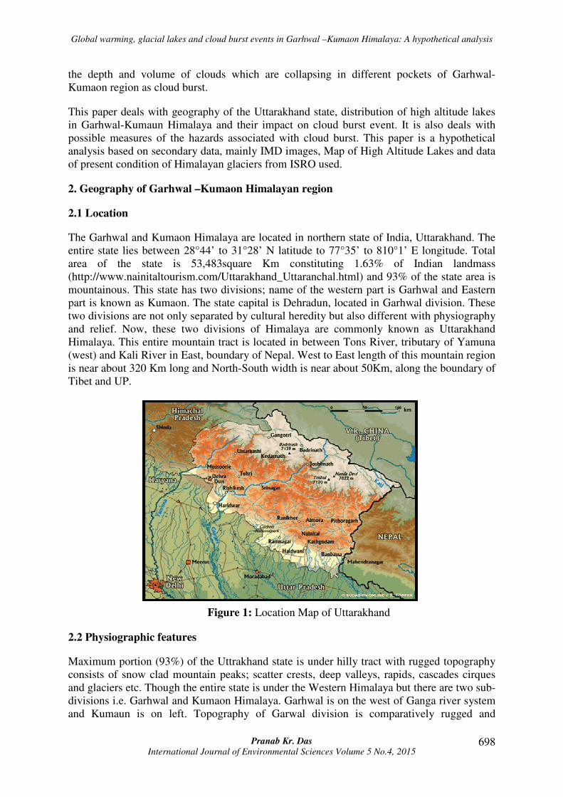
The Garhwal and Kumaon Himalaya are located in northern state of India, Uttarakhand. The
entire state lies between 28°44’ to 31°28’ N latitude to 77°35’ to 810°1’ E longitude. Total
area of the state is 53,483square Km constituting 1.63% of Indian landmass
(http://www.nainitaltourism.com/Uttarakhand_Uttaranchal.html) and 93% of the state area is
mountainous. This state has two divisions; name of the western part is Garhwal and Eastern
part is known as Kumaon. The state capital is Dehradun, located in Garhwal division. These
two divisions are not only separated by cultural heredity but also different with physiography
and relief. Now, these two divisions of Himalaya are commonly known as Uttarakhand
Himalaya. This entire mountain tract is located in between Tons River, tributary of Yamuna
(west) and Kali River in East, boundary of Nepal. West to East length of this mountain region
is near about 320 Km long and North-South width is near about 50Km, along the boundary of
Tibet and UP.
Figure 1: Location Map of Uttarakhand
2.2 Physiographic features
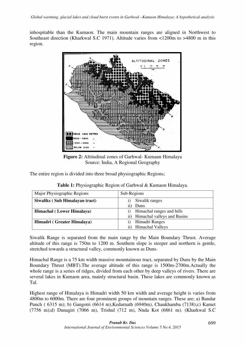
Maximum portion (93%) of the Uttrakhand state is under hilly tract with rugged topography
consists of snow clad mountain peaks; scatter crests, deep valleys, rapids, cascades cirques
and glaciers etc. Though the entire state is under the Western Himalaya but there are two sub-
divisions i.e. Garhwal and Kumaon Himalaya. Garhwal is on the west of Ganga river system
and Kumaun is on left. Topography of Garwal division is comparatively rugged and
Global warming, glacial lakes and cloud burst events in Garhwal –Kumaon Himalaya: A hypothetical analysis
Pranab Kr. Das International Journal of Environmental Sciences Volume 5 No.4, 2015
699
inhospitable than the Kumaon. The main mountain ranges are aligned in Northwest to
Southeast direction (Kharkwal S.C 1971). Altitude varies from <1200m to >4800 m in this
region.
Figure 2: Altitudinal zones of Garhwal- Kumaun Himalaya
Source: India, A Regional Geography
The entire region is divided into three broad physiographic Regions;
Table 1: Physiographic Region of Garhwal & Kumaon Himalaya.
Major Physiographic Regions Sub-Regions
Siwaliks ( Sub Himalayan tract) i) Siwalik ranges
ii) Duns
Himachal ( Lower Himalaya) i) Himachal ranges and hills
ii) Himachal valleys and Basins
Himadri ( Greater Himalaya) i) Himadri Ranges
ii) Himachal Valleys
Siwalik Range is separated from the main range by the Main Boundary Thrust. Average
altitude of this range is 750m to 1200 m. Southern slope is steeper and northern is gentle,
stretched towards a structural valley, commonly known as Duns.
Himachal Range is a 75 km width massive mountainous tract, separated by Duns by the Main
Boundary Thrust (MBT).The average altitude of this range is 1500m-2700m.Actually the
whole range is a series of ridges, divided from each other by deep valleys of rivers. There are
several lakes in Kumaon area, mainly structural basin. These lakes are commonly known as
Tal.
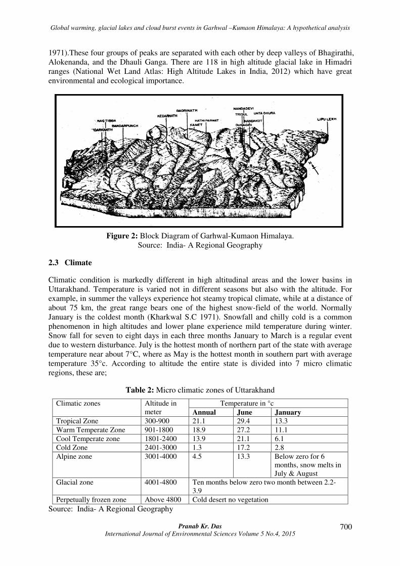
Highest range of Himalaya is Himadri width 50 km width and average height is varies from
4800m to 6000m. There are four prominent groups of mountain ranges. These are; a) Bandar
Punch ( 6315 m); b) Gangotri (6614 m),Kedarnath (6940m), Chaukhamba (7138);c) Kamet
(7756 m);d) Dunagiri (7066 m), Trishul (712 m), Nnda Kot (6861 m). (Kharkwal S.C
Global warming, glacial lakes and cloud burst events in Garhwal –Kumaon Himalaya: A hypothetical analysis
Pranab Kr. Das International Journal of Environmental Sciences Volume 5 No.4, 2015
700
1971).These four groups of peaks are separated with each other by deep valleys of Bhagirathi,
Alokenanda, and the Dhauli Ganga. There are 118 in high altitude glacial lake in Himadri
ranges (National Wet Land Atlas: High Altitude Lakes in India, 2012) which have great
environmental and ecological importance.
Figure 2: Block Diagram of Garhwal-Kumaon Himalaya.
Source: India- A Regional Geography
2.3 Climate
Climatic condition is markedly different in high altitudinal areas and the lower basins in
Uttarakhand. Temperature is varied not in different seasons but also with the altitude. For
example, in summer the valleys experience hot steamy tropical climate, while at a distance of
about 75 km, the great range bears one of the highest snow-field of the world. Normally
January is the coldest month (Kharkwal S.C 1971). Snowfall and chilly cold is a common
phenomenon in high altitudes and lower plane experience mild temperature during winter.
Snow fall for seven to eight days in each three months January to March is a regular event
due to western disturbance. July is the hottest month of northern part of the state with average
temperature near about 7°C, where as May is the hottest month in southern part with average
temperature 35°c. According to altitude the entire state is divided into 7 micro climatic
regions, these are;
Table 2: Micro climatic zones of Uttarakhand
Climatic zones Altitude in
meter
Temperature in °c
Annual June January
Tropical Zone 300-900 21.1 29.4 13.3
Warm Temperate Zone 901-1800 18.9 27.2 11.1
Cool Temperate zone 1801-2400 13.9 21.1 6.1
Cold Zone 2401-3000 1.3 17.2 2.8
Alpine zone 3001-4000 4.5 13.3 Below zero for 6
months, snow melts in
July & August
Glacial zone 4001-4800 Ten months below zero two month between 2.2-
3.9
Perpetually frozen zone Above 4800 Cold desert no vegetation
Source: India- A Regional Geography
Global warming, glacial lakes and cloud burst events in Garhwal –Kumaon Himalaya: A hypothetical analysis
Pranab Kr. Das International Journal of Environmental Sciences Volume 5 No.4, 2015
701
The Monsoon arrives in end of the June and retreats normally in middle of September.
Nowadays, cloud burst during the Monsoon and pre-Monsoon is a regular matter in high
altitudinal area of Garhwal and Kumaon Himalaya. Decreasing trend of annual rainfall (-
29.7—2.1 cm/100 years) has been observed at Srinagar, Mussorie, Mukteshwar and
Joshimath whereas increasing trend at Dehradun, Pauri, Nainital , Almora and Pithoragrah
(3.8 to 28.7 cm/100 year) has been observed in last century ( Borgaonakar et al.1998). Men
temperature of this region has been increased 0.75° C to 1 °C during the last century due to
global warming. (Bajracharya Samjwal Ratna et al 2007).
3. Record of cloud burst events in recent past in Garhwal &Kumaon Himalaya
Cloud bust is an extreme amount of precipitation over a smaller area within a shorter period.
Sometime hail and thunderstorm are associated with it and can create flood or flash flood
conditions causing loss of life and properties. It is observed that during the Cloud Burst the
rate of rainfall can be reached up to 10 cm/hr (Woolley Ralfer, 1946). It is a localized
phenomenon affecting an area not more than 20-30 square km but some time it may be 50
square km. Like the other meso scale weather structures such as tempest, tornado cloud burst
has also shorter life span unlike the tropical cyclone and very difficult to predict. Cloud Burst
is not an uncommon event in Uttarakhand Himalaya. In recent past this region has
experienced several Cloud Burst incidences such as;
Table 3: Record of cloud burst in Uttarakhand, Garhwal-Kumaon Himalaya.
Affected Area Year of
Occurrence
Rate of Destruction
Kedarnath, Rudraprayag
District
14-15th June,2013 10,000 were died and 7000 missing
and several injured
Rudraprayag, Rudraprayag
District
14th
September,2012
39 were people died.
Munisyari, Pithoragarh district 18th August,2010 30 were died and 50 injured
Kapkot village,Bageshwar
District
19th August,2010 18-20 were died, more than 30 missing
Nachni near Pithoragarh
District
7th August,2009 38 were people died.
Near Badrinath Shrine,
Chamoli District
6th July,2006 17 people died and 28 injured
Malpa, Kali Valley of
Kumaun Division
17th August,1998 250 were died including 60 Kailash
Mansarrovar pilgrims
Badrinath Shrine, Chamoli
District
24th July,2004 17 were died and 18 missing
Alakananda river basin July,1970 15,000 were died and 80,000 houses
were destroyed along the bank of
Alakanada.
Source: Wikipedia
4. High altitude lakes and cloud burst event in Garhwal-Kumaon Himalaya
Garhwal-Kumaon Himalaya is a suitable place for cloud burst. Cloud burst is mainly
occurred here in Monsoon. When Monsoon clouds are obstructed in main Himalayan range,
the clouds rose upwards (sometime up to 9 km), form dense Cumulonimbus cloud with wider
base. It is happened due to moist thermodynamic instability and rapid dynamic lifting of
cloud by step topography. Cloudbursts can’t occur only in the Monsoon period but also may
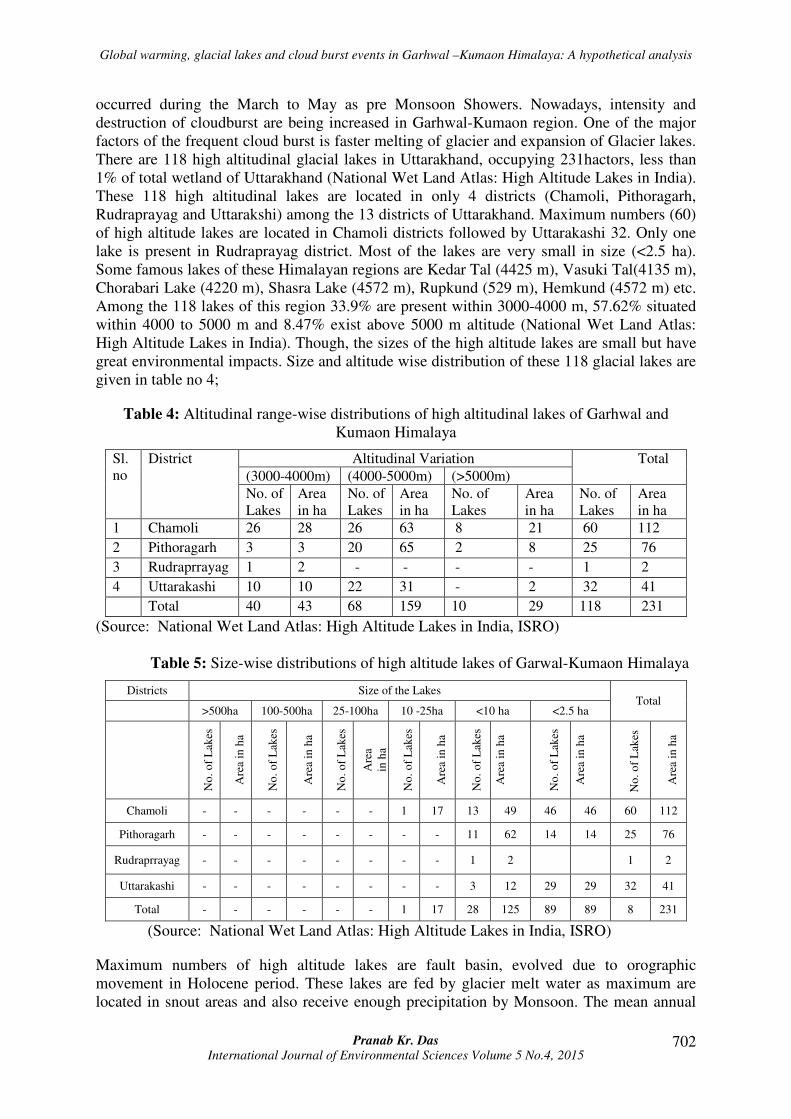
Global warming, glacial lakes and cloud burst events in Garhwal –Kumaon Himalaya: A hypothetical analysis
Pranab Kr. Das International Journal of Environmental Sciences Volume 5 No.4, 2015
702
occurred during the March to May as pre Monsoon Showers. Nowadays, intensity and
destruction of cloudburst are being increased in Garhwal-Kumaon region. One of the major
factors of the frequent cloud burst is faster melting of glacier and expansion of Glacier lakes.
There are 118 high altitudinal glacial lakes in Uttarakhand, occupying 231hactors, less than
1% of total wetland of Uttarakhand (National Wet Land Atlas: High Altitude Lakes in India).
These 118 high altitudinal lakes are located in only 4 districts (Chamoli, Pithoragarh,
Rudraprayag and Uttarakshi) among the 13 districts of Uttarakhand. Maximum numbers (60)
of high altitude lakes are located in Chamoli districts followed by Uttarakashi 32. Only one
lake is present in Rudraprayag district. Most of the lakes are very small in size (<2.5 ha).
Some famous lakes of these Himalayan regions are Kedar Tal (4425 m), Vasuki Tal(4135 m),
Chorabari Lake (4220 m), Shasra Lake (4572 m), Rupkund (529 m), Hemkund (4572 m) etc.
Among the 118 lakes of this region 33.9% are present within 3000-4000 m, 57.62% situated
within 4000 to 5000 m and 8.47% exist above 5000 m altitude (National Wet Land Atlas:
High Altitude Lakes in India). Though, the sizes of the high altitude lakes are small but have
great environmental impacts. Size and altitude wise distribution of these 118 glacial lakes are
given in table no 4;
Table 4: Altitudinal range-wise distributions of high altitudinal lakes of Garhwal and
Kumaon Himalaya
Sl.
no
District Altitudinal Variation Total
(3000-4000m) (4000-5000m) (>5000m)
No. of
Lakes
Area
in ha
No. of
Lakes
Area
in ha
No. of
Lakes
Area
in ha
No. of
Lakes
Area
in ha
1 Chamoli 26 28 26 63 8 21 60 112
2 Pithoragarh 3 3 20 65 2 8 25 76
3 Rudraprrayag 1 2 - - - - 1 2
4 Uttarakashi 10 10 22 31 - 2 32 41
Total 40 43 68 159 10 29 118 231
(Source: National Wet Land Atlas: High Altitude Lakes in India, ISRO)
Table 5: Size-wise distributions of high altitude lakes of Garwal-Kumaon Himalaya
Districts Size of the Lakes Total
>500ha 100-500ha 25-100ha 10 -25ha <10 ha <2.5 ha
No
. o
f L
akes
Are
a in
ha
No
. o
f L
akes
Are
a in
ha
No
. o
f L
akes
Are
a
in h
a
No
. o
f L
akes
Are
a in
ha
No
. o
f L
akes
Are
a in
ha
No
. o
f L
akes
Are
a in
ha
No
. o
f L
akes
Are
a in
ha
Chamoli - - - - - - 1 17 13 49 46 46 60 112
Pithoragarh - - - - - - - - 11 62 14 14 25 76
Rudraprrayag - - - - - - - - 1 2 1 2
Uttarakashi - - - - - - - - 3 12 29 29 32 41
Total - - - - - - 1 17 28 125 89 89 8 231
(Source: National Wet Land Atlas: High Altitude Lakes in India, ISRO)
Maximum numbers of high altitude lakes are fault basin, evolved due to orographic
movement in Holocene period. These lakes are fed by glacier melt water as maximum are
located in snout areas and also receive enough precipitation by Monsoon. The mean annual
Global warming, glacial lakes and cloud burst events in Garhwal –Kumaon Himalaya: A hypothetical analysis
Pranab Kr. Das International Journal of Environmental Sciences Volume 5 No.4, 2015
703
precipitation ranges from 600-1200 mm and 80% of it is occurred in Monsoon (Climate
Himalaya 30th July 2013). The high altitude lakes are very sensitive to climate change. These
lakes are characterized by extreme cold, dry and alpine climatic conditions and covered with
seasonal or diurnal permafrost layer. This high altitude area experience low air pressure and
higher ultraviolet radiation in cloud free conditions. Due to strong solar radiation the volume
of the lakes are expanded with glacier melt water in summer. During winter these lakes are
frozen with snowfall due to western disturbance with presence of extra tropical depression.
The freezing period generally extended from September to April. In such a way the freezing
and melting cycle is generating with mixing of vertical water column.
Figure 3: Distributions of High Altitude Lakes of Uttarakhand
(Source: National Wet Land Atlas: High Altitude Lakes in India, ISRO)
The mean temperature of the planet has been increased 0.75° C during last century and would
be increased 1.4 to 5.8° C due to global warming, resulting faster destruction of mountain or
valley glaciers. (Ray Mukesh et al, 2011) This phenomenon is already witnessed in Himalaya
where glacier and glacial lakes are changing alarmingly. Glacier retreating rate of Himalaya
is 10 to 60 m per year. A well number of small glacier (<0.2 sq km) have already disappeared.
(Ray Mukesh et al, 2011) Some glacial lakes in this region have been increased as high as
800 percent over the last 40years.( Ray Mukesh et al, 2011) At present a series of sub-glacial
ponds are evolving and merging with each other so that glacier are melting faster than the
past.
Global warming, glacial lakes and cloud burst events in Garhwal –Kumaon Himalaya: A hypothetical analysis
Pranab Kr. Das International Journal of Environmental Sciences Volume 5 No.4, 2015
704
Table 6: Present status of Glaciers of Garhwal –Kumaon Himalaya
River Basin Coverage Trend in Glacier Area
Estimation
Status of Studies Glacier
Alakananda
(Satopanth &
Bhagirath Karak
are 2 large glacier
of this basin)
274 glaciers
studied
14% loss in area (During
1962 to 2001 the area of
glaciers was 1047 & 905
Square km respectively)
243 showed retreat
(88.68%), 4 showed no
change, 27 glaciers
advanced.
Glacier retreat for this
basin after 1990 is much
rapid.
Bhagirathi 183 glaciers
studied
11% loss in area (During
1962 to 2001 the area of
glaciers was 1218 & 1074
Square km respectively)
117 showed retreat (64%)
39 showed no change
27 glacier advanced
Glacier retreat has been
slow after 1990
Adjacent but contrasting
trends
Gauri Ganga
(Milam Glacier)
29 glaciers
studied
4% loss in area (During
1962 to 2001 the area of
glaciers was 272 & 261
Square km respectively)
Most glaciers of this basin
slow retreat
Dhauliganga 104 glaciers
studied
16% loss in area
Source: Snow and Glaciers Studies of the Himalayas, Space Application Centre, Ahemdabad
(May 2011); Monitoring done through topgraphic maps of Survey of India by SAC.
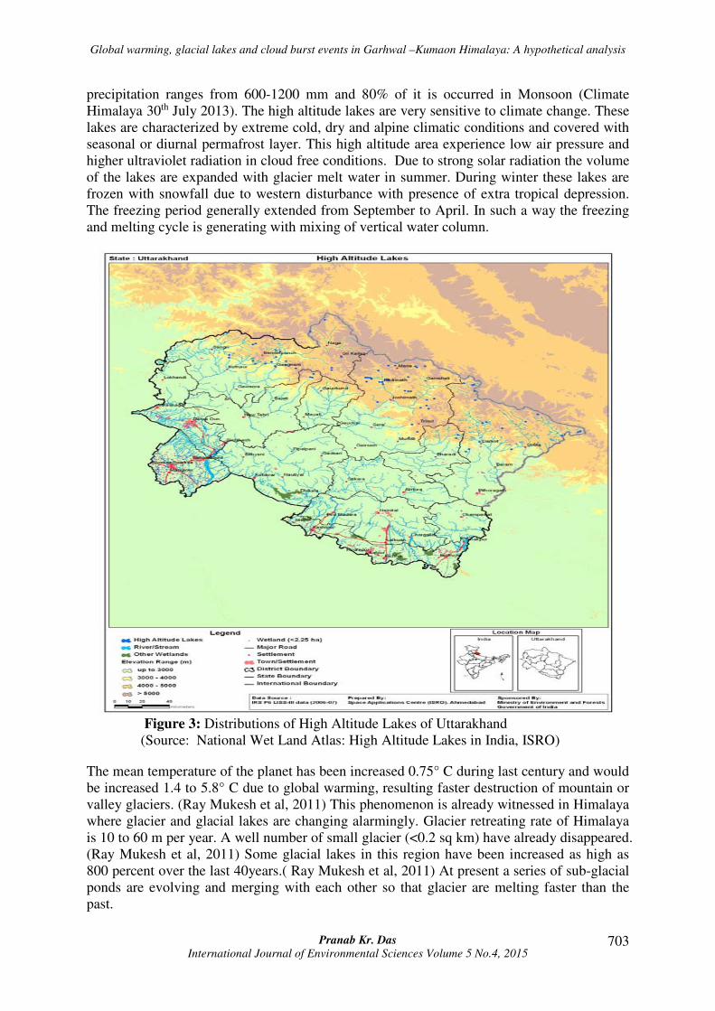
Kedartal in summer Kedartal in winter
This glacier melts water and lake water come direct contact with clouds due to higher altitude.
The temperatures of the glacial lakes are normally below the frizzing temperature. The
saturation vapour pressure over cold (>-5°C) water of lakes remains high (Figure 4). So, the
evaporated water of the lake immediately condenses over the snow droplets of the cloud.
Moreover, the volume and depth of the cloud could be increased within short time by
sublimation process from the freeze lakes or moraine free glaciers in snout areas. Garhwal-
Kumaon region is highly comprises with micaceous Pinjor sediments (Chaudhri A.R, Sing
Mahavir 2012) such as Gneiss, Mica Schist and Garnet Schist, Biotite etc. So, there are
plenty numbers of freezing nuclei (mainly Illite, keolinite) presence in atmosphere due to
excessive weathering and erosion process of these micaceous elements. This freezing nuclei
rapidly freezes small water droplet into ice crystal within 0°C to -40° C temperature and
Global warming, glacial lakes and cloud burst events in Garhwal –Kumaon Himalaya: A hypothetical analysis
Pranab Kr. Das International Journal of Environmental Sciences Volume 5 No.4, 2015
705
cloud become more dense and heavy. In such a way large wide based cumulonimbus cloud
formed. When this heavy cloud moves downwards, become instable due to adiabatic heating
and can be collapsed (as a balloon full of water) with in small portion of area. When this type
of cloud is trapped in a valley, the rate of destruction is become worst. Moreover, the
situation can be more critical with the presence of extra tropical depression like 15th June
2013 (Das Pranab Kr. 2013).
Figure 4: Saturation vapour pressure over water and ice droplets
Source: http://www,geminibv.nl/tidbits/dauwpunt-druk-en-temperatuur?set_language=en
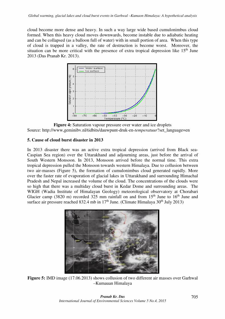
5. Cause of cloud burst disaster in 2013
In 2013 disaster there was an active extra tropical depression (arrived from Black sea-
Caspian Sea region) over the Uttarakhand and adjourning areas, just before the arrival of
South Western Monsoon. In 2013, Monsoon arrived before the normal time. This extra
tropical depression pulled the Monsoon towards western Himalaya. Due to collusion between
two air-masses (Figure 5), the formation of cumulonimbus cloud generated rapidly. More
over the faster rate of evaporation of glacial lakes in Uttarakhand and surrounding Himachal
Pradesh and Nepal increased the volume of the cloud. The concentrations of the clouds were
so high that there was a multiday cloud burst in Kedar Dome and surrounding areas. The
WIGH (Wadia Institute of Himalayan Geology) meteorological observatory at Chorabari
Glacier camp (3820 m) recorded 325 mm rainfall on and from 15th June to 16th June and
surface air pressure reached 832.4 mb in 17th June. (Climate Himalaya 30th July 2013)
Figure 5: IMD image (17.06.2013) shows collusion of two different air masses over Garhwal
–Kumauan Himalaya
Global warming, glacial lakes and cloud burst events in Garhwal –Kumaon Himalaya: A hypothetical analysis
Pranab Kr. Das International Journal of Environmental Sciences Volume 5 No.4, 2015
706
Kedarnath and surrounding areas are under the Pindari Thrust comprises with gneiss, schist
and biotite, extremely affected by physical weathering of kindreded shattering; debris slide-
slump and earth flow etc. But most important is fluvio-glacial erosion. Kedarnath is located
on the paleo-channel or in a narrow immature flood plain in between Mandakini and
Saraswati Rivers; both are originated from Chorabari Lake. During the multiday cloud burst
(14th June to 17th June) million tons of debris, boulders have been carried down with the
collapsed water of Chorabari Lake through Mandakini-Saraswati Rivers as flash-flood.
Continues downpour also increased the rate of landslides in fragile mountains. (Das Pranab
Kr. 2013).
5.1 Conclusion and suggestion
2013 Cloud Burst event was a great lesion. It is very important to predict cloud burst with
proper early warning system. If it would be possible the casualty of life could be minimize.
We have to also normalize the environmental quality in high altitude areas so that mountain
glaciers exist with their beneficial effects. It is true that durability of Glaciers in Grhwal-
Kumaon Himalaya is in threat due to global warming. However, localize factors such as
excessive practice of mass tourism, vehicular movement, human activities in high altitude
eco-sensitive areas also responsible for increasing of temperature and destruction of glaciers.
With the implementation of some techniques, rules and regulation intensity and vulnerability
of cloud burst and associated hazards could be minimized
1. It is difficult to forecast a mesoscale weather phenomenon especially cloudburst. But
to some extent, now it is possible. But it requires high-resolution numerical models
and mesoscale observation equipments such as of high performance computer,
Doppler Weather Rader (DWR), Automatic Weather Station (AWS), Radiosonde /
Rawinsond (RS/RW) etc (Das Someshwar et al, 2006). These observation equipments
can be installed in every sub divisional towns for high resolution measurement (>10
km) of vertical profiles and parameters of atmosphere. This entire model works in
NOWCAST mode only i.e. few hours in advance. So, education and tanning of the
local administration should be incorporated for preparation within short notice that
helps mitigation of the disaster.
2. For continues monitoring the glacier, more observatory centers should be establish in
snout areas with Automatic Weather Station (AWS) and data from the AWS should
be generated and studied in a mother station with a regular interval. In this context,
WIGH is doing excellent job. However, number of observatory centers should be
increased immediately.
3. With the early warning system, effective evacuation plans and responsive disaster
management group should be prepared with the proper guidance and assistance with
National Disaster Management Authority (NDMA). These groups can be deployed
block wise with active Participation of local inhabitants (Das Pranab Kr. 2013).
4. There should be strict restriction on mass tourism in Eco-sensitive zones especially in
Char Dhams, Valley of Flowers, Hemkund Sahib and several glaciers and snouts
areas. Annual quota of tourists or pilgrims should be introduced in these areas like
Kailash –Manasarovar Yatra.
5. Considerable amount of environmental tax must be imposed on tourists and vehicles
to regulate the influx vehicular movement in high terrain areas.
Global warming, glacial lakes and cloud burst events in Garhwal –Kumaon Himalaya: A hypothetical analysis
Pranab Kr. Das International Journal of Environmental Sciences Volume 5 No.4, 2015
707
6. The state authority can imposed restriction in night halt in eco sensitive zones. If it
will be possible, the emulsion of green house gases and melting rate of the glacier in
snout areas could be minimized. Spreading of pollutants such as plastics, other solid
waste and chemicals could be less with this restriction in catchment area of the river
basins.
7. Awareness programmes must be enhanced within the tourists and pilgrims to
normalize the environment of high terrine areas. Well trained local people can play an
important role in this programme.
8. Heavy Duty vehicles should be prohibited in slide porn areas and regular monitoring
should go on with the probation of fine. Annual quota could be introduced for
registration of all types of vehicles to regulate the new vehicle. All the vehicles that
are older than 10 years should be ban for better air quality throughout the state.
9. It is observed that the transport syndicate or agencies of UP and Delhi, surrounding
states, operate the vehicle for Char Dham Yatra and mass tourism and they illegally
operate more vehicles than their authorized permission. The transport syndicates or
agencies from outside of Uttarakhand should be banned or restricted with probation of
state wise quota. The illegal transport syndicate or agencies should be ban
permanently in case of violation of terms and conditions.
Acknowledgements
While preparing this paper, first of all I wish to express my sincere thanks to Space
Application Centre, ISRO, Ahmadabad and Ministry of Environment and Forest, Govt. of
India for National Wet Land Atlas: High Altitude Lakes in India and Snow and Glaciers
Studies of the Himalayas, these two technical reports help to understand the present status of
high altitude lakes and glaciers of Garhwal-Kumaon region and their environmental
conditions. I am also acknowledging Samjwal Ratna Bajracharya at el. Ralfar Woolley, A.R
Chaudhuri et al. Sowmeshwar Das et al. for their respective research paper and articles which
are used in paper for different data and information. I am grateful to Dr. R.L Sing, the editor
of the book, India- A regional Geography; this book helped me to write the Geography of
Garhwal-Kumaon Himalaya.
6. References
1. Bajracharya Samjwal Ratna et al. Impact of climate change on Himalayan glaciers
and glacial lakes: Case studies on GLOF and associated hazards in Nepal and Bhutan,
ICIMOD 2007 available as www.icimod.org/resource/216 accessed on 10.02.2014
2. Chaudhri A.R, Sing Mahavir., (2012), Clay minerals as climate change indicators- A
case study, American journal of climate change, pp 231-239.
3. Das Pranab Kr. (2013), The Himalayan Tsunami- Cloudburst, Flash Flood & death
toll: A geographical postmortem, IOSR-JESTFT, pp 33-45
4. Das Someshwar et al, (2006), Simulation of a Himalayan cloudburst, Journal of Earth
system sciences, 115(3), pp 299–313.
5. Nainital Tourism, available at http://www.nainitaltourism.com/Uttarakhand
_Uttaranchal.html, accessed on 25.02.2014.
Global warming, glacial lakes and cloud burst events in Garhwal –Kumaon Himalaya: A hypothetical analysis
Pranab Kr. Das International Journal of Environmental Sciences Volume 5 No.4, 2015
708
6. Kedarnath Disaster: Facts and plausible by climate Himalaya 30th July 2013 available
http://chimalaya.org/2013/07/30/kedarnath-disaster-facts-and-plausible-causes/
accessed on 14.09.2013.
7. Kharkwal S.C India a regional geography, National geographical society of India,
editor Sing. R.L, Varanashi-5, UBS Publishers’ Distributers Pvt. Ltd, Reprinted in
2008, ISBN: 978-81-85273-18-1.
8. National Wet Land Atlas: High Altitude Lakes in India, Sponsored by Ministry of
Environment and Forests, Government of India, Space applications centre, ISRO,
Government of India, Ahmedabad – 380 015, September, 2012.
9. Ray Mukesh et al, Climate Vulnerability in North Western Himalayas, Environmental
Trust 6th August, 2011 available as http://www.ced.org.in/docs/inecc/
member_reports/Climatevulnerabilityrs2508.pdf accessed on 23.02.2014
10. Snow and glaciers studies of the Himalayas, Joint project by ministry of environment
and forest ad ministry of space, Published from space application centre, ISRO,
Government of India, Ahmadabad, May 2011
11. Woolley Ralfer – Cloudburst Floods in Uttah 1850-1938, United States Government
Printing Office, Washington: 1946 pp 2.