Embed Size (px)
Citation preview
Space Policy 19 (2003) 265–276
ARTICLE IN PRESS
*Correspondin
4293.
E-mail addres
0265-9646/$ - see
doi:10.1016/j.spa
Global Monitoring for Environment and Security: data policyconsiderations
Ray Harris*, Richard Browning
Department of Geography, University College London, 26 Bedford Way, London WC1H 0AP, UK
Abstract
Data policy is an important element of the initiative on Global Monitoring for Environment and Security (GMES), which aims to
establish a European capacity for the provision and use of operational information for monitoring and management of the
environment and civil security by 2008. This paper documents the data policies of the variety of information providers likely to be
involved in GMES, identifies the obstacles and draws conclusions on ways to improve data policy coherence. It addresses the main
policy issues associated with Earth observation data, as well as with other types of environmental data.
r 2003 Elsevier Ltd. All rights reserved.
1. Introduction
1.1. Aims and objectives
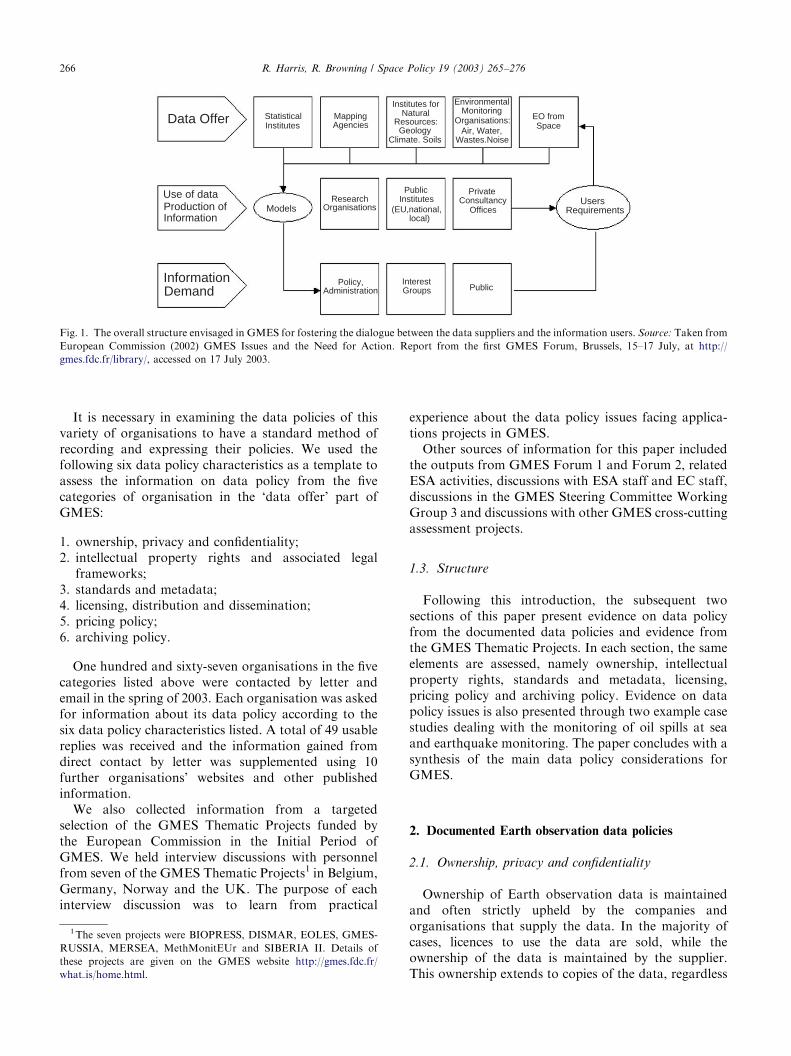
The initiative on Global Monitoring for Environmentand Security (GMES) is aimed at the establishment by2008 of a European capacity for the provision and use ofoperational information for monitoring and manage-ment of the environment and for civil security [1]. Theinitial period of GMES contributes to this long-termaim by understanding what is needed, by consolidatinguser requirements and by implementing an evolutionaryapproach to the development of GMES.One way of summarising GMES that has been widely
used is shown in Fig. 1. It represents a way ofintegrating the environmental and supporting dataavailable, through the stage of using the data in modelsand also empirically to produce information that isrequired by the users in the information demand level ofFig. 1. As for all projects involving the use of Earthobservation data, however, there is currently a lack ofcoherence in policy governing its access and utilisation.An important part of GMES lies in ensuring that thewide variety of information summarised in the ‘dataoffer’ line in Fig. 1 can be exploited in a coherentfashion. There are clear data policy obstacles toallowing the integration of the information in the ‘data
g author. Tel.: +44-20-7679-4283; fax: +44-20-7679-
s: [email protected] (R. Harris).
front matter r 2003 Elsevier Ltd. All rights reserved.
cepol.2003.08.004
offer’ line. Different approaches to legal protection,different data formats, standards, metadata, distribu-tion, pricing and archiving mean that there are oftenobstacles to the successful use of a variety of Earthobservations and terrestrial information in applicationsprojects. It is essential for the use of the data and theproduction of information that the data in the ‘dataoffer’ section can be used together coherently. Thispaper focuses primarily on the data policies of theorganisations associated with Earth observation fromspace, as noted in the data offer line of Fig. 1.The overall aims of this paper are to document the
data policies of the variety of information organisationsfor GMES as summarised in Fig. 1, to identify theobstacles and to draw conclusions on the state ofprogress in data policy for GMES. The emphasis is onthe Earth observation data, but not to the exclusion ofother data sources.
1.2. Methodology
We collected information on and assessed the datapolicies of the following categories of organisationrelevant to GMES:
* statistical institutes;* mapping agencies;* institutes for natural resources;* environmental monitoring and regulation bodies;* Earth observation organisations.
ARTICLE IN PRESS
Data Offer StatisticalInstitutes
MappingInstitutes for
NaturalResources:Geology
Climate. Soils
EnvironmentalMonitoring
Organisations:Air, Water,
Wastes.Noise
EO fromSpaceAgencies
Use of dataProduction ofInformation
ModelsResearch
Organisations
PublicInstitutes
PrivateConsultancy
OfficesUsers
Requirements
InformationDemand
Policy,Administration
InterestGroups Public
(EU,national,local)
Fig. 1. The overall structure envisaged in GMES for fostering the dialogue between the data suppliers and the information users. Source: Taken from
European Commission (2002) GMES Issues and the Need for Action. Report from the first GMES Forum, Brussels, 15–17 July, at http://
gmes.fdc.fr/library/, accessed on 17 July 2003.
R. Harris, R. Browning / Space Policy 19 (2003) 265–276266
It is necessary in examining the data policies of thisvariety of organisations to have a standard method ofrecording and expressing their policies. We used thefollowing six data policy characteristics as a template toassess the information on data policy from the fivecategories of organisation in the ‘data offer’ part ofGMES:
1. ownership, privacy and confidentiality;2. intellectual property rights and associated legalframeworks;
3. standards and metadata;4. licensing, distribution and dissemination;5. pricing policy;6. archiving policy.
One hundred and sixty-seven organisations in the fivecategories listed above were contacted by letter andemail in the spring of 2003. Each organisation was askedfor information about its data policy according to thesix data policy characteristics listed. A total of 49 usablereplies was received and the information gained fromdirect contact by letter was supplemented using 10further organisations’ websites and other publishedinformation.We also collected information from a targeted
selection of the GMES Thematic Projects funded bythe European Commission in the Initial Period ofGMES. We held interview discussions with personnelfrom seven of the GMES Thematic Projects1 in Belgium,Germany, Norway and the UK. The purpose of eachinterview discussion was to learn from practical
1The seven projects were BIOPRESS, DISMAR, EOLES, GMES-
RUSSIA, MERSEA, MethMonitEUr and SIBERIA II. Details of
these projects are given on the GMES website http://gmes.fdc.fr/
what is/home.html.
experience about the data policy issues facing applica-tions projects in GMES.Other sources of information for this paper included
the outputs from GMES Forum 1 and Forum 2, relatedESA activities, discussions with ESA staff and EC staff,discussions in the GMES Steering Committee WorkingGroup 3 and discussions with other GMES cross-cuttingassessment projects.
1.3. Structure
Following this introduction, the subsequent twosections of this paper present evidence on data policyfrom the documented data policies and evidence fromthe GMES Thematic Projects. In each section, the sameelements are assessed, namely ownership, intellectualproperty rights, standards and metadata, licensing,pricing policy and archiving policy. Evidence on datapolicy issues is also presented through two example casestudies dealing with the monitoring of oil spills at seaand earthquake monitoring. The paper concludes with asynthesis of the main data policy considerations forGMES.
2. Documented Earth observation data policies
2.1. Ownership, privacy and confidentiality
Ownership of Earth observation data is maintainedand often strictly upheld by the companies andorganisations that supply the data. In the majority ofcases, licences to use the data are sold, while theownership of the data is maintained by the supplier.This ownership extends to copies of the data, regardless
ARTICLE IN PRESSR. Harris, R. Browning / Space Policy 19 (2003) 265–276 267
of the form or media on which the original and copiesmay exist.Privacy and confidentiality regarding Earth observa-
tion data has become a more important issue as thespatial resolution of satellite data has improved.DigitalGlobe and Space Imaging, which operate thehigh-resolution Quickbird and Ikonos satellites respec-tively, are subject to scrutiny by the US government toensure that sensitive information is not released tounauthorised parties. There are policies in place thatallow the US government to restrict the distribution ofimagery where national security is at risk or where USassets overseas may be placed at risk. In terms of foreignaccess to US commercial remote sensing systems, the USgovernment takes into account ‘the overall relationship,particularly the defence and defence trade relationshipwith the proposed recipient nation, and broader USnational security, foreign policy and economic objec-tives’.2 Sensitive or advanced remote sensing data areonly approved for export on the basis of government-to-government agreements which include end-use andretransfer assurances that protect US-controlled techni-cal data and broader national security issues. Inaddition, it is prohibited for satellite operators to releaseimagery within 24 h of collection so that US forces canexercise standard operational security.3
2.2. Intellectual property rights and associated legal
frameworks
The intellectual property rights and copyright restric-tions on Earth observation data are generally strictlyupheld by the data suppliers. In cases where data or aderived product are placed in the public domain, propercopyright must be conspicuously marked and the datamust not be redistributed without permission. Suchcopyright restrictions generally arise from the commer-cial value of the data, which the data supplierorganisations could potentially lose through un-authorised distribution. Reproduction and redistribu-tion of data are therefore only permitted within theorganisation of the data use and according to the termsset out in licensing agreements.Earth observation data recorded primarily for scien-
tific research, rather than commercial purposes, gener-ally have more relaxed policies regarding intellectualproperty rights. For example, some datasets producedby US federal agencies, for example NASA and NOAA,can be acquired and redistributed with few restrictions,as long as the user correctly acknowledges the datasource.
2US Commercial Remote Sensing Policy, 25 April 2003, http://
www.fas.org/irp/offdocs/nspd/remsens.html.3Source: Digital Globe Product Release Policy Overview, http://
www.digitalglobe.com/
2.3. Standards and metadata
The standards regarding the Earth observation datadepend upon the platform from which the data originateand the organisation responsible for supplying the data.For example, Radarsat International products arecalibrated during processing to provide both geometricand radiometric corrections to the data and to ensurecompliance with Radarsat’s image quality specifications.However, data processed at other Radarsat networkstations may not be calibrated to the same standards,which are defined by levels of certification.In terms of the standards in spatial resolution,
commercial organisations such as DigitalGlobe andSpace Imaging offer the highest spatial resolutionsatellite data commercially available. Quickbird andIkonos data are all supplied with image metadata.Similarly, NASA ensures that its data archives
provide easily accessible information about data hold-ings, including descriptive metadata, quality assess-ments, supporting ancillary information and assistancein locating and obtaining the data. Landsat 7 metadataincludes location and spatial coverage of the digitalimage data, acquisition date, associated file content anddata quality.4
2.4. Licensing, distribution and dissemination
The use of the Earth observation data is generallygoverned by the use of licensing that controls itsdistribution and dissemination. Data suppliers thatoperate on a fully commercial basis, such as SpaceImaging and DigitalGlobe, generally have morerestrictive licensing arrangements regarding the use oftheir data. By comparison, data that are recorded forscientific and research purposes by organisations such asNASA are often freely available with fewer restrictions.DigitalGlobe and Space Imaging offer a variety of
licences for the use of their data, which generally varyaccording to the number of people who propose to usethe data (single or multiple organisation licences forexample). These licences offer varying standards offlexibility in image sharing and redistribution. High-resolution satellite data from Space Imaging andDigital Globe are delivered on CD-ROM, DVD orelectronically.The conditions attached to data supplied by the
European Space Agency depend on the use of the data,which falls into two categories: research and applica-tions development, and operational and commercial use.Data for research and applications development aresupplied directly by ESA from its own facilities, whiledata for commercial use are supplied by ‘distributing
4Source: Landsat 7 Data Policy, 1994, revised 1997, http://
geo.arc.nasa.gov/sge/landsat/l7policyn.html
ARTICLE IN PRESSR. Harris, R. Browning / Space Policy 19 (2003) 265–276268
entities’ selected by ESA.5 These distributing entitiesthen establish their own data distribution scheme bydefining prices and negotiating contracts and sub-licences.Some Earth observation data are provided with very
few restrictions and licensing conditions. For example,NASA products such as QuikSCAT data and MODISdata are provided free of charge for scientific andeducational use, with virtually no restrictions. Similarly,the NASA Earth Science Enterprise follows a policy offull and open sharing of Earth science data obtainedfrom US government funding, as soon as the databecome available. This policy is based on the view thatthe greater the availability of data, the more quickly andeffectively the user community can utilise the informa-tion to address the basic Earth science questions andprovide the basis for developing innovative and practicalapplications to benefit the general public.6 The onlyconditions that govern the use of such data are thatthey are not redistributed for profit and that appro-priate acknowledgements are made in any resultingpublications.In some cases, distribution of Earth observation data
is governed by international agreements. For example,6-hourly Meteosat products are available to all usersworld-wide on a free and unrestricted basis as ‘essential’data and products in accordance with WMO Resolu-tion 40.7
2.5. Pricing policy
The price of the Earth observation data is oftendependent on whether the data in question are to beused for commercial or research purposes. For example,ESA supplies ERS data at or near the cost ofreproduction for research purposes that meet its missionobjectives. For commercial purposes, data are suppliedat a market price that is determined by the variousdistributing entities. Other publicly funded organisa-tions such as NASA offer a large amount of data free ofcharge via the Internet, with little or no restrictionsregarding its use.Data supplier organisations that operate on a wholly
commercial basis, such as Space Imaging and Digital-Globe, supply their data at the market price. This pricecan often be quite substantial (around US$6000 perscene for Quickbird imagery8), which reflects such data’shigh spatial resolution and accuracy.Differences in price for Earth observation data vary
according to the resolution and coverage of particular
5Source: The Envisat Data Policy, 1998, http://envisat.esa.int/6Source: NASA Earth Science Enterprise Statement on Data
Management, http://www.earth.nasa.gov/visions/data-policy.html7Source: Eumetsat Data Policy, 2001, http://www.eumetsat.de/8Source: Quickbird Imagery Products Commercial Pricing, 2002,
http://www.digitalglobe.com/products/ordering.shtml
sensors, because of the different types of application ofthe data. The economic conditions for broad and limitedcoverage systems are not equivalent, resulting indifferent pricing approaches to high-resolution commer-cial data such as Ikonos when compared with a systemsuch as Landsat. When Landsat data were commercia-lised in the 1980s, the price of the data significantlyinhibited users from using it, and they turned to lowerresolution, free AVHRR data for global studies [2].Data that are primarily of use to scientific research fieldsand for which there is not a clearly defined market aretherefore often supplied at the cost of dissemination,particularly if they are produced by a publicly fundedbody such as NASA.
2.6. Archiving policy
Most organisations involved in Earth observationarchive their data, and the nature of the data sets meansthat the archive is in digital form. The accessibility ofarchived data often depends on the length of the missionand the age of the data. For example, Ikonos waslaunched in 1999 and Space Imaging maintains anextensive archive of data since this time. By comparison,Eumetsat holds data covering a time span of over 20years, during which the technology and media by whichdata are stored have been significantly updated. Datarecorded since December 1995 are stored on digitallinear tape. This is a different format to that used earlier,and the same retrieval mechanism cannot be used fordata from before this date. A project to transfer the olddata onto the new format is currently under way, butwill take some years to complete.
3. Evidence from the GMES Thematic Projects
3.1. Ownership, privacy and confidentiality
Where an organisation is responsible for capturingdata then ownership is clear, for example with labora-tories that measure methane concentration in airsamples. A similar situation can be claimed for aerialphotography when an organisation commissions andpays for an air photography campaign, and then ownsthe photographs or digital scanner data. In theOceanides project, for example, the ownership of thedata produced by the project itself lies with the projectmembers, although the project members note that thedata cannot be used for commercial purposes.Some difficulties arise when projects use environmen-
tal data captured by others, which is commonly the casein projects that use Earth observation data. The ownersof Earth observation data, like ESA or SPOT Image,grant a licence to use the data and do not conveyownership of the data to the purchaser. A clear example
ARTICLE IN PRESSR. Harris, R. Browning / Space Policy 19 (2003) 265–276 269
of this is in the following extract from the licenceagreement for access to the Shuttle Radar TopographyMission (SRTM) data available from the GermanAerospace Centre DLR.9
1. The SRTM/X-SAR products are protected by inter-national copyright laws.
2. The licence includes the delivery of height and imagedata as well as the medium of delivery and permitsuse of one copy only of the product. The copyrightand the data themselves remain the property of DLR.
The European CORINE land cover data set is a goodexample of uniform ownership and consequent access.For the highest level (25 ha polygons), the provision ofdata used to be covered by national policies, nationalownership and national copyright. This situation hasimproved with the new Europe-wide CORINE licenceagreement, at least for research use of the CORINE landcover data.The conditions of ownership typically restrict access
to certain uses. This has given rise at the EuropeanCommission Joint Research Centre (JRC) to someenvironmental databases held there that are directlyrelevant to other research projects at the JRC but arenot accessible because they fall outside the accessconditions.Apart from the ownership of databases, it is
important to recall the need for access to data forcalibration and validation purposes, and this can giverise to difficulties of privacy. For example, oil slickmonitoring using satellite SAR data may oftenrequire validation data held by oil companies; theseoil companies keep much of their relevant dataprivate, and so the opportunity for validation may befrustrated.A further complication is the possibility of competi-
tion, real or perceived. The Marine Institute in Greeceneeds access to atmospheric forecasts as boundaryconditions for their ocean models. The European Centrefor Medium Range Weather Forecasting (ECMWF)is the best available source of these forecasts, but only6-hourly products are available outside the Europeannational meteorological services. The Marine Institutein Greece has asked for higher temporal resolution datafrom the Greek meteorological service, but there aresome difficulties because of the possible development ofcompetitive weather forecasts.
3.2. Intellectual property rights
The meteorological and oceanographic communitieshave made good progress with intellectual propertyrights (IPR) to encourage data sharing. In the case ofmeteorology, the World Meteorological Congress at its
9http://www.dfd.dlr.de/srtm/produkte/lizenzbestimmungen en.htm
meeting in June 1995 adopted WMO Resolution 40which provides for free and unrestricted access to near-real-time meteorological data [3]. The core policy ofResolution 40 notes:
As a fundamental principle of the World Meteor-ological Organization (WMO), and in consonancewith the expanding requirements for its scientific andtechnical expertise, WMO commits itself to broad-ening and enhancing the free and unrestrictedinternational exchange of meteorological and relateddata and products.
The resolution then expands on the policy by givingguidelines to WMO member states on the practice of theresolution, including:
Members shall provide on a free and unrestrictedbasis essential data and products which are necessaryfor the provision of services in support of theprotection of life and property and the well-being ofall nations, particularly those basic data and productsas y required to describe and forecast accuratelyweather and climate, and support WMO pro-grammes.
A similar situation exists for oceanographic data withthe International Oceanographic Commission (IOC), atleast for data relating to the open ocean.10
There are, however, some obstacles to sharing of datain the coastal seas, such as the North Sea. Somebiochemical data are sensitive and not shared, such asthose on eutrophication associated with pollutiondischarges or on the effects of accidental nucleardischarges into the sea. Data streamlining and openaccess is less mature for the shelf seas than for the openocean, and this is particularly relevant to the majorEuropean seas, namely the Mediterranean Sea, theBaltic Sea and the North Sea.
3.3. Standards and metadata
Within the subject of standards and metadata, thereare three key themes that emerge:
1. the technical file formats and data storage standards;2. the standards that apply to the quality of the data asrepresentations of reality;
3. the standards that relate to the procedures forinformation creation.
There is no convergence on standard ways of holdingand transferring environmental data in the GMESThematic Projects. While there is some trend to makedata available in proprietary formats, for exampleArcView, ERDAS Imagine or ENVI formats, there is
10 IOC oceanographic data exchange policy: http://ioc.unesco.org/
iocgov/ioc21/documents/INF-1163.doc
ARTICLE IN PRESSR. Harris, R. Browning / Space Policy 19 (2003) 265–276270
much evidence of projects creating their own ways ofholding data. This can be as simple files containing rowsand columns of byte data or it can be projects writingtheir own programmes. The MERSEA project, forexample, uses the Network Common Data Format(NetCDF) because of its advantages for handling flowsof data across the Internet. NetCDF is widely compa-tible with other projects and data systems, for examplewith the Global Ocean Data Assimilation Experiment(GODAE) and the Argo ocean buoy network ofprofiling floats.11 NetCDF may well emerge as astandard for oceanographic applications, although itsapplication for terrestrial applications cannot be readilyforeseen.In many sectors of environmental science, including
Earth observation, there are examples of good practicein calibration and validation. However, the proceduresfor generating environmental information and knowl-edge from raw data have not yet reached maturity in allsectors. The procedures used by Norway and the UK toidentify oil slicks in satellite Earth observation imagedata of the North Sea are different. Where aircraft dataare used to monitor the oil slicks, the characteristics ofthe aircraft and its sensor can have a substantial impacton slick detectability: different aircraft and sensors areused in Germany and France, for example. If aircraftperform other tasks, such as a coastguard function, thedetailed information on location and other supportingdata may be confidential and not made available toscientific users. In terrestrial applications, the use ofproprietary Geographic Information Systems (GIS) isincreasingly common, but the data used in these systemsmay not be geometrically compatible. For example, theEOLES project found that the superposition of vectordata from different sources of coastlines and basins in aGIS showed that the data were not coincident. Theproblem is often increased when Earth observation dataare included in a GIS.Some meteorological data sets suffer from problems
of discontinuity. The SIBERIA II project reports that inRussia many meteorological stations are closing, whichmeans a poorer quality meteorological data set becauseof the loss of the time series. Meteorological andhydrological data produced by Russia used to be a richsource of environmental information, but that richnessis now reducing because of the closure of some recordingstations. Instead of Russian sources, the SIBERIA I andSIBERIA II projects have used meteorological data of
11Argo is an international effort to implement an array of 3000
autonomous (free-drifting) temperature/salinity floats as a major
component of a global ocean observing system. Argo floats measure
temperature, salinity, pressure and reference velocity together with sea
surface height from satellite altimetric data.
the Siberia region from sources in the UK and theUSA.12
One approach to standards is to have a free-formapproach, but to place emphasis on putting datadescriptors in the metadata. While this approach maybe attractive for mature users, the size of the metadatamay be very large and so flood the normal user withmore metadata than he/she can fruitfully use.In the Earth observation sector, there is some
convergence of standards, at least for terrestrialapplications. Common standards in widespread useinclude GeoTIFF and JPG image data formats, andthe work of the OpenGIS Consortium offers a wayforward for integration of data from a variety ofsources. CORBA offers commercial off the shelf(COTS) software to develop the middleware needed todevelop distributed data systems.
3.4. Licensing, distribution and dissemination
The conditions attached to the distribution of ESAEarth observation data depend on the use of the data.The following two categories of use have been definedby ESA.
Category 1 use. Research and applications develop-ment use in support of the mission objectives,including research on long-term issues of Earthsystem science, research and development in prepara-tion for future operational use, certification ofreceiving stations as part of the ESA functions, andESA internal use.Category 2 use. All other uses which do not fall intocategory 1 use, including operational and commercialuse.
In preparing this division of uses, the ESA memberstates foresaw a clear distinction between the pre-operational use of ESA Earth observation data andthe operational use of the data. In practice, thetransition from pre-operational use (or preparation forfuture operational use) and operational use is not asclear as was first thought. Some operational systemshave a mix of fully operational elements and elementsthat are in the research and development phase. Thismay be a generic challenge for GMES as a whole as itplans to develop operational services by 2008: it willrequire a managed transition from the current fundingof research and development projects to a sustainablesystem of operational services.Data from the Shuttle Radar Topography Mis-
sion (SRTM) are a valuable source of topographic
12Climatic Research Unit at the University of East Anglia—http://
www.cru.uea.ac.uk/ and the University Corporation for Atmospheric
Rsearch (UCAR) in Boulder, CO, USA—http://www.ucar.edu/ucar/
ARTICLE IN PRESSR. Harris, R. Browning / Space Policy 19 (2003) 265–276 271
information for the land surfaces of the globe between55�N and 55�S.The SRTM data have the following accuracy char-
acteristics:13
* absolute horizontal accuracy: 720m,* relative horizontal accuracy: 715m,* absolute vertical accuracy: 716m,* relative vertical accuracy: 76m.
For users in Russia, these characteristics make thedata fall, in principle, within the limit of confidentialmap data controlled by Roskartografia and the FederalSecurity Service. Potential Russian users, includingRussian principal investigators and partners in Eur-opean Commission projects who have the right to dataat no cost, are deterred from placing orders for RussianSRTM products as the data are perceived as fallingwithin the guidelines of state confidentiality.Catalogue systems for describing Earth observation
data holdings have improved considerably in the past 10years. An example of good practice is the ESAODISSEO catalogue system.14 Because environmentalresearch and applications projects require data from avariety of sources, there is great merit in providingfront-end catalogue systems to a variety of datacatalogues to provide easy user access to Earthobservation and other environmental data. The INFEOsystem15 is an example of good practice to provide suchmultiple catalogue access.
3.5. Pricing policy
Earth observation data are largely regarded as beingtoo expensive. From a user’s point of view, data areexpensive because their costs often either make up asubstantial proportion of a project’s budget or wouldmake up a substantial proportion if the data were notprovided for free. The SIBERIA I and II projects, forexample, have been provided with data free of chargeonly because of the projects’ participation in Announce-ment of Opportunity programmes which provide data atno cost. From a supplier’s point of view, the cost of datais typically only sufficient to capture the marginal cost ofdata provision for government agencies, or in the case ofcommercial providers such as Space Imaging to capturethe real cost of data collection. There is no Earthobservation data provider making a profit from datasales to the civilian sector. Thus, the perception ofwhether Earth observation data are expensive or notdepends on the position of the viewer.In order to develop and test fully the procedures and
techniques that could be useful for an operational
13Source: http://www.dfd.dlr.de/srtm/produkte/produkte en.htm14http://odisseo.esrin.esa.it/15http://www.infeo.org/cgi-bin/fw/FCH main
GMES research system, projects need to use more datathan just single images. For example, the MERSEAproject needs daily SAR data of the North Sea, which ata cost of (say) h100 per scene means a total annualspend of h36 500. While this annual figure for a robustoperational programme is not necessarily large, the costfor a research project that is developing the features ofoperational systems is significant. In addition, thisshould be set in the context of most in situ oceano-graphic data being made available for free. The pricingpolicy issues of operational systems are challenges forthe transition within GMES from support of research tosupport of sustainable operational services.The situation with non-Earth observation data is very
varied, both by data type and by country. While aerialphotography can be expensive, there is the benefit ofowning the data, whereas for high spatial resolutionsatellite data, the high cost covers only a licence to use thedata rather than full ownership of it. However, high spatialresolution data are available for most of the land surfaceof the globe, while the acquisition of aerial photography issubject to gaining overflight rights of a territory.
3.6. Archiving policy
Some archives of environmental data are in goodcondition and thought of highly by the user community,for example Landsat data, CORINE land cover dataand some aerial photography. Other archives sufferfrom a lack of a clear policy or from data discontinuity.The ERS SAR data are archived as raw data, but thereare only partial product archives.One lesson from environmental science of the past 20
years is the need to be able to reprocess data whenmodels are improved or new analysis models generated.Because of the new gravity field data from the GravityField and Steady-State Ocean Circulation Mission(GOCE) and from the Gravity Recovery and ClimateExperiment (GRACE), all radar altimeter data willbenefit from reprocessing to produce a robust 20-yearproduct of mean surface ocean height. It is likely that inthe future it will be necessary to reprocess data setsroughly every 10 years in the light of new scientificadvances.Reliable long-term archives are essential for climate
change analysis and for practical applications projectssuch as land subsidence and land cover change analysis.While the cost of a data archive can be calculated easily,the benefit is less easy to quantify. Schreier [4] hassuggested that an archive-to-benefit cost ratio (ABCR)could be calculated for environmental data archives. Hisformulae show the following results:
1. The longer the time to keep the data compared to thereal archive life, the higher the ABCR and thus themotivation for sponsors to fund the archive.
ARTICLE IN PRESSR. Harris, R. Browning / Space Policy 19 (2003) 265–276272
2. The following positively influence the ABCR further:
* a greater investment in science;* a greater profit from data sales;* a greater portion of the overall mission costs donatedto post-mission archives.
All in relation to the overall archive costs.More work on archive value and the benefits that can
be achieved from good quality archives is needed, forexample to evaluate the ABCR concepts.
4. Evidence from examples
4.1. Introduction
Suppliers of data often follow set guidelines andpolicies to distribute their data, but it is sometimes moredifficult to obtain data sets in practice. Hidden licensingissues, incompatible data formats and a variety of otherunexpected problems are often only raised when a datauser actually attempts to obtain the information.Consequently, the ease with which data can be obtainedwas investigated using simplified versions of projectsthat might be implemented as part of GMES. The typesof Earth observation data that may be required for suchprojects were identified, and an attempt was made tolocate and obtain the required data sets. The restrictionsand data policy issues that were then raised in the courseof trying to obtain the data were recorded. Theseexamples are probably simpler than such projects wouldbe in reality, but are useful in highlighting the ease (orotherwise) with which different data types can belocated and obtained in practice.
4.2. Case study: monitoring of oil spills at sea
4.2.1. Objectives
Pollution associated with oil spills can pose a seriousthreat to the environment as well as to local commercialinterests. Some coastal areas are particularly vulnerableto the effects of oil pollution: coral reefs and wetlandsare notable examples.
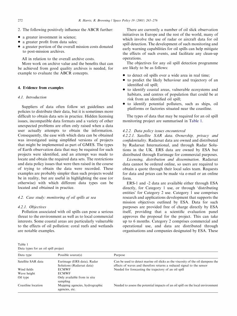
Table 1
Data types for an oil spill project
Data type Possible source(s) Purpo
Satellite SAR data Eurimage (ERS data), Radar
Solutions (Radarsat data)
Can b
effects
Wind fields ECMWF Neede
Wave height ECMWF
Oil type Only available from in situ
sampling
Coastline location Mapping agencies, hydrographic
agencies, etc.
Neede
There are currently a number of oil slick observationinitiatives in Europe and the rest of the world, many ofwhich involve the use of radar or aircraft data for oilspill detection. The development of such monitoring andearly warning capabilities for oil spills can help mitigatethe effects of such events, and facilitate any clean-upoperations.The objectives for any oil spill detection programme
are likely to be as follows:
* to detect oil spills over a wide area in real time;* to predict the likely behaviour and trajectory of anidentified oil spill;
* to identify coastal areas, vulnerable ecosystems andhabitats, and centres of population that could be atrisk from an identified oil spill;
* to identify potential polluters, such as ships, oilplatforms or factories situated near the coastline.
The types of data that may be required for an oil spillmonitoring project are summarised in Table 1.
4.2.2. Data policy issues encountered
4.2.2.1. Satellite SAR data. Ownership, privacy and
confidentiality. Radarsat data are owned and distributedby Radarsat International, and through Radar Solu-tions in the UK. ERS data are owned by ESA butdistributed through Eurimage for commercial purposes.
Licensing, distribution and dissemination. Radarsatdata cannot be ordered online, so users are required toobtain a quote through their local sales team. Requestsfor data and prices can be made via e-mail or an onlineform.ERS-1 and -2 data are available either through ESA
directly, for Category 1 use, or through ‘distributingentities’ for Category 2 use. Category 1 use comprisesresearch and applications development that supports themission objectives outlined by ESA. Data for suchpurposes are provided free of charge directly by ESAitself, providing that a scientific evaluation panelapproves the proposal for the project. This can takeup to 6 months. Category 2 comprises commercial andoperational use, and data are distributed throughorganisations and companies designated by ESA. These
se
e used to detect marine oil slicks as the viscosity of the oil dampens the
of waves and therefore returns a reduced signal to the sensor
d for forecasting the trajectory of an oil spill
d to assess the potential impacts of an oil spill on the local environment
ARTICLE IN PRESSR. Harris, R. Browning / Space Policy 19 (2003) 265–276 273
data cannot be downloaded or ordered online, but orderforms can be downloaded.
Pricing policy. While ERS data are free for researchpurposes, there are tight restrictions imposed on the useof such data. Additionally, acquiring data free of chargeis subject to panel review, which may mean that datacannot be acquired for several months after they arerequested.
4.2.2.2. Wind and wave data. Licensing, distribution and
dissemination. Wind and wave data are available fromECMWF, and can be obtained from the nationalmeteorological offices of member states. In the UK,ECMWF data can be obtained through the BritishAtmospheric Data Centre’s (BADC) website. Wind datacan be acquired through the BADC website, althoughaccess is restricted so that it is only used for bona fideresearch purposes, and must be applied for in advance.Near-real-time ECMWF data are restricted further, andaccess is granted on a case-by-case basis.QuikSCAT real-time ocean surface wind data can
also be obtained from the Internet free of charge viaanonymous FTP at the website http://podaac.jpl.nasa.-gov/quikscat/qscat data.html.
Standards and metadata. QuikSCAT data are onlyavailable in Hierarchical Data Format (HDF), whichmay be a problem if the user does not have the requiredsoftware.
Pricing policy. Data are free of charge for researchpurposes under WMO Resolution 40, subject toconditions. Marginal costs have to be paid for, however.QuikSCAT data are free and easily accessible todownload via an anonymous FTP.
4.2.2.3. Location of coastlines. Ownership, privacy and
confidentiality. Coastline location data are availablethrough data sets such as the World Vector Shorelineproduct produced by NOAA.
Standards and metadata. Accuracy is said to be suchthat 90% of all identifiable shorelines are located withina 250m radius circular error of their true geographicalpositions, based on WGS84.
Licensing, distribution and dissemination. World Vec-tor Shoreline data are not available to downloadbut are available on a CD-ROM that can be orderedfor US$75.
4.2.3. Conclusions on oil spill monitoring
Information is not always abundant and many datasets have conditions that constrain their extensive use.Many of the data sets also had conditions governingtheir use and acquisition, which could prove restrictivefor an oil spill-monitoring project. Radar data arerelatively simple to acquire; the main issue that maylimit access is cost. In addition, there is no on-lineordering or downloading system available for Radarsat
or ERS data. In an application such as oil spillmonitoring, which would require data in near-real time,a lack of immediately available data is a constraint.Additionally, the conditions by which ERS data can beobtained free of charge for research purposes are tightlycontrolled and fairly complicated. If research access isnot granted, the data have to be purchased which mightbe a limitation for some applications. Additionalsupporting information, such as that used to forecast aspill trajectory, comes from a variety of sources, and itsaccessibility is variable. Ocean surface wind data fromthe QuikSCAT satellite is freely available for anyone todownload via FTP. By comparison, wind data derivedfrom ECMWF data are free, but access is restricted sothat it can only be used for bona fide research, and itsuse can be monitored.The accuracy and scale of some spatial data sets may
be unsuitable for applications such as oil spill monitor-ing. The mapping and topography data that may beneeded for oil spill monitoring were relatively easy toacquire through NOAA. World Vector Shoreline datawere easily obtainable on CD through the NOAAwebsite, for a reasonably low cost of US$75. Accuracyand scale are likely to be the main issues limiting thesedata for oil spill monitoring. World Vector Shorelinedata are said to be accurate to within a 250m radius oftheir true location, and suitable for scales of close to1:250 000. For oil spill monitoring on a more local level,this may not meet the required accuracy.Some data sets are already available for access and
view free of charge, are accompanied by descriptivemetadata and were easy to locate. The NASA QuikS-CAT data were available free of charge and easilydownloaded from the NASA Jet Propulsion Laboratorywebsite (via FTP). In addition, the data were describedin detail and the user can browse all GIF images of thedata before downloading. There are few restrictions onthe use of the data.
4.3. Case study: earthquake monitoring
4.3.1. Objectives
Earthquakes can be a particularly devastating naturalphenomenon, and often result in severe social andeconomic consequences. Use of the Earth observationdata to aid earthquake monitoring programmes couldtherefore be a valuable tool in mitigating the effects ofsuch events.The main objectives of an earthquake-monitoring
programme might be as follows:
* monitoring seismic activity and crustal deformation;* identification of areas most at risk from the effects ofearthquakes;
* provision of information and support for emergencyservices/government after a disaster occurs.
ARTICLE IN PRESS
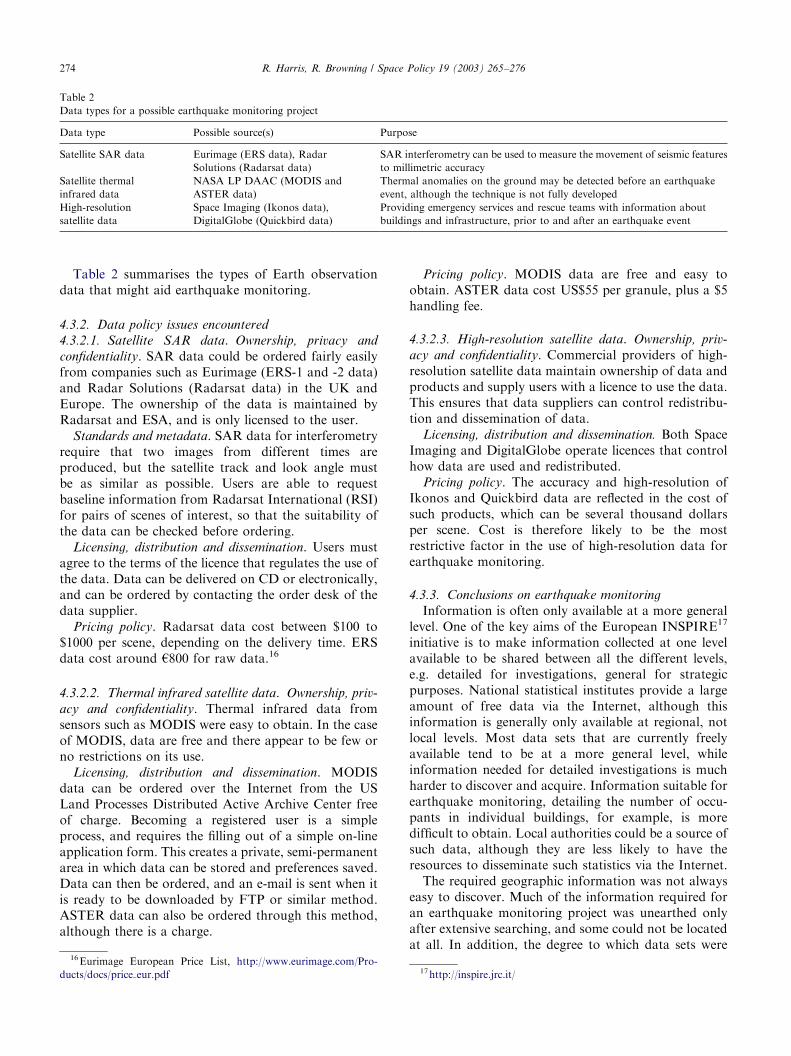
Table 2
Data types for a possible earthquake monitoring project
Data type Possible source(s) Purpose
Satellite SAR data Eurimage (ERS data), Radar
Solutions (Radarsat data)
SAR interferometry can be used to measure the movement of seismic features
to millimetric accuracy
Satellite thermal
infrared data
NASA LP DAAC (MODIS and
ASTER data)
Thermal anomalies on the ground may be detected before an earthquake
event, although the technique is not fully developed
High-resolution
satellite data
Space Imaging (Ikonos data),
DigitalGlobe (Quickbird data)
Providing emergency services and rescue teams with information about
buildings and infrastructure, prior to and after an earthquake event
R. Harris, R. Browning / Space Policy 19 (2003) 265–276274
Table 2 summarises the types of Earth observationdata that might aid earthquake monitoring.
4.3.2. Data policy issues encountered
4.3.2.1. Satellite SAR data. Ownership, privacy and
confidentiality. SAR data could be ordered fairly easilyfrom companies such as Eurimage (ERS-1 and -2 data)and Radar Solutions (Radarsat data) in the UK andEurope. The ownership of the data is maintained byRadarsat and ESA, and is only licensed to the user.
Standards and metadata. SAR data for interferometryrequire that two images from different times areproduced, but the satellite track and look angle mustbe as similar as possible. Users are able to requestbaseline information from Radarsat International (RSI)for pairs of scenes of interest, so that the suitability ofthe data can be checked before ordering.
Licensing, distribution and dissemination. Users mustagree to the terms of the licence that regulates the use ofthe data. Data can be delivered on CD or electronically,and can be ordered by contacting the order desk of thedata supplier.
Pricing policy. Radarsat data cost between $100 to$1000 per scene, depending on the delivery time. ERSdata cost around h800 for raw data.16
4.3.2.2. Thermal infrared satellite data. Ownership, priv-
acy and confidentiality. Thermal infrared data fromsensors such as MODIS were easy to obtain. In the caseof MODIS, data are free and there appear to be few orno restrictions on its use.
Licensing, distribution and dissemination. MODISdata can be ordered over the Internet from the USLand Processes Distributed Active Archive Center freeof charge. Becoming a registered user is a simpleprocess, and requires the filling out of a simple on-lineapplication form. This creates a private, semi-permanentarea in which data can be stored and preferences saved.Data can then be ordered, and an e-mail is sent when itis ready to be downloaded by FTP or similar method.ASTER data can also be ordered through this method,although there is a charge.
16Eurimage European Price List, http://www.eurimage.com/Pro-
ducts/docs/price eur.pdf
Pricing policy. MODIS data are free and easy toobtain. ASTER data cost US$55 per granule, plus a $5handling fee.
4.3.2.3. High-resolution satellite data. Ownership, priv-
acy and confidentiality. Commercial providers of high-resolution satellite data maintain ownership of data andproducts and supply users with a licence to use the data.This ensures that data suppliers can control redistribu-tion and dissemination of data.
Licensing, distribution and dissemination. Both SpaceImaging and DigitalGlobe operate licences that controlhow data are used and redistributed.
Pricing policy. The accuracy and high-resolution ofIkonos and Quickbird data are reflected in the cost ofsuch products, which can be several thousand dollarsper scene. Cost is therefore likely to be the mostrestrictive factor in the use of high-resolution data forearthquake monitoring.
4.3.3. Conclusions on earthquake monitoring
Information is often only available at a more generallevel. One of the key aims of the European INSPIRE17
initiative is to make information collected at one levelavailable to be shared between all the different levels,e.g. detailed for investigations, general for strategicpurposes. National statistical institutes provide a largeamount of free data via the Internet, although thisinformation is generally only available at regional, notlocal levels. Most data sets that are currently freelyavailable tend to be at a more general level, whileinformation needed for detailed investigations is muchharder to discover and acquire. Information suitable forearthquake monitoring, detailing the number of occu-pants in individual buildings, for example, is moredifficult to obtain. Local authorities could be a source ofsuch data, although they are less likely to have theresources to disseminate such statistics via the Internet.The required geographic information was not always
easy to discover. Much of the information required foran earthquake monitoring project was unearthed onlyafter extensive searching, and some could not be locatedat all. In addition, the degree to which data sets were
17http://inspire.jrc.it/
ARTICLE IN PRESSR. Harris, R. Browning / Space Policy 19 (2003) 265–276 275
discovered and available was often dependent on thecountry or region to which the data referred. Forexample, US data and information are often easy todiscover and are made available online. Geological datafor European countries are not available from a centralsource, but are often accessed through the mappingagencies of individual countries. Data policy andaccessibility of data are therefore dependent on thepolicies of the country and organisation involved.The price of the Earth Observation data is variable and
can be prohibitively expensive. Earth observation data areeasy to find and obtain via the Internet, although theiraccessibility and cost are variable. Some data provided byNASA (e.g. MODIS) are free of charge and can bedownloaded directly from NASA servers. Radarsat andERS data have much more restricted access, and have tobe paid for if they are to be used for commercial purposes.Ikonos and Quickbird data also have restrictive licensingpolicies regarding the use of their high-resolution data,which are expensive to purchase.
5. Conclusions
5.1. Main issues
Legal obligations are important in driving dataaccessibility. Examples of legal obligations include theprovision of national statistics to Eurostat, the Germanlaw on environmental information (Umweltinforma-
tionsgesetz), which states that all data concerning natureand the environment in German public authorities mustbe freely available and free of charge, and the ECDirective on Freedom of Access to EnvironmentalInformation. In the case of Earth observation, legalobligations are often defined under international agree-ments such as the UN Remote Sensing Principles, whichhave not reached treaty status but are consideredcustomary international law. The UN Remote SensingPrinciples support the idea of Earth observation systemsas public goods, in both economic and ideological terms.The concept of public good is common in many
organisations that provide environmental data of valueto GMES. It is typical for there to be few restrictions ondissemination of data if the application or use of theinformation is for the public good, while there is acontrol of the data if provided for commercial applica-tions. Geospatial data display some of the character-istics of a public good [5]. A public good has two maincharacteristics [6]: non-rivalry and non-excludibility.Non-rivalry means that the use of the information doesnot diminish the capability of another user to use it.Non-excludibility means that no one user can be ex-cluded from using the information by another user [7].In many areas of GMES, there is a strong public goodcase, although it is essential that this case is considered
in parallel with the need to ensure a sustainable basefor GMES.
Approaches to pricing are important signals to themarket for environmental information. A commonmodel used by environmental information and Earthobservation data providers is to set a market price, thatis the price that the market will bear (which may be zeroin some applications). For activities that contribute tothe public good, like scientific research, environmentaldata are often free or made available at the cost ofreproduction. One challenge here lies in the transitionfrom research to operational systems. Mature opera-tional systems that use Earth observation data (e.g. inmeteorology) can readily justify the costs. Projects thatshow operational potential often find it more difficult tojustify the costs of such data because the benefits are noteasy to quantify or to capture by prediction alone.The Internet is changing pricing and distribution policy.
There is a shift from providing data at the cost ofreproduction to providing data free of charge. Thisreflects the logic of the short-run marginal cost. When itis necessary to produce (say) a CD to hold a data set,there is a cost of materials, labour and posting. Whenthe data set is made available on a server there is no costto the data provider in delivering the data, so the cost ofreproduction falls to zero. This has implications for thedissemination of data in GMES.
Standards and metadata continue to present problemsin that many different systems are used and convergenceis limited. The best practice is in meteorology which ischaracterised by being operational and international,features that will ultimately characterise GMES. Anopen question here though is how far GMES will be ableto stimulate community consensus on streamlinedstandards and metadata. The work of the InternationalOrganization for Standardization (ISO) is increasinglyimportant and relevant to GMES, for example ISO19115 on environmental data.
Archives of the Earth observation data are usually indigital form, but other data archives relevant to GMESare in hard copy form. Digital data archives havepresented physical problems in media and readingmachines, particularly where data have been collectedover long periods of time. In such cases, the originalstorage media in which data are stored at the beginningof a mission are often superseded as technologyimproves, requiring costly and time consuming retrans-fer of data to the new storage medium. This is likely tobe an ongoing problem as progress in digital storage andcomputer technology continues to develop.
Acknowledgements
This paper reports work carried out as part of aEuropean Commission project entitled ‘Data Policy
ARTICLE IN PRESSR. Harris, R. Browning / Space Policy 19 (2003) 265–276276
Assessment for GMES’. We are grateful to the followingfor discussions on data policy and GMES: MichelCornaert, Alan Edwards, Barry Wyatt, Peter Ryder,David Briggs and Nina Costa.
References
[1] European Commission. Key elements of the GMES EC Draft
Action Plan. Initial Period, Brussels, 2001–2003, 27 July 2001.
[2] Johnston S, Cordes J. Public good or commercial opportunity?
Case studies in remote sensing commercialisation. Space Policy
2003;19:23–31.
[3] Harris R, editor. Earth observation data policy and Europe. The
Netherlands: Balkema; 2002. 211pp.
[4] Schreier G. Data policy implications on archive design—or vice
versa? In: Harris R, editor. Earth observation data policy and
Europe. The Netherlands: Balkema; 2002. p. 169–80.
[5] Ordnance Survey, Economic Aspects of the Collection, Dissemina-
tion and Integration of Government’s Geospatial Information. A
report arising from work carried out for Ordnance Survey by
Coopers & Lybrand. Southampton: Ordnance Survey; 1996.
70pp.
[6] Pearce D. Capturing environmental value, Blueprint 4. London:
Earthscan Publications Ltd; 1995. 212pp.
[7] Harris R. Earth observation data policy. Chichester: Wiley; 1997.
155pp.