Embed Size (px)
Citation preview
Transportation Research Record 757
Glenwood Canyon Interstate 70: A Preliminary Design Process That Worked
RICHARD A. PROSENCE AND JOHN L. HALEY
After nearly 20 years of study and 10 years of controversy and debate about the construction of an Interstate highway through picturesque Glenwood Canyon, the Colorado Department of Highways has developed and implemented a unique design development process that has won widespread public support for the project. The way seems to now be clear for closing one of the last gaps in the Colorado Interstate system. The open planning and design process allowed maximum public participation not only in the identification and preservation of critical environmental and recreational factors but also in the selection of technical design concepts for the highway. The design development process demonstrated how a politically and publicly controversial project received endorsement from virtually all elements of the public. The process is unique in that it used sports enthusiasts, naturalists, artists, and many lay persons to evaluate and decide on highly technical design issues and asked scientists, engineers, architects, and construction contractors to identify and demonstrate environmental, recreational, social, and aesthetic impacts. Modern design tools, including computer graphics, electronic survey instruments, and photo montages, were mixed with artists' drawings, sketches, models, and field mock·ups to suggest final alignments and grades, locate structures, pinpoint roadside facilities, and resolve safety issues. Completion of the design development process has culmi· nated in the holding of a design public hearing, issuance of a design report that has been accepted by the vast majority of interested agencies and individuals, and design approval by the Federal Highway Administration. Use of the methodology developed in this process will provide an alternative to delays, repetitious studies, public and political controversy, increased costs, and litigation.
The purpose of this paper is to describe a unique design development process that culminated in a favorable consensus on a controversial Interstate highway project in western Colorado. Design elements were a key issue in discussions about the Glenwood Canyon segment of Interstate 70 (I-70). The usual post-environmental impact statement (EIS) approval process would be to hold a formal design public hearing and proceed with design development. However, in the case of Glenwood Canyon, many people thought that a poorly designed freeway would impose unacceptable impacts on this scenic wonder.
So cardinal was this concern that the Federal-Aid Highway Act of 1976 allowed variations from Interstate standards for this segment of I-70. Without the implementation of an open process to provide much opportunity for participation by the public, the prospects of advancing this project to construction appeared bleak in 1976, when route location approval was granted.
GLENWOOD CANYON
Glenwood Canyon, located in west-central Colorado about 240 km (150 miles) west of Denver, is the result of a gradual uplift of the Rocky Mountains over the past 30-40 million years. The Colorado River has downcut through younger metamorphic rocks into the pre-Cambrian formation to expose steep and majestic canyon walls that rise up to 915 m (3000 ft) above the river. The nearly vertical rock faces are accented and complemented by steep talus slopes, covered with multicolored vegetation. The grandeur and unblemished beauty of the upper reaches of the canyon make this transportation corridor one of the nation's most spectacular traveling experiences.
The floor of the canyon reflects its natural and man-made history as a transportation corridor. On one side of the Colorado River, US-6, a two-lane, low-capacity, and unsafe highway that carries up to 11 000 vehicles/day runs parallel to the river. On the opposite shore is the single-track, 24 trains/day, Denver and Rio Grande Western Railroad that is scheduled for expansion to two tracks to accommodate the ever-increasing coal train traffic.
Shoshone Dam, located midway through the canyon, backs up the Colorado River into a 6.4-km (4-mile) long reflective pool that adds tranquility to the canyon's beauty but restricts the available space for further construction considerably. From Shoshone Dam a 3.2-km (2-mile) long tunnel carries part of the river through the north canyon wall t\) a hydroelectric generating plant owned by Public Service Company of Colorado. From the power plant, transmission lines follow the canyon both east and west and transport much needed energy out of the area.
Limited vegetation and sheerness of the canyon walls restrict its use by wildlife, although numerous mule, deer, and other animals and birds use the canyon for grazing, hunting, and nesting.
Recreation uses are heavy and increasing. Rafters, kayakers, fishermen, and picnickers use the river. Hikers, bicyclists, and campers compete for the limited space along with recreation vehicles, rock climbers, photographers, and other tourists.
The importance of Glenwood Canyon as an Interstate highway corridor is readily matched by its many important natural, social, recreational, environmental, and economic benefits. The unique characteristics of the canyon made it appropriate for the Colorado Department of Highways to develop and implement a special process for planning the design and construction of 1-70 through this spectacular canyon.
PROJECT BACKGROUND
The project began more than 20 years ago when Congress authorized the extension of 1-70 west from Denver to 1-15 in Utah. Although Glenwood Canyon was incorporated along the initial corridor for the highway, the obvious engineering and environmental problems encountered along this narrow, twisting 21-km (13-mile) route caused the Colorado Department of Highways to undertake a detailed investigation of potential alternative routes.
Beginning during 1970, alternative locations, including north and south bypasses of the canyon, were studied in detail. The Colorado Department of Highways initiated and completed a comparative evaluation of the social, economic, and environmental impacts of highway construction along each of these alignments. After release of the draft EIS, a corridor public hearing was held. The final EIS, issued in 1972, recommended that Glenwood Canyon tie the location of I-70 and that the other alignments be eliminated from further consideration.
Although the Glenwood Canyon corridor was firmly established as the most logical location for I-70, much concern remained as to whether a highway could be designed that would meet both Interstate standards and the mandates of the Colorado legislature, which had passed a resolution that stated, "The interests of the people of this state will be best served by a highway so designed that .•. the wonder of human engineering will be tastefully blended with the wonders of nature."
To help find the most acceptable solution, the Colorado Department of Highways retained three nationally recognized consulting firms for a design comparison. This was an unusual departure for highway design even though it is a well-established technique for important architectural projects. The resulting concepts developed in the comparison were as follows:
2
1. A double-decked structure with truck traffic restricted to the lower level,
2. An Autostrada-type highway partly located high up on the canyon walls to leave portions of the canyon floor free of highway traffic, and
3. A more conventional design confined to the platform along the canyon floor.
Although none of the design concepts was accepted in total, the comparison illustrated that careful design techniques could enable an Interstate highway to be constructed without severe permanent impacts on the visual and recreational elements of the canyon.
In 1976 the U.S. Department of Transportation (DOT) officially designated Glenwood Canyon as the I-70 corridor. In the same year Congress passed the Federal-Aid Highway Act with an amendment that stated as follows (PL 94-280, Section 152):
The Secretary of Transportation is authorized upon application of the Governor of the state, to approve construction of that section or portions thereof of Interstate Route 70 from a point 3 miles (4.8 km] east of Dotsero, Colorado, westerly to No Name Interchange, approximately 2.3 miles (3. 7 km] east of Glenwood Springs, Colorado, approximately 17 .5 miles (28.2 km] in length, to provide for variations from the number of lanes and other requirements of said Section i09(b) in accordance with geometric and construction standards whether or not in conformance with said Section 109(b) which the Secretary determines are necessary for the protection of the environment, and for preservation of the scenic and historic values of the Glenwood Canyon. The Secretary shall not approve any project for construction under this section unless he shall first have determined that such variations will not result in creation of safety hazards and that there is no reasonable alternative to such project.
During the spring of 1976, the Colorado Department of Highways officially initiated an open planning and design process and specified in a published work program the techniques and procedures to be followed in carrying out the project. Four groups of participants were identified to be involved in conceptual studies with the department. The groups consisted of a citizens advisory committee (CAC), whose seven members were designated by the highway commission to work directly with the department of highways staff; two citizen workshop groups, which consisted of residents of the study area working separately and independently of each other; and a technical review group (TRG), which consisted of federal and state agencies, two private companies, and professional organizations that have a direct interest in I-70.
Project objectives adopted to be implemented in the design and consti·uction programs were as follows:
1. The highway must be Slife and provitle Ii ret:1.so11able level of service;
2. The highway must not destroy or preclude important recreation potentials related to the canyon;
3. The visual quality of the highway should not detract from the landscape and should be of high design quality;
4. The highway should affora a pleasant driving experience;
5. The construction procedures must be carefully planned and continuously monitored to avoid undue environmental damage; and
6. Environmental protection measures, revegetation programs, and landscaping plans must be fully implemented.
From the start, an extraordinary effort was made to get people involved. Bus tours were conducted through the canyon by Colorado Department of Highways representatives, who described conflicts and challenges. An information office was kept open at night with a telephone
Transportation Research Record 757
line so that people could call in and have questions answered. Canyon Echos, a newsletter, was printed and distributed periodically. A community attitude survey was completed by a professional survey firm. Workshop participants were assisted by professionals and furnished with numerous graphic materials during their deliberations.
During December 1976, the CAC made its first report to the state highway commission. The report recommended that a narrow, four-lane highway be constructed in the canyon. It also recommended that, for comparison purposes only, a two-lane design be developed for critical areas of the canyon.
In February 197 7, the preliminary design process was begun. Later that year the CAC filed its final report with the state highway commission. They had reached a Consensus that a four-lane facility was generally acceptable.
Following· the holding of a design public hearing in March 1978, work began on the formal design report, which was transmitted to the Federal Highway Administration (FHWA) during March UJ79. On September 17, 1979, FHWA informed the Colorado Department of Highways that the design was approved and final design was authorized.
Conceptual Design Conclus ions
The special consideration given Glenwood Canyon by Congress found in the Federal-Aid Highway Act of 1976 coupled with the mandate from the Colorado legislature and the extensive planning process carried out by the Colorado Department of Highways established two basic issues as being of equal importance and complexity:
1. Safety and capacity and 2. Recreational, environmental, and visual impacts.
In setting the preliminary Colorado Highway Commission accepted the theme and thrust set the conceptual planning process.
Preliminarv Design Parameters
design objectives, the wisely and prudently
by CAC and TRG during
Based on the conclusions of the conceptual planning process, a number of formal and informal design objectives were accepted and implemented for the preliminary design phase of the project. Certain of these were very precise and technically defined; others were deliberately left flexible and general in definition to allow maximum public participation, uninhibited discussion, innovative design approaches, and thorough understanding and acceptance by all participants.
The number, definition, and priority of the design objectives were never precisely documented or spelled out because it was unders tood and accepted that each participant brought to the process a specific set of goals.
Among the numerous individual design objectives were the following generally accepted goals that guided the daily activities and specific ali(jnment, !jrade, and structural decisions:
1. Interstate standards for 80-km/h (50-mph) design speed;
2. Four-lane divided, separated, or barrier-protected cross section;
3. No relaxation of minimum safety standards; 4. Minimal intrusion of the highway on the existing
features and vistas of the canyon; 5. Maximum adaptation of the design to the natural
characteristics of the rocks, vegetation, waterway, wildlife, recreation, and appearance of the canyon;
6 Design to repair , expand, enhance, and improve the benefits to travelers, recreation users, property owners, and the existing facilities whenever practica~
7. Design process to encourage maximum participation and understanding by all agencies, businesses, special interest groups, and individuals;
Transportation Research Record 757
8. Design process to provide maximum exposure and disclosure of all pertinent facts and considerations during· the procedures;
9. Presentation at the design public hearing of all identified benefits and adverse impacts and an easily understood display of precise alignment, grade, structures, schedules, costs, and economic factors; and
1 U. Publication of a design report that would fully describe and document the design process, alternative designs, the selected design itself, the effects of the project, the public hearing comments and responses, and all other information required to obtain the approval of the Colorado Highway Com mission, FHW A, and the Secretary of Transportation.
DESIGN DEVELOPMENT PROCESS
Object ives
The basic objective of the design development process was to refine conceptual designs to a point of having sufficient detail to allow the holding of the design public hearing. The intent was not to have all design decisions finalized at the time of the hearing. However, it was intended that all recommended solutions would be sufficiently developed to present a complete and factual statement to the public of major details, costs, and impacts, and to be prepared to answer all pertinent questions. A secondary objective was to enable the orderly and logical scheduling and accomplishment of all subsequent final desig·n and construction activities.
This was to be accomplished in accord with the conclusions of the conceptual planning phase in an open, well-publicized process that invited public participation and kept all interested parties fully informed at all times.
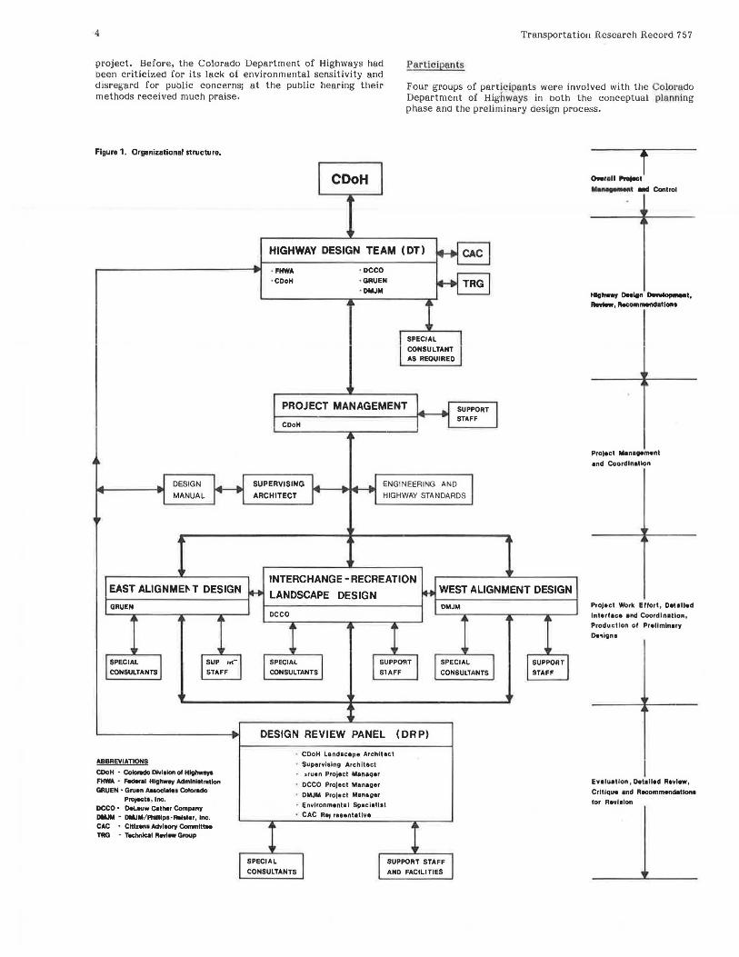
~tructure
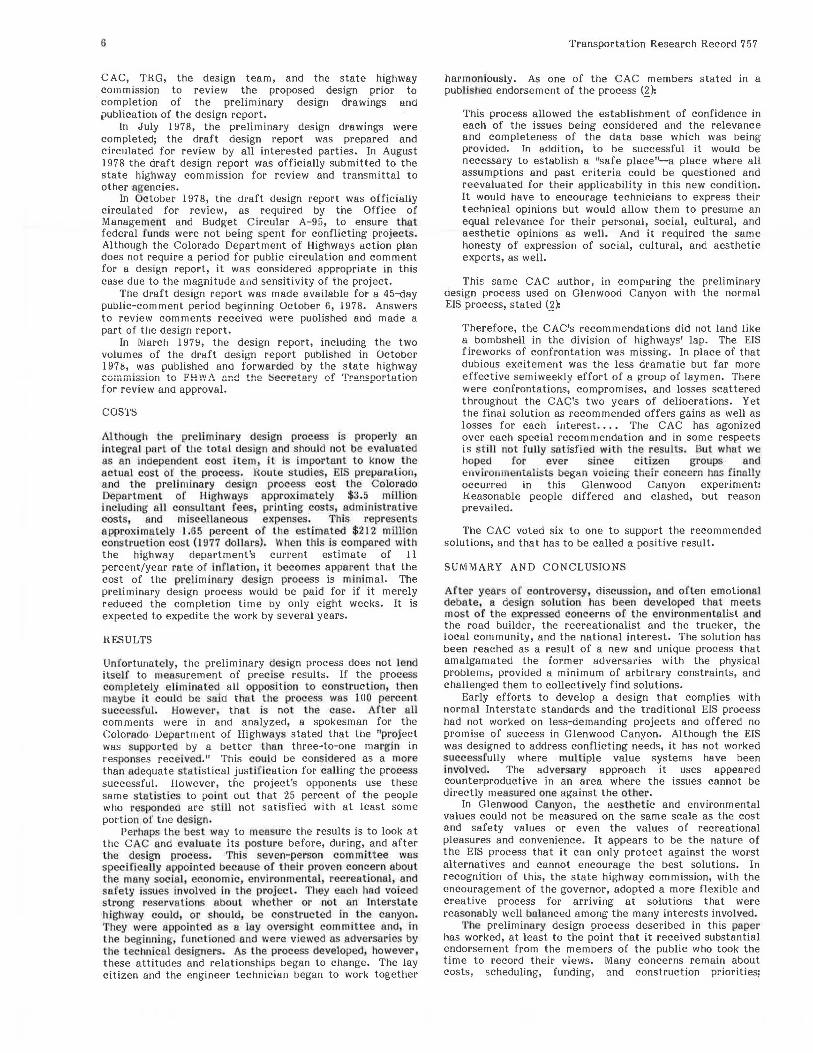
The chart in Figure l shows the management format and relationships between the various elements of the design team, CAC, TRG, the consultants' staffs, and the design review panel (DRP).
Each step in the design process was followed by a presentation for review and concurrence to the CAC, TRG, and the Colorado Department of Highways prior to completion and development of the next step. Only after a thorough screening and review by the entire design team and DRP was an alternative allowed to progress to the next step.
The Process
The basic process was for the design consultants to develop options and alternatives in sufficient detail to enable them to discuss each with members of the desig·n team (and frequently representatives of CAC and TRG). Critical comments and sugg·ested modifications would be made by the desig·n team and O.RP along· with requests for additional information or verification of data. Frequently, new concepts or approaches would be developed in the field and the process would begin again for further refinement or the start of a new cycle.
Each consultant project manager was responsible for the development, presentation, and defense of the alternatives developea by staff in his or her particular area and, as a member of the D.RP, was also responsible for review, evaluation, and constructive criticism of other areas. This dual role as designer-critic demanded the utmost in cooperation and coordination.
Each design consultant was responsible for the development and presentation of support materials to demonstrate the visual, environmental, and technical benefits of his or her design alternative. In addition to the usual plan-profile sheets, typical cross sections and computer printouts, artists sketches, photo montages, scale models, and field staking were used to demonstrate a particular alternative. When even these proved inadequate,
3
the designers constructed full-scale models and cloth curtains in the canyon cut to actual structural dimensions, along the canyon walls and across the river to simulate proposed alignment, elevations, and grades. Designated tunnel portals were outlined on the rock faces, limits of construction were flagged, and individual trees scheduled for removal were marked in the field.
These visual aids were used by both the designers and the reviewers to develop and test alternatives, identify conflicts, pinpoint environmental losses, illustrate the visual impacts, and establish the future driving and viewing experience for both the motorists and the pedestrian users of the canyon. These were not marketing displays designed to convince the public of the values of a particular solution; these were design tools used by the designers to forecast and prove (or disprove) specific design alternatives.
By January 1978, the design team, TRG, and CAC had generally agreed on an optimum design to be taken into the final design process for much of the canyon. It was a hybrid solution that used a variety of concepts carefully fitted to the diverse character of the canyon. As a result of the various design, display, and informational techniques, and the very active participation of all the CAC and TRG members, a consensus was reached and a design public hearing was scheduled for March 1978. Alternative designs would be presented to the public for five specific locations as well as the recommended design for the remainder of the canyon.
Public Hearing
A prehearing display at a local hotel was opened to the public 10 days prior to the public hearing. The display was well attended and attracted 840 registered visitors. A team member was on hand to explain the exhibits and answer any questions. The positive response at the public hearing was attributed, in part, to the prehearing display and the candor of the responses to questions asked. The prehearing display educated the public concerning the project. All inquiries concerning the design process, reasons for the selection of various alternatives, and the factual results of the recommended solution, were responded to in detail.
Special exhibits were prepared for the public hearing held at Glenwood High School on March 21, 1978. These exhibits included five scale models and thirty-one 4 x 8-ft panels that clearly illustrated the recommended solutions and the unresolved alternatives. Special care was taken to explain the design process, design guidelines, selected alignments, recreation and landscape provisions, estimated costs, and the anticipated schedule of events to follow.
CAC publicly recommended endorsement of the designs and the process and documented their consensus where alternatives were still under consideration. In their report the CAC applauded the design process and stated (l):
The decision that was made to involve, educate, and bring along a lay oversight committee like the CAC was a daring and courageous one. It admits the shortcomings of traditional hearing and impact statement processes which cater to confrontation instead of conciliation and compromise. It places a great deal of trust in a social process that must be in conflict with the traditionally developed technical skills within the highway fraternity. And it exposed all the decision-making steps to a public press that is frequently more interested in highlighting the conflicts than in the resolution of tough issues.
More than 300 persons attended the public hearing. Of these, 35 gave direct testimony and an additional 81 provided letters either in support of or objection to various recommended solutions. At the public hearing there were many statements made to compliment, commend, and support the preliminary design process and its extensive public involvement. No speaker voiced opposition to or criticism of the process. This is particularly significant in lig'ht of the highly controversial and emotional history of the
4 Transportation Research Record 757
project. Before, the Colorado Department of Highways had been criticized for its lack of' environmental sensitivity and disregard for public concerns; at the public hearing their methods received much praise.
Partic ipants
Four groups of participants were involved with the Colotado Department of Highways in Doth the conceptual planning phase ano the preliminary design process.
Figure 1. Organizational structure.
DESIGN
MANUAL
EAST ALIGNMEI' T DESIGN
GRUEN
SPECIAL
CONSULTANTS
ABBREVIATIONS
SUP ,,.
STAFF
CDoH • ~ Dlvlolon ol H~ FHWA - -•I Hlgllwey Admlnll1111tlon GRUEN • Gruen Auoclateo Colcndo
Project I, Inc. DCCO • Del.euw Cather Compony DMJM - DMJM/Phllllp• · llolater, Inc. CAC - CHlzena AdvltMY Committee TAO • Technical Revl- Group
CDoH
HIGHWAY DESIGN TEAM (OT)
· FHWA • CDoH
· DCCO
• GRUEN
· DMJM
SPECIAL
CONSULTANT
AS REQUIRED
PROJECT MANAGEMENT SUPPORT STAFF
CDoH
SUPERVISING
ARCHITECT
ENGINEERING AND
HIGHWAY STANDARDS
INTERCHANGE - RECREATION
LANDSCAPE DESIGN WEST ALIGNMENT DESIGN
DCCO
SPECIAL
CONSULTANTS
SUPPORT
SlAFF
DESIGN REVIEW PANEL (DR P)
• CDoH Landacape Architect
· Supervising Architect
~ruen Project Manaqer
• DCCO Project Manager
• DMJM Project Manager
• Environmental Speciallst
• CAC R•J re1entatlve
DMJM
SPECIAL
CONSULTANTS
SPECIAL
CONSULTANTS
SUPPORT STAFF
AND FACILITIES
SUPPORT
STAFF
T °"91• 11 ........ t
....._.,., - Control
Hlehw•Y 0..lgn DeN..,_t,
--· RecommendallOM
Project M•negement
•nd Coordination
Project Work Ellort, Detalled
lnterf•c• •nd Coordln1tlon, Production of Prellmln.,y
De-.iQn1
Evafu1Uon 1 O.t1lled Review ,
Critique and Recommendation•
for Aevi1lon
Transportation Research Record 7 57
CAC
A CAC, which consisted of seven members nominated by various governmental and public agencies, was appointed by the state highway commission. The CAC was drawn in the following manner: one representative each from the four adjacent counties (as nominated by their respective county commissioners), one member from Club 20 (a west-slope organization of 20 counties), one member from the Colorado Open Space Council, and one member from the American Institute of Architects. The CAC was directed to work directly with the staff of the highway department and its consultants and report directly to the state highway commission their conclusions, recommendations, and concerns regarding alternative social, environmental, and economic impacts of various proposals, to suggest changes, and to critically review all suggestions and design alternatives proposed by others.
Citizen Workshops
To assist the CAC and to broaden the base of citizen input, 37 local citizens were appointed to two workshops that met separately and independently each week to study issues and produce reports to the CAC that expressed their concerns and recommendations. The Wednesday night workshop and the Thursday night workshop committees held many meetings, involved hundreds of hours of volunteer effort, and produced numerous reports, suggestions, and constructive criticisms. Their membership consisted of business persons, homemakers, sports enthusiasts, ranchers, males and females, young and elderly, and teachers and students. The CAC was structured to be truly representative of all the people concerned with the development of I-70 in Glenwood Canyon.
TRG
A TRG, which consisted of representatives from the following organizations was created to study, evaluate, make technical decisions, and advise on technical impacts of all design alternatives: U.S. Forest Service; U.S. Bureau of Land Management; U.S. Bureau of Outdoor Recreation; Colorado Division of Wildlife; Public Service Company of Colorado; Denver and Rio Grande Western Railroad; Architects, Planners, Engineers, Surveyors (a local professional society); U.S. Environmental Protection Agency; Colorado Contractors Association; U.S. Geological Survey; and Colorado Department of Health. Each of these agencies had a direct interest in the development of I-70 and the future of Glenwood Canyon. Their representatives, either as members of the committee or as individuals, spent varying amounts of time reviewing proposals and advising on their area of expertise or special interest.
Consultants
During the preliminary design process, additional participants were involved either as consultants or as individual participants on special panels or teams. Assisted by the CAC, the Colorado Department of Highways interviewed several nationally recognized design consultants to survey, inventory, design, and develop detailed alternative solutions for the entire project. The firms of DMJM/Phillips, Reister, Inc., of Denver, and Gruen Associates of Los Angeles, were chosen as design consultants to work with DeLeuw Cather and Company, the supervising architect, and all the other participants during the preliminary design process.
Highway Design Team
From the above group·s and the staffs of the Colorado Department of Highways and FHWA, Colorado division, a highway design team was created. The team included designers and engineers from each of the major consultants
5
and was supported by the staff and resources of each organization. In addition, the design team selected and employed special consultants, as needed, to assist the design process in general.
This design team worked together, but each designer was primarily responsible for an assigned segment of the project. The design team developed technical answers and detailed plans for each alternative.
DRP
To review and critique the work of the design team, a DRP was created. It consisted of a representative of the CAC, one member of the TRG, the project manager from each of the major consultants, and representatives from the Colorado Department of Highways and FHW A.
CHRONOLOGY AND EFFORT
In January 1977, the state highway commission approved proceeding with the preliminary design of a four-lane roadway through the canyon. CAC and TRG were asked to continue their involvement in the process and funds were allocated to support the necessary consulting services.
In February 1977, the Colorado Department of Highways published a detailed work program for the preliminary design phase. This specified basic design standards, organizational responsibility and relationships, an outline of key tasks to be performed by consulting designers, and processes to be followed in the design, screening, review, and acceptance of solutions.
In March 1977, the consulting roadway designers were brought on board to work with the highway department, FH WA, CAC, TRG, and the supervisfog architect to carry out the work program. In May 1977, approved planning and design guidelines and the Architectural and Planning Design Handbook were distributed to the design team, CAC, and TRG, and the actual field work commenced.
From May 1977 to February 1978, the design team, DRP, CAC, and TRG held regularly scheduled weekly, biweekly, and monthly meetings. During this time approximately 20 formal meetings were held that involved CAC and TRG. Several walking field trips to the canyon were made to view site-specific problem areas, review design alternatives, and inspect full-scale models, mock-ups, or field conditions pertinent to a design.
Several special meetings were held to brief the state highway commission, Colorado's governor, the press, and the public on the progress of the designs. All meetings were well adverti'sed in advance and specific invitations were made to the press and individuals or groups that held a special interest in a particular design or problem area.
Each month 1000 copies of Canyon Echos, a special news bulletin, were distributed to a mailing list of 400, and the remainder were distributed free through stores and shops in the area. Each issue of Canyon Echos gave an up-to-date progress report and showed examples of studies and techniques being used to find optimum solutions.
In February 1978, the design team met to determine which alternatives were to be recommended to the public in the design public hearing. Decisions were made on which alternatives were to be presented and how the information should be displayed and explained.
In March 1978, the prehearing display was set up, and staff was on hand for 10 days prior to the actual public hearing. Special care was taken to advertise the project, including a special issue of Canyon Echos, which was included as a supplement in a local paper. The design public hearing was held on March 20, 1978.
In April UJ78, the design team and DRP met to review the record of the public hearing and the comments received and to decide on proposed design solutions to be presented in the design report.
Several meetings were held in !Viay, June, and July 1978 between the Colorado Department of Highways, FHWA,
6
CAC, TH.G, the design team, and the state highway commission to review the proposed design prior to completion of the preliminary design drawings and publication of the design report.
In July l !J78, the preliminary design drawings were completed; the draft design report was prepared and circulated for review by all interested parties. In August 1978 the draft design report was officially submitted to the state highway commission for review and transmittal to other agencies.
In October 197 8, the draft design report was officially circulated for review, as required by the Office of Management and Budget Circular A-95, to ensure that federal funds were not being spent for conflicting projects. Although the Colorado Department of Highways action plan does not require a period for public circulation and comment for a desig·n report, it was considered appropriate in this case due to the magnitude and sensitivity of the project.
The draft design report was made available for a 45-<lay public-comment period beginning October 6, 1978. Answers to review comments received were published and made a part of tile design report.
In March l 97!J, the design report, including the two volumes of the draft design report published in October 1978, was published and forwarded by the state hig·hway co:nmission tc FH VV /\,.. und the Secretary of Transportation for review and approval.
COSTS
Although the preliminary design process is properly an integral !)art of tile total design and should not be evaluated a.s an independent cost Item, it is important to know the actual cost of the process. Route studies, EIS prepuruliol'I, and the preliminary design pl'ocess cost the Colorado Department of Highways approximately $3.:> million including all consultant fees, printing costs, administrative costs, and miscellaneous expenses. This represents approximately 1.65 percent of the estimated $212 million construction cost (1977 dollars). When this is compared with the highway department's current estimate of 11 percent/year rate of inflation, it becomes apparent that the cost of the preliminary design process is minimal. The preliminary design process would be paid for if it merely reduced the completion time by only eight weeks. It is expected to expedite the work by several years.
RESULTS
Unfortunately, the preliminary design process does not Lend itself to measurement of precise results. If the process completely eliminated all opposition to construction, then maybe it could be said that the process was 100 percent successful. However , that is not the case . After all comments were in and analyzed, a spokesman for the Colorado Department of Highways stated that the "project was supported by a better than three-to-one margin in responses received." This could be considered as a more than adequate statistical justification for calling the process successful. However, the project's opponents use these same statistics to point out that 25 percent of the people who resµondea are still not satisfied with at least some portion or the design.
Perhaps. the best way to measu1·e the results is to look at the CAC and evaluate its posture before, during, and after the design process. This seven-person committee was specifically appointed because of their proven concern about the many social, economic, environmental, recreationaJ, and safety issues involved in the projec t. Thi:.y each had voiced strong reservations about whether or not an Interstate higl1way could, or should, be constructed in the canyon. They were appointed as a lay oversight committee and, in the beginnfog functioned and were viewed as adversaries by the technical designers. As the process developed, however, these attitudes and relationships began to change. The lay citizen and the engineer technician began to work together
Transportation Research Record 757
harmoniously. As one of the CAC members stated in a published endorsement of the process (~):
This process allowed the establishment of confidence in each of the issues being considered and the relevance and completeness of the data base which was being provided. In addition, to be successful it would be necessary to establish a "safe place"--a place where all assumptions and past criteria could be questioned and reevaluated for their applicability in this new condition. It would have to encourage technicians to express their technical opinions but would allow them to presume an equal relevance for their personal, social, cultural, and aesthetic opinions as well. And it required the same honesty of expression of social, cultural, and aesthetic experts, as well.
This same CAC author, in comparing the preliminary design process used on Glenwood Canyon with the normal EIS process, stated (~}.
Therefore, the CAC's recommendations did not land like a bombshell in the division of highways' lap. The EIS fireworks of confrontation was missing. In place of that dubious excitement was the less dramatic but far more effective semiweekly effort of a group of laymen. There were confrontations; compromises, and losses scattered throughout the CAC's two years of deliberations. Yet the final solution as recommended offers gains as well as losses for each interest.... The CAC has agonized over each special recommendation and in some respects is still not fully satisfied with the results. But what we hoped for ever since citizen groups and environmentalists began voicing their concern hns finnlly occurred in this Glenwood Canyon experiment: H.easonable people differed and clashed, but reason prevailed.
The CAC voted six to one to support the recommended solutions, and that has to be called a positive result.
SUMMARY AND CONCLUSIONS
After years of controversy, discussion, and often emotional debate, a design solution has been developed that meets most of the expressed concerns of the envil'onmentalist and the road builder, the recreationalist and the trucker, the local community, and the national interest. The solution has been reached as a result of a new and unique process that amalgamated the former adversat'ies with the physical problems, provided a minimum of arbitrary constraints, and challenged them to collectively find solutions.
Early efforts to develop a design that complies with normal Interstate standards and the traditional EIS process had not worked on less-demanding projects and offered no promise of success in Glenwood Canyon. Although the EIS was designed to address conflicting needs, it has not worked s uccessfully where mu! tiple value systems have been involved. The adversary approach it uses appeared counterproductive in an area where the issues cannot be directly measured one against the other.
In Glenwood Canyon, the aesthetic and environmental values could not be measured on the same scale as the cost and safety values or even the values of recreational pleasures and convenience. It appears to be the nature of the EIS process that it can only protect against the worst alternatives and cannot encourage the best solutions. In recognition of this, the state highway commission, with the encouragement of the governor, adopted a more flexible and creative process for arriving at solutions that were reasonably well balanced among the many interests involved.
'!'he preliminary design process described in this paper has worked, at least to the point that it received substantial endorsement from the members of the public who took the time to record their views. Many concerns remain about costs, scheduling, funding, and construction priorities;
Transportation Research Record 757
however, the major conflicts seem to have been resolved. The design meets nearly all the minimum standards for an Interstate highway; there are few deviations from safety standards, and the consensus is that the highway can be built without major permanent environmental, visual, or recreational impacts.
Since FHWA and DOT have indicated agreement with the conclusions of the design team, the CAC, and the state highway commission, by issuing design approval, the project has proceeded into final design, with construction anticipated at a pace that will complete one of the last gaps in the 68 400-km (42 500-mile) Interstate system by 1986. In addition, the Glenwood Canyon 20-km (13-mile) segment
7
should, when completed, be a testimonial to the inspired blending of engineering with nature.
REFERENCES
1. Report of the Citizens' Advisory Committee on Glenwood Canyon. Colorado Highway Commission, Grand Junction, March 1978.
2. C.D. l:llake. Reason Prevails as Glenwood Canyon Compromise Heached. Denver Post, July 2, 1978.
Publication of this paper sponsored by Committee on Landscape and Environmental Design.
Methodology for Evaluating Geometric Design Consistency
CARROLL J. MESSER
This paper presents a methodology for evaluating and improving the geometric design consistency of rural nonfreeway highways. The methodology is based on driver behavior principles, a sound conceptual approach, and empirical evidence collected during a recent Federal Highway Administrationsponsored research project. Factors that contribute to potential geometric inconsistencies include basic feature type, design attributes, sight distance, separation distance, operating speed, and driver familiarity. The methodology may be applied to proposed or existing two-lane and four-lane highways in flat or rolling terrain. Design speeds may range from 80 km/h (50 mph) to 129 km/h (80 mph). The basic objectives of geometric design and application procedures are presented to aid the engineer in the design or evaluation of a design for geometric consistency.
The basic goal of the highway design engineer has always been to design a facility that will satisfy expected transportation needs safely, efficiently, and in a cost--€ffective manner. To satisfy public demand for better facilities, design engineers developed a vast highway system that reflects the needs, technology, and resources of the times. Design standards progressively changed to accommodate increasingly greater traffic volumes, increased speeds, larger trucks, and higher safety standards.
From 1920 to 1970, when most of the rural highway system was built, the evolutionary development process has had a major effect on rural driving experience and resulting driving behavior. During the earlier portion of this period, drivers had little experience with any long-<listance, high-speed driving on rural highways. A high percentage of all roads were low-<lesign and poorly coordinated. Drivers expected bad roads. World War II and the following 15 years also continued this variation in driving experience as highway conditions and vehicle performances continued to change rapidly. The driving experience of the 1960s stabilized to a great degree and motorists undoubtedly began to expect good roads everywhere. Perhaps the Interstate highway system created this illusion.
THE PROBLEM
Highway design engineers should recognize that existing high--<lesign rural highways have produced a built-in set of high--<lesign standards that cannot be safely ignored. Major changes in design speed, cross section, or alignment standards between adjacent sections along a rural highway may not be expected by today's motorist. Abrupt geometric changes may be so inconsistent with the driver's basic expectations that delayed driving responses and incorrect decisions may occur and result in unsafe driving (1).
The following sections present a methodology for
evaluating the highway geometric design consistency of existing or proposed rural, nonfreeway highway facilities. Design concepts and procedures cover a wide range of design situations. Sound engineering evaluation and judgment still will be required to apply the methodology routinely to specific real-world design problems.
CONCEPTUAL MODEL
Certain driving tasks must be performed by a motorist in order to safely and comfortably follow a preselected route to the destination. The driver must control the vehicle in a manner that tracks a safe path along the highway at a safe speed for the conditions at hand (l). The driver continually updates vehicle control actions as new information is obtained from the driving environment. This information is handled in a decision-making process, and these decisions are translated into control actions (i.e., appropriate speed and path). The roadway itself serves as the primary source for information inputs to the driver and correspondingly imposes work-load requirements on the driver.
Driver Work Load
Driver work load is the time rate at which drivers must perform a given amount of work or driving tasks. Driver work load increases with increasing geometric complexity of those highway features perceived as potentially hazardous situations in the driving environment. Driver work load also increases with speed and reductions in sight distance for a given level of work to be performed over a section of highway. In addition, driver work load may increase dramatically for those motorists who are surprised by the unexpected occurrence or complexity of a set of geometric features. These motorists will require more time and mental effort to decide on an appropriate speed and path.
Driver Expectancy
Driver expectancy relates to the readiness of the driver to perform routine driving tasks in a particular manner in response to perceived situations and circumstances in the driving environment. Driver expectancy is primarily a function of the driver's memory and driving experience. The past experience that is relevant to the present task of driving a given section of highway is (a) the driver's immediate memory of the prior roadway and (b) long-term driving experience with similar facilities.
Driver performance is directly affected by driver