Embed Size (px)
Citation preview

Glaciers
• A glacier as a mass of ice and firn formed by recrystallization of snow and meltwater which lies either or largely on land and gives evidence of either present or former movement.
• Glaciers exhibit many variations in forms, size, and origin.

Formation of Glacier
Snowflake ---> Granular snow ---> Firn ---> Glacial iceChanges are due to increased pressure because of Changes are due to increased pressure because of
accumulation of overlying snowaccumulation of overlying snow..

Frost Action
Frost action is the disintegration of rock due to expansion and contraction associated with freeze-thaw cycles of water.Susceptibility to frost action increases with:1) decreasing grain size2) the number and prominence of lines of weakness within the rock

Classification Of Glacier
1.Valley Glacier
2.Sheet Glacier
3.Continental Glacier
4.Piedmont Glacier

Valley Glaciers
Commonly originating from mountain glaciers or ice fields, these glaciers spill down valleys, looking much like giant tongues. Valley glaciers tend to be very long, often flowing down beyond the snow line, sometimes reaching sea level. Eg: Alpine Glacier

Ice sheets are associated with continental glaciations and cover large areas of a landmass (over tens of thousands of square kilometers).
Ice sheets exist in Greenland and Antarctica.
Ice sheet Glaciers

Continental Glaciers
A continental glacier is a huge mass of ice that covers a lot of land near the Arctic or Antarctic polar region.

Piedmont Glaciers
Piedmont glaciers occur when steep valley glaciers spill into relatively flat plains, where they spread out into bulb-like lobes.

Glacier according to their thermal characteristics as;
1. Temperate glaciers: are those at sometime during the summer months reach a melting point temperate throughout, during winter months have surficial layers that may have temperatures below freezing point.
2. Polar glaciers:
a) High polar- are those which attains temperature below the freezing point.
b) Sub polar- are those which attains temperature above the freezing point during summer months.

Movement of Glaciers (glacier motion)
Stratification is especially evident in the intermediate stage between the granular snow of a snowfield and the compact ice of a glacier. This intermediate stage is known as firn.Velocity depends upon:
(i) slope(ii) thickness(iii) temperature(iv) friction along base & edges (depends upon shape).

Wastage Glaciers
Glaciers waste chiefly by melting; evaporation or sublimation may contribute to a glacier loss of mass, but it has become evident in recent years that this process is not as significant as once thought.
Wastage by these combined processes is designated commonly as ablation.Some glaciers send tongues into bodies of water and lose mass by calving of the ice into the water body.

Nourishment of Glaciers
Nourishment of ice streams, except perhaps for outlet glaciers, is dependent upon well- understood meteorological conditions.
Ice streams form in mountainous areas and are nourished by orographic snowfall.

Glacial Erosion Take place by as follows:
1. Abrasion: It is the mechanical scraping of a rock surface by friction between rocks and moving particles during their transport by glacier, or erosion.
2. Plucking: A process of glacial erosion which involves the penetration of ice or rock wedges into subglacial niches, crevices, and joints in the bedrock; as the glacier moves, it plucks off pieces of jointed rock and incorporates them. Also known as glacial plucking; quarrying.
3. Gouging: When floating ice features drift into shallower waters, their keel may come into contact with the seabed. As they keep drifting, they produce long, narrow furrows most often called gouges,
4. Sapping: This expansion and fragmentation of glacier loose boulders and are plucked up by the glaciers by the process of sapping.

Erosional Glacial Landforms
1. Cirque
2. Glacial Troughs
3. Hanging Valley
4. Arêtes or serrate ridges
5. Truncated Spurs
6. Fjords and Piedmont Lakes

CIRQUE
Cirque
The most common and probably the most striking land form in glaciated mountains is called cirque
It is like amphitheater like basin.

GLACIAL TROUGHS
Next to a cirque, the most distinctive topographic feature in glaciated mountains is the glacial trough.
Most glacial troughs were originally stream-cut valleys, but glaciers usually have so altered them.

HANGING VALLEY
A hanging valley is a tributary valley with the floor at a higher relief then the main channel into which it flows.They are most commonly associated with U-shaped valleys.

ARETES OR SERRATE RIDGES
aretes
Sharp saw tooth like ridge that separate valley which is known as arêtes

TRUNCATED SPURS
Glacial troughs do conform to the original valley course, but ice streams may straighten their troughs by abrasion of spur ends and thereby produce truncated and faceted spurs.

FJORDS AND PIEDMONT LAKES
Fjords are glacial troughs eroded by ice below sea level, but a few attribute the great depths of water in them submergence of troughs formed above sea level.

Depositional Glacial Landforms
1. Moraine
2. Till
3. Drumlin
4. Outwash plain

MORAINE
An accumulation of unconsolidated material deposited by glaciers is known as Moraine.
These accumulation tends to be unsorted: i.e. we find many different size particles deposited in moraine, ranging from fine silts to large boulders.
There are three types of moraine:
1. End Moraine
2. Ground Moraine
3. Lateral Moraine

END MORAINE
Accumulation of unconsolidated material deposited at the snout end of a glaciers.
End moraine is more commonly formed by ice caps than by ice streams.
RECESSIONAL MORAINE are end moraine caused as a glacier retreats.

LATERAL MORAINE
Lateral moraine form along the sides of an ice stream chiefly from materials which are contributed from the valley sides above the glacier by weathering, snowslides and other types of mass movement.

GROUND MORAINE
Ground moraine
Ground moraine is not nearly so abundantly associated with ice streams as with ice caps.
Ground moraine is deposited on the valley floor and is particularly susceptible to erosion by postglacial stream.

TILLS
Unconsolidated glacial deposits that compose moraine is known as Till.

DRUMLINS
Strikingly streamlined hills called drumlins are found on some till plains.
A typical drumlin is half ellipsoid in shape.
Drumlins have cores of bedrock, usually near their up glacier ends is known as rock drumlins.

OUTWASH PLAIN
Outwash plains are found where ice blocks have been buried beneath outwash fans or apron.

Fluvio-Glacial Deposits
1. Valley Trains
2. Eskers
3. Kames and Kames Terraces
4. Kettle lake
5. Varves
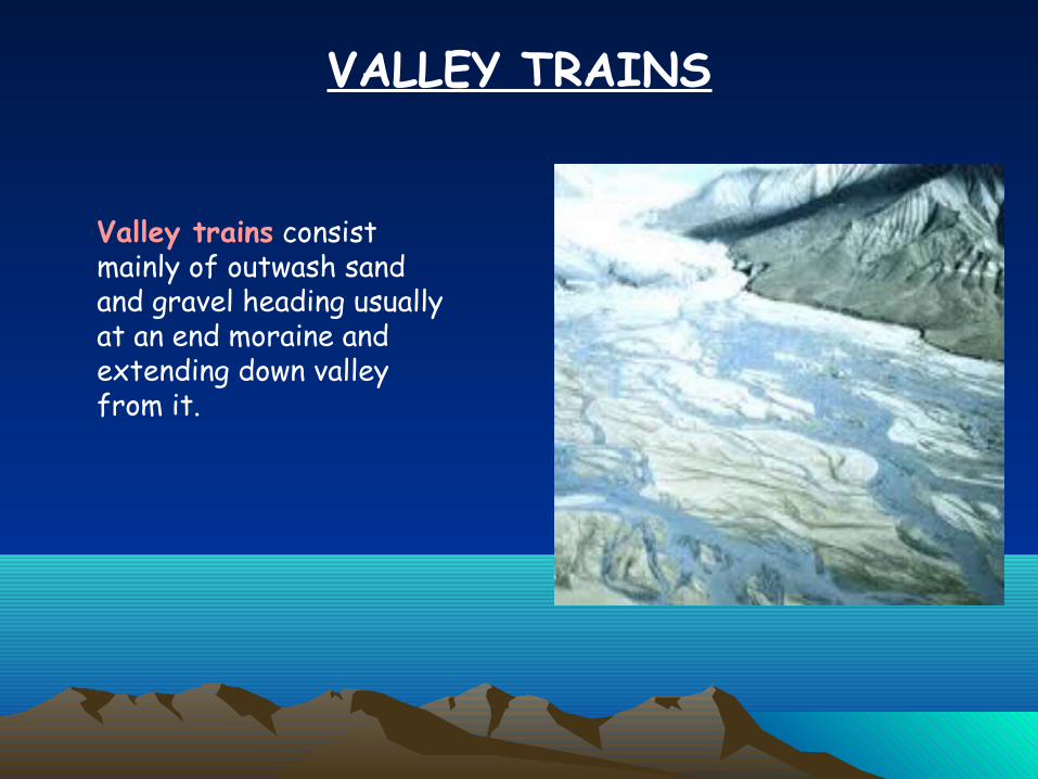
VALLEY TRAINS
Valley trains consist mainly of outwash sand and gravel heading usually at an end moraine and extending down valley from it.

ESKERS
Eskers are sinuous ridges of assorted and somewhat stratified sand and gravel which are believed to represent fillings of super glacial, englacial, or subglacial stream channels.

KAMES AND KAMES TERRACES
Kames terraces may form in glacial troughs, but not too commonly.
Kames terrace are fillings or partial fillings of depressions between a glacier and the sides of its trough. These depression are called fosses.
Kames are caused by sediment deposition from water flowing through a Moulin.

KETTLE LAKE
The ice subsequently melts, resulting in subsidence of overlying material to form kettle.
Kettle lake are formed by melting ice chunks in glacial debris.
Kettle lake

VARVES
Varves are defined as annual sediment layers and they can occur in many different environments.

CREVASSE

BERGSCHRUND

THANK YOU