Embed Size (px)
Citation preview
Document generated on 09/14/2018 2:28 p.m.
Géographie physique et Quaternaire
Glacial History and Stratigraphy of Northwestern NewBrunswick
Martin Rappol
Volume 43, Number 2, 1989
URI: id.erudit.org/iderudit/032769arDOI: 10.7202/032769ar
See table of contents
Publisher(s)
Les Presses de l'Université de Montréal
ISSN 0705-7199 (print)
1492-143X (digital)
Explore this journal
Cite this article
Rappol, M. (1989). Glacial History and Stratigraphy ofNorthwestern New Brunswick. Géographie physique etQuaternaire, 43(2), 191–206. doi:10.7202/032769ar
Article abstract
Two major ice-flow patterns are recognized for the LateWisconsinan ice cover of northwestern New Brunswick andadjacent areas : an early phase in which ice movements weredetermined by the interaction of flow from local accumulationcentres and invading Laurentide ice, and a younger phasewhen an ice-flow pattern developed in response to downdrawfollowing the rise of marine level. The latter resulted in thedevelopment of a residual Appalachian ice divide extendingfrom the Eastern Townships, over northern Maine and NewBrunswick, into Gaspésie. A sedimentary valley fill, up to 60 mthick, occurs in a large part of the St. John River drainagebasin, and predates the latest ice cover. It consists of glaciallake and streamflow deposits, and comprises also apenultimate-glacial lower till deposited by ice moving first inan eastern direction, and later possibly towards south-southwest. Terraces along the St. John River south of GrandFalls are essentially erosional landforms. These were formedpostglacially, keeping pace with erosion of the falls and gorgeat Grand Falls.
This document is protected by copyright law. Use of the services of Érudit (includingreproduction) is subject to its terms and conditions, which can be viewed online.[https://apropos.erudit.org/en/users/policy-on-use/]
This article is disseminated and preserved by Érudit.
Érudit is a non-profit inter-university consortium of the Université de Montréal,Université Laval, and the Université du Québec à Montréal. Its mission is to promoteand disseminate research. www.erudit.org
Tous droits réservés © Les Presses de l'Université deMontréal, 1989
Géographie physique et Quaternaire, 1989, vol. 43, n° 2, p. 191-206, 17 fig.
GLACIAL HISTORY AND STRATIGRAPHY OF NORTHWESTERN NEW BRUNSWICK* Martin RAPPOL, Geological Survey of Canada, 601 Booth Street, Ottawa, Ontario K1A 0 E 8 " .
ABSTRACT Two major ice-flow patterns are recognized for the Late Wisconsinan ice cover of northwestern New Brunswick and adjacent areas : an early phase in which ice movements were determined by the interaction of flow from local accumulation centres and invading Laurentide ice, and a younger phase when an ice-flow pattern developed in response to downdraw following the rise of marine level. The latter resulted in the development of a residual Appalachian ice divide extending from the Eastern Townships, over northern Maine and New Brunswick, into Gaspésie. A sedimentary valley fill, up to 60 m thick, occurs in a large part of the St. John River drainage basin, and predates the latest ice cover. It consists of glacial lake and streamflow deposits, and comprises also a penultimate-glacial lower till deposited by ice moving first in an eastern direction, and later possibly towards south-southwest. Terraces along the St. John River south of Grand Falls are essentially erosional landforms. These were formed postglacially, keeping pace with erosion of the falls and gorge at Grand Falls.
RÉSUMÉ Évolution glaciaire et stratigraphie du nord-ouest du Nouveau-Brunswick. Au cours du Wisconsinien supérieur, deux mouvements glaciaires majeurs caractérisent le nord-ouest du Nouveau-Brunswick et les environs : une première phase pendant laquelle les mouvements glaciaires ont été déterminés par l'interaction d'écoulements à partir de centres d'accumulation locaux et par l'invasion glaciaire laurentidienne, puis une phase plus récente au cours de laquelle un nouveau mode d'écoulement glaciaire s'est élaboré en réponse à l'affaissement qui a suivi la hausse du niveau marin. Au cours de cette dernière phase la ligne de partage des glaces, qui s'est créée dans les Appalaches, s'étendait de l'Estrie (Québec), à travers le Maine et le Nouveau-Brunswick, jusqu'en Gaspésie. Le remblayage de la vallée sur une épaisseur de 60 m, qui s'est produit dans une grande partie du bassin de drainage du Saint-Jean, a précédé la dernière glaciation. Ce remblayage est constitué de dépôts de lac glaciaire et d'écoulement fluviatile et comprend également un pénultième till inférieur mis en place par un glacier qui se déplaçait d'abord vers l'E, puis, plus tard, probablement vers le SSE. Les terrasses le long du Saint-Jean, au sud de Grand Falls, sont essentiellement des formes d'érosion. Ces terrasses d'origine postglaciaire ont été formées en même temps que les chutes et la gorge à Grand Falls.
ZUSAMMENFASSUNG Eiszeitliche En-twicklung und Stratigraphie des Nord-wes-tens von New Brunswick. Fur die Eisbedeckung im Nordwesten von New Brunswick und den angrenzenden Gebieten kônnen im spàten Wisconsin zwei Haupt-Eisflussmuster erkannt werden: eine frùhe Phase, in der die Eisbewegungen durch die Wechselwirkung von Eisabfluss aus ôrtlichen Akkumulationszentren und eindringendem laurentidischem Eis bestimmt waren und eine jùngere Phase, wâhrend der sich als Reaktion auf eine Senkung infolge der Hebung des Meeresspiegels ein Eisflussmuster entwick-elte. Letztere Phase fùhrte zur Entwicklung einer Rest-Eisscheide in den Appalachen, die sich von L'Estrie (Québec) ùber Nord-Maine und New Brunswick bis in die Gaspésie er-streckte. In einem grossen Teil des Drânage-Bassins des St. John-Flusses findet man eine bis zu 60 m dicke Sediment-Talaufschùttung. die der letzten Vereisung vorausgegangen ist. Sie besteht aus Ablagerungen von gla-zialen Seen und Flussabftuss sowie einer vorletzten niedrigeren Grundmoràne, die durch Eis, das sich zuerst in ôstlicher Rich-tung, spàter môglicherweise in sùd-sùdwes-tlicher Richtung bewegte, abgelagert wurde. Die sùdlich von Grand Falls am St. John River gelegenen Terrassen sind im wesentlichen Erosions-Landformen. Diese sind postglaziale Bildungen. die gleichzeitig mit der Erosion der Wasserfàlle und der Schlucht bei Grand Falls entstanden sind.
* Geological Survey of Canada Contribution No. 42888 " Present address : Physical Geography and Soil Science Laboratory. University of Amsterdam, Dapperstraat 115, NL-1093 BS Amsterdam,
The Netherlands.
Manuscrit reçu le 4 novembre 1988; manuscrit révisé accepté le 21 décembre 1988
192 M. RAPPOL
INTRODUCTION
Rediscovery of northward ice-flow indicators, first described by Ells and Chalmers (see Chauvin et al., 1985) in the Appalachians of eastern Canada (Lamarche, 1971 ; Lottie, 1976; Martineau, 1979; among others) has greatly stimulated Quaternary research and the development of new glaciation models in the Appalachian region (e.g. Gadd et al., 1972; Shilts, 1976, 1981; Grant, 1977; LaSaIIe et al., 1977; Prest, 1984; Rampton et al., 1984; Lowell and Kite, 1986a,b,; David and Lebuis, 1985; Hughes et al., 1985). For a large part of the region, relevant and detailed information on glaciation and Quaternary stratigraphy is still sparse, however, and it is therefore understandable that reconstructions of glacial history may differ considerably among authors.
The development and location of a Late Wisconsinan Appalachian ice divide, extending from the Eastern Townships of southern Québec, across northern Maine and New Brunswick, to the Gaspé Peninsula appears to be well established and accepted. However, events prior to this development are still poorly defined in most of the area.
Thick Quaternary fill is present in the St. John River Valley and some of its tributaries. The nature of this fill has been deduced from logging cores from bore-holes and from natural and gravel pit sections south of Grand Falls. At least two subglacial tills are present that correspond with two different glacial episodes, and are separated by thick glaciolacustrine and glaciofluvial deposits.
In this paper, morphogenesis and sedimentary history of the St. John River Valley, earlier discussed by Lee (1959a, 1959b) and Rampton et al. (1984), are reassessed on the basis of an analysis of valley fill deposits and ice-flow directions.
SETTING
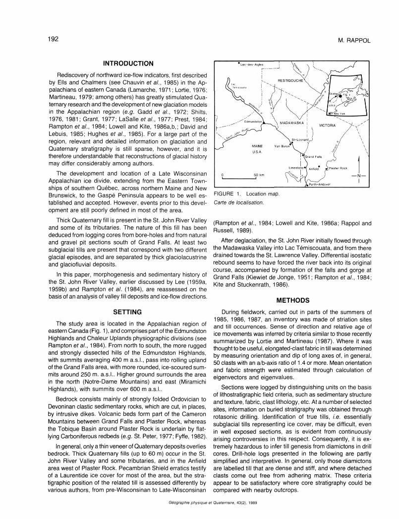
The study area is located in the Appalachian region of eastern Canada (Fig. 1 ), and comprises part of the Edmundston Highlands and Chaleur Uplands physiographic divisions (see Rampton era/., 1984). From north to south, the more rugged and strongly dissected hills of the Edmundston Highlands, with summits averaging 400 m a.s.I., pass into rolling upland of the Grand Falls area, with more rounded, ice-scoured summits around 250 m. a.s.L Higher ground surrounds the area in the north (Notre-Dame Mountains) and east (Miramichi Highlands), with summits over 600 m a.s.L
Bedrock consists mainly of strongly folded Ordovician to Devoninan clastic sedimentary rocks, which are cut, in places, by intrusive dikes. Volcanic beds form part of the Cameron Mountains between Grand Falls and Plaster Rock, whereas the Tobique Basin around Plaster Rock is underlain by flat-lying Carboniferous redbeds (e.g. St. Peter, 1977; Fyffe, 1982).
In general, only a thin veneer of Quaternary deposits overlies bedrock. Thick Quaternary fills (up to 60 m) occur in the St. John River Valley and some tributaries, and in the Anfield area west of Plaster Rock. Pecambrian Shield erratics testify of a Laurentide ice cover for most of the area, but the stratigraphie position of the related till is assessed differently by various authors, from pre-Wisconsinan to Late-Wisconsinan
FIGURE 1. Location map.
Carte de localisation.
(Rampton et al., 1984; Lowell and Kite, 1986a; Rappol and Russell, 1989).
After déglaciation, the St. John River initially flowed through the Madawaska Valley into Lac Témiscouata, and from there drained towards the St. Lawrence Valley. Differential isostatic rebound seems to have forced the river back into its original course, accompanied by formation of the falls and gorge at Grand Falls (Kiewiet de Jonge, 1951 ; Rampton et al., 1984; Kite and Stuckenrath, 1986).
METHODS
During fieldwork, carried out in parts of the summers of 1985, 1986, 1987, an inventory was made of striation sites and till occurrences. Sense of direction and relative age of ice movements was inferred by criteria similar to those recently summarized by Lortie and Martineau (1987). Where it was thought to be useful, elongated-clast fabric in till was determined by measuring orientation and dip of long axes of, in general, 50 clasts with an a/b-axis ratio of 1.4 or more. Mean orientation and fabric strength were estimated through calculation of eigenvectors and eigenvalues.
Sections were logged by distinguishing units on the basis of lithostratigraphic field criteria, such as sedimentary structure and texture, fabric, clast lithology, etc. At a number of selected sites, information on buried stratigraphy was obtained through rotasonic drilling. Identification of true tills, I.e. essentially subglacial tills representing ice cover, may be difficult, even in well exposed sections, as is evident from continuously arising controversies in this respect. Consequently, it is extremely hazardous to infer till genesis from diamictons in drill cores. Drill-hole logs presented in the following are partly simplified and interpretive. In general, only those diamictons are labelled till that are dense and stiff, and where detached clasts come out free from adhering matrix. These criteria appear to be satisfactory where core stratigraphy could be compared with nearby outcrops.
Géographie physique el Quaternaire. 43(2). 1989
GLACIAL HISTORY AND STRATIGRAPHY 193
DIRECTION AND RELATIVE AGE OF ICE MOVEMENTS
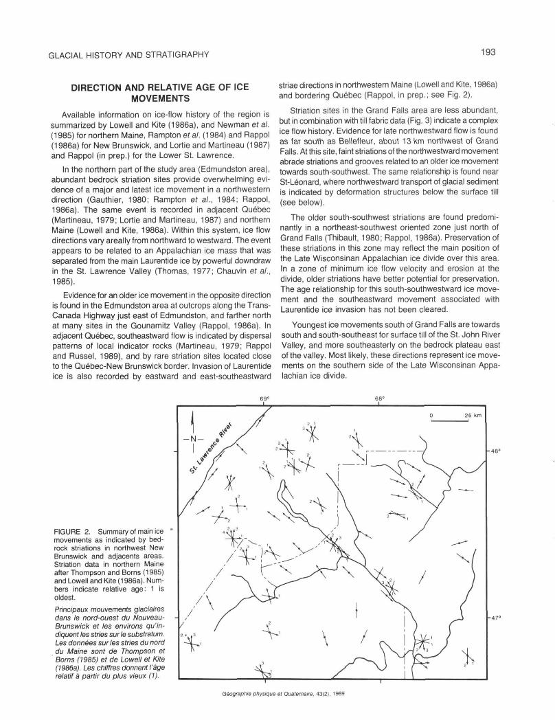
Available information on ice-flow history of the region is summarized by Lowell and Kite (1986a), and Newman et al. (1985) for northern Maine, Rampton era/. (1984) and Rappol (1986a) for New Brunswick, and Lortie and Martineau (1987) and Rappol (in prep.) for the Lower St. Lawrence.
In the northern part of the study area (Edmundston area), abundant bedrock striation sites provide overwhelming evidence of a major and latest ice movement in a northwestern direction (Gauthier, 1980; Rampton et a/., 1984; Rappol, 1986a). The same event is recorded in adjacent Québec (Martineau, 1979; Lortie and Martineau, 1987) and northern Maine (Lowell and Kite, 1986a). Within this system, ice flow directions vary areally from northward to westward. The event appears to be related to an Appalachian ice mass that was separated from the main Laurentide ice by powerful downdraw in the St. Lawrence Valley (Thomas, 1977; Chauvin et al., 1985).
Evidence for an older ice movement in the opposite direction is found in the Edmundston area at outcrops along the Trans-Canada Highway just east of Edmundston, and farther north at many sites in the Gounamitz Valley (Rappol, 1986a). In adjacent Québec, southeastward flow is indicated by dispersal patterns of local indicator rocks (Martineau, 1979; Rappol and Russel, 1989), and by rare striation sites located close to the Québec-New Brunswick border. Invasion of Laurentide ice is also recorded by eastward and east-southeastward
striae directions in northwestern Maine (Lowell and Kite, 1986a) and bordering Québec (Rappol, in prep.; see Fig. 2).
Striation sites in the Grand Falls area are less abundant, but in combination with till fabric data (Fig. 3) indicate a complex ice flow history. Evidence for late northwestward flow is found as far south as Bellefleur, about 13 km northwest of Grand Falls. At this site, faint striations of the northwestward movement abrade striations and grooves related to an older ice movement towards south-southwest. The same relationship is found near St-Léonard, where northwestward transport of glacial sediment is indicated by deformation structures below the surface till (see below).
The older south-southwest striations are found predominantly in a northeast-southwest oriented zone just north of Grand Falls (Thibault, 1980; Rappol, 1986a). Preservation of these striations in this zone may reflect the main position of the Late Wisconsinan Appalachian ice divide over this area. In a zone of minimum ice flow velocity and erosion at the divide, older striations have better potential for preservation. The age relationship for this south-southwestward ice movement and the southeastward movement associated with Laurentide ice invasion has not been cleared.
Youngest ice movements south of Grand Falls are towards south and south-southeast for surface till of the St. John River Valley, and more southeasterly on the bedrock plateau east of the valley. Most likely, these directions represent ice movements on the southern side of the Late Wisconsinan Appalachian ice divide.
FIGURE 2. Summary of main ice movements as indicated by bedrock striations in northwest New Brunswick and adjacents areas. Striation data in northern Maine after Thompson and Borns (1985) and Lowell and Kite (1986a). Numbers indicate relative age: 1 is oldest.
Principaux mouvements glaciaires dans le nord-ouest du Nouveau-Bruns wick et les environs qu'indiquent /es stries sur le substratum. Les données sur les stries du nord du Maine sont de Thompson et Borns (1985) et de Lowell et Kite (1986a). Les chiffres donnent l'âge relatif à partir du plus vieux (1).
Géographie physique el Quaternaire. 43(2), 1989
194 M. RAPPOL
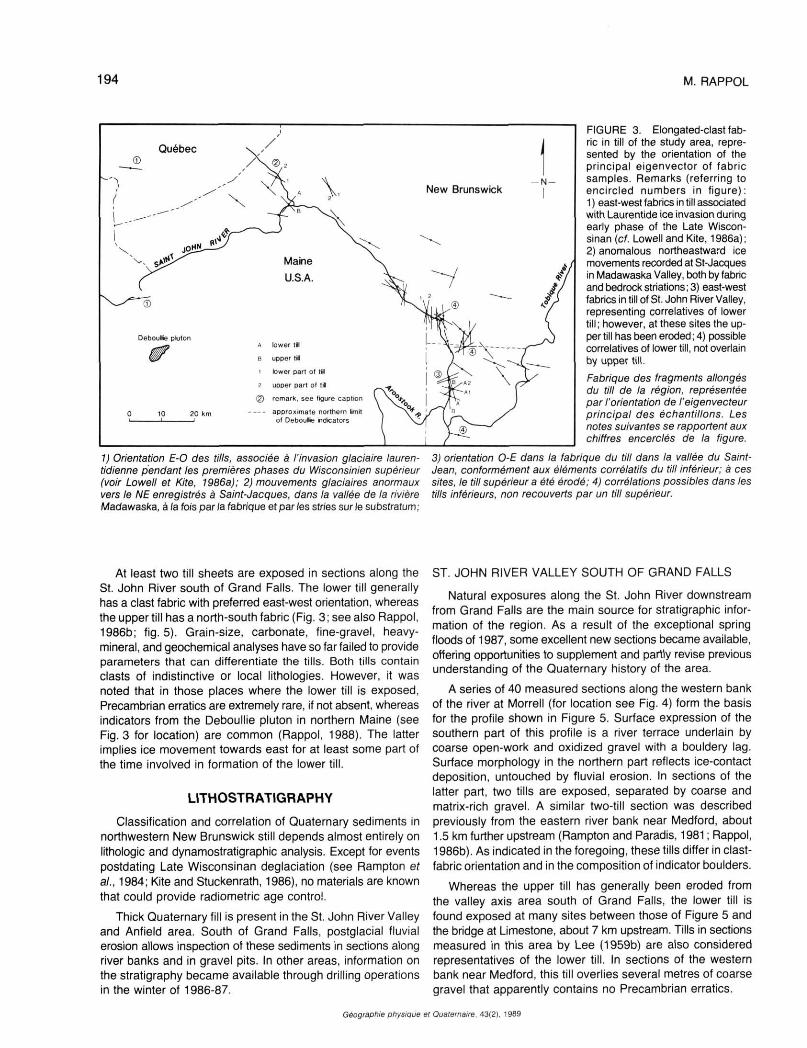
1) Orientation E-O des tills, associée à l'invasion glaciaire lauren-tidienne pendant les premières phases du Wisconsinien supérieur (voir Lowell et Kite, 1986a); 2) mouvements glaciaires anormaux vers le NE enregistrés à Saint-Jacques, dans la vallée de la rivière Madawaska, à la fois parla fabrique et par les stries sur le substratum;
FIGURE 3. Elongated-clast fabric in till of the study area, represented by the orientation of the principal eigenvector of fabric samples. Remarks (referring to encircled numbers in figure): 1 ) east-west fabrics in till associated with Laurentide ice invasion during early phase of the Late Wiscon-sinan (cf. Lowell and Kite, 1986a); 2) anomalous northeastward ice movements recorded at St-Jacques in Madawaska Valley, both by fabric and bedrock striations; 3) east-west fabrics in till of St. John River Valley, representing correlatives of lower till; however, at these sites the upper till has been eroded; 4) possible correlatives of lower till, not overlain by upper till.
Fabrique des fragments allongés du till de la région, représentée par l'orientation de l'eigenvecteur principal des échantillons. Les notes suivantes se rapportent aux chiffres encerclés de la figure.
3) orientation 0-E dans la fabrique du till dans la vallée du Saint-Jean, conformément aux éléments corrélatifs du till inférieur; à ces sites. Ie till supérieur a été èrodé; 4) corrélations possibles dans les tills inférieurs, non recouverts par un till supérieur.
At least two till sheets are exposed in sections along the St. John River south of Grand Falls. The lower till generally has a clast fabric with preferred east-west orientation, whereas the upper till has a north-south fabric (Fig. 3; see also Rappol, 1986b; fig. 5). Grain-size, carbonate, fine-gravel, heavy-mineral, and geochemical analyses have so far failed to provide parameters that can differentiate the tills. Both tills contain clasts of indistinctive or local lithologies. However, it was noted that in those places where the lower till is exposed, Precambrian erratics are extremely rare, if not absent, whereas indicators from the Deboullie pluton in northern Maine (see Fig. 3 for location) are common (Rappol, 1988). The latter implies ice movement towards east for at least some part of the time involved in formation of the lower till.
LITHOSTRATIGRAPHY
Classification and correlation of Quaternary sediments in northwestern New Brunswick still depends almost entirely on lithologie and dynamostratigraphic analysis. Except for events postdating Late Wisconsinan déglaciation (see Rampton et al., 1984; Kite and Stuckenrath, 1986), no materials are known that could provide radiometric age control.
Thick Quaternary fill is present in the St. John River Valley and Anfield area. South of Grand Falls, postglacial fluvial erosion allows inspection of these sediments in sections along river banks and in gravel pits. In other areas, information on the stratigraphy became available through drilling operations in the winter of 1986-87.
ST. JOHN RIVER VALLEY SOUTH OF GRAND FALLS
Natural exposures along the St. John River downstream from Grand Falls are the main source for stratigraphie information of the region. As a result of the exceptional spring floods of 1987, some excellent new sections became available, offering opportunities to supplement and partly revise previous understanding of the Quaternary history of the area.
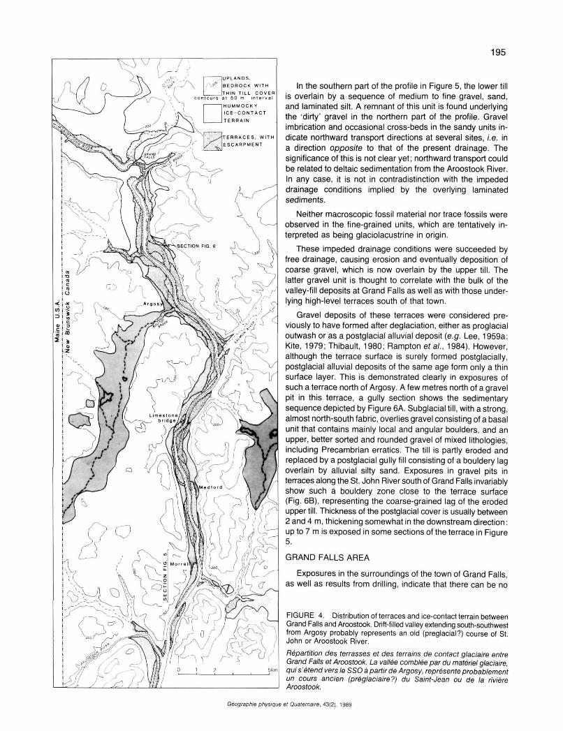
A series of 40 measured sections along the western bank of the river at Morrell (for location see Fig. 4) form the basis for the profile shown in Figure 5. Surface expression of the southern part of this profile is a river terrace underlain by coarse open-work and oxidized gravel with a bouldery lag. Surface morphology in the northern part reflects ice-contact deposition, untouched by fluvial erosion. In sections of the latter part, two tills are exposed, separated by coarse and matrix-rich gravel. A similar two-till section was described previously from the eastern river bank near Medford, about 1.5 km further upstream (Rampton and Paradis, 1981 ; Rappol, 1986b). As indicated in the foregoing, these tills differ in clast-fabric orientation and in the composition of indicator boulders.
Whereas the upper till has generally been eroded from the valley axis area south of Grand Falls, the lower till is found exposed at many sites between those of Figure 5 and the bridge at Limestone, about 7 km upstream. Tills in sections measured in this area by Lee (1959b) are also considered representatives of the lower till. In sections of the western bank near Medford, this till overlies several metres of coarse gravel that apparently contains no Precambrian erratics.
Géographie physique el Quaternaire. 43(2), 1989
Géographie physi
195
In the southern part of the profile in Figure 5, the lower till is overlain by a sequence of medium to fine gravel, sand, and laminated silt. A remnant of this unit is found underlying the "dirty' gravel in the northern part of the profile. Gravel imbrication and occasional cross-beds in the sandy units indicate northward transport directions at several sites, i.e. in a direction opposite to that of the present drainage. The significance of this is not clear yet; northward transport could be related to deltaic sedimentation from the Aroostook River. In any case, it is not in contradistinction with the impeded drainage conditions implied by the overlying laminated sediments.
Neither macroscopic fossil material nor trace fossils were observed in the fine-grained units, which are tentatively interpreted as being glaciolacustrine in origin.
These impeded drainage conditions were succeeded by free drainage, causing erosion and eventually deposition of coarse gravel, which is now overlain by the upper till. The latter gravel unit is thought to correlate with the bulk of the valley-fill deposits at Grand Falls as well as with those underlying high-level terraces south of that town.
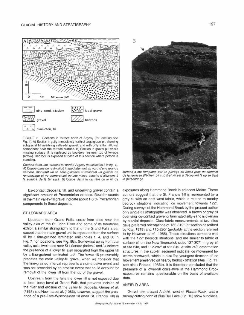
Gravel deposits of these terraces were considered previously to have formed after déglaciation, either as proglacial outwash or as a postglacial alluvial deposit (e.g. Lee, 1959a; Kite, 1979; Thibault, 1980; Rampton et al., 1984). However, although the terrace surface is surely formed postglacially, postglacial alluvial deposits of the same age form only a thin surface layer. This is demonstrated clearly in exposures of such a terrace north of Argosy. A few metres north of a gravel pit in this terrace, a gully section shows the sedimentary sequence depicted by Figure 6A. Subglacial till, with a strong, almost north-south fabric, overlies gravel consisting of a basal unit that contains mainly local and angular boulders, and an upper, better sorted and rounded gravel of mixed lithologies, including Precambrian erratics. The till is partly eroded and replaced by a postglacial gully fill consisting of a bouldery lag overlain by alluvial silty sand. Exposures in gravel pits in terraces along the St. John River south of Grand Falls invariably show such a bouldery zone close to the terrace surface (Fig. 6B), representing the coarse-grained lag of the eroded upper till. Thickness of the postglacial cover is usually between 2 and 4 m, thickening somewhat in the downstream direction : up to 7 m is exposed in some sections of the terrace in Figure 5.
GRAND FALLS AREA
Exposures in the surroundings of the town of Grand Falls, as well as results from drilling, indicate that there can be no
FIGURE 4. Distribution of terraces and ice-contact terrain between Grand Falls and Aroostook. Drift-filled valley extending south-southwest from Argosy probably represents an old (preglacial?) course of St. John or Aroostook River.
Répartition des terrasses et des terrains de contact glaciaire entre Grand Falls et Aroostook. La vallée comblée par du matériel glaciaire, qui s'étend vers le SSO à partir de Argosy, représente probablement un cours ancien (préglaciaire?) du Saint-Jean ou de la rivière Aroostook.
et Quaternaire, 43(2), 1989

196 M. RAPPOL
FIGURE 5. River section at Morrell (for location see Fig. 4). Major gravel units represent, from young to old: postglacial alluvial gravel, with basal bouldery lag, associated with terrace formation ; ice contact deposits (overlying upper till); and inter-till gravel correlated with main valley fill at Grand Falls.
Coupe de la rivière à la hauteur de Morrell (localisation à la fig. 4). De la plus jeune à la plus vieille, les principales unités de graviers sont les suivantes: gravier alluvionnaire postglaciaire, avec pavage de blocs, associé à la formation des terrasses; dépôts de contact glaciaire (surmontant le till supérieur); gravier entre deux couches de till qui correspond au matériel de remblayage à Grand Falls.
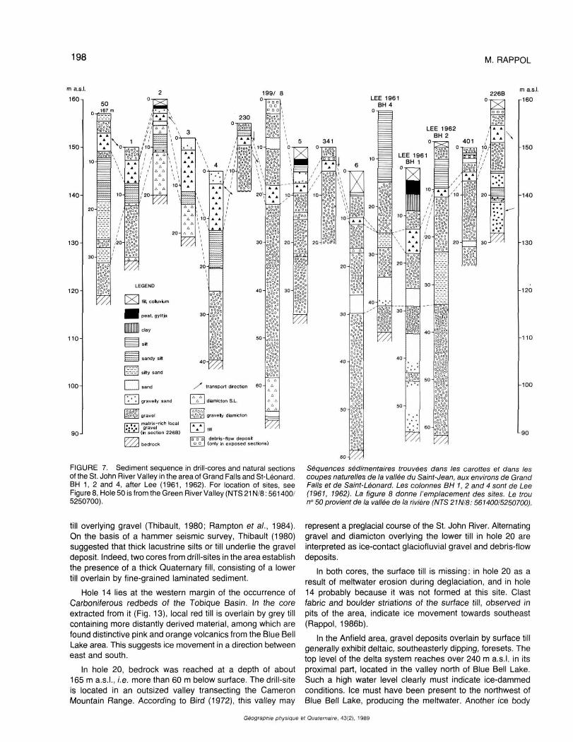
doubt here that the thick valley fill is overlain by till (Fig. 7, for locations see Fig. 8A). Stratigraphie position and fabric of this till suggest that it corresponds with the upper till in sections downstream from Grand Falls.
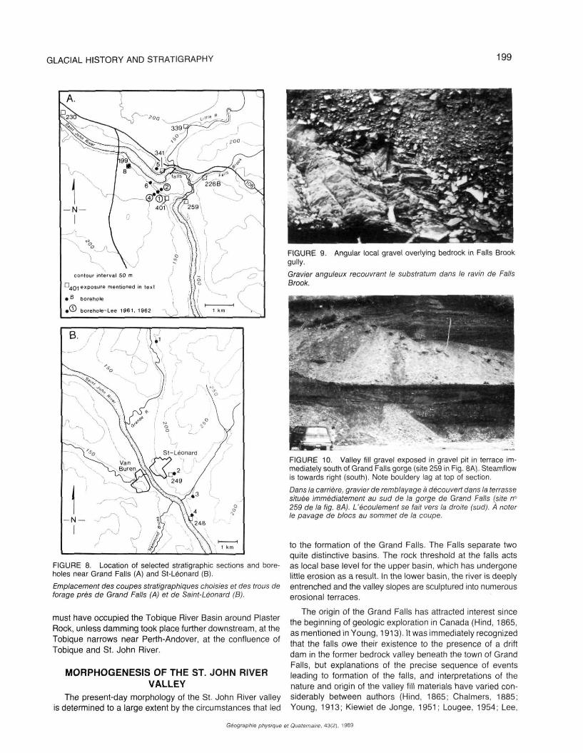
The ancient course of the St. John River runs beneath the town of Grand Falls and is entirely filled with drift (Lee, 1961, 1962: see Fig. 7). The valley of a tributary was also filled in, but postglacial erosion by Falls Brook has partly removed this fill. Falls Brook is presently deeply incised and mostly flowing on bedrock.
The base of the sedimentary fill of the Falls Brook valley comprises up to 15 m of local gravel overlying bedrock (Fig. 9). This local gravel' unit is an almost monolithic, angular, poorly-sorted, and matrix-rich gravel, that is near its base locally reminiscent of grèzes litées deposits. Throughout the length of its exposure, this local gravel contains a unit of laminated silt and fine sand, up to 2 m thick (Rappol, 1986b: figure 18), in places containing numerous dropstones with their long axis in a vertical position. These features, and the absence of pollen in the fine-grained unit, suggest cold-climate conditions during formation of the local gravel and lacustrine interval. The significance of local gravel deposits in general is not clear. These were also observed at the base of sections north of Argosy (Fig. 6), in Boutot Brook, and in terraces on the east bank just south of Limestone (for locations, see Fig. 4), and are always overlain by better sorted and rounded gravel with a more variable lithologie composition, including Pre-cambrian erratics. Near Argosy, the local gravel contains, besides local diabase and shale, many very well rounded
light brown quartzites, perhaps suggesting a prolonged ero-sional interval.
A lower till is possibly present at the base of hole 8 (Fig. 7). At site 339 in the Little River Valley (see Fig. 8), till with a consistent east-west fabric (two samples) overlies 12 m of gravel resting on bedrock. Otherwise, no clear indications for the presence of two tills in the Grand Falls area were found. As shown in Figure 7, valley-fill deposits consist predominantly of sorted, waterlain deposits.
A major part of the valley fill is exposed near the mouth of the Grand Falls gorge in a gully and gravel pit, sites 401 and 259, respectively (Fig. 8). It consists of a fairly monotonous sequence of subhorizontally bedded medium to five gravel, with occasional cross-beds and sandy layers (Fig. 10), suggesting a gradual aggradational event. Three core logs published by Lee (1961, 1962) and the record of hole 6 (Fig. 7) show a fairly consistent fine-grained interval just above 115 m a.s.I..
Most exposures and drill cores show 2-5 m of till overlying the main valley-fill gravel. Clast-fabric orientation in this till, in combination with available information from bedrock striation sites, indicates ice movement towards south or south-southeast in the St. John River Valley, and towards southeast in the uplands east of the valley.
This till is either overlain by ice-contact gravel and sand deposits, frequently capped by poorly-sorted debris flows (till flows), or by laminated fine-grained sediment and related sandy-gravelly beach deposits of lacustrine origin.
Géographie physique et Quaternaire. 43(2), 1989
GLACIAL HISTORY AND STRATIGRAPHY 197
FIGURE 6. Sections in terrace north of Argosy (for location see Fig. 4). A) Section in gully immediately north of large gravel pit, showing subglacial till overlying valley-fill gravel, and with only a thin alluvial component near the terrace surface. B) Section in gravel pit where missing surface till is replaced by bouldery lag near top of terrace (arrow). Bedrock is exposed at base of this section where person is standing.
Coupes dans une terrasse au nord d'Argosy (localisation à la fig. 4). A) Coupe dans un ravin situé immédiatement au nord d'une grande carrière, montrant un till sous-glaciaire surmontant un gravier de remblayage et ne comprenant qu'une mince couche d'alluvions à la surface de la terrasse. B) Coupe dans la carrière où le till de
surface a été remplacé par un pavage de blocs prés du sommet de la terrasse (flèche). Le substratum est à découvert là où se tient le personnage.
Ice-contact deposits, till, and underlying gravel contain a significant amount of Precambrian erratics. Boulder counts in the main valley-fill gravel indicate about 1 -3 % Precambrian components in these deposits.
ST-LÉONARD AREA
Upstream from Grand Falls, cores from sites near the valley axis of the St. John River and some of its tributaries exhibit a similar stratigraphy to that of the Grand Falls area, except that the main gravel unit is separated from the surface till by a fine-grained laminated unit (holes 1, 4, and 50 in Fig. 7; for locations, see Fig. 8B). Somewhat away from the valley axis, two holes near St-Leonard (holes 2 and 3) indicate the presence of a lower till also separated from the upper till by a fine-grained laminated unit. The lower till presumably predates the main valley-fill gravel, when we consider that the fine-grained interval represents a non-erosive event and was not preceded by an erosive event that could account for removal of the lower till from the top of the gravel.
Upstream from the falls the lower till is not exposed due to local base level at Grand Falls that prevents incision of the river and erosion of the valley fill deposits. Genes et al. (1981) and Newman etal. (1985), however, suggest the presence of a pre-Late-Wisconsinan till (their St. Francis Till) in
exposures along Hammond Brook in adjacent Maine. These authors suggest that the St. Francis Till is represented by a grey till with an east-west fabric, which is related to nearby bedrock striations indicating ice movement towards 122°. During surveys of the Hammond Brook by the present author only single-till stratigraphy was observed. A brown or grey till overlying ice-contact gravel or laminated silty-sand is overlain by alluvial deposits. Clast-fabric measurements at two sites gave preferred orientations of 132-312° (at section described by Kite, 1979) and 110-290° (probably at the section referred to by Newman et al., 1985). These directions compare well with the 122° bedrock striations, and are similar to fabric of surface till on the New Brunswick side: 127-307° in grey till at site 248, and 112-292° at site 249. At site 249, deformation structures in the sub-till sediment indicate ice movement towards northwest, which is also the youngest direction of ice movement preserved on nearby bedrock striation sites (Fig. 11 ; see also: Rappol, 1986b). It is therefore concluded that the presence of a lower-till correlative in the Hammond Brook exposures remains questionable on the basis of available data.
ANFIELD AREA
Gravel pits around Anfield, west of Plaster Rock, and a railway cutting north of Blue Bell Lake (Fig. 12) show subglacial
Géographie physique et Quaternaire, 43(2), 1989
198 M. RAPPOL
FIGURE 7. Sediment sequence in drill-cores and natural sections Séquences sédimentaires trouvées dans les carottes et dans les of the St. John River Valley in the area of Grand Falls and St-Léonard. coupes naturelles de la vallée du Saint-Jean, aux environs de Grand BH 1, 2 and 4, after Lee (1961, 1962). For location of sites, see Falls et de Saint-Léonard. Les colonnes BH 1, 2 and 4 sont de Lee Figure 8, Hole 50 is from the Green River Valley (NTS 21 N/8:561400/ (7967, 7962J. La figure 8 donne l'emplacement des sites. Le trou 5250700). n° 50 provient de la vallée de la rivière (NTS21N/8:561400/5250700).
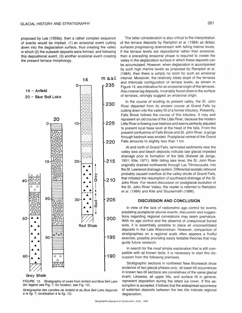
till overlying gravel (Thibault, 1980; Rampton et al., 1984). On the basis of a hammer seismic survey, Thibault (1980) suggested that thick lacustrine silts or till underlie the gravel deposit. Indeed, two cores from drill-sites in the area establish the presence of a thick Quaternary fill, consisting of a lower till overlain by fine-grained laminated sediment.
Hole 14 lies at the western margin of the occurrence of Carboniferous redbeds of the Tobique Basin. In the core extracted from it (Fig. 13), local red till is overlain by grey till containing more distantly derived material, among which are found distinctive pink and orange volcanics from the Blue Bell Lake area. This suggests ice movement in a direction between east and south.
In hole 20, bedrock was reached at a depth of about 165 m a.s.l., i.e. more than 60 m below surface. The drill-site is located in an outsized valley transecting the Cameron Mountain Range. According to Bird (1972), this valley may
represent a preglacial course of the St. John River. Alternating gravel and diamicton overlying the lower till in hole 20 are interpreted as ice-contact glaciofluvial gravel and debris-flow deposits.
In both cores, the surface till is missing: in hole 20 as a result of meltwater erosion during déglaciation, and in hole 14 probably because it was not formed at this site. Clast fabric and boulder striations of the surface till, observed in pits of the area, indicate ice movement towards southeast (Rappol, 1986b).
In the Anfield area, gravel deposits overlain by surface till generally exhibit deltaic, southeasterly dipping, foresets. The top level of the delta system reaches over 240 m a.s.l. in its proximal part, located in the valley north of Blue Bell Lake. Such a high water level clearly must indicate ice-dammed conditions. Ice must have been present to the northwest of Blue Bell Lake, producing the meltwater. Another ice body
Géographie physique et Quaternaire. 43(2). 1989
GLACIAL HISTORY AND STRATIGRAPHY 199
FIGURE 8. Location of selected stratigraphie sections and boreholes near Grand Falls (A) and St-Leonard (B).
Emplacement des coupes stratigraphiques choisies et des trous de forage près de Grand Falls (A) et de Saint-Léonard (B).
must have occupied the Tobique River Basin around Plaster Rock, unless damming took place further downstream, at the Tobique narrows near Perth-Andover, at the confluence of Tobique and St. John River.
MORPHOGENESIS OF THE ST. JOHN RIVER VALLEY
The present-day morphology of the St. John River valley is determined to a large extent by the circumstances that led
FIGURE 9. Angular local gravel overlying bedrock in Falls Brook gully.
Gravier anguleux recouvrant le substratum dans le ravin de Falls Brook.
FIGURE 10. Valley fill gravel exposed in gravel pit in terrace immediately south of Grand Falls gorge (site 259 in Fig. 8A). Steamflow is towards right (south). Note bouldery lag at top of section.
Dans la carrière, gravier de remblayage à découvert dans la terrasse située immédiatement au sud de la gorge de Grand Falls (site n° 259 de la fig. 8A). L'écoulement se fait vers la droite (sud). A noter le pavage de blocs au sommet de la coupe.
to the formation of the Grand Falls. The Falls separate two quite distinctive basins. The rock threshold at the falls acts as local base level for the upper basin, which has undergone little erosion as a result. In the lower basin, the river is deeply entrenched and the valley slopes are sculptured into numerous erosional terraces.
The origin of the Grand Falls has attracted interest since the beginning of geologic exploration in Canada (Hind, 1865, as mentioned in Young, 1913). It was immediately recognized that the falls owe their existence to the presence of a drift dam in the former bedrock valley beneath the town of Grand Falls, but explanations of the precise sequence of events leading to formation of the falls, and interpretations of the nature and origin of the valley fill materials have varied considerably between authors (Hind, 1865; Chalmers, 1885; Young, 1913; Kiewiet de Jonge, 1951; Lougee, 1954; Lee,
Géographie physique et Quaternaire. 43(2), 1989
200
FIGURE 11. Deformed sub-till sediment at site 249 near St-Léonard (for location see Fig. 8B). Ice movement towards right (northwest). A) Overturned beds. B) Drag fold with down glacier pointing fold-nose.
Sédiment déformé sous-jacent au till au site n° 249, près de Saint-Léonard (localisation à Ia fig. 8). L'écoulement glaciaire se faisait vers la droite (nord-ouest). A) couches déversées B) pli d'entraînement, l'aval étant vers la courbe du pli.
1959a; Kite, 1979; Gauthier, 1980; Thibault, 1980; Rampton étal., 1984).
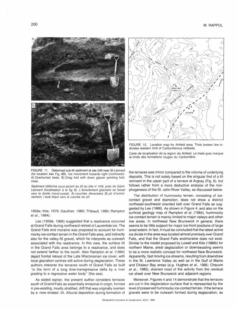
Lee (1959a, 1966) suggested that a readvance occurred at Grand Falls during northward retreat of Laurentide ice. The Grand Falls end moraine was proposed to account for hum-mocky ice-contact terrain in the Grand Falls area, and indirectly also for the valley-fill gravel, which he interprets as outwash associated with the readvance. In this view, the surface till in the Grand Falls area belongs to a readvance, and does not extend farther to the south. Also Rampton et al. (1984) depict frontal retreat of the Late Wisconsinan ice cover, with local glaciation centres still active during déglaciation. These authors interpret the terraces south of Grand Falls as built "in the form of a long time-transgressive delta by a river grading to a regressive water body" (the sea).
As stated earlier, the present author considers terraces south of Grand Falls as essentially erosional in origin, formed in pre-existing, mostly stratified, drift that was originally overlain by a -now eroded- till. Alluvial deposition during formation of
Géographie physique
M. RAPPOL
FIGURE 12. Location map for Anfield area. Thick broken line indicates western limit of Carboniferous redbeds.
Carte de localisation de la région de Anfield. Le tireté gras marque la limite des formations rouges du Carbonifère.
the terraces was minor compared to the volume of underlying deposits. This is not solely based on the singular find of a till remnant in the upper part of a terrace at Argosy (Fig. 6), but follows rather from a more deductive analysis of the morphogenesis of the St. John River Valley, as discussed below.
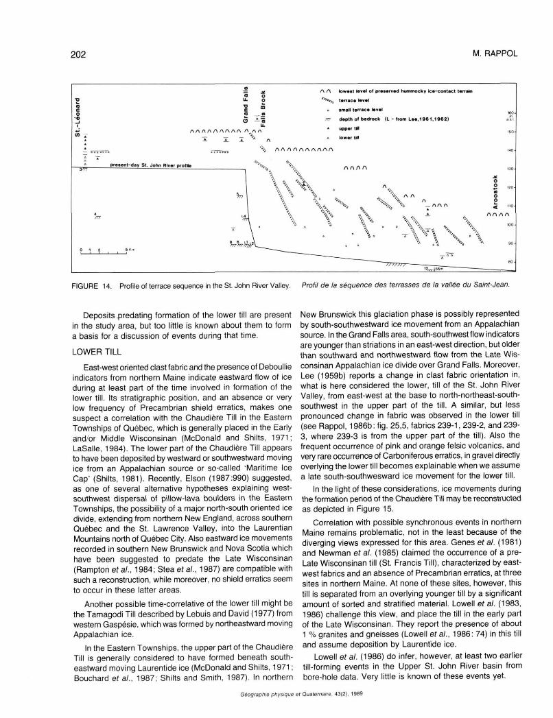
The distribution of hummocky terrain, consisting of ice-contact gravel and diamicton, does not show a distinct northeast-southwest oriented belt over Grand Falls as suggested by Lee (1966). As shown in Figure 4, and also on the surficial geology map of Rampton et al. (1984), hummocky ice-contact terrain is mainly limited to major valleys and other low areas. In northwest New Brunswick in general, there seems to be little support for major ice-front positions of large areal extent. In fact, it must be concluded that the latest active ice divide in the area was located almost precisely over Grand Falls, and that the Grand Falls endmoraine does not exist. Similar to the model proposed by Lowell and Kite (1986b) for northern Maine, areal déglaciation or downswasting seems to be a more realistic concept for northwest New Brunswick. Apparently, fast moving ice streams, resulting from downdraw in the St. Lawrence Valley as well as in the Gulf of Maine and Chaleur Bay areas (e.g. Hughes et al., 1985; Chauvin et al., 1985), drained most of the activity from the residual ice sheet over New Brunswick and adjacent regions.
Moreover, Figures 4 and 14 demonstrate that the terraces are cut in the déglaciation surface that is represented by the level of preserved hummocky ice-contact terrain. If the terrace gravels were to be outwash formed during déglaciation, as
Quaternaire, 43(2), 1989
GLACIAL HISTORY AND STRATIGRAPHY 201
proposed by Lee (1959a), then a rather complex sequence of events would be implied: (1)an erosional event cutting down into the déglaciation surface, thus creating the valley in which (2) the outwash deposits were formed, and following this depositional event, (3) another erosional event creating the present terrace morphology.
Grey Shale
FIGURE 13. Stratigraphy of cores from Anfield and Blue Bell Lake (for legend see Fig. 7; for location, see Fig. 12).
Stratigraphie des carottes de Anfield et de Blue Bell Lake (légende à la fig. 7; localisation à la fig. 12).
The latter consideration is also critical to the interpretation of the terrace deposits by Rampton et al. (1984) as deltaic surfaces progressing downstream with falling marine levels. If the terrace levels are depositional rather than erosional, then a preceding erosional phase is required to create the valley in the déglaciation surface in which these deposits can be accumulated. However, when déglaciation is accompanied by such high marine levels as proposed by Rampton et al. (1984), then there is simply no room for such an erosional interval. Moreover, the relatively steep slope of the terraces and imbricate configuration of terrace levels, as shown in Figure 14, are indicative for an erosional origin of the terraces. Also coarse lag deposits, invariably found close to the surface of terraces, strongly suggest an erosional origin.
In the course of eroding its present valley, the St. John River departed from its ancient course at Grand Falls by cutting down into the valley fill of a former tributary. Presently, Falls Brook follows the course of this tributary. It may well represent an old course of the Little River, because the modern Little River is flowing over bedrock and seems perfectly adjusted to present local base level at the head of the falls. From the present confluence of Falls Brook and St. John River, a gorge through bedrock was eroded. Postglacial retreat of the Grand Falls amounts to slightly less than 1 km
At and north of Grand Falls, laminated sediments near the valley axis and beach deposits indicate late glacial impeded drainage prior to formation of the falls (Kiewiet de Jonge, 1951 ; Kite, 1971). With falling lake level, the St. John River originally drained northwards through Lac Témiscouata, into the St. Lawrence drainage system. Differential isostatic rebound probably caused overflow at the valley-divide of Grand Falls, that initiated the resumption of southward drainage of the St. John River. For recent discussion on postglacial evolution of the St. John River Valley, the reader is referred to Rampton era/. (1984) and Kite and Stuckenrath (1986).
DISCUSSION AND CONCLUSION
In view of the lack of radiometric age control for events predating postglacial alluvial events, discussion and suggestions regarding regional correlations may seem premature. With no age control and the absence of unequivocal buried soils, it is essentially possible to place all unconsolidated deposits in the Late Wisconsinan. However, comparison of stratigraphies on a regional scale often appears a fruitful exercise, possibly providing easily testable theories that may guide future research.
In search for the most simple explanation that is still compatible with all known facts, it is necessary to start this discussion from the following premises.
Stratigraphie sections in northwest New Brunswick show evidence of two glacial phases only: all lower-till occurrences in known two-till sections are correlatives of the same glacial event. Likewise, all upper tills, and surface till in general, represent deposition during the latest ice cover. If this assumption is accepted, it follows that the widespread occurrence of waterlain deposits between the two tills indicate regional déglaciation.
Géographie physique el Quaternaire, 43(2), 1989
202 M. RAPPOL
FIGURE 14. Profile of terrace sequence in the St. John River Valley. Profil de la séquence des terrasses de la vallée du Saint-Jean.
Deposits predating formation of the lower till are present in the study area, but too little is known about them to form a basis for a discussion of events during that time.
LOWER TILL
East-west oriented clast fabric and the presence of Deboullie indicators from northern Maine indicate eastward flow of ice during at least part of the time involved in formation of the lower till. Its stratigraphie position, and an absence or very low frequency of Precambrian shield erratics, makes one suspect a correlation with the Chaudière Till in the Eastern Townships of Québec, which is generally placed in the Early and/or Middle Wisconsinan (McDonald and Shilts, 1971; LaSaIIe, 1984). The lower part of the Chaudière Till appears to have been deposited by westward or southwestward moving ice from an Appalachian source or so-called Maritime Ice Cap' (Shilts, 1981). Recently, Elson (1987:990) suggested, as one of several alternative hypotheses explaining west-southwest dispersal of pillow-lava boulders in the Eastern Townships, the possibility of a major north-south oriented ice divide, extending from northern New England, across southern Québec and the St. Lawrence Valley, into the Laurentian Mountains north of Québec City. Also eastward ice movements recorded in southern New Brunswick and Nova Scotia which have been suggested to predate the Late Wisconsinan (Rampton et al., 1984; Stea et al., 1987) are compatible with such a reconstruction, while moreover, no shield erratics seem to occur in these latter areas.
Another possible time-correlative of the lower till might be the Tamagodi Till described by Lebuis and David (1977) from western Gaspésie, which was formed by northeastward moving Appalachian ice.
In the Eastern Townships, the upper part of the Chaudière Till is generally considered to have formed beneath southeastward moving Laurentide ice (McDonald and Shilts, 1971 ; Bouchard et al., 1987; Shilts and Smith, 1987). In northern
New Brunswick this glaciation phase is possibly represented by south-southwestward ice movement from an Appalachian source. In the Grand Falls area, south-southwest flow indicators are younger than striations in an east-west direction, but older than southward and northwestward flow from the Late Wisconsinan Appalachian ice divide over Grand Falls. Moreover, Lee (1959b) reports a change in clast fabric orientation in, what is here considered the lower, till of the St. John River Valley, from east-west at the base to north-northeast-south-southwest in the upper part of the till. A similar, but less pronounced change in fabric was observed in the lower till (see Rappol, 1986b: fig. 25,5, fabrics 239-1, 239-2, and 239-3, where 239-3 is from the upper part of the till). Also the frequent occurrence of pink and orange felsic volcanics, and very rare occurrence of Carboniferous erratics, in gravel directly overlying the lower till becomes explainable when we assume a late south-southwesward ice movement for the lower till.
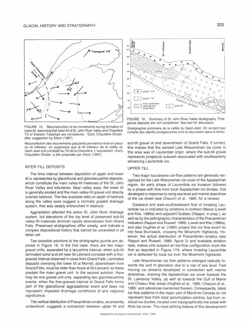
In the light of these considerations, ice movements during the formation period of the Chaudière Till may be reconstructed as depicted in Figure 15.
Correlation with possible synchronous events in northern Maine remains problematic, not in the least because of the diverging views expressed for this area. Genes et al. (1981) and Newman et a/. (1985) claimed the occurrence of a pre-Late Wisconsinan till (St. Francis Till), characterized by east-west fabrics and an absence of Precambrian erratics, at three sites in northern Maine. At none of these sites, however, this till is separated from an overlying younger till by a significant amount of sorted and stratified material. Lowell et al. (1983, 1986) challenge this view, and place the till in the early part of the Late Wisconsinan. They report the presence of about 1 % granites and gneisses (Lowell et al., 1986: 74) in this till and assume deposition by Laurentide ice.
Lowell et al. (1986) do infer, however, at least two earlier till-forming events in the Upper St. John River basin from bore-hole data. Very little is known of these events yet.
Géographie physique et Quaternaire, 43(2), 1989
GLACIAL HISTORY AND STRATIGRAPHY 203
FIGURE 15. Reconstruction of ice movements during formation of lower till, assuming that lower till of St. John River Valley and Chaudière Till of Eastern Towships are correlatives. "Early Chaudière Divide" after suggestion by Elson (1987).
Reconstitution des mouvements glaciaires pendant la mise en place du till inférieur, en supposant que le till inférieur de la vallée du Saint-Jean soit corrélatif au Till de la Chaudière. L'expression « Early Chaudière Divide» a été proposée par Elson (1987).
INTER-TILL DEPOSITS
The time interval between deposition of upper and lower till is represented by glaciofluvial and glaciolacustrine deposits, which constitute the main valley-fill materials of the St. John River Valley and tributaries. Near valley axes, the lower till is generally eroded and the main valley-fill gravel unit directly overlies bedrock. The few available data on depth of bedrock along the valley axes suggest a normally graded drainage system, that was deeply entrenched in bedrock.
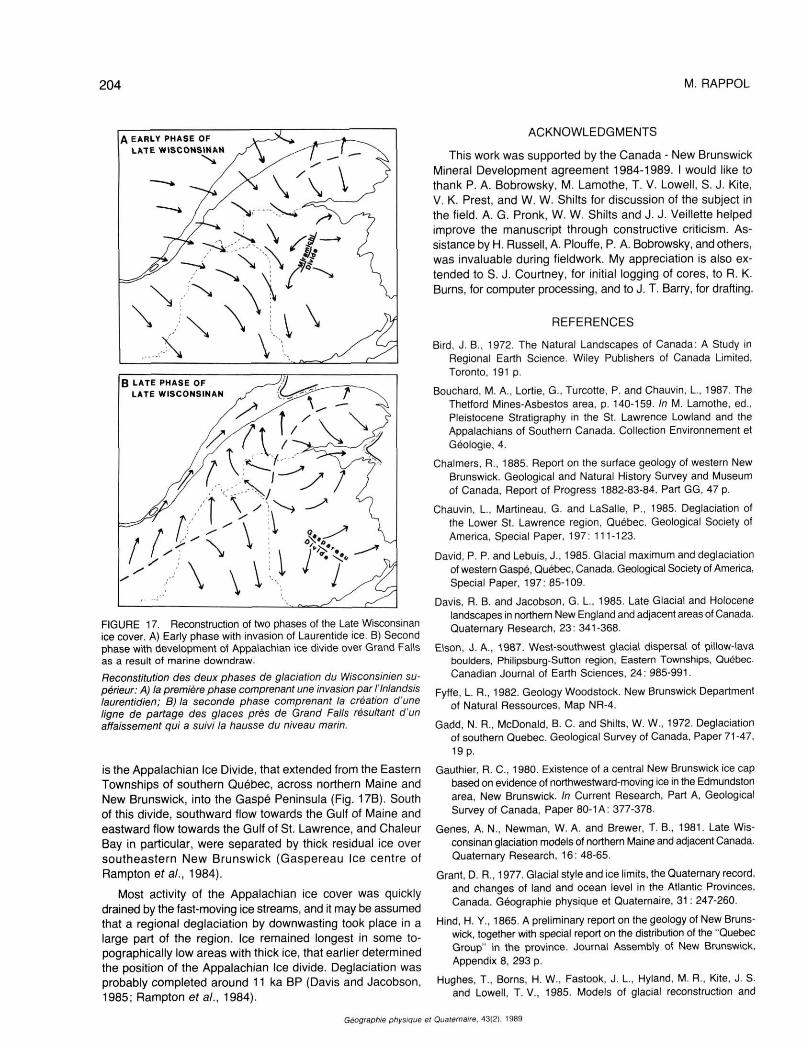
Aggradation affected the entire St. John River drainage system, but elevations of the top level of preserved sub-till valley-fill materials diminish rapidly downstream from Grand Falls. Preserved stratigraphies differ areally, and indicate a complex depositional history that cannot be unravelled in all detail yet.
Two possible solutions to the stratigraphie puzzle are depicted in Figure 16. In the first case, there are two major gravel units, separated by a lacustrine interval, when sub-till laminated sand and silt near St-Léonard correlate with a finegrained interval observed in cores from Grand Falls. Laminated deposits overlying the lower till at Morrell, downstream from Grand Falls, must be older than those at St-Léonard, as these predate the main gravel unit. In the second solution, there may be one gravel unit only, separating two glaciolacustrine events, when the fine-grained interval at Grand Falls forms part of the glaciofluvial aggradational event and does not represent impeded drainage conditions of any regional significance.
The vertical distribution of Precambrian erratics, as presently understood, suggests a connection between upper till and
Géographie physique
FIGURE 16. Summary of St. John River Valley stratigraphy. Postglacial deposits are not considered. See text for discussion.
Stratigraphie sommaire de la vallée du Saint-Jean. On ne tient pas compte des dépôts postglaciaires (voir la discussion dans le texte).
sub-till gravel at and downstream of Grand Falls. If correct, this implies that the earliest Late Wisconsinan ice cover in this area was of Laurentide origin, where the sub-till gravel represents proglacial outwash associated with southeasterly advancing Laurentide ice.
UPPER TILL
Two major successive ice-flow patterns are generally recognized for the Late Wisconsinan ice cover of the Appalachian region. An early phase of Laurentide ice invasion followed by a phase with flow from local Appalachian ice divides, that developed in response to rising sea level and marine downdraw of the ice sheet (see Chauvin et al., 1985, for a review).
Eastward and east-southeastward flow of invading Laurentide ice is indicated by striations in northern Maine (Lowell and Kite, 1986a) and adjacent Québec (Rappol, in prep.), as well as by the pétrographie characteristics of the Precambrian indicators (Rappol and Russell, 1989). Lowell and Kite (1986a), and also Hughes er a/. (1985) project this ice flow event far into New Brunswick, crossing the Miramichi Highlands. However, the actual distribution of Precambrian erratics (see Rappol and Russell, 1989: figure 2) and available striation data, makes one suspect an ice-flow configuration more like that as depicted in Figure 17A, where invading Laurentide ice is deflected by local ice over the Miramichi highlands.
Late Wisconsinan ice flow patterns changed radically towards the end of glaciation due to a rise of sea level. Fast moving ice streams developed in connection with marine downdraw, draining the Appalachian ice cover towards the St. Lawrence Valley, as well as towards the Gulf of Maine and Chaleur Bay areas (Hughes et al., 1985; Chauvin et al., 1985: and references mentioned therein). Consequently, latest ice flow patterns in the major part of Maritime Canada do not represent flow from local accumulation centres, but from residual ice divides, located over topographically low areas with thick ice cover. The most striking feature of this development
e( Quaternaire. 43(2), 1989
204
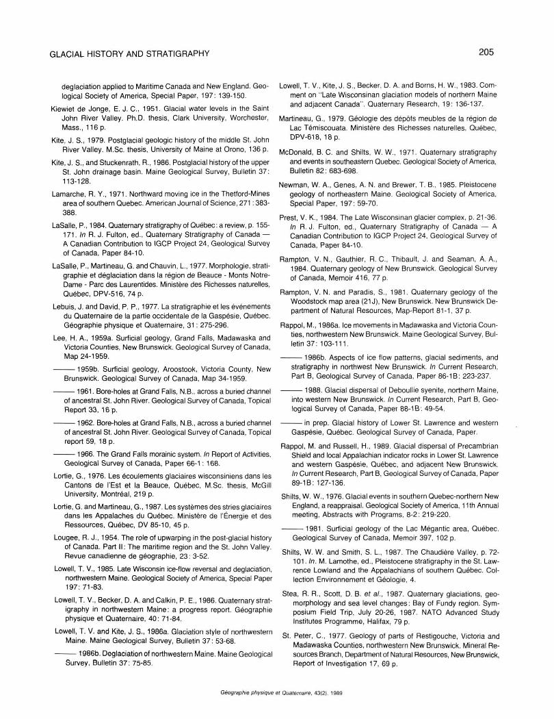
FIGURE 17. Reconstruction of two phases of the Late Wisconsinan ice cover. A) Early phase with invasion of Laurentide ice. B) Second phase with development of Appalachian ice divide over Grand Falls as a result of marine downdraw.
Reconstitution des deux phases de glaciation du Wisconsinien supérieur: A) la première phase comprenant une invasion par l'Inlandsis laurentidien; B) la seconde phase comprenant la création d'une ligne de partage des glaces près de Grand Falls résultant d'un affaissement qui a suivi la hausse du niveau marin.
is the Appalachian Ice Divide, that extended from the Eastern Townships of southern Québec, across northern Maine and New Brunswick, into the Gaspé Peninsula (Fig. 17B). South of this divide, southward flow towards the Gulf of Maine and eastward flow towards the Gulf of St. Lawrence, and Chaleur Bay in particular, were separated by thick residual ice over southeastern New Brunswick (Gaspereau Ice centre of Rampton et al., 1984).
Most activity of the Appalachian ice cover was quickly drained by the fast-moving ice streams, and it may be assumed that a regional déglaciation by downwasting took place in a large part of the region. Ice remained longest in some topographically low areas with thick ice, that earlier determined the position of the Appalachian Ice divide. Déglaciation was probably completed around 11 ka BP (Davis and Jacobson, 1985; Rampton era/. , 1984).
M. RAPPOL
ACKNOWLEDGMENTS
This work was supported by the Canada - New Brunswick Mineral Development agreement 1984-1989. I would like to thank P. A. Bobrowsky, M. Lamothe, T. V. Lowell, S. J. Kite, V. K. Prest, and W. W. Shilts for discussion of the subject in the field. A. G. Pronk, W. W. Shilts and J. J. Veillette helped improve the manuscript through constructive criticism. Assistance by H. Russell, A. Plouffe, P. A. Bobrowsky, and others, was invaluable during fieldwork. My appreciation is also extended to S. J. Courtney, for initial logging of cores, to R. K. Burns, for computer processing, and to J. T. Barry, for drafting.
REFERENCES
Bird, J. B., 1972. The Natural Landscapes of Canada: A Study in Regional Earth Science. Wiley Publishers of Canada Limited, Toronto, 191 p.
Bouchard, M. A., Lortie. G., Turcotte, P. and Chauvin. L., 1987. The Thetford Mines-Asbestos area, p. 140-159. In M. Lamothe, éd., Pleistocene Stratigraphy in the St. Lawrence Lowland and the Appalachians of Southern Canada. Collection Environnement et Géologie, 4.
Chalmers, R., 1885. Report on the surface geology of western New Brunswick. Geological and Natural History Survey and Museum of Canada, Report of Progress 1882-83-84. Part GG, 47 p.
Chauvin, L., Martineau, G. and LaSaIIe, P., 1985. Déglaciation of the Lower St. Lawrence region, Québec. Geological Society of America. Special Paper, 197: 111-123.
David. P. P. and Lebuis, J., 1985. Glacial maximum and déglaciation of western Gaspé, Québec, Canada. Geological Society of America. Special Paper, 197: 85-109.
Davis, R. B. and Jacobson, G. L.. 1985. Late Glacial and Holocene landscapes in northern New England and adjacent areas of Canada. Quaternary Research. 23: 341-368.
Elson, J. A., 1987. West-southwest glacial dispersal of pillow-lava boulders. Philipsburg-Sutton region. Eastern Townships. Québec Canadian Journal of Earth Sciences, 24: 985-991.
Fyffe, L. R., 1982. Geology Woodstock. New Brunswick Department of Natural Ressources, Map NR-4.
Gadd, N. R., McDonald, B. C. and Shilts, W. W., 1972. Déglaciation of southern Quebec. Geological Survey of Canada, Paper 71-47, 19 p.
Gauthier. R. C. 1980. Existence of a central New Brunswick ice cap based on evidence of northwestward-moving ice in the Edmundston area, New Brunswick. In Current Research, Part A, Geological Survey of Canada, Paper 80-1 A: 377-378.
Genes, A. N., Newman, W. A. and Brewer, T. B., 1981. Late Wisconsinan glaciation models of northern Maine and adjacent Canada. Quaternary Research, 16: 48-65.
Grant, D. R.. 1977. Glacial style and ice limits, the Quaternary record, and changes of land and ocean level in the Atlantic Provinces, Canada. Géographie physique et Quaternaire, 31: 247-260.
Hind, H. Y., 1865. A preliminary report on the geology of New Brunswick, together with special report on the distribution of the "Quebec Group" in the province. Journal Assembly of New Brunswick, Appendix 8. 293 p.
Hughes, T., Boms, H. W., Fastook, J. L., Hyland, M. R., Kite, J. S. and Lowell, T. V., 1985. Models of glacial reconstruction and
Géographie physique et Quaternaire. 43(2), 1989
GLACIAL HISTORY AND STRATIGRAPHY 205
déglaciation applied to Maritime Canada and New England. Geological Society of America, Special Paper, 197: 139-150.
Kiewiet de Jonge, E. J. C , 1951. Glacial water levels in the Saint John River Valley. Ph.D. thesis, Clark University, Worchester, Mass., 116 p.
Kite, J. S., 1979. Postglacial geologic history of the middle St. John River Valley. M.Sc. thesis, University of Maine at Orono, 136 p.
Kite, J. S.,andStuckenrath, R., 1986. Postglacial history of the upper St. John drainage basin. Maine Geological Survey, Bulletin 37: 113-128.
Lamarche, R. Y., 1971. Northward moving ice in the Thetford-Mines area of southern Quebec. American Journal of Science, 271:383-388.
LaSaIIe, P., 1984. Quaternary stratigraphy of Québec: a review, p. 155-171. In R. J. Fulton, éd., Quaternary Stratigraphy of Canada — A Canadian Contribution to IGCP Project 24, Geological Survey of Canada, Paper 84-10.
LaSaIIe, P., Martineau, G. and Chauvin, L., 1977. Morphologie, stratigraphie et déglaciation dans la région de Beauce - Monts Notre-Dame - Parc des Laurentides. Ministère des Richesses naturelles, Québec, DPV-516, 74 p.
Lebuis, J. and David, P. P., 1977. La stratigraphie et les événements du Quaternaire de la partie occidentale de la Gaspésie, Québec. Géographie physique et Quaternaire, 31: 275-296.
Lee, H. A., 1959a. Surficial geology, Grand Falls, Madawaska and Victoria Counties, New Brunswick. Geological Survey of Canada, Map 24-1959.
1959b. Surficial geology, Aroostook. Victoria County, New Brunswick. Geological Survey of Canada, Map 34-1959.
1961. Bore-holes at Grand Falls, N.B., across a buried channel of ancestral St. John River. Geological Survey of Canada. Topical Report 33, 16 p.
1962. Bore-holes at Grand Falls. N.B., across a buried channel of ancestral St. John River. Geological Survey of Canada, Topical report 59, 18 p.
1966. The Grand Falls morainic system. In Report of Activities, Geological Survey of Canada, Paper 66-1: 168.
Lortie, G., 1976. Les écoulements glaciaires wisconsiniens dans les Cantons de l'Est et la Beauce, Québec, M.Sc. thesis, McGiII University, Montréal, 219 p.
Lortie, G. and Martineau, G., 1987. Les systèmes des stries glaciaires dans les Appalaches du Québec. Ministère de l'Énergie et des Ressources, Québec, DV 85-10, 45 p.
Lougee, R. J., 1954. The role of upwarping in the post-glacial history of Canada. Part II: The maritime region and the St. John Valley. Revue canadienne de géographie, 23: 3-52.
Lowell, T. V., 1985. Late Wisconsin ice-flow reversal and déglaciation, northwestern Maine. Geological Society of America, Special Paper 197: 71-83.
Lowell, T. V., Becker, D. A. and Calkin, P. E., 1986. Quaternary stratigraphy in northwestern Maine: a progress report. Géographie physique et Quaternaire, 40: 71-84.
Lowell, T. V. and Kite, J. S., 1986a. Glaciation style of northwestern Maine. Maine Geological Survey, Bulletin 37: 53-68.
1986b. Déglaciation of northwestern Maine. Maine Geological Survey, Bulletin 37: 75-85.
Lowell, T. V., Kite, J. S., Becker, D. A. and Borns, H. W., 1983. Comment on "Late Wisconsinan glaciation models of northern Maine and adjacent Canada". Quaternary Research, 19: 136-137.
Martineau, G., 1979. Géologie des dépôts meubles de la région de Lac Témiscouata. Ministère des Richesses naturelles, Québec. DPV-618, 18 p.
McDonald, B. C. and Shilts, W. W., 1971. Quaternary stratigraphy and events in southeastern Quebec. Geological Society of America, Bulletin 82: 683-698.
Newman, W. A., Genes, A. N. and Brewer, T. B., 1985. Pleistocene geology of northeastern Maine. Geological Society of America, Special Paper, 197: 59-70.
Prest, V. K., 1984. The Late Wisconsinan glacier complex, p. 21-36. In R.J. Fulton, éd., Quaternary Stratigraphy of Canada — A Canadian Contribution to IGCP Project 24. Geological Survey of Canada, Paper 84-10.
Rampton, V. N., Gauthier. R. C, Thibault, J. and Seaman, A. A., 1984. Quaternary geology of New Brunswick. Geological Survey of Canada, Memoir 416, 77 p.
Rampton, V. N. and Paradis, S., 1981. Quaternary geology of the Woodstock map area (21 J), New Brunswick. New Brunswick Department of Natural Resources, Map-Report 81-1. 37 p.
Rappol, M., 1986a. Ice movements in Madawaska and Victoria Counties, northwestern New Brunswick. Maine Geological Survey, Bulletin 37: 103-111.
1986b. Aspects of ice flow patterns, glacial sediments, and stratigraphy in northwest New Brunswick. In Current Research, Part B, Geological Survey of Canada, Paper 86-1B: 223-237.
1988. Glacial dispersal of Deboullie syenite, northern Maine, into western New Brunswick. In Current Research, Part B, Geological Survey of Canada, Paper 88-1B: 49-54.
in prep. Glacial history of Lower St. Lawrence and western Gaspésie, Québec. Geological Survey of Canada, Paper.
Rappol, M. and Russell, H., 1989. Glacial dispersal of Precambrian Shield and local Appalachian indicator rocks in Lower St. Lawrence and western Gaspésie. Québec, and adjacent New Brunswick. In Current Research, Part B, Geological Survey of Canada, Paper 89-1B: 127-136.
Shilts, W. W., 1976. Glacial events in southern Quebec-northern New England, a reappraisal. Geological Society of America, 11th Annual meeting, Abstracts with Programs, 8-2: 219-220.
1981. Surficial geology of the Lac Mégantic area, Québec. Geological Survey of Canada, Memoir 397, 102 p.
Shilts, W. W. and Smith, S. L., 1987. The Chaudière Valley, p. 72-101. In. M. Lamothe, éd., Pleistocene stratigraphy in the St. Lawrence Lowland and the Appalachians of southern Québec. Collection Environnement et Géologie, 4.
Stea, R. R., Scott, D. B. et al., 1987. Quaternary glaciations, geo-morphology and sea level changes: Bay of Fundy region. Symposium Field Trip, July 20-26, 1987. NATO Advanced Study Institutes Programme, Halifax, 79 p.
St. Peter, C, 1977. Geology of parts of Restigouche, Victoria and Madawaska Counties, northwestern New Brunswick. Mineral Resources Branch, Department of Natural Resources, New Brunswick, Report of Investigation 17, 69 p.
Géographie physique el Quaternaire, 43(2), 1989
206 M. RAPPOL
Thibault, J., 1980. Granular aggregate resources, Saint-André (NTS 210/4), Aroostook (NTS 21J/13), New Brunswick. Department of Natural Resources, New Brunswick, Open File Report 80-6.36 p.
Thomas, R. H., 1977. Calving bay dynamics and ice sheet retreat up the St. Lawrence Valley system. Géographie physique et Quaternaire, 3 1 : 347-356.
Thompson, W. B. and Borns, H. W., 1985. Suriicial geologic map of Maine. Maine Geological Survey, Department of Conservation.
Young, G. A., 1913. Grand Falls, St. John River. Geological Survey, Guidebook No. 1, Excursion in eastern Canada and the Maritime Provinces, Part II: 399-407.
Géographie physique et Quaternaire. 43(2). 1989