Embed Size (px)
Citation preview
GIST 4302/5302: Spatial Analysis and ModelingLecture 1: Overview
Guofeng Caowww.myweb.ttu.edu/gucao
Department of Geosciences
Texas Tech University
Spring 2014
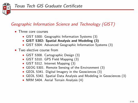
Texas Tech GIS Graduate Certificate
Geographic Information Science and Technology (GIST)
• Three core courses• GIST 5300: Geographic Information Systems (3)• GIST 5302: Spatial Analysis and Modeling (3)• GIST 5304: Advanced Geographic Information Systems (3)
• Two elective course from• GIST 5308. Cartographic Design (3)• GIST 5310. GPS Field Mapping (3)• GIST 5312. Internet Mapping (3)• GEOG 5301. Remote Sensing of the Environment (3)• GEOL 5341. Digital Imagery in the Geosciences (3)• GEOL 5342. Spatial Data Analysis and Modeling in Geosciences (3)• NRM 5404. Aerial Terrain Analysis (4)
2/18
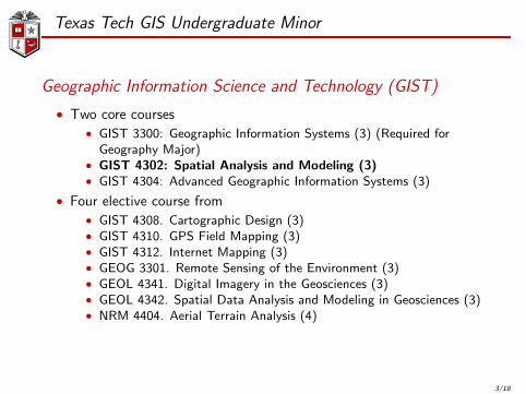
Texas Tech GIS Undergraduate Minor
Geographic Information Science and Technology (GIST)
• Two core courses• GIST 3300: Geographic Information Systems (3) (Required for
Geography Major)• GIST 4302: Spatial Analysis and Modeling (3)• GIST 4304: Advanced Geographic Information Systems (3)
• Four elective course from• GIST 4308. Cartographic Design (3)• GIST 4310. GPS Field Mapping (3)• GIST 4312. Internet Mapping (3)• GEOG 3301. Remote Sensing of the Environment (3)• GEOL 4341. Digital Imagery in the Geosciences (3)• GEOL 4342. Spatial Data Analysis and Modeling in Geosciences (3)• NRM 4404. Aerial Terrain Analysis (4)
3/18
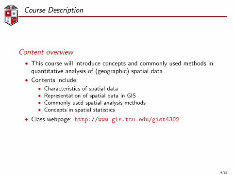
Course Description
Content overview
• This course will introduce concepts and commonly used methods inquantitative analysis of (geographic) spatial data
• Contents include:• Characteristics of spatial data• Representation of spatial data in GIS• Commonly used spatial analysis methods• Concepts in spatial statistics
• Class webpage: http://www.gis.ttu.edu/gist4302
4/18
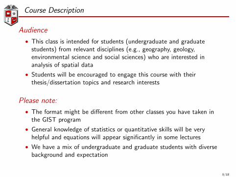
Course Description
Audience
• This class is intended for students (undergraduate and graduatestudents) from relevant disciplines (e.g., geography, geology,environmental science and social sciences) who are interested inanalysis of spatial data
• Students will be encouraged to engage this course with theirthesis/dissertation topics and research interests
Please note:
• The format might be different from other classes you have taken inthe GIST program
• General knowledge of statistics or quantitative skills will be veryhelpful and equations will appear significantly in some lectures
• We have a mix of undergraduate and graduate students with diversebackground and expectation
5/18
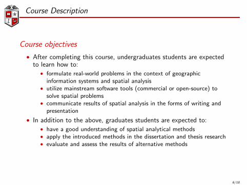
Course Description
Course objectives
• After completing this course, undergraduates students are expectedto learn how to:
• formulate real-world problems in the context of geographicinformation systems and spatial analysis
• utilize mainstream software tools (commercial or open-source) tosolve spatial problems
• communicate results of spatial analysis in the forms of writing andpresentation
• In addition to the above, graduates students are expected to:• have a good understanding of spatial analytical methods• apply the introduced methods in the dissertation and thesis research• evaluate and assess the results of alternative methods
6/18
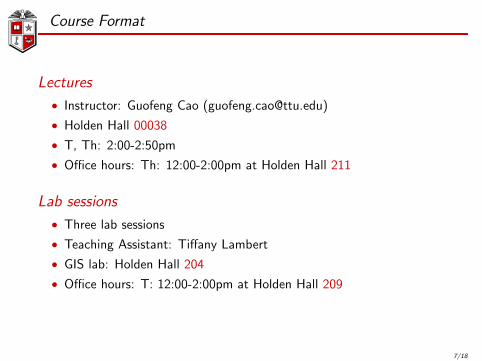
Course Format
Lectures
• Instructor: Guofeng Cao ([email protected])
• Holden Hall 00038
• T, Th: 2:00-2:50pm
• Office hours: Th: 12:00-2:00pm at Holden Hall 211
Lab sessions
• Three lab sessions
• Teaching Assistant: Tiffany Lambert
• GIS lab: Holden Hall 204
• Office hours: T: 12:00-2:00pm at Holden Hall 209
7/18

Lab Assignments
Lab assignments
• ∼ 3 hours each week
• Multiple software will be utilized:• ArcGIS• Open GeoDa• R or Matlab (Optional)
8/18

Final Project
Final project
• The project could be used as a setting for your thesis anddissertation topics, other course topics or research interests
• Group collaboration is encouraged, but for each group, no more thantwo graduates are allowed
• Start to think of the project ideas early and communicate with theinstructor and TA for comments
• Project presentation: PechaKucha stylehttp: // en. wikipedia. org/ wiki/ PechaKucha
• Project report: no more than 8 pages with single space and size 12font
• Geosciences Research Day (http://www.depts.ttu.edu/gesc/Studentresearchday_2014.php)
9/18
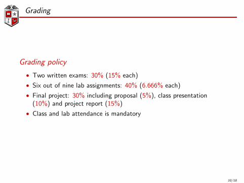
Grading
Grading policy
• Two written exams: 30% (15% each)
• Six out of nine lab assignments: 40% (6.666% each)
• Final project: 30% including proposal (5%), class presentation(10%) and project report (15%)
• Class and lab attendance is mandatory
10/18
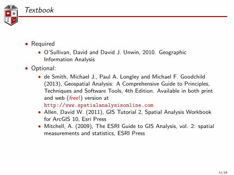
Textbook
• Required• O’Sullivan, David and David J. Unwin, 2010. Geographic
Information Analysis
• Optional:• de Smith, Michael J., Paul A. Longley and Michael F. Goodchild
(2013), Geospatial Analysis: A Comprehensive Guide to Principles,Techniques and Software Tools, 4th Edition. Available in both printand web (free!) version athttp://www.spatialanalysisonline.com
• Allen, David W. (2011), GIS Tutorial 2, Spatial Analysis Workbookfor ArcGIS 10, Esri Press
• Mitchell, A. (2009), The ESRI Guide to GIS Analysis, vol. 2: spatialmeasurements and statistics, ESRI Press
11/18
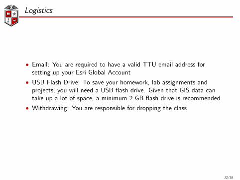
Logistics
• Email: You are required to have a valid TTU email address forsetting up your Esri Global Account
• USB Flash Drive: To save your homework, lab assignments andprojects, you will need a USB flash drive. Given that GIS data cantake up a lot of space, a minimum 2 GB flash drive is recommended
• Withdrawing: You are responsible for dropping the class
12/18
Quiz
Please try to answer the following questions
13/18
Quiz
1. Which one of the following best approximate the radius of theEarth?
(a) 4356 km(b) 6356 km(c) 8356 km
2. Which one of the following best approximate the latitude ofLubbock or this classroom?
(a) 33 ◦
(b) 43 ◦
(c) 53 ◦
3. How far does one degree of latitude approximate on the ground?
(a) 10 km(b) 110 km(c) 1100 km
4. GPS device on my smart phone gave me the reading(47.640120461583138,−122.12971039116383). Does it make sense?
14/18
Quiz
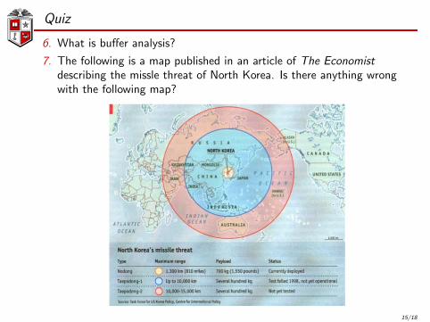
6. What is buffer analysis?
7. The following is a map published in an article of The Economistdescribing the missle threat of North Korea. Is there anything wrongwith the following map?
15/18
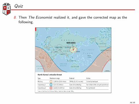
Quiz
8. Then The Economist realized it, and gave the corrected map as thefollowing.
16/18
Quiz
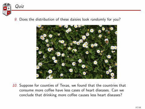
9. Does the distribution of these daisies look randomly for you?
10. Suppose for counties of Texas, we found that the countries thatconsume more coffee have less cases of heart diseases. Can weconclude that drinking more coffee causes less heart diseases?
17/18
Thank you
Questions/comments?
18/18