Embed Size (px)
Citation preview

GIS Data Production
and
Editing Pathway
Table of Contents
ArcGIS Desktop II: Tools and Functionality _______________________________________ 3
ArcGIS Desktop III: GIS Workflows and Analysis __________________________________________ 6
Building Geodatabases ______________________________________________________________ 8
Creating and Maintaining Metadata Using ArcGIS Desktop ________________________________ 10
Data Production and Editing Techniques ______________________________________________ 12
Creating and Editing Parcels with ArcGIS Desktop _______________________________________ 17
Creating and Integrating Data for Natural Resource Applications ___________________________ 19
Geoprocessing Using ModelBuilder ___________________________________________________ 21
Introduction to the Multiuser Geodatabase ____________________________________________ 22
Linear Referencing with ArcGIS Desktop _______________________________________________ 25
QA/QC for GIS Data _______________________________________________________________ 27
ArcGIS Desktop II: Tools and Functionality 3 days (24 hours) Authored by ESRI
Overview
This course is part of the ArcGIS Desktop 9.3 Foundational Training Curriculum. The ArcGIS 9.2
version of this course was titled Introduction to ArcGIS I.
ArcGIS Desktop software is an integrated system that includes all the tools needed to get the
most out of a GIS. This course teaches the range of functionality available in the software and
the essential tools for visualizing, creating, managing, and analyzing geographic data. The
hands-on course exercises emphasize practice with ArcMap and ArcCatalog (the primary
applications included with ArcGIS Desktop software) to perform common GIS tasks and
workflows. The tools for creating and managing geographic data, displaying data on maps in
different ways, and combining and analyzing data to discover patterns and relationships are
highlighted, and you learn how ArcGIS Desktop provides a complete GIS software solution. By
the end of the course, you will be prepared to start working with the software on your own.
Who Should Attend
This course is designed for those with an education in or workplace experience with GIS but no
ArcGIS software experience. This course assumes knowledge of basic GIS concepts. This course
teaches the skills and knowledge needed to take other ArcGIS courses, including ArcGIS Desktop
III: GIS Workflows and Analysis
Goals
.
Those who complete this course will be able to
List common GIS tasks and identify which ArcGIS Desktop application is used for each
task.
Understand what the geodatabase offers for GIS data storage.
Create and edit geodatabase features.
Control the appearance and display of data layers in ArcMap.
Classify and symbolize map data.
Label map features.
Change the coordinate system and map projection used to display a dataset.
Access feature information in tables and control table display properties.
Query and analyze GIS data.
Create presentation-quality maps and graphs.
Topics Covered Table of Contents [PDF 25kb]
Investigating geographic data: How geographic data is stored; Vector and raster data;
Geodatabase basics and advantages; Shapefiles; Coverages; CAD data; Managing data in
ArcCatalog; Displaying data in ArcMap; ArcMap basics; Data and layers.
Managing map layers: Zooming to layers; Bookmarks; Display windows; Scale ranges;
Group layers; Selection layers; Layer files; Creating hyperlinks.
Symbolizing categorical data: Symbology; Choosing symbology; Types of symbols
(marker, line, fill); Creating symbols.
Symbolizing quantitative data: Symbology options (graduated colors, graduated symbols,
proportional symbols, dot density, charts); Classification methods (Natural Breaks, Equal
Interval, Quantile, Manual); Excluding data from a classification; Rendering raster data.
Labeling map features: Label placement for different feature types (points, lines,
polygons); Label symbology; Controlling label display using scale range and SQL query;
Label classes; Label expressions; Label ranks and weights; What is annotation?;
Geodatabase annotation; Map annotation.
Using coordinate systems and map projections: What is a coordinate system?;
Geographic coordinate systems; Datums; Projected coordinate systems; Map projections;
Feature classes and coordinate systems; Data frames and coordinate systems;
Geographic transformations; Working with an unknown coordinate system; Projecting
data; Defining a projection.
Making a map layout: Working in layout view; Tools for arranging map elements; Data
frame properties for layouts; Adding legends, scale bars, and other map elements;
Exporting maps; Working with map templates.
Managing tables: Table structure; Layer attribute tables; Nonspatial tables; Getting
information from tables; Field properties; Table appearance; Creating graphs and
reports; Connecting tables using joins and relates; Cardinality.
Editing features and attributes: Reasons to edit data; Working with the Editor toolbar;
Edit sketches; Common editing tools; Edit tasks; Snapping to features while editing;
Editing attributes; Calculating values for geometry fields; Working with coincident
geometry in a map topology; Typical editing workflow.
Creating geodatabases and feature classes: Types of geodatabases; Geodatabase
organization; Feature class organization; Feature class properties and attributes;
Metadata; Creating, viewing, and editing metadata; Importing and exporting metadata;
Creating features in a new feature class.
Getting locations from attributes: Adding x,y coordinate data; Finding places and
addresses; Finding routes and nearby places; Geocoding; Geocoding components
(address table, address locator, reference data); Address matching overview; Geocoding
workflow; Reference data sources.
Solving spatial problems with query and analysis: GIS analysis basics; Typical analysis
workflow; Common analysis operations (attribute and spatial queries, clipping data from
layers, buffering features, overlaying features); Overview of geoprocessing; Analysis
results.
Customizing ArcGIS Desktop: Why customize the interface?; Customize dialog box;
Locating commands; Adding new toolbars, commands, and menus; Saving
customizations; Saving to a template; Storing templates.
Prerequisites
Students should have completed ArcGIS Desktop I: Getting Started with GIS or Getting Started
with GIS
Software Used in Course
or have equivalent knowledge.
This course is designed to work with the following software:
ArcGIS Desktop* Version
ArcEditor 9.3
ArcInfo 9.3
ArcView 9.3
*Only one of the listed licenses will be used in the classroom.
ArcGIS Desktop III: GIS Workflows and Analysis 2 days (16 hours) Authored by ESRI
Overview
This course is part of the ArcGIS Desktop 9.3 Foundational Training Curriculum. The ArcGIS 9.2 version of this course was titled Introduction to ArcGIS II.
Understanding how and when to apply ArcGIS tools and functions is the key to creating an
efficient GIS workflow. Building on the skills and knowledge taught in ArcGIS Desktop II: Tools
and Functionality, this course shows how to apply ArcGIS tools in a workflow context with a focus
on working with data stored in a geodatabase and performing geoprocessing and analysis. In the
course exercises, you organize and edit data stored in a geodatabase, prepare data for analysis,
create and edit geoprocessing models using ModelBuilder, and work through a challenging
analysis project.
Who Should Attend
This course is designed for experienced ArcGIS users who want to learn more about the ArcGIS
tools for creating and editing data and GIS analysis.
Goals
Those completing this course will be able to
Add data from different sources to a geodatabase.
Work with subtypes to edit data.
Edit and validate feature geometry and attributes using geodatabase topology.
Run analysis tools using dialog boxes and models.
Build a complex model using ModelBuilder.
Topics Covered Table of Contents [PDF 21kb]
Getting data into the geodatabase: Advantages of migrating data to the geodatabase;
File and personal geodatabases; Loading and importing data; Data sources available for
conversion; ArcToolbox conversion tools; Importing and exporting data in ArcCatalog;
Importing and exporting data using XML; Copying and pasting data between
geodatabases; Batch and single conversions; Loading data into existing feature classes
using the Simple Data Loader; Displaying x,y coordinate data from a table; Accessing
tabular data using an OLE DB connection; Adding data from a GIS server; Working with
map projections and datums.
Geodatabase behavior: What is behavior?; Advantages of using behaviors; Default
values; Subtypes; Domains; Geodatabase topology.
Editing GIS data: Creating new data (digitizing, copying and pasting features, Editor
menu commands); Constructing an edit sketch using constraints (direction, length,
parallel); Creating adjacent polygons using the Auto-Complete Polygon task; Modifying
existing features; Reshaping existing features and boundaries; Exploding multipart
features; Editing using domains, subtypes, and topology.
Aligning spatial data: Common data alignment problems; Georeferencing CAD data;
Matching layer boundaries; Transformation; Rubber sheeting; RMS error.
Managing geoprocessing tools and settings: Types of toolboxes and how they are stored;
Types of tools (system tools, models, scripts); Locating tools in ArcToolbox; Executing
tools; Tool parameters; Parameter error detection; Environment settings; Tool layers;
Geoprocessing results.
Analyzing GIS data: Review of common analysis tools (Buffer, Clip, Intersect, Select,
Union); Working with feature proximity tools (Near, Spatial Join, Multiple Ring Buffer,
Create Thiessen Polygons); Analyzing tabular data; Creating a raster subset; Analysis
options outside of core ArcGIS Desktop; Typical analysis workflow.
Using ModelBuilder for analysis: Working with ModelBuilder; Creating and designing
models; Model elements (tools and variables); Setting general model properties; Setting
model parameters; Environment settings; Intermediate data; Running and
troubleshooting a model; Creating model documentation.
GIS analysis projects: Real-world GIS analysis projects (Find the best site for a new
shelter, Find the mileage of flooded roads); The analytical process for each project.
Prerequisites
Students should have completed ArcGIS Desktop II: Tools and Functionality or Learning ArcGIS
Desktop
Software Used in Course
or have equivalent knowledge.
This course is designed to work with the following software:
ArcGIS Desktop Version
ArcInfo 9.3
Building Geodatabases 3 days (24 hours) Authored by ESRI
Overview
This course provides an overview of the structure and capabilities of the geodatabase. You learn
how to create a geodatabase, migrate existing GIS data to a geodatabase, and edit and maintain
data stored in a geodatabase. The course covers some advanced geodatabase topics including
how to build a geodatabase topology; maintain data integrity using subtypes, attribute domains,
and relationship classes; and create a geodatabase schema. In course exercises, you work with
the file geodatabase and learn how to migrate personal geodatabase data to a file geodatabase
and create various geodatabase components.
Who Should Attend
This course is designed for experienced ArcGIS users who want to store data in a geodatabase
and take advantage of advanced geodatabase functionality. Data managers will find this course
of particular benefit. Those who will be working with a multiuser geodatabase may also wish to
enroll in Introduction to the Multiuser Geodatabase
Goals
, which pairs well with this course.
Those completing this course will be able to
Understand the geodatabase structure.
Explain advantages of a file geodatabase.
Understand advantages of geodatabase validation rules.
Load vector and raster data into a geodatabase.
Create and apply attribute domains, subtypes, and relationship classes.
Edit data using attribute domains, subtypes, and relationship classes.
Create and edit geodatabase annotation.
Create geodatabase topology and apply topology rules.
Edit topological data.
Perform geometric network editing and tracing.
Topics Covered Table of Contents [PDF 24kb]
Introduction to the geodatabase: Advantages of the geodatabase; Focusing on the file
geodatabase; Overview of elements within the geodatabase; Geodatabase tables in a
database management system (DBMS).
Attribute validation rules: Subtypes and domains; Creating subtypes; Editing subtypes in
ArcMap; Creating domains; Editing with domains in ArcMap; Coded value versus. range
domains; Subtypes and relationship rules.
Relationship classes: Creating relationship classes; Setting relationship class properties;
Using relationships in ArcMap; Relationship rules; Validation; Simple versus. composite
relationships.
Annotation: Creating, editing, and managing annotation features in the geodatabase.
Geodatabase topology: Topology management in the geodatabase; Building a topology;
Setting the properties of a topology; Setting appropriate topological rules; Fixing
topological errors; Editing topological data.
Geometric networks: Creating and editing geometric networks; Performing analysis;
Setting and using connectivity rules.
Building geodatabase schema: Different ways to define geodatabase schema; Creating
tables, feature classes, and feature datasets.
XML data interchange: Understanding XML schemas of the geodatabase; Exporting the
contents of a geodatabase to XML; Importing an XML file into a geodatabase.
Vector data in the geodatabase: Loading data from shapefiles, CAD files, coverages, and
Excel spreadsheets; Using ArcGIS vector data loading tools.
Raster data in the geodatabase: Storing raster datasets, raster catalogs, and raster
attributes in the geodatabase.
Prerequisites
Students should have completed ArcGIS Desktop II: Tools and Functionality or Learning ArcGIS
Desktop
Software Used in Course
or have equivalent knowledge.
This course is designed to work with the following software:
ArcGIS Desktop* Version
ArcEditor 9.3
ArcInfo 9.3
*Only one of the listed licenses will be used in the classroom.
Creating and Maintaining Metadata Using ArcGIS Desktop 3 modules (9 hours) Authored by ESRI
Overview
Metadata, the key information that documents a dataset, has emerged as a powerful tool for
safeguarding an organization's investment in spatial data. Documenting datasets allows people
to efficiently find them, evaluate their usefulness for a particular project, and share them with
others. This course shows how metadata supports efficient management and use of spatial data
and teaches practical strategies for creating and maintaining metadata using ArcGIS Desktop
software. Students learn how to write proper metadata using tools in ArcCatalog and how to
automate metadata workflows using templates.
Who Should Attend
This course is designed for experienced ArcGIS users who work with, create, edit, or manage
spatial data.
Goals
Those completing this course will be able to
Describe the benefits of creating and maintaining metadata.
Explain the advantages of adhering to a metadata standard.
Implement an appropriate metadata standard.
Search metadata to find datasets.
Evaluate datasets using metadata.
Plan metadata content.
Write proper metadata.
Create templates and use sample code to streamline metadata production.
Identify various ways to share metadata.
Topics Covered
Getting Started with Metadata: The value of metadata; Finding data and applying
metadata standards
Creating and Editing Metadata: Creating metadata; Planning metadata content
Planning a Metadata Workflow: Developing a metadata workflow; Sharing your metadata
Prerequisites
Students should have completed Learning ArcGIS Desktop
Software Required
or have equivalent knowledge.
To complete course exercises, you need the following software:
ArcGIS Desktop* Version
ArcView 9.1, 9.2 or 9.3
ArcEditor 9.1, 9.2 or 9.3
ArcInfo 9.1, 9.2 or 9.3
*Only one product in this category is required.
Data Production and Editing Techniques 3 days (24 hours) Authored by ESRI
Overview
Intended for the GIS technician, this course teaches the software skills and concepts needed to
automate and maintain feature data in an ArcGIS geodatabase. Using the tools available with
ArcGIS software, you learn techniques for data preparation, conversion, and editing. You also
learn how topology and other geodatabase validation rules help maintain data integrity as part of
an editing workflow. This course teaches practical methods for working with spatial and attribute
data with an emphasis on data stored in the geodatabase. Each day concludes with a project,
allowing you to apply these techniques on your own.
Who Should Attend
This course is designed for experienced ArcGIS users who need to create and update data. GIS
technicians responsible for maintaining their organizations' geographic data holdings will find the
course of particular benefit. Those who are interested in automating data creation and
maintenance tasks using scripts may also wish to enroll in Geoprocessing Using ModelBuilder
Goals
,
which pairs well with this course.
Those completing this course will be able to
Convert data stored in different formats to the geodatabase format.
Use a data workflow and editing process in ArcGIS.
Solve common coordinate system problems.
Create and modify features using ArcMap sketch and edit tools.
Create and edit feature attributes and tables.
Maintain data integrity with geodatabase rules.
Create metadata to document datasets.
Topics Covered Table of Contents [PDF 45kb]
Importing and loading data: Geodatabase data loading workflow; Evaluating source data;
Preparing source data; Creating geodatabase tables and feature classes; Data loading
tools; Post-loading workflow; Setting metadata.
Correcting coordinate systems: Coordinate systems overview; Coordinate system
properties; Geographic (datum) transformations; Coordinate system problems and
solutions; Projection on-the-fly in ArcMap; Setting coordinate system properties in
ArcMap; Projection and coordinate system transformation tools; Data integration tools.
Spatially adjusting features: Correcting an unknown coordinate system; Spatial
Adjustment tools for features; Adding links; Adjustment methods; Integrating new
features; Georeferencing rasters (summary).
Data loading project: Students independently use the skills learned in the previous
lessons to correct, load and integrate several data layers into a geodatabase.
Creating features visually: Feature creation techniques overview; Digitizing workflow;
Feature geometry concepts; Board vs. heads-up digitizing; Discrete vs. Spaghetti style
digitizing; Creating polygons from lines and points; Setting the edit environments.
Creating features geometrically: Sketch tools and context menus; Feature construction;
Editing environments; Choosing a sketch tool; Sketch construction constraints; Sketch
construction options; Creating straight and curved segments; Centerline construction;
Parallel construction; Perpendicular construction; Curve construction; Distance-Distance
construction.
Editing features: Finding geometry errors; Handling overlapping polygons; Merging and
exploding multipart features; Creating and editing multipart features; Reshaping
features; Merging features; Splitting features; Tracing features; Editing tips.
Editing with map topology: Coincident and shared geometry; Topology edges and nodes;
Map topology concepts; Map topology workflow; Moving nodes; Moving edges; Reshaping
edges; Modifying edges; Splitting edges; Digitizing and constructing features in a map
topology; Excluding features; Clipping polygons with a line buffer.
Feature creation and editing project: Students independently use the skills learned in the
previous lessons to update multiple feature classes with new features.
Creating attributes: Feature attributes and sources; Adding during or after feature
creation; Attributes editor and tables; Using defaults, subtypes, and domains; Using the
Field Calculator; Transfer from a joined table, from a feature, and from a spatially joined
feature class.
Editing attributes and tables: Finding attribute errors with Validate, Summarize, queries,
and visual inspection; Attribute editing tools; Using SQL in selections; Making global edits
with the Field Calculator and Find & Replace; Editing attributes with Visual Basic; Adding
and deleting fields; Exporting records and fields; Creating and using an attribute domain;
Creating and using a relationship class with rules.
Editing with geodatabase topology: Geodatabase topology concepts and workflow;
Creating a topology with ranks and rules; Setting the cluster tolerance; Validating a
topology; Errors and dirty areas; Using the Error Inspector; Fixing various topology
errors.
Data maintenance project: Students independently use the skills learned in the previous
lessons to correct attribute and topology errors in a new subdivision.
Prerequisites
Students should have completed ArcGIS Desktop II: Tools and Functionality or Learning ArcGIS
Desktop
Software Used in Course
or have equivalent knowledge.
This course is designed to work with the following software:
ArcGIS Desktop* Version
ArcEditor 9.3
ArcInfo 9.3
*Only one of the listed licenses will be used in the classroom.
Geoprocessing with ArcGIS Desktop 5 modules (15 hours) Authored by ESRI
Overview
Requires ArcGIS 9.2 or 9.3.
Geoprocessing is a primary function of a GIS. ArcGIS Desktop software provides hundreds of
tools for processing geographic data as well as ModelBuilder, a graphical environment for
visualizing and executing workflows. This five-module course teaches practical strategies for
using the ArcGIS geoprocessing framework to accomplish GIS workflows. Students work with
geoprocessing tools to create and organize workspaces, prepare data for analysis, and perform
GIS analysis tasks, then learn how to streamline processes using models and scripts. Students
also learn how to create custom geoprocessing tools and document custom tools, scripts, and
models. This course provides a solid foundation in the ArcGIS Desktop geoprocessing framework
and emphasizes hands-on practice through software exercises.
Who Should Attend
This course is designed for experienced ArcGIS Desktop users who want to use geoprocessing
tools and models in their GIS projects.
Goals
Those completing this course will be able to
Set up and modify the geoprocessing environment.
Find and run the appropriate geoprocessing tools for a variety of tasks.
Prepare data for analysis.
Use geoprocessing tools to create, modify, and analyze spatial data.
Create custom geoprocessing tools and models.
Model workflows using geoprocessing tools and ModelBuilder.
Automate and refine geoprocesses using scripting.
Document geoprocessing methods for reusability and sharing.
Topics Covered
Getting Started with Geoprocessing: What is geoprocessing?; Geoprocessing with ArcGIS
Data Preparation: About the lynx project; Setting up your work environment; Preparing
your data for analysis
Data Analysis: Modeling your workflow; Refining your analysis
Getting More Out of Geoprocessing: Introduction to scripting; Using scripts in models
Documenting Your Work: Documentation for geoprocessing; Sharing your work
Prerequisites
Students should have completed ArcGIS Desktop II: Tools and Functionality or Learning ArcGIS
Desktop
Software Required
.
To complete course exercises, you need the following software:
ArcGIS Desktop* Version
ArcView 9.2 or 9.3
ArcEditor 9.2 or 9.3
ArcInfo 9.2 or 9.3
*Only one product in this category is required.
Other Version
PythonWin 2.4 or 2.5
Creating and Editing Parcels with ArcGIS Desktop 2 days (16 hours) Authored by ESRI
Overview
This course provides an introduction to storing and maintaining cadastral data in a geodatabase
using COGO (Coordinate Geometry) tools in ArcGIS Desktop. You learn basic concepts of the
geodatabase data model and a process for editing parcels. In course exercises, you practice
displaying, symbolizing, and editing parcel data as well as entering subdivisions into existing
parcels. The course also teaches how to create and modify tax map annotation.
Who Should Attend
This course is designed for tax mapping professionals and GIS technicians who want to maintain
an accurate and up-to-date geographic representation of local cadastral data.
Goals
Those completing this course will be able to
Understand the structure and capabilities of a geodatabase.
Symbolize cadastral data.
Create layer files.
Set up the ArcMap editing environment.
Create new features using COGO bearing and distance measurements.
Adjust traverses to fit into an existing parcel framework.
Use geodatabase topology to ensure data integrity.
Use many of the ArcMap editing and drawing tools.
Create and modify annotation including lot dimensions.
Enter subdivisions.
Topics Covered Table of Contents [PDF 22kb]
Introduction to the geodatabase: Data storage options; Geodatabase structures and
permissions; Multiuser vs. personal geodatabase.
Symbology and navigation: Unique values; Single symbol; Cartographic symbols; Finding
features; Selecting features.
The editing environment: Edit sessions; Snapping; Units; Task/Target; Selectable layers;
Coincident features; Topology.
The process of subdividing parcels: Entering lines; Adjusting lines; Creating polygons;
Creating annotation.
Entering closed traverses: From plats; From deeds.
Tools overview: Copy features tool; Fillet tool; Extend tool; Trim tool; Proportion tool;
Topology error inspector.
Working with geodatabase annotation: Feature-linked annotation; Standard annotation.
Practice entering a subdivision: COGO; Georeferencing plats; Heads-up drawing;
Importing from CAD.
Prerequisites
Students should have completed ArcGIS Desktop II: Tools and Functionality or Learning ArcGIS
Desktop
Software Used in Course
or have equivalent experience. They should also be familiar with tax mapping
terminology and practices.
This course is designed to work with the following software:
ArcGIS Desktop* Version
ArcEditor 9.3
ArcInfo 9.3
*Only one of the listed licenses will be used in the classroom.
Creating and Integrating Data for Natural Resource Applications 4 modules (12 hours) Authored by ESRI
Overview
Requires ArcGIS 9.2 or 9.3.
Frequently, the natural resource data needed for a project (such as vegetation, species locations,
or watersheds) does not exist. Or, the data may exist but significant manipulation is required
before it can be displayed and used for analysis in a GIS. This four-module course teaches
methods for acquiring, evaluating, creating, manipulating, and integrating data in preparation for
analysis and map creation. Students learn tips for assembling a high-quality database, as well as
best practice approaches to data problems commonly encountered by those in the natural
resource and conservation fields. In a course project, students apply the skills they've learned
throughout the course.
Who Should Attend
This course is designed for experienced ArcGIS users who want to create and integrate vector
and raster data for conservation projects or other natural resource applications.
Goals
Those completing this course will be able to
Evaluate existing data.
Assess data errors.
Create spatial and attribute data.
Use a hard-copy map to create new features.
Derive new data from existing spatial data.
Integrate data collected in the field with other sources of data.
Interpolate raster surfaces.
Correct data alignment problems.
Apply basic analysis tools to combine and derive new data.
Topics Covered
Data Acquisition: Understanding your data needs; Locating existing data; Data
preprocessing
Data Creation: Adding field data to ArcGIS; Paper to digital conversion; Creating new
data from existing data
Data Integration and Error Assessment: Integrating data layers; Data error
Preliminary Data Analysis: Exploring your data; Course project: Identify a site for remote
bush lodges
Prerequisites
Students should have completed Learning ArcGIS Desktop and Working with Rasters in ArcGIS
Desktop
Software Required
or have equivalent knowledge.
To complete course exercises, you need the following software:
ArcGIS Desktop* Version
ArcView 9.2 or 9.3
ArcEditor 9.2 or 9.3
ArcInfo 9.2 or 9.3
*Only one product in this category is required.
ArcGIS Extensions Version
Spatial Analyst 9.2 or 9.3
Geoprocessing Using ModelBuilder 60 minutes Authored by ESRI
Overview
Geoprocessing is an essential aspect of GIS that provides the ability to analyze and process
geographic data. Geoprocessing tools can be accessed in ArcGIS via dialog boxes, the command
line, multipart scripts, or visual workflow models. ModelBuilder provides a graphical modeling
framework for designing and implementing geoprocessing models that can include system tools,
scripts, models, and data. This seminar discusses how ModelBuilder can be used to create
advanced procedures and workflows.
The presenter will discuss:
Creating, editing, and running models
How to make models more dynamic by exposing model parameters and working with
environment settings and variables
Validating, repairing, and documenting models to share with others
This presentation applies to the following software:
ArcGIS Desktop Version
ArcView 9.0, 9.1 or 9.2
ArcEditor 9.0, 9.1 or 9.2
ArcInfo 9.0, 9.1 or 9.2
Who Should Attend
This seminar is intended for ArcGIS Desktop users who want to use ModelBuilder to make their
geoprocessing tasks more streamlined and efficient.
Prerequisites
Participants should be familiar with ArcGIS Desktop and have a basic understanding of the
ArcGIS geoprocessing framework.
Introduction to the Multiuser Geodatabase 2 days (16 hours) Authored by ESRI
Overview
The multiuser geodatabase uses ArcSDE technology and a relational database management
system (RDBMS) to store large amounts of GIS data that many users may concurrently access.
This course, designed for the end user of a multiuser geodatabase, shows how to leverage the
powerful capabilities offered by the multiuser geodatabase. You learn how to perform GIS tasks
in a multiuser environment and how the multiuser environment differs from the file geodatabase
or personal geodatabase for Microsoft® AccessTM
Who Should Attend
environment. The course also discusses
geodatabase functionality in the context of an editing environment, fundamental editing workflow
procedures, and clientside performance considerations. This course does not focus on a specific
supported RDBMS and is suitable for those working with desktop, workgroup, and enterprise
ArcSDE geodatabases.
This course is designed for experienced ArcGIS users who are familiar with the geodatabase data
model and are migrating to a multiuser geodatabase environment. GIS managers will also find
the course a useful introduction to the capabilities and uses of a multiuser geodatabase. Those
who want to learn how to create the structure of a geodatabase and add "smart" features such
as subtypes, domains, and relationship classes, may wish to enroll in Building Geodatabases
Goals
,
which pairs well with this course.
Those completing this course will be able to
Describe advantages of working with a multiuser geodatabase.
Understand the differences between desktop, workgroup, and enterprise geodatabases.
Understand properties of geodatabase connections.
Examine vector and raster data in a multiuser geodatabase.
Optimize the performance of client applications.
Edit data stored in a multiuser geodatabase.
Understand fundamental concepts of versioning workflow procedures.
Perform checkout/check-in geodatabase replication for editing.
Topics Covered Table of Contents [PDF 23kb]
Geodatabase basics: Overview of geodatabase types; Advantages of ArcSDE
geodatabases; ArcSDE geodatabases: desktop, workgroup, and enterprise.
Exploring and connecting to the geodatabase: Application server, direct, and OLE DB
connections.
Exploring geodatabase components: Moving data between geodatabases; Vector and
raster data properties; Granting privileges on data.
Optimizing clientside performance: Performance tips for working with multiuser
geodatabases in ArcCatalog and ArcMap.
Non-versioned editing: Understanding and performing non-versioned editing;
Concurrency issues.
Versioned editing: Working with versions; Version properties and permissions; Multiuser
editing in one version and conflicts; Merging versions: reconcile, post, and conflicts.
Geodatabase replication: Overview of replica types: checkout/check-in, one-way, and
two-way; Understanding and performing checkout/check-in replication.
Prerequisites
Students should have completed ArcGIS Desktop II: Tools and Functionality or Learning ArcGIS
Desktop and ArcGIS Desktop III: GIS Workflows and Analysis
Software Used in Course
or have equivalent knowledge.
Database administration experience is not required.
This course is designed to work with the following software:
ArcGIS Desktop* Version
ArcEditor 9.3
ArcInfo 9.3
*Only one of the listed licenses will be used in the classroom.
ArcGIS Server* Version
ArcGIS Server Advanced Edition 9.3
ArcGIS Server Basic Edition 9.3
ArcGIS Server Standard Edition 9.3
*Only one of the listed licenses will be used in the classroom.
Other Version
ArcSDE 9.3
Microsoft SQL Server 2005 or Express
Linear Referencing with ArcGIS Desktop 3 modules (9 hours) Authored by ESRI
Overview
ArcGIS Desktop software supports linear referencing, a method of storing data that adds a new
dimension to line features. Linear referencing extends the ability to visualize and analyze linear
features such as roads, pipelines, and streams. Instead of relying solely on x,y coordinate
geometry, linear referencing is based on relative positions along the line using distance or
temporal measures, like miles or hours. For example, an accident that occurred at a specific
milepost on a highway could be modeled with linear referencing. This course covers how to
generate and display linearly referenced features in a map as well as how to incorporate them
into GIS analysis.
Who Should Attend
This course is designed for experienced ArcGIS users who want an introduction to linear
referencing.
Goals
Those completing this course will be able to
Create simple routes from existing line features.
Assign measures to routes.
Query routes.
Symbolize routes with hatching.
Create a route feature class.
Edit route features and remeasure them.
Calibrate route measures.
Create and overlay event tables.
Generate route events.
Create and edit complex routes.
Transform route events from one measurement system to another.
Use additional analysis techniques.
Topics Covered
Introducing Linear Referencing: Routes; Symbolizing routes
Working with Linear Referencing: Route events; Editing routes; Adding complexity to
routes
Linear Referencing Analysis: Analyzing events
Prerequisites
Students should have completed Learning ArcGIS Desktop and Creating, Editing, and Managing
Geodatabases for ArcGIS Desktop
Software Required
or have equivalent knowledge.
To complete course exercises, you need the following software:
ArcGIS Desktop* Version
ArcView 9.1 or 9.2
ArcEditor 9.1 or 9.2
ArcInfo 9.1 or 9.2
*Only one product in this category is required.
QA/QC for GIS Data 2 days (16 hours) Authored by ESRI
Overview
Data is the foundation of every successful GIS. To ensure a reliable foundation for their GIS,
organizations should have a well-designed quality assurance (QA) plan and quality control (QC)
procedures integrated with the production and maintenance of GIS data. This course covers
errors and quality in GIS data and provides practical guidelines for creating a complete QA plan.
Using both ArcGIS Desktop and GIS Data ReViewer software (an application included with PLTS
for ArcGIS—Foundation), you learn techniques for evaluating and verifying data quality. The
course focuses on QC tools and workflows that simplify many aspects of automated and visual
data quality control tasks, with an eye toward ever-improving technology.
Who Should Attend
This course is designed for project managers, spatial data managers, and GIS technicians who
will be involved in the design and implementation of QA/QC programs for vector data production
and maintenance.
Goals
Those completing this course will be able to
Explain the importance of QA plans and QC procedures.
Understand issues involved in GIS data quality.
Explain the content and practice of a QA plan.
Identify and detect different types of errors in GIS data.
Apply QC tools, techniques, and methodologies.
Design an error-tracking and verification process.
Topics Covered
Understanding quality and error: Definitions of QA and QC; GIS data participants; GIS
data completeness, consistency, accuracy, and resolution; Sources of error in GIS data;
Role of QA in GIS; Exploratory versus confirmatory error discovery; Finding errors
visually in ArcMap.
Creating a QA plan: QA plan concepts and sections; Management section; Design section;
Data Assessment section; Reporting and Oversight section; Workflow for creating a QA
plan; Testing with a pilot project; Writing a QA plan acceptance workflow.
Establishing data acceptance criteria and sampling strategies: Defining acceptance
criteria; Properties of acceptance criteria; Acceptance workflow; Acceptance testing
categories and requirements; Data sampling strategies and methods; Sample sizes and
tracking; Counting and calculating errors; Installing and using tools in the QAQC
Sampling Tools toolbox.
Designing a QC workflow: Defining participants and roles, QC tasks, and QC reporting;
Single and multiple group workflows; Workflow design tips; QC reviews; Diagramming a
QC workflow; QC checklists; QC reporting; Designing a QC workflow for multiple groups.
Recording and tracking errors: Reasons for tracking errors; Staff roles and
responsibilities; Stages of error recording and tracking; Steps of recording, correcting,
and verifying errors; Methods of recording errors; Recording and tracking errors with
ArcGIS Desktop tools; Recording and tracking errors with PLTS GIS Data ReViewer.
Initial QC checks: Batch validation; Checking schema (names, fields, and coordinate
systems); Checking attributes (missing or bad values); Checking geometry (bad
geometry, slivers, small features, feature counts); Checking broken validation rules;
Initial QC checks with ArcGIS Desktop tools; Initial QC checks with PLTS GIS Data
ReViewer; Creating and running PLTS GIS Data ReViewer batch checks.
Validating geometry using topology: Topology basics; Topology checks for points, lines,
and polygons; PLTS Data ReViewer geometry checks; Finding and recording topology
errors with ArcGIS Desktop tools; Finding and recording topology errors with PLTS GIS
Data ReViewer.
Visual review techniques: Performing visual QC; Setting symbols and labels; Labeling
techniques for points, lines, and polygons; Tools and methods for visual review; Tracking
and recording progress; Creating and using checkplots; Visual QC tools in PLTS GIS Data
ReViewer; Visual error inspection with ArcGIS Desktop tools; Visual error inspection with
PLTS GIS Data ReViewer.
Writing a QC report and completing the QA plan: QC reporting workflow; Categorizing
errors; Calculating error rates; Preparing a QC report; Acceptance criteria; Rejecting
data; Setting up a problem and resolution (PAR) system; Revising the QA plan.
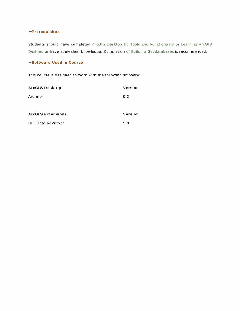
Prerequisites
Students should have completed ArcGIS Desktop II: Tools and Functionality or Learning ArcGIS
Desktop or have equivalent knowledge. Completion of Building Geodatabases
Software Used in Course
is recommended.
This course is designed to work with the following software:
ArcGIS Desktop Version
ArcInfo 9.3
ArcGIS Extensions Version
GIS Data ReViewer 9.3


![Video Editing and Production Checklist [digitalmedia]](https://img.pdfslide.us/doc/110x75/5565a7ded8b42a4c6f8b4592/video-editing-and-production-checklist-digitalmedia.jpg)