Embed Size (px)
Citation preview

Forschungszentrum Karlsruhe
in der Helmholtz - Gemeinschaft
GIS Data and Land Use in Life Cycle Impact assessment –experiences on global scales
Dr. Christian Bauer
Department for Technology Induced Material Flows
Forschungszentrum Karlsruhe
June 11th
Definition of Best Indicators for Land Use Impacts in Life Cycle Assessment
CES
University of Surrey

Forschungszentrum Karlsruhe
in der Helmholtz - Gemeinschaft
Introduction:
• Environmental Impact Assessment for Material Flows of
Metallic Raw Materials (Life Cycle Approach)
• Focus on primary production esp. mining
• Land use as major area of concern as aluminium/bauxite
was first example

Forschungszentrum Karlsruhe
in der Helmholtz - Gemeinschaft
Bauxite Mining (location, performance, production)

Forschungszentrum Karlsruhe
in der Helmholtz - Gemeinschaft
Cropland/Woodland Mosaic
Dryland Cropland and Pasture
Deciduous Broadleaf Forest
Grassland
grass crops
cool fields and woods
forest and field
cool crops and towns
cool broadleaf forest
low sparse grassland

Forschungszentrum Karlsruhe
in der Helmholtz - Gemeinschaft
460 mm/a ~ 14.5 l/(s km²)
360 mm/a ~ 11.4 l/(s km²)

Forschungszentrum Karlsruhe
in der Helmholtz - Gemeinschaft
surface cleaning soil compaction
degradation of
natural ecosystemremoval of topsoil
reduction of
permeability
change of natural
biodiverstiy
decrease of
nat. biomass
productivity
soil erosion by
wind
increase of
surface runoff
naturalness
indicator
ecosystem
indicator
reduction of
groundwater
recharge
soil erosion
by water
Cause – Effect Chain

Forschungszentrum Karlsruhe
in der Helmholtz - Gemeinschaft
0,01
0,1
1
10
100
land use
[ym²/t]
soil erosion by
wind [kg/t]
soil erosion by
water [kg/t]
ecosystem-
indicator [kg/t]
reduce of
GWR [t/t]
Australia
Jamaica
Brazil
China
USA
Germany
World
land use
[am²/t]
soil erosion by
wind [kg/t]
soil erosion by
water [kg/t]ecosystem-
indicator [kg/t]reduction of
GWR [t/t]
Indicator Scores

Forschungszentrum Karlsruhe
in der Helmholtz - Gemeinschaft
0
10
20
30
40
50
60
70
80
90
100
0,00 0,10 0,20 0,30 0,40 0,50 0,60 0,70 0,80 0,90 1,00
naturalness
bauxite p
roduction [
%]
Bauxite Mining & Naturalness
Darling Range, Australia
Trombetas, Brazil

Forschungszentrum Karlsruhe
in der Helmholtz - Gemeinschaft
0
10
20
30
40
50
60
70
80
90
100
0 0,5 1 1,5 2 2,5
net primary productivity
bauxite p
roduction [
%]
Bauxite Mining & Net Primary Productivity
Darling Range, Australia
Trombetas, Brazil
Forschungszentrum Karlsruhe
in der Helmholtz - Gemeinschaft
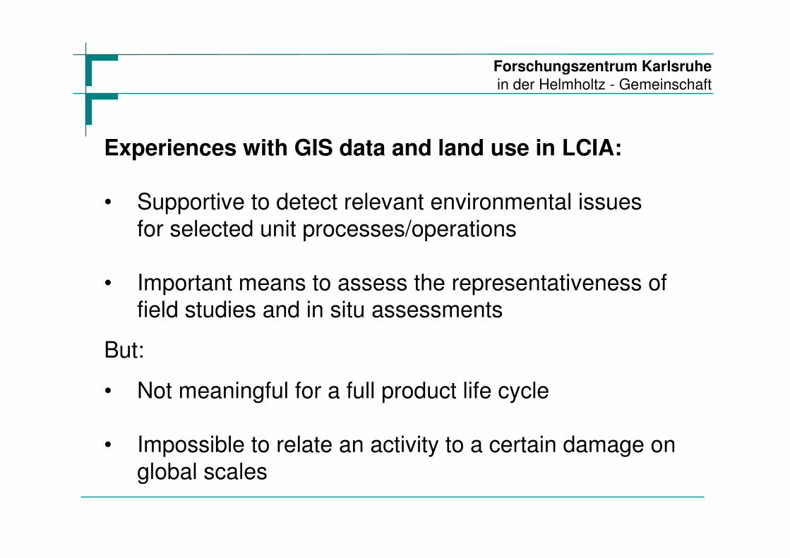
Experiences with GIS data and land use in LCIA:
• Supportive to detect relevant environmental issues
for selected unit processes/operations
• Important means to assess the representativeness offield studies and in situ assessments
• Not meaningful for a full product life cycle
• Impossible to relate an activity to a certain damage on
global scales
But:

Forschungszentrum Karlsruhe
in der Helmholtz - Gemeinschaft
forest
urban
cropland
savanna
mine site
pasture
50 km50 km50 km50 km
natural land cover [m²] N= = 0-1
land cover [m²]
E = N * NPPN,L [kg/t]
average net-primary-production of natural land coverNPPN, L=
t Bauxite

Forschungszentrum Karlsruhe
in der Helmholtz - Gemeinschaft
0
20
40
60
80
100
0 0,2 0,4 0,6 0,8 1
Naturalness
Co
pp
er
Pro
du
ctio
n (
%)
Chile
Canada
PeruAustraliaSth Africa
CyprusPhilippines

Forschungszentrum Karlsruhe
in der Helmholtz - Gemeinschaft
0
20
40
60
80
100
0 0,5 1 1,5 2 2,5
NPP
Co
pp
er
Pro
du
ctio
n (
%) PNG Colombia PhilippinesZimbabwe
USA/ Russia/ Canada
Australia
Peru
Chile
Zambia