Embed Size (px)
Citation preview

Doing it right from start . . . . . .
Abhishek Singh Petro IT Ltd.
GIS based Data Management System for New Pipeline Construction

Agenda
What is an integrated GIS based solution to track and archive new construction ?
How does a CMS help projects and operations teams ? A real life study of such a deployment
The benefits to team by implementing a GIS enabled web based CMS
What Will You Learn
Using a GIS based solution for construction management and material delivery How GIS based systems can be used for project quality assurance
Traceability during new construction and after How a GIS based CMS helps in regulatory and design compliance How GIS supports the integrity of historical record-keeping

Integrated GIS Based Solution
Pre Construction During Construction
Land Management & Asset Mapping
Alignment Sheets
Engineering Records
Construction Management
Project Certification Management
Material Management
Work Flows
Design Compliance/QA/Traceability

A Case Study…
Pipeline Owner – Indian Oil Corporation Limited
Diameter – 18/14/12/10 Pipeline Length – 670 Miles
Pipeline Contractors – 2
Number Of States – 3
Stations – 8
Districts – 16
Crossings – 1144
Number Of Forests – 590
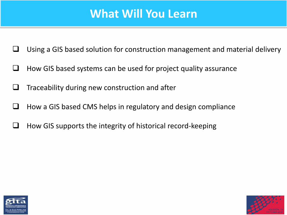
Project Challenges
Environmental clearances
Meeting Design Compliance Requirement
Traceability of material and work
Quality Assurance of Material and installation
Management of data and information
Capturing field data during execution
Project on-time delivery

A Case Study -Project Phases
Phase-I GIS Implementation ( Forest Mapping )
DGPS Survey
Delivery
Pre-construction stage
Phase-II Implementation of CMS
till handover
Asset Mapping
Handover to O/M
During Construction
Phase-III
System handover
Special Queries generation
Post Construction

Execution Strategy
Integration of Pre-construction information over GIS Application
Geo-referencing of Digital Map over route
Integration of Land management systems
Integration of Material management system
Implementation of new construction database Asset mapping for entire pipeline route
Integration of Completion and Certification system
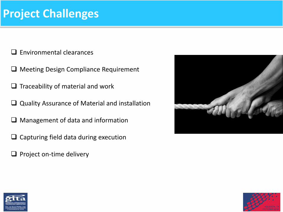
Preparation Of Forest Map From Cadastral Sheets
Merging of Cadastral Sheets to get a Complete Village Map

Forest Information

Forest Information

Land Parcels
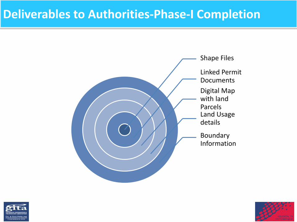
Deliverables to Authorities-Phase-I Completion
Shape Files
Linked Permit Documents Digital Map with land Parcels Land Usage details
Boundary Information

GIS Implementation Phase -II
• Spatial Analysis – Query based tools for Disaster Management – Population Density Information – Ground Elevation charting – Focused areas for CSR (Corporate Social Responsibility ) activities – Measurement tools – Risk Analysis Tools – HSE Reporting and alerts
• Data Collection – Ground survey 5 kms on either side of Route with 1 Mtr accuracy – Asset mapping survey (Stations, Police stations, Hospitals etc.) – Kilometer/Weld Joint locations – Pictures/Audio/Videos
• Web based Application – Integration with CMS/MT/PCMS/EDMS/OM/ASM – Alerts and Notification mechanism – Handover of application with editing feature
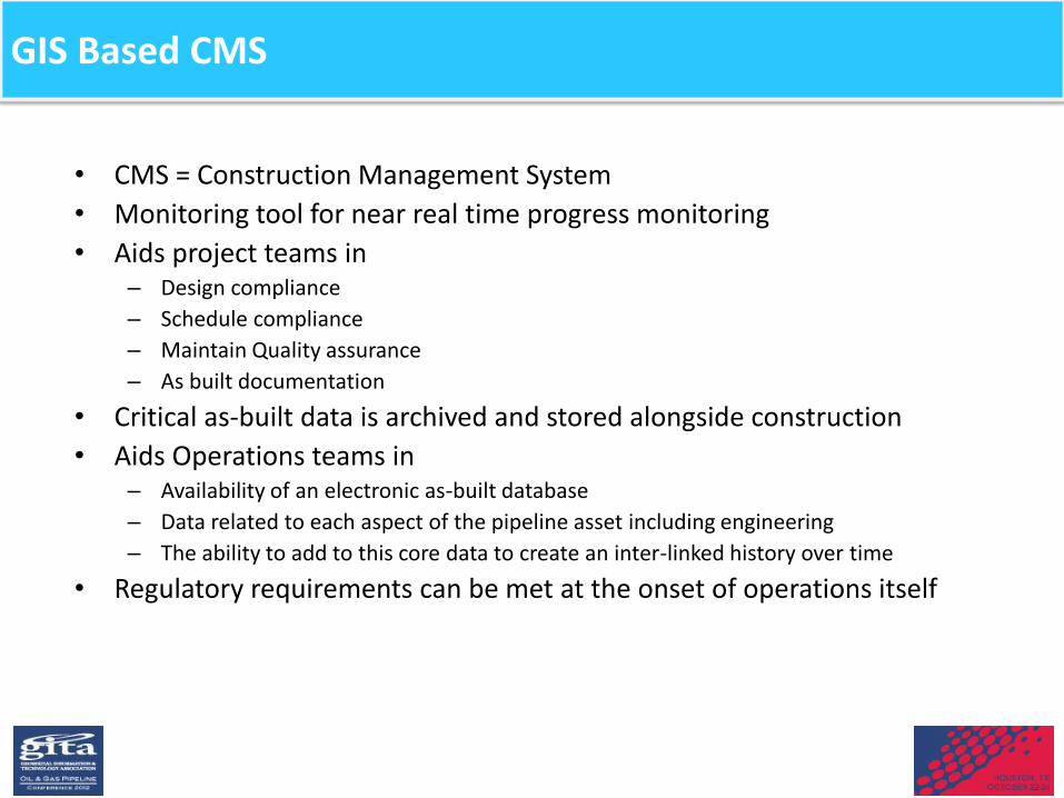
GIS Based CMS
• CMS = Construction Management System • Monitoring tool for near real time progress monitoring • Aids project teams in
– Design compliance – Schedule compliance – Maintain Quality assurance – As built documentation
• Critical as-built data is archived and stored alongside construction • Aids Operations teams in
– Availability of an electronic as-built database – Data related to each aspect of the pipeline asset including engineering – The ability to add to this core data to create an inter-linked history over time
• Regulatory requirements can be met at the onset of operations itself

Deployment of CMS
• Deployment stage : Project Execution Stage • Goal : To archive data related all the construction activities and
enhance the project monitoring mechanism • Need – Integrated application which brings together information
related to : – Land & Administration (Cadastral information ) – Materials (Free issue , Bought out materials ) – Pipeline Construction (Kilometer , Weld Information etc.) – Documentation (Engineering documentation ) – Certification (Certification management ) – Asset (Disaster Management ) – Operation and Maintenance

Cadastral Information-Land Management System
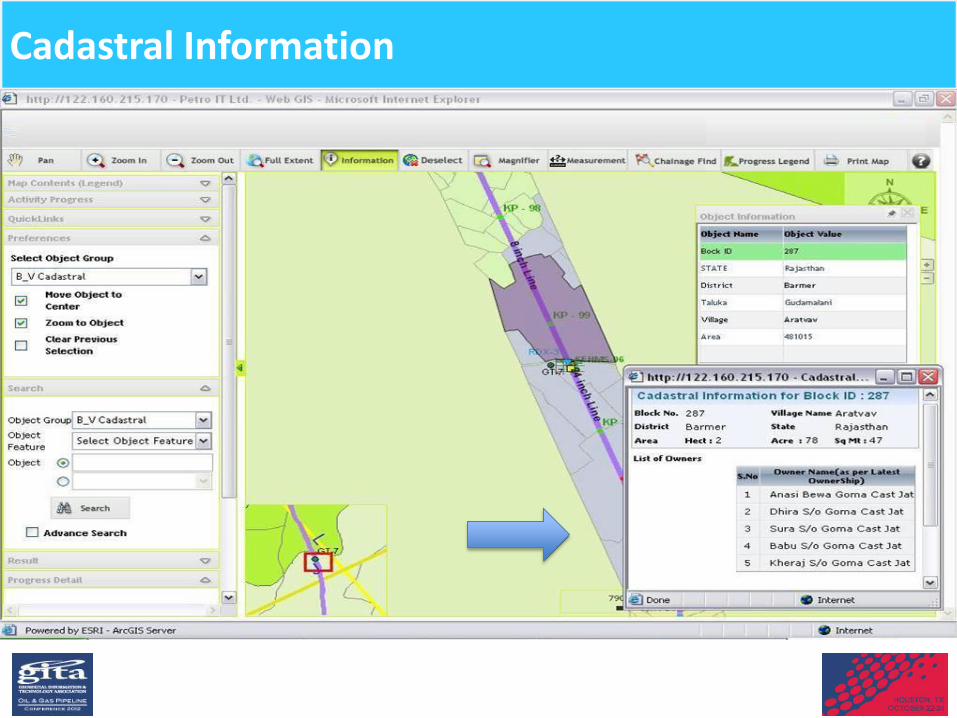
Cadastral Information

Managing Permits/Validity

Material Tracking

Material Information
PO Link

Tracing Cut Pipes
Pipe Reconciliation Report
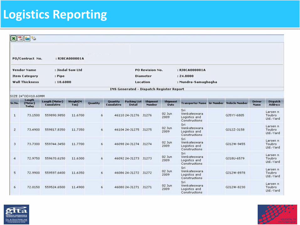
Logistics Reporting

Crossing Information

Stations Progress
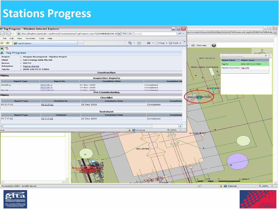
Stations Progress
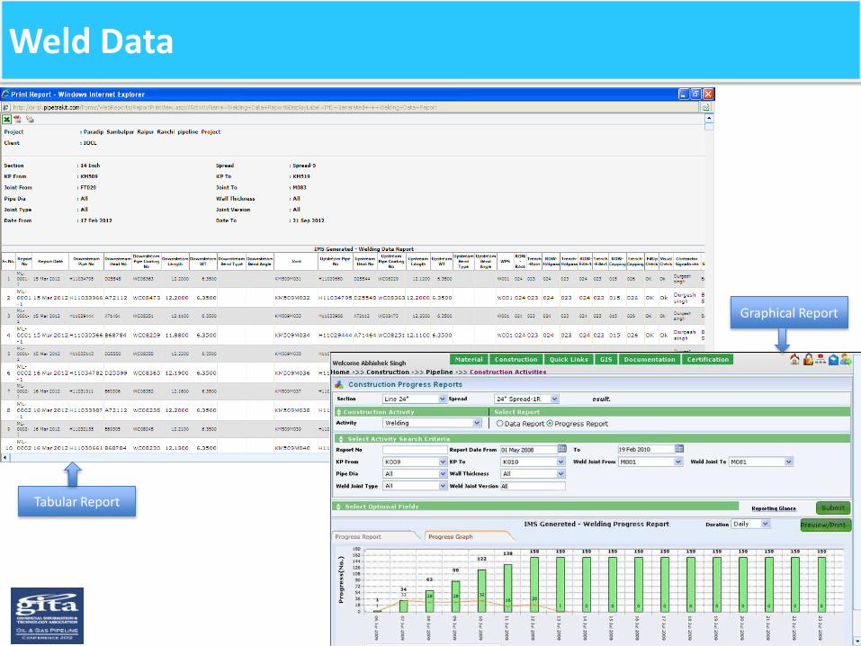
Weld Data
Tabular Report
Graphical Report

Statistics

Welder Performance
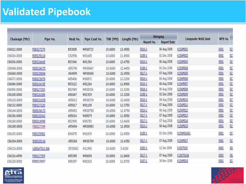
Validated Pipebook
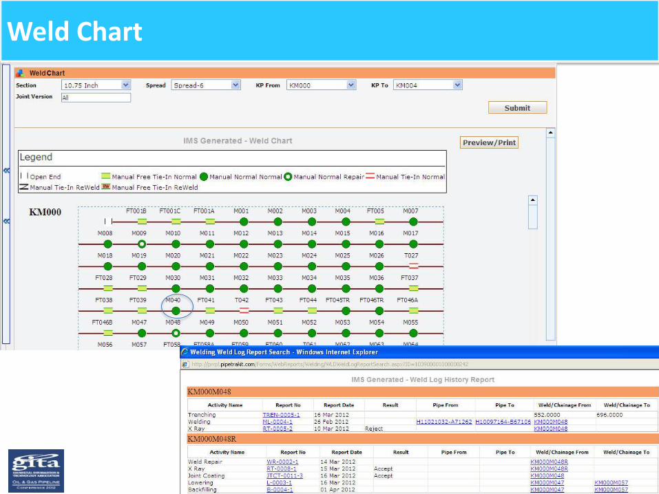
Weld Chart

NDT Information
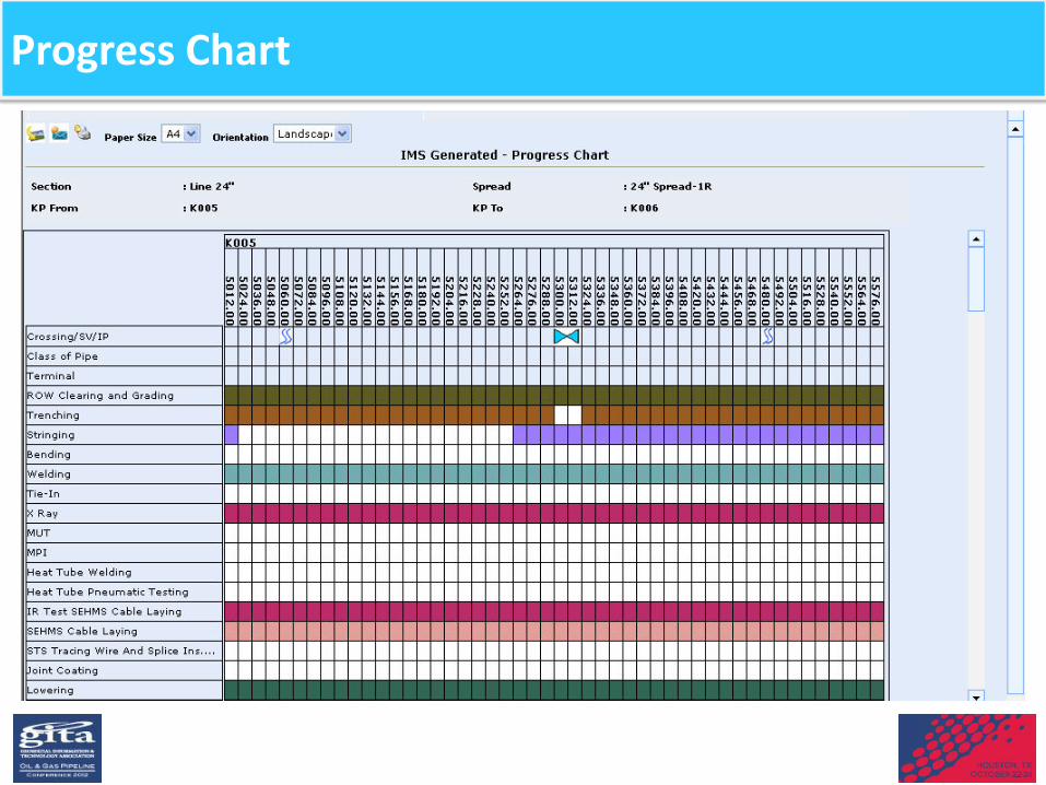
Progress Chart

Tie-In Chart

Progress Review Report

S-Curve

Construction Information
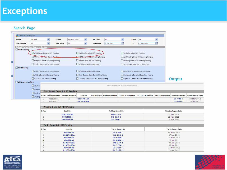
Exceptions
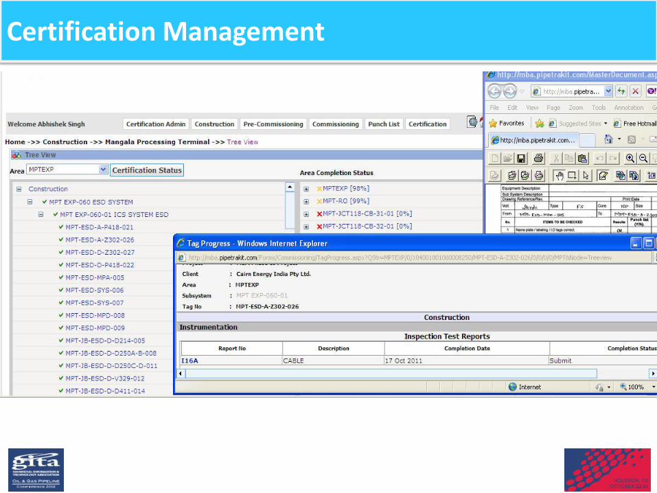
Certification Management
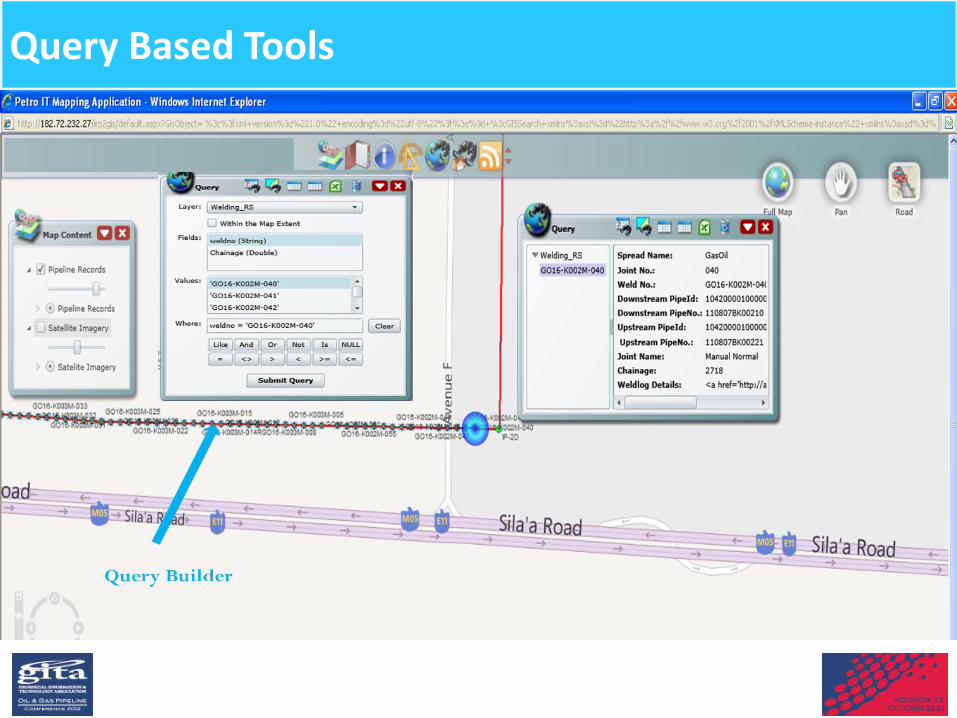
Query Based Tools
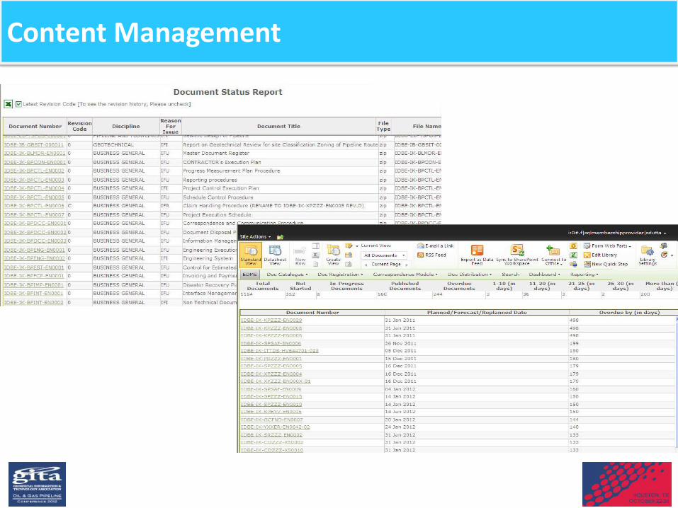
Content Management

Geo Tagged Information

As-built Information

Asset Mapping -Information
• Block Valve Stations • Test Lead Points • Turning Points • Private Structural Encroachments • Foreign Pipeline • Crossings • Boundary Marker • HOV/MOV • RCP/CP • KM Post • Land-details • Warning Signs • Hospitals • Fire Stations • Police Station • Retail Petrol Pump
Point Of Interest
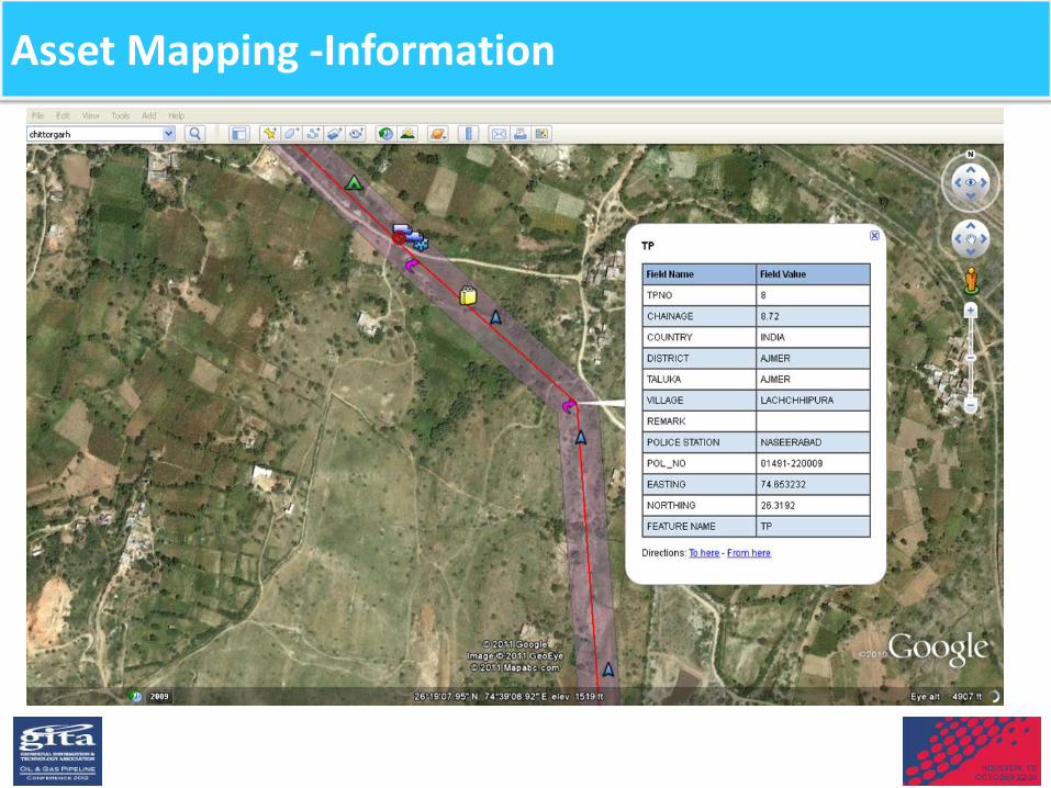
Asset Mapping -Information

Benefits to teams
Accurate Land Records : Helps identify and eliminate errors in data and parcel boundaries Less land conflicts: Safeguarding the records and prevent land disputes Record updation: History of property transfer as well as division of land parcels can be visualized Historical data overlaid with current land use data illustrates the impact of development within a community,
areas of greatest environmental pressure can be identified
Land and Administration
Information on critical aspects and events that describe a pipeline (Line pipe, facilities, CP etc.)
Analyzing and visualizing of historical HSE data assists in taking a well-informed decision-making Improves Fire Incidence Response
HSE Team
Benefits to teams
End of Day Progress and Compliance Reporting, enabling efficient project monitoring (over the web) Material Reconciliation
Interlinked Documentation
Real time progress monitoring
Smooth handover of data to operations team
Projects Team
Enables knowledge base to help plan effectively and mitigate risks associated with HSE Alert mechanism for accidents or ill health causation and keep teams in a state of better preparedness
Enhance the emergency response system
Detail information of Demographics available through one interface
Operation & Maintenance Team

Summary
GIS based CMS enables companies to save time , energy , paper , cost and many other impact areas
Regulatory requirements can be met at the onset of operations itself
Quick accessibility of data and information A GIS enabled CMS provides visualization and analysis of project activities, and
supports the more productive execution of work:
Construction activities and material delivery, and associated issues are managed and resolved near real-time
GIS visualization provides transparency of all work and issues to stakeholders Post-commissioning hand-off of documentation is seamless and does not
require months of re-engineering paperwork

Questions to ask during start of project ?
• How the regulatory requirements can be met using such systems?
• How to make use of available data and information ? • What would projects teams like in terms of critical monitoring
aids • What would we like in terms of information critical for
operations and maintenance teams? • What kind of information could help for future Integrity
management plans? • Set up such a system for capturing this relevant data at the
construction stage itself and then build on it

THANK YOU