Embed Size (px)
Citation preview
GINDALBIE METALS LIMITED Shine Iron Ore Project
Environmental Review Document
Assessment No. 1935 Document Date: 7 December 2012

SHINE IRON ORE PROJECT ENVIRONMENTAL REVIEW DOCUMENT P a g e | ii
Contents
1 PROPOSAL SUMMARY ................................................................................................. 1
2 KEY CHARACTERISTICS .............................................................................................. 7
3 SUPPORTING STUDIES ................................................................................................ 9
4 STAKEHOLDER CONSULTATION .............................................................................. 15
5 IMPACT ASSESSMENT ............................................................................................... 16
5.1 Potential Impacts on Flora Assemblage ................................................................. 16 5.2 Potential Impacts on Fauna Assemblage ............................................................... 23 5.3 Potential Impacts on Groundwater ......................................................................... 25 5.4 Rehabilitation and Mine Closure ............................................................................. 28 5.5 Residual Impacts .................................................................................................... 30
6 CUMULATIVE IMPACTS .............................................................................................. 33
6.1 Overview ................................................................................................................. 33 6.2 Data Limitations and Constraints ............................................................................ 35 6.3 BIF Ridges .............................................................................................................. 38 6.4 Flora and Fauna ..................................................................................................... 40
7 CONCLUSION ............................................................................................................... 46
8 REFERENCES .............................................................................................................. 47
Table 1 Key Project Characteristics ................................................................................................. 5 Table 2 Proponent Details ................................................................................................................. 6 Table 3 Summary of the Proposal .................................................................................................... 7 Table 4 Physical Elements ................................................................................................................ 7 Table 5 Operational Elements ........................................................................................................... 8 Table 6 Surveys undertaken for the Shine Iron Ore Project ........................................................ 11 Table 7 Consultations to date ......................................................................................................... 15 Table 8 Extent of clearing of Beard (1980) Vegetation Associations .......................................... 17 Table 9 Floristic Community Types (FCT) impacted by SIOP Disturbance Footprint .............. 19 Table 10 SIOP water balance .......................................................................................................... 27 Table 11 Summary of management measures for SIOP Key Environmental Factors ............... 31 Table 12 Cumulative impact of SIOP on flora and fauna ............................................................. 36 Table 13 Estimated population size at Shine................................................................................. 41 Table 14 Extent of probable occupied habitat and estimated population size across ridges
surveyed. .................................................................................................................................... 42 Table 15 Land systems comprising active Malleefowl mounds (extracted from Payne et al,
1998) ........................................................................................................................................... 44
SHINE IRON ORE PROJECT ENVIRONMENTAL REVIEW DOCUMENT P a g e | 1
1 PROPOSAL SUMMARY
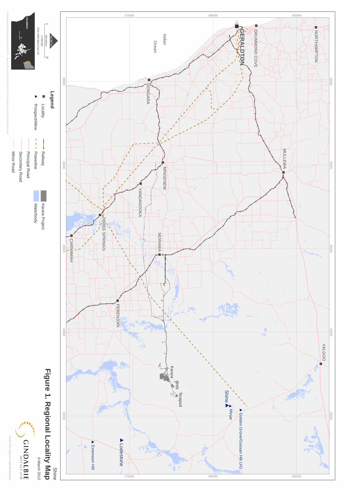
The Shine Iron Ore Project (SIOP, Project) proposal is for the development of an iron ore mine located approximately 68 km south east of Yalgoo and 30 km north east of the Greater Karara Iron Ore Project (Figure 1) being the Karara Iron Ore Project (KIOP) and the Mungada Iron Ore Project (MIOP). Gindalbie Metals Limited (GBG) is the proponent for this proposal.
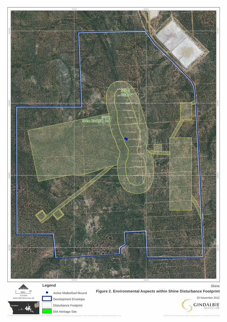
SIOP will mine an estimated 5 million tonnes of iron ore, with the current mine design allowing for an expected mine life of 5 years at a mining rate of 1 - 2 million tonnes per annum (Mtpa). The proposal will include a new minesite and supporting service infrastructure (Table 1). The total expected disturbance footprint is 200 ha within a development envelope of 646 ha, of which detailed environmental surveys have been undertaken (Figure 2 and 3, Table 1).
Mined material will be road hauled to the existing crushing and screening plant at the Blue Hills North minesite (part of the approved MIOP project, Ministerial Statement 806), and does not form part of this proposal. However, there is a potential that an additional new crushing and screening plant may be required at SIOP, and the disturbance footprint has been designed to accommodate for this (Figure 2).
A section 38 Referral of a Proposal in conjunction with a Proponent Information document was submitted to the Office of the Environmental Protection Authority (OEPA) on the 31 March 2012. The Proponent Information document provided additional detail in regards to the proposal and the commitment that SIOP will not have a significant impact on the surrounding environment. Based on the information provided, the OEPA deemed on the 6 August 2012 that the proposal would be assessed at a level of Assessment on Proponent Information (API). This Environmental Review document provides sufficient information to meet the OEPA requirements.
The key environmental factors within the OEPA’s API Scoping Guideline include;
Vegetation and Flora,
Fauna,
Groundwater and Surface water, and
Rehabilitation and Mine Closure.
These are discussed in further detail within this document. GBG believe that that these key environmental factors can be effectively managed through the SIOP Environmental Management Plan (EMP) as part of GBG’s ongoing environmental commitment.
Ge
raldto
n
#
#
#
" " " "
" "
" "
" "
" "
" "
" "
" "
" "
" "
" "
#
#
Ka
rara
BH
NTe
rap
od
Exte
nsio
n H
ill
Lod
eston
e
Min
jar
Go
lde
n G
rove
/Go
ssan
Hill U
/G
Sh
ine
YA
LG
OO
PE
RE
NJO
RI
YA
ND
AN
OO
KA
MO
RA
WA
DO
NG
AR
A
MU
LL
EW
A
CA
RN
AM
AH
MIN
GE
NE
W
NO
RT
HA
MP
TO
N
TH
RE
E S
PR
ING
S
DR
UM
MO
ND
CO
VE
GE
RA
LD
TO
N
300000
300000
350000
350000
400000
400000
450000
450000
500000
500000
6750000
6750000
6800000
6800000
6850000
6850000
Sh
ine
Fig
ure
1. Re
gio
na
l Lo
cality
Ma
p0
20kilo
me
tres
GD
A 1
99
4 M
GA
Zon
e 5
0
1:70
0,0
00
TS
-AP
P-S
hine R
egion
al Loca
lity-PB
-09M
ar201
2
9 Ma
rch 2
01
2
G:\E
xploratio
n\G
IS\M
ap
s\App
rovals\201
2\03 0
9 - Shin
e EP
BC
and E
PA
Refe
rral\TS
-AP
P-S
hine R
egion
al L
ocality-PB
-09M
ar20
12.m
xd
Le
ge
nd
" "L
oca
lity
#P
rosp
ect/M
ine
Ra
ilwa
y
Po
we
rline
Prin
cipa
l Ro
ad
Se
con
da
ry Ro
ad
Min
or R
oa
d
Ka
rara
Pro
ject
Wa
terb
od
y
Ind
ian
Oce
an
Geraldton
!!
31592ECAS01
31589Shine Rockhole One
493000
493000
494000
494000
6807
000
6807
000
6808
000
6808
000
6809
000
6809
000
6810
000
6810
000
Shine
Figure 2. Environmental Aspects within Shine Disturbance Footprint20 November 2012
TS-APP-Environmental Aspects within Shine Disturbance Footprint-PB-07Nov2012
0 200Meters
GDA 1994 MGA Zone 50
1:15,000
G:\Exploration\GIS\Maps\Approvals\2012\10 12 - Shine Development Envelope\TS-APP-Environmental Aspects within Shine Disturbance Footprint-PB-07Nov2012.mxd
Legend
! Active Malleefowl Mound
Development Envelope
Disturbance Footprint
DIA Heritage Site
Geraldton
!!
!!
!!
!!
493000
493000
494000
494000
6807
000
6807
000
6808
000
6808
000
6809
000
6809
000
6810
000
6810
000
ShineFigure 3. Environmental Aspects within Shine Development Envelope
20 November 2012
TS-APP-Environmental Aspects within Shine Development Envelope-PB-20Nov2012
0 200Meters
GDA 1994 MGA Zone 50
1:15,000
G:\Exploration\GIS\Maps\Approvals\2012\10 12 - Shine Development Envelope\TS-APP-Environmental Aspects within Shine Development Envelope-PB-20Nov2012.mxd
Legend
Development Envelope
Disturbance Footprint
!! Active Malleefowl Mound
DIA Heritage Site
30m Avoidance Buffer
Avoidance Sites

SHINE IRON ORE PROJECT ENVIRONMENTAL REVIEW DOCUMENT P a g e | 5
Table 1 Key Project Characteristics
Aspect Project Element
Detail
General Project life
Approximately 2 years, with option to extend to a maximum of 5 years (depending on mining rate).
Reserve Approximately 5 Mt of iron ore at 55% cut-off.
Timing Construction to commence within 2 months of gaining approvals. First shipment of hematite product within 6 months of gaining approvals.
Production rate Approximately 1 - 2 Mtpa of iron ore.
Land Disturbance
Disturbance footprint
Up to 200 ha
Mining
Method Conventional open pits.
Operations 12 hours per day, 7 days per week.
Total mining rate
Approximately 12 Mtpa
Stripping Ratio 6.4:1
Waste rock mining rate
Approximately 10-15 Mtpa
Pit depth Approximately 115 m
Waste rock management
Waste dump located to the west of the pits. No potentially acid-forming (PAF) material identified
Mineralised waste storage
Stored in a combined facility with the waste rock.
Product Transport
Product transport
Transportation of iron ore via road trains to the Blue Hills North minesite (crushing and screening plant), hematite product to the Karara rail loop and product then railed to the Geraldton Port for export. Transportation related activities for SIOP are not considered part of the scope of this referral document.
Supporting Infrastructure
Minesite infrastructure
Includes equipment maintenance workshops, hardstand areas, portable refuelling facilities, washdown bays, administration buildings, magazine, turkey’s nest, and laydown storage areas.
The accommodation, bioremediation, landfill and drinking water supply facilities are owned and operated by Minjar Gold and may be used for SIOP (however are excluded from the scope of this document).
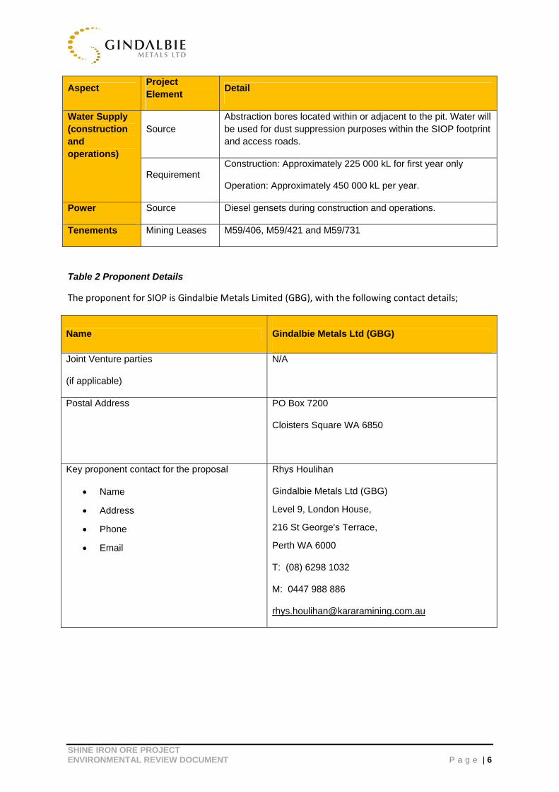
SHINE IRON ORE PROJECT ENVIRONMENTAL REVIEW DOCUMENT P a g e | 6
Aspect Project Element
Detail
Water Supply (construction and operations)
Source Abstraction bores located within or adjacent to the pit. Water will be used for dust suppression purposes within the SIOP footprint and access roads.
Requirement Construction: Approximately 225 000 kL for first year only
Operation: Approximately 450 000 kL per year.
Power Source Diesel gensets during construction and operations.
Tenements Mining Leases M59/406, M59/421 and M59/731
Table 2 Proponent Details
The proponent for SIOP is Gindalbie Metals Limited (GBG), with the following contact details;
Name Gindalbie Metals Ltd (GBG)
Joint Venture parties
(if applicable)
N/A
Postal Address PO Box 7200
Cloisters Square WA 6850
Key proponent contact for the proposal
Name
Address
Phone
Rhys Houlihan
Gindalbie Metals Ltd (GBG)
Level 9, London House,
216 St George's Terrace,
Perth WA 6000
T: (08) 6298 1032
M: 0447 988 886
SHINE IRON ORE PROJECT ENVIRONMENTAL REVIEW DOCUMENT P a g e | 7
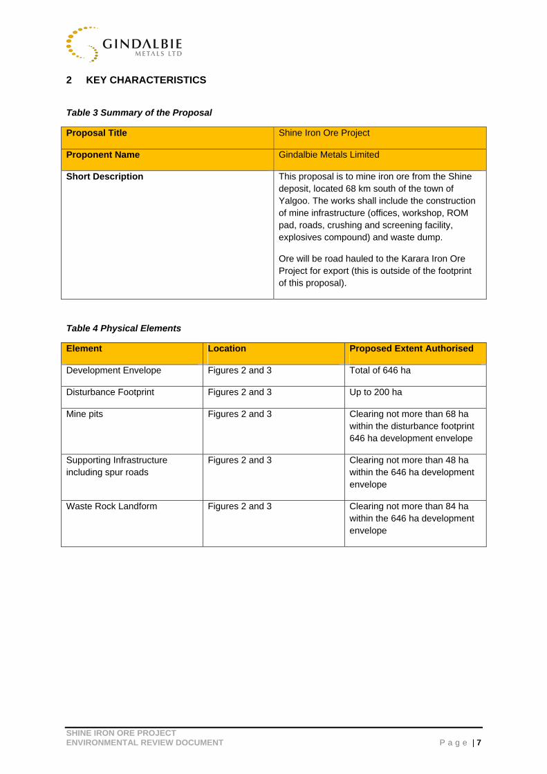
2 KEY CHARACTERISTICS
Table 3 Summary of the Proposal
Proposal Title Shine Iron Ore Project
Proponent Name Gindalbie Metals Limited
Short Description This proposal is to mine iron ore from the Shine deposit, located 68 km south of the town of Yalgoo. The works shall include the construction of mine infrastructure (offices, workshop, ROM pad, roads, crushing and screening facility, explosives compound) and waste dump.
Ore will be road hauled to the Karara Iron Ore Project for export (this is outside of the footprint of this proposal).
Table 4 Physical Elements
Element Location Proposed Extent Authorised
Development Envelope Figures 2 and 3 Total of 646 ha
Disturbance Footprint Figures 2 and 3 Up to 200 ha
Mine pits Figures 2 and 3 Clearing not more than 68 ha within the disturbance footprint 646 ha development envelope
Supporting Infrastructure including spur roads
Figures 2 and 3 Clearing not more than 48 ha within the 646 ha development envelope
Waste Rock Landform Figures 2 and 3 Clearing not more than 84 ha within the 646 ha development envelope
SHINE IRON ORE PROJECT ENVIRONMENTAL REVIEW DOCUMENT P a g e | 8
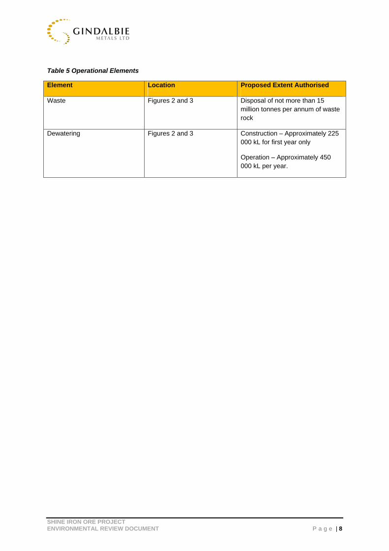
Table 5 Operational Elements
Element Location Proposed Extent Authorised
Waste Figures 2 and 3 Disposal of not more than 15 million tonnes per annum of waste rock
Dewatering Figures 2 and 3 Construction – Approximately 225 000 kL for first year only
Operation – Approximately 450 000 kL per year.

SHINE IRON ORE PROJECT ENVIRONMENTAL REVIEW DOCUMENT P a g e | 9
3 SUPPORTING STUDIES
GBG has commissioned specialist consultants to undertake a number of detailed studies, within the development envelope, to ensure all aspects of the project are appropriately managed and addressed. These are summarised in diagrammatic and tabular form in Figure 4 and Table 6, respectively.
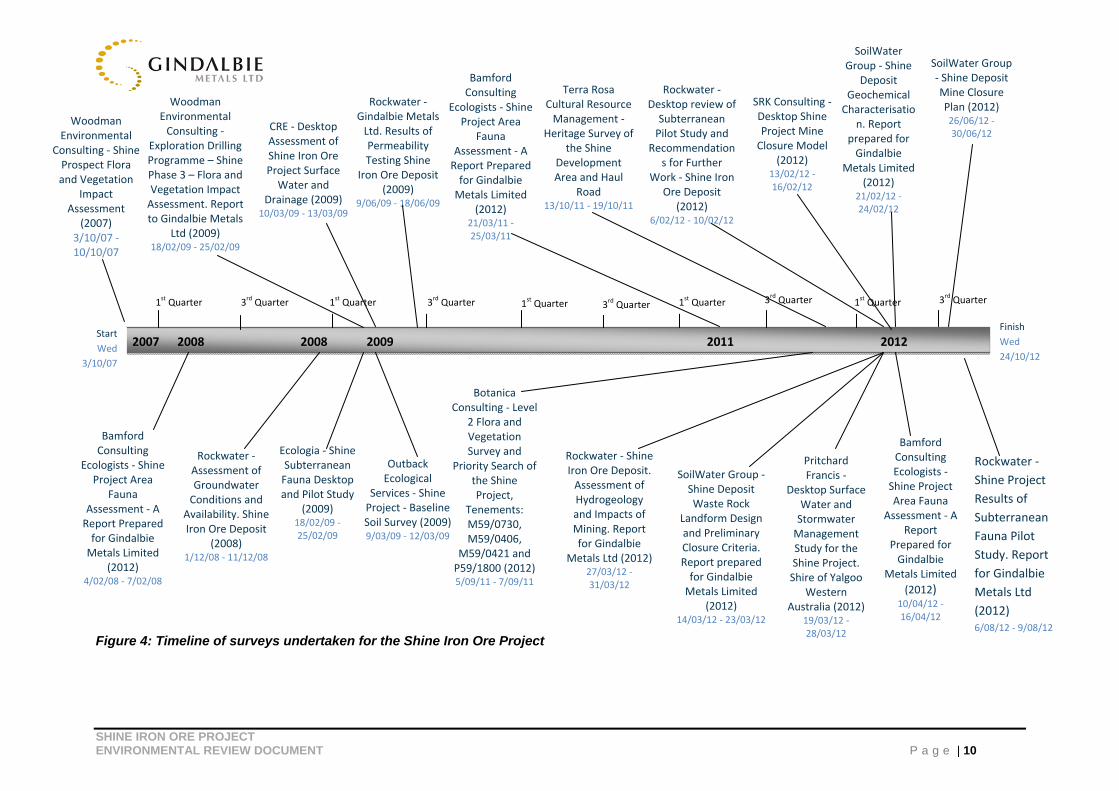
SHINE IRON ORE PROJECT ENVIRONMENTAL REVIEW DOCUMENT P a g e | 10
Figure 4: Timeline of surveys undertaken for the Shine Iron Ore Project
Woodman Environmental
Consulting ‐ Shine Prospect Flora and Vegetation
Impact Assessment
(2007) 3/10/07 ‐ 10/10/07
Woodman Environmental Consulting ‐
Exploration Drilling Programme – Shine Phase 3 – Flora and Vegetation Impact Assessment. Report to Gindalbie Metals
Ltd (2009) 18/02/09 ‐ 25/02/09
2007 2008 2008 2009 2011 2012
CRE ‐ Desktop Assessment of Shine Iron Ore Project Surface Water and
Drainage (2009)10/03/09 ‐ 13/03/09
Rockwater ‐ Gindalbie Metals Ltd. Results of Permeability Testing Shine
Iron Ore Deposit (2009)
9/06/09 ‐ 18/06/09
Bamford Consulting
Ecologists ‐ Shine Project Area
Fauna Assessment ‐ A Report Prepared for Gindalbie Metals Limited
(2012) 21/03/11 ‐ 25/03/11
Terra Rosa Cultural Resource Management ‐
Heritage Survey of the Shine
Development Area and Haul
Road 13/10/11 ‐ 19/10/11
Rockwater ‐ Desktop review of Subterranean Pilot Study and
Recommendations for Further
Work ‐ Shine Iron Ore Deposit
(2012) 6/02/12 ‐ 10/02/12
SRK Consulting ‐ Desktop Shine Project Mine Closure Model
(2012) 13/02/12 ‐ 16/02/12
SoilWater Group ‐ Shine
Deposit Geochemical Characterisatio
n. Report prepared for Gindalbie
Metals Limited (2012)
21/02/12 ‐ 24/02/12
SoilWater Group ‐ Shine Deposit Mine Closure Plan (2012) 26/06/12 ‐ 30/06/12
1stQuarter 3
rd Quarter 1
stQuarter1
stQuarter 3
rdQuarter 3
rd Quarter 1
stQuarter 3
rdQuarter 1
stQuarter3
rdQuarter
Start
Wed
3/10/07
Finish
Wed
24/10/12
Bamford Consulting
Ecologists ‐ Shine Project Area
Fauna Assessment ‐ A Report Prepared for Gindalbie Metals Limited
(2012) 4/02/08 ‐ 7/02/08
Rockwater ‐ Assessment of Groundwater Conditions and
Availability. Shine Iron Ore Deposit
(2008) 1/12/08 ‐ 11/12/08
Ecologia ‐ Shine Subterranean Fauna Desktop and Pilot Study
(2009) 18/02/09 ‐ 25/02/09
Outback Ecological
Services ‐ Shine Project ‐ Baseline Soil Survey (2009)9/03/09 ‐ 12/03/09
Botanica Consulting ‐ Level
2 Flora and Vegetation Survey and
Priority Search of the Shine Project,
Tenements: M59/0730, M59/0406,
M59/0421 and P59/1800 (2012)5/09/11 ‐ 7/09/11
Rockwater ‐ Shine Iron Ore Deposit. Assessment of Hydrogeology and Impacts of Mining. Report for Gindalbie
Metals Ltd (2012) 27/03/12 ‐ 31/03/12
SoilWater Group ‐Shine Deposit Waste Rock
Landform Design and Preliminary Closure Criteria. Report prepared for Gindalbie Metals Limited
(2012) 14/03/12 ‐ 23/03/12
Pritchard Francis ‐
Desktop Surface Water and Stormwater Management Study for the Shine Project. Shire of Yalgoo
Western Australia (2012)
19/03/12 ‐ 28/03/12
Bamford Consulting Ecologists ‐ Shine Project Area Fauna
Assessment ‐ A Report
Prepared for Gindalbie
Metals Limited
(2012) 10/04/12 ‐ 16/04/12
Rockwater ‐
Shine Project
Results of
Subterranean
Fauna Pilot
Study. Report
for Gindalbie
Metals Ltd
(2012) 6/08/12 ‐ 9/08/12
SHINE IRON ORE PROJECT ENVIRONMENTAL REVIEW DOCUMENT P a g e | 11
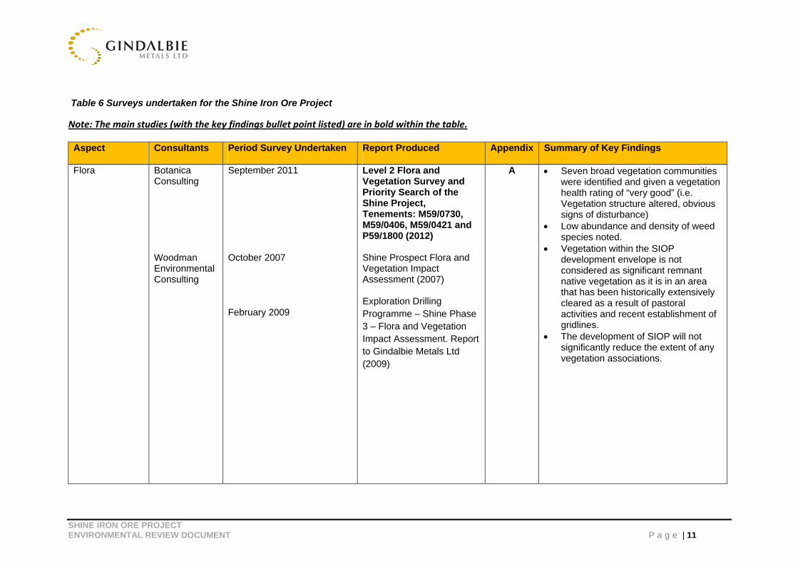
Table 6 Surveys undertaken for the Shine Iron Ore Project
Note: The main studies (with the key findings bullet point listed) are in bold within the table.
Aspect Consultants Period Survey Undertaken Report Produced Appendix Summary of Key Findings
Flora Botanica Consulting Woodman Environmental Consulting
September 2011 October 2007
February 2009
Level 2 Flora and Vegetation Survey and Priority Search of the Shine Project, Tenements: M59/0730, M59/0406, M59/0421 and P59/1800 (2012) Shine Prospect Flora and Vegetation Impact Assessment (2007) Exploration Drilling Programme – Shine Phase 3 – Flora and Vegetation Impact Assessment. Report to Gindalbie Metals Ltd (2009)
A Seven broad vegetation communities were identified and given a vegetation health rating of “very good” (i.e. Vegetation structure altered, obvious signs of disturbance)
Low abundance and density of weed species noted.
Vegetation within the SIOP development envelope is not considered as significant remnant native vegetation as it is in an area that has been historically extensively cleared as a result of pastoral activities and recent establishment of gridlines.
The development of SIOP will not significantly reduce the extent of any vegetation associations.
SHINE IRON ORE PROJECT ENVIRONMENTAL REVIEW DOCUMENT P a g e | 12
Aspect Consultants Period Survey Undertaken Report Produced Appendix Summary of Key Findings
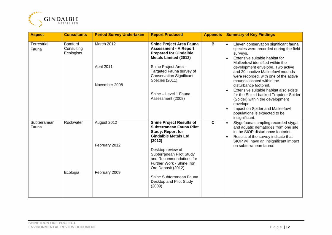
Terrestrial Fauna
Bamford Consulting Ecologists
March 2012 April 2011 November 2008
Shine Project Area Fauna Assessment - A Report Prepared for Gindalbie Metals Limited (2012) Shine Project Area – Targeted Fauna survey of Conservation Significant Species (2011) Shine – Level 1 Fauna Assessment (2008)
B Eleven conservation significant fauna species were recorded during the field surveys.
Extensive suitable habitat for Malleefowl identified within the development envelope. Two active and 20 inactive Malleefowl mounds were recorded, with one of the active mounds located within the disturbance footprint.
Extensive suitable habitat also exists for the Shield-backed Trapdoor Spider (Spider) within the development envelope.
Impact on Spider and Malleefowl populations is expected to be insignificant.
Subterranean Fauna
Rockwater Ecologia
August 2012 February 2012 February 2009
Shine Project Results of Subterranean Fauna Pilot Study. Report for Gindalbie Metals Ltd (2012) Desktop review of Subterranean Pilot Study and Recommendations for Further Work - Shine Iron Ore Deposit (2012) Shine Subterranean Fauna Desktop and Pilot Study (2009)
C Stygofauna sampling recorded stygal and aquatic nematodes from one site in the SIOP disturbance footprint.
Results of the survey indicate that SIOP will have an insignificant impact on subterranean fauna.
SHINE IRON ORE PROJECT ENVIRONMENTAL REVIEW DOCUMENT P a g e | 13
Aspect Consultants Period Survey Undertaken Report Produced Appendix Summary of Key Findings
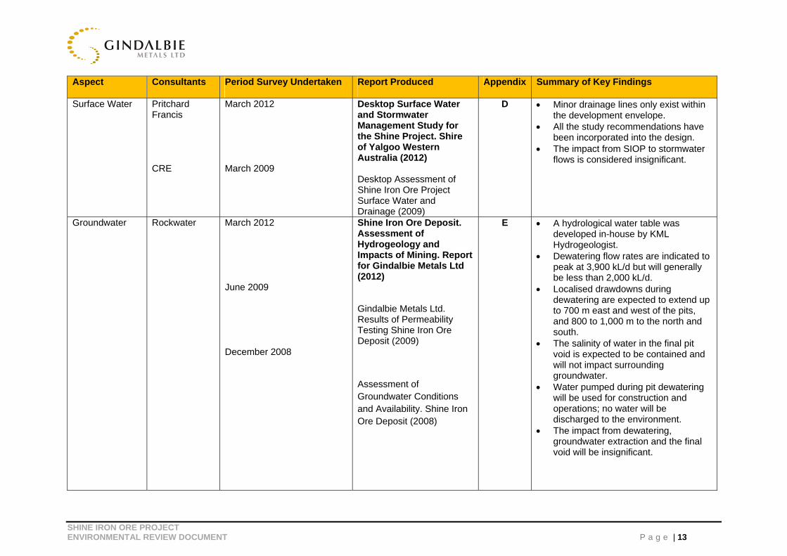
Surface Water
Pritchard Francis CRE
March 2012 March 2009
Desktop Surface Water and Stormwater Management Study for the Shine Project. Shire of Yalgoo Western Australia (2012) Desktop Assessment of Shine Iron Ore Project Surface Water and Drainage (2009)
D Minor drainage lines only exist within the development envelope.
All the study recommendations have been incorporated into the design.
The impact from SIOP to stormwater flows is considered insignificant.
Groundwater Rockwater March 2012 June 2009
December 2008
Shine Iron Ore Deposit. Assessment of Hydrogeology and Impacts of Mining. Report for Gindalbie Metals Ltd (2012) Gindalbie Metals Ltd. Results of Permeability Testing Shine Iron Ore Deposit (2009)
Assessment of Groundwater Conditions and Availability. Shine Iron Ore Deposit (2008)
E A hydrological water table was developed in-house by KML Hydrogeologist.
Dewatering flow rates are indicated to peak at 3,900 kL/d but will generally be less than 2,000 kL/d.
Localised drawdowns during dewatering are expected to extend up to 700 m east and west of the pits, and 800 to 1,000 m to the north and south.
The salinity of water in the final pit void is expected to be contained and will not impact surrounding groundwater.
Water pumped during pit dewatering will be used for construction and operations; no water will be discharged to the environment.
The impact from dewatering, groundwater extraction and the final void will be insignificant.
SHINE IRON ORE PROJECT ENVIRONMENTAL REVIEW DOCUMENT P a g e | 14
Aspect Consultants Period Survey Undertaken Report Produced Appendix Summary of Key Findings
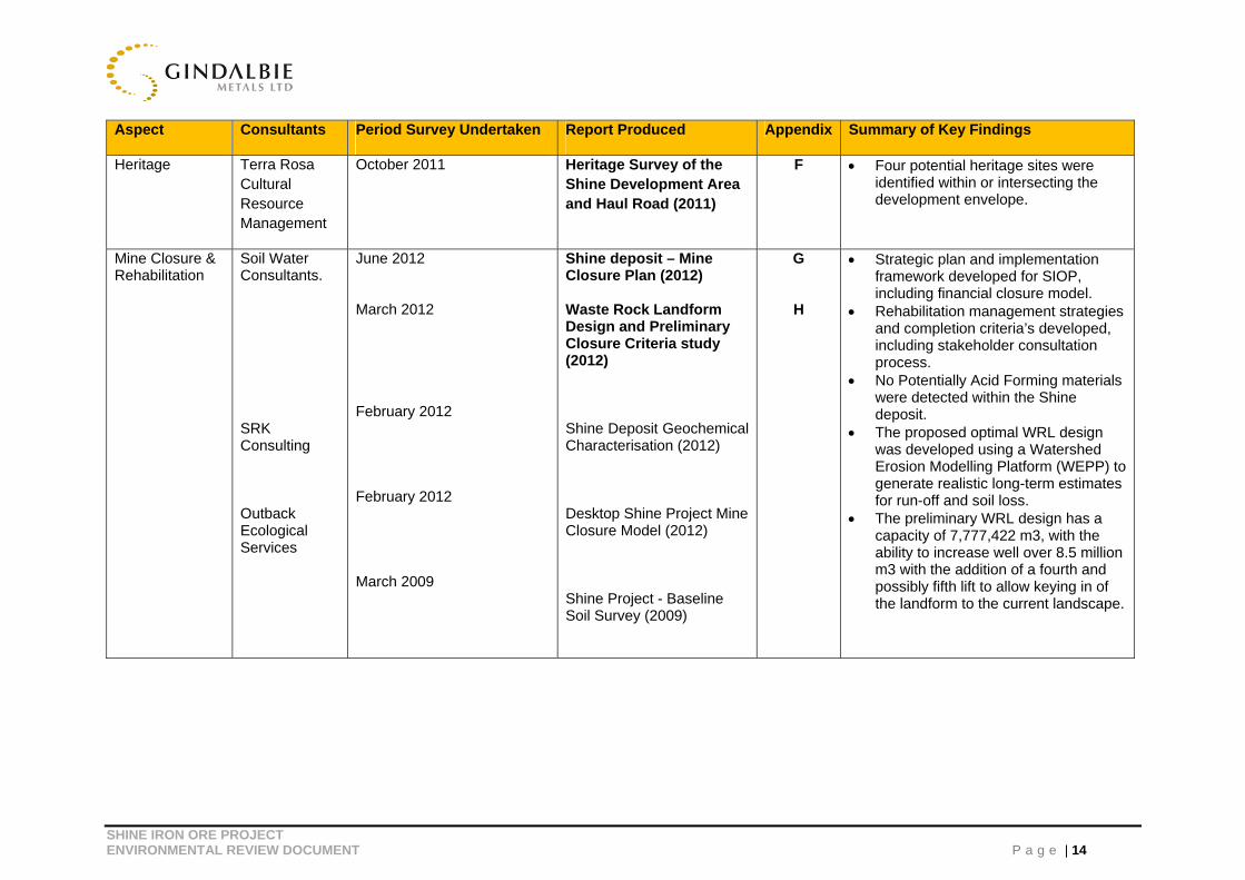
Heritage Terra Rosa Cultural Resource Management
October 2011 Heritage Survey of the Shine Development Area and Haul Road (2011)
F Four potential heritage sites were identified within or intersecting the development envelope.
Mine Closure & Rehabilitation
Soil Water Consultants. SRK Consulting Outback Ecological Services
June 2012 March 2012 February 2012 February 2012 March 2009
Shine deposit – Mine Closure Plan (2012) Waste Rock Landform Design and Preliminary Closure Criteria study (2012) Shine Deposit Geochemical Characterisation (2012) Desktop Shine Project Mine Closure Model (2012) Shine Project - Baseline Soil Survey (2009)
G
H
Strategic plan and implementation framework developed for SIOP, including financial closure model.
Rehabilitation management strategies and completion criteria’s developed, including stakeholder consultation process.
No Potentially Acid Forming materials were detected within the Shine deposit.
The proposed optimal WRL design was developed using a Watershed Erosion Modelling Platform (WEPP) to generate realistic long-term estimates for run-off and soil loss.
The preliminary WRL design has a capacity of 7,777,422 m3, with the ability to increase well over 8.5 million m3 with the addition of a fourth and possibly fifth lift to allow keying in of the landform to the current landscape.

SHINE IRON ORE PROJECT ENVIRONMENTAL REVIEW DOCUMENT P a g e | 15
4 STAKEHOLDER CONSULTATION
GBG has undertaken extensive stakeholder consultation with regulators and other key stakeholders for SIOP to ensure that any potential concerns are appropriately addressed.
Input from regulatory agencies has been sought throughout the development of the project. Feedback and advice received during this consultation process has been incorporated into the design of the project.
Refer to Table 7 below for a summary of consultations to date with key stakeholders.
Table 7 Consultations to date
Organization/Individual Consulted
Contact Person Date Contacted
Topics Discussed and Outcomes
Department of Sustainability, Environment, Water, Populations and Communities (SEWPAC)
David Way 24/11/11 Shine Project in general. EPBC referral requirements.
Department of Mines and Petroleum (DMP)
Eugene Bouwhuis and Tyler Sjudovic
9/12/11 Shine Project in general especially potential impacts on fauna and flora within the footprint of the Project, and mine site design.
Shire of Yalgoo Sharon Daishe (CEO)
08/12/11 Shine Project in general. Potential involvement with the Shire of Yalgoo.
Department of Indigenous Affairs (DIA)
Shaye Hayden 30/01/12 Summary of the Shine Project. Heritage impacts of the Shine Project. Requirements for Section 18 approval.
Department of Environment and Conservation (DEC) Perth Environmental Management Branch
Nic Woolfrey, Melissa Cundy, Anthea Jones and Murray Baker
07/09/11 Shine Project in general. Approval requirements.
Office of Environmental Protection Authority (OEPA)
Mark Jefferies and Anthony Sutton Mark Jefferies and Chris Stanley Chris Stanley
25/08/11 27/09/12 15/10/12 & 13/11/12
Shine Project in general. Approval requirements. Environmental Review document requirements in response to API Scoping Guideline. Reviewed working draft of the Environmental Review document. Confirmed that document should focus succinct discussions to potential significant impacts only ie. Flora – Minjar/Gnows Nest PEC, Fauna – Malleefowl and Shield-backed Trapdoor Spider, Groundwater and Rehabilitation and Mine Closure.
Department of Water (DoW) Natalie Lauritsen 23/02/12 Shine Project in general. 5C licence to abstract water required from DoW.
SHINE IRON ORE PROJECT ENVIRONMENTAL REVIEW DOCUMENT P a g e | 16
5 IMPACT ASSESSMENT
The key environmental factors identified by the OEPA as relevant to the proposal and requiring further evaluation include terrestrial fauna, flora, groundwater, rehabilitation and mine closure. These are discussed in detail below.
5.1 Potential Impacts on Flora Assemblage
EPA Objective: Maintain the diversity, geographic distribution and productivity of flora at species and ecosystem levels through the avoidance or management of adverse impacts and the improvement of knowledge.
Project Impacts
No Threatened flora species and only three Priority 3 Flora species were identified within the SIOP disturbance footprint; Calytrix uncinata, Drummondita fulva and Micromyrtus trudgenii (Botanica Consulting, 2012).
Flora surveys identified a total of 662 Calytrix unicata within the regional area in which SIOP has a total impact of 3, approximately 0.45%. Calytrix unicata has a relatively wide distribution of approximately 550 km, with numerous records from the Yalgoo and Murchison bio-regions, particularly near Leinster and Leonora (WEC, 2012). This species has also been recorded by Woodman Environmental at Pinyalling Hill to the east and Gossan Hill to the north (WEC, 2007).
A total of 14,574 Drummondita fulva recorded in the regional area in which SIOP has a total impact of 4,978, approximately 34%. Drummondita fulva has been recorded at rocky areas with ironstone outcropping on the slopes and crests of ridges within the Karara-Mungada Project survey area (Markey & Dillon 2008; Woodman Environmental 2008), mainly within the Mungada Ridge area, and in the Chulaar and Minjar areas. This species has a known range of 43 km N-S and 23 km E-W. This species was recorded widely during the regional mapping survey, and was recorded in 49 quadrats (WEC, 2012).
There are a total of 17,765 Micromyrtus trudgenii recorded in the regional area in which SIOP has a total impact of 1,230 plants, approximately 6.9%. Micromyrtus trudgenii has a range of approximately 100 km, and includes the DEC-managed ex-pastoral Karara and Warriedar stations, as well as Wanarra and Badja Stations, and other areas of private property. This taxon was recorded in 53 quadrats during the regional mapping survey, as well as being recorded in numerous quadrats in previous surveys within and outside the regional mapping survey area (WEC, 2012). The identified total Priority Flora are based on surveys undertaken on GBG and KML leases and records from the Department of Environment and Conservation’s Flora Base; based on this information, the total population numbers across the region are expected to be larger than stated above. Therefore it can be anticipated that there is prominently more individuals in areas not yet covered by survey.
SHINE IRON ORE PROJECT ENVIRONMENTAL REVIEW DOCUMENT P a g e | 17
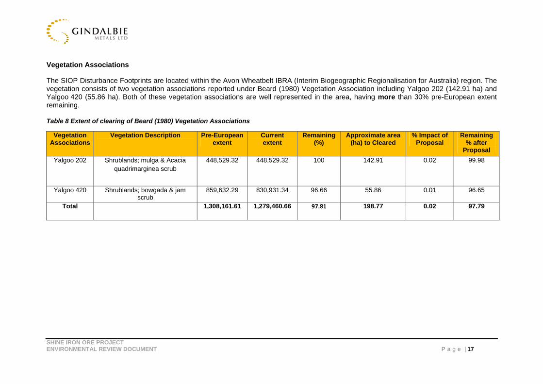
Vegetation Associations
The SIOP Disturbance Footprints are located within the Avon Wheatbelt IBRA (Interim Biogeographic Regionalisation for Australia) region. The vegetation consists of two vegetation associations reported under Beard (1980) Vegetation Association including Yalgoo 202 (142.91 ha) and Yalgoo 420 (55.86 ha). Both of these vegetation associations are well represented in the area, having more than 30% pre-European extent remaining. Table 8 Extent of clearing of Beard (1980) Vegetation Associations
Vegetation Associations
Vegetation Description Pre-European extent
Current extent
Remaining (%)
Approximate area (ha) to Cleared
% Impact of Proposal
Remaining % after
Proposal
Yalgoo 202 Shrublands; mulga & Acacia quadrimarginea scrub
448,529.32
448,529.32
100
142.91 0.02 99.98
Yalgoo 420 Shrublands; bowgada & jam scrub
859,632.29 830,931.34 96.66 55.86 0.01 96.65
Total 1,308,161.61 1,279,460.66 97.81
198.77
0.02 97.79
SHINE IRON ORE PROJECT ENVIRONMENTAL REVIEW DOCUMENT P a g e | 18
Introduced Species Four weed species, Mesembryanthemum crystallinum (Ice Plant), Cuscata laniflora, Pentaschistis airoides subsp. airoides and Cenchrus echinatus (Burrgrass) were recorded within the development envelope (Botanica Consulting, 2012). According to the DAFWA database, none of these species is listed as Declared Plants (Botanica Consulting, 2012).
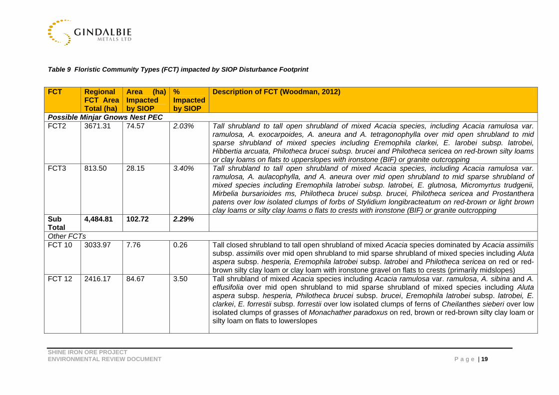
Floristic Community Types (FCT)
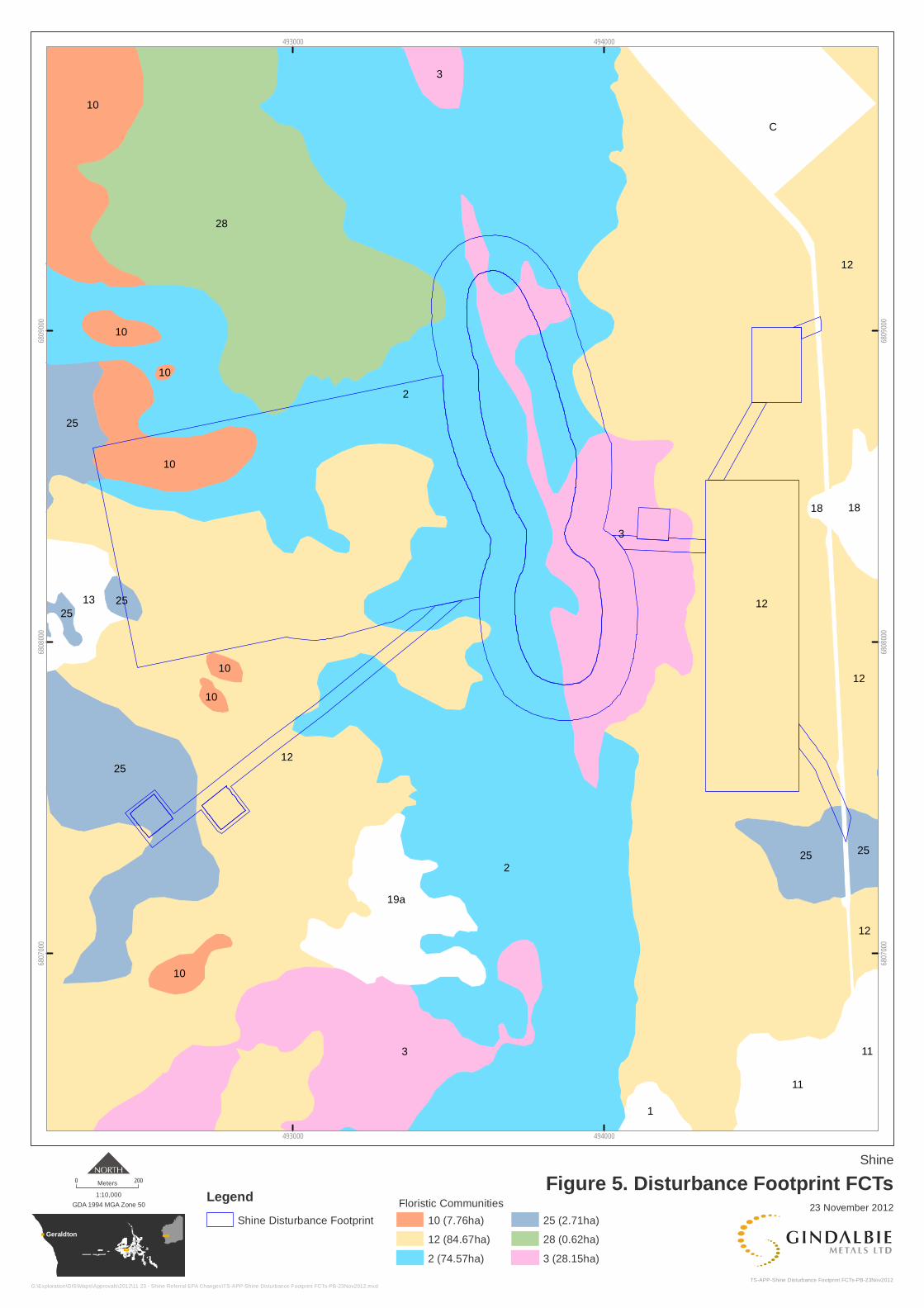
Regional flora mapping has been completed for KML and Gindalbie Metals Ltd (GBG) by Woodman Environmental Consultants (WEC, 2012). This data has also been used to assess the impacts of this proposal on the regional community. This survey identified two Floristic Community Types within the SIOP disturbance footprint. A description of each of the FCT is outlined in Table 9 and in Figure 5.
It should be noted that regional mapping is based on tenement boundaries, and therefore should not be considered as a definitive area for each floristic community type. This is particularly important when considering the FCT’s located in the Minjar/Gnows Nest vegetation complexes Banded Ironstone Formation Priority 1 Ecological Community (referred to as ‘the PEC’). FCT’s 2 and 3 represent approximately 4,184.86ha of the regional survey area inside the buffer zone of the PEC.
SHINE IRON ORE PROJECT ENVIRONMENTAL REVIEW DOCUMENT P a g e | 19
Table 9 Floristic Community Types (FCT) impacted by SIOP Disturbance Footprint
FCT Regional FCT Area Total (ha)
Area (ha) Impacted by SIOP
% Impacted by SIOP
Description of FCT (Woodman, 2012)
Possible Minjar Gnows Nest PEC FCT2 3671.31 74.57 2.03% Tall shrubland to tall open shrubland of mixed Acacia species, including Acacia ramulosa var.
ramulosa, A. exocarpoides, A. aneura and A. tetragonophylla over mid open shrubland to mid sparse shrubland of mixed species including Eremophila clarkei, E. larobei subsp. latrobei, Hibbertia arcuata, Philotheca brucei subsp. brucei and Philotheca sericea on red-brown silty loams or clay loams on flats to upperslopes with ironstone (BIF) or granite outcropping
FCT3 813.50 28.15 3.40% Tall shrubland to tall open shrubland of mixed Acacia species, including Acacia ramulosa var. ramulosa, A. aulacophylla, and A. aneura over mid open shrubland to mid sparse shrubland of mixed species including Eremophila latrobei subsp. latrobei, E. glutnosa, Micromyrtus trudgenii, Mirbelia bursarioides ms, Philotheca brucei subsp. brucei, Philotheca sericea and Prostanthera patens over low isolated clumps of forbs of Stylidium longibracteatum on red-brown or light brown clay loams or silty clay loams o flats to crests with ironstone (BIF) or granite outcropping
Sub Total
4,484.81 102.72 2.29%
Other FCTs FCT 10 3033.97 7.76 0.26 Tall closed shrubland to tall open shrubland of mixed Acacia species dominated by Acacia assimilis
subsp. assimilis over mid open shrubland to mid sparse shrubland of mixed species including Aluta aspera subsp. hesperia, Eremophila latrobei subsp. latrobei and Philotheca sericea on red or red-brown silty clay loam or clay loam with ironstone gravel on flats to crests (primarily midslopes)
FCT 12 2416.17 84.67 3.50 Tall shrubland of mixed Acacia species including Acacia ramulosa var. ramulosa, A. sibina and A. effusifolia over mid open shrubland to mid sparse shrubland of mixed species including Aluta aspera subsp. hesperia, Philotheca brucei subsp. brucei, Eremophila latrobei subsp. latrobei, E. clarkei, E. forrestii subsp. forrestii over low isolated clumps of ferns of Cheilanthes sieberi over low isolated clumps of grasses of Monachather paradoxus on red, brown or red-brown silty clay loam or silty loam on flats to lowerslopes

SHINE IRON ORE PROJECT ENVIRONMENTAL REVIEW DOCUMENT P a g e | 20
Note: 0.29ha is mapped as disturbed as it is on the existing Minjar Haul Road and therefore is not included in the above total area.
FCT Regional FCT Area Total (ha)
Area (ha) Impacted by SIOP
% Impacted by SIOP
Description of FCT (Woodman, 2012)
FCT 25 3040.00 2.71 0.09 Tall shrubland to tall open shrubland of mixed species including Acacia ramulosa var. ramulosa, A. tetragonophylla, A. effusifolia and Hakea recurva subsp. recurva with low isolated clumps of trees of Callitris columellaris and/or Eucalyptus spp. over low sparse shrubland of mixed species including Eremophila georgei over low isolated clumps of grasses of Monachather paradoxus on red or orange sandy loam or clay loam on flats to midslope
FCT 28 1492.60 0.62 0.04 Tall shrubland to tall open shrubland of Acacia species including Acacia ramulosa var. ramulosa, A. tetragonophylla and A. burkittii over mid sparse shrubland of species including Eremophila clarkei, E. oldfieldii, Solanum lasiophyllum, Scaevola spinescens, and Dodonaea inaequifolia on red or red-brown clay loam or silty clay loam with ironstone gravel on flats to midslopes of low hills
Sub Total
9982.74
95.76
0.96%
Total 14467.55 198.48 1.37%
Geraldton
2
12
12
2
3
3
28
C
25
12
10
11
10
19a
12
25
13
25
3
18
1
11
10
12
25
10
25
10
25
10
18
10
493000
493000
494000
494000
6807
000
6807
000
6808
000
6808
000
6809
000
6809
000
Shine
Figure 5. Disturbance Footprint FCTs0 200Meters
GDA 1994 MGA Zone 50
1:10,000
TS-APP-Shine Disturbance Footprint FCTs-PB-23Nov2012
23 November 2012
G:\Exploration\GIS\Maps\Approvals\2012\11 23 - Shine Referral EPA Changes\TS-APP-Shine Disturbance Footprint FCTs-PB-23Nov2012.mxd
Legend
Shine Disturbance Footprint 10 (7.76ha)
12 (84.67ha)
2 (74.57ha)
25 (2.71ha)
28 (0.62ha)
3 (28.15ha)
Floristic Communities
SHINE IRON ORE PROJECT ENVIRONMENTAL REVIEW DOCUMENT P a g e | 22
Threatened and Priority Ecological Communities
No Threatened Ecological Communities (TEC) pursuant to Commonwealth legislation or listed by DEC were recorded within the disturbance footprint (Botanica Consulting, 2012).
The SIOP disturbance footprint is located within the PEC that encompasses the Central Tallering Land System, the land area between Mt Gibson and Tallering Peak (Botanica Consulting, 2012). As identified by Markey and Dillon (Flora and Vegetation survey of the Banded Ironstone formations of the Yilgarn Craton: Central Tallering Land system, 1998), the PEC (including the 30 km buffer zone) covers an area of 283,000 ha (Botanica Consulting, 2012).
The Woodman regional mapping (2012) and the detailed mapping undertaken by Botanica Consulting in 2012 identified that FCT’s 2 and 3 are vegetation types consistent with the PEC. It should be noted that the regional mapping does not cover the entirety of the PEC buffer zone, (only approximately 15.87%). Neither does the regional survey encapsulate all sampling quadrants originally used to clarify the communities as PEC by Markey & Dillon (Borger, 2012). To obtain a conservative estimate of the amount of PEC within the buffer zone, FCTs 2 and 3 were extrapolated over the buffer zone based on the percentage maintained within the Woodman survey area. This resulted in a total of 26,371.17 ha identified as potentially occurring within the PEC buffer zone. In relation to the shine disturbance footprint, the project would impact 0.19% of this estimated total PEC area, and therefore would be considered insignificant (Borger 2012).
This estimation technique is consistent when taking into account Banded Iron Formations (BIF’s) known to occur within the PEC buffer zone (being a value of approximately 21,595 ha). When considering that the PEC is associated with the BIF’s and associated washaways and lower slope, it can be considered that the estimated impact is conservative.
Groundwater Dependant Vegetation
No groundwater dependant vegetation occurs at SIOP; groundwater in the development envelope is approximately 50-60 meters below ground level (Borger 2012, personal communication). Negligible impact will occur on any surface water dependant vegetation from the construction and operation of SIOP (Borger 2012, personal communication). No surface water dependant vegetation occurs near the minor ephemeral drainage lines within the disturbance footprint (Borger 2012, personal communication).

SHINE IRON ORE PROJECT ENVIRONMENTAL REVIEW DOCUMENT P a g e | 23
Management Strategies
The management strategies to avoid and/or mitigate the potential impacts of SIOP on flora will be met by implementing the Flora and Weeds Management section of the SIOP Environmental Management Plan. These are briefly summarised below:
Priority Flora shall be protected at all times, except in accordance with an approved Ground Disturbance Permit.
A Conservation Significant Flora Identification Guide shall be made available to all personnel managing clearing activities.
Mature trees shall be marked with pink flagging tape and avoided where practicable.
Disturbance to riparian vegetation shall be avoided where practicable.
No burning of cleared vegetation shall be permitted.
The following requirements shall be met in relation to weed management:
Non endemic plants shall not be permitted on site unless authorised in writing by the Environmental Manager.
Known populations of weeds within the Project area shall be demarcated on a site plan.
A Weed Identification Guide has been developed and shall be made available to site personnel.
The site induction shall include vehicle hygiene requirements and shall be attended by all employees/contractors.
All vehicles and mobile equipment shall be inspected and cleaned of vegetation, mud and soil prior to entry to site. The Vehicle and Mobile Equipment Weed Inspection Form shall be completed for all vehicles entering site. Completed forms shall be maintained on site files by the contractor and the Site Environmental Advisor for audit and inspection purposes.
Quarantine areas encompassing known weed infestations shall be established and demarcated by the Site Environmental Advisor to prohibit vehicular access thereby reducing the potential for vegetative and seed dispersal. Any quarantine areas shall be clearly demarcated and signed.
Any equipment or vehicle considered to have been working in a weed risk area shall be cleaned down, and a Vehicle and Mobile Equipment Weed Inspection Form completed before the equipment is remobilised to other parts of the Project area. Weed washdown water and soil shall be directed to a sump and buried at a minimum depth of 300 mm below the natural land surface.
GBG consider that SIOP will be unlikely to have a significant impact on flora.
5.2 Potential Impacts on Fauna Assemblage
EPA Objective: Maintain the diversity, geographic distribution and productivity of terrestrial and subterranean fauna at species and ecosystem levels through the avoidance or management of adverse impacts and the improvement of knowledge.
Project Impacts
SHINE IRON ORE PROJECT ENVIRONMENTAL REVIEW DOCUMENT P a g e | 24
Fauna
Impacts upon the fauna assemblage as a whole are expected to be insignificant as fauna are generally widespread within Vegetation Substrate Associations (VSAs) in the region (BCE, 2012). VSAs provide useful information in which to understand the major fauna habitat types present and to assess the likelihood of conservation significant species being present in the area. A total of 30 conservation significant vertebrate species and four conservation significant invertebrate species were considered likely to occur within the development envelope (BCE, 2012). However impacts upon the majority of the conservation significant species are expected to be insignificant because their habitat is not restricted or they are not residents within the SIOP disturbance footprint (BCE, 2012).
Eleven conservation significant fauna species were recorded during the field survey that was known to occur within the region. Of these, potential impacts are likely to occur to Malleefowl and Shield-backed Trapdoor Spider.
Malleefowl (federally and state listed). One active mound has been recorded, and one bird observed, within the disturbance footprint (BCE, 2012); Figure 2. Since this survey another active mound was identified during exploration activities. Direct impact, including clearing (removal of potential habitat), vehicle interaction and increased traffic, and indirect impacts such as increased feral animals, restrictions through habitat linkages and human interaction is anticipated to be minor. There is extensive suitable habitat on the plains around the SIOP area, away from mining and vehicle activity (BCE, 2012).
Shield-backed Trapdoor Spider (state listed). These were observed to be restricted to the slopes of ridges within the disturbance footprint (BCE, 2012); Figure 3. A population of approximately 21,870 spiders is expected within the disturbance footprint, whilst an estimated population size of 81,000 spiders within likely occupied habitat in the Shine vicinity (BCE, 2012). Impact is expected to be minor (BCE, 2012).
Western Spiny Tailed Skink (federally listed species) are known to occur at the southern extremity of the development, however are located outside of the disturbance footprint and not likely to be impacted by SIOP.
Subterranean Fauna
Dewatering of ground water from the open pit, mining of the sub-surface material and abstraction of ground water from the minesite bores could potentially impact on subterranean fauna (stygofauna and troglofauna), if any (Rockwater, 2012).
Stygofauna sampling undertaken within the disturbance footprint yielded one site with potential stygofauna (Nematodes), however due to the limited taxanomic framework available it can only be identified to its Phylum level (Rockwater, 2012). Furthermore, in accordance with EPA Guidance Statement No.54a (Sampling methods and survey considerations for subterranean fauna) it is suggested there there is no requirement to identify Nematoda to lower taxonomic levels for environmental impact assessment purposes (Rockwater, 2012).
Given that both aquatic and stygal forms of nematode were identified at SIOP, it seems unlikely that it is recorded as stygobitic. It is anticipated that a permanent freshwater water
SHINE IRON ORE PROJECT ENVIRONMENTAL REVIEW DOCUMENT P a g e | 25
body will establish in the open pit void following closure. Associated potential impacts of this to fauna may include drowning and the proliferation of native and/or feral species.
Based on current study results it is considered unlikely that SIOP will impact on subterranean fauna (Rockwater, 2012).
Management Strategies
These impacts will be managed through supporting mitigating strategies, outlined below, and as further detailed within the Fauna Management section of the SIOP Environmental Management Plan. Key management measures include, but are not limited to;
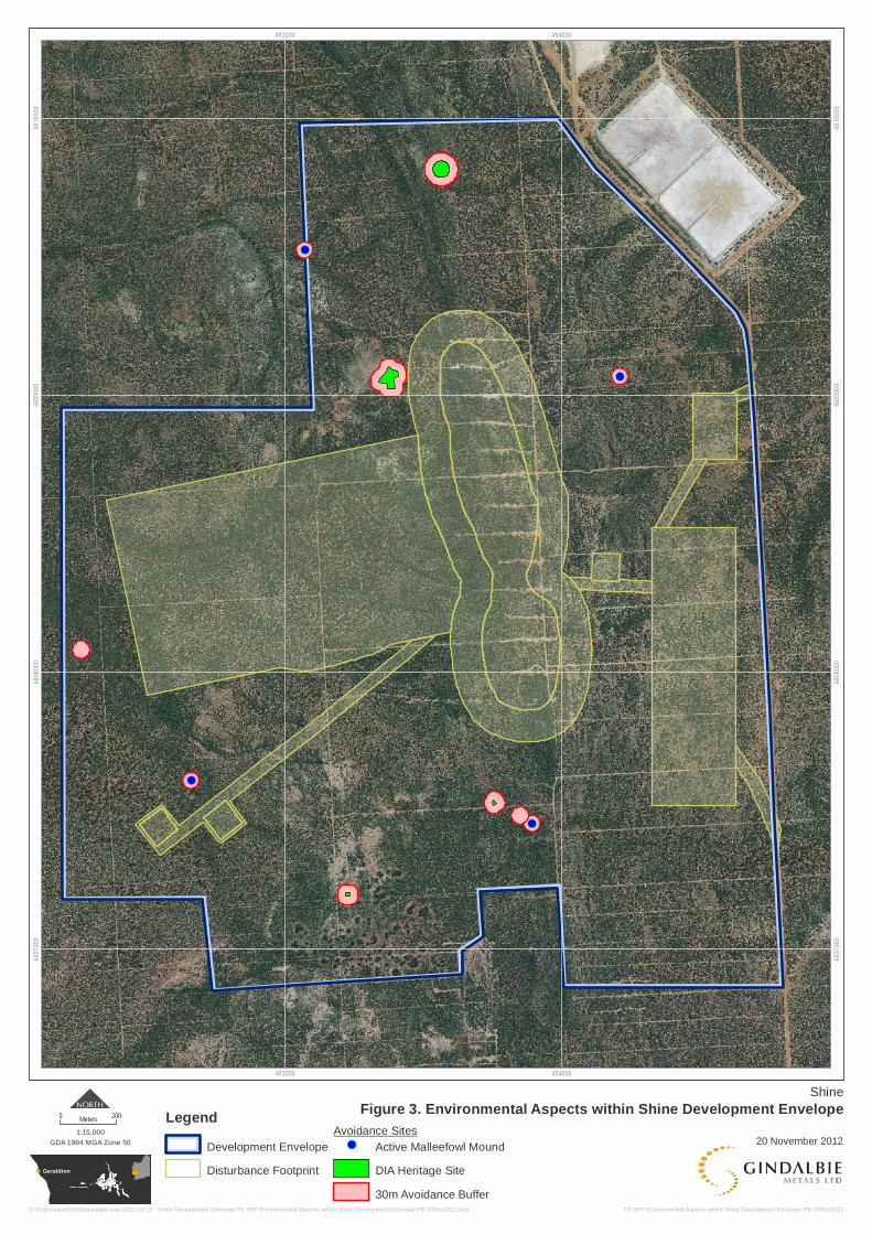
Where GBG is advised of the location of significant fauna and habitats, these shall be taken into account during Project construction and operation activities with the objective of avoiding these areas. These are identified as Avoidance Sites and will include a 30m buffer to ensure its avoidance (Figure 2 and 3). This is also further managed through the Approvals Request and Ground Disturbance process.
Foundation holes, excavations and trenches, wherever practicable, shall be covered, fenced, barricaded or bunded to prevent injury to fauna.
Feeding and / or capture of native fauna or feral animals is not permitted on site unless this occurs in accordance with a GBG approved fauna study or management exercise.
Site inductions shall address fauna protection requirements.
Pets, off-road recreational vehicles and firearms shall not be permitted on site.
Disturbed areas shall be rehabilitated as soon as practicable to facilitate fauna habitat restoration.
Foundation holes, excavations, trenches and turkeys nests shall be constructed with a means of fauna egress.
Observations of feral species shall be reported to the Site Environmental Advisor.
Prior to any ground disturbances occurring in the SIOP area, an internal Ground Disturbance permit will be sought.
Compliance with the Shield-Backed Trapdoor Spider Management and Monitoring Procedure.
Results of the survey and the effective implantation of the management measures indicate that SIOP will unlikely to have a significant impact on conservation significant fauna species.
5.3 Potential Impacts on Groundwater
EPA Objective: Maintain the quality and quantity of groundwater so that existing and potential uses, including ecosystem maintenance are protected.
SHINE IRON ORE PROJECT ENVIRONMENTAL REVIEW DOCUMENT P a g e | 26
Project Impacts
Rockwater (2012), as part of the Groundwater Impact Assessment, constructed a groundwater flow model of the proposal to assess the impacts of pit dewatering, and the nature of the final void. The model was calibrated to drawdowns measured during the pumping tests on the two production bores. The results of the modelling indicated the following:
Dewatering flow rates are indicated to peak at about 3,900 kL/d approximately a year after the start of mining, but will generally be less than 2,000 kL/d (Rockwater, 2012).
Drawdowns during dewatering will extend up to 700 m east and west of the pits, and 800 to 1,000 m to the north and south. They will not extend as far as the pits at the Silverstone and Minjar Gold Projects (Rockwater, 2012).
The final pit void will form a groundwater sink, with water level in the pits at about 317 m AHD, compared to the pre-mining level of about 345 m AHD. The salinity of water in the void will gradually increase, but this will have no impact on the surrounding groundwater as there will be no flow from the void (Rockwater, 2012).
Water pumped during pit, drain and abstraction bore dewatering will be used for SIOP construction and operations and is depicted in the Water Balance Modelling conducted by GBG (Table 10). It is anticipated that total supply (comprising of water from sump pits, abstraction bores and drains) will be used entirely for SIOP total demand over the periods of construction and operation (Table 10). There will be no water being discharged to the environment and regional water quality will not be impacted by pit, drain and abstraction bore dewatering.
SHINE IRON ORE PROJECT ENVIRONMENTAL REVIEW DOCUMENT P a g e | 27
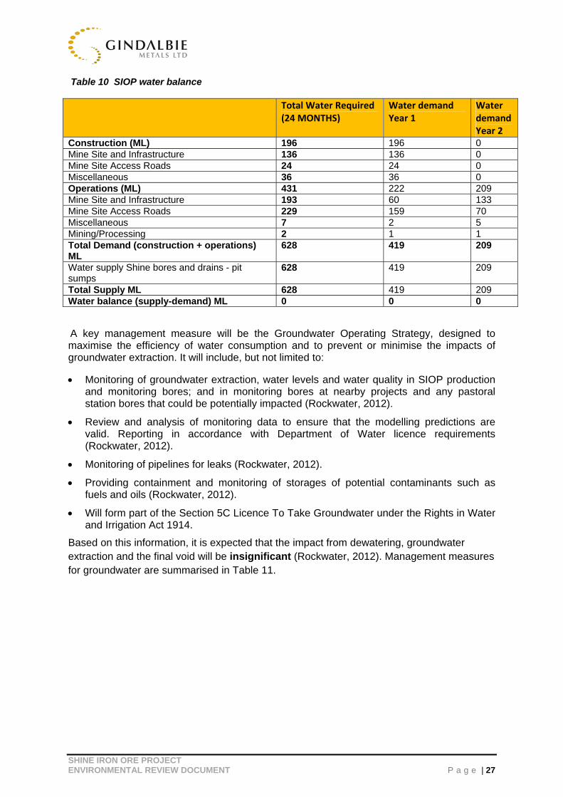
Table 10 SIOP water balance
A key management measure will be the Groundwater Operating Strategy, designed to maximise the efficiency of water consumption and to prevent or minimise the impacts of groundwater extraction. It will include, but not limited to:
Monitoring of groundwater extraction, water levels and water quality in SIOP production and monitoring bores; and in monitoring bores at nearby projects and any pastoral station bores that could be potentially impacted (Rockwater, 2012).
Review and analysis of monitoring data to ensure that the modelling predictions are valid. Reporting in accordance with Department of Water licence requirements (Rockwater, 2012).
Monitoring of pipelines for leaks (Rockwater, 2012).
Providing containment and monitoring of storages of potential contaminants such as fuels and oils (Rockwater, 2012).
Will form part of the Section 5C Licence To Take Groundwater under the Rights in Water and Irrigation Act 1914.
Based on this information, it is expected that the impact from dewatering, groundwater extraction and the final void will be insignificant (Rockwater, 2012). Management measures for groundwater are summarised in Table 11.
Total Water Required (24 MONTHS)
Water demand Year 1
Water demand Year 2
Construction (ML) 196 196 0 Mine Site and Infrastructure 136 136 0 Mine Site Access Roads 24 24 0 Miscellaneous 36 36 0 Operations (ML) 431 222 209 Mine Site and Infrastructure 193 60 133 Mine Site Access Roads 229 159 70 Miscellaneous 7 2 5 Mining/Processing 2 1 1 Total Demand (construction + operations) ML
628 419 209
Water supply Shine bores and drains - pit sumps
628 419 209
Total Supply ML 628 419 209 Water balance (supply-demand) ML 0 0 0
SHINE IRON ORE PROJECT ENVIRONMENTAL REVIEW DOCUMENT P a g e | 28
5.4 Rehabilitation and Mine Closure
EPA Objectives:
Ensure that closure and rehabilitation achieves stable, non-polluting and functioning landforms which are consistent with surrounding landscape and other environmental values; and
Ensure that self-sustaining native vegetation communities are returned after mining, which, in species composition and ecological function area close as possible to naturally occurring analogue sites.
Project Impacts
A Waste Rock Landform (WRL) Design and Closure Criteria study was undertaken by Soil Water Consultants in February 2012 to develop a rehabilitation closure framework for SIOP. The study addressed the following items:
Development of optimal Waste Rock Landform design parameters.
Development of a rehabilitation plan and preliminary completion criteria.
Recommendations for appropriate rehabilitation monitoring strategies.
Conceptual design and management for the SIOP disturbance footprint (including infrastructure, Waste Rock Landform, Run of Mine pad) details rehabilitation criteria to be complied with throughout the mining operations and post mining activities.
A Mine Closure Plan has been developed, in collaboration with Soil Water Consultants in June 2012, to provide a strategic plan and implementation framework for the successful and environmentally sustainable closure of SIOP, post-mining (Appendix G). The plan details all closure related aspects associated with mining and operations including the decommissioning of the mine site, mine pits, post-mine landforms and supporting infrastructure. The Mine Closure Plan identified three specific potential environmental impacts related to closure; being contamination, acid mine drainage and groundwater. These impacts are considered insignificant due to:
The stability and structural integrity of the overall mine pit design and final resting state, abandonement bund and WRL will be designed in accordance with standard industry methods.
Geochemical characterisation and leachate testing of waste rock materials have shown a low potential for mined material to release metals and metalloids. As a consequence, the risk of acid production from oxidation or acid and metalliferous drainage occurring within the WRL is considered negligible and will not pose a liability.
The plan requires the assessment of localised areas of contamination (i.e. contractor’s yard, ROM pad). Remediation, if required, shall be undertaken through excavation of contaminated materials and remediated through a bioremediation area. Treated material shall then be placed within the WRL and capped.
SHINE IRON ORE PROJECT ENVIRONMENTAL REVIEW DOCUMENT P a g e | 29
The final pit void will form a groundwater sink, with water level in the pits at about 317 m AHD, compared to the pre-mining level of about 345 m AHD. The salinity of water in the void will gradually increase, but this will have no impact on the surrounding groundwater as there will be no flow from the void, and the phreatic surface is very deep, therefore resulting in a very low likelihood of terrestrial groundwater dependent ecosystems occurring.
The environmental impacts of mine closure are negligible, due to the design, inert waste characterisation and low risk of contamination. The implementation of the Mine Closure Plan will not pose an unacceptable liability to the State.

SHINE IRON ORE PROJECT ENVIRONMENTAL REVIEW DOCUMENT P a g e | 30
5.5 Residual Impacts
Through the implementation of the management measures detailed in Table 11, GBG believe that the key environmental aspects of this proposal and its potential impacts can be effectively managed so that there is negligible residual impacts.
The project will be contained within a disturbance area of up to 200ha. A number of supporting environmental studies coupled with a detailed risk assessment already being undertaken has determined that all residual impacts are either considered to be low risk or unlikely to result in any significant impacts (Table 11).
An assessment against the offset principles has been completed and a completed Environmental Offsets Reporting Form is included as Appendix I.
Copies of the Management Plans/Procedures can be provided upon request.
SHINE IRON ORE PROJECT ENVIRONMENTAL REVIEW DOCUMENT P a g e | 31
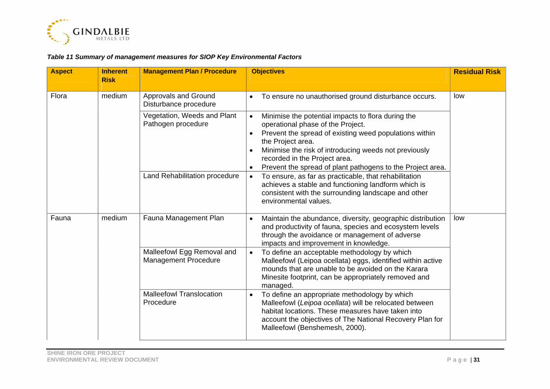
Table 11 Summary of management measures for SIOP Key Environmental Factors
Aspect Inherent Risk
Management Plan / Procedure Objectives Residual Risk
Flora medium Approvals and Ground Disturbance procedure
To ensure no unauthorised ground disturbance occurs. low
Vegetation, Weeds and Plant Pathogen procedure
Minimise the potential impacts to flora during the operational phase of the Project.
Prevent the spread of existing weed populations within the Project area.
Minimise the risk of introducing weeds not previously recorded in the Project area.
Prevent the spread of plant pathogens to the Project area.Land Rehabilitation procedure To ensure, as far as practicable, that rehabilitation
achieves a stable and functioning landform which is consistent with the surrounding landscape and other environmental values.
Fauna medium Fauna Management Plan
Maintain the abundance, diversity, geographic distribution
and productivity of fauna, species and ecosystem levels through the avoidance or management of adverse impacts and improvement in knowledge.
low
Malleefowl Egg Removal and Management Procedure
To define an acceptable methodology by which Malleefowl (Leipoa ocellata) eggs, identified within active mounds that are unable to be avoided on the Karara Minesite footprint, can be appropriately removed and managed.
Malleefowl Translocation Procedure
To define an appropriate methodology by which Malleefowl (Leipoa ocellata) will be relocated between habitat locations. These measures have taken into account the objectives of The National Recovery Plan for Malleefowl (Benshemesh, 2000).
SHINE IRON ORE PROJECT ENVIRONMENTAL REVIEW DOCUMEN P a g e | 32
Aspect Inherent Risk
Management Plan / Procedure Objectives Residual Risk
Malleefowl Monitoring and Management Procedure
To minimise, to as low as reasonably practicable, the impact of mining activities on the Malleefowl (Leipoa ocellata) by identifying and implementing a range of management and monitoring measures. These measures have taken into account the objectives of The National Recovery Plan for Malleefowl.
Feral Animal Management Plan
Avoiding, minimising and mitigating impacts on fauna.
Groundwater medium Groundwater Operating Strategy (In Development)
To maintain the quality and quantity of water so that existing environmental values are protected and relevant licenses and legislation are met.
low
Mine closure and Rehabilitation
medium Mine Closure Plan
Identifying aspects related to decommissioning and closure that may impact the environment and be of a concern to regulatory agencies.
Providing a basis for consultation with regulatory and identified stakeholders regarding post-mining land uses and the development of agreed completion criteria.
Developing management strategies to minimise impacts and site closure requirements to be implemented and confirming completion criteria are met.
low
Waste Rock Landform Design and Preliminary Closure criteria
Development of optimal Waste Rock Landform design parameters
SHINE IRON ORE PROJECT ENVIRONMENTAL REVIEW DOCUMENT P a g e | 33
6 CUMULATIVE IMPACTS
6.1 Overview
Cumulative impacts were assessed on readily available data, being KML and GBG datasets (Table 12), due to the lack of publicly available data from mining operations in the immediate region. In addition, comparable mining activities (such as iron ore on BIF ridges) were not possible as adjacent operations undertake gold mining activities.
KML has data coverage over 81,781 km2 based on regional exploration and mining activities. This includes the Greater Karara Iron Ore Project and SIOP. Although this dataset information is not definitive, it does provide suitable estimated coverage for an assessment of cumulative impacts.
SIOP is a low scale activity; with a disturbance footprint of approximately 200 ha, operating 12 hours a day (during day shift only) with a Life of Mine (LOM) expected to be approximately 3 years only (maximum of 5 years). KML’s Greater Karara Iron Ore Project (MIOP and KIOP combined) has a disturbance footprint of approximately 2403 ha. No data was available regarding the disturbance footprint of other mine sites in the SIOP region.
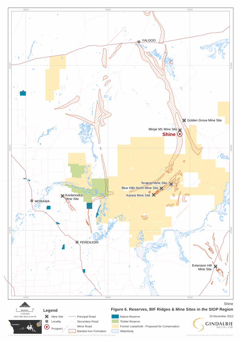
Pastoral and mining are the dominant land uses in the SIOP area. The closest mining operations to SIOP are Minjar Gold (5 km to the north of SIOP), Golden Grove (12 km to the northeast of SIOP), Greater Karara Iron Ore Project (30 km to the southwest of SIOP), Koolanooka (85 km to the southwest of SIOP) and Extension Hill (95 km to the southeast of SIOP) (Figure 6).
SIOP is situated on Badja Station, an area of 113,582 hectares owned and managed by GBG. DEC manage pastoral leases for the purposes of conservation, approximately 70 km to the southwest of SIOP (Figure 6).
GBG considers the main cumulative impacts will be on BIF ridges, flora and fauna in the region. Impacts from these aspects are discussed in detail within this document.
Geraldton
!H
")
")
")
"D
"D
"D
"D
"D
"D
"DTerapod Mine Site
Blue Hills North Mine Site
Karara Mine Site
Minjar M1 Mine Site
KoolanookaMine Site
Golden Grove Mine Site
Extension HillMine Site
MORAWA
YALGOO
PERENJORI
Shine
400000
400000
450000
450000
500000
500000
6750
000
6750
000
6800
000
6800
000
6850
000
6850
000
Shine
Figure 6. Reserves, BIF Ridges & Mine Sites in the SIOP Region
23 November 2012
TS-APP-Reserves & Mine Sites in the SIOP Area-PB-23Nov2012
0 10kilometers
GDA 1994 MGA Zone 50
1:700,000
G:\Exploration\GIS\Maps\Approvals\2012\11 23 - Shine Referral EPA Changes\TS-APP-Reserves & Mine Sites in the SIOP Area-PB-23Nov2012.mxd
Legend
"D Mine Site
") Locality
!H Prospect
Principal Road
Secondary Road
Minor Road
Banded Iron Formation
Nature Reserve
Timber Reserve
Former Leasehold - Proposed for Conservation
Waterbody

SHINE IRON ORE PROJECT ENVIRONMENTAL REVIEW DOCUMENT P a g e | 35
6.2 Data Limitations and Constraints
It is important to note that surveys, and ultimately survey results, will entail limitations notwithstanding careful planning and design. These include;
Cumulative impacts based on readily available data. Therefore, some impacts identified in Table 12, will be higher than actual, namely Priority Flora, the PEC, Mallefowl, Habitats (prospective and potential);
Estimates based on extrapolation of existing data;
Data is under- represented as they only detail what has been captured through surveyed areas undertaken by GBG/KML, which constitute a small proportion of the region; and
Distribution of vegetation communities outside of the study area is not known (Botanica
Consulting, 2012).

SHINE IRON ORE PROJECT ENVIRONMENTAL REVIEW DOCUMENT P a g e | 36
Table 12 Cumulative impact of SIOP on flora and fauna
Item Regional Total Point Locations Shine Impact Cumulative Impact (GKIOP + Shine)
Percentage Shine Impact on Surveyed Region
Percentage Cumulative Impact on Surveyed Region
FLORA
Beard Vegetation Association: Yalgoo 202
448,529.32ha
142.91ha 142.91ha 0.03% 0.03%
Beard Vegetation Association: Yalgoo 420
830,931.34ha 55.86ha 104.74ha 0.001% 0.012%
FCT 2 3671.31ha - 74.57ha 97.63ha 2.00% 2.65%
FCT 3 813.50ha - 28.15ha 28.15ha 3.46% 3.46%
Drummondita fulva (P3)
14574 907 4,978 plants 5,016 plants 34.15% 34.41%
Micromyrtus trudgenii (P3)
17765 892 1,230 plants 1,902 plants 6.92% 10.70%
Calytrix unicata (P3)
662 120 3 plants 3 plants 0.45% 0.45%
LANDFORMS
BIF Ridge Area
293,921ha - 194.47ha 604.07ha 0.06% 0.20%
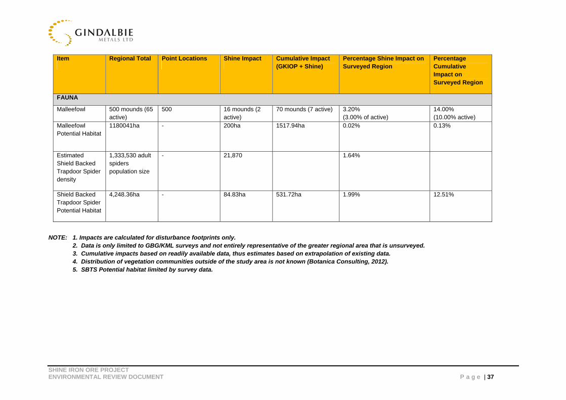
SHINE IRON ORE PROJECT ENVIRONMENTAL REVIEW DOCUMENT P a g e | 37
Item Regional Total Point Locations Shine Impact Cumulative Impact (GKIOP + Shine)
Percentage Shine Impact on Surveyed Region
Percentage Cumulative Impact on Surveyed Region
FAUNA
Malleefowl 500 mounds (65 active)
500 16 mounds (2 active)
70 mounds (7 active) 3.20% (3.00% of active)
14.00% (10.00% active)
Malleefowl Potential Habitat
1180041ha - 200ha 1517.94ha 0.02% 0.13%
Estimated Shield Backed Trapdoor Spider density
1,333,530 adult spiders population size
- 21,870 1.64%
Shield Backed Trapdoor Spider Potential Habitat
4,248.36ha - 84.83ha 531.72ha 1.99% 12.51%
NOTE: 1. Impacts are calculated for disturbance footprints only. 2. Data is only limited to GBG/KML surveys and not entirely representative of the greater regional area that is unsurveyed.
3. Cumulative impacts based on readily available data, thus estimates based on extrapolation of existing data. 4. Distribution of vegetation communities outside of the study area is not known (Botanica Consulting, 2012). 5. SBTS Potential habitat limited by survey data.
SHINE IRON ORE PROJECT ENVIRONMENTAL REVIEW DOCUMEN P a g e | 3 8
6.3 BIF Ridges
SIOP is located on a Banded Iron Formation (BIF) ridge (Figure 5). BIF ridges have been identified as significant by the Department of Environment and Conservation (DEC) as they often support fauna and flora populations and communities of high environmental and conservation significance (including endemic species) as well as indigenous heritage sites (DEC, 2007a) (Figure 6). In 2007, the Department of Industry and Resources (DoIR) demarcated the extent of BIF in the Mid-West region and determined that the total BIF in the region is 293,921 ha (DoIR, 2008).
DEC’s 2007 published Report on the “Banded Ironstone Formation Ranges of the Midwest and Goldfields”, classifies the BIF ridge area that the SIOP is located upon of lower biodiversity value and is located outside of any proposed conservation estate (DEC,2007b).
Due mainly to the low scale of SIOP, best practice management measures in place (Table 11), and isolation from any BIF ridges of high biodiversity value (Figure 6), GBG considers that any cumulative impacts of SIOP on the flora and fauna populations and communities, and heritage sites, of BIF ridges and conservation estates within the region as unlikely to be significant. There are occurrences of BIF ranges outside the SIOP region (Figure 7). The BIF mapping is based on the Western Australian Geological Survey.

Geraldton
480000
480000
500000
500000
520000
520000
6760
000
6760
000
6780
000
6780
000
6800
000
6800
000
6820
000
6820
000
Shine
Figure 7. Regional Distribution of FCTs 2 and 30 5kilometres
GDA 1994 MGA Zone 50
1:250,000
TS-APP-Regional Distribution of FCTs 2 and 3 with BIF-PB-23Nov2012
23 November 2012
G:\Exploration\GIS\Maps\Approvals\2012\11 23 - Shine Referral EPA Changes\TS-APP-Regional Distribution of FCTs 2 and 3 with BIF-PB-23Nov2012.mxd
Legend
Shine Disturbance Footprint
Greater KIOP Footprint
Minjar/Gnows Nest PEC Area
Extent of Woodman FCT Mapping
Banded Iron Formations
FCT 2
FCT 3
KARARA
BHN
TERAPOD
SHINE
SHINE IRON ORE PROJECT ENVIRONMENTAL REVIEW DOCUMENT P a g e | 40
6.4 Flora and Fauna Flora
Priority Flora
Calytrix unicata
Flora surveys identified a total of 662 Calytrix unicata within the regional area in which SIOP has a total impact of 3, approximately 0.45%. To date GKIOP has impacted 0 plants therefore the cumulative impact remains 0.45% of 662 plants (Table 12).
Drummondita fulva
A total of 14,574 Drummondita fulva recorded in the regional area in which SIOP has a total impact of 4,978, approximately 34.15%. To date GKIOP has impacted 38 plants therefore the cumulative impact to 5,016, approximately 34.41% of the total 14,574 plants (Table 12). Although the SIOP will have a cumulative impact of 34.41% of plants known within surveys undertaken by KML and GBG, it is unlikely to have a significant impact on the total population. This is due to; known habitat outside of the survey areas, large regional extent and key rehabilitation species for final landforms.
Micromyrtus trudgenii
There are a total of 17,765 Micromyrtus trudgenii recorded in the regional area in which SIOP has a total impact of 1,230 plants, approximately 6.92%. To date GKIOP has impacted 672 therefore the cumulative impact to 1,902 plants, approximately 10.70% of the total 17,765 plants (Table 12). The Priority Flora species impacted as a result of SIOP will be noted as keystone species; with seeds collected from known distribution areas within SIOP during construction and operation. Seed collected will be utilised during rehabilitation of the waste rock landform, resulting in a net zero impact post-mine life.
Priority Ecological Community
The cumulative impact of the SIOP and GKIOP can be considered to be unlikely to be significant as a majority of GKIOP is outside of the 30km buffer of the PEC. A small section of MIOP (being 23.06ha) is within the buffer area, however intensive flora surveys undertaken at GKIOP have identified these ecological communities are more closely associated with the (Midwest 2: Blue Hills (Mount Karara/Mungada Ridge/Blue Hills) vegetation complexes (banded ironstone formation)) PEC. Based on this information it can be assumed that GKIOP is not associated with the PEC and therefore there is no cumulative impact from the ground disturbance of GKIOP and SIOP.
Shield Backed Trapdoor Spider
A Shield-backed Trapdoor Spider (The Spider) population of approximately 21,870 is expected within the SIOP disturbance footprint, with an estimate of 28.27% of likely occupied habitat and 27% of the population size to be potentially impacted within the disturbance footprint (BCE, 2012) (Table 13).

SHINE IRON ORE PROJECT ENVIRONMENTAL REVIEW DOCUMENT P a g e | 4 1
Table 13 Estimated population size at Shine
Average number of burrows per ha
Extent of occupied
habitat (ha)
Extent of occupied habitat
disturbance footprint
Percentage Impact on
Occupied habitat
Estimated population size across Shine
(ha)
Estimated population size
within disturbance
footprint
Percentage Impact on Population
Size
270 300 84.83 28.27% 81,000 21,870 27%
1. Assumption of 1 adult burrow per ha
Surveys undertaken for The Spider in the Greater Karara Iron Ore Project region indicate that this species is abundant both in and outside of the impact areas, and therefore potential impacts are not considered to be significant (BCE, 2011). The average abundance of spider burrows per hectare of suitable habitat in the KIOP area was calculated as being approximately 297 burrows per hectare of suitable habitat (BCE, 2011). This translates to between 20,000 and 230,000 spiders per ridge, depending on its size (BCE, 2011, Table 14) and an approximate regional population of 1,333,530 adult population. Based on these numbers the potential impact to the regional population of Shield-backed Trapdoor Spiders from the SIOP disturbance footprint is approximately 1.64% (Table 12).

SHINE IRON ORE PROJECT ENVIRONMENTAL REVIEW DOCUMENT P a g e | 4 2
Table 14 Extent of probable occupied habitat and estimated population size across ridges surveyed.
Site Extent of probable habitat (ha)
Average number of burrows per ha across suitable habitat
Estimated adult spiders population size
Karara 530 297 157,410
Mungada 770 297 228,690
Shine 300 297 89,100
Terapod 70 297 20,790
Blue Hills 130 297 38,610
Spyder 120 297 35,640
Johnny's 350 297 103,950
Termination Ridge 310 297 92,070
Onga 130 297 38,610
Aroha North 560 297 166,320
Aroha South 210 297 62,370
Hippo 240 297 71,280
Lodestone 770 297 228,690
TOTAL 4460 297 1,333,530
BCE (2011) completed a regional review of habitat for the spider and estimated that the Spider occupies approximately 4460ha of probable habitat over the various Karara and GBG tenements and Projects. Based on an impact of 84.83ha for SIOP, and an anticipated impact from GKIOP of 352ha of probable habitat; the cumulative impact is 531.72ha. The percentage cumulative impact on the region is 12.5% (Table 12).
The Spider is known to have a wide distribution and is found on most BIF Ridges in the Mid-West and Yilgarn regions. The estimated population sizes are only based on surveys undertaken on GBG and KML mining and exploration leases, therefore the populations across the region are expected to be larger than stated above. Based on these results it is anticipated that the SIOP is unlikely to have a significant impact on the regional population of The Spider.
Malleefowl
Malleefowl Mounds
Two active and 20 inactive Malleefowl mounds were recorded in the SIOP development envelope, with one of the active mounds located within the disturbance footprint (in January 2012 it was considered likely to contain eggs) (BCE, 2012). An adult Malleefowl was also recorded in the vicinity of this active mound (BCE, 2012). Fifteen inactive mounds were found within the SIOP disturbance footprint (BCE, 2012).
SHINE IRON ORE PROJECT ENVIRONMENTAL REVIEW DOCUMENT P a g e | 43
There are a total of 500 Malleefowl mounds recorded in the regional mapping area in which SIOP has a total impact of 16 mounds, or approximately 3.20%. Incorporating the impactof GKIOP (being 54 mounds), the cumulative impact is 70 mounds or approximately 14%. (Table 12)
The number of mounds is based on surveys and opportunistic sightings, and therefore it is expected that the total number of mounds far exceeds this value. As an example, KML engaged The Malleefowl Presentation Group, to survey a 1,200ha area of vegetation on Baja Station in June 2012. The survey identified 47 mounds of which 11 showed recent Malleefowl activity (Malleefowl Presentation Group, 2012). Such a density of mounds, being 4 mounds per 100ha, would be fairly consistent through the region.
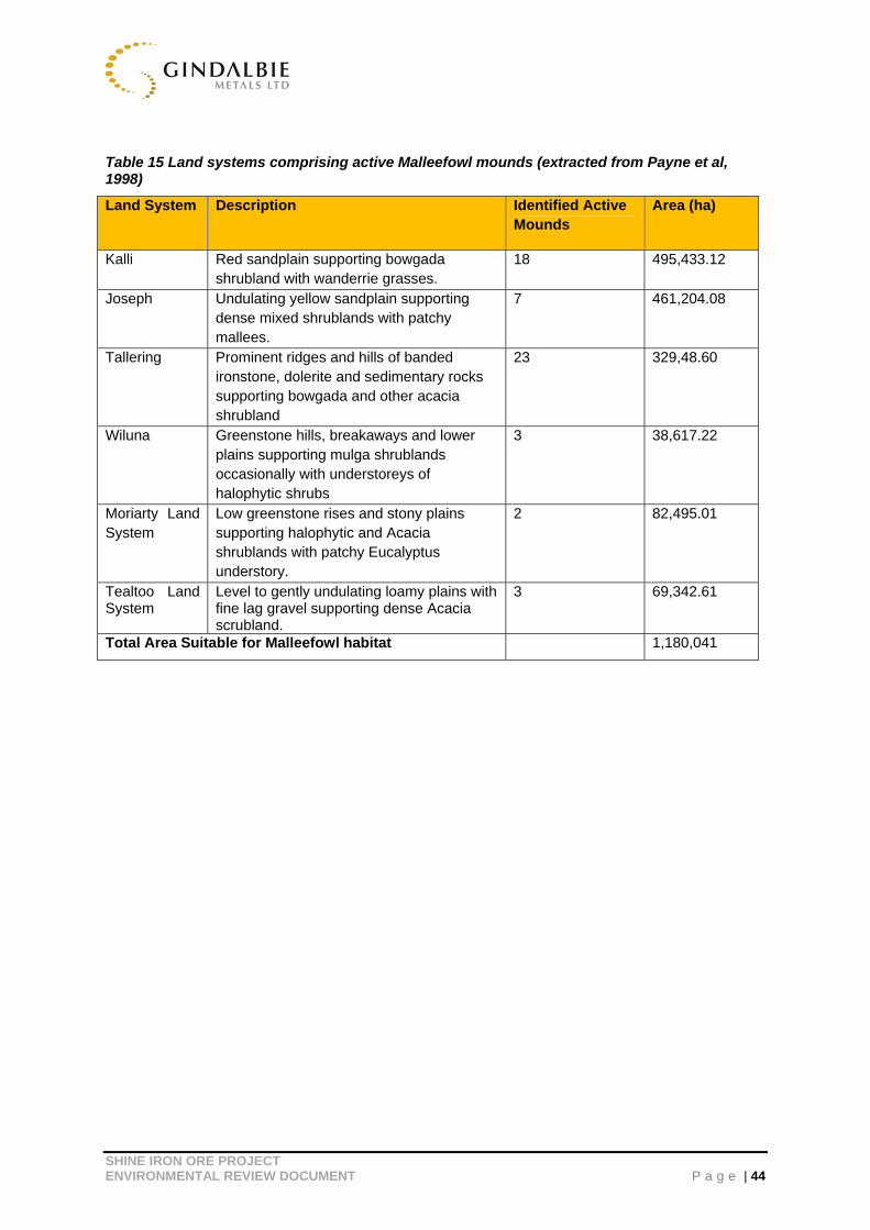
Habitat
Twenty-two (22) land systems, as detailed by Payne et al (1998) are identified over Badja station (owned by GBG) and the Regional Mapping Area. Six of these land systems comprise of active mounds and vegetation suitable for Malleefowl habitat which cover an area of 1,180,041ha (Table 15). Based on this area the impact of Shine and combined cumulative impact with GKIOP on Malleefowl habit is 0.02% and 0.13% respectively (Table 12).
SHINE IRON ORE PROJECT ENVIRONMENTAL REVIEW DOCUMENT P a g e | 44
Table 15 Land systems comprising active Malleefowl mounds (extracted from Payne et al, 1998)
Land System Description Identified Active Mounds
Area (ha)
Kalli Red sandplain supporting bowgada shrubland with wanderrie grasses.
18 495,433.12
Joseph Undulating yellow sandplain supporting dense mixed shrublands with patchy mallees.
7 461,204.08
Tallering Prominent ridges and hills of banded ironstone, dolerite and sedimentary rocks supporting bowgada and other acacia shrubland
23 329,48.60
Wiluna Greenstone hills, breakaways and lower plains supporting mulga shrublands occasionally with understoreys of halophytic shrubs
3 38,617.22
Moriarty Land System
Low greenstone rises and stony plains supporting halophytic and Acacia shrublands with patchy Eucalyptus understory.
2 82,495.01
Tealtoo Land System
Level to gently undulating loamy plains with fine lag gravel supporting dense Acacia scrubland.
3 69,342.61
Total Area Suitable for Malleefowl habitat 1,180,041
!! !
! !!!!!! ! !! ! !
!!!!
!!!
!
! !
!
!!!!!!
!
!!
!!!
!
!
!
!
!
!
!!! !!
!
!!
!
!!
!!
!
!!
!
!
!
!
!
!
!
!
!
!
!
!
!
!
!!!!
!!
!!!!!
!!
!!!!!
!
!
!
!!!!
!
!
!
!
!!
!
!
!
!!
!
!!
!
!
!
!
!
!
!
!!
!!!
!
!
!
!
!
!
!
!!
!
!
!
!!!!!!
!!! !
!
!
!!
!
!!
!!!
!
!!
!
!
!
!!!
! !!
!
!
!
!
!! !
! !!!
!
!!
!
!! !
!
!!
!
! !
!
!
!!
!
!
!!!
!
!!
!
!
!
!
!
!!
!!!
!
!!!
!!
!
!
!
!
!
!
!
!!
!
!
!
!
!!
!! !
!
!
!
!
!
!
!!!
!
!
!!
!
!!
!
!
!!
!!!
!
!
!
!
!
! ! !!
!!
!
!!
!!
!!!
!!
!!!
!!!
!
!
!!
!
!!
!
!!
!
!!!
!
!
!
!
!
!
! !!
!!!
!
!
!
!!
!
!
!
!!!
!
!
!
!!!!
!!!!
!
!!!!!
!
!!!
!
!!
!
! !
!
!!
! ! !
!!
!!!
!!!
!!
!!
!!!
!
!!
!! !!!
!!
!
!
!
!
! !
!
!
!!
!
!!
!
!
!
!
!
!
!!
! !
!
!
!
!
!
!!!
!
!
! !
!
!
!
!
!
!
!! !
!
!
!
!
!
!
!
!
!
!
!
!
!
!
!
!
!!
!!
!
!!
! !!!
!
!
!
!
460000
460000
480000
480000
500000
500000
6780
000
6780
000
6800
000
6800
000
6820
000
6820
000
6840
000
6840
000
Badja Station
Figure 8. Land Systems & Malleefowl Habitat23rd November 2012
0 5kilometers
MGA Zone 50 (GDA 94)
1:250,000
TS-ENV-Badja Land Systems & Malleefowl-JR-29Mar2012
Geraldton
Legend
! Inactive Malleefowl Mound
! Active Malleefowl Mound
Badja Pastoral Lease
FCTs Mapping Extent
Tealtoo Land System
Moriarty Land System
Joseph Land System
Wiluna Land System
Tallering Land System
Kalli Land System
SHINE
SHINE IRON ORE PROJECT ENVIRONMENTAL REVIEW DOCUMENT P a g e | 46
7 CONCLUSION
SIOP is considered a low scale iron ore mining activity with a ground disturbance of up to 200 ha, operating 12 hours a day (during day shift only) with a 2-5 year mining life. Over a period of 5 years, GBG has commissioned extensive specialist consultants to undertake detailed environmental studies within the proposal’s development envelope and identify the potential environmental impacts. Through this period extensive stakeholder consultations have also occurred to ensure concerns are appropriately addressed through a collaborative manner.
This document has addressed the OEPA’s key environmental factors of Vegetation and Flora, Fauna, Groundwater and Rehabilitation and Mine Closure at both a local, regional and cumulative perspective. It is evident that SIOP will not impact on any Threatened flora species, with only three Priority 3 Flora species identified within the disturbance footprint: Calytrix uncinata, Drummondita fulva and Micromyrtus trudgenii. There will also be no impact upon Threatened Ecological Communities and only a minor proportion (0.19%) of the Minjar/Gnows Nest PEC disturbed by developing the project
Impacts upon the fauna assemblage as a whole are expected to be insignificant. Impacts upon the key conservation significant species, being Malleefowl and Shield-backed Trapdoor Spider, are noted to be insignificant as their habitat is not restricted within the SIOP disturbance footprint. Where GBG are advised of the location of significant fauna and habitats within the development envelope, such as Malleefowl, these will be taken into account during project construction and operation activities with the objective of avoiding these areas. These will be identified as “Avoidance Sites” and will include a 30m buffer to ensure its avoidance and also further managed through and internal Approvals Request and Ground Disturbance management process.
SIOP has identified that there will be no water discharged to the environment through the mine life and regional water quality will not be impacted as a result of pit, drain or abstraction bore dewatering. The SIOP mine closure plan, implemented post mining, further addresses all closure related aspects associated with the direct mining of iron ore, operations including the mine site, mine pits, post-mine landforms and supporting infrastructures, through a strategic plan and implementation framework. It provides for the successful and environmentally sustainable closure of SIOP.
GBG considers SIOP to be unlikely to result in any significant impacts as all construction and operational iron ore mining activities will be effectively managed through sound environmental management measures such as avoidance, monitoring, implementation of appropriate management plans and procedures and post mine life rehabilitation measures.

SHINE IRON ORE PROJECT ENVIRONMENTAL REVIEW DOCUMENT P a g e | 47
8 REFERENCES Bamford Consulting Ecologists, 2012. Shine Project Area Fauna Assessment. A Report Prepared for Gindalbie Metals Limited. February 2012.
Bamford Consulting Ecologists, 2011. Review of Distribution and Abundance of the Shield-backed Trapdoor Spider in Karara Iron Ore Project Area: Surveys conducted from 2007 to August 2011. September 2011.
Biota, 2007b. Gindalbie Metals hematite project troglofauna survey. An unpublished report prepared for Enesar Consulting. Burswood. Western Australia
Botanica Consulting, 2012. Level 2 Flora and Vegetation Survey and Priority Search of the Shine Project,Tenements: M59/0730, M59/0406, M59/0421 & P59/1800, Prepared For Karara Mining Ltd. January 2012.
CRE, 2009. Draft Shine Iron Ore Project Surface Water and Drainage Assessment. March 2009.
DEC, 2007a. Recommended Interim Protocol for Flora Surveys of Banded Ironstone Formations (BIF) of the Yilgarn Craton, Department of Environment and Conservation.
DEC, 2007b. Banded Ironstone Formation Ranges of the Midwest and Goldfields, Department of Environment and Conservation.
DoIR, 2008. Banded Iron Formations. An electronic dataset published by the Department of Industry and Resources. Perth WA. January 2008.
Ecologia, 2008. Greater Karara Iron Ore Project subterranean fauna biological report. An unpublished report prepared for Coffey Natural Systems. Burswood. Western Australia.
Ecologia, 2009. Shine Subterranean Fauna Desktop and Pilot Study. February 2009. Environmental Protection Authority, 2007. Draft Guidance Statement No. 54a: Sampling methods and survey considerations for subterranean fauna in Western Australia. (Technical Appendix to Guidance Statement No. 54).
Karara Iron Ore Project Public Environmental Review. Volume 2. September 2008.
Malleefowl Presentation Group 2012 A Community Search for Malleefowl at Badja Station A Report for Karara Mining Ltd. June 2012.
Outback Ecological Services, 2009. Shine Project. Baseline Soil Survey. March 2009.
Pritchard Francis, 2012. Desktop Surface Water and Stormwater Management Study for the Shine Project. Shire of Yalgoo Western Australia. March 2012.
Rockwater, 2012. Shine Project. Results of Subterranean Fauna Pilot Study. Report for Gindalbie Metals Ltd. August 2012.
Rockwater, 2012. Shine Iron Ore Deposit. Assessment of Hydrogeology and Impacts of Mining. Report for Gindalbie Metals Ltd. March 2012.
SHINE IRON ORE PROJECT ENVIRONMENTAL REVIEW DOCUMENT P a g e | 48
Rockwater, 2012. Review of Subterranean Pilot Study and Recommendations for Further Work - Shine Iron Ore Deposit. February 2012.
Rockwater, 2009. Gindalbie Metals Ltd. Results of Permeability Testing Shine Iron Ore Deposit. June 2009.
Rockwater, 2008. Assessment of Groundwater Conditions and Availability, Shine Iron Ore Deposit. December 2008.
Shine Iron Ore Project Draft Environmental Management Plan, 2012. Gindalbie Metals Limited, March 2012.
Shine Iron Ore Project Proponent Information Document, 2012. Gindalbie Metals Limited, March 2012.
Soil Water Consultants. 2012. Shine Mine Closure Plan. Report prepared for Gindalbie Metals Limited. June 2012.
Soil Water Consultants. 2012. Shine Deposit Geochemical Characterisation. Report prepared for Gindalbie Metals Limited. February 2012.
Terra Rosa Cultural Resource Management, 2011. Heritage Survey of the Shine Development Area and Haul Road. October 2011.
Woodman Environmental Consulting, 2009. Exploration Drilling Programme – Shine Phase 3 – Flora and vegetation Impact Assessment. Report to Gindalbie Metals Ltd. February 2009.
Woodman Environmental Consulting, 2008b. Flora and Vegetation – Cumulative Impact Assessment, Karara-Mungada Project Survey Area, Karara Mining Proposal and Mungada Mining Proposal of the Greater Karara Iron Ore Project and Midwest Blue Hills DSO Project. Unpublished report to Gindalbie Metals Ltd. November 2008.
Woodman Environmental Consulting, 2007. Shine Prospect Flora and Vegetation Impact Assessment. October 2007.

Appendix A
Level 2 Flora & Vegetation Survey & Priority Flora search
of the Shine Project Area (2012)

APPENDIX B
Shine Project Area Fauna Assessment (2012)

APPENDIX C
Shine Project Results of Subterranean Fauna Pilot Study (2012)

Appendix D
Desktop Surface Water and Stormwater Management Study for the Shine Project. Shire of Yalgoo Western Australia (2012)

Appendix E
Shine Iron Ore Deposit.
Assessment of Hydrogeology and Impacts of Mining (2012)

Appendix F
Heritage Survey of the Shine Development Area and Haul Road (2011)

Appendix G
Shine deposit – Mine Closure Plan (2012)

Appendix H
Waste Rock Landform Design and Preliminary Closure Criteria study (2012)

Appendix I
Environmental Offsets Reporting Form