Embed Size (px)
DESCRIPTION
Geospatial Intelligence Forum, Volume 9 Issue 8, November/December 2011
Citation preview

Official Publication of the United States Geospatial Intelligence Foundation
November/December 2011 Volume 9, Issue 8
www.GIF-kmi.com
GEOINT Visionary
Letitia A. Long
DirectorNGA
Multisensor Data O Inland Navigation O Image DisseminationInformation Sharing O Intelligence Update O NGA Campus East

We Get the Point...
In Fact, We Get Billions. Together with Leica Geosystems, we offer the complete LiDAR workflow from capturing to delivering. Learn more about point clouds in ERDAS IMAGINE®, LPS, ERDAS APOLLO and Intergraph’s GeoMedia® at www.erdas.com/lidar

Geospatial intelliGence Forum november/December 2011 volume 9 • issue 8
Features cover / Q&a
21
Departments
2
4
6
18
34
35
Editor’s Perspective
Program Notes/People
USGIF
Industry Raster
Homeland Vector
Calendar, Directory
inDustry interview
Bill GrahamPresident and CEO
The SI Organization Inc.
36
Letitia A. LongDirector
National Geospatial-Intelligence Agency
Need-to-Share ArchitectureWhile inclusiveness should be a core principle, the challenge lies in balancing network security, business processes and mission requirements.By Samuel Unger and David Hsu
32
Fusion Comes of AgeWith their dramatically enhanced ability to detect, locate and track objects, advancements in technology for fusing data from multiple geospatial and other intelligence sensors are offering the military a host of advantages. By Karen E. Thuermer
10
Home for the FutureThe National Geospatial-Intelligence Agency has completed its transition to a consolidated new headquarters facility that brings employees together for better collaboration and equips them with the latest in technology and building design.By Harrison Donnelly29
Intel UpdateA report on the status of some key intelligence-related issues and pieces of legislation currently under consideration in the nation’s capital.By George Meyers
33
Rivers Run Through ItThe Army Geospatial Center’s inland electronic navigational charts were developed to improve maritime awareness on the 8,200 miles of rivers maintained by the U.S. Army Corps of Engineers.By Jamal B. Beck
27
Image Standard Speeds AccessIn the last year, JPIP image dissemination has been listed as a requirement in a number of Department of Defense and intelligence community image archive and dissemination programs.By Kate Heightley
30
www.GiF-kmi.com

As Geospatial Intelligence Forum gets ready to enter its 10th year of publication, we’re excited about the outlook for the maga-zine of the national intelligence community as it enters 2012.
After a highly successful 2011, we are planning to further improve our coverage of intelligence and geospatial technologies with a host of interesting new features, articles and interviews with key decision-makers. Our first Cover Story Question & Answer interview in the new year will be with Caryn Wagner, undersecretary of homeland security for intelligence and analysis, followed by the leaders of other key defense and intelligence agencies, who know us as an effective forum for communicating their perspectives to their communities and Congress.
In September, we’ll unveil the list of the “2012 Top Intelligence and Geospatial Companies,” followed by our big GEOINT 2012 Symposium issue in October. We’re also planning on a series of special reports on news-making organizations and issues.
There will be other changes as well, including in the relationship between KMI Media Group and the U.S. Geospatial Intelligence Foundation.
The partnership between GIF and the foundation, which began nearly three years ago, has been a productive one for both organizations. Each has grown and prospered during this time, and some of the joint efforts that have resulted have had a real impact on the field.
The time of transition has come for this particular relationship, however. We’ll continue to work together in other ways, as each organization pursues through different means their common goal of promoting and strengthening geospatial and other intelligence technologies.
As it enters its 10th year of publication, GIF is thriving, and more than ever dedicated to its mission of serving the military and intelligence communities and increasing awareness of the world-changing field of geospatial technology.
Official Publication of the United States Geospatial Intelligence Foundation
eDitorial
Managing EditorHarrison Donnelly [email protected] Editorial ManagerLaura Davis [email protected] A. Buxbaum • Cheryl Gerber • Karen E. Thuermer
usGiF eDitorial aDvisers
Keith Masback, President USGIFJordan Fuhr, Director of Communications USGIF
art & DesiGn
Art DirectorJennifer Owers [email protected] Graphic DesignerJittima Saiwongnuan [email protected] Designers Amanda Kirsch [email protected] Morris [email protected] Waring [email protected]
aDvertisinG
Associate PublisherScott Parker [email protected]
kmi meDia GroupPublisherKirk Brown [email protected] Chief Executive OfficerJack Kerrigan [email protected] Financial OfficerConstance Kerrigan [email protected] Vice PresidentDavid Leaf [email protected] Editor-In-ChiefJeff McKaughan [email protected] Castro [email protected] Show CoordinatorHolly Foster [email protected]
operations, circulation & proDuction
Manager, Circulation and OperationsToye McLean [email protected] CoordinatorDuane Ebanks [email protected] SpecialistsRebecca Hunter [email protected] Johnson [email protected] Jones [email protected] Villanueva [email protected] Walker [email protected] Winston [email protected]
subscription inFormationGeospatial Intelligence Forum
ISSN 2150-9468is published eight times a year by KMI Media Group.All Rights Reserved. Reproduction without permission is
strictly forbidden. © Copyright 2011.Geospatial Intelligence Forum is free to
qualified members of the U.S. military, employees of the U.S. government and non-U.S. foreign service
based in the U.S.All others: $65 per year.Foreign: $149 per year.
Corporate OfficesKMI Media Group
15800 Crabbs Branch Way, Suite 300Rockville, MD 20855-2604 USA
Telephone: (301) 670-5700Fax: (301) 670-5701
Web: www.GIF-kmi.com
GiF is the oFFicial publication oF usGiF
Geospatial intelliGence Forum
volume 9, issue 8 november/December 2011
kmi meDia Group maGazines anD websites
www.GIF-kmi.com
Geospatial Intelligence
Forum
www.MAE-kmi.com
Military AdvancedEducation
www.MIT-kmi.com
Military Information Technology
www.MLF-kmi.com
Military Logistics
Forum
www.MMT-kmi.com
Military Medical/CBRN
Technology
www.GCT-kmi.com www.MT2-kmi.com www.SOTECH-kmi.com www.TISR-kmi.com www.USCGF-kmi.com
Ground Combat
Technology
Military Training
Technology
Special Operations Technology
Tactical ISR Technology
U.S. Coast Guard Forum
Harrison DonnellyEditor

CLIENT BAE Systems GXP
DESCRIPTION GXP Xplorer 2011
PUBLICATION Geospatial Intelligence Forum
ISSUE April 2011
CONTACT Rachel Snyder, (858) 675-2850, [email protected]
ART DIRECTOR Laetitia Santore, (858) 592-5383, [email protected]
BLEED .125” / 8.625’” x 11.125”
TRIM Full page / 8.375” x 10.875”
SAFETY .125” / 8.125” x 10.625”
FORMAT PDF/X1a
COLOR CMYK
baesystemsgxp_gif_april11.indd 1 4/6/2011 11:51:21 AM

With four optical and radar satellites in orbit and four new optical imaging satellites to launch over the next three years, Astrium Services, through its extensive geo-information range of products and services, is gearing up to bring its customers the best that space technology has to offer, ensuring a continuity of service up to 2023 and beyond.
“We are bringing together a variety of capabilities to serve the entire GEOINT community, and it comes with several components,” said John Schumacher, vice presi-dent, space line of business for EADS North America and the head of Astrium activities in the U.S. “We are using our unique set of optical and radar imaging capabilities to provide a range of solutions to meet specific customer requirements. We are also focused on taking existing capabilities and improving and enhancing them over the next several years. With our current and future spectrum of capabilities, we can really meet a lot of different customer needs.
“What’s very exciting for us is that we are launching our first very high-resolution optical satel-lite, Pléiades 1, on December 16,” Schumacher said shortly before the scheduled launch.
Pléiades 1 is the first compo-nent of a two-satellite system oper-ated by Astrium Services. Pléiades will provide 50 cm optical prod-ucts in record time, offering daily revisits to any point on the globe and acquisition capabilities tailored to meet the full spectrum of civil and military requirements, including delivering data through
secure, unclassified and classified environments.
At 20 km, the Pléiades satellites have the widest imaging swath in their class. The satellite’s extreme agility, coupled with multiple acqui-sition modes, makes the system very responsive to specific user require-ments. In addition, automated production workflows ensure rapid delivery of orthorectified products. Astrium Services expects Pléiades 1 imagery and services to be commer-cially available early March 2012.
Customers are showing great confidence in the Pléiades program. The Pléiades 1 satellite has only just arrived in French Guiana, and three customers have already signed Pléiades Direct Access Services agreements with Astrium Services to operate direct receiving stations. After PASCO Corp. in Japan and Beijing Eastdawn Information Technology in China, both suppliers of geospatial solu-tions, the Canadian Department of Defence (DND) is the latest to place its trust in Astrium Services’ GEO-Information division, through a partnership with MacDonald Dettwiler and Associates. With this agreement, the DND is committing to Pléiades as well as to SPOT 5 and the future SPOT 6 and SPOT 7 satellites, thus giving it access to Astrium’s full optical Earth-imaging constellation.
The agreement with Canada’s Department of Defense is the most recent confirmation of our customers’ faith in the Pléiades constellation’s ability to meet a broad spectrum of customer requirements. More information is available at www.astrium-geo.com.
The Senate has confirmed I. Charles McCullough III to be the inspector general of the intelligence community.
NJVC has announced three senior management-level new hires: R. Jeffrey Bongianino, general manager, IT services; Michael Carr, general manager, programs; and Paul Polcsan, vice president, business development.
TASC has appointed Air Force Major General John T. Brennan (Ret.) to lead the compa-ny’s Air Force business unit. In addition, the company has named Bob Pattishall vice president of its systems engineering and inte-gration community of excellence. In addition, Marine Corps General James Cartwright (Ret.), former vice chairman of the Joint Chiefs of Staff, has joined the TASC board of advisors.
GeoEye has appointed Air Force General Michael P. C. Carns (Ret.) to serve on its board of directors. Carns has been appointed as the board representative of Cerberus Capital Management. GeoEye has partnered with Cerberus, which provided financing support of the company’s bid on the National Geospatial-Intelligence Agency’s EnhancedView program.
OpenGeo has named Eddie Pickle as chief operating officer, Tim Schaub as chief tech-nology officer, Ken Bossung as senior vice president, and Alyssa Wright as vice president of product and project management.
People
Compiled by KMI Media Group staff
PROGRAM NOTES
New and Existing Capabilities Serve the GEOINT Community
General James Cartwright (Ret.)
www.GIF-kmi.com4 | GIF 9 . 8

IAS. Situational Awareness in the Palm of Your Hand.
IASAll rights reserved. E3De, ENVI and IDL are trademarks of Exelis, Inc. All other marks are the property of their respective owners. ©2011, Exelis Visual Information Solutions, Inc.Image courtesy of DoD. Use of DoD image does not constitute or imply endorsement.
Real situational awareness requires real-time information. Geospatial imagery can provide the current information warfighters need to make critical decisions. In the past, an obstacle to using imagery in time-sensitive operations was the time it took to download multi-gigabyte images. Now, Exelis VIS provides solutions that enable warfighters to access the latest imagery information directly on their mobile devices, even over highly constrained bandwidths. Our products leverage the unique Image Access Solutions (IAS) streaming technology to deliver imagery quickly. From off-the-shelf applications to custom integration, we have the image delivery technology you need for the most accurate and current situational awareness. Find out more at www.exelisvis.com/IAS.
10-11_IAS_GIF_PrintAD_EXELIS.indd 1 10/28/2011 9:47:22 AM

USGIF from the Desk of the President
During this time of year, just after Thanksgiving, ramping up for the other holidays, we often reflect on the things for which we are thankful while we enjoy what is usually a slow(er) time around the office. We at USGIF certainly have a great deal to be thankful for.
We recently finished closing out our largest event of the year, the GEOINT Symposium. The symposium, which is the nation’s largest intelligence event, grew even larger again this year. We saw record atten-dance, with more than 4,450 total attendees from the defense, intelligence and homeland security commu-nities. These attendees also were able to explore our most expansive exhibit hall ever, which featured technologies and solutions from more than 250 exhibi-tors. It truly was an amazing turnout from across academia, industry and government. What made the overall growth in attendance even more gratifying was the increase in our government attendance, which climbed to almost 1,000.
Even with this wonderful increase, we understand it is simply impossible and unrealistic for every person who should be at the GEOINT Symposium to attend. So, USGIF, in the spirit of our status as a nonprofit educational foundation, has invested in an online video library so that everyone can watch—free of charge—all of the keynote speeches, panel discussions and breakout sessions on http://geointv.com.
This online archive also houses highlights from the daily GEOINTv news program as well as past and present speeches, panels and breakout sessions. GEOINTv has had more views in the last 60 days than in its history, and selections like the GEOINT 2011 opening video have been viewed and shared in significant numbers. I encourage you to take a look if you haven’t already.
In addition to record attendance and exhibits, other notable highlights from GEOINT 2011 included a sold-out Allder Golf Classic, which raised $25,000 for the USGIF Scholarship Program, and another successful Young Professionals Group (YPG)
GeoHunt service project. With the help of almost 50 USGIF YPG members, the GeoHunt educational expe-rience taught 50 local 5th- and 6th- grade students the basic principles of remote sensing and the geospatial information in an effort to excite them about a future in geospatial intelligence.
GEOINT 2011 was also the stage for the announcement of the annual USGIF Awards Program recipients as well as the latest presentation of the Arthur C. Lundahl Lifetime Achievement Award, which was given this year to Lieutenant General Paul E. Menoher (Ret.).
Another high point of the week was USGIF member Sotera’s initiative to raise money for the Fisher House Foundation. GEOINT 2011 attendees bought $3,700 worth of raffle tickets from Sotera for the chance to win an original, patriotic painting from renowned artist Stephen Fishwick. USGIF promoted the event and offered to more than match that amount in order to give Fisher House a total of $10,000. This will be allocated to the construction of a new Fisher House facility in San Antonio, Texas.
USGIF is truly thankful for the continued success of the GEOINT Symposium and other foundation events. We couldn’t have produced such a valuable GEOINT 2011 without the support of our USGIF members, exhibitors and sponsors. Naturally, I’d be remiss if I didn’t also note that we couldn’t accomplish all that we do without our steadfast, hard-working volunteers. Volunteers are the lifeblood of a nonprofit organization, and we appreciate all the great efforts of our volunteers.
The GEOINT Symposium is just one of the many programs USGIF produces annually. Next year we will again host the NGA Tech Showcase West as well as GEOINT Community Week, which includes AGIC, Tech Days, the USGIF Invitational and the NGA Tech Showcase East at NGA’s new headquar-ters in Springfield, Va. Our staff, committees and volunteers are also working on plans for Emerging Technology Workshops, GEOINTeraction Tuesday, GEOINT 101, additional accreditation programs, Young Professionals Group events and service proj-ects, a new series of thinker’s dinners, chairman’s events and much, much more.
In fact, as I write this month’s column I am in Amsterdam meeting with Geospatial Media and Communications to assist in the planning of the April 23-27 Geospatial World Forum. The international community also understands the unique power of GEOINT, and so we’ve teamed up with Geospatial
World Forum organizers to use their superb confer-ence to engage with a broader set of GEOINT users.
In addition to this new global opportunity, USGIF is partnered with the Open Geospatial Consortium to launch a new event called WhereCon. Taking place April 10-12, 2012, WhereCon is a three-day interactive discussion focused on location-based policy for both government and private sector entities. WhereCon will focus on national and international issues affecting the “power of place” with innovative keynote speakers, panel sessions and exhibitors. This is a critically impor-tant topic right now, for the future of the nation, and so we are hosting at the convention center in downtown Washington, D.C., to make it easily accessible for the decision- and policy-makers who need to be there.
I am very excited about our involvement in these two new events and ongoing potential for the USGIF Community to expand. I know the topics we will cover originate from our 200 sustaining member organizations, and I believe both events will be very successful based on the feedback we are getting from our members and our partners.
As we grow and change, so do our relationships with some of our partners. After several great years with KMI Media Group publishing Geospatial Intelligence Forum as the official publication of USGIF, we mutu-ally decided to part ways with regard to our formal relationship. Having GIF as our official publication has been successful collaboration. However, both of our organizations have grown, and while we both remain committed to supporting the GEOINT Community, our respective objectives have changed. We are proud of what we accomplished with GIF and the products we produced with KMI, and we look forward to continuing our relationship, albeit in another, less formal manner.
The arrival of a new year brings with it many exciting opportunities. I wish you a safe and happy holiday season, and we look forward to another successful and exciting year for USGIF, our members and our partners. I pledge that our commitment to supporting national and international security remains as strong as ever, and we will remain true to our mission to build the community, accelerate innovation, and advance the tradecraft.
Sincerely,
Keith MasbackPresident
Keith J. Masback, President, USGIF
www.GIF-kmi.com6 | GIF 9 . 8

Did you miss the GEOINT 2011 Symposium?If so, you missed …
Keynotes from community leaders…
Over 250 exhibitors displaying the latest defense, intelligence and homeland security technologies…
The nation’s largest annual gathering of intelligence professionals… Exclusive networking events…
Make sure to join us next year as the GEOINT Symposium returns to Orlando!
Where Our National Security Begins…www.usgif.org
CFC #88693Donate to USGIF Academic Programs
Watch all the presentations and highlights from GEOINT 2011 at

USGIF from the Desk of the PresidentUSGIFUPDATE
The USGIF Young Professionals Group (YPG) hosted its second young professionals program during the GEOINT Symposium, which took place October 16-19 in San Antonio, Texas. USGIF offered a significantly discounted registration price to all young profes-sionals, and the foundation selected and sponsored 15 young professionals who received complimentary registration and access to a special YPG program.
The following individuals received complimentary registration and partici-pated in an exclusive program at the Symposium: Michael Campanelli, RadiantBlue; Michael Coe, Booz Allen Hamilton; Heather Crotty, ObjectFX; John Fenwick, Skybox Imaging; James Freeman Sr., SAIC; Thomas Gertin, Northrop Grumman; Michael Grochol, USSOCOM; Robert Singer, DigitalGlobe; Jennifer Stansall, DigitalGlobe; Matthew Tenney, University of Arkansas; Lee Vorthman, NetApp; Nicholas Williams, BAE Systems; Kevin Worley, ObjectFX; and Eleanor Zimmerman, Wiser Co.
The YPG began the GEOINT 2011 program with the GeoHunt. About 40 YPG volunteers taught more than 50 students from local San Antonio elementary schools the basic concepts of mapping and geospatial intelligence during the interactive, educational exploration that was similar to a scavenger hunt.
Using an Android-based tablet and a digital map of downtown San Antonio, 10 teams of kids in the fifth and sixth grades paired up with Young Professional volunteers to find different pinpoints on the map that corresponded to well-known locations in the local area. Each pinpoint included a clue that kids worked together, with the help of the volunteers, to find the answers to and point them to their next destination. Through the GeoHunt service project in San Antonio, kids were
exposed to new technologies and basic mapping principles, and learned more about their city.
The 15 sponsored Young Professionals also participated in the exclusive, invite-only Chairman’s Reception. Here they were able to converse with top 100 leaders at the GEOINT Symposium. The highlight of the evening for many was when NGA Director Letitia A. Long and Director of National Intelligence James R. Clapper Jr. took time to speak to each of the individual 15 young professionals.
During special exhibit hall tours for these 15 young professionals, they were treated to an overview of the work of the National Reconnaissance Office work by NRO Director Bruce Carlson. Dr. Joseph Fontanella, Army geospatial information officer and director of the Army Geospatial Center, provided a briefing to them at the AGC booth. Finally, at the EMC Corp. booth, Army Major General John M. Custer (Ret.), the symposium master of ceremonies and a former commander of the Army Intelligence Center of Excellence, talked with the group. It was an amazing opportunity for these young professionals, and USGIF looks to expand the program for GEOINT 2012.
Following the symposium, the USGIF YPG continued its support of young professionals and giving back to the community by hosting a food drive for the Capital Area Food Bank and collecting toys for the Marine Toys for Tots Foundation in concert with the fall YPG networking events.
In the New Year, the YPG plans to continue to have monthly events on the third Wednesday of each month. To learn more about the YPG GEOINT program email [email protected].
Young Professionals Gain from 2011 YPG Program
www.GIF-kmi.com8 | GIF 9 . 8

Compiled by USGIF staff
USGIF from the Desk of the PresidentUSGIFUPDATE www.usgif.org
USGIF has announced Army Lieutenant General Paul E. Menoher (Ret.) as the recipient of the 2011 Arthur C. Lundahl Lifetime Achievement Award. The prestigious award was presented to Menoher in an on-stage ceremony during the foundation’s annual GEOINT Symposium.
Menoher was recognized for being a multi-INT visionary who championed integration of imagery and geospatial information. He held a series of demanding positions of great responsibility and spent 35 years on active duty as a highly decorated officer. Menoher was an early adopter of unmanned aerial vehicles, helping to make the Hunter UAV program a reality within the Army. He was a vocal supporter of using full motion imagery and part-nering with the National Reconnaissance Office to get information from national systems to tactical users.
One of Menoher’s biggest contributions to the geospatial community was his support in the creation of the National Imagery and Mapping Agency (NIMA), NGA’s predecessor. He assembled a team of Army experts to support NIMA’s task force and continually supported these efforts throughout each stage of the agency’s creation. He
also advocated for the Army to be the first branch of service to have a service GEOINT element within NGA and have a geospatial intelligence officer.
Menoher’s service included positions as commanding general of the Army Intelligence Agency, commanding general of the Army Intelligence Center and Fort Huachuca, Ariz., commanding general of the Army Intelligence and Security Command, and Army deputy chief of staff for intelligence.
The Arthur C. Lundahl Lifetime Achievement Award is presented, upon selection by the USGIF Board of Directors, to an influential member of the community who has demonstrated dedication to the geospatial intelligence tradecraft and whose actions serve as an example to others. Arthur C. “Art” Lundahl is recognized as the father of imagery analysis. He dedicated his life to the tradecraft, enabling him to gain the confidence of four U.S. presidents and significantly contribute to the GEOINT tradecraft and security of the United States. His immense contribution to the pioneering of the tradecraft is why the USGIF Lifetime Achievement Award was renamed the Arthur C. Lundahl Lifetime Achievement Award.
The Open Geospatial Consortium (OGC) and USGIF have teamed up to launch a new event in 2012. WhereCon 2012 takes place April 10-12 at the Walter E. Washington Convention Center in Washington, D.C.
WhereCon is the event for public- and private-sector decision-makers to gather and begin a dialogue on the synergies that location-enabled and place-based streams of information activity bring to every sphere of our lives. New location technologies are fundamentally changing the way busi-ness and government organize and make decisions. At the same time, such technologies and the spatially enabled data they produce are posing profound and vexing public policy challenges that society must tackle.
The explosive growth and interest in the geospatial dimension of our national security is increasingly shared by decision makers in civilian, govern-ment and industry. That is why the USGIF is partnering with the OGC to bring the promise and challenges of place-based decision-making to this larger national and global community.
Keynote speakers and panel discus-sions will cover topics including but not limited to location privacy, parcels and the mortgage crisis, observing and mitigating global risks, collaborating for healthy ecosystems, place-based policing, locating broadband and the digital divide, from smart grid to smart infrastructure, location in the cloud, empowering the mobile workforce with location services, and crowd sourcing geo-democracy.
Online registration is open at www.wherecon.com, and seating is limited.
USGIF and OGC Announce WhereCon 2012
Menoher Receives 2011 Arthur C. Lundahl Lifetime Achievement Award
www.GIF-kmi.com GIF 9 . 8 | 9

By Karen e. ThuermerGIF CorrespondenT
advanCemenTs In TeChnoloGy For FusInG daTa From mulTIple GeospaTIal and oTher InTellIGenCe sensors oFFer a hosT oF analyTICal and operaTIonal advanTaGes.
With their dramatically enhanced ability to detect, locate, and track objects, advancements in tech-
nology for fusing data from multiple geospatial and other intelligence sensors are offering the military
a host of new analytical and operational advantages.
The technology being developed is able not only to fuse information from different sensors of the
same modality and imagery sensors of different modalities, but also to fuse information from different
intelligence disciplines, develop new ways to reason and make decisions from fused information, and
provide fusion-based solutions to hard problems in a net-centric environment.
www.GIF-kmi.com10 | GIF 9 . 8

Sate
llite
imag
e co
urte
sy o
f Geo
Eye
GIF 9 . 8 | 11 www.GIF-kmi.com

Multi-source and multi-INT fusion is also examining mea-surements and databases for fused and composite signatures of targets of interest, conflation of multi-sensor and multi-modal-ity data, and development of automated fusion exploitation algo-rithms for handling particularly difficult situations.
Companies such as Northrop Grumman, BAE Systems, Harris, Merrick & Co. and ERDAS/Intergraph are developing certain uses for multi-source and multi-INT fusion that benefit the military and intelligence gathering.
Northrop Grumman, for example, is making significant investments in multi-modality sensing technologies for a sin-gle aircraft. These technologies would leverage multiple sensor types such as electro-optical (EO), light detection and ranging (LiDAR), hyperspectral/multi-spectral (HSI/MSI), and synthetic aperture radar (SAR) on a single platform working in concert to collect data.
“Additionally, we are working to move processing and dis-semination closer to the collection point instead of having to do all that work on the ground,” reported Sean Love, geospatial business develop-ment director at Northrop Grumman.
Such measures would cut costs and the time needed to bring timely and mission critical infor-mation to the user.
“Very simply, this would offer the military a better, more timely intelligence picture,” Love explained. “Multi-modality sensing provides a faster response with more detail as well as mis-sion specific collection. All this without needing to introduce another aircraft to get the data needed.”
Without multi-modality sensing, the only way to get all the different types of imagery data is to fly multiple aircraft, he explained.
For example, collecting EO and LiDAR infor-mation would be done with one aircraft where another aircraft would be dispatched to collect HSI/MSI data and still a third aircraft would be flown to collect SAR data.
“The new technology would enable all of these missions to be flown as a single mission,” he said.
sensor payloads
Merrick has been integrating multi-source airborne sen-sors for close to a decade. The typical sensor payload consists of a high resolution, true color EO digital camera and a special-ized LiDAR system containing a high grade position orienta-tion system (POS) consisting of an IMU and survey grade GPS system.
“Depending on client’s needs, we often integrate other air-borne sensors such as color infrared (CIR) cameras, video cam-eras, thermal cameras, and hyperspectral cameras,” outlined Matthew Bethel, manager of systems engineering at Merrick.
Among hyperspectral cameras, Merrill has past experience utilizing VNIR, SWIR, and LWIR sensors.
“With the use of the POS, all integrated sensor data can be fully orthorectified at the final deliverable stage through direct georeferencing processes combined with a very detailed LiDAR surface model,” Bethel explained. “This allows
Merrick to produce the highest accuracy of final products possible.”
Where most integration companies might stop here, Merrick adds extensive integration and total production workflow devel-opment and processing experience.
“We have working knowledge of all major airborne mapping systems and close professional relationships with their vendors,” Bethel remarked.
The company has developed its own multi-sensor flight plan-ning extension for Esri’s ArcGIS. This allows Merrick to plan for optimal acquisition and minimize reflights for any and all sensors.
“The products of this flight plan software are used during acquisition with the onboard flight management system,” Bethel explained.
Merrick has developed a very powerful data management sys-tem to organize, archive, transfer and process all multi-sourced
sensor data. “This foundation is vital when processing
multi-terabyte data missions flown day after day,” he added.
Merrick has detailed workflows for final pro-cessing of all sensor level data products. These workflows have been optimized with high per-formance computing techniques to produce end products as quickly as possible within a scalable processing environment.
At the core of its LiDAR processing is Merrick’s Advanced Remote Sensing (MARS) software.
“The primary purpose of MARS is to provide an end-to-end LiDAR processing software suite of tools,” Bethel explained.
The second strength of MARS is its powerful data fusion engine, which provides the user true multi-sensor data analysis and fusion between all raster/vector geospatial products and the actual LiDAR point clouds.
In Bethel’s opinion, what separates MARS from all other data fusion packages is its strength to operate on the actual full resolution LiDAR point cloud data, not derivative products of them, which are often rasterized and/or severely decimated.
“Within the MARS suite, there are many filter and analysis tools that are completely automated and batchable,” he said.
Examples of these include classifying and extracting build-ings under vegetation and helicopter landing zone analysis.
Using these powerful tools and extensive workflows, Merrick is unique from the aspect that all data fusion processes preserve, respect and track the accuracy of all input datasets through-out the entire process so that the end products have a true and measureable level of accuracy to reduce uncertainties, Bethel maintained.
“The same workflow and tools preserve temporal information throughout the data fusion process,” he said.
The system offers the military many benefits, such as simul-taneous acquisition with multiple sensor payloads.
“This lowers the cost of acquisition, keeps the tempo-ral state of all collected datasets consistent, and speeds up the processing throughput duration to end products,” Bethel reported.
Matt Bethel
Sean Love
www.GIF-kmi.com12 | GIF 9 . 8

lockheedmartin.com
© 2011 Lockheed Martin Corporation
In a world where events can unfold at dizzying speeds, decisions must be made quickly and decisively. Decision makers rely on the nation’s intelligence organizations to securely gather, distill, distribute, and share information that can come virtually from any place, any source, and in any form. At Lockheed Martin, we provide systems and solutions that make sense of it all. From analyzing geospatial-intelligence and UAV video feeds to defending networks against the most sophisticated cyber attacks. All backed by a team of highly skilled, experienced professionals who understand the intelligence mission and the technologies that drive it. Making sure government agencies have the critical decision advantage over our nation’s adversaries is all a question of how. And it is the how that Lockheed Martin delivers.
THIS IS HOW LOCKHEED MARTIN INTELLIGENCE SOLUTIONS
ON DEMAND™
WITH MEETINGMISSIONDEMANDS MISSION
314-62614_MissionDemands_GIF.indd 1 11/22/11 4:28 PM

Another advantage is the reduced uncertainty of locating and positioning targets through the process of propagating the differ-ent accuracies of each sensor used in the fusion engine.
“Finally, huge savings are found in the ability to minimize the amount of data that needs to be moved downstream by process-ing multi-source sensor data in an efficient manner and generate usable end products,” he added.
The technology solves a host of challenges, particularly the barriers to collecting as much information as possible to make confident decisions for target selection.
An example of this may be collecting HSI derived targets but not having adequate locational information for them, extracting a helicopter landing zone but not having three-dimensional power lines above detected by LiDAR, or being able to detect hot spot activity in a thick canopy environment but not having the LiDAR vegetation penetration capabilities to find the ground footpaths leading to the targets.
“These are only some of real world examples where proper multi-source sensor fusion collection systems, processing and final fusion derived data products can provide the most exploit-able information possible,” Bethel pointed out. “When utilized properly, this technology truly lives up to the goal of the sum being greater than the parts.”
vIsual and alGorIThmIC envIronmenTs
Products from Intergraph and ERDAS, which were recently united under common ownership, have a long history of enabling multi-source fusion. Both product lines support the use of a vast array of varying data formats and sensor types, and enable users to combine these sources in both visual and algorithmic environ-ments to derive information not attainable from any one source in isolation.
According to Tom Lobonc, executive product director, Intergraph Government Solutions, Intergraph’s GeoMedia pro-vides a unique ability to access geospatial data in almost any form to bring an integrated geospatial view together.
“Along with a broad set of powerful analytic and editing tools, GeoMedia enables customers in several industries to efficiently manage and understand their investments in geospatial assets,” Lobonc pointed out.
ERDAS provides a spatial modeling environment that allows users to create custom processing models that fuse various data sources to create derived information products.
“Both ERDAS and Intergraph’s GeoMedia suite provide a strong set of interfaces for data and metadata exchange that fully align with global spatial data infrastructure standards such as those specified by OGC and the INSPIRE Directive,” Lobonc explained.
Key features resulting from the integration of Intergraph and ERDAS products will be the addition of numerous vector processing capabilities, the ability for a user to create custom-ized processing operators, an expansion of the existing opera-tors to include many more ERDAS legacy functions, and the ability to use Python scripting to create sophisticated processing chains out of both supplied operators and third-party processing functions.
These processing chains can then be uploaded to the ERDAS Apollo server and made available via an OGC Web
Processing Service (WPS) to enable users connected via thin clients to execute a wide variety of geospatial processing remotely without requiring detailed knowledge of the algorithms themselves.
“The algorithms actually have built in intelligence that helps guide the user to data inputs specifically required for the algo-rithms while simultaneously excluding all unusable data from the available selections,” he said.
These processing models provide the military with multiple benefits. Among them are processing on demand on the server side (no local data required), no requirement for the user to have expertise in processing steps, a fully interoperable access and delivery mechanism using OGC services, and the ability to request and receive derived information products on mobile devices.
The processing models are also in high demand. “In fact, the ability for remote users to execute custom geospatial process-ing on demand over a thin client is in extremely high demand as we move from an environment consisting largely of existing stock products to an environment that demands highly flexible information products tailored to specific applications,” Lobonc stressed.
The models also solve a number of challenges, as exemplified in the following case study example:
• An operator is responsible for determining potential egress routes and helicopter landing zones to use at the conclusion of a mission.
• The information was prepared at the forward operating base with multiple data sources before the mission was initiated. At the conclusion of mission activities, the operator has determined that the planned egress routes and extraction sites are no longer usable.
• The operator uses his mobile device to contact the server and request WPS models that can generate a new mobility analysis and potential landing zones. The models are selected and they provide the operator with the best possible data sources for the analysis.
• The operator makes the final data source selection and initiates the processing. Within minutes a new mobility analysis and set of landing zones are sent back to the operator’s mobile device and they are immediately used to begin the egress and call in air support.
mulTIple InITIaTIves
Harris Corporation has many initiatives ongoing to address multiple aspects of multi source/sensor fusion. These projects range from one-stop shop multi-INT data access systems to multi intelligence data correlation in space-and-time with its Full Motion Video Asset Management Engine (FAME).
“We are also providing multi-source product genera-tion, including tactical imagery and LIDAR fusion,” com-mented Sleighton Meyer, spokesperson for Harris Government Communications Systems.
These initiatives provide multiple benefits to the military. For one, they provide access to multiple forms of intelligence via a single source and relate them in space and time.
www.GIF-kmi.com14 | GIF 9 . 8


“This enables the military to solve more complicated intelli-gence problems by having the bigger, more integrated picture,” Meyer said.
Relating multi-INT in space and time allows reconstruc-tion of events for forensics as well as activity modeling. It also enables missions that were previously impossible by combining the information from multiple sensors.
Normally, timely tactical imagery provides tremendous situ-ational awareness. Unfortunately, the inaccuracy of imagery pre-vents it from being used for other purposes. However, because Harris’ multi-sensor activities involve fusion of tactical imagery with LIDAR data, they enable targeting through very timely tac-tical imagery.
“Our multi-sensor solutions fuse the LiDAR and tactical imagery to provide tremendous accuracy, enabling users to select points from 3-D scenes that can be used in conducting precision missions,” Meyer added.
BAE Systems, meanwhile, has been collaborating with gov-ernment, industry and academia partners to advance, develop, and integrate multi-INT ISR processing, exploitation and dis-semination (PED).
“Using a standards-driven approach enables interoperabil-ity between PED systems, algorithms and multi-INT fusion,” remarked Jason Latonio, BAE engineer.
The goal is to provide answers to the end user, without nec-essarily focusing on what sensor, platform or data phenome-nology the intelligence data is derived from, Latonio explained. “These answers can then be used and fused with other informa-tion, and visualized and utilized in any mobile, Web or worksta-tion client that supports the standards landscape.
Capabilities are delivered into a virtual machine-based appli-cation infrastructure at multiple security levels as operational prototypes.
“Selected operational users can reach into the environment to access the prototype multi-INT systems and services for oper-ational testing and evaluation,” Latonio continued. “The warf-ighter, therefore, gains access to leading-edge technology early, helping refine usability and requirements before it is made avail-able to the larger intelligence community.”
Capabilities to date involve data management for IMINT, SIGINT, LiDAR, HSI, IR, SAR and ground moving target indi-cation. Search and discovery tools allow correlation across the data phenomenologies, where the data can then be pro-cessed by a suite of tools and services, such as data fusion algo-rithms, automated change detection, extraction algorithms, normalcy and anomaly production and a full spectrum of ana-lytical clients.
“The results are published to fused track, detection, extrac-tion and reporting repositories where the intelligence informa-tion is than discoverable and retrievable,” Latonio said.
It can also be used by referenced tools, thus enabling a con-tinuous intelligence production cycle, so intelligence informa-tion is improved and enriched continuously over time.
FuTure dIreCTIons
Without a doubt, multi-modality sensing technology is the future. From Northrop Grumman’s perspective, as budgets con-tinue to be stretched, the ability to fly one mission that would
accomplish what three or four missions today can accomplish will become more and more important.
“This technology also enables us to move toward a true multi-INT picture,” said Love. “The information gathered in a single multi-modality mission will be much more uniform than the way information is gathered today, since there is a time lapse between different types of data collection.
Latonio of BAE Systems sees future activities including the integration of WAMI, WAPS and FMV tools and services.
“These capabilities will benefit from existing applications already in place,” he said. “Capabilities are developed in rapid development cycles, with continuous user feedback, ensuring the highest quality product is delivered to users.
Additionally, using interface and data standards within the environment enables a great deal of re-use across capabilities and tools, eliminating stovepipes and proprietary implementations.
“Together with reduced cycle times to operations and reduced risk with user acceptance, this generates cost savings for our military, enabling GEOINT in the hands of users,” he concluded.
Multi source access and correlation in space and time enables activity modeling, Meyer noted. “This sets the stage for activity-based, predictive intelligence. This will allow analysts to focus more on the intent of our enemies.”
Bethel sees its biggest area of growth in more standardiza-tion of sensor product levels.
“This refers to file types, calibration processes and overall workflows,” he said. “This will promote more streamlined pro-cessing and improved consistency of varying sensors’ data, yield-ing better accuracies of derivative products.”
From this breakthrough will come more automation and faster processing aiming for near- or real-time data products, he maintained.
Lastly, in the future, the sensor fusion industry will be able to utilize modularized sensor payloads that have interchange-able components. The conversion form a LiDAR/SWIR/RGB col-lection to a LiDAR/LWIR collection will be effortless.
Meanwhile, the industry will continue on the trend of fusing more and more disparate data sources to provide complex anal-yses on demand.
“There will be a rapidly growing percentage of the overall information product requests that will be handled dynamically as needed rather than relying upon pre-generated products car-ried into the battlefield,” remarked Lobonc.
As the adoption of Open Geospatial Consortium and other standards increases, he added, users will receive the benefit of greatly increased interoperability among different software sys-tems--which will also provide a much greater variety of pos-sible information products that can be provisioned to a single receiving client. O
Contact Editor Harrison Donnelly at [email protected]. For more information related to this subject, search our archives at
www.GIF-kmi.com.
www.GIF-kmi.com16 | GIF 9 . 8

Weare
here.
Weare
here.Weare
here.
Engineering GEOINT so GEOINT finds you.
In these uncertain times, people rely on national security, defense and other federal agencies to protect our way of life. And those agencies have turned to TASC for 45 years to help them accomplish their most important missions.
TASC helps solve national security and public safety challenges by providing advanced engineering, systems architecture, decision support and geospatial services to the intelligence, defense and homeland security communities.
TASC. We are here.
Learn more at www.tasc.com.

The GeoMedia Motion Video Analyst Professional 06.01.02 from Intergraph enables defense and military analysts to geospatially inte-grate video with multiple intelligence sources for enhanced situational awareness and actionable intelligence. The full motion video analysis product empowers military, coalition forces and agencies to exploit and analyze full motion video from UAVs and other airborne vehicles for both tactical and strategic analysis, and combines with image analysis and surface analysis products to provide unprecedented situational awareness and decision-making confidence. Agencies can now integrate and geo-fuse full motion video with other data formats to generate a complete, multi-dimensional operational picture. The system embraces the analysis of all types of geospatial intelligence including raster maps, vector data, motion video, satellite imagery and signal intelligence. Additionally, users’ clipmarks and annotations are stored within the system for simple retrieval based on a query of location, time or any attribute of the video. In GeoMedia Motion Video Analyst Professional 06.01.02, users can now produce complete digital reports from live-stream full motion video within five minutes after identifying an item of interest in the video. This release also enables users to view full motion video in a single common geospatial environment, incorporating other types of geospatial information.
Stephanie Deemer;[email protected]
Exelis Visual Information Solutions has released E3De, a new, interactive software environment for visualizing and extracting 3-D features and products from light detection and ranging (LiDAR) data. E3De allows users to understand a geographic area of interest from all angles by creating realistic 3-D visu-alizations of man-made and natural features from point cloud data. The resulting products and visualizations add valuable informa-tion to a wide variety of geospatial applica-tions including assessing forest inventories, mapping urban growth, visualizing terrain and determining power line locations. E3De’s advanced software technology allows users to
ingest native LAS, NITF LAS and ASCII files, prepare the LiDAR data, fly through a realistic scene, identify and extract features, refine the resulting products, and, if desired, export the results for further analysis. In addition to the standard topographic products, E3De allows users to create advanced 3-D products from LiDAR data. These include trees, buildings, power lines and power poles. E3De products can be integrated to other geospatial applica-tions through a single-button export to ENVI or as shapefiles for inclusion in GIS mapping applications.
Kristen Maglia;[email protected]
Alliance Offers Increased Search Intelligence in Full Motion Video
ITT Exelis and Analytical Graphics Inc. (AGI) have joined to deliver increased search intelligence within ITT’s current suite of full motion video (FMV) and imagery processing and dissemination products. Leveraging AGI’s ISR mission modeling software, ITT’s adLib and Enhanced Agile Access solutions now have increased capabilities within their native search and discovery feature set for tactical users and operators. Together, these enhancements will provide end-users with added intelligence and relevant data-driven results to geospatial queries, while also significantly reducing the overall amount of data sent back for review and analysis. ITT’s adLib solution has revolutionized situational awareness
by enabling users to capture, manage and disseminate FMV and intelligence infor-mation in near real-time while optimizing system interoperability and bandwidth use. The company’s Enhanced Agile Access solution is a deployable, enterprise-ready imagery management and dissemination system. It supports contingency operations by dramatically reducing the time needed to deliver crucial geospatial intelligence anywhere in the world, thereby helping the warfighter find accurate geospatial data to make fast, effective decisions that impact mission success.
Irene Lockwood;[email protected] Welsh;[email protected]
GeoEye has received two new awards worth more than $25 million. These awards will increase the backlog for the company’s production services line of business. The first is a delivery order for “enhanced GEOINT delivery” for the National Geospatial-Intelligence Agency, which was authorized under the EnhancedView award that GeoEye received from the NGA in August 2010. Under this new delivery order, GeoEye will supply a significant amount of value-added commercial imagery over a large geographic area and distribute it through the company’s EnhancedView web hosting service. The EnhancedView web hosting service makes commercial imagery readily accessible to licensed federal customers across the National System for Geospatial-Intelligence. As part of this new enhanced GEOINT delivery award, the company will expand the EnhancedView web hosting service to support third-party data, crisis imagery and new government portals. The second award is a subcontract with Boeing for controlled image base production, under a Boeing contract that provides products to NGA. Under this subcontract, GeoEye will provide highly precise imagery products from multiple satellite imagery sources, including imagery from GeoEye’s high-resolution satellites.
Full Motion Video Product Enables Integration with
Multiple Sources
Software Extracts 3-D Features from LiDAR Data
Order Provides Commercial Imagery for
Web Hosting Service
www.GIF-kmi.com18 | GIF 9 . 8
Compiled by KMI Media Group staff

Pixia, a provider of big-data access solutions, and PV Labs, an image acquisition and analytics company, have announced their Commercially Operated Persistent Surveillance Solution, which provides a commercial turnkey solution to wide area motion imagery (WAMI) collection, processing and dissemination. A low-cost daily pricing model provides a rapid access, end-to-end commercial solution for public and private sector customers such as law enforcement, border patrol, federal emergency management officials and private companies. Pixia’s HiPER Stare product is a data access solution used to catalog, organize and share large volumes of WAMI data within a cloud-based architecture. Using PIXIA’s PaaS technology as a core foundation for high performance and scal-ability, consumers can access data at speeds beyond standard disk I/O. HiPER Stare provides SaaS apps and data consumers, access to WAMI data via Open Geospatial Consortium web services and a cloud file system. The PV Labs’ Tactical Content Management System acquires, processes, ortho-rectifies and maps PSI Vision WAMI data in real-time during acquisi-tion, and provides a data interface via a decoder API for real-time exploitation on airborne platforms. A flexible customer interface offers seamless integra-tion with existing processing, exploitation and dissemination infrastructure and when combined with PIXIA’s dissemination capabilities, creates a rapid and scalable space-time-searchable intel-ligence capability.
John Bastedo;[email protected] Ernst;[email protected]
TASC has developed a mobile application tool to drive interface design, increase application effectiveness, eliminate study time and improve produc-tion requirements. The app allows the customer to survey end-users in order to gather the right information needed to customize the interface based on different perspectives and mission needs. Understanding how the warfighter or disaster relief worker uses a mobile application is essential to ensure mission success. It’s important to take into account if the end-user is a foot soldier using a handheld device while wearing gloves, or a special ops fighter jumping from a helicopter at night; if the mobile app is being used on an iPad mounted to a Humvee dash-board, or by an analyst providing support using a desktop in an office. The TASC mobile application development team applies extensive large systems interfacing and cloud expertise to develop apps that support mobile deployment on iPhone,
iPad and Android devices, as well as back-end web technology architectures. TASC’s mobile satellite app allows those in the field to task multiple satellites at once, with any mobile device, turning intelligence into appropriate action. To ensure mission success, a customized interface that takes into account the needs of the specific user is essential. Whether it’s a soldier using a handheld device or a disaster relief worker holding an iPad, the application allows users to answer questions about the specific data needed and to see the interface on the exact device they will be using. In giving the end-user the ability to see the screen layout, choose the most effective button configuration, and consider unique ways to execute an operation, the needs of the end-user are addressed in the design phase.
Tony Dahbura;[email protected]
Tool Supports Customized User Interfaces for Mobile Apps
Turnkey Solution Offers Low-Cost
Access to Wide Area ImageryThe latest geospatial technology from Esri
will be embedded into Comm@nder, the Thales integrated C4I suite. Integrated in Thales’ commu-nications and information framework, Esri soft-ware will improve operational services for defense users and provide complete geospatial solutions for integrated C4I systems. The advanced battlespace display and analysis features will provide highly accurate, shared situational awareness and better decision support tools. With Esri technology, defense users who have little or no experience working with geospatial software will be able to exploit geospatial information from maps, imagery and sensors that commanders can then use for making decisions.
Comm@nder is the Thales family of integrated computerized C4I solutions. The suite’s standardized and open architecture hosts tactical communica-tions, network services and operational information systems for a broad range of network-centric defense and intelligence operations at the strategic, opera-tional and tactical levels. Defense users in NATO and several countries in Europe, Asia and the Middle East use Comm@nder for C4I applications. Esri provides geospatial capabilities to defense and intelligence organizations worldwide, including those behind the NATO Core Geographic Services project and the U.S. Department of Defense Commercial Joint Mapping Toolkit.
Geospatial Technology Embedded in Integrated C4I Suite
Northrop Grumman has successfully demon-strated a virtualized capability for software-only processing, called the Virtualized Common Imagery Processor (vCIP), for use as a cost-saving upgrade to the Common Imagery Processor (CIP). The vCIP demon-stration was held for members of the Department of Defense CIP Cross Service Integrated Product Team. The CIP is the standard image processor for use in DoD. Northrop Grumman designed and built the CIP, which successfully replaced numerous stovepiped processing systems for tactical imagery platforms throughout the U.S. military. Northrop Grumman has continued to evolve the CIP to keep pace not only with new sensors, but also with new processing capabilities. The company’s CIP team repackaged its proven CIP software into a virtual machine environment and generated templates for all current sensor types that
CIP handles. The demonstration consisted of running two separate missions simultaneously on standard COTS hardware. VCIP sent imagery products to an Imagery Product Library and registered associated metadata. VCIP also sent wireframes and tracks to several workstations, and output the information on a Google Earth display. The vCIP provides the capa-bility of using DoDIIS- and JITC-certified solutions to provide the intelligence community with the latest in software-only processing applications for a variety of ISR sensors. The vCIP also provides additional services and features like imagery chipping, output product formatting, improved geolocation accuracies and artifact correction. The vCIP is configurable based on individual user and mission requirements.
Alleace Gibbs;[email protected]
Virtualized Imagery Processor Offers Cost-Saving Upgrade
www.GIF-kmi.com GIF 9 . 8 | 19

© 2
01
1 G
eoEy
e. A
ll R
igh
ts R
eser
ved
. Commercial geospatial imagery is an integral part of the modern warfi ghter’s arsenal. GeoEye® provides rapid access to critical intelligence that enables our warfi ghters to see, understand and respond to change. And it’s 100% unclassifi ed, so it’s easily shared with coalition partners. Our public-private partnership with the National Geospatial-Intelligence Agency (NGA) means we provide this capability at a great value for taxpayers.
GeoEye. Protecting our men and women in combat. Protecting taxpayer dollars.
Visit www.geoeye.com/NationalSecurity to learn more about GeoEye.
GeoEye- 1 — 03 . 1 3 . 1 1 Unclas s ifie dKabul , Afghan i stan
Put eyes on the groundbefore boots hit the ground.
Client: GeoEyeAd Title: Eyes on the GroundPublication: Geospatial Intelligence ForumTrim: 8.375” x 10.875” • Bleed: 8.875” x 11.375”
27634 Eyes on Ground_GeosIntForum.indd 1 12/1/11 3:57 PM

Letitia A. Long was appointed director of the National Geospatial-Intelligence Agency on August 9, 2010.
Prior to her appointment, Long served as deputy director of the Defense Intelligence Agency (DIA) from May 2006 until July 2010. Previously, she was the deputy under secretary of defense for intelligence (policy, requirements, and resources) from June 2003 until May 2006. She also served as the dep-uty director of naval intelligence from July 2000 to June 2003 and as the director of central intelligence’s executive director for intelligence community affairs from January 1998 to June 2000, where she was responsible for communitywide policy for-mulation, resource planning, and program assessment and evaluation.
Long entered civilian federal service with the Navy in 1978 as a project engineer in training with the David Taylor Research Center. Upon completion of her degree in 1982, she contin-ued with the David Taylor Research Center for six years, work-ing on various submarine acoustic sensor programs. In 1988, she joined the Office of the Director of Naval Intelligence, where she managed intelligence research and development programs.
Long was selected into the Senior Intelligence Executive Service in July 1994 and was dual-hatted as the director, Requirements, Plans, Policy, and Programs Office for the Navy intelligence staff, as well as the director of resource manage-ment for the Office of Naval Intelligence (ONI). From 1994 to 1996, she was on rotational assignment from ONI to the DIA as the director of military intelligence staff. In 1996, Long joined DIA as the deputy director for information systems and services, where she directed DIA’s worldwide information technology and communications programs. She was also DIA’s first chief infor-mation officer.
Long earned a Bachelor of Science in electrical engineering from Virginia Tech and a Master of Science in mechanical engi-neering from the Catholic University of America.
Long was interviewed by GIF Editor Harrison Donnelly.
Q: In your recent remarks to the GEOINT 2011 Symposium, you addressed what had happened in the year since you out-lined your vision of “Putting the Power of GEOINT in your hands.” How would you sum up your conclusions on what you have seen so far?
A: I am optimistic about the progress I’ve seen in implementing the NGA vision, and I want to see more. I’ve talked with so many
of our GEOINT users, and they are ready for the changes we are delivering. There are a lot of good ideas out there that will create new value for our GEOINT users. The men and women of NGA and our partners from across the intelligence, defense, indus-try and academic communities are aggressively implementing the NGA vision.
In the first year, we laid the foundation necessary to make this vision a reality and generated important conversations throughout the agency and among our partners to align efforts, identify redundancies and build a roadmap for the way for-ward. We delivered several mobile applications, or apps, serving a variety of domestic and military mission sets. We also chal-lenged the way we did business by establishing incubators and test beds—learning cells—based around real, operational intel-ligence mission sets. We purposefully applied new sources, ana-lytic methodologies and new business practices to see what was possible and where we had gaps. All of this work culminated in the identification of a set of strategic initiatives. Each initiative is a set of integrated, objective-oriented, measured and time-bound activities that are delivering key capabilities.
Taken together, the strategic initiatives will ensure our con-tent is discoverable and accessible through an open IT environ-ment, allowing GEOINT users—inside and outside of NGA—to operate in a self-, assisted- and full-service environment and
Letitia A. LongDirector
National Geospatial-Intelligence Agency
www.GIF-kmi.com GIF 9 . 8 | 21
GEOINT VisionaryStrengthening Analysis and Making Content More Accessible
Q&AQ&A

enabling analysts to do deeper and richer analysis. This is about continuous improvement, and the work accomplished so far has whetted the appetite of the GEOINT users—whether they are customers, creators, contributors or collaborators.
Q: Your address devoted a considerable amount of time to demonstrating some of the new mobile apps being developed by NGA. How would you characterize progress in that area?
A: This is an area that has a great deal of growth potential. We’ve had great initial success with our application in support of the homeland security/domestic disaster support mission, sometimes building them on the fly in response to our analysts observing operations in the field. In addition, in support of our safety of navigation mission, we are delivering a mobile device-enabled set of air navigation aids, helping to streamline our pro-cesses, get updated information to the user faster and reduce paper product generation.
We have worked with our community partners to develop applications for the warfighter to access commercial imagery and with our industry partners to help integrate geo-positioning capabilities. This area is clearly made possible by geospatially enabled content that is discoverable and accessible, a support-ive open IT environment, and a customer service model that allows users to interact with content in a way that best suits their needs. We still have a lot of work ahead of us—work that is necessary to enable this new way of doing business and facili-tate NGA’s transformation.
Q: Your 2010 vision also included a call for deepening analytic expertise. What do you see as the key accomplishments and challenges in that area?
A: Building and deepening analytic expertise is a top priority. A key component of building analytic expertise is understand-ing issues broadly and applying tradecraft to anticipate what the consumer will need. Over the past year, we have focused our analytic efforts and discussion around the intelligence ques-tions of utmost concern to national security decision-makers. Beginning with new analysts, we have focused them on going beyond the GEOINT tradecraft and encouraging them to delve into a broader grasp of what’s happening in their area of respon-sibility—the leadership, demographics, population and so on. Armed with this broader knowledge, analysts can provide bet-ter context to their GEOINT analysis, participate more actively in community discussions, and help consumers understand the significance and implications of a course of events. Building expertise is a process, but all of these steps help contribute to an analyst’s grasp of an issue and our ability to answer the hard questions. But building expertise takes time—time on an account, time researching, reading and writing, time in training and academic work, and time discussing with colleagues. A key goal of the vision is to provide an analytic environment where analysts spend their time doing analysis and not waste their time looking for data, or building spreadsheets, or signing onto multiple systems. The realization of the vision will give ana-lysts the time to do analysis, build their expertise and deepen our analytic understanding against some of the most challeng-ing issues we face.
Q: What is your process for measuring achievements by your agency?
A: We recently approved a suite of metrics that we will use to determine our progress toward achieving our vision. Our met-rics were selected to measure the extent to which we are achiev-ing our objectives. These metrics measure progress in making content accessible and discoverable across the GEOINT com-munity; creating an open IT environment where GEOINT appli-cations can be shared and used; developing customer service processes to enable self-, assisted- and full-service capabilities; and strengthening analytic capabilities and processes to fully address key intelligence issues.
Our leadership will review the metrics on a quarterly basis to keep the agency on course for achieving our vision. Many of our measures focus on online capabilities using the model of spreading business via the web. These quantitative measures will identify whether our customers can easily access and use our GEOINT data, products and services to meet mission needs. They will also help us determine whether our online users are consuming, creating, collaborating or contributing during their online sessions. Other measures monitor our progress toward developing online self-service apps that our customers will use to consume our GEOINT data or create their own GEOINT products.
We also have metrics that focus on the value of our GEOINT analysis. We will determine if NGA is performing and publishing anticipatory analysis that focus on key intelligence questions. The expectation is that NGA’s intelligence will prepare our cus-tomers to anticipate potential national security issues and rap-idly respond to them if they arise.
A very important aspect of our metrics program is customer satisfaction measures. We are building simple, online reviews to solicit customer feedback regarding the quality, relevance and timeliness of our online GEOINT products and services. In addi-tion, we are conducting face-to-face interviews with our cus-tomers to determine whether the information technology and GEOINT content meets their needs and improves over time. These qualitative measures will provide valuable customer per-spectives to enhance the assessments from the quantitative metrics.
Q: The theme of the recent symposium was “forging integrated intelligence.” What is NGA’s strategy for contributing to this widely acknowledged goal?
A: NGA is closely aligned with the director of national intel-ligence’s [DNI] strategy on integration, working closely with the national intelligence managers. Our strategy to support integration is based on collaborating with our counterparts, understanding the context and issues of our key consumers, and aligning GEOINT analysis accordingly. GEOINT, by its very nature, provides the critical underpinning to integrate all of the other INTs on many issues and naturally postures NGA to take a key role in forging integrated intelligence. Our goal is to ensure GEOINT plays an effective and key role in intelli-gence issues and support. Our proactive approach to reach out to our consumers or embed ourselves with them allows us to “show” them how the power of integration can be effectively
www.GIF-kmi.com22 | GIF 9 . 8

S T R A T E G Y & O R G A N I Z A T I O N | T E C H N O L O G Y | E N G I N E E R I N G & O P E R A T I O N S | A N A L Y T I C S
Ready for what’s next. Ready for what’s next. Ready for what’s next. Today’s dynamic and interdependent intelligence missions require
unprecedented, real-time access to content, tools, and expertise. The ability to leverage vast amounts of
existing information and rapidly evolving off-the-shelf applications and tools requires a new way of problem
solving. Booz Allen Hamilton, a leading management and technology consulting fi rm, combines agility with
a technology-independent approach to partner with our clients to achieve mission success. From systems
engineering and acquisition to objective analysis and program management, Booz Allen brings together the “art”
of management and the “science” of engineering to provide more agile and adaptive holistic solutions. Whether
you’re managing today’s issues or looking beyond the horizon, count on us to help you be ready for what’s next.
Ready for what’s next. www.boozallen.com/engineer-operations
BA11-462_Geospatial Intel Forum Ad_120211Final.indd 1 12/2/11 12:43 PM

enabled with GEOINT. This approach has and will continue to pay off major dividends.
Q: What do you see as NGA’s greatest challenges?
A: Among the agency’s biggest challenges is the constant strug-gle to achieve a proper balance between the demands to support our range of mission partners in the “current fight,” while at the same time planning in a very deliberate manner to effectively meet tomorrow’s strategic and operational requirements. As a combat support agency our highest priority is warfighter sup-port, but at the same time the agency cannot neglect the longer term need to prevent strategic surprise and to understand devel-oping threats over the horizon.
NGA support to the warfighter in Iraq and Afghanistan includes both embedded and reach-back support—leveraging the analytic firepower of the NGA analytic corps at our NGA Support Teams and in NGA facilities. We have also been devel-oping a cadre of analysts that can repeatedly deploy to corre-sponding geographic and functional areas, thus increasing the efficiency and effectiveness of support to operational forces, demonstrating that NGA is capable of adapting to the needs of our partners and providing insightful analysis and products that support a variety of intelligence needs.
Another challenge is the sheer amount of data in both types and amount from an ever-increasing list of sources, and the requirements to ingest, process, exploit and analyze it all in a way that becomes more meaningful to a decision-maker. The concurrent challenge is content management in deciding how much data to keep, where and for how long to store it, and how to do so in a manner that is discoverable and accessible. NGA is also working with the challenges of deepening our analysis, exploring new phenomenology and tradecraft to close key intel-ligence gaps, and dealing with the challenge of emerging threat detection through an increased focus on transnational and non-military challenges, while tracking activity-based trends.
NGA’s traditional order-entry processes and supply chain model are outdated, and we are working to adapt our role from a legacy producer of product to a broader role as a GEOINT service and application provider that enables end-users to configure GEOINT according to the needs of specific users, particularly in the expanding mission areas of homeland security and disas-ter relief.
We are also working closely with our counterparts to address challenges in cyber-operations for the entire Department of Defense and intelligence communities and NGA’s growing role supporting lead agencies with geospatial intelligence to identify and locate cyber-threats. At the same time, we are taking the responsibility seriously to protect our own infrastructure from cyber-threats, and constantly working to that end.
As the GEOINT mission evolves, we also need to ensure NGA aligns its operating model with NGA’s vision, balance our resources in light of fiscal realities, and invest in initiatives that will provide lasting value for the entire GEOINT analytic enter-prise. In light of the DNI and secretary of defense’s direction for agencies to assess where workforce efficiencies can be achieved, we have conducted extensive reviews of our current mission construct, doing away with unnecessary redundancies and obsolete technology and considering how we will position NGA
to most effectively and efficiently close the gaps on key intelli-gence questions. We are also ensuring we uphold those interests most vital to our mission partners and pursue opportunities to leverage the full analytic capabilities of the National System for Geospatial Intelligence [NSG] and Allied System for Geospatial Intelligence [ASG].
Q: What topics have you been focusing on in your role as the functional manager the NSG?
A: My primary responsibility is the development, coordination and promulgation of standards across the NSG that apply to GEOINT systems, collectors, training and tradecraft. Effective management of standards serves to bind our community together, keep us in pace with industry common practices, and ensure interoperability of our technological solutions. My sec-ondary responsibility for the NSG is ensuring that the GEOINT community aligns its resources and priorities. Inevitably, when budgets are ample, funds may not match up cleanly with prior-ities. However, in the declining budget environment, we must collaboratively re-evaluate our country’s greatest needs, decide who can provide them, and determine how we will pay for what is required.
To accomplish this, I initiated an NSG assessments program, which for the first time will develop a communitywide GEOINT baseline that illustrates our community’s capabilities and iden-tifies programs that can be leveraged to avoid duplication. This undertaking will require time to complete, but the payoff will be worth it. The NSG has evolved over the past few years, and it is now mature enough to take on new challenges from a commu-nity perspective. This effort can only be successful with a uni-fied community and a willingness to address these challenges jointly.
Q: NGA is one of five intelligence agencies working to restructure and consolidate IT programs, which DNI James Clapper suggested would need to bear a major share of anticipated budget reductions. What role do you see NGA playing in this, and what impact do you see on it?
A: There were actually four agencies initially working on this effort: NSA, NRO, DIA and NGA. Subsequently, the CIA became the fifth agency involved. To help put things into perspective, let me share a bit of the genesis for this effort. In November 2009, the directors of NSA, NRO, DIA and NGA signed a mem-orandum of understanding forming a collaborative partnership tasked to eliminate traditional information-sharing barriers and to improve cross-agency intelligence support among the four DoD agencies. This partnership came to be known as the Quad.
Information technology engineering and technical working groups representing the four agencies met over the last year and a half, leading to the concept, design and development of a com-mon operating environment [COE] across the Quad. The work-ing groups are divided into six integrated process teams [IPTs] with each team led by an agency representative. NGA is the lead for infrastructure services, which includes the base oper-ating system and related services that enable the environment such as a consolidated user directory and virtualization ser-vices for a common desktop. Other teams include Undercarriage
www.GIF-kmi.com24 | GIF 9 . 8

[for example, facility and hardware], Security, End User Service [email and other applications], Customer Care, and Operations and Maintenance. Each of the agencies, now including the CIA, contributes subject matter experts to work with the lead agency to deliver the team’s objectives. The structure of the IPTs enables each agency to work together delivering the COE while ensuring their unique intelligence services are available to the entire IC.
During 2010 and early 2011, there were two other strategic initiatives taking place that are now looking toward the COE as a shared or partial solution for their initiatives. First is the NGA vision of putting the power of GEOINT in the hands of the user, and second is the DNI’s IC IT Efficiency Study. The com-bined outcomes of these efforts support not only NGA’s goal to “broaden and deepen analysis,” but also the IC’s goal to “reduce IT across the IC and enhance information sharing and discov-ery.” In fact, the IC efficiency study group looked toward the Quad COE [now the Quint] initiative as a model for gaining IT efficiencies across the IC.
In support of Director Clapper’s vision, NGA has dedicated a senior executive to lead execution of the IC COE strategy. This strategy includes implementing network standardization; creat-ing a new common domain; replicating common user services [email, security, suite of common applications, voice, video and chat]; and enabling an IC virtual desktop from any participat-ing desktop, anywhere. We fully anticipate that the IC COE will become a solid foundation for the NGA vision of putting the power of GEOINT in the hands of the user, create new value by broadening and deepening analysis, and become the basis of IT efficiencies and budget savings for NGA and the entire IC.
Q: What are NGA’s goals and strategies in the field of “human geography” or “socio-cultural analysis”?
A: Human geography [HG] is an analytic approach used in describing spatial and temporal patterns of human behavior in the context of their environment. Incorporating HG into GEOINT analysis enables an analyst to fully consider the human element that is critical to understanding why people do what they do, where they do it, and how that influences the environ-ment. HG is widely recognized in academia as the study of the world with people at the nexus. In the GEOINT context, we are talking about data and information derived typically from non-traditional sources that extend beyond the physical features of the earth, for example hydrography, geodetic control and coor-dinate system and terrain, or the human infrastructure, such as roads, buildings and power.
Deepening and broadening our analysis means integrating a wide range of political, economic, socio-demographic data and information that can be mapped to people and by exten-sion to those associated locations and points in time. Humans are always connected to places on the earth at any point in time. Some human geography information is already incor-porated in NGA data stores, such as place names and political boundaries. However, NGA recognizes that in one form or another, much more data and information exists and needs to be exploited. We are actively pursuing opportunities to partner across the NSG and ASG, to include industry and academia, in an effort to discover ongoing activities, identify and integrate
new tradecraft, discover and address shared challenges, and seek cross-functional solutions.
Q: What do you see as the agency’s most significant steps in the past year in using commercial imagery, and where do you see that going in the future?
A: The Departments of Defense, State, and Homeland Security are among the many U.S. customers who rely on commercial imagery to support operations worldwide. In 2011, NGA used commercial imagery to quickly develop geospatial products to support operational planning and situational awareness for U.S. and coalition forces during the Libya crisis. Commercial imagery via the web-based Rapid Delivery of On-line Geospatial Intelligence is used routinely by U.S. and coalition forces in Iraq and Afghanistan to support mission planning, situational awareness and nation building. Commercial imagery provided current, shareable GEOINT in support of search, rescue and recovery during disasters such as the Midwest flooding and tor-nados, and for international humanitarian/disaster relief efforts, such as those following the Japanese earthquake and tsunami.
NGA’s commercial imagery program continues to respond to growing user demand by enabling easier online access, better quality imagery, enhanced spectral diversity, improved revisit timelines, and more complete foundational global coverage to support future contingency operations. NGA is also
VISION IMPLEMENTATION
At L-3 STRATIS, we help organizations make the technological and cultural changes needed to implement their vision. Our innovative cyber, intel and IT solutions enable your mission, while reducing costs and improving the user experience.
STRATIS L-3com.com
To find out more, contact [email protected]
www.GIF-kmi.com GIF 9 . 8 | 25

revolutionizing satisfaction of critical GEOINT requirements through a program that automatically orthorectifies single images into “map ready” GEOINT within 24 hours of satellite downlink, and then makes them available online, on-demand directly from the vendors. These new products provide the U.S. government and our coalition partners a high quality current image foundation built to Open Geospatial Consortium stan-dards and available via web services.
NGA’s commercial imagery program is a key enabler of put-ting the power of GEOINT into the hands of the nation’s warf-ighters, coalition partners, first responders and IC. Commercial imagery is unclassified, shareable and enables self-service GEOINT analysis. It is the foundation upon which multiple lay-ers of information are overlaid for predictive analysis, mission planning and a host of other governance activities.
Q: What impact do you think the new headquarters will have on the work of the agency in the future?
A: The recently completed deployment to our new NGA head-quarters allowed us to unify our workforce in the east for the first time and create the conditions for NGA to achieve and har-ness significant, unrealized potential in a number of ways. NGA was intimately involved in all facets of the design from the ear-liest stages, meaning that the campus is purpose built to enable the workforce to deliver better geospatial intelligence.
Geographically, the consolidation from six separate sites scattered around the Washington, D.C., metro area to one loca-tion provides a mechanical advantage in our collaboration and communication both within the agency and among our mission counterparts within and outside the DoD and IC.
Technologically, the consolidation helped the agency to fun-damentally transform our IT environment. We pushed adop-tion of virtualization—utilizing a mix of server, application, network, storage and desktop virtualization technologies—to reduce costs and improve performance. These technologies allow us to be much more agile in how we build and deploy new IT capabilities to our users around the world. We’ve also improved our ability to collaborate both within and outside the agency, by giving every employee access to secure and non-secure phones and by integrating our video teleconferencing system with our partners on JWICS.
Operationally, the new facility includes a state-of-the-art, central NGA Operations Center where we are able to maintain a common operating picture of worldwide geospatial intelli-gence priorities, and communicate and orient to support our mission partners about what’s relevant in order to better help our clients.
Socially, the campus was designed to promote an envi-ronment of collaboration among the workforce, with a cen-ter of activity in the form of an atrium surrounded by meeting and gathering places that encourage collaboration and com-munication, a radical departure from “traditional, cave-like” workspaces seen in many federal buildings. As mentioned pre-viously, the campus achieves people benefits through the con-solidation of a good portion of the analytical workforce in one place, enabling more interface that helps with productivity. Workspaces and work stations are open and airy to encourage our workforce—particularly analysts—to collaborate with their
peers on a continuous basis. Obviously too, for the large portion of the workforce at NGA Campus East [NCE] the advantage of being able to get up from your work station and visit a counter-part in any part of the building also improves our mission effec-tiveness and efficiency in ways we are just beginning to realize. Similarly too, the strength we gain through the NCE consolida-tion also certainly benefits the large St. Louis-based NGA work-force and other personnel worldwide locations in their dealings with NCE.
Q: Geospatial intelligence clearly played a key role in many of the military, intelligence and humanitarian operations of the past year. What lessons have you learned as a result?
A: That the power of GEOINT that NGA brings to decision-mak-ers can help save lives and better accomplish a mission, whether it is under our Title 10 or Title 50 authorities, and that we can always get better. Putting the power of GEOINT in the hands of the user is something we need to improve, and we’re on the right track. It is not just about improving—making more effi-cient and effective—the mission partners’ use of GEOINT. It is also about NGA providing that deeper/broader analysis that enables better decision making at all levels, be that at the major agency level or at ground level with the individual warfighter or search and rescue team member.
Q: How are NGA’s recruitment and training programs faring in the face of the anticipated retirement of many key employees in the next few years?
A: NGA is committed to maintaining a strong talent pipeline and robust recruitment effort to meet future challenges. From a recruitment perspective, we are strengthening relationships through academic outreach and professional partnerships, and making more aggressive use of technology in our recruitment efforts.
For example, last year we improved our geographic reach by using Skype to conduct interviews, a step that has proven to be a timely and cost-effective method to interview quali-fied candidates all over the world. We are using our internship program to introduce students to the GEOINT business, and I am happy to report that applications for summer 2012 employ-ment increased by over 50 percent from prior years, allowing us to continue to select highly qualified students from across the country.
While hiring will remain a priority, it is equally important to “build the bench” by affording our workforce with develop-ment opportunities to meet our current and emerging mission needs. The National Geospatial-Intelligence College’s extended learning sites and online courses provide a multitude of train-ing opportunities for new and existing workforce to build upon and advance their skills.
In addition to traditional mentoring programs for ana-lysts, we are establishing a new program within the National Geospatial-Intelligence College to record the history, experi-ence and tradecraft successes of retiring members of our work-force in order to pass that knowledge on to newer employees to help broaden their perspectives and capitalize on the lessons of history. O
www.GIF-kmi.com26 | GIF 9 . 8

The U.S. inland waterway navigation system consists of 8,200 miles of rivers maintained by the U.S. Army Corps of Engineers (USACE) in 22 states. This highly adaptable and effective system of barge navigation annually moves more than 625 million tons of com-modities, including coal and petroleum products, various other raw materials and manufactured goods.
The successful navigation and maintenance of these vast natu-ral highways by river pilots, the tug and barge industry, recreational boaters, dredgers, the U.S. Coast Guard (USCG) and other groups and agencies is critical to inter- and intrastate commerce—to the tune of $73 billion annually.
Depth changes, underwater obstructions, weather and other nat-ural, rapidly changing conditions can cause costly delays, however, in the safe and efficient delivery of goods and services.
The Army Geospatial Center’s (AGC) inland electronic naviga-tional charts (IENCs) were developed by USACE to improve mari-time awareness by providing accurate and real-time displays of vessel positions relative to waterway features, improved voyage planning and monitoring, new personnel training tools, and an integrated dis-play of river charts, radar and automatic identification system (AIS) overlays to the entire inland navigation community. The charts are used by USACE, the dredging industry, environmental planners, rec-reational boaters, hydraulic engineers, transportation specialists and others requiring detailed navigation.
The IENC program was initiated after a catastrophic railroad disaster in 1993. The pilot of a towboat pushing barges in dense nighttime fog on the Big Bayou Canot in Alabama became disori-ented. The barge collided with a railroad bridge pier, causing the rails to become misaligned. An Amtrak train derailed on the bridge shortly afterwards, resulting in 47 people killed and 103 injured.
As a result, Congress mandated that electronic charts be devel-oped for all inland navigable rivers by USACE, the agency responsible for inland rivers. The development of IENCs to cover the Mississippi River and tributaries began with pilot projects on the Atchafalaya River in Louisiana and Lower Mississippi River near Vicksburg, Miss. These projects were the first USACE efforts to collect and convert inland waterway data commonly used for river and channel mainte-nance into electronic navigation charts.
More than 5,700 miles of navigable rivers have been electroni-cally charted to date. IENCs for the following rivers are available for
download at no charge and unlimited use from USACE’s E-Charting website, www.agc.army.mil/echarts. These data sets encompass the Allegheny, Arkansas, Atachafalaya, Black Warrior-Tombigbee, Cumberland, Green, Illinois, Kanawha, Kaskaskia, Lower Mississippi, Missouri, Monongahela, Ohio, Ouachita, Red, Tennessee, Tennessee-Tombigbee and Upper Mississippi rivers. IENCs for the Alabama and White rivers are currently under development, with completion scheduled for this fiscal year.
Further IENC developments include monthly USCG local notice to mariners updates, new geographic features, international harmo-nization features, more accurate waterway surveys and supplemen-tal chart data layers depicting specific river information. The charts are available in three formats: the international data exchange for-mat, known as S-57, as well as shapefiles and keyhole markup lan-guage (KML) files.
The S-57 format is primarily used by industry in electronic chart systems (ECS) onboard their vessels. The ECS is a sophisticated navi-gational display unit used by all commercial vessels. IENC S-57 data is available to the general public and has a variety of users, ranging from hydrographic agencies, government entities and private indus-try to the recreational boater.
A shapefile is a geospatial vector data format used by the GIS community for creating maps and charts easily and efficiently. KML is a format used to display 3-D geographic data in a browser such as Google Earth or Google Maps. Charts are updated frequently, and quality assurance measures are conducted before data is posted to ensure that the latest chart and aids to navigation data are available to users.
hIGh-aCCuraCy Gps
Positioning of all features and inland chart data is achieved through the use of high-accuracy GPS, including shoreline struc-tures, navigational aids and bridge piers. They are surveyed using dif-ferential GPS or real-time kinematic satellite navigation.
Hydrographic data, collected through the same GPS equip-ment, incorporates river depths and any underwater obstructions. River depths are converted to contours that depict navigable chan-nels on the rivers, representing one of the most important fea-tures of an IENC—aerial imagery is also collected and integrated
Inland eleCTronIC navIGaTIonal CharTs provIde Gps-enaBled navIGaTIon oF The naTIon’s waTerways.
Rivers Run Through It
By Jamal B. BeCK
www.GIF-kmi.com GIF 9 . 8 | 27

into the charts. This data is trans-formed into areas for safe naviga-tion and added to each IENC. The mariner navigates rivers by using the charts in the ECS, coupled with GPS—similar to using an automo-bile GPS unit.
“The AGC is developing new means of delivering IENC data to the public,” said Dr. Bob Mann, IENC program manager. “An XML catalog was written for public use to facilitate chart downloading, and a new RSS feed is available for all three formats to allow the user to automatically receive updates with-out requiring them to access the website. New Web mapping services are being planned so that users can simply click on an area of the IENC and download the data quickly. Mobile applications are also being developed for use on smartphones, tablets and other mobile devices.”
The AGC also partnered with the USCG to arrange accurate buoy placement using GPS and proprietary software.
AGC and USACE are working with their strategic partners and other stakeholders to provide water resource data to the public via
the IENC program. Development is underway for AIS programs to transmit lock and dam navigation information to mariners on inland rivers. Cooperation with USACE’s Institute for Water Resources to share information from the master locks database and port series information will ensure that these charts remain current with known features and facilities.
Marine information objects are also being created to supply addi-tional information to traditional IENC charts. The main purpose of this initiative is to convey relevant information in an S-57 envi-ronment, such as the display of additional emergency management information or a layer that could include the location of hazardous materials along inland rivers. The program also has the potential to utilize existing IENC GIS data for information analysis to ascertain best sailing routes for the towing industry. A prototype would com-bine outside information such as current velocities, obstructions, river flow volume and weather with existing data to determine the best route for river cargo, saving time and conserving resources such as fuel and labor.
The USACE is also working with commercial partners to develop a production system that will allow for the creation of electronic nav-igational charts and paper chart books from the same data source. IENCs are being produced and maintained primarily through a contractor.
“Once the new system is developed and implemented, the major-ity of all chart production and modification will transition from the contractor to individual USACE districts, placing more responsibil-ity on them to produce and maintain their charts,” said Mann. “This initiative will reduce production time, increase workflow efficiencies and lower data development costs as a result of operating from within a robust enterprise system.” O
Jamal Beck is the public affairs officer for the Army Corps of Engineers’ Army Geospatial Center.
Contact Editor Harrison Donnelly at [email protected]. For more information related to this subject, search our archives at
www.GIF-kmi.com.
Image depicts IENC data converted to KML symbology draped in Google Earth with 3D buildings extruded. Highlighted features include lights, sailing line and bridges in downtown St Louis, Mo. [Image courtesy of U.S. Army Geospatial Center]
Discover solutions to national challenges with geospatial technology. Join us in February to find out how.
Esri Federal GIS ConferenceFebruary 22–24, 2012 | Washington, D.C.esri.com/fedcon
Federal employees attend at no charge.
Copyright © 2011 Esri. All rights reserved.
www.GIF-kmi.com28 | GIF 9 . 8

Contact Editor Harrison Donnelly at [email protected]. For more information related to this subject, search our archives at
www.GIF-kmi.com.
The National Geospatial-Intelligence Agency has com-pleted its transition to a consolidated new headquarters facil-ity that brings employees together for better collaboration and equips them with the latest in technology and building design.
NGA Campus East (NCE), formally opened in a ceremony this fall, is located on Fort Belvoir North Area in Springfield, Va. Authorized by the 2005 Base Realignment and Closure Act, NCE marks the consolidation of NGA’s major East Coast oper-ations and facilities formerly located throughout the National Capital Region.
The NCE facility was specifically designed to enhance mis-sion performance, facilitate physical and virtual collaboration, and promote greater information sharing within the agency and across the intelligence community and Department of Defense.
The facility was designed for 8,500 NGA employees—gov-ernment civilians, military members and contractors—who moved into the facility from January to September 2011.
NCE provides a secure and modern working environment to improve product delivery through improved collaborative interaction and communication among NGA’s employees.
Indeed, the facility was designed specifically to improve the collaborative nature of NGA’s work, explained Tom Bukoski, an NGA official who served as manager for design and construc-tion. “The IC has long been pushing to be more open, collab-orative and interactive, so we designed the workspaces to allow that. We have about 83 percent of our employees are in open office architectures, which means cubicles. It’s standard in most offices, but it allows people to see each other, talk about what they are doing and coordinate their work.
“In addition, we’ve designed a number of places where peo-ple can meet and be together. We have large groupings of work areas, which we call ‘neighborhoods,’ as well as ‘cafes’ along an interior corridor that flanks our atrium space. People can have lunch and coffee and see others on a non-work basis, which we believe carries over into the work environment,” Bukoski added.
The facility’s advanced IT infrastructure, meanwhile, sup-ports current and future technologies, including cloud comput-ing and virtual user profiles.
“In most older facilities, networks and systems were built on a piecemeal basis, so it was hard to understand where all the cables were going. Here, we have been very deliberate about the placement of servers and telephone rooms, so our plant is much more concise,” said Bukoski.
“We were able to build our technology center to a standard of 150 watts per square foot for a technical load, and 150 watts for cooling,” he continued. “So it’s a very robust facility, and because we were able to build it so robust, we’ve been able to consolidate the data storage activities we had at various sites into a much more compact configuration. We thought we would need two floors in our tech center to handle all of our equip-ment, but we’ve been able to do it in one floor.”
By consolidating an estimated 250 network systems into about 180, Bukoski added, planners were able to stream-line technology operations and make them more efficient and understandable. O
new nGa Campus easT desIGned To enhanCe mIssIon perFormanCe, FaCIlITaTe physICal and vIrTual CollaBoraTIon, and promoTe GreaTer InFormaTIon sharInG.
Home for the FutureBy harrIson donnelly
GIF edITor
www.GIF-kmi.com GIF 9 . 8 | 29

In the last year, “JPIP image dissemina-tion” has been listed as a requirement in a number of Department of Defense and intel-ligence community image archive and dis-semination programs. Although JPEG 2000 Interactive Protocol (JPIP) has been around for some time, the technology isn’t widely recognized across DoD and the intelligence community.
Why, then, is the JPIP requirement appearing now as part of significant govern-ment programs? The answer is timely access to geospatial information.
Geospatial imagery is a critical compo-nent of the information needed to obtain situational awareness in defense and intelli-gence missions. As the use and importance of imagery as information for decision-mak-ing has grown, so have the size of individual images and the volume of available image data. As a result, access to information is delayed due to image download time, and has become an obstacle to using imagery in many cases. This is driving JPIP adoption by DoD and IC.
JPIP is a protocol for moving imagery on-demand. JPIP has the unique ability to provide useful information while moving only a small amount of data and still provid-ing access to the full image. Only the mini-mum amount of image data that is required to satisfy the user’s immediate request is downloaded. This is extremely useful in sit-uations where the bandwidth available to transfer imagery is limited, but is also valu-able for managing bandwidth in any visual image exploitation scenario.
JPIP image dissemination allows users to quickly receive the time-sensitive infor-mation they need to make mission critical decisions. This unique ability is the main driver for the growing JPIP requirement.
JPIP is part of the JPEG 2000 standard, and represents the language for moving JPEG 2000 image data from the server to the client. The JPEG 2000 format provides both lossy and lossless compression, and also provides layering of the encoded data so
that it can be decoded according to resolu-tion, quality and region of interest. A JPEG 2000 image can be thought of as layers of differing quality and resolution. With all of the layers, the full quality and resolution of the original image is displayed.
The JPEG 2000 encoding allows the user to reach into the image and pull out a region of interest from any of those layers and view just that portion. This makes it pos-sible to start out viewing a region of inter-est at lower image quality and resolution. As the user zooms in, additional image data is downloaded to the client to provide higher quality and resolution, which translates to more visible detail in the displayed image.
Using the concept of layers in an image, the JPIP server starts by delivering the low-est layer (lowest quality and resolution) nec-essary to satisfy the user’s request. More data is delivered as the user requests greater quality and resolution. This filling in of more data is referred to as progressive rendering. It allows the end-user to access imagery very quickly, and also lets the user zoom to see greater quality and resolution and pan to see additional areas of interest. As image requests are made at the client, image data is interactively transferred via the JPIP pro-tocol. This is referred to as streaming. This is the magic of JPIP. Leveraging the JPEG 2000 format, very small amounts of data provide useful imagery intelligence.
real world example
As an example of the application of JPIP technology, let’s look at the disaster response after a devastating earthquake struck Haiti in January 2010. Soon after the earthquake, military and emergency response personnel needed to understand the extent of the damage and find available routes to deliver emergency equipment and supplies.
Figures 1 and 2 show a GeoEye image of Haiti streaming into a Web-based JPIP cli-ent viewer from a JPIP server. This image
was taken shortly after the earthquake. The two figures are screen captures taken from the initial “image open” request from client to server. Both were captured while image data was actively streaming from the JPIP server to the client viewer.
Figure 1 shows the lowest quality and resolution streaming into the viewer. You can see the general shape of the land mass and tell that it is fairly populated. Figure 2 shows more detail as the data has been pro-gressively rendered to increase quality and resolution. You will notice that there are some tiles along the bottom of the display that haven’t been rendered at the higher res-olution and quality yet.
Once the user’s request is satisfied and streaming stops, the viewer is showing a fairly large region of interest at 6.2 percent of the full image resolution, or a zoom level of 1 to 16. Only 2.7 megabytes of the origi-nal 688 megabyte JPEG 2000 compressed image have been JPIP streamed from the cli-ent to the server in order to satisfy the user’s request. If the user is trying to see if there are any open routes to the point of land in the center of the image, he’ll need to zoom in further.
As the user zooms in a couple of lev-els, increasing detail streams in, as shown in Figures 3 and 4. In Figure 3, the region of interest is zoomed in to 25 percent of the original resolution, and in Figure 4, the full, or 1 to 1, resolution is shown. In Figure 4, the user can see good detail of the roads in the area and can tell that they look pass-able. At 25 percent resolution in Figure 3, 5.9 megabytes of the 688 megabyte image have been streamed to the client. And at 100 percent resolution, 9.4 megabytes have been streamed to the client. This represents just over 1 percent of the full image size.
Even in situations like Haiti, where bandwidth was severely limited and was provided only by portable cell towers, responders could still receive the imagery quickly and plan their actions intelligently. It is this ability to provide meaningful
By KaTe heIGhTley
Image Standard Speeds AccessJpIp ImaGe dIssemInaTIon allows users To quICKly reCeIve The TIme-sensITIve InFormaTIon They need To maKe mIssIon CrITICal deCIsIons.
1
www.GIF-kmi.com30 | GIF 9 . 8

imagery information by transferring very small amounts of the image data that has led to the increasing use of JPIP/JPEG 2000 technology.
ImaGe delIvery meThods
For users without access to JPIP tech-nology, traditional image delivery methods delay access to timely intelligence. In these cases, imagery is delivered to the field by shipping or dropping physical media. This means that the end-users must wait for the imagery to be processed, loaded onto the media and shipped for delivery. By the time the imagery is available, it is often too out-dated to be useful. This also means that the imagery is copied multiple times and deliv-ered to multiple servers. This requires addi-tional server storage space, and can impact the ability for the provider to maintain con-trol of the imagery.
Alternatively, end-users are provided with partial or low-resolution data subsets delivered over a constrained-bandwidth net-work. This method often leaves users with-out the level of detail they need, or with the requirement to figure out which image tile they need, which can waste valuable time when the user must repeatedly request addi-tional tiles. In general, traditional methods for image delivery to the field are often too time-consuming or restrictive to effectively provide timely, mission critical information to those that need it most.
JPIP at the Tactical Edge. Another prac-tical use for on-demand image dissemina-tion using JPIP is for forward-deployed and tactical personnel in defense scenarios. JPIP technologies have been successfully adopted in many defense missions. Today, JPIP tech-nology is deployed in tactical edge situations and is greatly improving the imagery intel-ligence available to warfighters. Before JPIP systems were available, warfighters had very limited access, if any, to current imagery.
With JPIP, imagery that is only hours old is processed and hosted on servers at or
near the collection sites, and made avail-able to deployed personnel via centralized catalogs. The user finds the needed image in the catalog and initiates a streaming request from the client to the server where the image resides. The imagery is streamed to the warfighter in the field, providing sit-uational awareness despite limited band-width and austere conditions. This type of on-demand access to timely imagery has significantly improved the ability for for-ward-deployed personnel to make mission critical decisions.
JPIP and High Bandwidth. As the size of imagery datasets and the number of uses grows, bandwidth is becoming a pre-cious commodity. Even users in high band-width situations find themselves competing for available bandwidth, and so can benefit from JPIP. In scenarios where only a simple visual inspection is required, delivering the full image is no longer necessary. For exam-ple, a user may need to know if cloud cover in an image is over his area of interest. This case can be handled easily by JPIP stream-ing a low resolution, low quality region of interest from a centralized server to the user’s client application.
If the user needs more detail, he or she can simply zoom in to get more data, or image information, from the server. A simi-lar scenario occurs when a user needs to do a quick inspection to make sure an image is suitable for an automated process like pan sharpening. This is an emerging use of JPIP technology, and systems that meet this need are being deployed today.
JPIP System Architecture. Systems using JPIP technology, such as Image Access Solutions (IAS) from Exelis Visual Information Solutions, are deployed in a client-server environment. The imagery is hosted at one or more server locations and cataloged so that users can discover it. The servers can be centralized with a single common catalog.
The servers can also be distributed such that different image sets are hosted on each
server with a centralized, federated catalog used to provide searchable access to all of the images in the enterprise. When a client requests an image, it is streamed from the server where it is stored.
These deployment models remove the need to make multiple copies of the image data to be distributed to multiple servers. Imagery can be stored close to where it is collected and then streamed on-demand to a variety of end-user clients. Clients can range from lightweight Web-based viewers to desktop analysis applications or handheld mobile devices.
The requirements of disadvantaged users in bandwidth-limited environments drove early adoption of JPIP technology to support image delivery for imagery-based intelligence in mission-critical situations. JPIP is also providing users in the field with the ability to request on-demand imagery-derived data products such as a target detec-tion or disturbed earth indication. Even organizations with high bandwidth now are seeing the value of conserving that band-width with JPIP technology. In addition, compressing imagery to JPEG 2000 format conserves storage space, and the JPIP par-adigm decreases the need to send multiple copies of imagery to distributed users.
Going forward, it will be interesting to watch how the uses and needs for this tech-nology continue to evolve as our reliance on geospatial imagery for situational awareness grows. O
Kate Heightley is director of enterprise product management for Exelis Visual Information Solutions. IAS software from Exelis Visual Information Solutions was used to stream and view the imagery show in Figures 1-4.
Contact Editor Harrison Donnelly at [email protected].
For more information related to this subject, search our archives at www.GIF-kmi.com.
432
For all figures: Image courtesy of GeoEye
www.GIF-kmi.com GIF 9 . 8 | 31

Advanced GEOINT tools are making significant contributions both to the warfighter and to humanitarian assistance and disaster relief operations worldwide. Powerful GEOINT content and the tech-nology that allows it to be used any time, any place and from any device is growing exponentially.
This ongoing and rapid pace of growth requires the constant development of new approaches for ingesting, storing, discover-ing and delivering data to meet mission needs. Today’s most press-ing challenge is complex: moving to a cloud architecture that allows for online, on-demand access while simultaneously managing user identity so that appropriate access can be assured in a need-to-share culture.
Before today’s cloud architecture, there was the stovepipe approach—a system developed to solve a specific problem. In most cases stovepipes do not easily integrate with other systems, so engi-neering changes require extensive configuration management or development when a new functionality is necessary.
This approach is inherently challenging when the objective is to provide enterprisewide architecture for storage, discovery and dissem-ination. Today the U.S. government is moving away from the stove-pipe legacy systems to a net-centric, cloud-computing environment to alleviate this challenge.
Federal agencies, including the Department of Defense and the intelligence community, receive information from many different sources. Two of the fastest-growing areas are commercial airborne and satellite imagery. Both platforms provide customers with data from a variety of geospatially accurate, high-resolution sensors such as multi-spectral imagery, light detection and ranging, full motion video and synthetic aperture radar. This new online, on-demand envi-ronment enables the real-time integration, transparency and interop-erability necessary to meet growing needs.
As we move from stovepipe systems to the standards-based cloud-computing architecture, it is becoming easier to share this kind of information, which in turn reduces operating costs. Both information and IT standards are being adapted to make it easier to quickly integrate new data sources into the workflow. The com-mon library services architecture implemented today uses Web ser-vices to connect data holdings across multiple repositories, providing a virtual library that can be accessed from a single portal. In a need-to-share information culture, the definition of the enterprise is evolving.
The new enterprise is becoming more flexible in order to adapt to this constantly changing operational environment. Looking through the lens of humanitarian assistance and disaster responses, experts now recognize that the goal is defined not only by mission, but also by the nature of the event, its location and often by multiple responders.
After the Haiti earthquake, for example, members of the redefined enterprise included DoD, the State Department, FEMA, American Red Cross, USAID and United Nations. Depending on the situation and the need of the affected population, membership and leadership in the enterprise will change. This evolution requires improved collabora-tion across many organizations for increased situational awareness.
When defining the enterprise and mission, inclusiveness should be a core principle. The challenge lies in balancing network security, business processes and mission requirements. Changes to IT policies and directives as well as corporate licensing restrictions are needed to increase data sharing and interoperability. As agencies increase their use of standards and transition away from stovepipe architec-tures, users can access content that lives in another agency’s library through Web-based services.
Standards enable increased sharing of information across multiple platforms and reduce the timelines required to integrate new sources. All data should have a minimal set of metadata to facilitate its discov-ery and dissemination throughout the enterprise, for example data type, date and time collected, and geographic location. Tying the geo-graphic coordinates to a common baseline is also important to ensure the information aligns correctly when fused with other information sources.
Each member organization can establish a sliding scale of secu-rity to manage the flow of information. In a disaster situation, a data source can specify what imagery is needed and move it to an accessi-ble repository. Moreover, an open source model allows the enterprise to accommodate social networks in order to gather and process infor-mation from the people affected.
Today, agencies are moving toward providing access to a wide variety of geospatially aware content in a multi-level security envi-ronment. Users will be able to search federated virtual libraries to find the information they need for each specific mission. Service level agreements will be used to meet customer needs and ensure a proac-tive approach to identifying challenges before they become critical. Information will be aligned to a common geospatial reference system to ensure accuracy for today’s high-precision mission needs. The end result will provide access to geospatially aware content anywhere, at any time, from any device. O
TASC engineers Samuel Unger and David Hsu work to develop new solutions for customers to make imagery, data and products accessible.
By samuel unGer and davId hsu
Contact Editor Harrison Donnelly at [email protected]. For more information related to this subject, search our archives at
www.GIF-kmi.com.
Need-to-Share ArchitecturewhIle InClusIveness should Be a Core prInCIple, The ChallenGe lIes In BalanCInG neTworK seCurITy, BusIness proCesses and mIssIon requIremenTs.
www.GIF-kmi.com32 | GIF 9 . 8

(Editor’s Note: The following is an update on the status of some of the key intelligence-related issues and pieces of legislation currently under consideration in the nation’s capital. The information was compiled by George Meyers of Cassidy & Associates.)
BlInd spoTs
Intelligence agencies are bracing for about $25 billion in budget cuts over the next 10 years, and top officials are saying this will increase security risks. “We’re going to have less capability in 10 years than we have today,” said Director of National Intelligence James Clapper. Intelligence officials and policymakers will have to decide whether to pay less atten-tion to some areas so increased emphasis can be placed on other areas. The days of “worldwide emphasis” are over.
Federal BudGeT
Officials at DoD have announced that a substantial cut in defense spending could increase national unemployment by as much as 1 percent. Given the defense industry is one of the largest employers in the nation, a substantial hit to its funding would be devastating in terms of job loss. The 2012 election will, in all likelihood, revolve around the economy and job cre-ation. Therefore, neither Republicans nor Democrats would like to see a significant automatic cut made to the defense indus-try. Neither party wants to be blamed for the subsequent loss of jobs and spike in unemployment.
mulTIple CommITTees worKInG on CyBer
In an effort to assist the government in crafting a cyber-policy, there are several committees attempting to pass cyber-legis-lation: Armed Services, Energy and Natural Resources, Foreign Relations, Intelligence, Judiciary, Rules and Administration, and Commerce. Talks are ongoing, and could take months to go through Congress. O
Intel UpdateBill # Sponsor Committee Description
H.R. 1892Rep. Mike Rogers (R-Mich.)
Awaiting Senate action
Intelligence authorization bill
S. 413Sen. Joseph Lieberman (I-Conn.)
Senate Homeland Security
Amend the Homeland Security Act of 2002 and other laws to enhance the security and resiliency of the cyber and communications infrastructure of the United States
H.R. 47Rep. Darrell Issa (R-Calif.)
House Intelligence
Provide a civil penalty for certain misrepresentations made to Congress, and for other purposes
H.R. 67Rep. Mike Rogers (R-Mich.)
House Judiciary; House Intelligence
Extend expiring provisions of the USA PATRIOT Improvement and Reauthorization Act of 2005 and Intelligence Reform and Terrorism Prevention Act of 2004 until February 29, 2012
H.R. 109Rep. John Conyers Jr. (D-Mich.)
House Constitution
Establish a national commission on presidential war powers and civil liberties
H.R. 174Rep. Bennie Thompson (D-Miss.)
House Oversight and Government Reform
Enhance homeland security, including domestic preparedness and collective response to terrorism, by amending the Homeland Security Act of 2002 to establish the Cybersecurity Compliance Division
H.R. 514Rep. James Sensenbrenner (R-Wis.)
House Homeland Security
Extend expiring provisions of the USA PATRIOT Improvement and Reauthorization Act of 2005 and Intelligence Reform and Terrorism Prevention Act of 2004 relating to access to business records, individual terrorists as agents of foreign powers, and roving wiretaps until December 8, 2011
H.R. 703Rep. Peter King (R-N.Y.)
House Judiciary
Amend section 798 of title 18, United States Code, to provide penalties for disclosure of classified information related to certain intelligence activities of the United States, and for other purposes
H.R. 2096Rep. Michael McCaul (R-Texas)
House Science, Space & Technology
Advance cybersecurity research, development, and technical standards, and for other purposes
S. 1469Sen. Kirsten Gillibrand (D-N.Y.)
Senate Foreign Relations
Require reporting on the capacity of foreign countries to combat cyber-crime, to develop action plans to improve the capacity of certain countries to combat cyber-crime, and for other purposes
S. 1152Sen. Robert Menendez (D-N.J.)
Senate Commerce, Science & Transportation
Advance cybersecurity research, development, and technical standards, and for other purposes
S. 1159Sen. Kirsten Gillibrand (D-N.Y.)
Senate Armed Services
Require a study on the recruitment, retention, and development of cyberspace experts
S. 8Sen. Harry Reid (D-Nev.)
Senate Foreign Relations
Build a comprehensive strategy to confront the nuclear threat from Iran and North Korea; enhance U.S. tools for pursuing key national security interests; and avert and respond to catastrophic cyber incidents.
S. 372Sen. Benjamin Cardin (D-Md.)
House Commerce, Science & Transportation
Reduce the ability of terrorists, spies, criminals, and other malicious actors to compromise, disrupt, damage, and destroy computer networks, critical infrastructure, and key resources, and for other purposes
Contact Editor Harrison Donnelly at [email protected]. For more information related to this subject, search our archives at www.GIF-kmi.com.
www.GIF-kmi.com GIF 9 . 8 | 33

CityEngine 2011, the latest version of Esri’s software for creating high-quality 3-D content, is now available. New key features of CityEngine 2011 include support for georeferenced data and an improved user interface. CityEngine is the software of choice for 3-D city modeling in urban planning, architecture, defense, simu-lation, game development and film produc-tion. CityEngine enables the quick creation of 3-D cities out of 2-D data and allows the efficient design and modeling of virtual urban environments in 3-D. This latest release of CityEngine makes it easier to use GIS data to create geographically accurate models for urban design, historical reenactment models, or realistic models of actual cities. It now includes support for georeferenced data such as Esri’s File Geodatabase and KML. The user interface has been greatly improved for ease of use with drag-and-drop data importing features. Other key features of CityEngine 2011 include introduction of styles for rule-based modeling of buildings; intuitive street editing tools; auto-matic skeleton subdivision of blocks into lots; 3-D viewport enhancements such as reflections and ambient occlusion; and advanced material management and export.
Compiled by KMI Media Group staff
Domestic Security GEOINT
The federal government and its geospatial part-ners have unveiled a prototype Geospatial Platform website (www.geoplatform.gov) providing an initial view of the future of user-friendly, integrated, federal data collections on common geographic maps. This prototype version of the Geospatial Platform combines map-based data and tools with the latest Internet technologies to deliver geospatial informa-tion in a simple, understandable package. Users—including the public, federal agencies and their
partners—can easily find federally maintained geospatial data, services and applications, as well as access data from other government partners. Through the website, users can create their own maps by combining their data with public domain data and can collaborate in public and private groups with others who share their interests. Maps assembled through the Geospatial Platform can be shared with others through web browsers and mobile technologies. All of this is possible without
requiring users to install software on their own computers. The Geospatial Platform has been devel-oped as a partnership among the member agencies of the Federal Geographic Data Committee, an interagency committee composed of representa-tives from the Executive Office of the President, and cabinet level and independent federal agencies including Interior, the Environmental Protection Agency and the National Oceanic and Atmospheric Administration.
DigitalGlobe FirstWatch is a rapid analysis and reporting service designed to help users more quickly assess and formulate response strategies following natural and man-made disasters. When a crisis event occurs, the DigitalGlobe FirstLook service is activated and begins collecting new imagery from the affected region. Immediately after new imagery is down-loaded, experts in the DigitalGlobe Analysis Center begin rapidly analyzing the images, publishing a comprehensive DigitalGlobe FirstWatch report within hours after the event occurs. Reports include a wide range of infor-mation to assist humanitarian relief personnel in assessing the scope and magnitude of the event and start formulating the most effec-tive response plan. They identify key details on the ground, including evidence of struc-tural damage, infrastructure failures, changes
to topography, flood water depth and other potentially life-threatening elements. In addi-tion, DigitalGlobe has partnered with CACI International to unveil the Diplomatic Facilities Support Package, a first-of-its-kind solution specifically designed to help governments more quickly and effectively respond to threats to diplomatic facilities and citizens abroad. It dynamically combines DigitalGlobe’s sub-meter resolution imagery with CACI’s geospatial feature content to provide users with a current view of geographical landscapes, structures, routes and roadways, and critical resources. Additionally, it provides virtual whiteboards and comprehensive annotation tools, allowing users to layer additional data on top of existing content and customize information, then share their whiteboards securely with other users of the service.
The Natural Resources Defense Council (NRDC) and the Department of Defense have worked together to create a mapping tool that allows renewable energy developers to identify sites less likely to interfere with DoD’s mission readiness activities and environmentally sensi-tive areas. Intended as a proactive planning tool, NRDC’s Renewable Energy and Defense (READ) Database is a GIS database that captures essential DoD activities, including DoD base, testing and training range locations; low-altitude high-speed military flight training routes and special use airspace; and an extensive inventory of weather and air surveillance radars all within the United
States. The READ-Database will help ensure that the siting of renewable energy avoids conflict with these activities. The resource, which is available online through NRDC’s website, provides GIS data that is largely missing from the current renewable energy siting process, particularly in the West where opportunity for development of utility-scale wind, solar and geothermal is abundant and DoD has a geographically extensive presence. NRDC partnered with DoD in the development of the READ-Database, in order to foster better plan-ning of projects by all involved and accelerate the advancement of renewable energy throughout the United States.
Geospatial Platform Shows Future of Integrated Mapping
3-D Software Supports
Georeferenced DataTool Identifies DoD Sites to Avoid for
Alternative Energy Development
New Service Offers Rapid Reporting and Analysis from Disaster Areas
www.GIF-kmi.com34 | GIF 9 . 8

January 23-25, 2012International LiDAR Mapping ForumDenver, Colo.www.lidarmap.org
January 23-26, 2012Defence Geospatial IntelligenceWestminster, U.K.www.dgieurope.com
February 22-24, 2012Esri Federal GIS ConferenceWashington, D.C.www.esri.com
April 10-12, 2011WhereCon 2012Washington, D.C.www.wherecon.com
June 4-8, 2012GEOINT Community WeekWashington, D.C., areawww.usgif.org
calenDar
The
adve
rtise
rs in
dex
is pr
ovid
ed a
s a se
rvic
e to
our
read
ers.
KMI c
anno
t be
held
resp
onsib
le fo
r disc
repa
ncie
s due
to la
st-m
inut
e ch
ange
s or a
ltera
tions
.
GIF CALENDAR & DIRECTORY
aDvertisers inDex2012 Esri Federal GIS Conference . . . . . . . . . . . . . . . . . . . . . . . . . . . . . . . . . . . . .28www.esri.com/fedconBAE Systems . . . . . . . . . . . . . . . . . . . . . . . . . . . . . . . . . . . . . . . . . . . . . . . . . . . . . . . . . . . . . . . . . . . 3www.baesystems.com/gxpBooz Allen Hamilton . . . . . . . . . . . . . . . . . . . . . . . . . . . . . . . . . . . . . . . . . . . . . . . . . . . . . . .23www.boozallen.com/engineer-operationsERDAS . . . . . . . . . . . . . . . . . . . . . . . . . . . . . . . . . . . . . . . . . . . . . . . . . . . . . . . . . . . . . . . . . . . . . . . . C2www.erdas.com/lidarEsri . . . . . . . . . . . . . . . . . . . . . . . . . . . . . . . . . . . . . . . . . . . . . . . . . . . . . . . . . . . . . . . . . . . . . . . . . . . . C3www.esri.com/gifExelis Visual Information Solutions . . . . . . . . . . . . . . . . . . . . . . . . . . . . . . . . . . . 5www.exelisvis.com/iasFugro Earthdata . . . . . . . . . . . . . . . . . . . . . . . . . . . . . . . . . . . . . . . . . . . . . . . . . . . . . . . . . . . .15www.fugrofederal.com
GeoEye . . . . . . . . . . . . . . . . . . . . . . . . . . . . . . . . . . . . . . . . . . . . . . . . . . . . . . . . . . . . . . . . . . . . . . . . .20www.geoeye.com/nationalsecurityL-3 Stratis . . . . . . . . . . . . . . . . . . . . . . . . . . . . . . . . . . . . . . . . . . . . . . . . . . . . . . . . . . . . . . . . . . . .25www.l-3stratis.comLockheed Martin. . . . . . . . . . . . . . . . . . . . . . . . . . . . . . . . . . . . . . . . . . . . . . . . . . . . . . . . . . . .13www.lockheedmartin.comNorthrop Grumman . . . . . . . . . . . . . . . . . . . . . . . . . . . . . . . . . . . . . . . . . . . . . . . . . . . . . . C4www.northropgrumman.com/geointTASC . . . . . . . . . . . . . . . . . . . . . . . . . . . . . . . . . . . . . . . . . . . . . . . . . . . . . . . . . . . . . . . . . . . . . . . . . . . .17www.tasc.comUSGIF . . . . . . . . . . . . . . . . . . . . . . . . . . . . . . . . . . . . . . . . . . . . . . . . . . . . . . . . . . . . . . . . . . . . . . . . . . . 7www.geoint2012.com
Volume 10, Issue 1 February 2012NEXT ISSUE
Caryn WagnerUndersecretary for Intelligence and AnalysisDepartment of Homeland Security
Cover and In-Depth Interview with:
Features:• NGA Support
Teams• LiDAR• GIS Workflows
• Real-Time Processing
• DI2E
Insertion Order Deadline: January 27, 2012 • Ad Materials Deadline: February 3,2012
Esri Federal GIS Conference
Bonus Distribution
www.GIF-kmi.com GIF 9 . 8 | 35

inDustry interview Geospatial intelliGence Forum
Bill GrahamPresident and CEO
The SI Organization Inc.
Bill Graham leads a diverse busi-ness of over 2,000 employees, providing full life cycle, mission-focused systems engineering and integration capabili-ties to the U.S. intelligence community, Department of Defense and other agen-cies. The SI’s scalable systems engineer-ing platform for modeling, simulation and analysis allows customers to base-line requirements, optimize resources and manage risk.
Q: The SI has existed for 40 years, but you recently celebrated your first anniversary as an independent company. What were some key milestones from the past year?
A: It’s been quite a year for the SI. We were divested by Lockheed Martin just over a year ago, and our evolution to an independent company was pretty smooth, thanks to the leadership of our transi-tion teams. Most importantly, we accom-plished this major change without impact to our customers, their missions and our employees.
During the year, we added more than 300 people, planted the seeds to grow in new markets, built the foundation for the broader SI brand, and won a number of important contracts that will enable us to continue delivering systems integra-tion capabilities to critical national secu-rity missions.
Three months ago, we stood up our new cloud-based IT infrastructure and business platforms. This was a monu-mental task that included a simultane-ous launch of our intranet, extranet, email, enterprise resource planning plat-form, benefits administration and pay-roll services. We managed every aspect of the transition with the same processes we use on program—we established the technical baseline and drove it to clo-sure. Because we are leveraging a cloud solution, we are already seeing signifi-cant cost savings on IT operations and maintenance.
Q: How would you describe the culture at the SI?
A: We start teaching full life cycle sys-tems engineering from an employee’s first assignment, and we want our peo-ple to grow as engineers and stay with us for their full career. One of the unique aspects of our culture is our process for greening and knowledge transfer. We’ve built a strong hiring pipeline to some of our nation’s best engineering schools. We use mentoring and knowledge transfer programs to immerse these young engi-neers in our culture and technical pro-cesses, and this greening effect in turn drives energy and innovation throughout our workforce.
Q: At the GEOINT 2011 Symposium, data-driven decision making seemed to be an important theme for the SI. What does this mean and how does it benefit your customers?
A: Our ability to enable data-driven deci-sion making is a key discriminator for our business. Using proven modeling and simulation capabilities, we infuse hard-core analysis into the decision process to develop unbiased alternatives and recom-mendations with a full life cycle systems engineering and integration mindset. At the end of the day, it’s about giving cus-tomer decision-makers the data they need to make informed choices with a thor-ough understanding of the risks and impacts to their mission and resources.
Q: What solutions can the SI provide customers like NGA in an economic environment that has put pressure on budgets across the intelligence community?
A: We partner with our customers to help solve challenges like portfolio man-agement, resource allocation and strate-gic planning. These are critical activities when budgets are under duress. When you’re trying to make decisions about which programs to cut or which assets to decommission, a trusted systems inte-grator can help support evaluation of the trade space, analyze customer mission outcomes, and provide solution alterna-tives to support decisions that are based on hard data.
Q: What does “partner of choice” mean to the SI?
A: Being a partner of choice starts with providing unparalleled support to our customers to ensure mission success, but it’s much more than that. It means we partner across industry to build the strongest, highest-performing technical teams that work well together and stay focused on the mission. We partner with universities and research labs to fos-ter new ideas and innovate solutions for hard problems, and we partner with small businesses to find the best resources and help them grow and strengthen their businesses.
Q: We’ve heard the SI has an approach for modeling the effectiveness of a cloud computing infrastructure. Can you tell us more?
A: Our cloud effectiveness model was a popular demonstration during GEOINT. The framework is a patent-pending model that provides a quantitative way to deter-mine how effectively a cloud offering meets a customer’s need. The model aligns with the recently published National Institute of Standards and Technology cloud stan-dards, and we feel it has a number of valu-able applications. Consumers can use the framework to evaluate different cloud solutions and tailor the model based on their priorities. Likewise, cloud providers can use the model to determine where to allocate resources to improve their over-all effectiveness. O
www.GIF-kmi.com36 | GIF 9 . 8
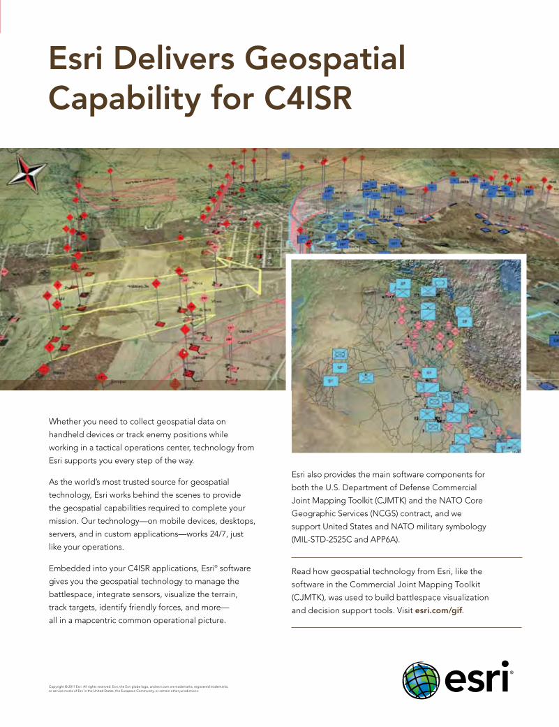
Esri Delivers Geospatial Capability for C4ISR
Copyright © 2011 Esri. All rights reserved. Esri, the Esri globe logo, and esri.com are trademarks, registered trademarks, or service marks of Esri in the United States, the European Community, or certain other jurisdictions.
Whether you need to collect geospatial data on
handheld devices or track enemy positions while
working in a tactical operations center, technology from
Esri supports you every step of the way.
As the world’s most trusted source for geospatial
technology, Esri works behind the scenes to provide
the geospatial capabilities required to complete your
mission. Our technology—on mobile devices, desktops,
servers, and in custom applications—works 24/7, just
like your operations.
Embedded into your C4ISR applications, Esri® software
gives you the geospatial technology to manage the
battlespace, integrate sensors, visualize the terrain,
track targets, identify friendly forces, and more—
all in a mapcentric common operational picture.
Esri also provides the main software components for
both the U.S. Department of Defense Commercial
Joint Mapping Toolkit (CJMTK) and the NATO Core
Geographic Services (NCGS) contract, and we
support United States and NATO military symbology
(MIL-STD-2525C and APP6A).
Read how geospatial technology from Esri, like the
software in the Commercial Joint Mapping Toolkit
(CJMTK), was used to build battlespace visualization
and decision support tools. Visit esri.com/gif.
G47800_GeospatIntelForum_May11.indd 1 4/21/11 12:43 PM